Saharan Rock Art: Local Dynamics and Wider Perspectives

Dipartimento di Scienze dell'Antichità, Sapienza Università di Roma, Via dei Volsci 122, 00185 Rome, Italy
Arts 2013, 2(4), 350-382; https://doi.org/10.3390/arts2040350
Submission received: 31 October 2013
/
Revised: 12 November 2013
/
Accepted: 14 November 2013
/
Published: 10 December 2013
(This article belongs to the Collection World Rock Art)
Abstract
:Rock art is the best known evidence of the Saharan fragile heritage. Thousands of engraved and painted artworks dot boulders and cliffs in open-air sites, as well as the rock walls of rockshelters and caves located in the main massifs. Since its pioneering discovery in the late 19th century, rock art captured the imagination of travellers and scholars, representing for a long time the main aim of research in the area. Chronology, meaning and connections between the different recognized artistic provinces are still to be fully understood. The central massifs, and in particular the "cultural province" encompassing Tadrart Acacus and Tassili n’Ajer, played and still play a key role in this scenario. Recent analytical and contextual analyses of rock art contexts seem to open new perspectives. Tadrart Acacus, for the richness and variability of artworks, for the huge archaeological data known, and for its proximity to other important areas with rock art (Tassili n’Ajjer, Algerian Tadrart and Messak massifs) is an ideal context to analyze the artworks in their environmental and social-cultural context, and to define connections between cultural local dynamics and wider regional perspectives.
1. Introduction
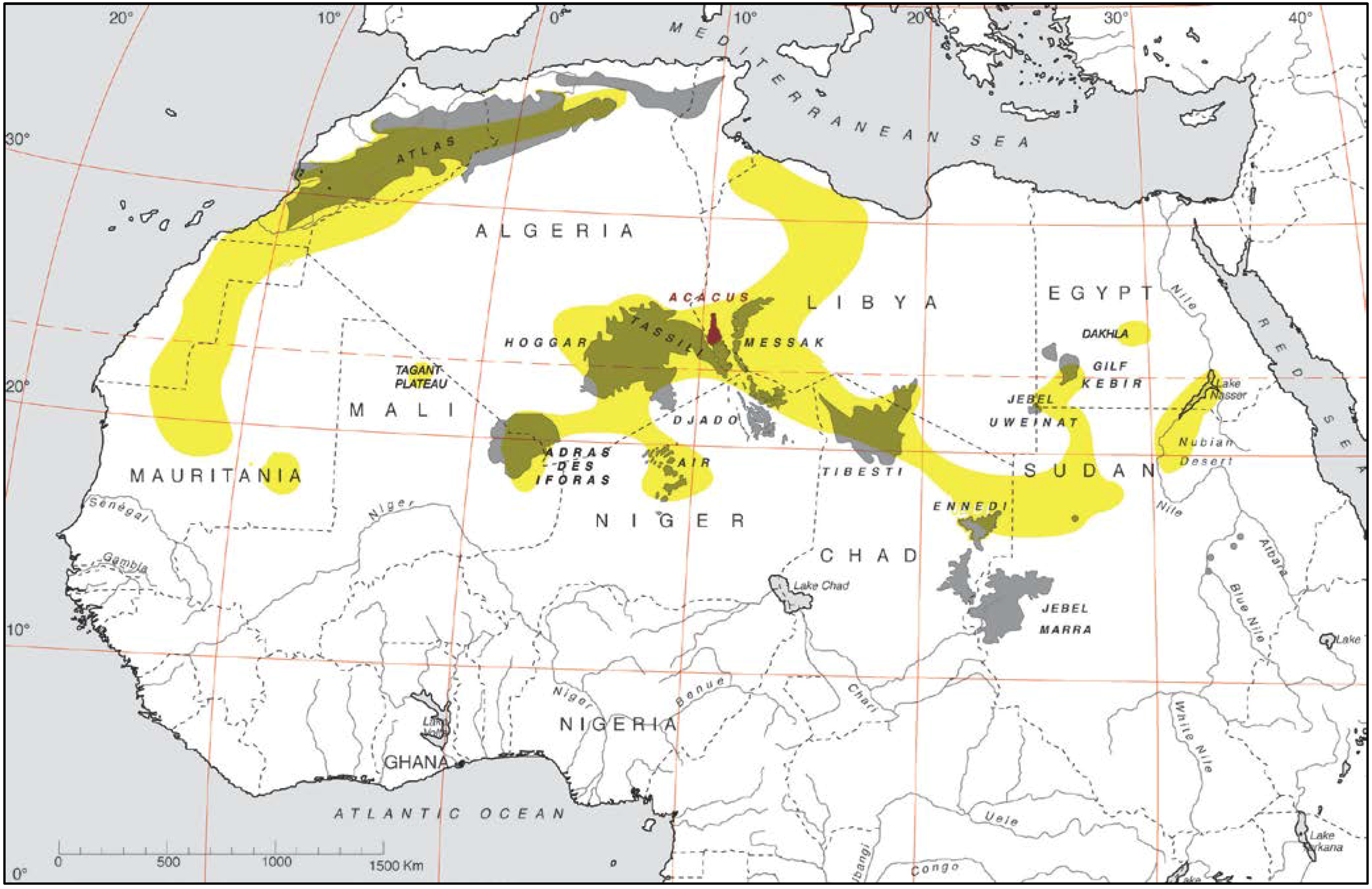
Saharan massifs are dotted by thousands of paintings and engravings; vanishing traces of humans that inhabited the region at least since the beginnings of the Holocene (Figure 1). The region is one of the warmest arid lands in the world, hard to cross and to live in, today almost completely uninhabited, but for a few resilient nomadic groups. For these reasons, the artworks remained unknown until the late 19th century, when the first exploration of the Great desert by western travellers started and rock art began to capture the imagination of the ‘Saharans’ and scholars, representing for a long time the main aim of research in the area. However, after more than two centuries, rock art is still scarcely known and understood. The rock art studies in the Saharan regions have been left behind in respect of the development of archaeological and multidisciplinary research carried out in the last decades (e.g., [1,2,3,4,5]). After important early studies, corresponding to the first scientific investigations (e.g., [6,7]), the research focused on chronological and stylistic issues, often carried out without a robust archaeological and anthropological perspective. Recent developments in the Saharan rock art study, based on new developments of indirect dating methods [8,9] and wide integrated contextual approaches [10,11] seems to establish the basis for a renewed season and future positive perspective.
Figure 1.
Map of the Sahara showing the main mountain systems and the major rock art concentrations (yellow).
Figure 1.
Map of the Sahara showing the main mountain systems and the major rock art concentrations (yellow).

This paper intends to summarize methods and aims of rock art research in the core of the central Saharan massifs, and to propose some suggestions stemming from a renewed territorial approach to the rock art sites of the Tadrart Acacus massif. This represents an essential framework for the further step of an integrated study of rock art (including a systematic classificatory, quantitative and semiotic reading), aiming at defining local dynamics to be compared in a wider regional perspective.
2. Background
Tadrart Acacus and Tassili n’Ajjer represent the emblematic contexts for the study of the Saharan rock art, for many reasons. Discovered later relative to other important rock art galleries, like Wadi Tilizzaghen in Libya [12], or the South Oran in Algeria [13], they rapidly became the key area of the Saharan rock art. The massifs in fact host an impressive amount of real masterpieces of prehistoric rock art and, since their first discoveries, have been object of research that changed aims and methods, reacting to the wider scientific framework. The researchers, mainly in the first pioneering period, aimed also to reveal this rock art to the Western world, leading to its acknowledgment by the international community as sites of outstanding universal value. Inserted respectively in 1982 and in 1985, the Tassili n’Ajjer and Tadrart Acacus still remain the only Saharan rock art contexts in the UNESCO World Heritage List.
The massifs are located at the core of the central Saharan massifs, encompassing the present south-eastern Algeria and south-western Libya, an ‘unnatural’ and shifting national border (as frequent in Africa) politically unstable, currently a real crossroad in the trans-Saharan and trans-African (often illegal) trades. The border cuts a wide cultural region—today still the domain of Tuareg groups—that, as the archaeological remains seem to suggest, has possibly its roots in the Pastoral Holocene cultures. The region in fact hosts a diffuse presence of archaeological remains, spanning from at least the Middle Pleistocene to the most recent Tuareg occupation, even if some interruptions, bound to critical climatic stages, can be envisaged. Rock art can reveal important elements for the reconstruction of the environmental, sociocultural, and ideological dynamics of past cultures, at least since the onset of the Holocene [2,6,14,15,16,17].
2.1 Aims and methods of the rock art study
The 1950s and 1960s have been repeatedly defined as the time of ‘pioneering’ research, when the massifs were almost simultaneously explored, and rock art discovered and reproduced by Tschudi [18] and Lhote and his team in the Tassili [7,19], and by Mori and his team in the Tadrart Acacus [6,20,21]. These years were completely devoted to the first survey of the rock art contexts and to their reproduction by master painters [22]. Even if this research is today highly disputed for the damaging impact that the recording procedures had on the paintings (e.g., [23,24,25,26]) and for its theoretical and methodological implications [22,27], it marked the beginning of rock art study in the area and produced the official documentation of the rock art until recent times. The rock art reproductions were in fact displayed at various exhibitions all around Europe [19,21,28,29] and for a long time were the iconographic support of any publication (e.g., [6,7,19,21,30]).
The 1960s were also characterized by an early ‘scientific’ archaeological approach that clearly had a strong effect on rock art studies, and laid the foundations for the main questions about chronology, techniques, meaning and conservation, which still constitute part of contemporary debate. In particular, Mori was the first to adopt in Tadrart Acacus a multidisciplinary approach to the rock art study with the following results: i. the research was expanded to the archaeological deposits hosted in rockshelters and caves with rock art; ii. the use of radiocarbon datings, just developed, allowed the fixing for the first time of a chronological frame reference for the rock art [6]; iii. the paintings were analyzed with a chemical perspective aiming at identifying the organic or inorganic origin of pigments [6]; iv. the main causes of weathering and damage were also investigated, and possible strategies of restoration were tested [31]. In Tassili, archaeological excavations started in the same 1960s, directed by Lhote, but data were only partially published and the chronological information, as recently discussed [32], are not clearly referable to the original contexts.
The 1970s and 1980s were devoted to investigating the correlation between climatic and environmental changes, human adaptations and the emergence of cattle domestication, with a site-oriented perspective, useful to fix the rock art evidence in its proper background [14,30,33]. Major new investigations were also carried out in Tassili, by Ginette Aumassip, even if they were limited to few main contexts [34,35,36]. It is noteworthy that, in 1972, the whole Tassili region became a National Park and consequently conservation studies and chemical analyses were carried out in the area [37,38,39,40].
During the 1990s, fieldwork activities in Tassili were hampered by the instability of the political framework. In the Libyan country, the fieldwork activities were characterized by extensive survey campaigns, and even if new rock art sites were discovered, the efforts were mainly focused on a territorial approach that led to a better definition of the environmental and cultural changes that occurred in the wider area including the Tadrart Acacus, the Messak massifs and the lowlands between and surrounding them (the Erg Titersin, to the west, the Erg Uan Kasa, between Acacus and Messak, and the Edeyen of Murzuq, south-east of Messak, e.g., [2,30]. It is furthermore important to quote the extensive surveys carried out by Axel and Anne Michelle Van Albada in the Messak the 1980s and 1990s, which gave a wider knowledge of the richness of the rock art in that region [41].
The debate on rock art followed two main paths: a heated discussion on the definition of styles and chronology, and a development of interpretative readings of images and hole rock art panels ultimately deriving from a structuralist perspective. The chronological debate developed around two main proposals both based on stylistic assumptions, superimpositions, studies of varnish, environmental conditions and represented subjects. A ‘long’ chronology (e.g., [6,30,36,42,43] identified the earliest rock art as a Late Pleistocene/Early Holocene production, due to hunter-gatherers, whereas a ‘short’ proposal [15,16,44] referred all the rock art evidence to the Holocene, starting with the Pastoral Neolithic. If a consensus is still to be gained, archaeological data [30,45,46] and indirect datings from OSL [9] seems to support the emergence of rock art at least since the early Holocene.
The theoretical and methodological interpretive issues have been developed with different approaches: i. attempts of a religious-symbolic reading of the rock art scenes proposed for the Round Heads [47] and Pastoral styles [16,48]; ii. systematic typological recording to be semiotically analyzed [49]; an ethnographical, historical and anthropological reading [50]; a semiological-contextual reading referring to specific artistic panels [51,52].
In the 2000s, it is possible to identify three main lines of research: i) in the Acacus area, we assist to a methodological change addressed towards a landscape approach and the contextualization and systematic recording of the rock art, in order to isolate and define the relationships between physical environment, archaeological contexts and rock art features [10,22,53,54]. In the same context ii) huge efforts were devoted to preservation and management issues, to tackle the changes taking place in Libya (e.g., [55]). In both areas, iii. one can record a renewed attention to the chronological issues, even if with different perspectives. The confidence in the methodological progress of radiocarbon dating led to a new season of field research in Tassili, where a French-Algerian project started in 2004 with the main aim of obtaining precise radiocarbon datings for the rock art of Ahaggar, Tassili n’Ajjer and Saharan Atlas [32,56]. Unfortunately, the project was interrupted after two field campaigns, limited to few renowned sites of Tassili, and the direct dating of paintings failed, as it did in Tadrart Acacus contexts (see discussion in [10,57]). However, it fostered a change of perspective. Radiocarbon datings were abandoned in favor of indirect methods of datings (excavation and OSL dating of sand deposits: [9,32] and towards a contextual study of rock art). The perspective is not straightforward anyway, as the harsh debate also inside the project team shows [9,32,56]. In the area of Acacus, during extensive surveys, several painting samples were collected and recently published [57]; as already quoted, all the radiocarbon datings (including those proposed by Mori and associates in 1996 and 2006 [58,59]) were considered unreliable, due to the poor state of conservation, and to a generalized problem of contamination [10]. The positive results of the contextual analysis of rock art evidence in the close-by Messak and in Acacus [3,4,10,60] set the base for the future perspectives of rock art studies in the region.
3. Context
3.1 Regional setting and palaeo-environment
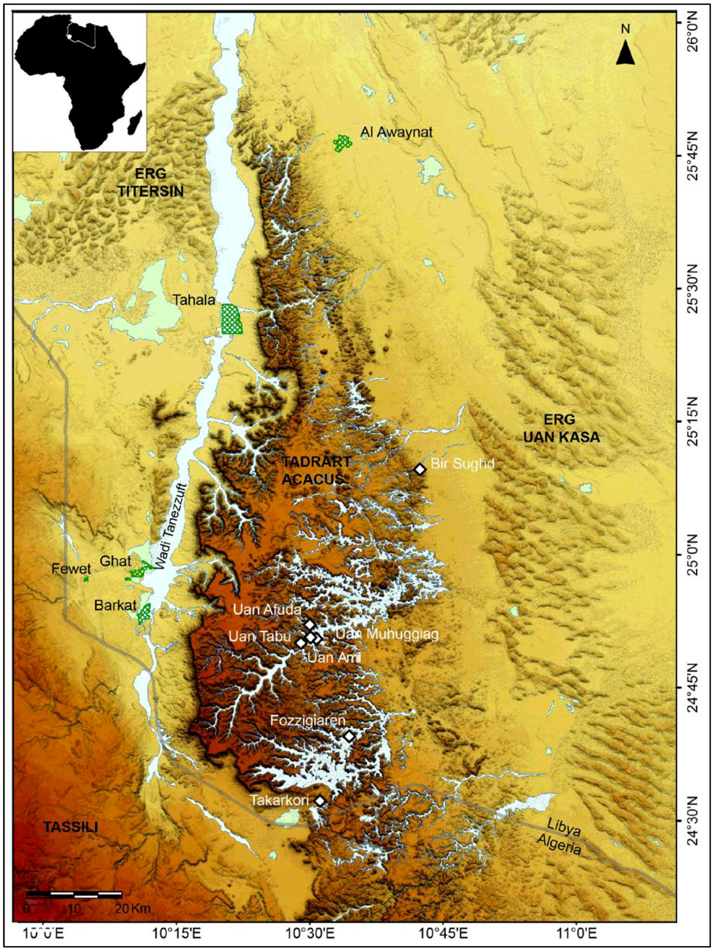
Tadrart Acacus is located in south-western Libya (Figure 2); it is a sandstone massif of cuesta type, with an elongated shape extending ca. between 26° and 24°30’ latitude N, and 10°10’ and 10°45’ longitude E and covering an area of more than 5,000 km2. The altitude varies between 600 m asl on the eastern and 1420 m asl on the western side, where an abrupt scarp defines the border with the underlying Wadi Tanezzuft. The massif is dissected by a fossil drainage network resulting in wide valleys and deep canyons—relicts of a landscape shaped by the tertiary equatorial climate—where prolonged processes of fluvial and pseudo-karst actions caused the formation of rockshelters and caves, located on terraces at different altitude along the steep slopes flanking the wadis and canyons [61,62].
The landscape is today harsh and dry for the hyper-arid climate, with a mean annual temperature of 30 °C and almost no precipitation, the mean annual rainfall ranging between 0 and 20 mm and taking place in spring and summer, but for occasional winter rainstorms [63,64].
Today, the massif is inhabited by few resilient Tuareg families, but in the past the area—like other parts of the Saharan region—was more suitable for life of humans and animals and for vegetation cover, as an effect of recurrent favorable climatic and environmental periods. In particular, the onset of the Holocene was characterized by a period of high rainfall, due to the northward migration of the Intertropical Convergence Zone, resulting in the expansion of the summer monsoon [1,65,66,67,68,69,70], possibly coincident with a southern movement of the Mediterranean winter rainy system [71], causing the recharge of the aquifers and the reactivation of springs, rivers and lakes. During this period, known as the African Humid Period, the establishment of a more humid environment and the presence of savannah vegetation cover [72] allowed the human reoccupation of the massifs, first by Epipalaeolithic and Mesolithic hunters and gatherers (locally known as Early Acacus and Late Acacus cultures), and later by Pastoral communities [2,62,73]. This period was far from being stable, as it was interrupted by several arid spells and ended around 5000 BP with a reduction of humidity that led to the present aridity state, even if with different timing and evolution, depending on the different physiographic units [62].
Figure 2.
Map of Tadrart Acacus with the location of sites and localities cited in the text.

3.2. Cultural and chronological frame
Multidisciplinary research carried out in the region since the 1960s enabled the reconstruction of a defined framework of the settlement, subsistence strategies and socio-cultural dynamics of humans inhabiting Acacus along the Holocene, from the early hunting-gathering communities, to the emergence of the first Pastoral society, to the development of the Garamantian state [2,6,14,15,16,17,74], until the Tuareg occupation [75]. Recent developments of research have enabled this general overview to be set out in more detail (e.g., [3,4,60,76,77,78]. This can be further integrated and improved by a deepened study of rock art evidence.
As briefly quoted, the onset of the Holocene was characterized by human re-occupation of the massifs, led by groups (called in the area Early Acacus culture) that colonized the massifs between 9800 and 8900 BP, with a subsistence based on the specialized hunting of Barbary sheep, and the gathering of wild plants [2,14,72,74,79,80]. As recently remarked [78], these groups probably occupied the massifs and the surrounding areas on a seasonal basis, with a ‘task-specific’ occupation strategy. The archaeological data are scarce and mainly from surface sites, but for four contexts from the north and central areas; however, the environmental proxies and the analysis of site distribution and of lithic assemblages led the authors to suggest a north-western origin of the culture.
The following occupation phase is marked by sharp cultural changes. Between 8900 and 7400 BP, the massifs were occupied by groups of hunter-gatherer-fishers with a ‘delayed-return’ strategy, mainly based on the management of Barbary sheep and the exploitation of plant wild resources, and a different use of the landscape, with a more intensive occupation of the mountain sites [81]. The diffuse presence of grinding equipment and the introduction of pottery witness a major shift also in material culture [46,82,83]. Those changes could be referred to external contacts, possibly with the eastern or southern areas [78].
From the second half of the VIII millennium BP until at least the beginning of III millennium BP, the Acacus was inhabited by Pastoral groups. At least four different phases of occupations have been recognized. The Early Pastoral phase (ca. 7400-6400 BP) follows a short arid spell, and is marked by the occupation, for long periods, of caves and rockshelters of the massif. It is characterized by the first presence and exploitation of domestic animals, both bovids and ovicaprids, in a wide-spectrum economy, as indicated since the first excavation of the Uan Muhuggiag rockshelter [6,84] and later confirmed by excavations at other sites [2,14,77].
A fully pastoral culture has been recognized in the Middle Pastoral phase, flourishing during the sixth millennium BP. This culture, widespread and recorded in most of the excavated sites, is probably the best known for the area. Groups of pastoralists performed a systematic strategy of transhumance between mountains and lowlands [73], exploited the secondary products of cattle [4], made a massive use of wild plant resources and were characterized by complex rituals (as highlighted in the nearby Messak, [3]). The climatic and palaoenvironmental drying from 5000 BP corresponds to Late Pastoral development (ca. 5000-3300 BP); subsistence strategies were redirected towards a high level of mobility, focusing on ovicaprid exploitation and a reduced use of plant resources. Since this period onwards, new cultural behavior emerges, involving the funerary sphere: megalithic burial mounds spread across the Sahara. The dynamics of their complex distribution are still to be understood. Final Pastoral groups (3300-2700 BP) were mainly located in the Wadi Tanezzuft area—the only physiographic unit still environmentally favorable in the area—that became the main settlement area in the final phase of the pastoral culture and in the following Garamantian period. Whether or not the settlement system involved the Tadrart Acacus is still unknown. The study of funerary practices in the Wadi Tanezzuft records in this period the first forms of social stratification that probably laid the foundations for the development of the Garamantian kingdom [85,86].
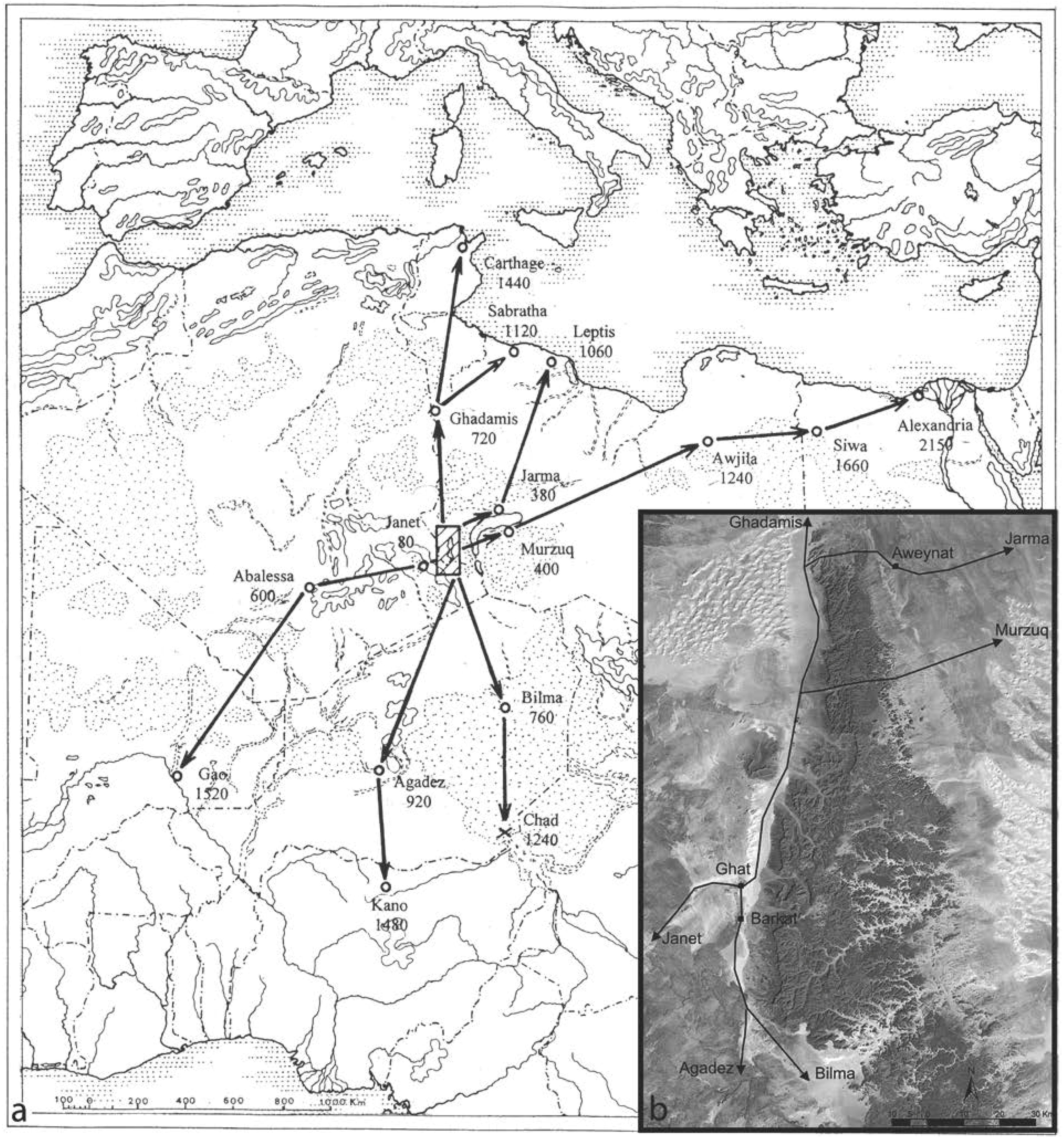
Between the I millennium BC and VI century AD, the region was the southern frontier of the Garamantian kingdom, the first known Saharan state, with its center in Garama in the Wadi el Ajal, the northern border of the Messak massif (e.g., [17,86,87]). The kingdom was based on a pastoral and agricultural economy, with the intensive horticulture in the oases, and a diffuse trans-saharan trade network. Around the Tadrart Acacus, the archaeological data for this phase come from the fortified citadel of Aghram Nadharif, on the eastern fringes of the Barkat Oasis, in the southern Wadi Tanezzuft ([17] herein), from the small oasis village of Fewet and its cemetery, located to the west of Ghat [88,89], and from some isolated castles recorded and investigated on the eastern side of the Awiss area [90] (Figure 3). The occupation of the massif in this period is presently scarcely attested, but for few data from dung deposits of Uan Muhuggiag rockshelter [91] and Uan Amil cave [92] —both located in Wadi Teshuinat—and from the recent investigation of the etaghas (areas with geomorphological and soil characters suitable for flood-recession cultivation [60]) and guelta contexts (natural rocky water reservoirs [60]).
The post-Garamantian occupation of Tadrart Acacus is still almost unknown, but for recently investigated evidence [60,75,76], referring to historic caravan trade and pastoral presence in the area. Recent ethnoarchaeological research recorded and deepened our knowledge of the present occupation of the resilient Tuareg families still inhabiting the region, both in the village of Tabarakkat, close to the oasis of Al Awaynat and in campsites located along the course of the dried river valleys, with a major persistence in the central Wadi Teshuinat [60,75].
3.3. Rock art styles and chronology
The definition of styles and chronology, as formerly quoted, was the core point of much of the rock art research in the area. The styles described here still refer to the terminologies used by Lhote [19] and Mori [6] and their dating has been proposed by taking into account: i. as for the engravings, indirect dating thanks to the superimposition of furrows and rock varnish development [57,93,94]; ii. indirect datings of materials (e.g., pigments or decorated panel fragments) included in archaeological deposits, dated with radiocarbon, like the buried stone with painted cattle at Uan Muhuggiag, in the Wadi Teshuinat [6] and iii. the contextualization of rock art sites, both as single entities and by correlating rock art distribution with the main phases of human occupation archaeologically recognized, as synthesized in the previous paragraph (e.g., [10]). Nonetheless, the debate on these ‘traditional’ definitions is still lively.
The styles can be shortly presented as follows:
Wild Fauna (or Bubaline: [15,16]) style is the most debated phase. It has been traditionally defined and described as a style including only engravings representing wild animals, typical of humid, southern environments: big mammals like elephants, rhinos, giraffes, wild bovids, and rarely felines and reptiles, represented, either isolated or in groups and often represented almost natural size. On the basis of superimpositions, the nature and weathering of the rock varnish, the type of subjects, and specific stylistic aspects, these engravings have been thought to be the earliest form of Saharan rock art, and a possible cultural framework has been identified in the Early Acacus hunter-gatherers culture. However, stylistic, chronological and cultural attribution is still problematic. The unsolved problem of the dynamics and timing of repopulation of the central Sahara [78,95], and the presence of rock art at Qurta in the Upper Egyptian Nile Valley, indirectly dated as early as the end of the Pleistocene (probably around 19000-17000 calBP), through OSL analyses of the sediments partially covering the engravings [8], suggest that we should reconsider the available data, and develop the research with analytical and methodological improvements.
Figure 3.
(a) Tadrart Acacsu in the trans-Saharan trade network (after [17]: 451). (b) Detail of the caravan routes (after [17]: 453).

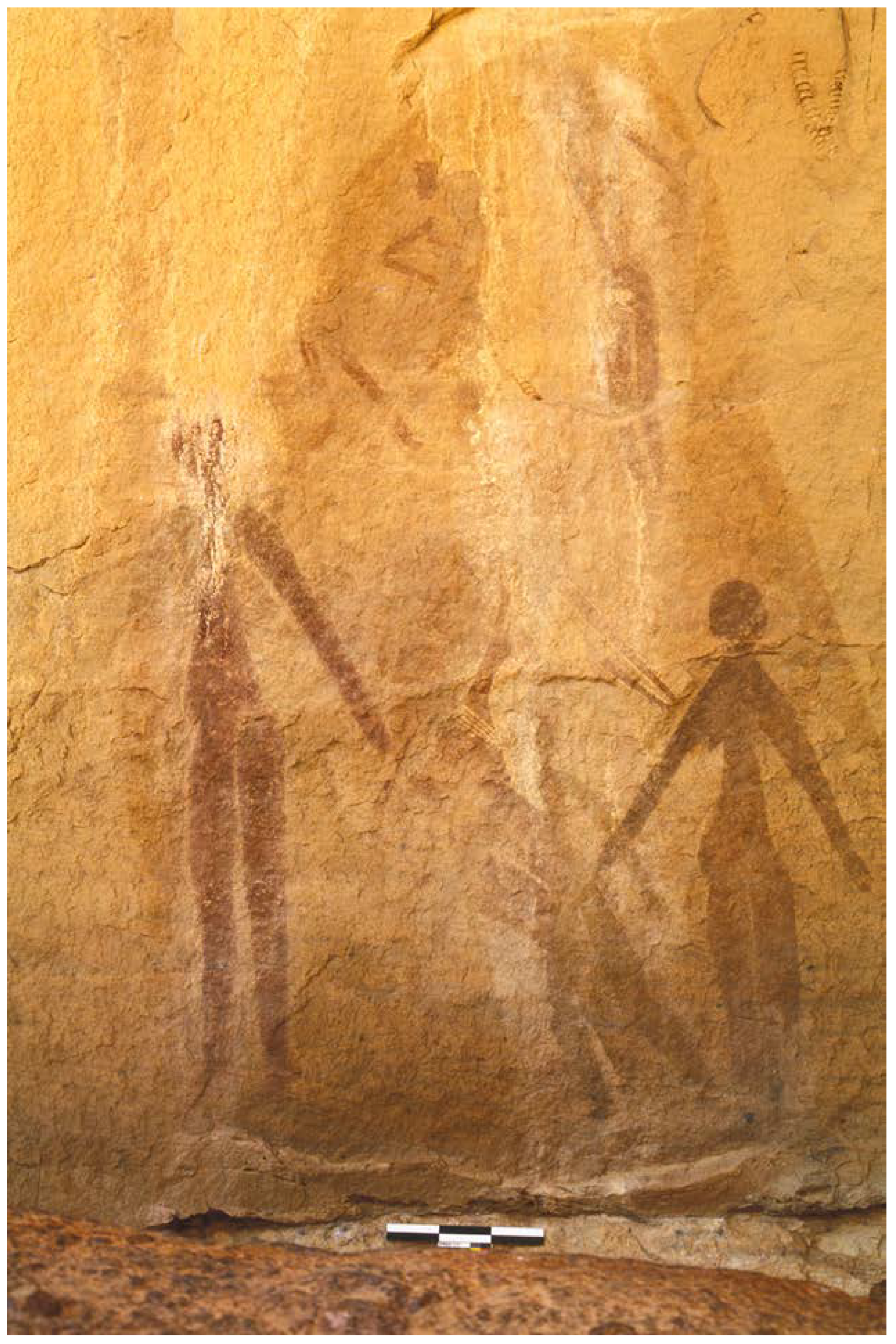
Round Heads style is represented both by paintings and rarely engravings decorating the walls of rockshelters and caves. The represented subjects are anthropomorphic figures with rounded heads, often associated with wild animals, especially Barbary sheep and antelopes. Hunting scenes, as well as complex scenes of dance or ritual activities traditionally referred to a sacred and symbolic sphere, are the main character of this style. The traits are steady; the painted figures are generally represented in profile and can be realized with different techniques: a simple contour, in flat color, or polychromy (Figure 4). The Late Acacus foragers represent the possible cultural and chronological frame for this style, possibly persisting also in the first Pastoral period [15,16,96]. The style has been ever interpreted as a local artistic expression, and has been object of detailed studies [47,96,97]. However, a regional investigation of this phenomenon could open new scenarios of research, integrating the other data of material culture and allowing us to propose contacts with the eastern or southern side of Sahara.
Figure 4.
Round Heads red paintings, from T-Anshal-t rockshelter.

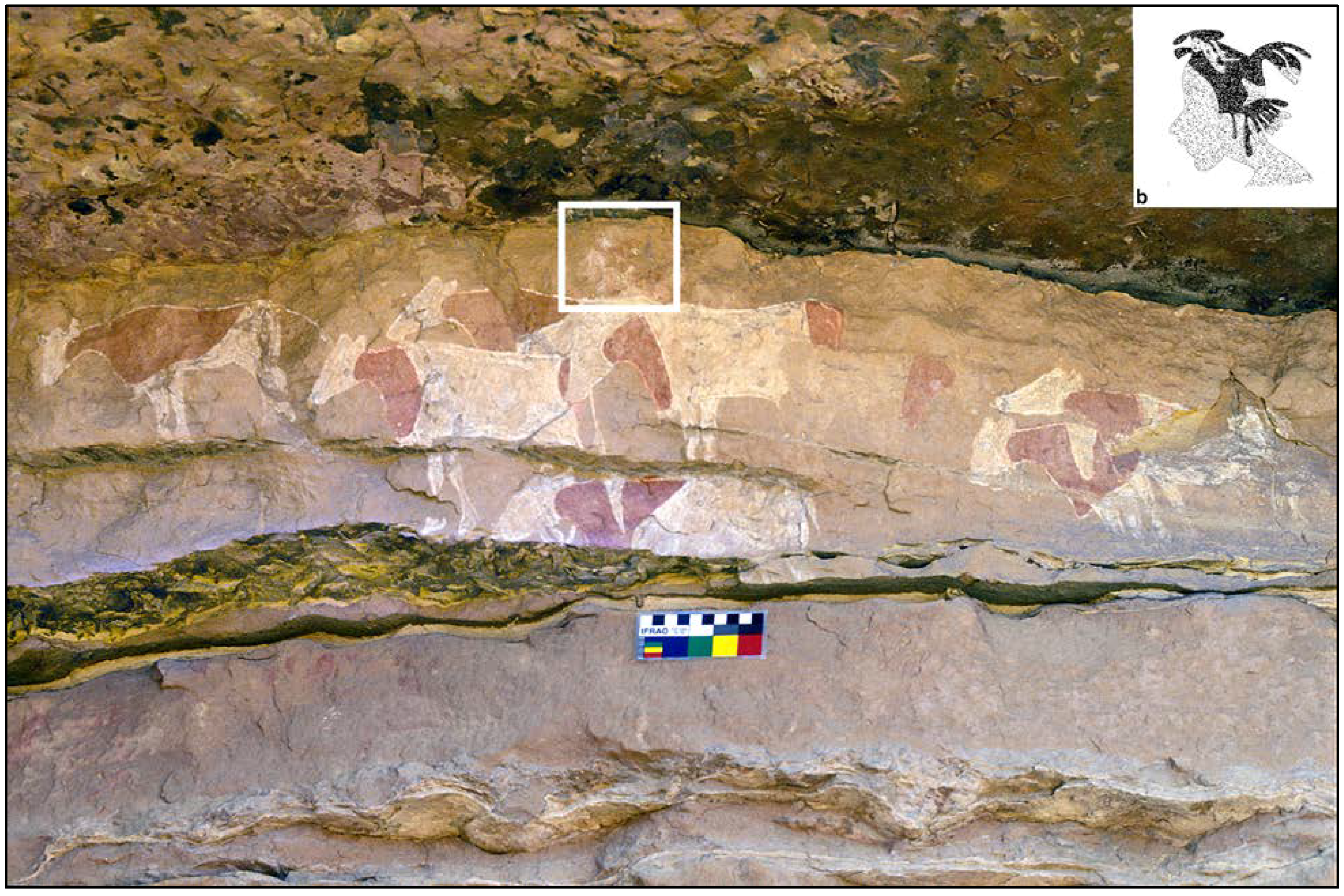
Pastoral or Bovidian style represents the most common type of rock art, with thousands of sites throughout the Sahara. The main subjects refer to domestic cattle and pastoral life. Scenes of daily activities, as well as milking and management of herds, alternating with hunting or ritual scenes, emphasize the complexity of these pastoral groups (Figure 5). The artworks are in a naturalistic style in flat color or polychromy; the subjects are reproduced in various attitudes and with many details, e.g., body paintings, clothing, and hairstyles. While the apex of the style is most likely referable to the Middle Pastoral culture [4,6,10,30], a huge effort is still needed to better define the different sub-styles (or "schools") that can be envisaged. On the basis of archaeological data, it is possible that this style lasted from around the mid-eight millennium BP to the onset of fourth millennium BP.
Figure 5.
(a) Pastoral style scene from Wadi Afozzigiar. (b). Sketch of the herdsman in the middle of the scene (white frame).
Figure 5.
(a) Pastoral style scene from Wadi Afozzigiar. (b). Sketch of the herdsman in the middle of the scene (white frame).
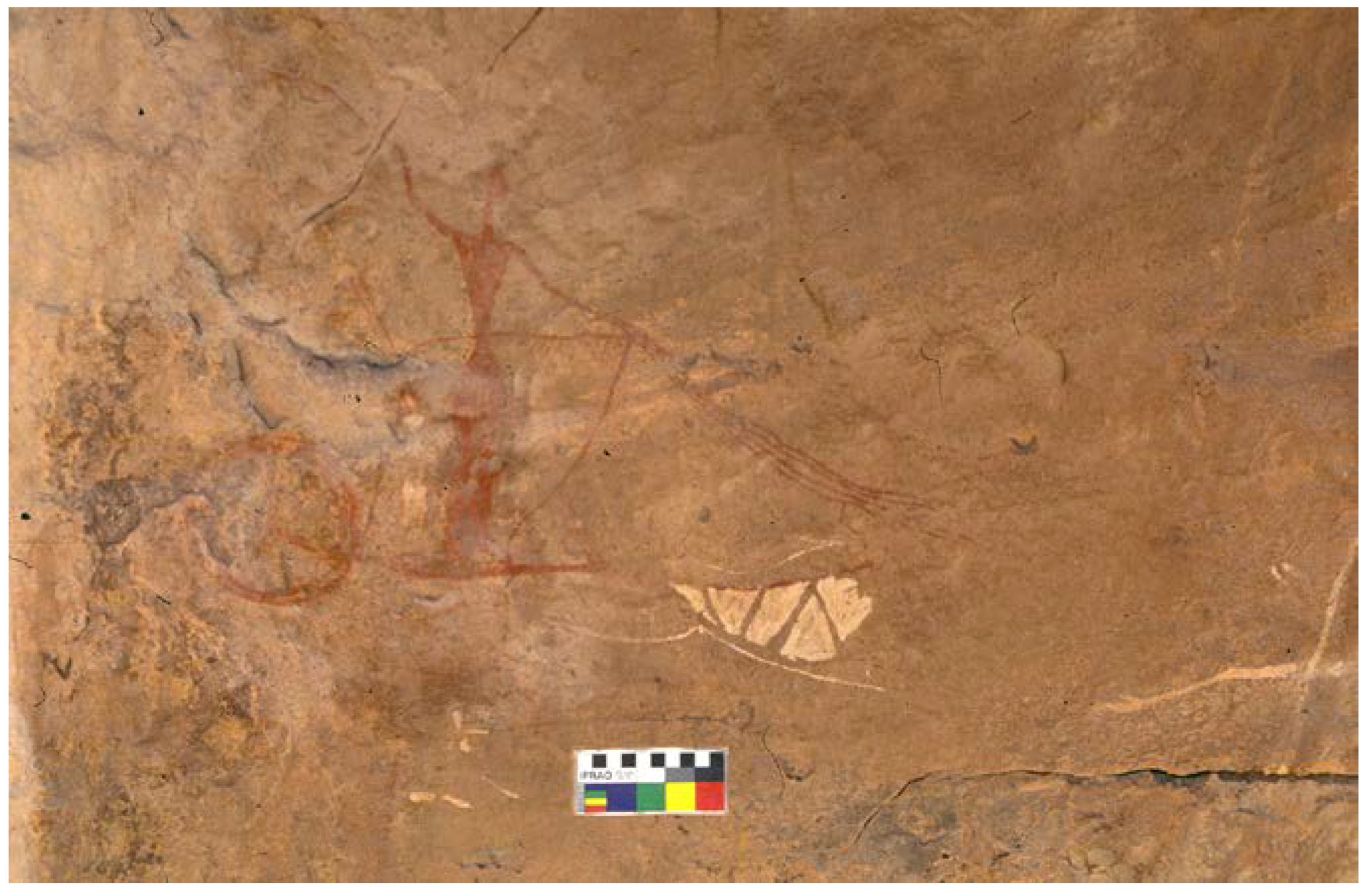
Horse/Bitriangular style includes mostly paintings, but also some engravings. The bitriangular geometric representation of human figures in flat color, and the appearance of domestic horses, are the main distinctive trait of the style, characterized by a wide variability of the represented scenes, which include both pastoral scenes, domestic activities, and conviviality, often in an oasis context, and hunting/war scenes with flying, galloping chariots, or fights where humans wield a spear or lance (Figure 6). The represented scenes reflect the final phases of the Pastoral period and the early Garamantian culture, approximately between the fourth millennium BP and mid-third millennium BP.
Figure 6.
Painted chariot in Bitriangular/Horse style, in T-Afozzigiar-t rockshelter.
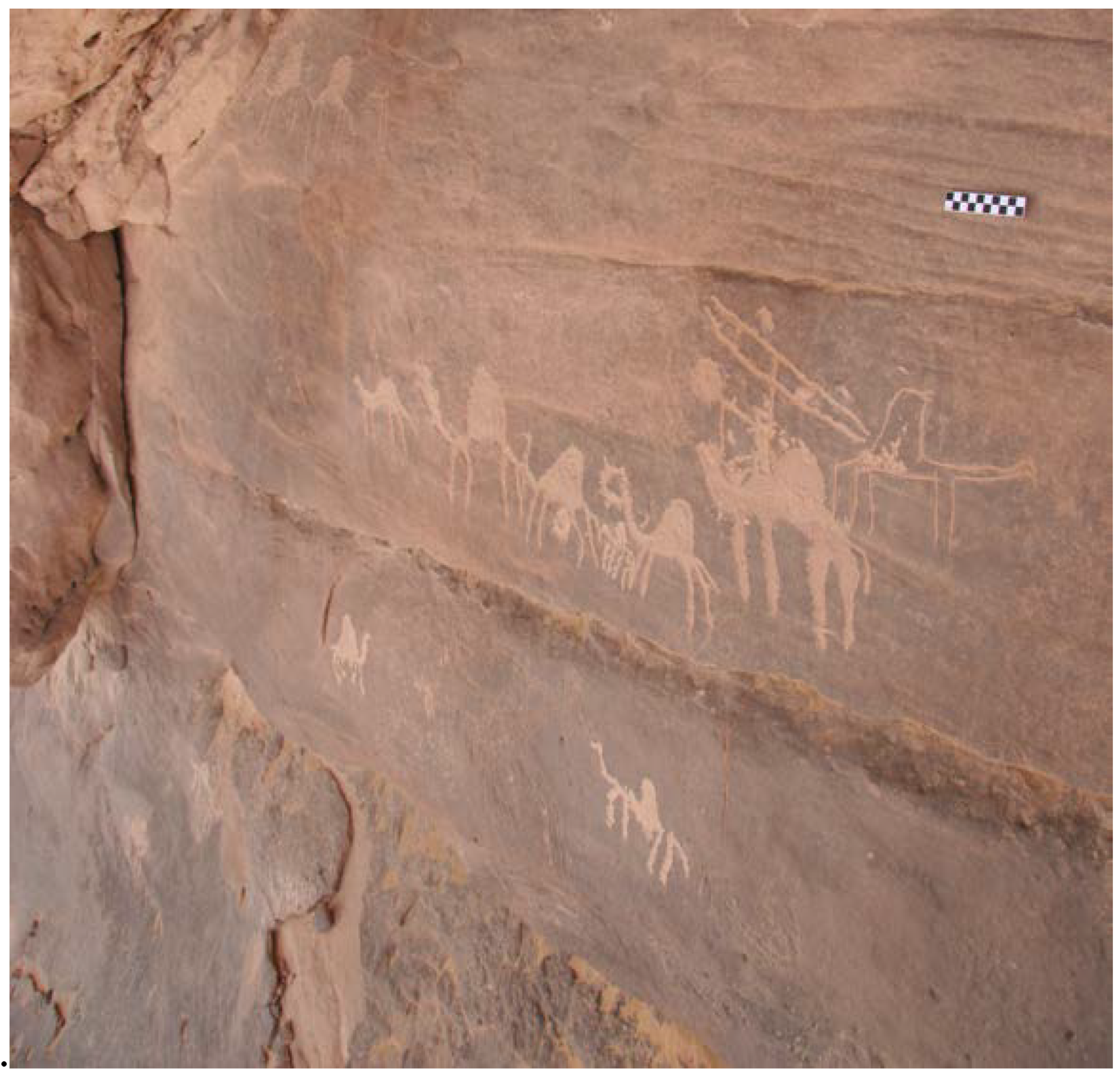
Camel style is also widespread; it typically features the representation of camels (Camelus dromedarius). Other subjects include highly stylized bitriangular human figures, flocks of goats, caravans, palm trees, and hunting or battle scene. The high schematism, the low accuracy of the representations and its late date determined a scarce interest by the scholars, more interested in artworks of higher aesthetical quality, for an implicit cultural prejudice. (Figure 7) The phase is traditionally associated with the classic and final phases of the Garamantian culture (third century BC to sixth century AD).
Figure 7.
Caravan in Camel style along the rock wall of Ti-n-Abrukin rockshelter.

The post-Garamantian phases are still poorly known and Camel style traditionally included any rock art evidence possibly referred to later phases; in this paper it is believed that there is a need to define a new style, here labeled as ‘Modern Camel’ that includes highly schematic drawings, both painted and incised, among which are subjects clearly referable to the modern age, like four-wheel drive cars (Figure 8). It has been recently remarked that this art must be considered for its heritage value and the potential in opening new scenarios about the most recent phases of the massif’s occupation [10].
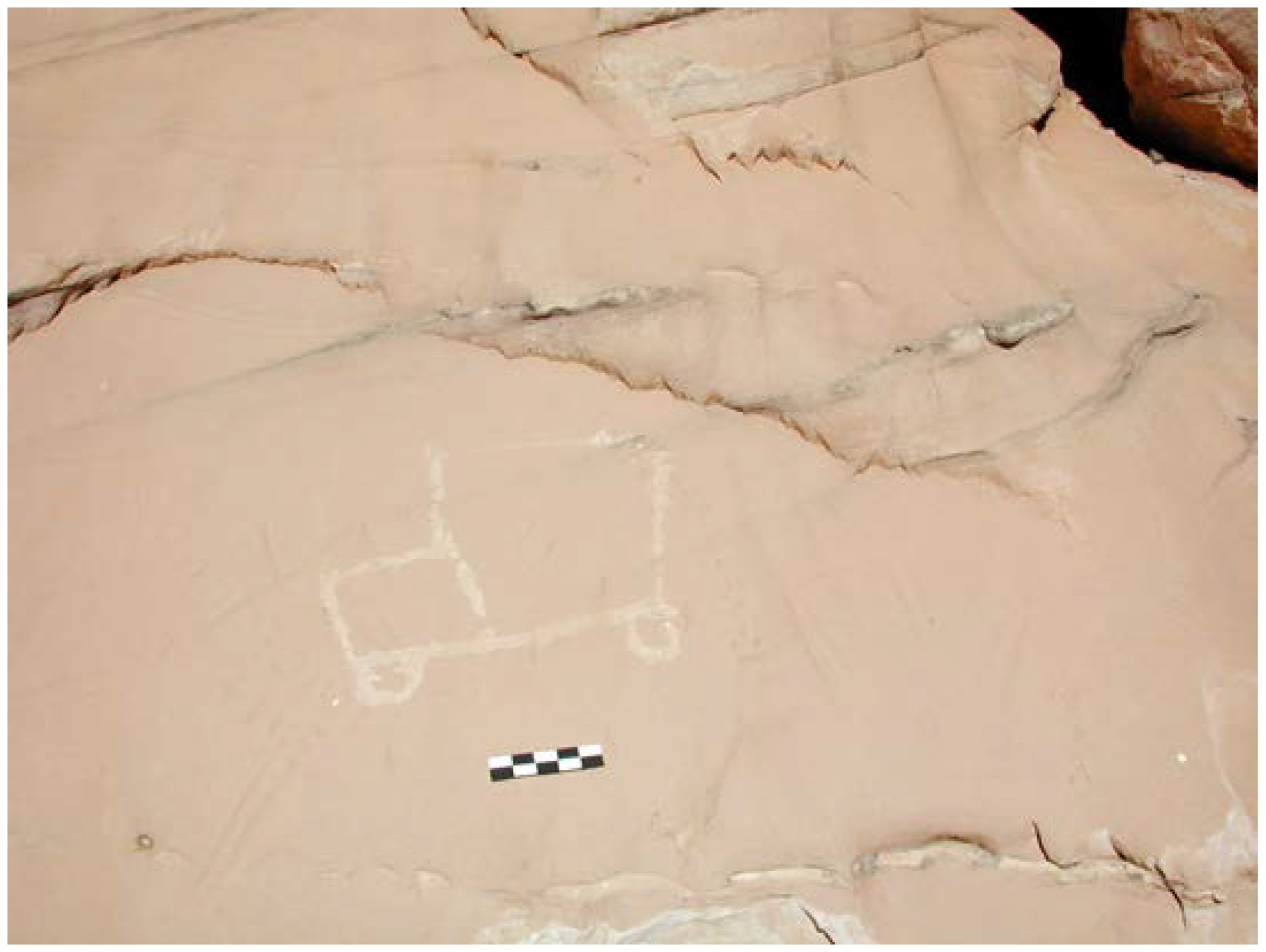
Figure 8.
Modern Camel Style: four-wheel drive car, engraved on a rockshelter in Wadi Rahrmellen.

In the massif, two different kinds of mainly rock-cut and seldom-painted writings are also recorded: Tifinagh (Figure 9) and Arabic.
Figure 9.
Panel with Tifinagh engravings, from Ti-n-Lalan site (Wadi Sennadar).
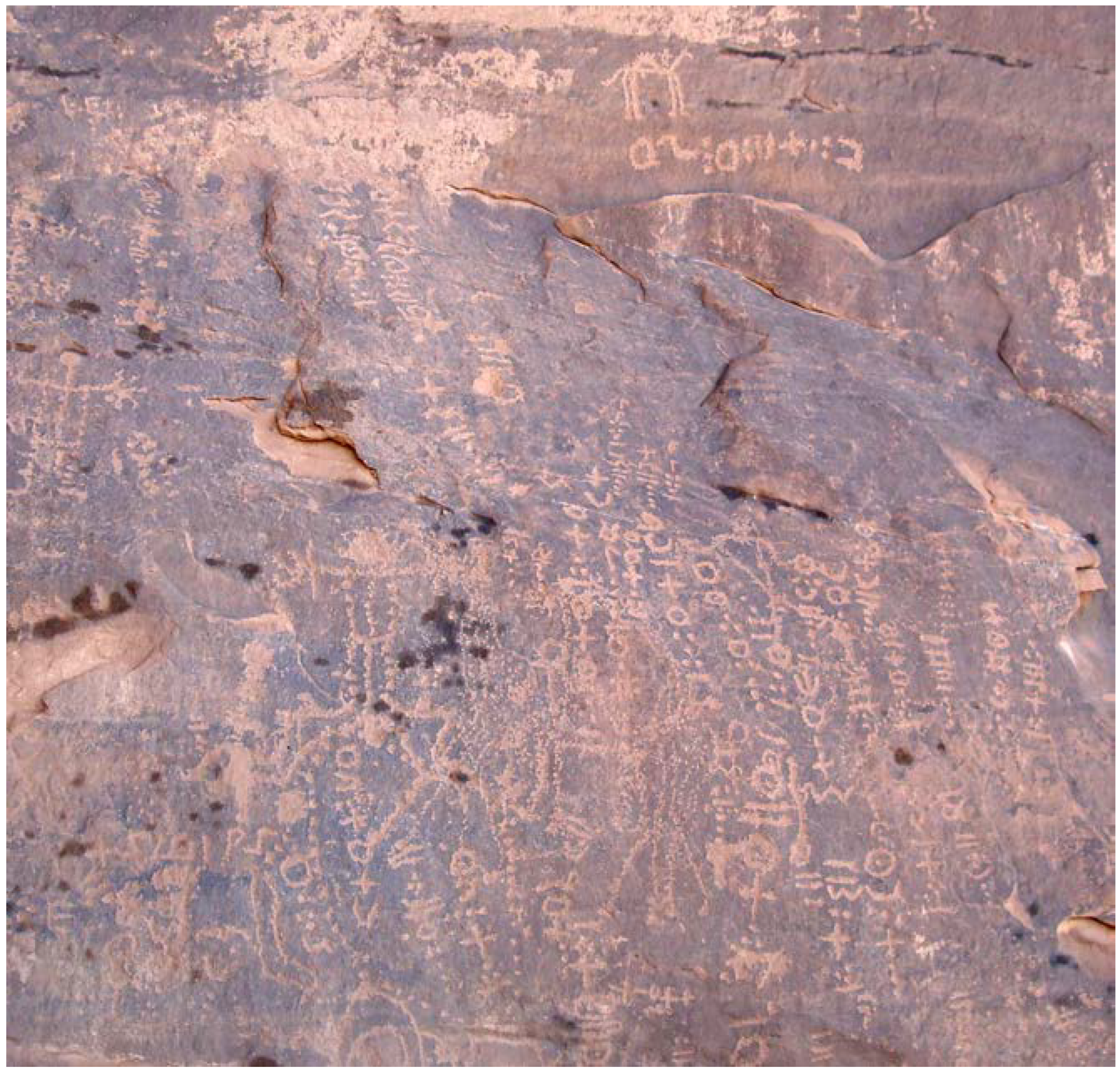
The earliest occurrence of Libyco-Berber (Tifinagh) inscriptions has been dated to the Garamantian phase, as a first testimony of writing (e.g., [17]). These texts, carved or painted on the stone walls of the Tadrart Acacus, are anyway hardly datable with precision: they cover a long chronological span, ranging from the Garamantian to present times and to present day, as the Tifinagh alphabet is still used by local Tuareg groups. A recent survey, recording and partially interpreting the texts, allowed to define the chronological trend of Tifinagh writings in the Acacus: even if the percentage of not determinable panels is very high (ca. 80%), at least two panels are clearly referable to a pre-Islamic period (prior to the seventh/eight century AD [76]).
As for Arabic writings, a systematic work is still lacking; however, it is evidence that is not to be overlooked, even if it could be a very recent one.
4. Analysis and discussion
4.1 Materials
The present analysis considers the main rock art sites known in the Tadrart Acacus massifs, up to 2010. After the Libyan revolution occurred in 2011, field research in the area has been interrupted. A total amount of more than 700 sites has been considered. They include: a) sites recorded and published by Mori [6,30]; b) sites located during the geoarchaeological surveys carried out in the 1990s by Cremaschi and di Lernia [2]; c) the results of systematic rock art surveys developed between 2001 and 2008 carried out by D. Zampetti and colleagues; d) the outcome of the Tifinagh rock inscriptions Project [76]; e) the published contexts recorded and published by Choppy et al [98]. Data reflect aims and methods of the fieldworks and information can vary from a simple positioning to a full detailed recording including 3D models. To overcome this heterogeneity, only the main aspects of the sites will be considered (location; main physiographic and geomorphological attributes; stylistic, quantitative and qualitative attributes of represented artworks), presenting a general overview of the rock art data set available for the Tadrart Acacus massif, that expand and modify previous analyses, addressed to conservation and management issues [55].
The boundary, extent and nature of a rock art site are of course the major problems in approaching its study at any level, as continuously stressed in papers and compendia (e.g., [99,100,101]). There is no general consensus to solve the topic and often the definitions are subjective, but by making the rationale for the definition of a site clear, it becomes possible to enlarge the perspective and to analyze datasets at different scales. In this, and in former studies, our research team conventionally defined a site any engraved/painted figure or cluster of figures (zoomorphic, anthropomorphic, phytomorphic or abstract sign) occurring within a ‘physically defined’ space [55].
The rock art of Tadrart Acacus occurs mainly in discrete geographic entities (caves or rockshelters), or in open-air contexts (isolated boulders, slabs, exposed outcrops or cliffs). Mainly in the latter cases, the site definition could be widely arbitrary and it has been set following the clustering and the apparent coherence of the evidences.
All available data have been entered in a relational database, including both site information and style attributes.
For each site, a few main attributes have been considered, referring to its geographical location (coordinates, toponyms), geomorphological setting (physiography, main geomorphological context, site type, support) and to the main artistic styles recorded.
‘Physiography’ refers to the landscape surrounding the site and includes: wadi bottom (flat alluvial valleys crossing the massif), 1st terrace (flat geological structure 30–100 m above the wadi bottom), 2nd terrace (remnants of the peneplain existing in the interfluvial areas), intemediate (position between the wadi bottom and the 1st terrace) and the escarpement that constitutes the western border of the massif.
‘Main geomorphological context’ specifies the geomorphological context of the site as well as the position in respect to the wadi or the close presence of aqba (passageways in Arabic, consisting of narrow mountain trails, featuring a steep slope that crosses the western escarpment of the massif [76]), gueltas (natural rocky water reservoirs [60]), or etaghas (areas with geomorphological and soil characters suitable for flood-recession cultivation [60]).
‘Site type’ refers to the site context (cave, rockshelter or open-air), where the ‘support’ for the art evidence (wall, cliff, boulder, slab or exposed outcrop) is set.
As is frequently the case in a rock art context, the same site can host images referable to one or more styles, and for each style represented from each site (quoted as "style testimony") the following attributes have been considered: ‘technique’, ‘quantity’, ‘state of preservation’, and ‘significance’. Obviously this kind of data treatment summarizes a huge amount of attributes referred to any single rock art feature present in each site, but it is useful in order to have a wide overview of the main distribution and characteristics of the known rock art heritage for the region (as suggested in [55]). ‘Technique’ includes only painting or engraving. ‘Quantity’ represents an estimate of the frequency of figures of the same style: scarce when simply one or two subjects are present; average when the number of subjects has a moderate value (values can range between three and ten depending on the style); abundant when the total amount of images is greater than the average medium value of the the sites; ND if data are not available (not collected, etc.). ‘State of preservation’ refers to the physical state of the rock art evidence, defined as bad if the painting/engraving is highly damaged or very faded; scarce if the outline of the figures is visible but details are not recognizable; good when also the details of figures are visible; ND if data are not available (not collected, etc.). ‘Significance’ was introduced in the database following the cultural resource management issue, with the aim to recall the UNESCO concepts of “outstanding universal value” and emphasize the “quality and exceptional nature” of the site ([55]: 165). It is a subjective evaluation of rock art evidence, synthetically referring to the perceived relevance of each style products represented in a single site, it allows the management of several factors that are difficult or impossible to encode (e.g., complexity, originality, rarity and cultural/archaeological value). This keyword has the following scale of values: low significance has been attributed when the artworks of the style do not include peculiar traits enhancing the knowledge of the style; medium significance when the artworks present the widely diffuse traits of the style; high when the artworks represent an exceptional expression of a style; ND when data are not available (not collected, etc.).
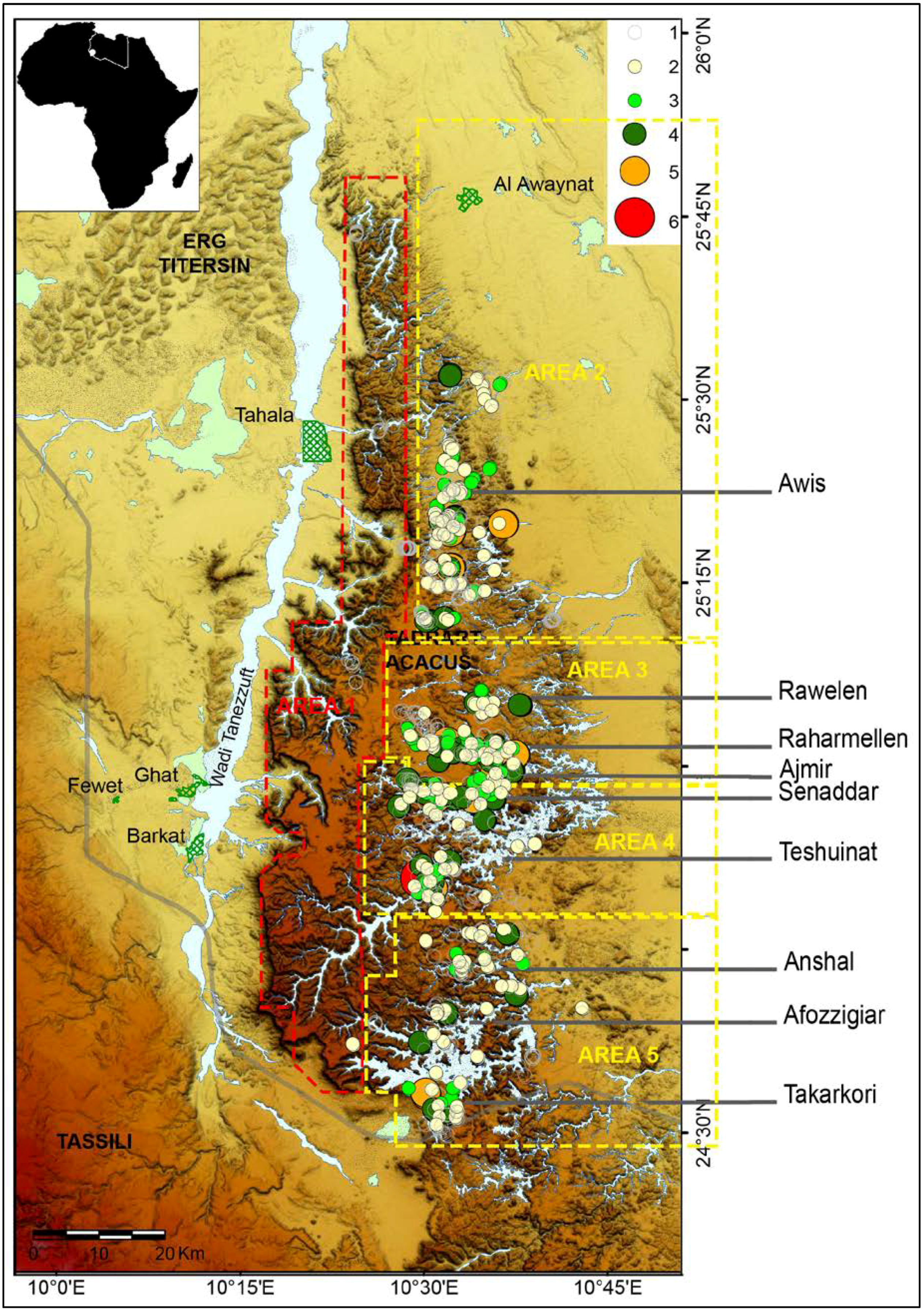
In order to better analyze the main distributions of rock art evidences, the Acacus massif has been sub-divided in five areas according to the different geographic and geomorphological characters (Figure 10).
Figure 10.
Map of Tadrart Acacus with the distribution of rock art sites, marked as dots scaled by the number of rock art styles present in the site; the five areas used in the analysis have been traced.
Figure 10.
Map of Tadrart Acacus with the distribution of rock art sites, marked as dots scaled by the number of rock art styles present in the site; the five areas used in the analysis have been traced.

Area 1 corresponds to the western side of the massif, characterized by a deep scarp, major altimetry values and by the presence of few narrow and deep wadis. Area 2 includes the northern side of the massif to the Wadi Sughd area, traditionally known as Awiss. It is geomorphologically rugged with a substantial hydrographic system and a progressively decreasing slope towards north. The morphology lacks the imposing rock structures with vast shelters or caves present in the rest of the massif [30]. Area 3 extends between Wadi Rawelen and Wadi Ajmir, and includes the main system of wadis known as Rahrmellen and its minor tributaries. The wadis are cut in deep canyons delimited by vertical walls affected by massive landslides and rich in rockshelters and caves ([53]: 194). Area 4 corresponds to wadi Teshuinat. The area presents the main hydrographic artery of the massif, with a complex network of long and dendritic tributaries and valleys. Numerous wide and deep rockshelters are located on the walls flanking the wadis and the steep slopes of the canyons. Area 5 is the southernmost part of the massif, characterised by the Wadi Takarkori and its complex network of tributaries. The northern Wadi Imha and Wadi Anshal are deeper and smaller; proceeding southwards wadis are wider and longer. Also, many rockshelters and caves are located in this area. Wadi Takarkori represents a major geographic divide, partitioning the Libyan Acacus from the Algerian Tadrart, its natural prosecution.
4.2. General distribution of sites
A total amount of 707 rock art sites have been recorded and analyzed; about 57% of them include just one single style, while the remaining ones can include images referable up to six styles (Figure 10). As a general overview, the sites are highly differentiated in the five main areas, as for type of site, physiography and distribution (Table 1).

| Area | N° | Physiography | Site type | |||||||
|---|---|---|---|---|---|---|---|---|---|---|
| Wadi bottom | Intermediate | 1st terrace | 2nd terrace | Escarpment | ND | Open Air | Rockshelter | Cave | ||
| 1 | 55 | 16 | 0 | 1 | 0 | 38 | 0 | 55 | 0 | 0 |
| 7.8% | 3.8% | 0% | 2.3% | 0% | 100.0% | 0% | 19.9% | 0% | 0% | |
| 2 | 223 | 106 | 24 | 5 | 0 | 0 | 88 | 114 | 108 | 1 |
| 31.5% | 24.9% | 22.2% | 11.4% | 0% | 0% | 100.0% | 41.2% | 26.3% | 5.0% | |
| 3 | 151 | 114 | 30 | 7 | 0 | 0 | 0 | 53 | 93 | 5 |
| 21.4% | 26.8% | 27.8% | 15.9% | 0% | 0% | 0% | 19.1% | 22.7% | 25.0% | |
| 4 | 148 | 113 | 21 | 14 | 0 | 0 | 0 | 28 | 111 | 9 |
| 20.9% | 26.5% | 19.4% | 31.8% | 0% | 0% | 0% | 10.1% | 27.1% | 45.0% | |
| 5 | 130 | 77 | 33 | 17 | 3 | 0 | 0 | 27 | 98 | 5 |
| 18.4% | 18.1% | 30.6% | 38.6% | 100.0% | 0% | 0% | 9.7% | 23.9% | 25.0% | |
| Total | 707 | 426 | 108 | 44 | 3 | 38 | 88 | 277 | 410 | 20 |
| 100.0% | 100.0% | 100.0% | 100.0% | 100.0% | 100.0% | 100.0% | 100.0% | 100.0% | 100.0% | |
Area 1 is exclusively characterized by the presence of sites with Tifinagh, a fact discussed by Biagetti and colleagues [76]. The sites (55), all of open-air type, host only engravings and are mainly located at high altitude, in correspondence of the aqbas, which allow a west-east transit of the Acacus.
The highest number of sites (31.54 % n 223) occurs in area 2, where engravings are highly recorded as well (with an incidence of almost 70% for the recorded style testimonies). Artworks are almost equally located in open-air (the highest incidence in the massif) and rockshelter sites, but for one single cave.
A total amount of 151 sites, with a high incidence of rockshelters and a high frequency of engravings have been recorded in area 3. All the sites are located along the wadi banks, with the Intermediate and first terraces being exploited as well, but they reveal specific distributions: Wadi Rawelen hosts the main amount of sites along the middle course; Wadi Rahrmellen shows a diffuse presence of sites along the middle and initial course, both of the main wadi and its tributaries; a high presence of rock art sites also characterizes the initial part of Wadi Ajmir.
Area 4 hosts 148 sites, with the highest number of rock art sites in caves (9), and a low amount of open-air sites (28). In this area, the highest frequency of paintings can be found (159). As we have remarked before, the area corresponds to a complex network of valleys and wadis constituting one of the main hydrographic arteries of the massifs, known as the Wadi Teshuinat basin. Also in this area, the distribution of sites changes for each wadi: along Wadi Senaddar the sites are located all over the wadi course; Wadi Teshuinat shows instead a high clustering of sites in the middle course. In both wadis all the physiographic units are exploited.
A high presence of paintings has been recorded also in area 5, where 130 rock art sites, mainly rockshelters, are located, even in the highest physiographic units. The distribution varies almost in each wadi: Wadi Imha is the only wadi with a diffuse presence of rock art sites all over its course; Wadi Anshal and Wadi Afozzigiar show a similar pattern, with a dense cluster of sites in the middle course; Wadi T-Anshal-t is the only one with rock art sites at the end of the wadi course; as for Wadi Takarkori, sites are clustered on its southern side.
To resume, from a first analysis of frequency and distribution of sites per area it is evident that even if the geographic and geomorphological characters of the main areas play a role in frequency of the site type (providing different kind of location and supports), density and distribution of sites seems not to be exclusively dependent on these parameters. Some wadis show similar patterns, both in the same and in different areas, such as wadis Wadi Anshal and Wadi Afozzigiar in area 5, and Wadi Rahrmellen and Wadi Senaddar, respectively in areas 3 and 4; in some other cases morphologically similar wadis do not share the same pattern, like Wadi Imha and Wadi Anshal, both in area 5. It is useful to approach this variability by style/phase.
4.3. Discussion of distribution by style/phase
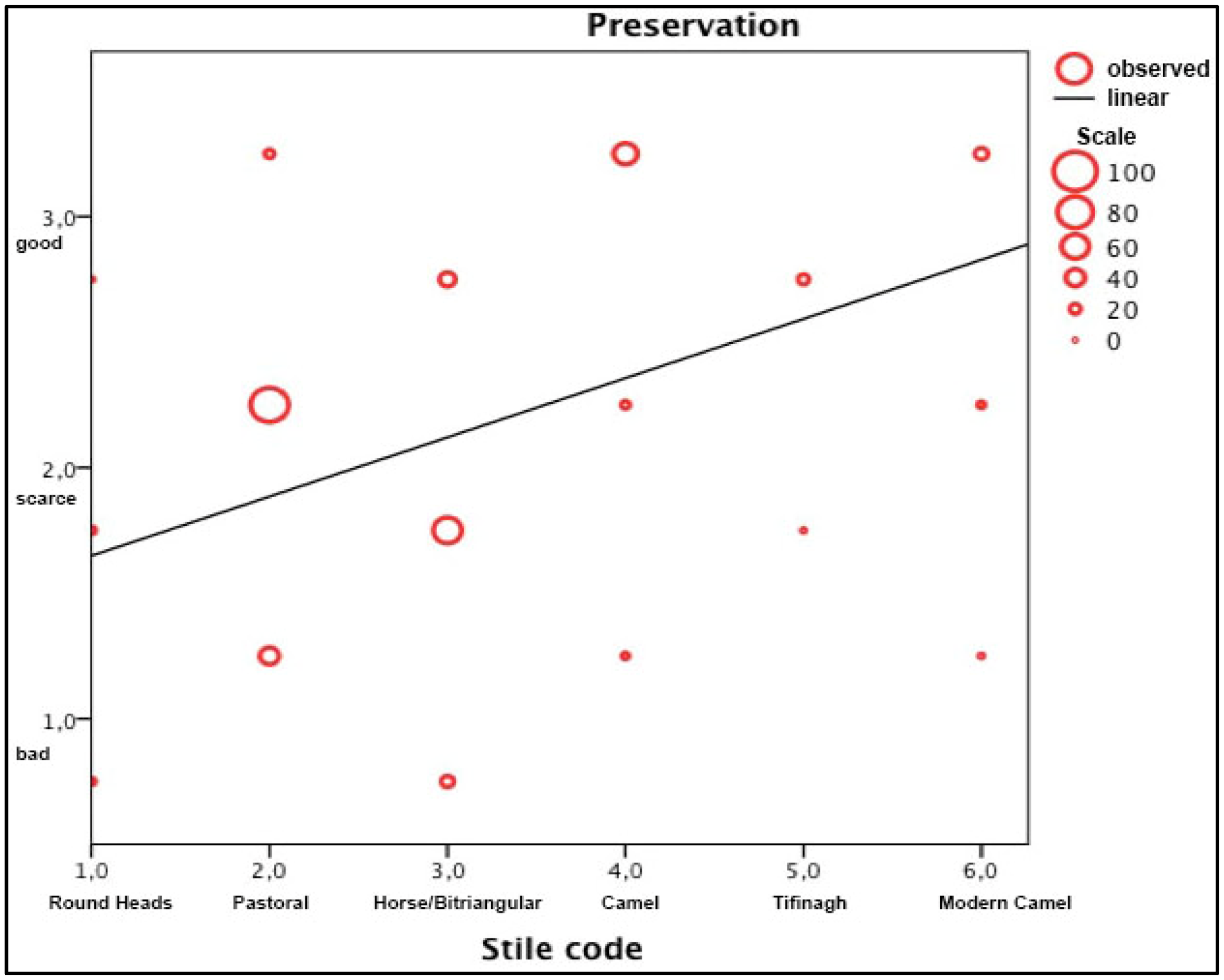
When one considers the style testimonies, a general high frequency of Pastoral figures can be observed, scoring more than 38%, followed by Tifinagh (ca. 17%), Camel (ca. 16%) and Horse/Bitriangular (ca 10%). Engravings are more represented than paintings, but for the Horse/Bitriangular and Round Heads style, where respectively ca. 94% and ca. 57% of testimonies are painted (Table 2). A similar trend is also observed for the relative quantity of artworks by style, where Round Heads and Horse/Bitriangular style contexts contain more scene/subjects than the other ones: ca. 63% of Round Heads testimonies have Medium or Abundant quantities of scenes, and the same applies for ca. 50% of Horse/Bitriangular testimonies. The state of preservation is strictly related to the technique: more than 73% of engravings have a good state of preservation, where the paintings are worse preserved, and the value of bad preservation increases in connection with the relative age of the style (Figure 11).
| Style | N° | Technique | Quantity | Significance | |||||||
|---|---|---|---|---|---|---|---|---|---|---|---|
| Engraving | Painting | Scarce | Average | Abundant | ND | Low | Medium | High | ND | ||
| Wild Fauna | 18 | 18 | 0 | 12 | 6 | 0 | 0 | 7 | 8 | 3 | 0 |
| 1.4% | 100.0% | 0% | 66.7% | 33.3% | 0% | 0% | 38.9% | 44.4% | 16.7% | 0% | |
| Round Heads | 54 | 23 | 31 | 18 | 26 | 8 | 2 | 12 | 6 | 35 | 1 |
| 4.1% | 42.6% | 57.4% | 33.3% | 48.1% | 14.8% | 3.7% | 22.2% | 11.1% | 64.8% | 1.9% | |
| Pastoral | 507 | 328 | 179 | 290 | 131 | 40 | 46 | 286 | 97 | 81 | 43 |
| 38.2% | 64.7% | 35.3% | 57.2% | 25.8% | 7.9% | 9.1% | 56.4% | 19.1% | 16.0% | 8.5% | |
| Horse/bitriangular | 137 | 7 | 130 | 65 | 57 | 11 | 4 | 72 | 30 | 31 | 4 |
| 10.3% | 5.1% | 94.9% | 47.4% | 41.6% | 8.0% | 2.9% | 52.6% | 21.9% | 22.6% | 2.9% | |
| Camel | 218 | 122 | 96 | 144 | 54 | 20 | 0 | 153 | 36 | 29 | 0 |
| 16.4% | 56.0% | 44.0% | 66.1% | 24.8% | 9.2% | 0% | 70.2% | 16.5% | 13.3% | 0% | |
| Modern Camel | 79 | 40 | 39 | 52 | 23 | 4 | 0 | 68 | 9 | 2 | 0 |
| 6.0% | 50.6% | 49.4% | 65.8% | 29.1% | 5.1% | 0% | 86.1% | 11.4% | 2.5% | 0% | |
| Tifinagh | 229 | 203 | 26 | 111 | 72 | 45 | 1 | 104 | 71 | 53 | 1 |
| 17.3% | 88.6% | 11.4% | 48.5% | 31.4% | 19.7% | 4% | 45.4% | 31.0% | 23.1% | 4% | |
| Arabic | 40 | 39 | 1 | 31 | 8 | 1 | 0 | 34 | 4 | 2 | 0 |
| 3.0% | 97.5% | 2.5% | 77.5% | 20.0% | 2.5% | 0% | 85.0% | 10.0% | 5.0% | 0% | |
| ND | 45 | 30 | 15 | 40 | 1 | 0 | 4 | 35 | 5 | 1 | 4 |
| 3.4% | 66.7% | 33.3% | 88.9% | 2.2% | 0% | 8.9% | 77.8% | 11.1% | 2.2% | 8.9% | |
| Total | 1327 | 810 | 517 | 763 | 378 | 129 | 57 | 771 | 266 | 237 | 53 |
| 100.0% | 61.0% | 39.0% | 57.5% | 28.5% | 9.7% | 4.3% | 58.1% | 20.0% | 17.9% | 4.0% | |
Figure 11.
Graph representing the quantitative relation between styles (sorted by relative age) and state of preservation; the linear trend shows the correlation between preservation and age.
Figure 11.
Graph representing the quantitative relation between styles (sorted by relative age) and state of preservation; the linear trend shows the correlation between preservation and age.

In approaching the data, one has to consider that the record gives us only a partial view of the real presence of ancient art, not only because of conservation issues but also as a consequence of some effects of the research carried out in the region. Several areas have not been properly surveyed, like the highest terraces, and probably there is an over-representation of certain wadi testimonies, as they are easier to access or they correspond to areas hosting real masterpieces, thence over-recorded. As the recent project about the Tifinagh outlined, specific research programs can still change our perspective on peculiar traits of the rock art heritage. However, looking at the distribution of sites and their characters, it is possible to identify some trends that partially overcome these limits and allow us to consider rock art in a wider environmental and archaeological context. In the present paper, observations are limited to a wide overview, based on the main characters of sites, but the development of the studies also on the specific ‘contents’ of sites will help to deepen the connections and help to insert the sites in a contextual analysis of past societies. In fact, while it is evident that the artworks bear an intrinsic value referring to the beliefs and ideological dynamics of past societies, at the same time they also have a tangible value, and they are an important element of the wider material culture, from which they cannot be separated.
‘Wild Fauna’ style, as referred in § 3.3 is the most problematic one. The long debate on its definition and its relative chronology has not been solved. Wild fauna style has been recorded in less than twenty sites, almost equally hosted in rockshelter or open-air sites (Figure 12a). Sites are mainly located in area 1 and area 3 and a main incidence occurs along Wadi Ajmir. The scarce presence of evidence in the Acacus area and the difficulty to clearly correlate the artwork with the archaeological data, urge to focus the research in two main directions: i. more efforts in indirect absolute dating; and ii. a more detailed sub-regional and regional study of the phenomenon. The sites here included show several characters that seem to confirm both to confirm the proper existence of this style and to suggest a greater antiquity than the other artistic evidence. Some of these characters are: a higher position on the supporting rock, implying a different floor elevation; the support, presence of carbonate crusts proving intensive later pluvial events; formation of dark patina.
‘Round Heads’ style is located all over the massifs, but for the western side, and with a minor frequency in the North. The sites are almost exclusively hosted in rockshelters and caves, mainly in high altitude physiographic units, but also along the eastern side of the massif. In the areas of higher incidence (Wadi Teshuinat and Wadi Afozzigiar) sites show significant clusters (Figure 12b). All these characters correspond to a deep knowledge of the landscape, with the use of even remote areas, and the concentration on locations that probably guaranteed a suitable stay. These characters fit well with the changes occurred in the settlement pattern and subsistence strategy of the Late Acacus groups, to which the style has been referred, characterized by a highly diversified subsistence strategy, including hunting, fishing and gathering, with ‘delayed-return’ strategies, and residential mobility [81], that correspond to a sound knowledge of the landscape. Other elements have been formerly proposed to sustain the attribution of the style to the cultural phase: the presence of grinding equipment or stones with remains of pigments from the Late Acacus levels of excavated contexts, both in the Wadi Teshuinat and Wadi Takarkori areas (Uan Tabu, Fozzigiaren, and Takarkori sites), and the presence of depicted subjects, clearly referable to the quoted subsistence strategies, like the correspondence between the Ammotragus exploitation and the presence of depicted Ammotragus (e.g., from Uan Afuda cave) or between the use of wild gathered cereals and the scene of gathering (e.g., from Afozzigiar II).
The high frequency of the ‘Pastoral style’ and its widespread diffusion, both reflect the intensity of the pastoral occupation, all over the massif, with major density along the wadi banks (Figure 12c). If one looks at the location of ‘Round Heads’ and ‘Pastoral’ images, it is possible to record a very high re-use of the same locations of the former period during the conspicuous Pastoral phase (Figure 13). This could mean that the experience of the landscape acquired during the Round Heads phase is shared by the Pastoral community, which anyway cluster mainly in specific areas of the wadis. The archaeological investigation carried out in the area allowed us to identify at least four different Pastoral phases spanning between 7400 and 2700 years BP and characterized by different patterns of occupation, subsistence strategies and material culture (e.g., [82,86]). A clear correlation between specific rock art sites with ‘Pastoral’ style and the different Pastoral cultural phases is still lacking, notwithstanding the proposals by Mori [6,30] and Muzzolini [15,102] or Le Quellec [16]. Anyway, as a recent work published for the adjacent Messak massif has remarked [3,10], the analytical interpretation of represented subjects and scenes and their comparison with archaeological features and data from excavations can still reveal exciting results for specific moments of the long Pastoral Neolithic phase: the analytical study of the imagery is still lagging behind. However, it is highly probable that the apex of the rock art testimonies referred to the ‘Pastoral’ style has to be set around the sixth millennium BP, corresponding with the Middle Pastoral culture; it is also probable that during the Late and Final Pastoral phases this style overlapped in use with the ‘Horse/Bitriangular’ one.
Figure 12.
Distributions of stylistic testimonies: (a) Wild Fauna. (b) Round Heads. (c) Pastoral. (d) Horse/Bitriangular. Site dots are distinguished by type: Open Air, Cave, Rockshelter.
Figure 12.
Distributions of stylistic testimonies: (a) Wild Fauna. (b) Round Heads. (c) Pastoral. (d) Horse/Bitriangular. Site dots are distinguished by type: Open Air, Cave, Rockshelter.

Rock art of ‘Horse/Bitriangular’ style is diffused all over the massifs, with a major presence in the southern areas (Area 4—where a particular incidence is visible all over the course of Wadi Senaddar—and Area 5) where it occurs only inside rock shelters (Figure 12d). About 50% of the location hosting Horse/Bitriangular artworks have already been exploited for Pastoral art; therefore, there is a consistent continuity even if the total number of sites is heavily reduced (Figure 13). As remarked before, the sites are characterized by a general high number of subjects and more than 44% of sites show high or medium significance, thanks to the presence of complex scenes or images, including specific new subjects, like oasis representation, flying gallop chariots or fight scenes. The contextual analysis of these sites could help to deepen the comprehension of socio-cultural changes that occurred during the final stages of the Pastoral Neolithic occupation of the massifs and the emergence of the early Garamantian culture. When the climatic and paleoenvironmental conditions collapsed, the pastoral groups still use the massif on a seasonal basis, for penning activity, as remarked by the presence of dung deposits in several rock shelters, and of fixed semi-permanent camps in the Wadi Tanezzuft area -the wide wadi bordering the western side of the Acacus escarpment, that became a large oasis [62,103]. Archaeological data from settlements and, above all, burials reveal not only a change in the subsistence strategy but also suggest the emergence of social stratification that will probably end in the first Garamantian state [85,86]. Both changes seem to have a clear correspondence in rock art, mainly in the representation of the herders and their accessories.
Figure 13.
Quantity of rock art testimonies by style/phase, showing the continuity in use of sites from one style/phase to the others.
Figure 13.
Quantity of rock art testimonies by style/phase, showing the continuity in use of sites from one style/phase to the others.

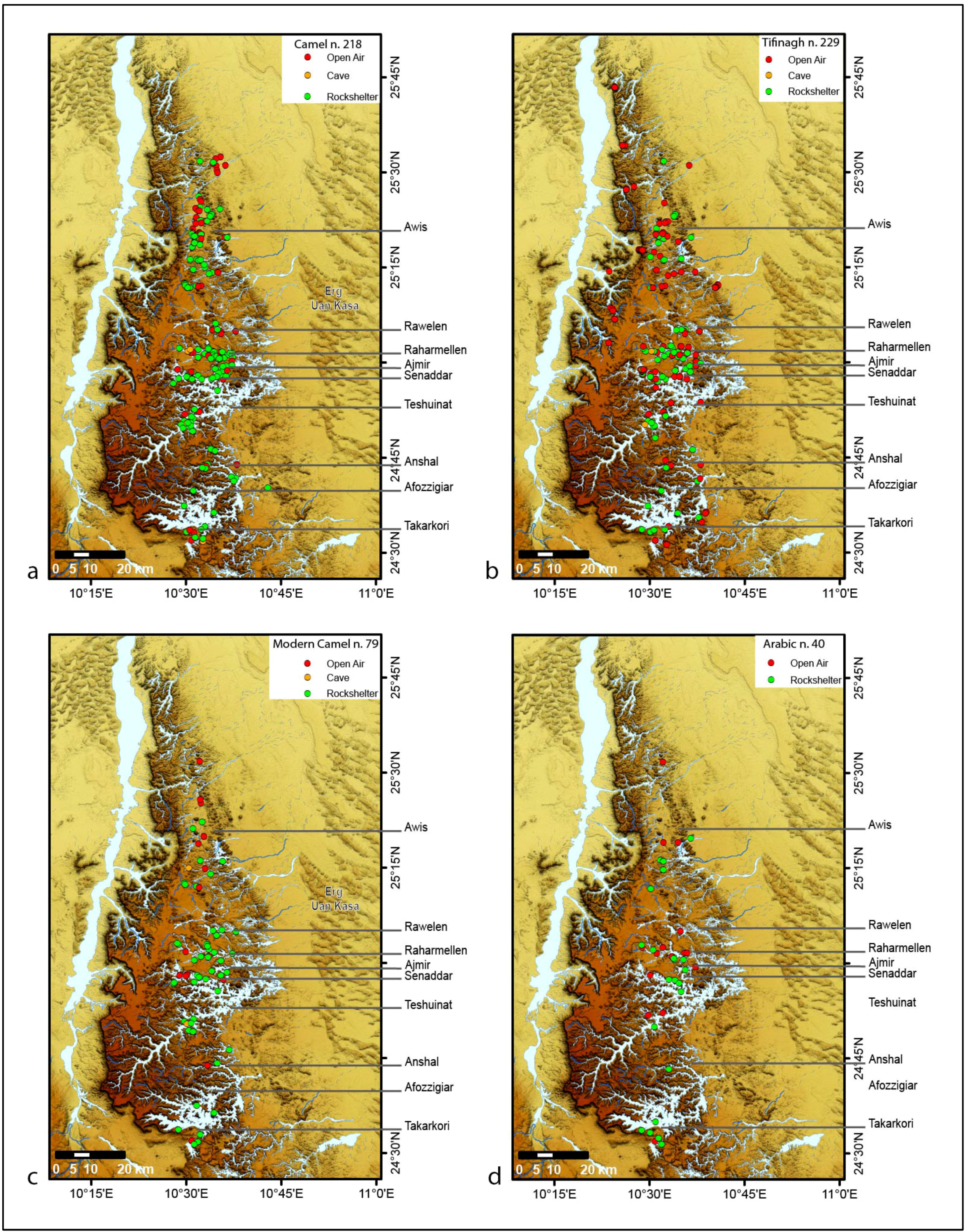
Camel—with Pastoral and Tifinagh—is one of the best represented styles in the massifs. If we look at the data from a different perspective, and if we calculate the density of style testimonies per year for the time span of the single cultural phases, the figures change a bit and Camel style becomes the most represented style, mainly in Areas 2 and 3 (Figure 14a). As we remarked before, this style has been traditionally related to the classic and final phases of Garamantian culture (III BCE – VI CE), a historical period scarcely known in the Acacus. The use of this style could overlap with the previous phases of formative Garamantian culture, and can also include representations dating to the Islamic period. This density value is useful, in order to highlight the fact that a relevant portion of the rock art heritage has been left behind, which, if analyzed with an integrated approach, could help to fix some uncertainties about the historic occupation of the massif. As noted in § 3.2, the archaeological data referable to this period mainly come from contexts located outside the massif, whereas few data are available from the Acacus, from dung deposits located in Wadi Teshuinat (Uan Muhuggiag and Uan Amil) and from the recent investigation of the etaghas and gueltas contexts [60]. In this period, it has been suggested that the massif was crossed as part of a wide caravan trade network [17,90]. However, the distribution of rock art sites with Camel evidence is not exclusive of the northern part of the Awiss area, where the main passageways indicated as a local node in the caravan route of the trans-Saharan trade networks are located [104], but they are also spread along the course of the main wadis, where the rockshelters were probably still in use for penning activities. Dung deposits, gueltas and etaghas support a ‘pastoral’ use of the massif and a more ‘stable’ occupation also of the mountain, as well.
The same distribution trend can be envisaged with the ‘Tifinagh’ writings, but for the sites located in correspondence of the passageways, both on the western escarpment and on the easternmost side of the massif (Figure 14b). As widely discussed [76], the presence of Tifinagh inscription also in central areas highlights potential paths of interest other than those suggested by Liverani’s reconstruction, namely, of the network of past caravan roads crossing the Acacus Mountains ([17]: 453). On the basis of the known distribution of Tifinagh inscriptions, a possible presence of other paths, crossing other sections of the Acacus Mountains, could be suggested and a more ‘stable’ use of the massifs has been proposed by Biagetti and colleagues [76] which fits well with data available for the etaghas, especially for the Ti-n-Lalan area [60].
As outlined in § 3.3, the definition of the Modern Camel style is still in an embryonic stage, and it has not been discussed in detail; however, the widespread distribution of sites (Figure 14c), often related to residual traces of modern encampments, fits well with the recent reconstruction of the Tuareg settlement pattern [75]. A similar distribution is shared by the Arabic writings (Figure 14d): it is probable that the two evidences are correlated. It is noteworthy to quote the traditional well of Sughd (locally named Bir Sughd), where an impressive quantity of Tifinagh and Arabic writings, showing different patina, is present. This site is a historical witness of extraordinary relevance ([60]: 117).
Figure 14.
Distributions of stylistic testimonies: (a) Camel, (b) Tifinagh, (c) Modern Camel, (d) Islamic. Site dots are distinguished by type: Open Air, Cave, Rockshelter.
Figure 14.
Distributions of stylistic testimonies: (a) Camel, (b) Tifinagh, (c) Modern Camel, (d) Islamic. Site dots are distinguished by type: Open Air, Cave, Rockshelter.

4. Conclusion
Methods and aims of the rock art study in the Sahara massifs attained great results immediately after its discovery, ending in an early use of scientific methods and wide syntheses. Afterwards, the debate often followed diverging paths, characterized by heated debates, piecemeal approaches, and a limited use of analytical methods and technologies. However, recent years have been characterized by two renewed principal approaches that seem to envisage a new season of research.
On one side, the attempts of precise absolute dating of artworks, widely applied in other parts of the world [105,106], seem to open new perspectives for chronological definition. In fact, while the radiocarbon direct dating of paintings repeatedly failed both in Acacus and Tassili massifs, because of sample degradation and pollution [10,32,57], indirect OSL dating of sediments covering the artworks (in Tassili and in the northern context of Qurta) seems to give more reliable data, giving older results, nonetheless with a wide standard error, which are more coherent with a traditional higher chronology and long developmental sequence [8,9].
On the other hand, studies firmly based on contexts and territories of the rock art -allowing to deepen the understanding of the occupation history and of the social dynamics of a region were the first to obtain significant results [3,10,11,107]. The analyses proposed in the present paper give a general overview of artistic data at a regional scale. In order to represent the complexity and the extreme variability of rock art of the Acacus it has been decided to discuss all the recorded different styles. Some general remarks can be highlighted: i. distribution patterns do not clearly fit between areas with similar geomorphological features; ii. a high incidence of Round Heads style is recorded in high altitude physiographic units, as well as the presence of significant clusters of sites, on specific wadis in the southernmost area of the massif; iii. a consistent ‘re-use’ of sites with ‘Pastoral’ artworks took place in the ‘Horse/Bitriangular’ style, with a more selective distribution of sites in only some wadis (e.g., the widespread presence all over Wadi Senaddar in area 4). These choices do not correlate exclusively with environmental and geomorphological characters and need to be investigated in major detail. A systematic approach is needed, checking the occurrence of repeated attributes in the physiographic characteristics of sites (e.g., size, exposition, accessibility), and the contextual co-presence of specific archaeological features and artworks, extending the study to specific scenes and subjects. This step is still to be made, and it is necessary, in order to investigate the nature of rock art contexts, i.e., whether we should consider them as a simple by-product of human occupation, with artworks directly correlated to the intensity of local anthropic use, or if a specific-ritual use of certain areas or sites of the massif can be envisaged, with artistic activity not directly correlated with anthropic intensity of use, as it has been, for example, suggested for the nearby Messak massif [3,10].
Furthermore, a systematic integrated study of rock art (including a comprehensive classificatory, quantitative and semiotic reading) is necessary to define cultural local dynamics that, compared in a wider regional perspective, can underline possible roots or paths of shared cultural traits.
The Acacus is an ideal context to develop these analyses, for the richness and variability of artworks, as well as for the huge archaeological data known, but also for its proximity to other important areas with rock art: Tassili n’Ajjer, Algerian Tadrart and Messak massifs. While a common shared cultural tradition has been recurrently suggested, even if several differences have been deduced (e.g., [15]: in particular between Acacus and Tassili artworks), sounder results could stem from the huge amount of now available data, if properly re-analyzed thanks to the use of advanced methodologies.
Acknowledgments
This research is part of the activities of the Archaeological Mission in the Sahara, Sapienza-University of Rome, directed by Savino di Lernia. I wish to thank Dr Saleh Al-Raghb, Chairman of the Department of Archaeology, Tripoli, and Mr Saad Abdul Aziz, Controller of Sebha Department and all our Libyan colleagues. Particular thanks to Daniela Zampetti, responsible of the rock art team from 2001 to 2009, and her team over the years: Stefano Biagetti, Sara Giovannetti, Chiara Pizzi, Francesca Del Fattore. To Savino di Lernia my warmest thanks for his help, support and comments on the manuscript. I also thank Mauro Cremaschi, Alessandro Perego, Andrea Zerboni for their work on the Tadrart Acacus geology, and Stefano Biagetti, Lucia Mori and Alessandro Vanzetti for discussion and comments on the manuscript. I wish to thank warmly the editors and the reviewers, for their comments and useful remarks. Remaining errors are mine. Photo credits: Photo © The Italian Archaeological Mission in the Sahara.
Conflict of Interest
The author declare no conflict of interest.
References and Notes
- Throughout the text, the quotation ‘BP’ refers to uncalibrated years before present, according to Libby’s half-life.
- R. Kuper, and S. Kröpelin. “Climate-controlled Holocene occupation in the Sahara: Motor of Africa's evolution.” Science 313 (2006): 803–807. [Google Scholar] [CrossRef]
- M. Cremaschi, and S. di Lernia. Wadi Teshuinat. Palaeoenvironment and prehistory in south-western Fezzan (Libyan Sahara). Milano and Firenze: CNR and All'Insegna del Giglio, 1998. [Google Scholar]
- S. di Lernia, M.A. Tafuri, M. Gallinaro, F. Alhaique, M. Balasse, L. Cavorsi, P.D. Fullagar, A.M. Mercuri, A. Monaco, and A. Perego. “Inside the “African Cattle Complex”: Animal burials in the Holocene central Sahara.” PLoS ONE 8 (2013): e56879. [Google Scholar] [CrossRef] [Green Version]
- J. Dunne, R. Evershed, M. Salque, L. Cramp, S. Bruni, K. Ryan, S. Biagetti, and S. di Lernia. “First dairying in 'green' Saharan Africa in the 5th millennium bc.” Nature 486 (2012): 390–394. [Google Scholar] [CrossRef]
- F. Wendorf, and R. Schild. Holocene settlement of the Egyptian Sahara. New York: Kluwer Academic / Plenum Publishers, 2001. [Google Scholar]
- F. Mori. Tadrart Acacus. Arte rupestre e culture del Sahara preistorico. Torino: Einaudi, 1965. [Google Scholar]
- H. Lhote. Vers d’autres Tassili. Nouvelles découvertes au Sahara. Paris: Arthaud, 1976. [Google Scholar]
- D. Huyge, D.A.G. Vandenberghe, M. De Dapper, F. Mees, W. Claes, and J.C. Darnell. “First evidence of Pleistocene rock art in north Africa: Securing the age of the Qurta petroglyphs (Egypt) through OSL dating.” Antiquity 85 (2011): 1184–1193. [Google Scholar]
- N. Mercier, J.-L. Le Quellec, M. Hachid, S. Agsous, and M. Grenet. “OSL dating of quaternary deposits associated with the parietal art of the Tassili-n-Ajjer plateau (central Sahara).” Quaternary Geochronology 10 (2012): 367–373. [Google Scholar] [CrossRef]
- S. di Lernia, and M. Gallinaro. “The date and context of neolithic rock art in the Sahara: Engravings and ceremonial monuments from Messak Settafet (south-west Libya).” Antiquity 84 (2010): 954–975. [Google Scholar]
- R. Kuper. Wadi Sura: The cave of beasts; a rock art site in the Gilf Kebir (SW-Egypt). Köln: Heinrich-Barth-Institut, 2013. [Google Scholar]
- H. Barth. Reisen und Entdeckungen in nord und central Africa in den Jahren 1849 bis 1855 (5 vols.). Gotha: Justus Perthes. pp. 1857–1858.
- G.B.M. Flamand. Les pierres écrites (Hadjrat- maktoubat): Gravures et inscriptions rupestres du nord Africain. Paris, 1921. [Google Scholar]
- Archaeology and environment in the Libyan Sahara. The excavations in the Tadrart Acacus, 1978–1983. B.E. Barich, ed. Oxford: BAR, 1987, Vol. BAR 368.
- A. Muzzolini. Les images rupestres du Sahara. Toulouse: Ed. par l'auteur, 1995. [Google Scholar]
- J.L. Le Quellec. Art rupestre et préhistorie du Sahara. Le Messak Libyen. Paris: Bibliotheque Scientifique Payot, 1998. [Google Scholar]
- M. Liverani. Aghram Nadharif. The Barkat Oasis (sha 'abiya of Ghat, Libyan Sahara) in Garamantian times. Firenze: All'Insegna del Giglio, 2005, Vol. 5. [Google Scholar]
- Y. Tschudi. Les peintures rupestres du Tassili-n-Ajjer. Neuchatel: La Baconnière, 1956. [Google Scholar]
- H. Lhote. Á la découverte des fresques du Tassili. Paris: Arthaud, 1958. [Google Scholar]
- F. Mori. “Ricerche paletnologiche nel Fezzan.” Rivista di Scienze Preistoriche XI (1956): 211–229. [Google Scholar]
- F. Mori. Arte preistorica del Sahara libico. Roma: De Luca, 1960. [Google Scholar]
- La memoria dell'arte. Le pitture rupestri dell'Acacus tra passato e futuro. S. di Lernia, and D. Zampetti, eds. Rome and Tripoli: All'insegna del Giglio, 2008.
- J. Keenan. “The lesser gods of the Sahara.” Journal of Public Archaeology 2 (2002): 131–150. [Google Scholar] [CrossRef]
- J.D. Lajoux. Art rupestre et aventures. In Hic sunt leones. Mélanges sahariens en l’honneur d’Alfred Muzzolini. Edited by Y. Gauthier, J-L. Le Quellec and R. Simonis. 2006, Vol. Cahiers de l'AARS, pp. 127–148. [Google Scholar]
- P. Bahn. Prehistoric rock art: Polemics and progress. Cambridge: Cambridge University Press, 2010. [Google Scholar]
- P. Bahn. “North Africa’s place in rock art research.” In The Signs of Which Times? Chronological and Palaeoenvironmental Issues in the Rock Art of Northern Africa, Bruxelles, 2010. Edited by D. Huyge, F. Van Noten and D. Swinne. Bruxelles: Royal Academy for Overseas Sciences, 2012, pp. 7–25. [Google Scholar]
- S. di Lernia, and M. Gallinaro. “The rock art of the Acacus Mts. (SW Libya), between originals and copies.” Sahara 20 (2009): 13–30. [Google Scholar]
- Arte preistorica del Sahara. B.E. Barich, E. Garcea, M. Lupacciolu, and R. Sebastiani, eds. Roma, Milano: De Luca, Mondadori, 1986.
- Arte e culture del Sahara preistorico. M. Lupacciolu, ed. Roma: Quasar, 1992.
- F. Mori. The great civilisations of the ancient Sahara. Rome: L'Erma di Bretschneider, 1998. [Google Scholar]
- F. Mori. “Figure umane incise di tipo ittiomorfo scoperte nel Tadrart Acacus.” Origini 1 (1967): 37–51. [Google Scholar]
- M. Hachid, J.-L. Le Quellec, A. Amara, L. Beck, E. Kaltnecker, S. Merzoug, A. Quiles, and H. Valladas. “Quelques résultats du projet de datation directe et indirecte de l’art rupestre Saharien.” In The Signs of Which Times? Chronological and Palaeoenvironmental Issues in the Rock Art of Northern Africa, Bruxelles, 2010. Edited by D. Huyge, F. Van Noten and D. Swinne. Bruxelles: Royal Academy for Overseas Sciences, 2012, pp. 71–96. [Google Scholar]
- S. di Lernia. “Cultural landscape and local knowledge: A new vision of Saharan archaeology.” Libyan Studies, 2006, 37. [Google Scholar]
- G. Aumassip, and G. Delibrias. “Ages des depots neolithiques du gisement de Ti-n-Hanakaten (Tassili-n-Ajjer. Algérie).” Libyca XXX–XXXI (1982–1983): 207–211. [Google Scholar]
- G. Aumassip. “Le néolithique en Algérie: État de la question.” L'Anthropologie 91 (1987): 585–622. [Google Scholar]
- M. Hachid. “Le Tassili des Ajjer: Aux sources de l’Afrique, 50 siècles avant les pyramides.” Paris: EDIF 2000/Paris Méditerranée, 1998. [Google Scholar]
- “Collectif Actes du séminaire international sur la conservation des peintures rupestres du tassili.” In Séminaire international sur la Conservation des peintures rupestres du Tassili Alger, 21–30 octobre 1978; Alger: Office du Parc National du Tassili, 1978.
- J. Brunet, S. Demailly, and P. Vidal. Etude de prélèvements de peintures rupestres du Tassili n'Ajjer (Algerie). Paris: ICOM, 1984. [Google Scholar]
- J. Brunet, P. Vidal, and J. Vouvé. Exemple d’étude de l’environnement climatique et pictural appliquée aux abris sous roche en milieu désertique. Cas du Tassili n’Ajjer. Edited by UNESCO. 1985, pp. 67–125. [Google Scholar]
- J. Brunet, S. Demailly, and P. Vidal. “Résultats de l’étude de prélèvements de peintures des abris du Tassili n’Ajjer.” Ars Praestorica VII/VIII (1988–1989): 293–303. [Google Scholar]
- A. Van Albada, and A.M. Van Albada. La Montagne des Hommes-Chiens. Art rupestre du Messak libyen. Paris: Seuil, 2000. [Google Scholar]
- G. Aumassip. Chronologies de l'art rupestre Saharien et nord Africain. Paris: Editions J. Gandini, 1993. [Google Scholar]
- K.H. Striedter. “L’âge de l’art rupestre du Sahara algérien.” In L’Algérie en héritage. Paris: Art et histoire., Ed. Paris, 2003, pp. 60–69. [Google Scholar]
- A. Muzzolini. “Proposals for updating the rock-drawing sequence of the Acacus.” Libyan Studies 22 (1991): 7–30. [Google Scholar]
- The Uan Afuda Cave. Hunter gatherer societies of central Sahara. S. di Lernia, ed. Firenze: All’Insegna del Giglio, 1999.
- Uan Tabu in the settlement history of Libyan Sahara. E.A.A. Garcea, ed. Firenze: All’Insegna del Giglio, 2001.
- U. Sansoni. Le più antiche pitture del Sahara. L’arte delle Teste Rotonde. Milano: Jaca Book, 1994. [Google Scholar]
- J.L. Le Quellec. Symbolisme et art rupestre au Sahara. Paris: L'Harmattan, 1993. [Google Scholar]
- K.H. Striedter. Felsbilder Nordafrikas und der Sahara Studien zur Kulturkunde. Wiesbaden, 1983, Vol. 64. [Google Scholar]
- A.B. Smith. “New approaches to Saharan rock art.” In L’Arte e l’Ambiente del Sahara Preistorico: Dati e Interpretazioni, Milano, 24–27 ottobre 1990 1993. Edited by G. Calegari. Milano: Società italiana di scienze naturali e Museo civico di storia naturale di Milano. pp. 466–478.
- A. Holl. “Pathways to elderhood: Research on pastoral iconography, the paintings from Tikadiouine (Tassili-n-Ajjer).” Origini 18 (1995): 69–113. [Google Scholar]
- A. Holl. Saharan rock art: Archaeology of Tassilian pastoralist iconography. Lanham: Rowman & Littlefield, 2004. [Google Scholar]
- M. Cremaschi, D. Zampetti, and A. Zerboni. “Different paths: Rock art, sites and territories in Wadi Raharmellen (Tadrart Acacus- Libyan Sahara).” Origini 27 (2005): 191–217. [Google Scholar]
- D. Zampetti. “Le nuove ricerche sull'arte rupestre dell'Acacus: Il senso del paesaggio, il senso della figura.” In La memoria dell'arte. Le pitture rupestri dell'Acacus tra passato e futuro. Edited by S. di Lernia and D. Zampetti. Firenze: All'Insegna del Giglio, 2008, pp. 339–349. [Google Scholar]
- S. di Lernia, and M. Gallinaro. “Working in a UNESCO WH site. Problems and practices on the rock art of the Tadrart Acacus (SW Libya, central Sahara).” Journal of African Archaeology 9 (2011): 159–175. [Google Scholar] [CrossRef]
- M. Hachid, J.-L. Le Quellec, S. Agsous, A. Amara, L. Beck, F. Duquesnoy, M. Grenet, A. Heddouche, E. Kaltnecker, N. Mercier, and et al. “Premiers résultats du projet algéro-français de datation directe et indirecte des images rupestres dans la Tasili-n-Ajjer.” Sahara 21 (2010): 27–58. [Google Scholar]
- A. Zerboni. “Rock art from the central Sahara (Libya): A geoarchaeological and palaeoenvironmental perspective.” In The Signs of Which Times? Chronological and Palaeoenvironmental Issues in the Rock Art of Northern Africa, Bruxelles, 2010. Edited by D. Huyge, F. Van Noten and D. Swinne. Bruxelles: Royal Academy for Overseas Sciences, 2012, pp. 175–195. [Google Scholar]
- M. Sinibaldi, S. Marchese, and C. Desiderio. “Radiocarbon dates of prehistoric rock paintings at Tadrart Acacus, Libya.” In XIII International Congress of Prehistoric and Protohistoric Sciences, Forlì, 1996. Edited by G. Aumassip, J.D. Clark and F. Mori. Forlì: A.B.A.C.O., 1996. [Google Scholar]
- F. Mori, R. Ponti, A. Messina, M. Flieger, V. Havlicek, and M. Sinibaldi. “Chemical characterization and AMS radiocarbon dating of the binder of a prehistoric rock pictograph at Tadrart Acacus, southern west Libya.” Journal of Cultural Heritage 7 (2006): 344–349. [Google Scholar] [CrossRef]
- S. di Lernia, I. Massamba N'Siala, and A. Zerboni. “‘Saharan Waterscapes’. Traditional knowledge and historical depth of water management in the Akakus Mts. (SW Libya).” In Changing deserts: Integrating people and their environment. Edited by L. Mol and T. Sternberg. Cambridge: The White Horse Press, 2012, pp. 101–128. [Google Scholar]
- M. Cremaschi. “Late quaternary geological evidence for environmental changes in south-western Fezzan (Libyan Sahara).” In Wadi Teshuinat - palaeoenvironment and prehistory in south-western Fezzan (Libyan Sahara). Edited by M. Cremaschi and S. di Lernia. Roma-Milano: CNR, 1998, pp. 13–47. [Google Scholar]
- M. Cremaschi, and A. Zerboni. “Human communities in a drying landscape. Holocene climate change and cultural response in the central Sahara.” In Landscape and Societies. Edited by I.P. Martini and W. Chesworth. Heidelberg, London, New York: Springer Dordrecht, 2011, pp. 67–89. [Google Scholar]
- A. Fantoli. “Clima.” In Il Sahara italiano. Roma: Reale Società Geografica Italiana, Società Italiana Arti Grafiche, 1937, pp. 97–119. [Google Scholar]
- H. Walther, and H. Lieth. Klimadiagramm-Weltatlas. Jena: G. Fischer Verlag, 1960. [Google Scholar]
- C.V. Haynes Jr. “Geochronology and climate change of the Pleistocene-Holocene transition in the Darb el Arba'in Desert, Eastern Sahara.” Geoarchaeology - An International Journal 16 (2001): 119–141. [Google Scholar] [CrossRef]
- M. Cremaschi, and L. Trombino. “The palaeoclimatic significance of the paleosols in southern Fezzan (Libyan Sahara): Morphological and micromorphological aspects.” Catena 34 (1998): 131–156. [Google Scholar] [CrossRef]
- P. DeMenocal, J. Ortiz, T. Guilderson, J. Adkins, M. Sarnthein, L. Baker, and M. Yarusinsky. “Abrupt onset and termination of the African Humid period: Rapid climate responses to gradual insolation forcing.” Quaternary Science Reviews 19 (2000): 347–361. [Google Scholar] [CrossRef]
- F. Gasse. “Hydrological changes in the African tropics since the last glacial maximum.” Quaternary Science Reviews 19 (2000): 189–211. [Google Scholar] [CrossRef]
- P. Hoelzmann, F. Gasse, L.M. Dupont, U. Salzmann, M. Staubwasser, D.C. Leuschner, and F. Sirocko. “Palaeoenvironmental changes in the arid and subarid belt (Sahara-Sahel-Arabian peninsula) from 150 kyr to present.” Past Climate Variability Through Europe and Africa, 2004, 219–256. [Google Scholar]
- S. Kröpelin, D. Verschuren, A.M. Lézine, H. Eggermont, C. Cocquyt, P. Francus, J.P. Cazet, M. Fagot, B. Rumes, and J.M. Russell. “Climate-driven ecosystem succession in the Sahara: The past 6000 years.” Science 320 (2008): 765–768. [Google Scholar] [CrossRef]
- J. Maley. “Climate and palaeoenvironment evolution in north tropical Africa from the end of the Tertiary to the upper Quaternary.” Palaeoecology of Africa 30 (2010): 227–278. [Google Scholar]
- A.M. Mercuri. “Human influence, plant landscape evolution and climate inferences from the archaeobotanical records of the Wadi Teshuinat area (Libyan Sahara).” Journal of Arid Environments 72 (2008): 1950–1967. [Google Scholar] [CrossRef]
- S. di Lernia. “Dry climatic events and cultural trajectories: Adjusting middle Holocene pastoral economy of the Libyan Sahara.” In Droughts, food and culture. Edited by F. Hassan. New York: Kluver Academic/Plenum Publisher, 2002, pp. 225–250. [Google Scholar]
- A. Gautier. “The archaeozoological sequence of the Acacus.” In Archaeology and environment in the Libyan Sahara. The excavations in the Tadrart Acacus, 1978–1983. Edited by B.E. Barich. Oxford: BAR, 1987, Vol. BAR 368, pp. 283–312. [Google Scholar]
- S. Biagetti, and J.M. Chalcraft. “Imagining aridity: Human-environment interactions in the Acacus mountains, south-west Libya.” In Imagining landscapes: Past, present, and future. Edited by M. Janowski and T. Ingold. Farnham: Asghate, 2012, pp. 77–95. [Google Scholar]
- S. Biagetti, A. Ait Kaci, L. Mori, and S. di Lernia. “Writing the desert. The ‘tifinagh’ rock inscriptions of the Tadrart Acacus (south-west Libya).” Azania 47 (2012): 153–174. [Google Scholar] [CrossRef]
- S. Biagetti, and S. di Lernia. “Holocene fillings of Saharan rock shelters: The case of Takarkori and other sites from the Tadrart Acacus mts. (SW Libya).” African Archaeological Review 30 (2013): 305–328. [Google Scholar] [CrossRef]
- E. Cancellieri, and S. di Lernia. “Re-entering the central Sahara at the onset of the Holocene: A territorial approach to early acacus hunter–gatherers (SW Libya).” Quaternary International.
- C. Corridi. “Faunal remains from Holocene archaeological sites of the Tadrart Acacus and surroundings.” In Wadi Teshuinat. Palaeoenvironment and prehistory in south-western Fezzan (Libyan Sahara). Edited by M. Cremaschi and S. di Lernia. Milano: CNR, 1998, pp. 89–94. [Google Scholar]
- S. di Lernia. “Early Holocene pre-pastoral cultures in the Uan Afuda Cave, Wadi Kessan, Tadrart Acacus (Libyan Sahara).” In Wadi Teshuinat. Palaeoenvironment and prehistory in south-western Fezzan (Libyan Sahara). Edited by M. Cremaschi and S. di Lernia. Milano: CNR, 1998. [Google Scholar]
- S. di Lernia. “Dismantling dung: Delayed use of food resources among early Holocene foragers of the Libyan Sahara.” Journal of Anthropological Archaeology 20 (2001): 408–441. [Google Scholar] [CrossRef]
- M. Cremaschi, and S. di Lernia. “Holocene climatic changes and cultural dynamics in the Libyan Sahara.” African Archaeological Review 16 (1999): 211–238. [Google Scholar] [CrossRef]
- S. Biagetti, and S. di Lernia. “Reflections on the Takarkori rockshelter (Fezzan, Libyan Sahara).” In On shelter’s ledge: Histories, theories and methods of rockshelter research. XV world congress UISPP, Lisbon. Edited by M. Kornfeld, S. Vasil’ev and L. Miotti. Oxford: Archaeopress, 2007, Vol. BAR S1655, pp. 125–132. [Google Scholar]
- A. Pasa, and M.V. Pasa Durante. “Analisi paleoclimatiche nel deposito di Uan Muhuggiag, nel massiccio dell'Acacus (Fezzan meridionale).” Memorie Museo Civico di Storia Naturale di Verona 10 (1962): 251–255. [Google Scholar]
- S. di Lernia, G. Manzi, and F. Merighi. “Cultural variability and human trajectories in later prehistory of the Wadi Tanezzuft.” In Sands, stones and bones. The archaeology of death in the Wadi Tanezzuft Valley (5000–2000 bp). Edited by S. di Lernia and G. Manzi. Firenze: All'Insegna del Giglio, 2002, pp. 281–302. [Google Scholar]
- S. di Lernia, and F. Merighi. “Transitions in the later prehistory of the Libyan Sahara, seen from the Acacus mountains.” In The Libyan Desert: Natural resources and cultural heritage. Edited by D. Mattingly, S. McLaren, E. Savage, Y. al-Fasatwi and K. Gadgood. London: The Society for Libyan Studies, 2006, pp. 111–122. [Google Scholar]
- D. Mattingly. The archaeology of Fazzan. London: Department of Antiquities, Tripoli; Society for Libyan Studies, 2003, Vol. 1. [Google Scholar]
- R. Castelli, M.C. Gatto, M. Cremaschi, M. Liverani, and L. Mori. “A preliminary report of excavations in Fewet, Libyan Sahara.” Journal of African Archaeology 3 (2005): 69–102. [Google Scholar] [CrossRef]
- L. Mori. Life and death of a rural village in Garamantian times. Archaeological investigations in the Fewet Oasis (Libyan Sahara). Firenze: All'Insegna del Giglio, forthcoming.
- S. Biagetti, and S. di Lernia. “Combining intensive field survey and digital technologies: New data on the Garamantian castles of Wadi Awiss, Acacus mts., Libyan Sahara.” Journal of African Archaeology 6 (2008): 57–85. [Google Scholar] [CrossRef]
- M.F. Pazdur. “Evaluation of radiocarbon dates of organic samples from Uan Muhuggiag and Ti-n-Torha, southwestern Libya.” In Environmental change and human culture in the Nile Basin and Northern Africa until the second millenium BC, Poznan 1988. Edited by L. Krzyzaniak, M. Kobusiewicz and J. Alexander. Poznan: Poznan Archaeological Museum, 1993, pp. 43–47. [Google Scholar]
- M. Cremaschi, and S. di Lernia. “The geoarchaeological survey in the central Tadrart Acacus and surroundings (Libyan Sahara). Environment and cultures.” In Wadi Teshuinat. Palaeoenvironment and prehistory in south-western Fezzan (Libyan Sahara). Edited by M. Cremaschi and S. di Lernia. Milano and Firenze: CNR and All'Insegna del Giglio, 1998, pp. 243–296. [Google Scholar]
- M. Cremaschi. “The rock varnish in the Messak Settafet (Fezzan, Libyan Sahara), age, archaeological context, and paleo-environmental implication.” Geoarchaeology 11 (1996): 393–421. [Google Scholar] [CrossRef]
- A. Zerboni. “Holocene rock varnish on the Messak Plateau (Libyan Sahara): Chronology of weathering processes.” Geomorphology 102 (2008): 640–651. [Google Scholar] [CrossRef]
- L. Barham, and P. Mitchell. The first Africans. Cambridge: Cambridge University Press, 2008. [Google Scholar]
- J. Soukopova. Round Heads: The earliest rock paintings in the Sahara. Cambridge: Cambridge University Press, 2012. [Google Scholar]
- F. Soleihavoup. L’art mystérieux des Têtes Rondes au Sahara. Paris: Faton, 2007. [Google Scholar]
- J. Choppy, B. Choppy, J.L. Le Quellec, S. Scarpa Falce, and A. Scarpa Falce. Images rupestres en Libye, Aouis. Paris, 2002. [Google Scholar]
- Handbook of rock art research. D.S. Whitley, ed. Walnut Creek: AltaMira Press, 2001.
- The figured landscapes of rockart: looking at pictures in place. C. Chippindale, and G. Nash, eds. Cambridge: Cambridge. University Press, 2004.
- A Companion to rock art. J. McDonald, and P. Veth, eds. Malden: Wiley Blackwell, 2012.
- A. Muzzolini. “Saharan Africa.” In Handbook of rock art research. Edited by D.S. Whitley. Walnut Creek: AltaMira Press, 2001, pp. 605–636. [Google Scholar]
- M. Cremaschi. “Holocene climatic changes in an archaeological landscape: The case study of Wadi Tanezzuft and its drainage basin (SW Fezzan, Libyan Sahara).” Libyan Studies 32 (2001): 3–27. [Google Scholar]
- M. Liverani. “The trans-Saharan caravan trade.” In Aghram Nadharif: The Barkat Oasis (shabiya of Ghat, Libyan Sahara) in Garamantian times. Edited by M. Liverani. Firenze: All’Insegna del Giglio, 2005, pp. 445–456. [Google Scholar]
- R.G. Bednarik. “The dating of rock art: A critique.” Journal of Archaeological Science 29 (2002): 1213–1233. [Google Scholar] [CrossRef]
- K. Steelman, and M.W. Howe. “Radiocarbon dating of rock paintings: Incorporating pictographs into the archaeological record.” In A Companion to rock art. Edited by J. McDonald and P. Veth. Malden: Wiley Blackwell, 2012, pp. 565–582. [Google Scholar]
- F. Förster, H. Riemer, and R. Kuper. “The ‘cave of beasts’ (Gilf Kebir, SW Egypt) and its chronological and cultural affiliation: Approaches andpreliminary results of the Wadi Sura project.” In The Signs of Which Times? Chronological and Palaeoenvironmental Issues in the Rock Art of Northern Africa, Bruxelles, 2010. Edited by D. Huyge, F. Van Noten and D. Swinne. Bruxelles: Royal Academy for Overseas Sciences, 2012, pp. 197–216. [Google Scholar]
© 2013 by the authors; licensee MDPI, Basel, Switzerland. This article is an open access article distributed under the terms and conditions of the Creative Commons Attribution license (http://creativecommons.org/licenses/by/3.0/).
Share and Cite
MDPI and ACS Style
Gallinaro, M. Saharan Rock Art: Local Dynamics and Wider Perspectives. Arts 2013, 2, 350-382. https://doi.org/10.3390/arts2040350
AMA Style
Gallinaro M. Saharan Rock Art: Local Dynamics and Wider Perspectives. Arts. 2013; 2(4):350-382. https://doi.org/10.3390/arts2040350
Chicago/Turabian StyleGallinaro, Marina. 2013. "Saharan Rock Art: Local Dynamics and Wider Perspectives" Arts 2, no. 4: 350-382. https://doi.org/10.3390/arts2040350