Network of Landscapes in the Sustainable Management of Transboundary Biosphere Reserves


1
University of Valladolid, 47002 Valladolid, Spain
2
Universidad Laica Eloy Alfaro de Manabí (ULEAM), Manta 130214, Ecuador
*
Author to whom correspondence should be addressed.
Land 2020, 9(9), 320; https://doi.org/10.3390/land9090320
Submission received: 21 July 2020
/
Revised: 4 September 2020
/
Accepted: 8 September 2020
/
Published: 10 September 2020
(This article belongs to the Section Land Systems and Global Change)
Abstract
:The creation of Transboundary Biosphere Reserves (TBRs) is one of the most outstanding contributions of the United Nations Educational, Scientific, and Cultural Organization (UNESCO) Man and Biosphere Programme (MAB). Recent revisions have shown that there is a gap between its biodiversity conservation proposals and the theoretical convergence of nations towards sustainable development goals with the practices in action. By applying the landscape approach to the case study of the rural system of the Spanish–Portuguese border, declared Meseta Ibérica TBR (MITBR), it is verified that the spatial zoning of TBRs is a prominent factor in this gap, since they do not correspond to the landscape units and bioregions. This has led to the formulation and implementation of strategic proposals for the reorientation of TBRs towards the stimulation of landscape networks in the transboundary framework. Agroecological networks in this territory stand out, which brings together one of the highest concentrations of indigenous breeds in Europe. A breeder replacement experience was carried out based on the social networks of the MITBR that protect the landscape. The main conclusion of this article is that TBRs are effective in practice through the promotion of cross-border networks of governance and social participation, and mainly through agroecological ones due to their outstanding effect on biodiversity.
1. Introduction
Growth limits warned from the 1970s of the worrying expansion of an economic system that distances human activities from their biophysical or natural framework [1]. This initiated a long period of experiences and strategies with an insufficient and uncertain result to tackle the unprecedented impacts on biodiversity and ecosystems [2]. The Man and Biosphere Programme (MAB) has stood out, and was launched in the early 1970s by the United Nations Educational, Scientific, and Cultural Organization (UNESCO) with the aim of harmonizing environmental conservation and development. The MAB has had an evolution linked to biosphere reserves (BRs) declared in territories that include significant and unique ecological values [3,4]. As of June 2019, the World Network of Biosphere Reserves (WNBR) consisted of 701 biosphere reserves in 124 countries. In them, outstanding progress has been taking place regarding the conservation of natural spaces and biodiversity [3].
This network has been reinforced with Transboundary Biosphere Reserves (TBRs), created with the objective of cooperation to achieve conservation goals across one or more international borders [5]. TBRs are one of the outstanding contributions of the MAB in the Seville Strategy of 1995 [6], and in the WNBR Statutory Framework as a means of addressing the conservation of resources that cross national borders. In this regard, TBRs were reinforced in the subsequent revisions of Pamplona 2000 and in the Lima Declaration of 2016. The latter proposes dialogue spaces and capacity building at different levels specifically designed for cross-border issues [3].
Nonetheless, recent revisions of the BR have shown that, almost 50 years after its creation, a gap still remains between its concept and environmental objectives with the practices of action in many of these areas [7,8,9,10,11,12,13,14]. BRs have been insufficiently recognized as spaces for transformation [15] or transition [16] towards sustainability and experimentation with bioregionalism [17,18]. Even at the research level, an aspect to which BRs give a central role, their academic impact in the literature has been too small to approach from multiple perspectives the knowledge of the environmental effects of human activities and mitigation proposals [19].
In TBRs, this gap has been particularly manifested despite the fact that the border factor has gained theoretical importance in environmental concern. The fact that since 1992, when the first two TBRs were declared, only 21 TBRs have been declared in 32 countries [20] confirms the aforementioned difficulties in implementing effective agreements or consensuses at transnational levels in matters of sustainability and conservation of biodiversity. Although the objectives of BRs are desirable, the gap between the theory and practice of BRs shows problems in implementing viable and feasible action strategies.
Thus, this brings up the question: in what sense should TBRs modify their methodologies so that alternative conservation policies and strategies come into effect? The research seeks to highlight the relevance of the real world to improve the understanding of the interconnections of human and natural factors at different territorial levels, from the global to the local [21,22]. The landscape approach was chosen for the orientation of TBRs due to its suitability for research based on place and on social-ecological systems (SESs); moreover, it serves as a resource for the actors and the population of transboundary spaces in decision-making. The research is framed in the project entitled “Iberian Landscape-Network of Rural Landscapes on the Border of the Douro: A Strategic Map of the Iberian Plateau” (0421_PAISAJE_IBERICO_2_E) under the Cooperation Programme INTERREG V-A Spain-Portugal (POCTEP) 2014–2020.
The landscape approach was applied to the case study of the rural system of the territories of the border that is located in the northwest of Spain and northeast of Portugal and delimited by the Douro River, which was declared Meseta Ibérica TBR (MITBR) (see Supplementary Materials) in 2015. The MITBR territory has the cultural specificity of isolation and stagnation in which its bioregions have remained since the Middle Ages until just three decades ago [23]. In the territory of the MITBR, a unique traditional rural culture that has disappeared in most of Europe is witnessed, which allows a closer monitoring of the transformative dynamics of the constitutive factors of its original landscapes, in which cross-border cooperation is an outstanding one [24].
A first specific objective is to evaluate the operational adequacy of the territorialization that articulates TBRs in three zones [3]. These zones include one or more core zones, whose main function is conservation; one or more buffer zones that cushion the effects of human actions on the core zones; and a transition zone, where sustainable economic activities are promoted to favor the socioeconomic development of local populations. Through the analysis of the landscape units included in the MITBR, it will be determined if this zoning takes into account the territory as a space for collective action and if it is representative of cross-border rural landscape systems.
These MITBR landscape units are the result of an evolutionary process of the interaction and integration of man into this natural environment, and have represented centuries-old models of the adaptation of communities to their habitat. These units are characterized by the acquired traditional ecological knowledge (TEK) and a social capital, both of which allowed optimizing the use of resources, conservation, and environmental sustainability. The correlation between the loss of these landscapes and the pressures of a global development model on agroecological networks was observed, particularly on family livestock farms.
A second specific objective is to develop strategic proposals for the orientation of the MITBR that take into account the capacity to integrate ecosocial networks from the TEK found in this transboundary and bioregional context. Conservation guidelines will be established in this TBR that involve the inhabitants themselves in their permanence or survival objectives in the landscape units with which they maintain cultural ties [25]. The problem with the recognition of TBRs as areas of conservation and development by the inhabitants creates, in practice, a lack of interest or rejection towards them. Agroecological activities, which determine the landscape of the MITBR, are identified as the line of action around which to recover the networks of collective action and the real participation of the population. These guidelines include the role that the managing entity of the MITBR plays in the gap to make effective the objectives of the TBR.
The main aim of the research is to review, by applying the landscape approach, the functional aspects of TBRs that allow analyzing and drafting proposals to correct the gap between the theory and practice of harmonizing development with biodiversity conservation. The conclusions have led to the identification of factors that contribute to this gap and that guide proposals for TBR reform. First, evidence is provided that in territories whose socio-ecological systems are the result of historical processes, the territorialization of TBRs conflicts with the historical landscape units. Second, proposals for strategic action are offered based on the recovery of social capital and collective networks capable of stimulating cross-border participation in the management of the common landscape. In order to demonstrate the possibility of conservation of these networks, a successful replacement practice was carried out with a breeder of the most threatened breed of the MITBR. Finally, the incidence of the institutional framework linked to the managing entities of TBRs to make these strategies operational is highlighted.
2. Materials and Methods
2.1. Overview of the Study Area
The MITBR encompasses an area of 1,132,607 ha on the northern border between Spain and Portugal (41°31′48.68″ N, 6°40′39.41″ W.), of which 475,241 ha belong to the Spanish territory. Regarding the distribution of the study area, 106,934 ha belong to the core zones, 636,654 ha to the buffer zones, and 389,018 ha to the transition zones (Figure 1).
The area is shaped by an aligned mantle of hills and mountains, interspersed with narrow valleys, with areas of transition to more or less extensive plateaus, such as the Mirandela plateau or the Miranda do Douro peneplain. Some of the most significant elements are the cliffs and slopes of the valleys of the hydrologic system of the Douro River. The MITBR ecological system is characterized by its biodiversity. It presents a mosaic of land cover and land use such as meadows, pastures, crops, and forest areas, which keep a great botanical wealth with more than 2500 plant species. This remarkable diversity is a consequence of its geographical location on the border between the Atlantic and Mediterranean climates. In it, all the fauna groups find food and refuge, from insects to mammals. Some emblematic threatened species in the area are the Iberian wolf (Canis lupus signatus), Iberian desman (Galemys pyrenaicus), Egyptian vulture (Neophron percnopterus), Bonelli’s Eagle (Aquila fasciata), golden eagle (Aquila chrysaetos), peregrine falcon (Falco peregrinus), or black stork (Ciconia nigra). The loss of herpetofauna is a prominent indicator of the pressures on ecosystems due to climate change, fires, and the abandonment of traditional water management systems in pond or canal networks [26]. Obviously, the relationship between biodiversity and human activities is much broader and, in general, has not been sufficiently studied or recognized in the area.
The MITBR is sparsely populated, with notable differences between both sides of the border. According to data from the National Statistical Institutes of Spain and Portugal, of the 169,745 inhabitants residing in the 87 municipalities comprised by the MITBR in 2015, only 21% do so in 75 municipalities of the Spanish side, with a population density of 7.5 h/km2, compared to the Portuguese side with a density of 20.4 h/km2 and comprising 12 main municipalities, on which minor municipalities or freguesias depend. Population dynamics show a trend of increasing differences between the aforementioned countries, given the uneven rates of depopulation and aging of inhabitants. On the Spanish side, 48% of the population is over 65 years old, while on the Portuguese side it is 29%, with the population between 40 and 60 years old being the predominant one, although with a tendency toward aging.
Traditionally, the main economic activities in employment and production have been related to agriculture and livestock farming. Although services and electricity generation activities have become predominant since the 1970s, primary activities continue to stand out in spatial planning. Livestock activities that characterize their landscapes have undergone a transformation in their production model towards intensive breed livestock farming; however, the main indigenous breeds remain. These livestock farms have preserved an exceptional genetic heritage of breeds adapted to the fragile and diversified ecosystems of this territory. This has brought together one of the highest concentrations of indigenous breeds in Europe. In the project, 25 indigenous breeds present in the MITBR have been studied (Table 1), 13 of which are predominant because they concentrate more than 65% of their census in this territory.
The management systems of each of these breeds have provided information on land management models and community organizations and networks that were created at the municipal and bioregional levels. The conservation of traditional agroecological models, based on the diversification of farms, is essential for optimizing biodiversity and stimulating interactions between different animal species [27]. The relationship between agricultural biodiversity and the functions of agroecosystems is a prominent topic that requires attention [28]. The project LIFE Rupis-Egyptian Vulture and Bonelli’s Eagle Conservation in Douro/Duero Canyon is tackling the main threats to Egyptian vultures—namely, food shortages and habitat degradation. Among the actions undertaken, collaborations with farmers and livestock keepers stand out, such as maintaining a network of supplementary feeding stations.
2.2. The Landscape Approach
The complexity of the process of harmonizing development with the conservation of biodiversity in areas declared TBRs requires the application of multiple methodologies. Socio-ecological landscapes, characterized by non-linear dynamics in space and time, are difficult to analyze using standard methods due to multiple processes interacting on different spatial and temporal scales. The research adopts the landscape approach, which has been gaining interest since the European Landscape Convention (ELC), promoted by the Council of Europe in 2000, offered a conceptual basis for it [29,30,31]. The landscape represents the social perception or cognitive representation of the dynamics of the territory and is the result of the articulation of the participation of agents and social dialogue [32].
This approach has proven to be adequate to operationalize the objective of sustainable development and the application of a methodological pluralism [33,34]. This implies recognizing the importance of having a transdisciplinary research framework [35], and considering, among other aspects, multifunctionality in rural systems [36,37], ecosystem services [38,39], the integration of the rhythms of human and natural systems [40], and bioregionalism [41,42]. In the stages of landscape change, such as the current one, the ELC particularly emphasizes observing socio-ecological systems (SESs) [43,44], the stimulation of social capital through participatory networks such as the ones found in Ostrom’s theoretical proposal [45,46], and TEK [47]. It also promotes access to economic schools of thought that recognize development based on cultures that have shown to have an adaptive capacity to the limitations of the natural environment.
Therefore, this research applied to the territory of the MITBR is framed in this methodological context. The research process follows the logical sequence of analysis, diagnosis, and strategy formulation for the MITBR. In the stage of analysis and diagnosis of the MITBR landscape, techniques are applied that allow the cartographic representation of the action situation of human and natural factors that characterize the MITBR landscape units. This methodological conception is guided by the idea of the so-called overlay mapping, put forward by McHard [48], which refers to a mapping created by superimposing layers of information. Together with the spectacular advancement of computing tools, overlay mapping enabled the development of modern Geographic Information Systems (GIS). The feasibility of this idea lies in its simplicity and common sense, since by representing the physical dynamics of the territory in depth it is possible to identify the participation of its residents and the impact of the activities that take place in this area.
The collection of materials and the cartography used have been carried out in the “Paisaje Ibérico” (Iberian Landscape) project and are available online [49]. The research and study of the territory factors of the MITBR have been portrayed in the MITBR geoportal. It displays the data samples generated within the project and the external ones obtained through the Web Map Service (WMS), which offers free maps that are updated by the organizations that produce them. It consists of a series of tools that include access to the alphanumeric information of each selectable element, the uploading of other maps using WMS, and direct access to the “Google Street View” viewer of six locations selected as representative of the landscape units at this local scale. For this, it was necessary to take 360° georeferenced panoramic images of each of the locations not included in the Google viewer. The data catalog of the MITBR is integrated into the layer manager, offering, in addition to displaying the information, a description of the thematic data through its corresponding metadata and the possibility of downloading the information for its use in most GIS software.
The viewer displays the landscape in the three spatial scales defined for the project—namely, the MITBR territorial scale, the local scale representative of the six local reference entities, and the urban-architectural scale. Initially, 16 thematic groups containing 116 layers have been generated, most of which correspond to the territorial scale. Figure 2 shows an example of the mapping possibilities offered by the viewer according to the selected layers—in this case, of the limits of the MITBR and its zoning. The specific mapping prepared for this project is integrated by a physical data model provided by this research and based on PostgreSQL, and by information of interest from various open sources of different organizations and institutions in Spain and Portugal. Mainly, the spatial databases of Spain (IDEE), Portugal (iGEO) and Castilla y León (IDECyL) are integrated into the geoviewer through WMS services. It is important to highlight that, in addition to the difficulties encountered in obtaining territorialized information on the characterizing factors of these landscapes, methodological differences or disparities had to be faced regarding information between the Spanish and Portuguese sides.
The available information on the territory has been collected from different sources. Regarding specific information on the landscape, it is worth highlighting for the Spanish side the information obtained from the Atlas of Spanish Landscapes [50], in which a general mapping and an analysis and assessment of the whole of the Spanish landscape is carried out for the first time. It can be used as a framework for other landscape studies at a regional and local level, and particularly for those of agrarian landscapes [51]. For the Portuguese side, the Carta das Unidades de Paisagem (CUP) has been used, which identifies 128 landscape units grouped into 22 groups. The CUP was developed based on physical factors such as geology, geomorphology, soil, or climate. The characterization of land use has been one of the main and essential sources of information for the landscape study in the MITBR. For this, appropriate adaptations have been made to the existing current data sources SIOSE2011 and COS2010 of Spain and Portugal, respectively. A current continuous coverage has been obtained of the MITBR based on a homogenization of coverage types and legends, avoiding changing the enclosures established in both cartographies.
In order to study the dynamics of the landscape, it was necessary to obtain at least a detailed sample of historical coverage of land use at the local level. This coverage was carried out in six municipalities of bioregional reference, taking advantage of the enclosures of current land use. It has been produced by comparing the oldest available orthophotos, which are available with a sufficiently high spatial resolution, and the historical coverage of land use at the local level. Georeferenced information obtained from three activities that stand out in development and that contribute to the characterization and conservation of the traditional landscape has also been incorporated—namely, indigenous livestock activities, environmental education, and ecotourism. Regarding the urban scale, research studies have focused on the architectural characterization of the buildings that make up the urban and rural landscape of the six selected locations. The relationship between their functional changes and the state of conservation has been analyzed.
This information has been completed in the data catalog of the MITBR with documents specifically prepared for the illustration and study of environmental factors and actors, which represent opportunities and risks in the MITBR. The process of identity construction in these landscapes has been recognized from a historical perspective by observing anthropological practices, uses and customs that mirror models of adaptation to the extreme natural factors of the territory. Agroecology has historically stood out as a representative activity of the biocultural diversity of the territory and as a stimulating activity for each of the MITBR landscape units. The exceptional concentration of indigenous breeds in each of the landscape units of the territory has led to the study and interpretation of the different management systems. For this, it has been necessary to apply anthropological methodologies that allow documenting the TEK that has shaped social capital in these agrarian communities. The unique networks linked to the acquisition of collective knowledge regarding the use of communal spaces, varieties, and local species with ecologically adapted practices have been identified.
Through livestock activities, information has been obtained on the perceived social reality and the transformation dynamics of the way of life and the entrepreneurial capacity of farmers in the production of food with endogenous resources [52]. The subjective aspects through which it is possible to complete the representation of complex events strongly linked to agroecological activities have been characterized. This research has assessed the dynamics of the loss of TEK accumulated by the population and their impact on public participation in collective networks on which demographic balance and resilience in rural areas depend [53,54,55].
It has been necessary to carry out a detailed fieldwork in order to obtain a readable image of the landscapes and bioregions of the territory based on the understanding of the dynamics of formal and informal relationships, networks, and the institutional framework of its actors. These documents have been prepared by applying questionnaires, interviews, workshops, and observational techniques in order to get closer to the core of social facts and the wealth of meanings for the actors that stimulate the territory. A sample of 26 agrarian collectives, 6 public institutions that manage natural spaces, 130 tourist establishments, and 40 educational centers was selected.
In the questionnaires and semi-structured interviews, specific questions are incorporated into the institutional framework to collect information on cross-border cooperation structures; rural development plans; social entrepreneurship; links that the population of each country perceives to have with respect to the other; opinions regarding the different regulations of environmental protection, particularly the TBR; and governance mechanisms.
In the second phase of the project, MITBR reorientation strategies have been formulated. Given the predominance of the agroecological sector in the characterization of the landscape units, it is identified as the strategic reference for the stimulation of the MITBR. Agroecological activities promote the involvement of citizens in a more direct way, both at the consultation and action level, and stimulate social movements promoting cooperation and integration relations of cross-border local actions. The capacities of this sector to integrate into the SESs other strategic areas of the MITBR are recognized, such as the integration of tourism, architectural, and educational activities. Formal educational models and informal knowledge transfer systems stand out in the resilience of conservation areas and stimulation of social capital, and seek to connect with their traditional cultures [56]. An interactive pedagogy of landscape dynamics in the MITBR was implemented in school workshops through traditional games [57].
An additional step has been taken by applying the experimental methodology through direct intervention in a specific agroecological landscape network; however, the limitations of applying this methodology in the social sciences are assumed. The role of the breeders of indigenous breeds, recognized under the Domestic Animal Diversity Information System, which is developed and maintained by the Food and Agriculture Organization, has been highlighted in the strategy. By identifying the aging of the breeders of indigenous breeds and the lack of replacement as the main extinction factors of the indigenous breeds of the MITBR, a pilot program of breeder replacement has been implemented with the National Association of the Goat Breed Agrupación de las Mesetas (ANCAM). This breed was selected due to its critical extinction risk status. Since 2016, only 3 herds remain and their breeders are on average 58 years old, which is the reason why the conservation of this breed depends on the possibility of finding replacement for these breeders. A 65-year-old breeder has been selected who, due to retirement, had put his farm of 150 goats of this breed on sale in 2015. This farmer’s goats graze in the natural area of Arribes del Duero, which has outstanding ecosystem services. To the end of the program, traditional replacement conditions have been reproduced with the transfer of the herd and TEK through social networks that have replaced market mechanisms.
In the formulation of specific proposals for the managing entity of the MITBR, called ZASNET and created in the context of the European Grouping of Territorial Cooperation (EGTC), institutional analysis methodologies are applied to determine the system of rules, prescriptions, and protocols with which it operates. Interviews have been held with management and representatives of the General Assembly in order to recognize decision-making processes, effective public participation, and its institutional capacity to take on the biophysical challenges of the MITBR. In addition, these proposals for ZASNET have been complemented with the application of legal methodologies to interpret the regulatory framework of these entities.
3. Results
3.1. MITBR Cartography: Landscape Units
The mapping of the biophysical and socioeconomic factors of the MITBR, projected on a territorial, urban, and architectural level, is an outstanding result of the project. It is the first cartography prepared for the study of this territory for the purposes of a TBR and that adopts a landscape approach. That is, it is designed so that the descriptive biophysical information of the territory can be combined with the cultural and economic information. This facilitates the interpretation of the processes of socio-ecological interaction and the institutional framework in which it is inscribed. This has made it possible to recognize the heterogeneity and diversity of this territory, which goes beyond its border status, and even beyond its biophysical one. The degree of adjustment and conflict it presents with respect to the characteristic zoning of BRs is analyzed.
The interpretation of the multifunctional landscapes in the territory reveals the importance of the landscapes of the past in the identification and representation of the landscape units of the MITBR [58,59]. On the Spanish side, the historical regions (comarcas) of Sayago, Aliste, Sanabria, and Arribes of Salamanca are perceived as differentiated landscape units and representative of their territorial identity. Although the regional division has fallen into disuse from an administrative point of view, in Zamora this differentiated condition is historically maintained within the union. Natural and territorial organization factors around its main municipalities contribute to this. The capital municipalities of these regions are Alcañices in Aliste, Puebla de Sanabria in Sanabria, and Bermillo de Sayago in Sayago, where the main regional markets and fairs take place, and they concentrate many of the public and commercial services (Figure 3).
On the Portuguese side, the identification of these units within the Trás os Montes region is more diffuse. Traditionally, the units of Terra Quente and Terra Fria have been differentiated in it based on the climatic differences between the northern and southern parts of the MITBR. There is also a historical relationship between the municipalities in these regions that is currently maintained through the Associations of Municipalities of Terra Fria Transmontana and Terra Quente Transmontana, which are members of the General Assembly of ZASNET and the main promoters of the MITBR in Portugal. A differentiated historical identity has also been recognized in the Terras de Miranda, which is shown by its Mirandese language, recognized as the second official language of Portugal and whose roots are linked to the old Asturleonese language [60].
The historical regions that are identified as landscape units are not properly official administrative units, which at the local level are municipalities. These places are rather groups of populations from nearby municipalities that maintain close informal ties through markets, fairs, common-pool resource management, and family relationships, among others. This recognition of traditional landscape units is an outstanding result given that they represent bioregions, with identity values acquired from relating through time to this extreme natural environment, both bioclimatically and geomorphologically. In addition to the political border, which has separated the Spanish side from the Portuguese one until the end of the 20th century, cultural processes of adaptation to natural factors have determined internal borders and characterized these landscapes by their isolation. More than two hundred practices have been geolocated, which exemplify the culture of each landscape unit. The cartographic analysis shows that the rural communities of each unit have used in the past mechanisms for choosing optimal uses and practices of resource management in order to sustain their development.
The fieldwork has facilitated reviewing in each unit the anthropological documentation of adaptive management models based on complex agroecological networks. Indigenous breeds of these landscape units constitute the most outstanding reference of their identity and singularity. Public domain infrastructures, water uses, or the expansion of communal spaces offer an infinity of manifestations of the strong collective will, of the extraordinary knowledge of natural processes, and of complexity management. The accounts collected have helped to understand some aspects of the institutional networks created for the management of common goods and how they were passed down from generation to generation. The representation of the interaction between human and natural factors offers evidence of the existence in each landscape unit of collective organizations capable of articulating the comprehensive planning of the territory. This made it possible to connect the private space with the communal one in perfectly defined chronological sequences.
The main communal institutions arose to manage the collective use of water, pastures, forests, and hills. The role of women in family organization and in social network participation is a prominent factor in all landscape units. Women, in addition to assuming all the housework and food preparation, have carried out both grazing and cultivation labors. These activities have been mainly carried out in orchards, where local varieties and ancestral irrigation techniques such as the Cigüeñal, of Egyptian origin, have been preserved. Interviews reveal that very different learning systems were used in the social fabric of these rural communities compared to the current one. Such systems clash with most contemporary ways of thinking about how the interpretation of meaning and reality works. Systems that are related to meaningful learning systems [61] and postmodern education ones [62] have been distinguished.
The mapping of the network of routes and itineraries shows that these mainly originate from the Roman and livestock ones and were arranged for transhumance and transterminance [59,63], which indicates the importance of livestock activities since pre-Roman times. The layouts of livestock routes or road networks optimized the interconnection of functional spaces within and between landscape units. The mapping at the local and urban scale has allowed us to recognize the acquired capacity in the identification of strategic settlements and construction techniques with minimum impact and maximum effectiveness.
The historical maintenance of a dispersed pattern in urban planning, in which the houses are mixed with the orchards and enclosures where livestock graze and are kept, is attributed to the absence of a strong seigniorial power [64]. A singular case is the Rio de Onor Village, in which the imaginary line of the border crosses its urban core and makes it part of two different landscape units—namely, Terra Fria Transmontana on the Portuguese side and the Sierra de la Culebra in Aliste on the Spanish side (Figure 4). In the built heritage, both in urban centers and outside of them, the conditions of the use and conservation of dovecotes, mills, and stone walls, among others, have been analyzed.
Evidence is provided that the zoning introduced by the MITBR (Figure 1) loses its practicality by not corresponding with these traditional landscape units (Figure 3). Although these areas have been delimited with rigorous technical criteria, they are not a benchmark for the rural population. According to the interviews carried out, the inhabitants identify themselves culturally not only with their Spanish and Portuguese nationalities but also with the historical landscape units or regions, which are unique models of development adaptation to extreme ecosystems around the Douro River. This social perception of the territory determines the lack of realism in the cross-border continuity of the three zones, which is presented in the official cartography of the MITBR. This result highlights the zoning factor in the functional gap of BRs.
3.2. Transformation Processes Identified
Research has revealed the complexity of the blurring processes of traditional landscape units. Interviews with a sample of local actors corroborate the unique and controversial moment of change caused by the current model of rural development. The interviews confirm the paradox that, on the one hand, there is unanimity in considering that the general conditions of quality of life have been improved in all these border municipalities. This is mainly attributed to the public services offered in the areas of health, education, or urban planning; the development of infrastructures; and the expansion of agricultural mechanization, which improves working conditions. On the other hand, the interviews indicate the increasing difficulty of maintaining traditional economic activities that support employment and balance the population. The demographic change and the one of ecological adaptation capacity in all landscape units warns of the linkage between the pressures of a globalized economy and the loss of TEK and SESs.
This paradox of local economic decline induced by global economic growth evidences a process of loss of institutional capacity for self-management and collective action. Current market and state mechanisms are displacing the traditional mechanisms of collective decision-making used in each landscape unit. Common goods, particularly natural resources, have been subject to direct regulation or management by public administrations and also by the European Union (EU), as is the case of protected natural areas. This causes the deterioration of the social fabric around community organizations. For example, in Sanabria, the Neighborhood Boards of Hills dissent from the administration about the management of more than 14,000 ha of communal hills, and the livestock associations protest the fact that livestock are allowed to graze in areas affected by fires and in protected areas.
Moreover, traditional economic activities are subjected to the sphere of global markets and some of the pressures imposed by them have been evidenced. The combination of the vegetation, climate, and land use layers has allowed to recognize the clear recession of crops and irrigation systems; these have mainly affected olive, vineyard, and almond crops on terraced slopes that are displaced by Pyrenean oaks, holm oaks, and junipers. It has had a greater impact on the Spanish side and on protected natural areas or the core areas of the MITBR, which between 1960 and 2018 lost 23% of their crops and 82% of their extensive family livestock farms.
Interviews with ranchers show the division that economic transformations have created in the agricultural sector. On the one hand, there are those who see no other option than the intensification of their farms with more productive breeds and technical management systems following global market standards. According to the interviews, 78% indicated that they are aware that the large investments required in the high-productivity model with which to make profitable the narrow margins produces a drastic reduction in the number of farms and employment in the area. On the other hand, there are those who have chosen to maintain traditional farms and indigenous breeds. They apply much of the TEK of extensive management to communal areas of high ecological value and try to close the cycle with the production of high-quality varieties of food and local products, implementing shorter value chains [65]. Ranchers agree to denounce the lack of protection of family farms and the penalization to which these are subjected by a European, national, and regional regulatory framework. Furthermore, they show their disagreement with administrative demands regarding cultivation, livestock management, and food production. Such demands are pressured by the standards established in the agri-food industry, which indicates that there are many unsolved issues concerning the effective commitment of European countries to promoting resource efficiency [66].
The fact that this transformation is perceived in the two countries of the MITBR and in all their landscape units is a first indicator of the great weight of global factors over local or regional ones. These accounts have made it possible to offer a pragmatic and comprehensive vision of the implication of the EU’s agricultural policies, both in the expansion of an intensive model that seeks the growth of agricultural productivity and in the conflicts identified between development and sustainability. The EU’s agricultural policies have been incorporating significant corrective measures for environmental protection, and adopting regulations such as the such as the Regulation (EU) 1151/2012 regarding quality schemes for agricultural products and foodstuffs, Regulation (EU) 2018/848 on organic farming, or Regulation (EU) 2016/1037 regarding the protection against subsidized imports originating in countries that are not members of the EU. Nonetheless, the MITBR case study shows that these policies are insufficient for traditional family farms to be competitive with the productivist model promoted. In practice, these policies have undermined the capacity for social entrepreneurship and intergenerational replacement shown over centuries, with scenarios of abandonment and over-exploitation causing acute environmental impacts.
In order to delve into this result, the pressures and effects over the last decade on livestock of differentiated indigenous breeds in the landscape units of the MITBR have been analyzed. The risk factors of the 13 predominant indigenous breeds in the territory of the MITBR have been examined in detail. The risk of extinction has increased for all these breeds, although with notable differences between them. The technicians and interviewed representatives of the associations of breeders of sheep, cattle, pig, goat, and poultry breeds denounce the loss of competitiveness with the transition from local to global markets. In these markets, the most productive intensive livestock breeds displace the indigenous ones, resulting in the degradation of the socioeconomic networks linked to short value chains or to proximity ones. The associations of breeders of the Zamorano-Leonés donkey and the Miranda donkey attribute this risk of extinction to the loss of the traditional transport and tillage functions of these breeds, which are replaced by mechanical systems. Despite the new functions linked to tourism and the very existence and conservation value of these two breeds, this is not enough to create incentives to maintain their population.
The loss of indigenous breeds and of the associated extensive management practices are limiting the comprehensive use of local ecosystems. Simultaneously, the increase in industrial livestock increases the pressure on local and global ecosystems. These dynamics are recognized as the main factors driving the weakening of their SESs and the deterioration of the associated TEK, with an environmental impact portrayed in increased fire risks and the loss of biodiversity.
The cartographic study has made it possible to estimate the increase in fire risks weighing on practically the entire territory of the MITBR. Particularly, it affects the core areas located in natural spaces that have special protection regulations. The cause of this is attributed by the inhabitants to the abandonment of the field, as biomass levels have increased due to the lack of grazing or crops. In the last decade, the four natural parks have been hit by the most extensive fires on record or known by the inhabitants of the area, estimating that these have affected almost 28% of their surface area. This, in addition to the loss of vegetation, mainly woodland that is difficult to recover, has caused an increase in erosion that is widespread in Mediterranean landscapes and a general alteration of ecosystem balances.
3.3. Environmental Impact Assessment of New Activities in Sustainable Development: A Synthesis
The change induced by the globalization of markets is manifested not only in the social fabric linked to traditional activities but also through new economic activities that have been established in the territory. The mapping of water resources and their use in the MITBR makes it possible to recognize the exceptional importance of hydroelectric uses introduced since 1930. Although the hydrologic system of the Douro River articulates and connects all the landscape units, most of its waters are currently dammed for the production of hydroelectric energy. A network of reservoirs has been developed, which includes Castro, Miranda do Douro, Picote, Bemposta, Aldeadávila, and Saucelle. This network uses the steep unevenness of the Douro in this area of the border between Spain and Portugal, from elevation 564 to 125. Moreover, it acquires an increasing strategic role in water and energy policies at the national and European level, focused on renewable energies [67]. Historically, the governments of Spain and Portugal have upheld international agreements to share this hydrographic basin. The Albufeira Convention of November 30, 1998, on cooperation for the protection and sustainable use of the waters of the Spanish–Portuguese hydrographic basins, was updated as a result of the Water Framework Directive that requires including it in an international river basin district and coordinating hydrological plans and programs [68].
Although the positive environmental effects on climate change caused by hydroelectric power generation in Spain and Portugal have been widely recognized, this neither prevents nor compensates for the local environmental impacts of these dam networks. Dams are a widely studied factor of unsustainability that affects vegetation cover and fauna [69]. In the management model of the Douro hydrographic system, local development and environmental programs for the conservation of natural resources and biodiversity at a territorial scale have been relegated to the objectives of the development of other levels. The dams have flooded the best farmland and pastures and have created a natural border that fragments the territories without there being any compensation for the negative local socioeconomic effects they cause. Interviewees from both countries perceive that these dams have been built with limited participation and projection of local development and have only generated benefits for the large companies in the energy sector that operate them.
The second emerging activity highlighted in the interviews with local actors is tourism. Despite the fact that there are no territorialized tourism statistics for the MITBR, those available at the provincial and municipal levels show that it is the activity that has grown the most in the last two decades in the MITBR. These sources together with the surveys carried out on 130 establishments, have made it possible to estimate that jobs in the hospitality industry represent an average of 7% of the total in the MITBR. It has also been estimated that visitor growth between 2010 and 2018 was 43%. It is important to highlight the increase in tourists in the Portuguese area, which are mainly Spaniards attracted by a supply with better value for money. For that period, on the Portuguese side the supply was increased with new establishments by 17%, compared to 3.6% on the Spanish side. The main attractions that tourists point out are the border, as a place of cultural contrast and commercial opportunity, and the protected natural areas. Miranda do Douro is the most visited municipality due to its commercial and touristic offer, with an estimated 630,000 visitors in 2019. Regarding the most visited natural area, Sanabria Lake has the highest tourist influx in the MITBR, with nearly 700,000 visitors in 2019.
Sustainable practices introduced in the sector have been considered [70]. The research has highlighted two types of tourism that lead to a positive action or interaction of visitors with the human and natural factors characteristic of the landscape. The first one is agritourism, as a type of tourism linked to traditional agricultural activities [71], and the second one involves the categories of nature tourism, ecotourism, and sustainable tourism, differentiated by the World Tourism Organization (UNWTO) [72]. Farms that complement their activity with accommodation for visitors, whom they include in their activities and with whom they directly market their products, barely represent 2% of the total, and 4% of tourism companies. Although sectoral specialization prevails in the MITBR, tourism networks closely connected to agricultural ones have been identified and generate a gastronomic offer based on local products.
In the project, the ecotourism offer of 32 private nature tourism entities that operate in the territory has been analyzed. A significant percentage of them, 54%, in addition to offering recreation services in natural areas offer education, interpretation, and maintenance services for the ecosystems visited. The tourism sector also relies on the public offer of services, linked to current environmental policies where protected areas fulfill a dual function of protection and use.
The offer of services of the four Houses of the Junta de Castilla y León Park on the Spanish side, which are the main interpretation centers of protected natural areas, has been studied in depth. They received 78,284 visitors in 2018 and 80,095 in 2019, where the most important group of visitors are schools, which use these interpretation centers as a resource for day trips or excursions marked by their recreational or extracurricular nature. Although from the tourist point of view their contribution is outstanding, their role in education and stimulation of cross-border relations is more limited. First, only 12% of schools state having included this environmental resource in their compulsory education planning. Second, these interpretation centers have a very low incidence in cross-border education, and it is estimated that 5% of the schoolchildren from the Portuguese side have visited these houses.
3.4. Redefinition of the Border in the MITBR
The landscape approach applied to the MITBR shows the importance of endogenous cultural factors and spatial planning in the capacity of rural systems to create resilience mechanisms in their landscape units in order to face the transformative pressures of economic globalization. In general, policies of cross-border integration in the EU and of community development have extended the establishment of an economic model that has weakened the functions and social capital of traditional landscape units. This has a differentiated national impact in Spain and Portugal on demographic imbalances, depopulation, and the expansion of risks induced in rural systems [73].
This also explains other differential aspects in their action frameworks and transformation processes. Firstly, it has been observed that the Spanish side has a less dynamic labor market, with an average unemployment estimated at 19.6% between 2010 and 2019, compared to 9.2% on the Portuguese side, with differences higher than the national ones. Secondly, its incidence in the socioeconomic entrepreneurship network system is observed, with a more pronounced loss in the Spanish side due to the greater population dispersion, which triggers a noticeable spiral of loss of activities and depopulation. The Portuguese landscape units show a greater productive and commercial dynamism in the primary sector, to which the network of agricultural cooperatives, and the numerous fairs, markets, festivals, and other local events contribute. Along with this, they also value the commercial potential of the border, highlighting Miranda do Douro as an exponent.
The identity differences of the historical landscape units of the Spanish side are largely lost with the increasing depopulation and aging of the population that all of them present. Demographic dynamics linked to productive capacities result in the perception of a more national and less local identity. Although the bioregional differences of the five landscape units still exist, currently they do not represent a determining factor in their perception and sense of place. The five landscape units are increasingly reduced to the two marked by the national border, which is redefined.
Data obtained regarding the effect of border redefinition on ecological systems are not precise. Although traditional crops and livestock practices are better maintained on the Portuguese side than on the Spanish one, there is no evidence of a correlation with the conservation of biodiversity. Natural areas protected with harmonized standards determine that biophysical opportunities and risks are largely shared.
3.5. Strategic Proposals for the MITBR Territory
The dynamic analysis and diagnosis of the MITBR landscape establishes in the research a second level of strategic planning of the human activities highlighted in sustainable development. As a result of the project, the MITBR Strategic Landscape Management Plan has been drawn up at the territorial level. As a focal point, a revaluation and adaptation program of agroecological networks is developed, whose TEK is a determinant of sustainability in each landscape unit. Cross-border cooperative alliances are proposed between actors that promote their production and marketing practices with environmental sustainability criteria.
In this strategy, the Spanish side must make an effort to recognize the opportunities offered by the Portuguese side at different production, commercial, and environmental levels. The promotion of indigenous breeds has been highlighted through the recognition and valuation of the offered ecosocial services, both at the market and society level. Social networks are identified around these breeds, which are led by breeder associations that are limited by their national scope of action. Therefore, strengthening proposals are established in the cross-border context to stimulate the social networks through the MITBR.
The inclusion of tourism activities in the strategy was proposed in order to encourage agritourism and ecotourism through which to highlight the importance of ecosystem services [74]. For its articulation, agro-ecotourism programs have been developed in the MITBR based on indigenous breeds. These programs promote the participation of tourists in some farming activities, such as grazing or milking, as well as in the transformation of some products following traditional recipes, such as milk into cheese and other dairy products. At the local intervention level, an orientation guide to the historic urban landscape and tourism promotion flyers of the six municipalities considered have been produced.
Education networks among landscape units have been promoted through common teaching materials prepared for the MITBR and disseminated through landscape workshops held in 40 schools and nine exhibitions of the project held in different public centers. These materials, and the good practice guides for landscape education, apply didactic landscape explanations aimed at social learning and collective resilience, and incorporate the transmission of TEK using meaningful learning methodologies.
3.6. Conservation of the Goat Breed Agrupación De Las Mesetas: Replacement Experience
The significance of border differences in the conservation of indigenous breeds becomes particularly notable in the case of goat breeds of the MITBR. On the Portuguese side, the goat breeds Preta de Montesinho and Serrana are maintaining their population and even increasing it. Most of the Serrana breed specimens are found within the MITBR, where 85 breeders reside with a total of 5781 breeding females and 213 males (Figure 5). The National Serrana Goat Breeders Association (ANCRAS) carries out an integrated management of conservation and market aspects—that is, from farm to fork. In addition to taking care of the technical aspects of the conservation of the breed, the ANCRAS has been involved in its transformation and commercialization through the Cooperativa de Produtores de Leite de Cabra Serrana. Since 1994, it guarantees the price of milk and the collection of all its production to about 50 farmers in order to supply a local and national market in which the demand for these quality foods grows. Finally, it promotes the valuation of ecosystem services through the PAMAF I&D 7102 project for the silvopasture use of the indigenous forests of the Trás os Montes region.
A very different panorama is found in the conservation of the goat breed Agrupación de las Mesetas on the Spanish side. This breed is characterized by its rusticity and adaptation to extreme environments, which favored its expansion in the Spanish part of the Arribes. Unique management systems were developed around it, which leave traces of a specific pastoral architecture, such as goat pens or corrals made in the hill with dry stone walls to guard young goats and carry out the manual milking of the goats (Figure 6). The census estimate for this breed in the last five decades throughout Spain shows a drastic reduction from about 50,000 goats in the middle of the last century to about 1500 goats. These goats belonged to eight breeders in 2019, three of which are in the MITBR. This is the result of the continuous fall in prices of goat milk and meat in the Spanish markets in the last 20 years, which together with the increase in costs derived from administrative requirements leave in 2019 annual returns of around € 60 per goat and an average of € 11,000 per farm. The demands of labor, with working days of about 12 h 365 days a year and the risk of sanctions for not complying with any of the strict sanitary requirements, explain the problem of breeder replacement and the extinction of this breed.
A replacement program has been implemented based on the identification and creation of the necessary conditions to promote entrepreneurship that gives continuity to goat farms in the same landscape unit. The two outstanding difficulties for replacement are related to training and financial resources. The activity requires highly specialized TEK in extensive management techniques for this breed in the communal space of the Arribes del Duero Natural Park in the municipality of Fariza. A second difficulty identified is the initial investment to acquire the herd, of about €90 per goat. Ranchers have traditionally faced these difficulties by passing the farms down from parents to children, which is the reason why similar conditions have been created. First, the cost of the herd has been fully subsidized, which has made it possible for people who do not have enough financial resources to access them. Second, technical support from the ANCAM and the rancher has been coordinated. The farmer was involved in a six-month TEK training and transmission program, which facilitated the learning of herd management techniques. These actions allowed the replacement to be successfully completed in favor of a new young and female rancher, who maintains the activity in the same municipality. This has been disseminated through the documentary short film: Landscapes on the Douro border. The last goatherds of breeds [75].
The risk of continuity of the farm was also addressed by strengthening the networks determining profitability. The application of prices higher than those of intensive farms has been promoted with the only buyer of this milk in the area, who is a producer of artisanal cheese. Together with the Fariza City Council, administrative support was obtained to facilitate the access of livestock to pasture in communal spaces. Support was provided to the ANCAM in order to strengthen the social fabric around it in two ways. On the one hand, technical work and advisory work regarding the administrative procedure for establishing the new goat farm has been disseminated. On the other hand, meetings have been organized between the Spanish association ANCAM and the Portuguese association ANCRAS to promote cross-border cooperation networks and exchange of good practices.
3.7. Assessment of the MITBR Management. Reform Proposals
The specific institutional framework of management of the MITBR is a relevant factor in the capacity to carry out in practice the environmental objectives it assumes. First, the interviews conducted with different actors have made it possible to evaluate the knowledge and perception that the population has of the MITBR. According to the interviews, 85% stated not knowing the objectives of a TBR, and 99% stated not knowing the specific zoning of the MITBR. In the landscape workshops, participants have disclosed their perception of the insignificance of the aforementioned zoning and the reduced incidence of the MITBR in the inclusion of sustainable practices. The lack of identification with the territory and with the zoning introduced by the MITBR is a limiting factor for participation in the activities of the MITBR. This reduces its effectiveness to organize itself and intervene in the structural changes in the ways of living that represent environmental risks.
Second, results have been obtained from the evaluation of the role played by the institution responsible for the management of the MITBR in this gap—namely, ZASNET EGTC. Two determining institutional limitations in this gap are highlighted. On the one hand, EGTCs were formally created in the context of the INTERREG community initiative in 2006 to facilitate cross-border cooperation between EU Member States or between their regional and local authorities, which aspire to obtain funding to launch projects of economic stimulation. They are entities that exhibit a notable legal problem in guaranteeing the principle of uniform application of European Union law [76], and whose capacity for ecological action is conditioned by the prevailing economic objectives [77]. ZASNET was created with the aim of obtaining financing for investments without a defined sector. In its 10 years of operation, both its orientation towards tourism and a lack of action with the agroecological networks of the territory and of recognition of traditional landscape units have been observed.
On the other hand, the effectiveness of the institutional composition of ZASNET to articulate sustainable development has been examined. The six members of ZASNET include the city councils of Zamora and Bragança and four entities that represent a group of local administrations. In Portugal and Spain, the local level has very limited powers both in the protection of biodiversity and economic development, and particularly in agricultural activities. As a consequence, in practice the conditioning of its capacity to undertake cross-border cooperation actions with ends in these areas is observed. This is mainly witnessed in the core areas, corresponding to natural areas which are under the control of national or regional authorities.
The MITBR Action Plan considers the food and tourism sectors strategic; however, it does not establish for them specific environmental objectives and indicators that are based on rigorous biophysical studies. Companies in these sectors have been involved in a limited way. Only 12% of the companies interviewed state having participated in programs to promote the territory, mainly requesting the quality certification it offers to support producers. The profiles of these companies are of low environmental impact given their small size and artisanal nature. The companies with the greatest impact have not participated or have done so with actions to improve their image.
4. Discussion
The TBRs implemented by UNESCO represent opportunities to test and establish models of cooperation between countries. They are put into effect with the aim of adapting or harmonizing development with the conservation of biodiversity and carrying out the transition towards sustainable systems. However, the materialization of these opportunities is not easy. The low number of recognized TBRs is a first indicator of the difficulties that continue to exist in practice regarding the articulation of transboundary strategies that stimulate a change in development, taking into account environmental protection criteria. TBRs add to the functional problems of a BR the specific problems of involving territories and SESs of several border countries. The EU has the highest concentration of these TBRs, which are favored by inter-territorial cohesion policies. This makes it possible to carry out the analysis of these experiences to explain the difficulties and provide solutions to the perceived gap between theory and practice.
The identification and analysis of the factors that determine this gap is complex. The MITBR case study shows that the application of the landscape approach, by combining a multiplicity of complementary methodologies, is adequate for the research. The conservation of ecological systems and biodiversity in these spaces requires knowledge of the close and complex relationships between the biophysical and the socioeconomic or cultural environments. The identification and characterization of the MITBR landscape units provide evidence of the relevance of the landscapes of the past to guide the ecological adaptation processes of development and the resilience capabilities to cultural changes.
This highlights the contradictions introduced by the characteristic zoning of BRs. The structuring of the territory in three zone types, according to the level of economic activity and ecological quality, technically allows establishing an alternative model in the management of sustainable development. Although previous studies assume this zoning without questioning it, the research carried out shows that the criteria for delimiting each area in a specific territory are neither so evident nor so convenient. Social actors demonstrate this by not recognizing links with these areas, nor identifying the rules of action in each of them. Hence, the zoning methodology posited for BRs in the MAB Programme can be a prominent factor in the gap between theory and practice. In addition to being viable, utopias must be feasible and adequate to reality [78]. For this reason, a methodology spatially linked to landscape units or historical regions (comarcas) is proposed. The research shows the change in relationships between communities and nature in a process guided by the economy, which must be analyzed in depth [79,80].
The MITBR exemplifies the fact that the epicenter of the areas of high socioeconomic activity that threaten the balances of the aforementioned relationships and the conservation of their fragile ecosystems is not located in the MITBR itself. The cartographic and documentary analysis indicate that these interrelationships are not limited to the internal pressures that areas of high socioeconomic activity and development exert on those of high environmental value. Environmental pressures are explained in a much broader context of space and time. The loss of isolation due to the expansion of global markets and the dominance of international or national public policies that are favorable to them have been revealed as the causes of the notable reductionism of the territory’s landscape.
Mapping at the architectural, urban, and territorial levels has made it possible to recognize outstanding factors in the dynamics of change of the traditional landscape units in the MITBR. Concern arises about the survival at present of the individual and collective decision-making mechanisms that were applied in each landscape unit to reach the integration of development in the SESs. The interpretation of the transformations of land use helps to understand the pressures faced by family producers and agroecological networks. Primary activities have gone from being part of the traditional livelihood of its inhabitants and the key factor of ecological adaptation to being a technified and bureaucratized economic activity according to exogenous values and interests. Current livestock farming responds to a globalized demand for food. In addition to requiring heavy capital investments, it requires training in intensive and industrial agricultural and livestock management, knowledge of the competitive mechanisms in the global agricultural markets for which it is produced, and knowledge of the complex administrative processes of grants and regulations established by the Common Agricultural Policy. The accumulated TEK is filtered using investment profitability criteria which it generally does not pass, except in cases where the local markets that value these artisanal activities have been preserved. The inclusive traditional entrepreneurship processes, stimulated in family and community networks, have given way to an exclusive type of entrepreneurship. In other words, the perception of security in the undertaking has become one of uncertainty and risk. Starting an economic activity at a family business level in rural areas requires heavy investments that are difficult to amortize in the medium and long term. The declaration of a territory as a TBR can be a factor that favors certain ventures, particularly those related to rural tourism. However, the concern of the managers of TBRs should lie in favoring the conditions of community ventures so as to promote ecological business learning and the intergenerational continuity of activities based on real sustainable development [81].
The MITBR houses an exceptional concentration of indigenous breeds, which are indicative of a rich intangible heritage and highly valuable TEK. Around these breeds, until three decades ago agroecological networks were created to stimulate their historical landscapes. Indigenous breeds are bioregional indicators of these networks, from which evidence has been obtained of the dismantling of the landscape units and associated environmental impacts. The loss of SESs and TEK determines the loss of the landscape components of the environmental, cultural, perceptual, and symbolic nature.
The fieldwork carried out in the MITBR has confirmed the weakening of the social networks through which the communities took collective decisions. Furthermore, institutional inability to replace said networks with other mechanisms that are equally effective in environmental sustainability has been evidenced. Despite the effectiveness shown by rural cultures in integrating their activities into the environment, the changes are so profound, and the rural depopulation reaches such a magnitude that it is difficult to visualize their functional restoration in the medium term. The weakening of the social fabric, which has the capacity for development governance, also affects the possibilities of applying models based on economic decline that are compatible with an increase in social well-being.
The evolution of the MITBR landscape units has redefined the border, resulting in two large landscape units, one on each side of the border. The striking differences between them regarding their capacity to self-manage changes are indicative of the importance of cultural and structural spatial planning factors. The Spanish side, with a more dispersed population and more fragile ecosocial networks, identifies as critical the imbalances caused in the area, which are evidenced in the rural depopulation and increased environmental risks. There is also evidence of the difficulty of recognizing and relying on the agroecological networks of the Portuguese side, which have managed to better preserve agrarian landscapes and shorter value chains as the basis of endogenous development. Moreover, the Portuguese landscape units have shown to better maintain the SESs and TEK that determine the interaction with natural and human factors, resulting in a greater resilience capacity of the population in the MITBR.
However, the differences between the two countries do not translate into the ability to meet the objective of biodiversity conservation. Among other causes, this may be due to the reordering of environmental competencies between levels of government as a result of the entry of Spain and Portugal into the EU. The EU has stood out as an institution for guiding and financing current agricultural, environmental, and cross-border policies. At the same time, national or regional authorities have assumed responsibility for their adequacy and implementation. This reformulation of competencies leaves local governments in a situation of greater dependency and leads to the dismantling of the existing social fabric. In this scenario, rural areas face the tensions that emerge in these border areas between economic programs that promote competitiveness and ecological conservation programs. In the current market economy, European and national policies must incorporate profound reforms to recover, in rural territories, the institutions of collective action that articulate their adaptation to the cultural characteristics of each territory. It should be noted that the public financing instruments implemented, far from solving market failures, have facilitated the permeability of global markets. This raises the need for change management through cross-border cooperation agents and mechanisms that are effective in the preservation of local cultures.
5. Conclusions
TBRs must create communities of interest in a comprehensive way around cultural values linked to the quality of life. Agroecological networks constitute the basic institutional framework to establish the strategic objectives and programs for conservation, adaptation, and resilience to major transformations. In these rural cultures, well-being was closely linked to the production of quality food through decent work, valued in local markets. Although this perception is largely maintained and is the foundation of the agricultural activities that have most supported the population, the dynamics of depopulation indicate their insufficiency to resist the effects of competition and exclusion inherent in markets.
Livestock farms of indigenous breeds must be a backbone in the conservation strategy of the MITBR. However, their low profitability, harsh working conditions, and administrative demands cause disinterest in them. The lack of intergenerational replacement is recognized as their main risk of extinction and should be the subject of in-depth research. Through a successful replacement experience, it has been shown that an adequate stimulation of these collaborative networks and the creation of conditions where TEK is useful allow the MITBR to be given functionality to preserve the original landscapes.
The new activities have a role in the stimulation of the economically reduced territory, with a negative ecological effect. The research warns of overconfidence on the part of social agents, public administrations, and ZASNET regarding rural tourism as a socioeconomic alternative. The MITBR must include in its strategy the promotion of environmental certification systems for tourism. Thus, this will encourage practices in ecotourism and agritourism that are committed to the conservation of rural vernacular landscapes.
Finally, guidelines are formulated in the MITBR management model to fulfill the objectives of the MAB Programme. TBRs formally meet the conditions to become agents of institutional change. It has been analyzed if the MITBR Action Plan is framed within these mechanisms and if it facilitates participation channels that strengthen the capacity for collective decision-making to address conflicts of economic growth. Interviews with a sample of social actors clearly indicate that the MITBR is currently not being perceived by the population as an opportunity for cooperation to strengthen the cross-border social fabric. On the one hand, the configuration of ZASNET as EGTC raises many doubts about its suitability to put ecological objectives before economic ones, which is why biophysical indicators must be used rigorously in its strategies and action plans. On the other hand, the mismatch between the competence capabilities in the development and environmental areas of the local administrations that make up ZASNET is a weak point for action and cooperation to be effective for the purposes of a TBR. Nonetheless, the proximity of these administrations to citizens is a strong point that they must take advantage of to boost local action networks around agroecological activities that lead to sustainability, development and conservation of biodiversity.
The landscape approach is effective in establishing the strategic guidelines for TBRs based on the social capital of landscape units. Without a reformulation of the action plan, the MITBR runs the risk of justifying itself more by offering another incentive to economic activities such as tourism, than by effectively protecting SESs and biodiversity. In other words, it runs the risk of becoming a catalyst instrument for the pressures of global markets, rather than a mechanism for the conservation of landscapes. The conclusions to which this case study leads are not directly generalizable for the whole of the TBR, and even less for BRs. BRs have common goals but broad management autonomy, which is the reason why there are very different models among countries which have their own BR national networks [82]. The effectiveness of the mechanisms of social participation that each BR applies and their adaptation to agroecological cultures are fundamental factors in reducing the gap between the purposes and practices of the BR [83].
The border factor makes it possible to observe these pressures in the different cultural, spatial planning, and border management models of each country. On the Portuguese side, forms of resilience and local governance superior to the ones of the Spanish side are evident. The example of the breeders of Portuguese breeds has helped to identify conservation models for those breeds, and to assess the involvement of the MITBR in their maintenance and expansion.
Supplementary Materials
The MITBR geoportal viewer is available online at http://82.223.0.102/paisajeiberico.eu/visor/.
Author Contributions
Conceptualization, J.R., E.P.-C., and B.V.C.; methodology, J.R. and B.V.C.; software, E.P.-C.; supervision, J.R., E.P.-C., and B.V.C.; writing—original draft preparation, J.R. All authors have read and agreed to the published version of the manuscript.
Funding
This research was funded by Interreg POCTEP, grant number 0421_PAISAJE_IBERICO_2_E, and the research project “The Historic Urban Landscape as a planning resource in the smaller Historic Complexes of inland Spain”, funded by the State Plan for Scientific and Technical Research and Innovation 2017–2020 (PGC2018-097135-B-I00; MCIU/AEI/ERDF-EU).
Conflicts of Interest
The authors declare no conflict of interest.
References
- Meadows, D.; Meadows, H.D.L.; Randers, J.; Behrens, W. The Limits to Growth; Potomac: New York, NY, USA, 1972. [Google Scholar]
- Thuiller, W.; Guéguen, M.; Renaud, J.; Karger, D.N.; Zimmermann, N.E. Uncertainty in ensembles of global biodiversity scenarios. Nat. Commun. 2019, 10, 1446. [Google Scholar] [CrossRef] [PubMed]
- UNESCO. A New Roadmap for the Man and the Biosphere (MAB); UNESCO: Paris, France, 2017. [Google Scholar]
- UNESCO. UNESCO’s Commitment to Biodiversity—Connecting People and Nature for an Inspiring Future; UNESCO: Paris, France, 2018. [Google Scholar]
- Vasilijevic, M.; Kevan, Z.; Mckinney, M.; Erg, B.; Schoon, M.; Rosen, T. Transboundary Conservation: A Systematic and Integrated Approach; Best Practice Protected Area Guidelines Series Nº. 23; International Union for Conservation of Nature(IUCN): Gland, Switzerland, 2015. [Google Scholar]
- UNESCO. Biosphere Reserves: The Seville Strategy and the Statutory Framework of the World Network; UNESCO: París, France, 1996; Available online: https://unesdoc.unesco.org/ark:/48223/pf0000103849 (accessed on 6 June 2020).
- Kratzer, A. Biosphere reserves as model regions for sustainability transitions? Insights into the peripheral mountain area Grosses Walsertal (Austria). Appl. Geogr. 2018, 90, 321–330. [Google Scholar] [CrossRef]
- Bridgewater, P. The man and biosphere programme of UNESCO: Rambunctious child of the sixties, but was the promise fulfilled? Curr. Opin. Environ. Sustain. 2016, 19, 1–6. [Google Scholar] [CrossRef]
- Ishwaran, N.; Persic, A.; Tri, N. Concept and practice: The case of UNESCO biosphere reserves. Int. J. Environ. Sustain. Dev. 2008, 7, 118–131. [Google Scholar] [CrossRef]
- Price, M. The periodic review of biosphere reserves: A mechanism to foster sites of excellence for conservation and sustainable development. Environ. Sci. Policy 2002, 5, 13–18. [Google Scholar] [CrossRef]
- Price, M.F.; Park, J.J.; Bouamrane, M. Reporting progress on internationally designated sites: The periodic review of biosphere reserves. Environ. Sci. Policy 2010, 13, 549–557. [Google Scholar] [CrossRef]
- Coetzer, K.L.; Witkowski, E.T.; Erasmus, B.F. Reviewing biosphere reserves globally: Effective conservation action or bureaucratic label? Biol. Rev. 2013, 89. [Google Scholar] [CrossRef]
- Coetzer, K.L.; Erasmus, B.F.N.; Witkowski, E.T.F.; Reyers, B. The race for space: Tracking land-cover transformation in a socio-ecological landscape, South Africa. Environ. Manag. 2013, 52, 595–611. [Google Scholar] [CrossRef]
- Stoll-Kleemann, S.; O’Riordan, T. Biosphere reserves in the anthropocene. In Encyclopedia of the Anthropocene; DellaSalla, D., Goldstein, M., Eds.; Elsevier: Amsterdam, Holland, 2018; pp. 347–353. [Google Scholar]
- Pereira, L.M.; Karpouzoglou, T.; Frantzeskaki, N.; Olsson, P. Designing transformative spaces for sustainability in social-ecological systems. Ecol. Soc. 2018, 23, 32. [Google Scholar] [CrossRef] [Green Version]
- Coenen, L.; Benneworth, P.; Truffer, B. Toward a spatial perspective on sustainability transition. Res. Policy 2012, 41, 968–979. [Google Scholar] [CrossRef]
- Brunckhorst, D.J. Building capital through bioregional planning and biosphere reserves. Ethics Sci. Environ. Politics 2001, 19–32. [Google Scholar] [CrossRef]
- Pfueller, S.L. Role of bioregionalism in bookmark biosphere reserve, Australia. Envrion. Conserv. 2008, 35, 173–186. [Google Scholar] [CrossRef]
- Kratzer, A. Biosphere reserves research: A bibliometric analysis. Eco. Mont. 2018, 10, 36–49. [Google Scholar] [CrossRef] [Green Version]
- UNESCO. Transboundary Biosphere Reserves; UNESCO: París, France, 2020; Available online: http://www.unesco.org/new/en/natural-sciences/environment/ecological-sciences/biosphere-reserves/transboundary-biosphere-reserves (accessed on 9 June 2020).
- Fischer, J.; Hanspach, J.; Hartel, T. Continental-scale ecology versus landscape-scale case studies. Front. Ecol. Environ. 2011, 9, 430. [Google Scholar] [CrossRef]
- Nogué, J. El reencuentro con el lugar: Nuevas ruralidades, nuevos paisajes y cambio de paradigma. Doc. D’anàlisi Geogràfica 2016, 62, 489–502. [Google Scholar] [CrossRef]
- Martín Viso, I. Una comarca periférica en la Edad Media: Sayago, de la autonomía a la dependencia feudal. Studia Hist. Hist. Mediev. 1996, 14, 97–155. [Google Scholar]
- Campesino Fernández, A.J.; López Trigal, L. Un cuarto de siglo de cooperación transfronteriza en La Raya/raia ibérica. Prólogo. Polígonos Rev. Geogr. 2017, 29, 5–9. [Google Scholar]
- Nogué, J.M. Penser la frontière, penser le paysage. In Landscapes and Transfrontier Cooperation: Landscape Knows No Border, Proceedings of the 16th Council of Europe Meeting of the Workshops for the implementation of the European Landscape Convention, Andorra la Vella, Andorra, 1–2 October 2015; Council of Europe: Andorra la Vella, Andorra, 2015; pp. 23–27. [Google Scholar]
- Lizana, M.; de Fuentes, S. Revisión de la distribución y abundancia de la herpetofauna de los Arribes del Duero salmantinos. Boletín Asociación Herpetológica Española 2015, 26, 64–71. [Google Scholar]
- IPES-Food. From Uniformity to Diversity: A Paradigm Shift from Industrial Agriculture to Diversified Agroecological Systems. International Panel of Experts on Sustainable Food Systems. 2016. Available online: http://www.ipes-food.org/_img/upload/files/UniformityToDiversity_FULL.pdf (accessed on 28 August 2020).
- FAO. Agricultural Biodiversity, Multifunctional Character of Agriculture and Land Conference, Background Paper 1. Maastricht, Netherlands. 1999. Available online: http://www.fao.org/mfcal/pdf/bp_1_agb.pdf (accessed on 28 August 2020).
- Jones, M.; Stenseke, M. The issue of public participation. In The European Landscape Convention: Challenges of Participation; Jones, M., Stenseke, M., Eds.; Springer: London, UK, 2011. [Google Scholar]
- Price, M. People in biosphere reserves. An evolving concept. Soc. Nat. Resour. 1996, 9, 645–654. [Google Scholar] [CrossRef]
- Cibien, C. Les réserves de biosphère: Des lieux de collaboration entre chercheurs et gestionnaires en faveur de la biodiversité. Nat. Sci. Sociétés 2006, 14, 84–90. [Google Scholar] [CrossRef]
- Council of Europe. European Landscape Convention; Council of Europe: Strasbourg, France, 2000; Available online: http://www.coe.int/t/dg4/cultureheritage/heritage/Landscape/default_en.asp (accessed on 26 June 2020).
- Council of Europe. Landscape and Sustainable Development: Challenges of the European Landscape Convention; Council of Europe: Strasbourg, France, 2006; Available online: https://rm.coe.int/CoERMPublicCommonSearchServices/DisplayDCTMContent?documentId=09000016804895e6 (accessed on 26 June 2020).
- Luginbühl, Y. La Mise en Scène DU Monde. Construction DU Paysage Européen; CNRS Editions: Paris, France, 2012. [Google Scholar]
- Antrop, M. From holistic landscape synthesis to transdisciplinary landscape management. In From Landscape Research to Landscape Planning: Aspects of Integration, Education and Application; Tress, B., Tres, G., Fry, G., Opdam, P., Eds.; Springer: London, UK, 2006; pp. 27–50. [Google Scholar]
- Fry, G.L.A. Multifunctional landscapes-towards transdisciplinary research. Landsc. Urban Plan. 2001, 57, 159–168. [Google Scholar] [CrossRef]
- Simensen, T.; Halvorsen, R.; Erikstad, L. Methods for landscape characterisation and mapping: A systematic review. Land Use Policy 2018, 75, 557–569. [Google Scholar] [CrossRef]
- Müller, F.; de Groot, R.S.; Willemen, L. Ecosystem services at the landscape scale: The need for integrative approaches. Off. J. Int. Assoc. Landsc. Ecol. 2010, 23, 1–11. [Google Scholar] [CrossRef]
- Früh-Müller, A.; Hotes, S.; Breuer, L.; Wolters, V.; Koellner, T. Regional patterns of ecosystem services in cultural landscapes. Land 2016, 5, 17. [Google Scholar] [CrossRef]
- Plieninger, T.; Kizos, T.; Bieling, C.; Le Dû-Blayo, L.; Budniok, M.A.; Bürgi, M.; Crumley, C.L.; Girod, G.; Howard, P.; Kolen, J.; et al. Exploring ecosystem-change and society through a landscape lens: Recent progress in European landscape research. Ecol. Soc. 2015, 20, 5. [Google Scholar] [CrossRef] [Green Version]
- Alexander, D. Bioregionalism: Science or sensibility? Environ. Ethics 1990, 12, 161–174. [Google Scholar] [CrossRef] [Green Version]
- Taylor, B. Bioregionalism: An ethics of loyalty to place. Landsc. J. 2000, 19, 50–72. [Google Scholar] [CrossRef]
- Kizos, T.; Plieninger, T.; Iosifides, T.; Garcia-Martin, M.; Girod, G.; Karro, K.; Palang, H.; Printsmann, A.; Brian, B.; Nagy, J.; et al. Responding to landscape change: Stakeholder participation and social capital in five european landscapes. Land 2018, 7, 14. [Google Scholar] [CrossRef] [Green Version]
- De Vos, A.; Biggs, R.; Preiser, R. Methods for understanding social-ecological systems: A review of place-based studies. Ecol. Soc. 2019, 24, 16. [Google Scholar] [CrossRef]
- Ostrom, E. Constituting social capital and collective action. J. Theor. Politics 1994, 6, 527–562. [Google Scholar] [CrossRef]
- Romano, J.; Coral, B.V. Public management, private management and collective action in the portoviejo river basin: Visions and conflicts. Sustainability 2020, 12, 5467. [Google Scholar] [CrossRef]
- Berkes, F.; Colding, J.; Folke, C. Rediscovery of traditional ecological knowledge as adaptive management. Ecol. Appl. 2000, 10, 1251–1262. [Google Scholar] [CrossRef]
- McHarg, I.L. Design with Nature; Doubleday/Natural History Press: Garden City, NY, USA, 1969. [Google Scholar]
- Paisaje Ibérico. Available online: http://www.paisajeiberico.eu/ (accessed on 15 June 2020).
- Mata Olmo, R.; Sanz Herráiz, C. (Eds.) Atlas de los Paisajes de España; Mº Medio Ambiente: Madrid, Spain, 2004. [Google Scholar]
- Molinero, F.; Ojeda, J.; Tort, J. (Eds.) Los Paisajes Agrarios en España. Caracterización, Evolución y Tipificación; Mº Medio Ambiente y Medio Rural y Marino: Madrid, Spain, 2011. [Google Scholar]
- Migliore, G.; Schifani, G.; Romeo, P.; Hashem, S.; Cembalo, L. Are farmers in alternative food networks social entrepreneurs? Evidence from a behavioral approach. J. Agric. Environ. Ethics 2015, 28, 885–902. [Google Scholar] [CrossRef]
- Folke, C.; Carpenter, S.R.; Walker, B.; Scheffer, M.; Chapin, T.; Rockström, J. Resilience thinking: Integrating resilience, adaptability and transformability. Ecol. Soc. 2010, 15, 20. [Google Scholar] [CrossRef]
- Haller, T.; Käser, F.; Ngutu, M. Does commons grabbing lead to resilience grabbing? The anti-politics machine of neo-liberal agrarian development and local responses. Land 2020, 9, 220. [Google Scholar] [CrossRef]
- Plieninger, T.; Bieling, C. Resilience and the Cultural Landscape: Understanding and Managing Change in human-shaped Environments; Cambridge University Press: Cambridge, UK, 2012. [Google Scholar]
- Jiménez-Aceituno, A.; Monroe, M.; Zamora, N.; Benayas, J. Trends in environmental education for biodiversity conservation in Costa Rica. Environ. Dev. Sust. 2015, 19. [Google Scholar] [CrossRef]
- Romano, J.; Pérez, E. A traditional game in landscape education, Goose game, landscape of the Iberian plateau. In Proceedings of the 21st Council of Europe Meeting of the Workshops for the implementation of the European Landscape Convention, Tropea, Italy, 3–4 October 2018; Council of Europe: Tropea, Italy; pp. 119–124. Available online: https://www.coe.int/en/web/landscape/21st (accessed on 3 June 2020).
- Antrop, M. Why landscapes of the past are important for the future. Landsc. Urban Plan. 2005, 70, 21–34. [Google Scholar] [CrossRef]
- Prada Llorente, E.I. Redes y arqui-texturas del paisaje ibérico. Trasterminancia en la frontera del Duero. Ambienta 2017, 120, 124–139. [Google Scholar]
- Merlan, A. Las variedades lingüísticas del noroeste peninsular: Convergencias y divergencias. Lletres Astur. 2007, 96, 7–56. [Google Scholar]
- Ausubel, D. In defense of advance organizers: A reply to the critics. Rev. Educ. Res. 1978, 48, 251–257. [Google Scholar] [CrossRef]
- Campbell, M. Postmodernism and educational research. J. Soc. Sci. 2018, 6, 67–73. [Google Scholar] [CrossRef] [Green Version]
- Sánchez-Gómez, L.A. Sayago. Ganadería y Comunalismo Agropastoril; Caja España: Zamora, Spain, 1991. [Google Scholar]
- Martín Viso, I. Poblamiento y Estructuras Sociales en el Norte de la Península Ibérica (Siglos VI-XIII); Universidad de Salamanca: Salamanca, Spain, 2000. [Google Scholar]
- Guerrero Lara, L.; Pereira, L.M.; Ravera, F.; Jiménez-Aceituno, A. Flipping the tortilla: Social-ecological innovations and traditional ecological knowledge for more sustainable agri-food systems in Spain. Sustainability 2019, 11, 1222. [Google Scholar] [CrossRef] [Green Version]
- Muscio, A.; Sisto, R. Are agri-food systems really switching to a circular economy model? Implications for European research and innovation policy. Sustainability 2020, 12, 5554. [Google Scholar] [CrossRef]
- European Commission. Renewable Energy Road Map-Renewable Energies in the 21st Century: Building a More Sustainable Future; European Commission: Brussels, Belgium, 2007; Available online: http://eur-lex.europa.eu/legal-content/EN/TXT/PDF/?uri=CELEX:52006DC0848&from=EN (accessed on 30 June 2020).
- Delgado Piqueras, F. La trasposición de la Directiva Marco de Aguas en España. Rev. Adm. Pública 2004, 165, 181–213. [Google Scholar]
- Asmal, K. Introduction: World commission on dams report, dams and development. Am. Univ. Int. Law Rev. 2001, 16, 1411–1433. [Google Scholar]
- Butzmann, E.; Job, H. Developing a typology of sustainable protected area tourism products. J. Sustain. Tour. 2017, 25, 1736–1755. [Google Scholar] [CrossRef]
- Phillip, S.; Hunter, C.; Blackstock, K. A typology for defining agritourism. Tour. Manag. 2010, 31, 754–758. [Google Scholar] [CrossRef]
- United Nations World Tourism Organization (UNWTO). Glossary of Tourism Terms; UNWTO: Madrid, Spain, 2014. [Google Scholar]
- Bachtler, J.; Wren, C. Evaluation of European Union cohesion policy: Research questions and policy challenges. Reg. Stud. 2006, 40, 143–153. [Google Scholar] [CrossRef]
- Viirret, E.; Raatikainen, K.J.; Fagerholm, N.; Käyhkö, N.; Vihervaara, P. Ecosystem services at the archipelago sea biosphere reserve in Finland: A visitor perspective. Sustainability 2019, 11, 421. [Google Scholar] [CrossRef] [Green Version]
- Paisajes en la Frontera del Duero. Los Últimos Cabreros de Raza. Available online: https://www.youtube.com/watch?v=fTEjgYSc7bU (accessed on 30 June 2020).
- Sanz Rubiales, I. La Agrupación Europea de Cooperación Territorial ¿Una nueva administración pública de derecho comunitario? algunos problemas. Rev. Derecho Comunitario Eur. 2008, 31, 673–710. [Google Scholar]
- Trillo Santamaría, J.M.; Paül i Carril, V. La Reserva de la Biosfera Meseta Ibérica como espacio natural protegido transfronterizo: ¿herramienta de conservación o marca promocional? Doc. D’anàlisi Geogràfica 2018, 64, 493–508. [Google Scholar] [CrossRef] [Green Version]
- Wright, E.O. Envisioning Real Utopias; Verso: London, UK, 2010. [Google Scholar]
- Igoe, J.; Brockington, D. Neoliberal conservation: A brief Introduction. Conserv. Soc. 2007, 5, 432–449. [Google Scholar]
- Romano, J. Landscape and economy: An approach from the European landscape convention. In Landscape Dimensions; Déjeant-Pons, M., Moller, S., Eds.; Council of Europe: Strasbourg, France, 2017; pp. 191–216. [Google Scholar]
- Beeri, I.; Gottlieb, D.; Izhaki, I.; Eshet, T.; Cohen, N. The impact of training on druze entrepreneurs’ attitudes towards and intended behaviors regarding local sustainability governance: A field experiment at the mount carmel biosphere reserve. Sustainability 2020, 12, 4584. [Google Scholar] [CrossRef]
- Reed, M.G.; Price, F.M. (Eds.) UNESCO Biosphere Reserves. Supporting Biocultural Diversity, Sustainability and Society; Routledge: Abingdon, UK, 2020. [Google Scholar]
- Roldán, A.M. Political regime and learning outcomes of stakeholder participation: Cross-national study of 81 biosphere reserves. Sustainability 2017, 9, 553. [Google Scholar] [CrossRef] [Green Version]
Figure 1.
Meseta Ibérica Transboundary Biosphere Reserve (MITBR).

Figure 2.
Thematic groups displayed on the MITBR geoportal viewer.

Figure 3.
Historical landscape units of the MITBR.

Figure 4.
Urban complex of the Rio de Onor Village divided by the border delimited by the river.

Figure 5.
Location map of native goat breed breeder.

Figure 6.
Breeder of the goat breed Agrupación de las Mesetas in the “Chivitero”.


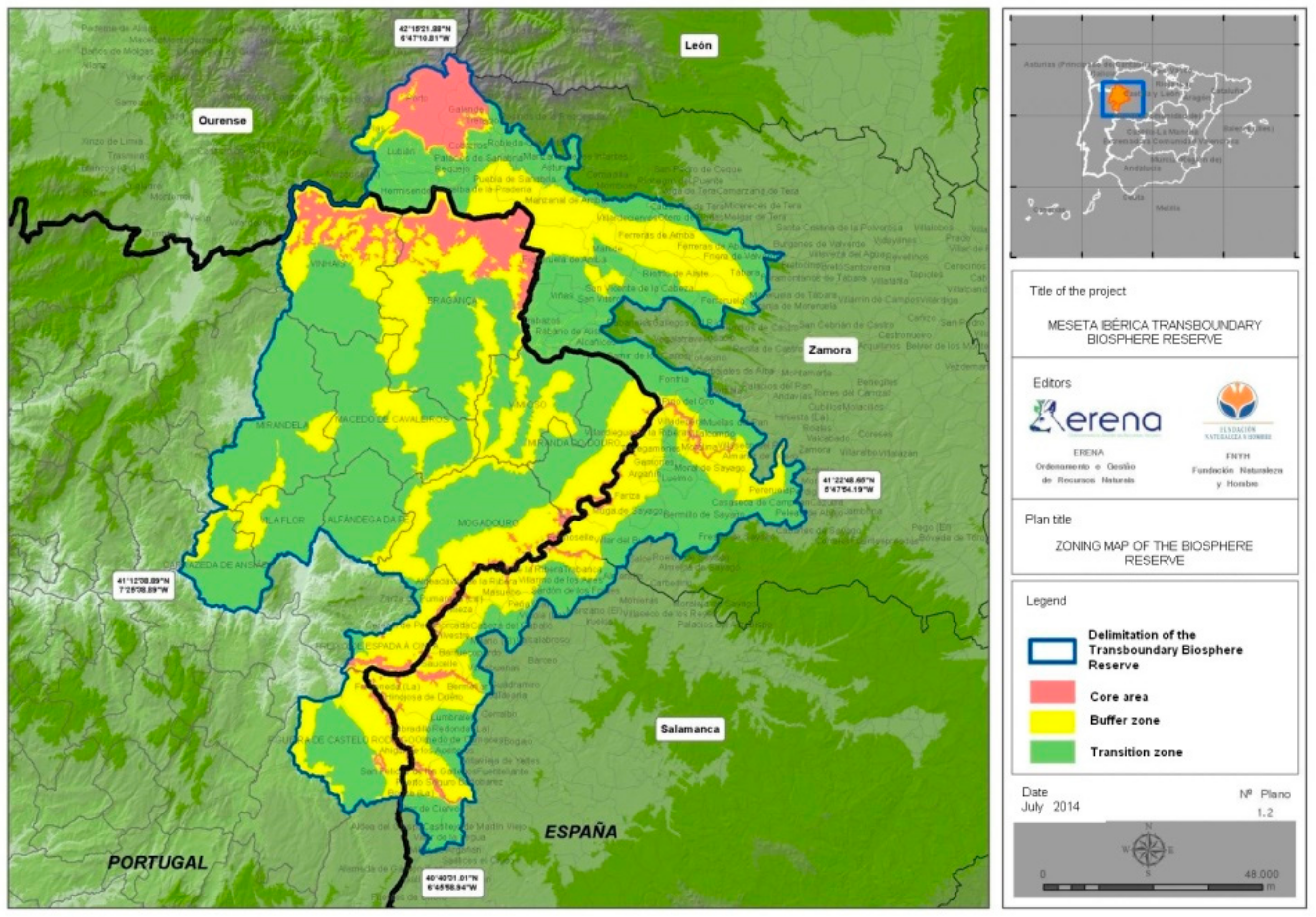
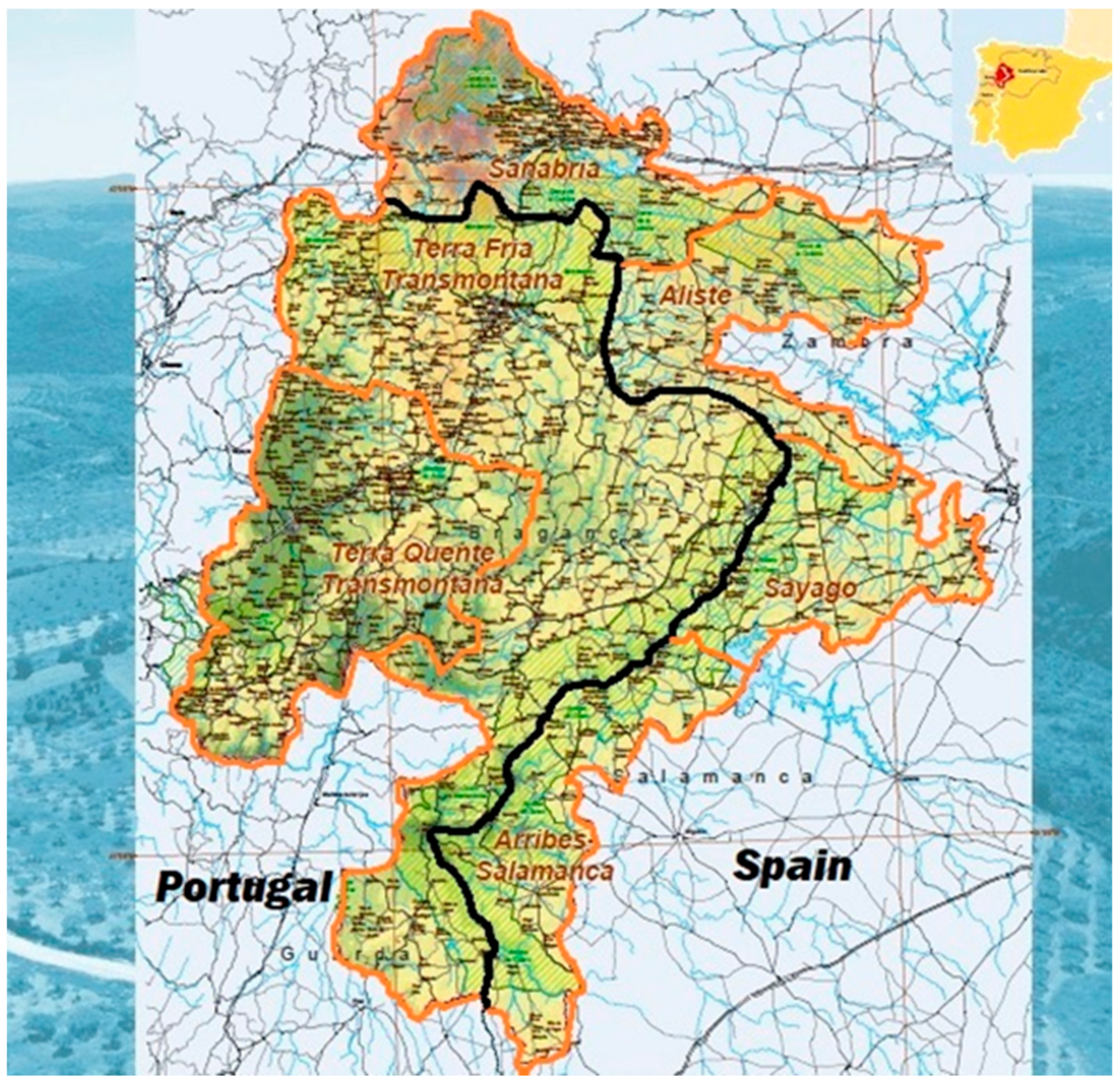
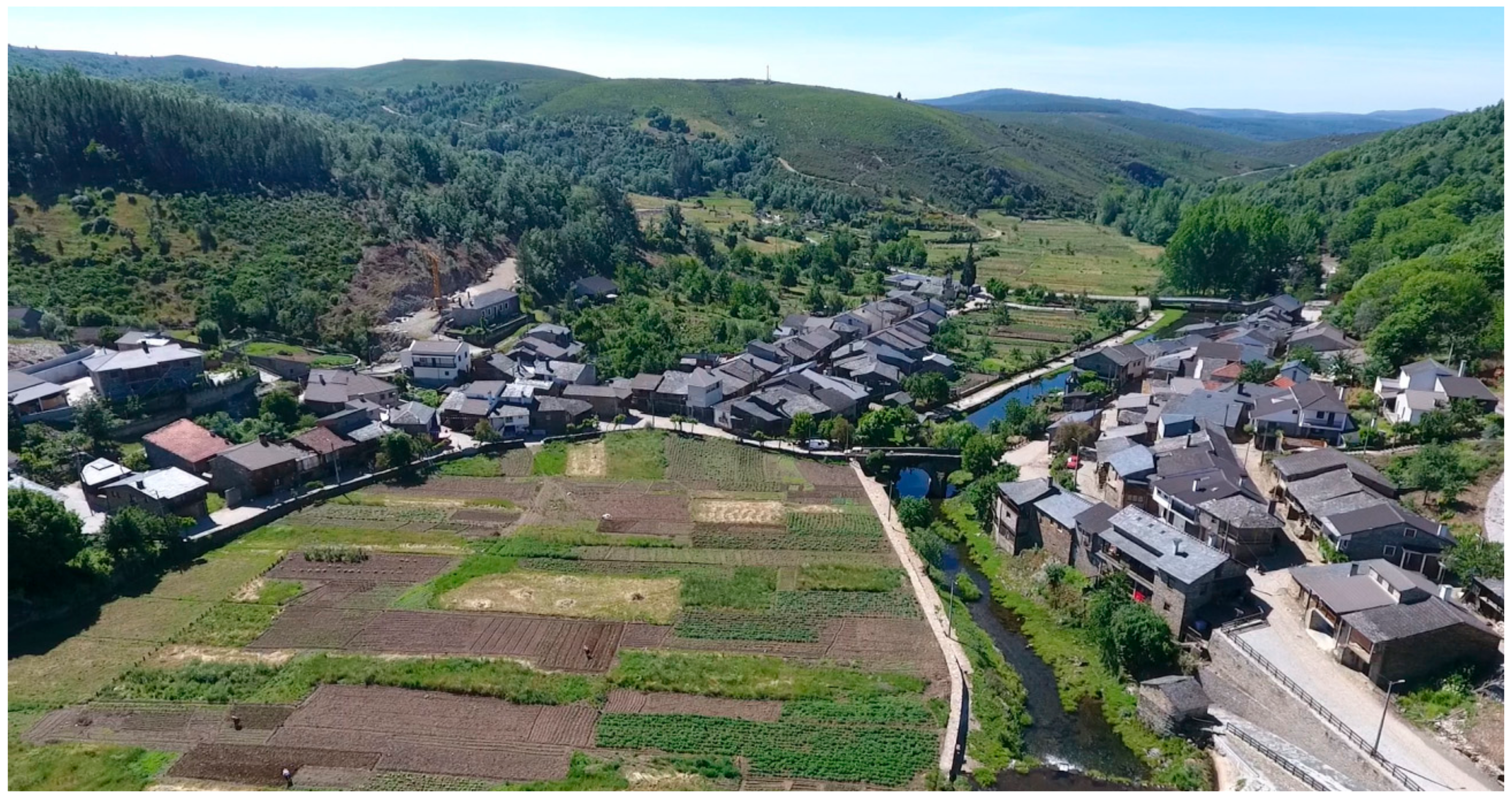
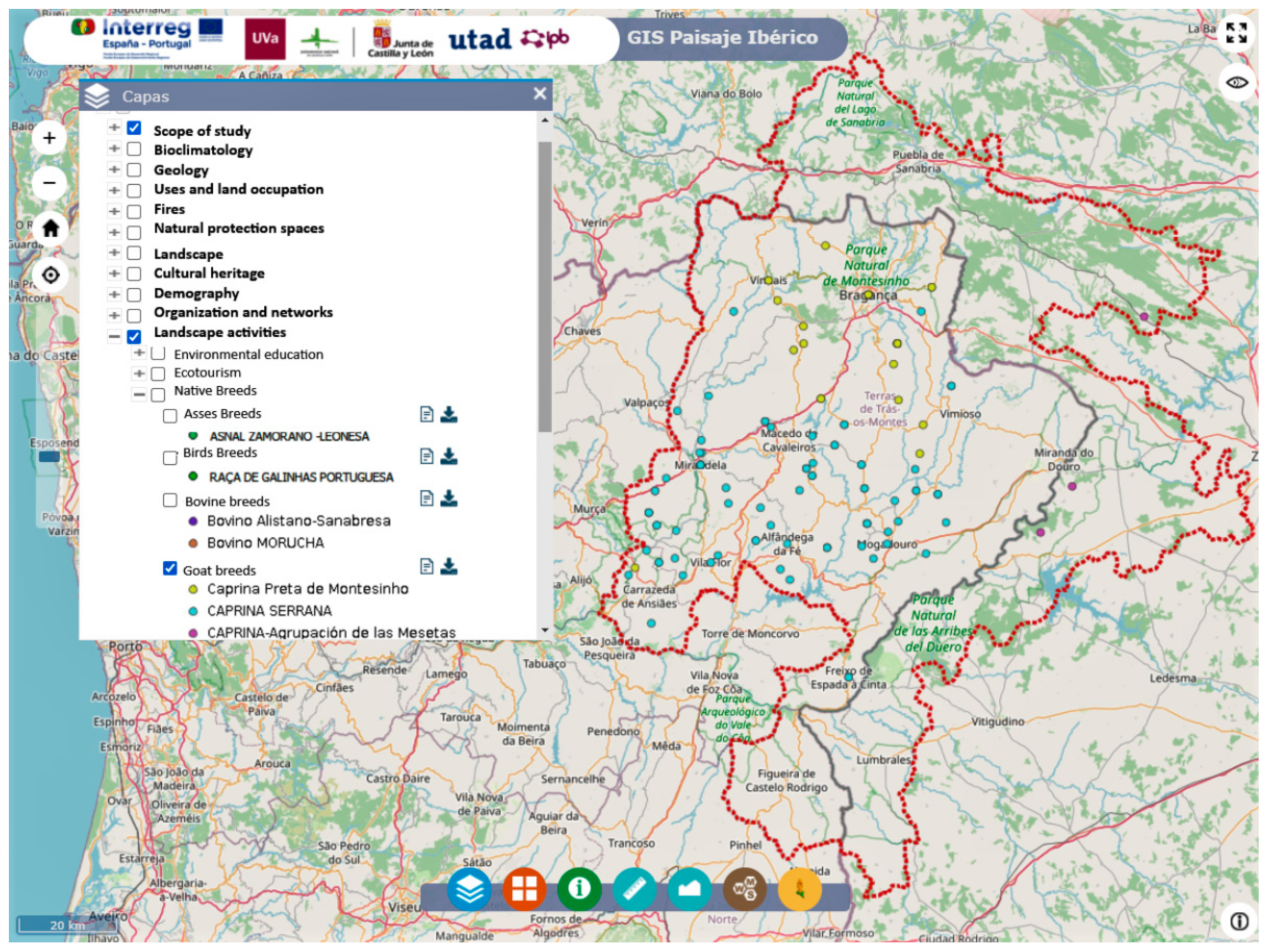
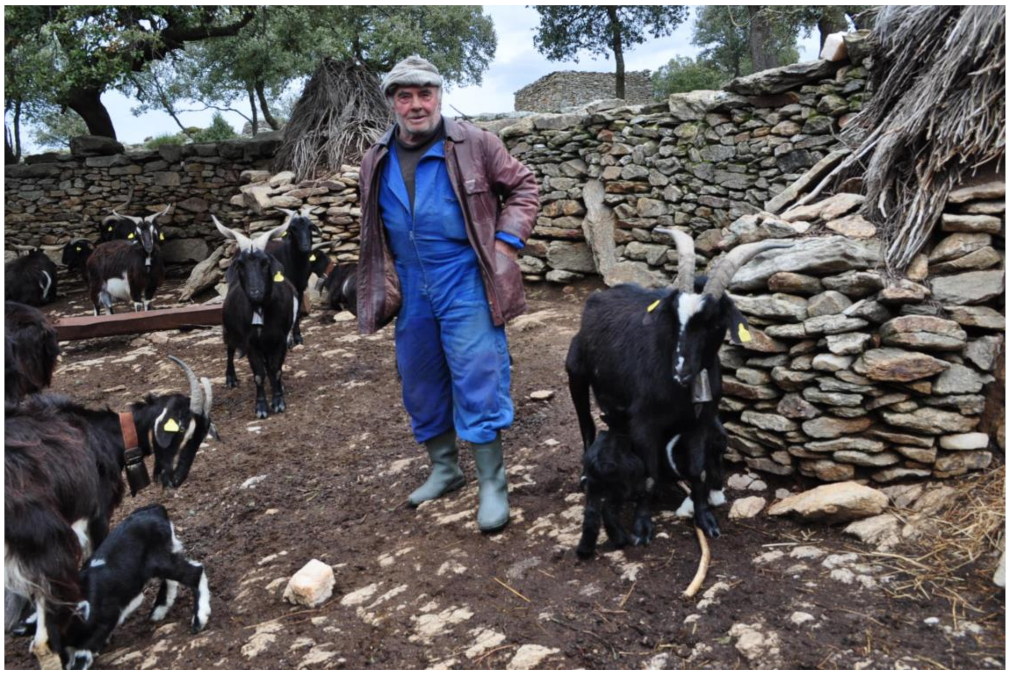
Table 1.
List of documented breeds of the MITBR in Portugal (P) and Spain (S).
| Predominant | Non-Predominant |
|---|---|
| Miranda donkey breed (P) | Amarela chicken breed (P) |
| Zamorano-Leonés donkey breed (S) | Branca chicken breed (P) |
| Alistana Sanabresa cattle breed (S) | Castellana Negra chicken breed (S) |
| Mirandesa cattle breed (P) | Pedrês Portuguesa chicken breed (P) |
| Sayaguesa cattle breed (S) | Preta Lusitânica chicken breed (P) |
| Cão de Gado Transmontano dog breed (P) | Morucha cattle breed (S) |
| Agrupación de las Mesetas goat breed (S) | Spanish Mastiff dog breed (S) |
| Preta de Montesinho goat breed (P) | Estrela Mountain Dog dog breed (P) |
| Serrana (Transmontano ecotype) goat breed (P) | Castellana sheep breed (S) |
| Churra da Terra Quente sheep breed (P) | Churra sheep breed (S) |
| Churra Galega Bragançana sheep breed (P) | Churra Badana sheep breed (P) |
| Churra Galega Mirandesa sheep breed (P) | Carea Leonés dog breed (S) |
| Bísaro pig breed (P) |
© 2020 by the authors. Licensee MDPI, Basel, Switzerland. This article is an open access article distributed under the terms and conditions of the Creative Commons Attribution (CC BY) license (http://creativecommons.org/licenses/by/4.0/).
Share and Cite
MDPI and ACS Style
Romano, J.; Pérez-Chinarro, E.; Coral, B.V. Network of Landscapes in the Sustainable Management of Transboundary Biosphere Reserves. Land 2020, 9, 320. https://doi.org/10.3390/land9090320
AMA Style
Romano J, Pérez-Chinarro E, Coral BV. Network of Landscapes in the Sustainable Management of Transboundary Biosphere Reserves. Land. 2020; 9(9):320. https://doi.org/10.3390/land9090320
Chicago/Turabian StyleRomano, Joaquin, Emilio Pérez-Chinarro, and Byron V. Coral. 2020. "Network of Landscapes in the Sustainable Management of Transboundary Biosphere Reserves" Land 9, no. 9: 320. https://doi.org/10.3390/land9090320
Note that from the first issue of 2016, this journal uses article numbers instead of page numbers. See further details here.