Transformation of Industrial Land in Urban Renewal in Shenzhen, China


1
Department of Construction Management and Real Estate, Shenzhen University, Shenzhen 518052, China
2
China Centre for Land Policy Research, Nanjing Agricultural University, Nanjing 210095, China
*
Author to whom correspondence should be addressed.
Land 2020, 9(10), 371; https://doi.org/10.3390/land9100371
Submission received: 27 August 2020
/
Revised: 24 September 2020
/
Accepted: 1 October 2020
/
Published: 4 October 2020
Abstract
:The redevelopment and transformation of industrial land has become an important part of urban renewal in China. This study adopts a spatial perspective to investigate the transformation of industrial land in Shenzhen based on a set of reliable data of all urban redevelopment projects of industrial land from 2010 to 2018. Research shows that the development of the real estate market, local government’s strategic demand for upgrading industrial structure, and the policy objective of improving land use intensity are important factors that affect the industrial land transformation. Industrial land has decreased significantly in urban renewal. About 881.79 ha (76.82%) of industrial land has been transformed into commercial, residential, and new industrial spaces. The planned industrial space is mainly located in the central and western regions, while the new commercial and residential spaces are mainly located outside the Special Economic Zone (SEZ). Redevelopment of industrial land has also transferred a certain scale of land to local governments for providing public facilities with an uneven spatial distribution between SEZ and non-SEZ. Therefore, industrial land transformation has brought significant effects on the urban spatial structure of this city. The study concludes with an evaluation of current industrial land redevelopment activities and provides suggestions for sustainable land development in the future.
1. Introduction
Urban renewal is an important activity of land reuse and space restructuring in urban development. Its main purpose is to solve a series of urban problems such as urban function decline, unreasonable spatial structure, and ecological environment deterioration through optimization and integration [1]. The land available for new construction in Chinese megacities has nearly been exhausted with the rapid urbanization and the continuous urban land expansion. Thus, urban renewal has become the main means of urban development in Chinese megacities [2]. Industrial land redevelopment has become an important part of urban renewal in recent years due to the increasingly urban problems such as a low level of land use efficiency and outdated urban functional structures [3].
The renewal of industrial land is usually included in the concept of brownfield regeneration in the Western context [4]. Brownfields have been defined differently to serve different research purposes depending on the concerns of national governments, institutions, or interest groups. In England, brownfields generally refer to:
“Previously developed land that is unused or may be available for development. It includes both vacant and derelict land and land currently in use with known potential for redevelopment. It excludes land that was previously developed where the remains have blended into the landscape over time”.[5]
Similar definitions also appear in Canada and other countries, where industrial land regeneration pays more attention to the redevelopment potential of the land. In America, brownfields usually refer to:
“Real property, the expansion, redevelopment, or reuse of which may be complicated by the presence or potential presence of a hazardous substance, pollutant, or contaminant”.[6]
Brownfield redevelopment can bring significant economic and environmental benefits, which may include revitalization of deteriorated communities, provision of new jobs and taxes, reduction of risk to public health, provision of green space, etc. [7,8]. Studies by Persky and Wiewel (1996) and De Sousa (2002) found that the public benefits provided by the brownfield redevelopment far outweigh those of greenfield development [9,10]. De Sousa (2003) examined 10 “brownfield greening” case studies in Toronto and found that brownfield redevelopment provides valuable opportunities for increasing green spaces in urban areas, thus bringing about benefits such as soil quality improvement, habitat creation, economic revitalization of communities, and so on [11]. According to De Sousa (2009), undeveloped brownfields have a negative impact on the value of adjacent real estate, while redevelopment of brownfield can significantly improve the surrounding real estate value [12].
From the perspective of capital, the main driving force for land redevelopment is to obtain sufficient “land rent gap” [13]. When the potential rent of a land is larger than the rent of its existing use function, more profit space will be brought to capital by the development and redevelopment of the land. When the land rent gap can attract investment and fill the cost and risk of development, urban renewal will occur. From the perspective of demand, changes of consumption, culture, and demand of the middle–class group are important forces to promote the renewal of urban space [14,15]. Although driven by supply and demand factors, several studies also emphasized the role of the state and policy guidance in land redevelopment [16]. The central and local government’s policy objectives are to solve the problem of inner city decline [17], reshape the local image, and ultimately improve the competitiveness of the city by promoting urban renewal and gentrification [18]. Empirically, existing literature on industrial land redevelopment has focused on its drivers and barriers [19,20,21,22], governance structures for redevelopment [23,24,25,26], and the evaluation of redevelopment outcomes [7,12]. For example, Lange and McNeil reported that brownfield regeneration in the United States usually occurs near airports, near central cities, or near railroads [27]. Longo and Campbell found that industrial land located in more prosperous areas (London, southwest and southeast) is more likely to be redeveloped [28].
In the process of urbanization in China, a series of market-oriented reforms has fundamentally changed the driving force of urban redevelopment. The role of local governments has been changed in decision making in urban redevelopment process. The reform of land system and housing system promoted the development of real estate market. As a result, urban renewal that used to be funded and led by the government has gradually become market oriented [29]. At present, urban renewal in China is mainly in the form of real estate development. Numerous residential redevelopment projects and industrial land redevelopment projects are no longer invested by local governments, but by private real estate developers. The development of the real estate market, transformation of industrial structure, government’s policy guidance, and demand for consumption and housing are the main driving forces for the redevelopment of urban space in China. In the past urbanization, cities in China have experienced rapid, expansive land expansion. The contradiction between urban land expansion and shortage of land resources requires a new mode of urban development. Redevelopment has been adopted by Chinese cities as new land development strategies to improve the quality and efficiency of existing land [30]. Wu analyzed the effect of urban renewal on industrial land transformation from the perspective of production consumption transformation and believed that “land commercialization” stimulates mass consumption, turns industrial land into consumable and tradable commodities, and drives the transformation of industrial land into residential and commercial land in urban central areas [31]. Several researchers investigated the role of different participants in industrial land transformation [32,33]. Existing literature has provided different perspectives and explanations on the mechanisms of industrial land transformation. However, the quantity of industrial land transformation and its main directions remain vague due to the lack of solid data sources. Understanding of spatial patterns of industrial land transformation at the city-level is limited.
A spatial perspective is adopted to address these gaps and investigate the transformation of industrial land in a Chinese megacity, which is important for evaluating the spatial effects of urban renewal yet has been rarely studied in the existing literature. At the theoretical level, the urban bid rent model proposed by Alonso (1964) is a classical theory to explain the relationship between land uses and location. Urban land was originally developed in accordance with its “market value”, with land rents varying according to different locations. Spatially differentiated land uses (residential, commercial, and industrial) are determined by accessibility to the city center. Each land use type has its own rent gradient or bid rent curve. With the gradual decline of land rent and land price from the city center to the suburbs, the land uses from the city center to the countryside are business districts, industrial areas, residential areas, and agricultural areas. The simple linear gradients concept has developed to include the polycentric urban structure of modern cities in later studies [34,35]. With the continuous urban land expansion in the urbanization process, a land rent gap is created due to the enlarged disparity between the potential land rent and current land rent [36]. Competition for land rent gap has led to urban renewal and land redevelopment processes. Based on the theoretical works, when a land rent gap emerges, industrial land located in the city center will be more likely to be transformed into some other land uses with higher land values (such as commercial uses) than that located in the suburban districts will be. However, spatial outcomes of industrial land transformation in Shenzhen seem to contradict such conclusions. On the one hand, a number of industrial sites located in the city center (SEZ area) continue to be used for industrial use after redevelopment. On the other hand, a large range of industrial sites located in the suburban districts (non-SEZ area) has been redeveloped into commercial and residential uses. Therefore, it is of significance to provide a city-level spatial analysis on industrial land transformation based on solid data sources, which will contribute to both the empirical and theoretical discussions on current land redevelopment and urban renewal practices.
Taking Shenzhen as the research area, this study analyzes the transformation directions and spatial pattern of industrial land based on urban renewal unit planning of all industrial land redevelopment projects in Shenzhen during 2010 to 2018. Compared with other big cities in China, Shenzhen has very limited land resources. After three decades of rapid urban land expansion in the urbanization process, most of its land available for construction has been exhausted. To sustain ongoing urbanization, Shenzhen has carried out a series of policies and regulations to promote land redevelopment and urban renewal. In this sense, Shenzhen is a pioneer city in China in the promulgation of urban renewal legislation. Shenzhen’s urban renewal experiences have also brought deep effects on urban renewal policies and practices in many other Chinese cities. Therefore, the study of Shenzhen can also lead to a broader understanding of current urban renewal in China. The remainder of this study is structured as follows. Section 2 introduces the study area and identifies the socio–economic context for industrial land transformation in the study area. Section 3 describes the research methods and data sources. Section 4 presents the empirical results. Section 5 concludes this study with land policy implications and suggestions for future studies.
2. Context for Industrial Land Transformation in Shenzhen
Shenzhen City is located in the southern part of China (Figure 1). Compared with other mega first-tier cities in China, the administrative area of Shenzhen is only 1991.71 km² (Land Survey of Shenzhen in 2009), among which the constructible land area is only 1004 km² [37], which is about 1/8 of the land area of Beijing, 1/4 of that of Guangzhou, and 1/3 of the area of Shanghai. The administrative area of Shenzhen is relatively small, and land resources are scarce. Shenzhen developed more than 750 km² of construction land by 2009 with the rapid urbanization and urban land expansion in the early stage. Most of its land available for construction has been developed. In this context, urban renewal has become an important strategy for urban development.
According to different socio-economic contexts and institutional arrangements, Shenzhen’s urban renewal practices can be divided into three stages: (1) prior to 2004; (2) from 2004 to the end of 2009; (3) from 2010 to present. At the first stage, the demand for redevelopment is insignificant. There are few corresponding policies and regulations for urban renewal. At the second stage, the city government has issued a series of urban renewal policies. These policies mainly focused on redevelopment of urban villages. During this period, institutional arrangements governing urban village renewal are largely state-led. According to the policies, the city government has the right to expropriate urban village land, and transfer the land use right to real estate developers. Such a process has created a high level of transaction costs in redevelopment and has led to a low level of redevelopment activities. Although 184 redevelopment projects were planned in Shenzhen, but only 10 of these projects were realized or included in the implementation process [38]. Since 2010, urban renewal in Shenzhen has entered a new stage. New policies and regulations were issued at the end of 2009 and implemented at the beginning of 2010. All the deteriorating urban sites such as old industrial areas, old urban areas, old residential areas, are included in the potential redevelopment areas. The urban renewal unit has become the basic spatial unit for initiating, implementing, and managing urban renewal activities. According to urban renewal policies, the relationship between developers, land and property owners and the government has been redefined. The developers and land and property owners all have the legal rights to initiate and implement land redevelopment [39]. Such a market-driven process has effectively promoted land redevelopment and has brought profound effects on industrial land transformation.
Under the new urban renewal unit system, landowners and developers can initiate an urban renewal project if they can agree and meet the application requirements of urban renewal policies. They can apply to the government for clarification of the land property rights. Thus, the urban renewal unit system is largely market oriented, encouraging the market actors to initiate and implement urban renewal projects. The institutional arrangement has established a basic framework for the marketization of Shenzhen’s urban renewal, and market actors such as land and property owners, and real estate developers are playing an increasingly important role in urban renewal activities [40]. As an important part of urban renewal in Shenzhen, the redevelopment of industrial areas is also based on this framework.
At least three main socio–economic processes have directly shaped the redevelopment and transformation of industrial land in Shenzhen. First, the development of the real estate market is an important factor driving the urban renewal and the transformation of the industrial land in Shenzhen. Shenzhen has a continuous net inflow of population with the continuous gathering of population, capital, technology, and other factors to large cities. In 2015, 2016, and 2017, the number of new permanent residents in Shenzhen reached 600,000, 530,000, and 550,000, respectively. The early form of providing low-cost housing through informal space, such as “villages in the city” and “small property rights housing,” has been unable to meet the growing demand for housing with the continuous growth of population and the increasing demand for high-quality formal living space. In addition, the market demand for urban commercial space and service space is increasing. The property market is booming, and property prices continue to soar. In the context of limited land resources and strong real estate market demand, urban renewal has become the main way of real estate supply. Numerous real estate developers have entered the urban renewal market in Shenzhen. Industrial sites are characterized by a low development intensity, and the relatively simple property rights status has attracted real estate investors. Compared with urban villages and other residential and commercial land, the redevelopment of industrial land involves a relatively lower cost of property compensation for demolition. Thus, industrial sites have become important targets for redevelopment under market-oriented urban renewal.
Second, upgrading industrial structure has become an important development strategy of local governments, which also have an influence on industrial land transformation in this city. At the national level, the 13th Five-Year National Strategic Industries Development Plan pointed out that “strategic emerging industries” should be promoted, such as “Internet +” and “smart robots” industries. At the city level, the 13th Five-Year Plan of Shenzhen’s Industrial Transformation also proposed four pillar industries and five key development directions. The Urban Planning Standards and Guidelines of Shenzhen City (hereinafter referred to as “UPSGS”), issued by the Shenzhen Municipal Government in 2014, proposed the concept of “new industrial land (M0)” for the first time to upgrade the traditional land use category, encourage industrial land upgrade, and promote industrial structure upgrade. According to UPSGS, M0 refers to new industrial land that integrates innovative industrial functions such as research and development, creativity, design, pilot scale test, pollution-free production, and related supporting service activities. Compared with traditional industrial land (M1), new industrial land has more diversified functions, including new-type industrial housing, complementary commercial space, infrastructure, and other property forms. The government has provided policy supports for transforming traditional industrial land into new industrial land. For example, industrial land redevelopment projects for M0 have rights to meet less requirements for planning permission, and have been allowed to obtain a higher development ratio.
In addition, improving land use efficiency and promoting intensive land use are important policy objectives for industrial land redevelopment in Shenzhen. According to the census data of the industrial sites of Shenzhen in 2009, industrial sites cover an area of 291 km², accounting for 39% of the total construction land area of the entire city. Average development intensity of industrial land is 0.91, building density is 29.56%, and average industrial output value is 4.418 billion yuan/km². From a spatial perspective, the efficiency of industrial land use in Shenzhen has evident spatial imbalance. The scale of industrial land outside the Special Economic Zone (non-SEZ) is relatively high, but the average industrial output value is much lower than that in the Special Economic Zone (SEZ). Compared with domestic megacities, such as Beijing and Shanghai, Shenzhen performs well in terms of industrial land use efficiency. However, compared with international metropolises such as New York, London, and Hong Kong, much room remains for Shenzhen to improve industrial land use efficiency. In this context, the Shenzhen municipal government issued a series of policies, such as the “Opinions of the Shenzhen Municipal Government on Further Strengthening Land Management and Promoting Economical and Intensive Land Use,” to encourage high-intensity development of industrial land, and additional investment and transformation, and improvement of plot ratio, to accelerate the transformation of industrial areas and promote land use efficiency. Under such a context, Shenzhen has been experiencing rapid, extensive industrial land transformation, which has profoundly changed the function structure and spatial pattern of Shenzhen’s industrial land.
3. Research Methods and Data Collection
3.1. Collection of Data on Industrial Land Redevelopment Projects
This study used geographic information system (GIS) techniques to investigate the transformation of industrial land and its spatial pattern based on a systematic collection of data on all urban renewal unit projects of industrial land in Shenzhen from 2010 to 2018. Under the institutional framework of urban renewal unit system in Shenzhen, the boundary and redevelopment direction of urban renewal units were proposed by developers and approved by government departments. Urban renewal unit planning generally involves many rounds of negotiation between developers and government departments. An urban redevelopment project should be implemented in strict accordance with the approved urban renewal unit planning. Therefore, based on the approved urban renewal unit planning of all industrial land redevelopment projects, the industrial land transformation and its spatial patterns can be investigated.
Data on urban renewal unit planning projects were collected from websites such as Municipal Bureau of Planning and Natural Resources of Shenzhen, and City Renewal and Land Development Bureau of districts [41,42,43,44,45,46,47,48,49,50,51], with detailed information on the name of the urban renewal unit, location of the project, boundary of demolition and reconstruction, land use before redevelopment, planed land use after redevelopment, and project area. Then, we obtained the geographic data of Shenzhen from Street Map (OSM), which includes geographic information on the boundary of administrative divisions, road network, subway lines, and stations. Data on ecological control line are obtained from the Shenzhen Planning and Natural Resources Bureau. The original data were mainly in JPG or CAD form without spatial attributes. We firstly use the geographic registration tool of ArcGIS to endow the data space attributes, and then use ArcScan tool to vectorize. Different data sources were then integrated into Shapefile, and exported as an Excel file. According to our data, 223 industrial land redevelopment projects were approved from 2010 to 2018 in Shenzhen, covering 960 industrial land parcels with a total land area of 1147.82 ha.
3.2. Classification of Land Uses after Redevelopment
Classification of redeveloped land use is very important for studying the transformation of industrial land in urban renewal. The types of industrial land reuses after redevelopment have been studied in much of the literature. In the case study of Howland (2003), industrial brownfields have been transformed into residential, commercial and industrial land [52]; De Sousa (2003) selected 10 cases to analyze the experience of transforming industrial land into green space (including parks, amusement parks, playgrounds, trails, greenways, etc.) [11]; Martinat (2018) investigated the perception of reuse options for specific brownfields and suggested that land reuse approaches may include residential, commercial, industrial, even parks and open spaces [53]; Osman (2015) conducted a study on the database of brownfields in the Czech Republic and found that the use of reclaimed brownfields was mainly for public facilities, services and retail, in combination with industrial activities [4]. Based on existing studies, the transformation direction of industrial land can be broadly divided into four categories according to their function in urban development: (i) land for residence, (ii) land for commerce, (iii) land for industry, and (v) land for public facilities [32]. In China, the Ministry of Land and Resources uses the “National Land Classification (Trial)” policy for land management, whereas the Ministry of Housing and Urban–Rural Development uses “Classification of Urban Land and Standards for Planning and Construction Land” regulations for the classification of urban land uses. According to the former policy, industrial land is included in industrial and mining storage land, whereas in the latter, industrial land and logistic storage land are listed separately. However, both classifications cannot cover the newly created “land for new industry” in Shenzhen. UPSGS uses a two-level system to classify different urban land uses. In the first level, there are 9 types of land uses including residential land (R), commercial service land (C), industrial land (M), logistics and storage land (W), public management and service facility land (GIC), transportation facility land (S), infrastructure facility land (U), green square land (G), and other land (E). These land uses are further divided into second-level land uses. Land uses in urban renewal unit planning are classified based on the second-level standard. In 2014, the government revised the UPSGS (2004). There are two major changes in the new version of UPSGS. Firstly, there is a new classification for industrial land use at the second-level, which is called new industrial land (M0). Secondly, several types of second-level land use in UPSGS (2014) have been merged and redefined. For example, commercial service land (C1), commercial office land (C2), service facility land (C3) and hotel land (C4) in UPSGS (2004) are merged to C1 in UPSGS (2014). The detailed differences between these two versions of UPSGS guidelines on land uses are presented in Table 1. The land use classification of urban renewal unit planning in Shenzhen is mainly based on UPSGS. Several of the industrial land redevelopment projects are based on an old version of UPSGS, whereas others are based on a new edition of UPSGS due to the long-time span of this study from 2010 to 2018 and the revision of UPSGS in 2014. Therefore, standards for land uses of industrial land redevelopment projects before and after 2014 are not always consistent. We classified the land uses after redevelopment into the following categories: (1) residential land (R); (2) commercial land (C); (3) commercial and residential mixed functional land (R+C); (4) new industrial land (M0); (5) traditional industrial land (M1); and (6) public facility land (P), which refers to the land contributed by the project to the local government for providing urban infrastructure or public service facilities, including public management and service facility land (GIC), green square land (G), transportation facility land (S), public facility land (U), and other land (E).
3.3. Explorative Spatial Data Analysis on Industrial Land Transformation
The research area of this study covered construction land of all administrative regions of Shenzhen, and the basic unit of the study was a 0.5 km × 0.5 km grid. Previous studies have used different sizes of grid as a research unit in different explorative spatial analyses. For example, Verburg (2004) studied the land use change pattern in the Netherlands using 0.5 km × 0.5 km grids; Li and Liu (2018) identified urban (sub) centers of 306 Chinese cities at the prefecture level based on explorative spatial analysis using 1 km × 1 km grid as the unit of observation. Grid sizes of 0.7 km × 0.7 km, 2 km × 2 km and some other sizes have also been found in the existing literature [54,55,56,57,58]. In this study, we chose 0.5 km × 0.5 km grid as the research unit to investigate the spatial pattern of industrial land transformation. A relatively satisfactory empirical result can be obtained based on such research units.
Exploratory Spatial Data Analysis (ESDA) techniques, including global and local spatial autocorrelation, were used to inspect the spatial pattern of industrial land redevelopment and transformation in Shenzhen. ESDA is a “data-driven” analysis method [59], which describes spatial distribution and reveals spatial connections [60]. First, global autocorrelation was adopted to determine the existence of spatial agglomeration, and then local spatial autocorrelation was used to determine its nature and location.
Global Moran’s I is calculated as follows:
where is the sample size, that is, the number of spatial locations; and is the observation value of spatial locations and , respectively; is the average value; and, spatial weight represents the proximity relationship between spatial positions and . The value range of the global Moran’s I index is [−1, 1]. A positive index means positive spatial autocorrelation, whereas a negative index means negative spatial correlation. The closer the absolute value of the index is to 1, the closer the relationship is between regions, which suggests that aggregation exists; The closer the absolute value of the index is to 0, the more uncorrelated the relationship is between regions, and the spatial distribution will be random. An index equal to 0 means no spatial autocorrelation.
Although Moran’s I index can reflect spatial autocorrelation, it cannot determine the type and location of agglomeration, that is, it cannot reflect agglomeration in a local space. Therefore, when global Moran’s I statistics show a spatial autocorrelation with statistical significance, local indicators of spatial association (LISA) will be used to determine the location and boundary of spatial aggregation.
Local Moran’s I is calculated as follows:
LISA are generally used to identify spatial outliers and local clusters. A positive means that the high (or low) value of area is surrounded by high (or low) values, that is, H-H or L-L clusters, which refer to local clusters. A negative means that the high (or low) value of area is surrounded by low (or high) values, that is, H-L or L-H clusters, which refer to spatial outliers. In addition, H-H clusters are called “hot spots”, which means that certain behaviors frequently occur in these cluster areas. L-L clusters are called “cold spots” to refer to activities that are below average in these cluster regions.
4. Empirical Results
4.1. Transformation of Industrial Land Use
Urban renewal in Shenzhen has led to a significant decrease in industrial land area. About 867.55 ha of industrial land has been mainly transformed into residential land, commercial and residential mixed-use land, commercial land, public facility land, and new industrial land (Table 2). A small portion of industrial land with an area of 280.27 ha has been redeveloped into both traditional and new industrial land, but with a much higher development density. Commercial and residential uses are the main directions for the transformation of industrial land. In the early stage of urbanization, numerous residential needs are mainly met by informal space, such as urban villages and small-property-rights housing. The demand for urban consumption space and service-oriented space is also increasing with the continuous growth of urban population and the increasing demand for high-quality formal residential space. The strong demand for high-quality formal residential space and commercial space have stimulated a prosperous real estate market. Investment in real estate development has brought developers large returns with the constantly increasing property price. In this context, industrial land which is allowed to be transformed into residential or commercial use in urban planning has become very attractive to real estate developers. Therefore, the large amount of industrial land transformation into residential or commercial use can be understood as the result of profitable property-led development.
A large area of traditional industrial land has been redeveloped into new industrial space to fulfil the local development strategy of upgrading urban industrial structure. A closer examination finds that most of the urban renewal unit planning involving industrial land transformation into new industrial land was approved before 2018 and has declined since then. Before 2018, policies and regulations for new industrial land use were still in the early stage, which cannot fully predict and effectively regulate market behaviors of new industrial land development and use. Under such circumstances, several of the redevelopment projects named new industrial land were property-led commercial development. For example, our field visits found that numerous research and development (R-D) buildings built on new industrial land have already been used as commercial or office space, which can bring much higher profits to developers. According to the “13th Five-Year Plan on Urban Renewal of Shenzhen City,” two requirements must be met for redeveloping industrial land into new industrial land. First, industrial land should be located in the industrial zone within 500 m of subway stations. Second, industrial land in the non-SEZ should be located outside the industrial parks or industrial area line but located in the planned industrial areas of the 13th Five-Year Plan. However, our empirical analysis shows that more than half of the redevelopment projects for new industrial land do not conform to the industrial renewal policy. As a response, the Shenzhen municipal government carried out a series of new policies to guide and manage redevelopment for new industrial land better. According to two new renewal policies (“The Measures of Shenzhen Municipality on The Management of Industrial Block Lines” and “Notice on Further Strengthening the Architectural Design Management of R-D Buildings”) issued in 2007, each district was distributed with strict quotas for redevelopment projects on new industrial land. Furthermore, standards for the architectural design of the R-D buildings were clarified to prevent buildings on new industrial land from being transformed into commercial or residential functions in actual use.
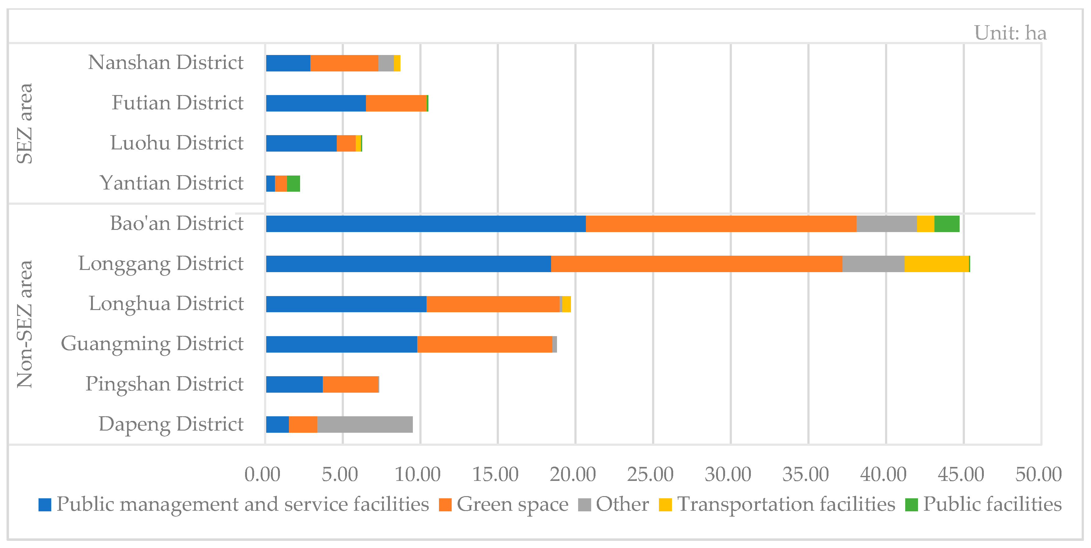
A large portion of redeveloped land has been transferred to local governments as public land for the provision of public facilities, such as public hospitals and primary schools. Under the current urban renewal institutional arrangements in Shenzhen, urban redevelopment projects are implemented by developers, but they are required to contribute a certain proportion of land to the government for supporting public facilities. According to our empirical data and analysis, this policy has been well implemented in most of the redevelopment projects. The policy required that “more than 3000 m2 and no less than 15% of the project land should be transferred to the government for free to implement urban infrastructure, public service facilities, and urban public interest projects.” Several developers even transferred much more land than the basic requirements to obtain project approval as soon as possible. As a result, the actual average contribution rate of public land is far more than 15%. In the case of industrial land redevelopment for commercial and residential use, the proportion of transferred public land has exceeded 30%. The redevelopment of the industrial land has contributed a large amount of public facility space for urban development. Of the 223 redevelopment projects, 167 projects have transferred land to local governments for public facilities with a scale of 173.16 ha (Table 3). Two major land uses of transferred public land are public management and service facility land (GIC), and green space (G). Land for public service facilities is mainly used for education facilities, including primary schools and junior middle schools.
4.2. Spatial Pattern of Industrial Land Transformation
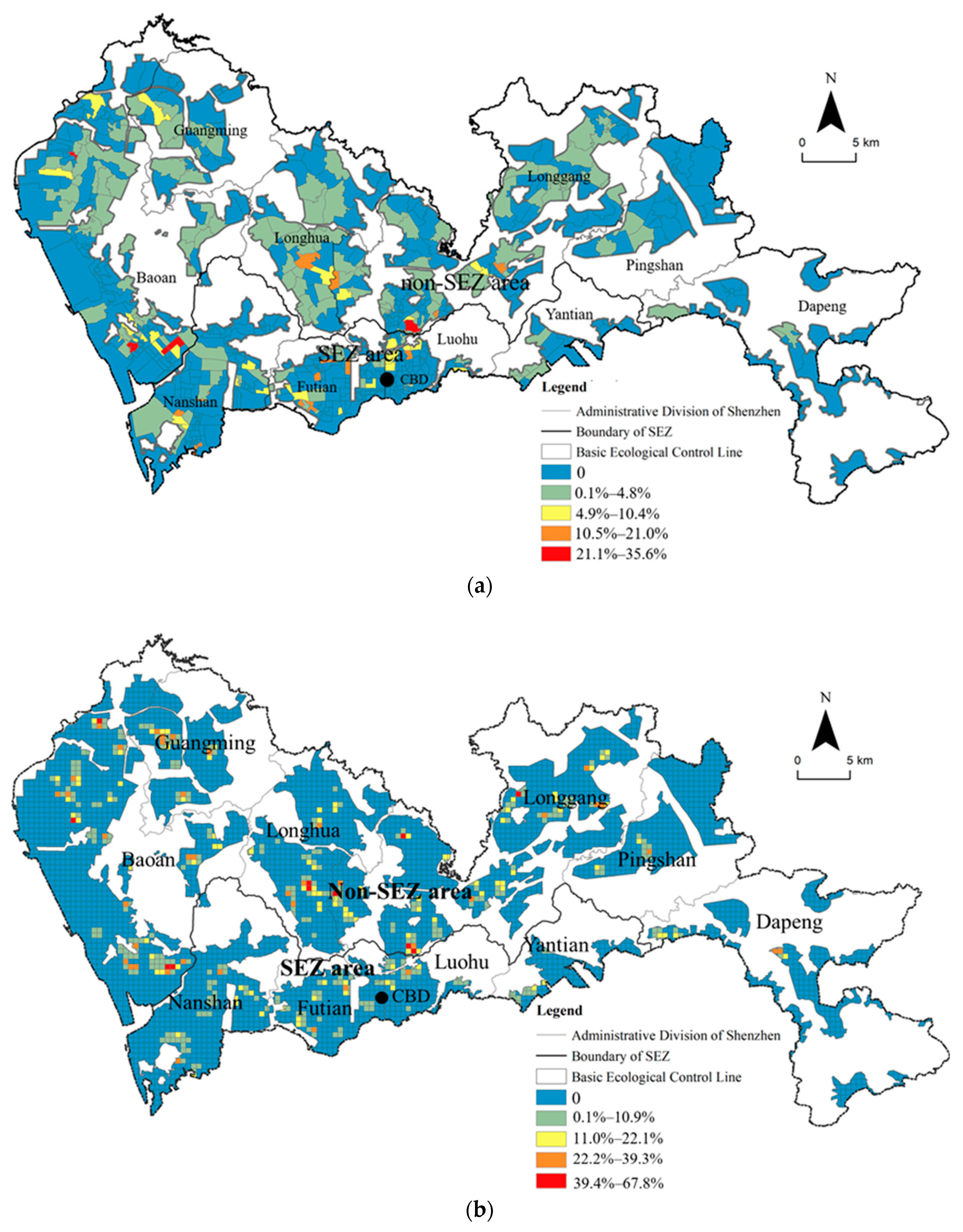
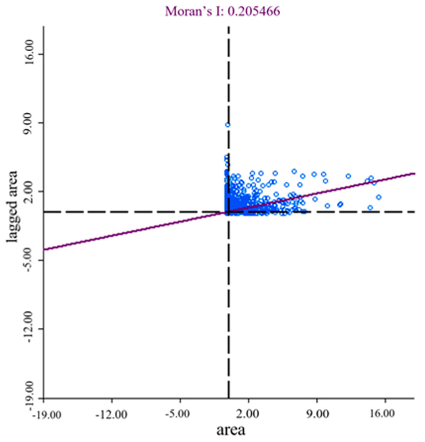
Global spatial autocorrelation was used in the first step to investigate the spatial pattern of industrial land transformation in Shenzhen. Figure 2a shows the percentage of industrial land redevelopment projects in different communities. The natural break point method (one of the most commonly used methods for data classification—classes are based on the natural grouping inherent in the data, class breaks are created in a way that best groups similar values together and maximizes the differences between classes) divided the value into five parts; the value range is 0%–35.6%: 0% means no redeveloped industrial land in the community, 0.1%–4.8% means a low density of industrial redevelopment, 4.0%–10.4% means a medium density, 10.5%–21% means a higher density, and 21.1%–35.6% means the highest density. The results show that the redevelopment of industrial land is mainly distributed in the central and western regions of Shenzhen City but less in the eastern region. The highest density of industrial redevelopment activities was observed in Dalang, Baomin, Mabu, and Xinyang communities of Baoan District and Luogang Community of Longgang District. A high density of redevelopment projects was observed in the southwest of Nanshan District (including Yuegui, Nanshan, Yuyi and Yuer communities), the southwest and north of Futian District (including Xiasha, Jindi, Shiling, Meifeng, and Lianhua communities), the central and western parts of Longgang District (including Dafapu, Nanxin, Songbai, and Huaqiaoxincun communities), Cuijin community in the central region of Luohu District, and Jinglong community in the central region of Longhua District. In addition, this study took 0.5 km × 0.5 km as the unit, dividing the Shenzhen City area into 5248 grids (except the scope of ecological-control line), and mapped the data of industrial redevelopment projects into grids, among which 185 grids were involved in industrial redevelopment projects. Figure 2b shows the percentage of the redeveloped industrial land in each grid. The value ranges from 0% to 67.8%. Calculating the redevelopment rate with a more accurate spatial resolution showed that the spatial pattern of industrial land redevelopment at the grid level is approximately consistent with that at the community level. However, differences were noted between these two results. For example, at the community level, no communities have a high density of redevelopment projects in the eastern part of Shenzhen City, such as the eastern part of Longgang District, Dapeng District, and Pingshan District. However, grid-level analysis showed several units with a high density of redevelopment activities. This difference may be due to different community sizes. Moran’s I statistic was calculated to test whether the grid with a high redevelopment rate is closer to other similar grids in space. The results show that Moran’s I is 0.241976 (p < 0.001), which indicates that the industrial land redevelopment activities in Shenzhen have spatial aggregation and positive spatial correlation.
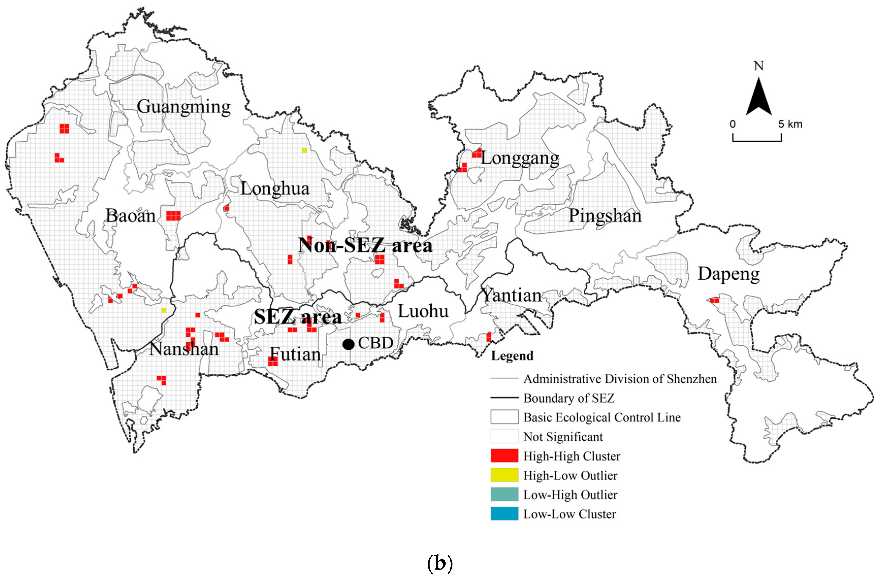
LISA cluster maps and scatter diagram of industrial redevelopment activities were conducted at the grid level to examine the local agglomeration of industrial redevelopment and the spatial location of industrial land transformation in Shenzhen further. Figure 3 shows the spatial agglomeration characteristics of industrial land redevelopment (p < 0.05). The results show 185 grids involved in significant statistical spatial clusters of industrial land transformation. The results also suggest that industrial land transformation is featured by a high-high agglomeration (H-H). Hot spots of industrial land redevelopment are mainly located in Baoan Central District, Guangming Central District, Longhua Central District, and Longgang Central District, Buji Subdistrict, Nanshan Subdistrict, and Shatou and Meilin Sub-districts of Futian District; Qingshuihe–Sungang Subdistrict of Luohu District. A few hot spots were also found in Pingshan District and Dapeng District in Eastern Shenzhen. These hot spots and their surrounding areas have high-intensity industrial redevelopment activities (Table 4, Figure 4).
We further analyzed and compared the local spatial autocorrelation of traditional industrial land redevelopment projects and new industrial land redevelopment projects (Figure 5). We found that traditional industrial land has been greatly reduced, but traditional industrial land redevelopment projects have shown certain spatial aggregation characteristics and are mainly located in the southwest of Shenzhen. Five clusters of traditional industrial land redevelopment projects in the non-SEZ areas include Shapu Industry Park, Fuyong Industry Park, Xixiang Subdistrict and Shiyan Subdistrict of Baoan District, and Henggang Subdistrict of Longgang District. The scale of agglomeration of traditional industrial land redevelopment projects in the SEZ area is smaller than that in the non-SEZ area. The two main clusters are located in Yanshan Community of Nanshan District and Qingshuihe–Sungang Subdistrict of Luohu District. According to the city industrial development plan, Yanshan Community is positioned as the place for developing secondary industry and is an important component of the “Shekou Net Valley” development strategy, which aims to promote the transformation and industrial development of the Shekou Area. The Qingshuihe–Sungang area is one of the seven major logistic parks in Shenzhen, which is planned for the use of logistics and storage. As far as the new industrial land redevelopment projects are concerned, the SEZ and non-SEZ areas have accommodated numerous projects. According to the city industrial development plan, the SEZ area including Nanshan, Futian, and Luohu Districts is positioned as the R-D headquarters, and creative design center. In the SEZ area, the projects show a stronger agglomeration than in the non-SEZ area. However, the distribution of new industry in the non-SEZ is relatively small and scattered, and “hot spots” are mainly located in Xixiang, Shajing, and Shiyan subdistricts of Baoan District, and Bantian and Nanwan subdistricts of Longgang District in the central and western parts of Shenzhen City. Only three new industrial projects are in the eastern part of Shenzhen: Huilongpu New Industrial Zone and Huanggekeng Industrial Zone in Longgang District, and the Second Industrial Zone (B) in Dapeng District. All of them are planned as R-D headquarters of high-end enterprises to upgrade the industrial structure of eastern Shenzhen. Overall, the spatial distribution of traditional industrial land redevelopment projects and new industrial land redevelopment projects is significantly higher in the central and western regions than that in the eastern regions in Shenzhen City. We can safely conclude that industrial land redevelopment and transformation has greatly changed the spatial structure of industrial development in this city, which will be mainly located in the central and western regions of Shenzhen in the future.
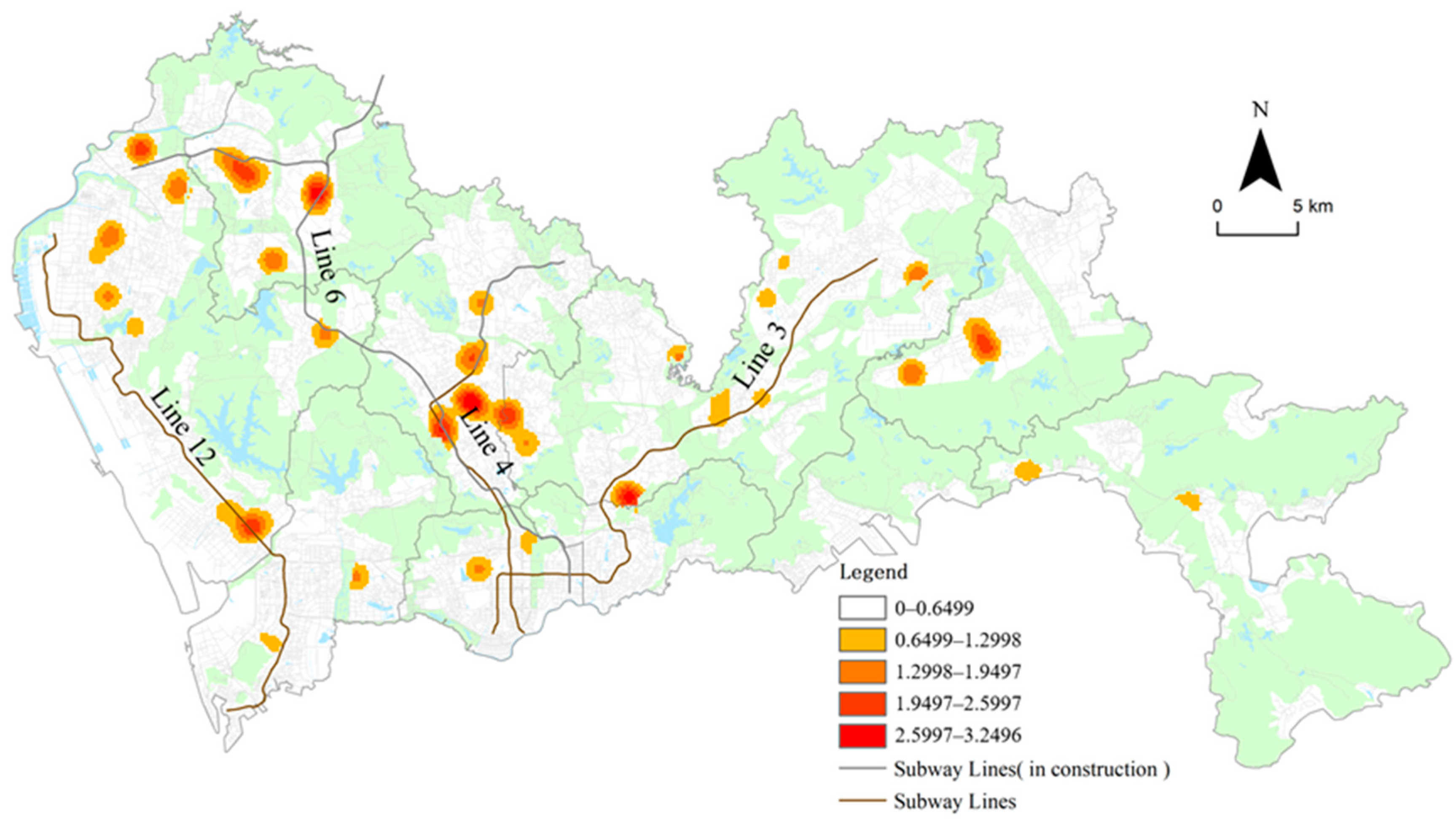
The transformation of the industrial land into commercial and residential space is mainly located in the non-SEZ area, which has brought significant changes in the spatial structure of commercial and residential space in the city (Figure 6). Most of the redevelopment projects of industrial land transformation into commercial space are concentrated in four districts, namely, Longgang, Baoan, Longhua, and Guangming District, of which Longgang District accounts for the largest proportion. The density of transformation is higher in the western and central regions than in the eastern regions of Shenzhen City. Four clusters were found in Baoan Central District, Longhua Central District, Guangming Central District and Shajing Central District. Accessibility of metro stations plays an important role in transforming industrial land into commercial space, which is beneficial for attracting enterprises, capital, and information. Commercial redevelopment projects are mainly distributed close to subway stations, which is consistent with the transit-oriented development plan of the city. The empirical results show that industrial land transformation into residential space in Shenzhen has a close relationship with the existing metro lines and those under construction. Figure 5 shows that most of the residential projects are located along Metro Line 3, Line 4 (North Extension, in construction), Line 6 (in construction), and Line 12 (in construction).
Industrial land transformation in Shenzhen has also transferred a large amount of public land to the local government for the provision of public facilities. Provision of public land is highly uneven from the spatial perspective. The majority of transferred public land is located in the non-SEZ area. The results show that increased public land through industrial land redevelopment has reached 145.45 ha, which is about five times more than that in the SEZ area. Figure 7 shows the distribution of transferred public land between different districts. Four districts of the non-SEZ area including Baoan, Longgang, Longhua, and Guangming districts have a large share of the transferred public land from the industrial land redevelopment projects of the entire city. For a very long time in the context of urbanization over the past decades, the SEZ and non-SEZ areas in Shenzhen have shown very different development processes and outcomes due to different socio–economic conditions and institutional arrangements on land ownership [31]. The development of the SEZ area is mainly based on state land according to urban planning, featured by modern built environments and a high level of infrastructure construction. However, the majority of the non-SEZ area is developed by dispersed villages based on collective land without state regulations and planning. As a result, the non-SEZ area is characterized a chaotic built environment and substandard infrastructure and public facilities. The large scale of industrial land transformation and transfer of public land has created opportunities for a more balanced development between the SEZ and non-SEZ areas, which helps redefine the urban spatial structure of the whole city.
5. Discussion and Conclusions
The institutional change of the urban renewal system toward marketization has greatly promoted industrial land redevelopment and transformation in Shenzhen. This study shows that the development of real estate market, the local government’s strategic demand for upgrading the industrial structure, and the policy objective for improving industrial land use intensity are important factors that influence the direction of industrial land transformation. Consistent with previous studies on industrial land transformation in other cities [61,62,63], industrial land has decreased significantly in Shenzhen’s urban renewal process at the city level, and most of the decreased industrial land has been transformed into commercial and residential uses. It is found that a portion of traditional industrial land has been redeveloped into new industrial spaces to support the development of new industries, such as high-technology industries and production service industries. The local government has played an important role in the transformation from traditional industrial land into new industrial land. For example, UPSGS has been revised to refine land use classification standards. Relevant policies and regulations have been made to promote the provision of new industrial space in redevelopment. Such experiences have also brought deep impacts on urban renewal policies and practices in many other Chinese cities such as Shanghai, Guangzhou, Dongguan, Zhengzhou etc. [64,65]. Our empirical study shows that redevelopment of industrial land in Shenzhen has also transferred a certain scale of land to local governments for providing public facilities such as public hospitals, primary schools and green spaces, which will greatly improve the built environment and public service in the future.
The spatial analysis shows that industrial land transformation into commercial and residential space is mainly located in the suburban areas (non-SEZ areas), while the planned new industrial space is mainly located in the central and western regions of the city. Such a spatial pattern is very different from what has been found in some other studies. According to location theories and existing empirical literatures, the closer the industrial land is to the city center, the more likely it is to be transformed to residential and commercial space. The suburbs and outer development zones will become the hot spots for industrial agglomeration [55,66]. The unique spatial pattern of industrial land transformation in Shenzhen has thus indicated the importance of local context in understanding land redevelopment and urban renewal in China. According to our study, public land contributed by industrial redevelopment projects has shown an uneven spatial distribution between the SEZ and non-SEZ areas. Most of the transferred public land is located in the non-SEZ area, where the level of public construction is far behind that in the SEZ area in the previous urbanization process. The local governments and the dynamic institutional arrangements have played important roles in the processes and spatial outcomes of industrial land transformation in Shenzhen. In sum, industrial land transformation has brought significant effects on the urban spatial structure of this city, which will lead to a more balanced urban development in the future.
The transformation of the industrial land in Shenzhen is largely shaped by the local context of urban development and economic transformation. In the early stage of urbanization, numerous migrants are accommodated by informal housing, such as urban villages and small-property-rights housing [67,68]. The market demand for urban consumption space and service space is also increasing with the continuous growth of urban population and the increasing demand for high-quality formal housing. However, numerous manufacturing enterprises in Shenzhen have been moving to inland cities in recent years. Thus, strong incentives exist to transform industrial land into residential and commercial space. Such processes have played important roles in relieving housing pressure, improving housing quality, and meeting the urban consumption and service needs. However, property-led industrial land redevelopment is profit-oriented and has inevitably led to the rapid loss of industrial space, which may have negative effects on the industrial development of the city. Although the local government has revised the planning standards to include a new type of industrial land use (M0) to promote the upgrading of industrial structures, the study found that more than half of the redevelopment projects for new industrial land do not conform to the industrial renewal policy. For example, a large number of new industrial land redevelopment projects are located within the scope of planned traditional industrial zones, which are not allowed for new industrial land use according to relevant policies. Some new industrial spaces were transformed into commercial and residential uses in the actual activities. Such results have imposed great challenges to future industrial development. As a response, Shenzhen municipal government has promulgated a series of new policies on guiding and managing the new industrial land redevelopment projects since 2017, which include detailed and strict requirements on architectural design, property rights transfer, types of industries, land recovery etc. How to balance the need of urban industrial land and the market demand of transformation of industrial land into commercial and residential space has become an important question which needs to be addressed carefully in the future.
To conclude, this study adopts a spatial perspective to investigate the transformation of industrial land in Shenzhen based on a set of reliable data of all urban redevelopment projects of industrial land from 2010 to 2018. Research shows that the development of the real estate market, local government’s strategic demand for upgrading industrial structures, and the policy objective of improving land use intensity are important factors that affect the industrial land transformation. On the one hand, industrial land transformation in Shenzhen has shown some similar trends with other studies. A large number of industrial sites have been redeveloped into commercial and residential uses. On the other hand, the spatial pattern of industrial land transformation in Shenzhen is very different from what has been found in the existing studies. This study can thus contribute to a better understanding of industrial land transformation in China. Spatial analysis based on solid data sources can be applied to other cities to investigate diverse industrial land redevelopment processes and spatial outcomes, which will contribute to both the empirical and theoretical discussions on current land redevelopment and urban renewal practices.
This study has its own limitations. Although it has been found that location and local policies are important factors affecting industrial transformation directions, we did not measure the specific impacts of each factor. In another working paper of the authors, the spatial determinants of industrial land transformation are identified and empirically tested based on logistic regression models, which will be submitted to another academic journal later.
Author Contributions
Conceptualization, Y.L. and K.C.; methodology, Y.L. and K.C.; software, F.L. and K.C.; validation, Y.L. and J.Z.; formal analysis, K.C.; investigation, Y.L.; resources, Y.L.; data curation, K.C.; writing—original draft preparation, K.C.; writing—review and editing, Y.L. and J.Z.; visualization, F.L.; supervision, J.Z.; project administration, Y.L.; funding acquisition, Y.L. All authors have read and agreed to the published version of the manuscript.
Funding
This research was funded by the National Natural Science Foundation of China (74804113).
Acknowledgments
We especially thank the National Natural Science Foundation of China for funding this study. We would also like to thank the three anonymous reviewers for their constructive comments. This paper also benefited from the discussion at the 15th Conference on Spatial Behavior and Planning: Spatiotemporal Behavioral Interaction and Urban Sustainability.
Conflicts of Interest
The authors declare no conflict of interest.
References
- Zheng, W.; Shen, G.; Wang, H. A review of recent studies on sustainable urban renewal. Habitat Int. 2014, 41, 272–279. [Google Scholar] [CrossRef] [Green Version]
- Adams, D.; Hastings, E. Urban renewal in Hong Kong: Transition from development corporation to renewal authority. Land Use Policy 2001, 18, 245–258. [Google Scholar] [CrossRef]
- Boyang, G.; Weidong, L.; Dunford, M. State land policy, land markets and geographies of manufacturing: The case of Beijing, China. Land Use Policy 2014, 36, 1–12. [Google Scholar] [CrossRef]
- Osman, R.; Frantál, B.; Klusáček, P.; Kunc, J.; Martinat, S. Factors affecting brownfield regeneration in post-socialist space: The case of the Czech Republic. Land Use Policy 2015, 48, 309–316. [Google Scholar] [CrossRef]
- ODPM. Sustainable Communities: Homes for All. Cm 6424; The Stationery Office: London, UK, 2005.
- Amekudzi, A.; Fomunung, I. Integrating Brownfields Redevelopment with Transportation Planning. J. Urban Plan. Dev. 2004, 130, 204–212. [Google Scholar] [CrossRef]
- Wedding, G.C.; Crawford-Brown, D. Measuring site-level success in brownfield redevelopments: A focus on sustainability and green building. J. Environ. Manag. 2007, 85, 483–495. [Google Scholar] [CrossRef]
- Navrátil, J.; Krejčí, T.; Martinat, S.; Pasqualetti, M.J.; Klusáček, P.; Frantál, B.; Tochackova, K. Brownfields do not “only live twice”: The possibilities for heritage preservation and the enlargement of leisure time activities in Brno, the Czech Republic. Cities 2018, 74, 52–63. [Google Scholar] [CrossRef] [Green Version]
- Persky, J.; Wiewel, W. Central City and Suburban Development: Who Pays and Who Benefits? Great Cities Institute: Chicago, IL, USA, 1996. [Google Scholar]
- De Sousa, C. Measuring the Public Costs and Benefits of Brownfield versus Greenfield Development in the Greater Toronto Area. Environ. Plan. B 2002, 29, 251–280. [Google Scholar] [CrossRef]
- De Sousa, C. Turning brownfields into green space in the City of Toronto. Landsc. Urban Plan. 2003, 62, 181–198. [Google Scholar] [CrossRef]
- De Sousa, C.A.; Wu, C.; Westphal, L.M. Assessing the Effect of Publicly Assisted Brownfield Redevelopment on Surrounding Property Values. Econ. Dev. Q. 2009, 23, 95–110. [Google Scholar] [CrossRef] [Green Version]
- Lai, Y.; Zhang, X. Redevelopment of industrial sites in the Chinese ‘villages in the city’: An empirical study of Shenzhen. J. Clean. Prod. 2016, 134, 70–77. [Google Scholar] [CrossRef]
- Jackson, E.; Butler, T. Revisiting ‘social tectonics’: The middle classes and social mix in gentrifying neighbourhoods. Urban Stud. 2014, 52, 2349–2365. [Google Scholar] [CrossRef]
- Moos, M. From gentrification to youthification? The increasing importance of young age in delineating high-density living. Urban Stud. 2016, 53, 2903–2920. [Google Scholar] [CrossRef]
- Eshuis, J.; Edwards, A. Branding the City: The Democratic Legitimacy of a New Mode of Governance. Urban Stud. 2012, 50, 1066–1082. [Google Scholar] [CrossRef] [Green Version]
- Bromley, R.D.; Tallon, A.R.; Roberts, A.J. New populations in the British city centre: Evidence of social change from the census and household surveys. Geoforum 2007, 38, 138–154. [Google Scholar] [CrossRef]
- Hall, P.; Falk, N. Good Cities, Better Lives: How Europe Discovered the Lost Art of Urbanism; Routledge: London, UK, 2013. [Google Scholar]
- Adams, D.; Disberry, A.; Hutchison, N.; Munjoma, T. Ownership Constraints to Brownfield Redevelopment. Environ. Plan. A 2001, 33, 453–477. [Google Scholar] [CrossRef]
- Green, T. Evaluating predictors for brownfield redevelopment. Land Use Policy 2018, 73, 299–319. [Google Scholar] [CrossRef]
- Loures, L. Post-industrial landscapes as drivers for urban redevelopment: Public versus expert perspectives towards the benefits and barriers of the reuse of post-industrial sites in urban areas. Habitat Int. 2015, 45, 72–81. [Google Scholar] [CrossRef]
- Ahmad, N.; Zhu, Y.-M.; Shafait, Z.; Sahibzada, U.F.; Waheed, A. Critical barriers to brownfield redevelopment in developing countries: The case of Pakistan. J. Clean. Prod. 2019, 212, 1193–1209. [Google Scholar] [CrossRef]
- Thomas, M.R. A Weighted, Multi-Attribute, Site Prioritization and Selection Process for Brownfield Redevelopment. Environ. Pr. 2002, 4, 95–106. [Google Scholar] [CrossRef]
- Chen, Y.; Hipel, K.W.; Kilgour, D.M.; Zhu, Y. A strategic classification support system for brownfield redevelopment. Environ. Model. Softw. 2009, 24, 647–654. [Google Scholar] [CrossRef]
- Alberini, A.; Longo, A.; Tonin, S.; Trombetta, F.; Turvani, M. The role of liability, regulation and economic incentives in brownfield remediation and redevelopment: Evidence from surveys of developers. Reg. Sci. Urban Econ. 2005, 35, 327–351. [Google Scholar] [CrossRef] [Green Version]
- Schoenbaum, M. Environmental Contamination, Brownfields Policy, and Economic Redevelopment in an Industrial Area of Baltimore, Maryland. Land Econ. 2002, 78, 60. [Google Scholar] [CrossRef]
- Lange, D.A.; McNeil, S. Brownfield Development: Tools for Stewardship. J. Urban Plan. Dev. 2004, 130, 109–116. [Google Scholar] [CrossRef]
- Longo, A.; Campbell, D. What are the Determinants of Brownfields Regeneration? An Analysis of Brownfields in England. In Proceedings of the Conference on the Science and Education of Land Use: A Transatlantic, Multidisciplinary and Comparative Approach, Washington, DC, USA, 24–26 September 2007; Available online: http://nercrd.psu.edu/taluc/Papers/LongoWhat (accessed on 24 September 2020).
- Liu, Y.; He, S.; Wu, F.; Webster, C.J. Urban villages under China’s rapid urbanization: Unregulated assets and transitional neighbourhoods. Habitat Int. 2010, 34, 135–144. [Google Scholar] [CrossRef]
- Zhuang, T.; Qian, Q.K.; Visscher, H.; Elsinga, M.G.; Wu, W. The role of stakeholders and their participation network in decision-making of urban renewal in China: The case of Chongqing. Cities 2019, 92, 47–58. [Google Scholar] [CrossRef]
- Wu, F. Neo-urbanism in the making under China’s market transition. City 2009, 13, 418–431. [Google Scholar] [CrossRef]
- Gao, J.; Chen, W.; Yuan, F. Spatial restructuring and the logic of industrial land redevelopment in urban China: I. Theoretical considerations. Land Use Policy 2017, 68, 604–613. [Google Scholar] [CrossRef]
- Li, Y.; Chen, X.; Tang, B.-S.; Wong, S.W. From project to policy: Adaptive reuse and urban industrial land restructuring in Guangzhou City, China. Cities 2018, 82, 68–76. [Google Scholar] [CrossRef]
- McDonald, J.F.; McMillen, D.P. Employment Subcenters and Land Values in a Polycentric Urban Area: The Case of Chicago. Environ. Plan. A 1990, 22, 1561–1574. [Google Scholar] [CrossRef]
- Bunting, T.E.; Filion, P.; Priston, H. Density Gradients in Canadian Metropolitan Regions, 1971–1996: Differential Patterns of Central Area and Suburban Growth and Change. Urban Stud. 2002, 39, 2531–2552. [Google Scholar] [CrossRef]
- Smith, N. Gentrification and the Rent Gap. Ann. Assoc. Am. Geogr. 1987, 77, 462–465. [Google Scholar] [CrossRef]
- Land Use Planning of Shenzhen (2006–2020). Available online: http://www.sz.gov.cn/cn/xxgk/zfxxgj/ghjh/csgh/zt/content/post_1344740.html (accessed on 20 April 2020).
- Lai, Y.; Tang, B. Institutional barriers to redevelopment of urban villages in China: A transaction cost perspective. Land Use Policy 2016, 58, 482–490. [Google Scholar] [CrossRef]
- Lai, Y.; Wang, J.; Lok, W. Redefining property rights over collective land in the urban redevelopment of Shenzhen, China. Land Use Policy 2017, 69, 485–493. [Google Scholar] [CrossRef]
- Wang, H.; Shen, G.; Tang, B.-S. GIS-Based Framework for Supporting Land Use Planning in Urban Renewal: Case Study in Hong Kong. J. Urban Plan. Dev. 2015, 141, 05014015. [Google Scholar] [CrossRef]
- Municipal Bureau of Planning and Natural Resources of Shenzhen. Available online: http://pnr.sz.gov.cn/ (accessed on 20 April 2020).
- City Renewal and Land Development Bureau of Nanshan Districts. Available online: http://www.szns.gov.cn/nsqcsgxj/gkmlpt/index (accessed on 20 April 2020).
- City Renewal and Land Development Bureau of Futian Districts. Available online: http://www.szft.gov.cn/bmxx/qcsgxj/ (accessed on 20 April 2020).
- City Renewal and Land Development Bureau of Luohu Districts. Available online: http://www.szlh.gov.cn/lhcsgxj/gkmlpt/index (accessed on 20 April 2020).
- City Renewal and Land Development Bureau of Yantian Districts. Available online: http://www.yantian.gov.cn/icatalog/bm/csgxhtdzbj/csgx/ (accessed on 20 April 2020).
- City Renewal and Land Development Bureau of Baoan Districts. Available online: http://www.baoan.gov.cn/csgxj/ (accessed on 20 April 2020).
- City Renewal and Land Development Bureau of Longgang Districts. Available online: http://www.lg.gov.cn/bmzz/csgxj/ (accessed on 20 April 2020).
- City Renewal and Land Development Bureau of Longhua Districts. Available online: http://www.szlhq.gov.cn/bmxxgk/csgxj/ (accessed on 20 April 2020).
- City Renewal and Land Development Bureau of Guangming Districts. Available online: http://www.szgm.gov.cn/gmtdzbj/gkmlpt/guide (accessed on 20 April 2020).
- City Renewal and Land Development Bureau of Pingshan Districts. Available online: http://www.szpsq.gov.cn/cn/ (accessed on 20 April 2020).
- City Renewal and Land Development Bureau of Dapeng Districts. Available online: http://www.dpxq.gov.cn/dpcsgxtdzbj/gkmlpt/index (accessed on 20 April 2020).
- Howland, M. Private Initiative and Public Responsibility for the Redevelopment of Industrial Brownfields: Three Baltimore Case Studies. Econ. Dev. Q. 2003, 17, 367–381. [Google Scholar] [CrossRef]
- Martinat, S.; Navrátil, J.; Hollander, J.B.; Trojan, J.; Klapka, P.; Klusáček, P.; Kalok, D. Re-reuse of regenerated brownfields: Lessons from an Eastern European post-industrial city. J. Clean. Prod. 2018, 188, 536–545. [Google Scholar] [CrossRef]
- Verburg, P.H.; Van Eck, J.R.R.; De Nijs, T.C.M.; Dijst, M.J.; Schot, P. Determinants of Land-Use Change Patterns in the Netherlands. Environ. Plan. B Plan. Des. 2004, 31, 125–150. [Google Scholar] [CrossRef] [Green Version]
- Zhang, L.; Yue, W.; Liu, Y.; Fan, P.; Wei, Y.D. Suburban industrial land development in transitional China: Spatial restructuring and determinants. Cities 2018, 78, 96–107. [Google Scholar] [CrossRef]
- Li, Y.; Liu, X. How did urban polycentricity and dispersion affect economic productivity? A case study of 306 Chinese cities. Landsc. Urban Plan. 2018, 173, 51–59. [Google Scholar] [CrossRef]
- Zhong, C.; Schläpfer, M.; Arisona, S.M.; Batty, M.; Ratti, C.; Schmitt, G. Revealing centrality in the spatial structure of cities from human activity patterns. Urban Stud. 2016, 54, 437–455. [Google Scholar] [CrossRef] [Green Version]
- Charles, S.L. The spatio-temporal pattern of housing redevelopment in suburban Chicago, 2000–2010. Urban Stud. 2013, 51, 2646–2664. [Google Scholar] [CrossRef]
- Symanzik, J. Exploratory Spatial Data Analysis, Handbook of Regional Science; Springer, 2013; pp. 1295–1310. Available online: https://link.springer.com/referenceworkentry/10.1007/978-3-642-23430-9_76 (accessed on 20 April 2020).
- Anselin, L. Exploratory spatial data analysis and geographic information systems. In New Tools for Spatial Analysis; Eurostat: Luxembourg, 1994; pp. 45–54. [Google Scholar]
- Novosák, J.; Hájek, O.; Nekolová, J.; Bednář, P. The Spatial Pattern of Brownfields and Characteristics of Redeveloped Sites in the Ostrava Metropolitan Area (Czech Republic). Morav. Geogr. Rep. 2013, 21, 36–45. [Google Scholar] [CrossRef]
- Qiu, R.; Xu, W.; Zhang, J.; Staenz, K. Modeling and simulating industrial land-use evolution in Shanghai, China. J. Geogr. Syst. 2017, 20, 57–83. [Google Scholar] [CrossRef]
- He, S.; Wu, F. Property-Led Redevelopment in Post-Reform China: A Case Study of Xintiandi Redevelopment Project in Shanghai. J. Urban Aff. 2005, 27, 1–23. [Google Scholar] [CrossRef]
- Li, X.; Hui, E.C.; Chen, T.; Lang, W.; Guo, Y. From Habitat III to the new urbanization agenda in China: Seeing through the practices of the “three old renewals” in Guangzhou. Land Use Policy 2019, 81, 513–522. [Google Scholar] [CrossRef]
- Hu, Y.; Lü, B.; Wu, J. Value capture in industrial land renewal under the public leasehold system: A policy comparison in China. Land Use Policy 2019, 84, 59–69. [Google Scholar] [CrossRef]
- Huang, L.; Shahtahmassebi, A.R.; Gan, M.; Deng, J.; Wang, J.; Wang, K. Characterizing spatial patterns and driving forces of expansion and regeneration of industrial regions in the Hangzhou megacity, China. J. Clean. Prod. 2020, 253, 119959. [Google Scholar] [CrossRef]
- Li, B.; Tong, D.; Wu, Y.; Li, G. Government-backed ‘laundering of the grey’ in upgrading urban village properties. Prog. Plan. 2019, 100436. [Google Scholar] [CrossRef]
- Lin, Y.; De Meulder, B. A conceptual framework for the strategic urban project approach for the sustainable redevelopment of “villages in the city” in Guangzhou. Habitat Int. 2012, 36, 380–387. [Google Scholar] [CrossRef]
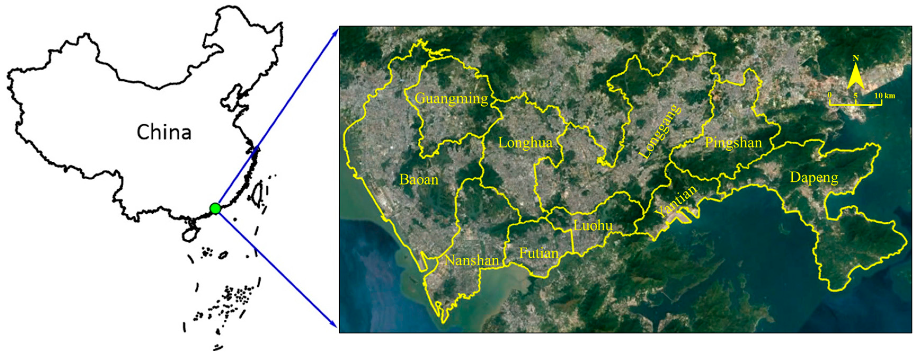
Figure 1.
The location of Shenzhen (source: the authors).

Figure 2.
(a) Percentage of industrial redevelopment projects per community, (b) Percentage of industrial redevelopment projects per 0.5 km × 0.5 km grid, Shenzhen (source: the authors).
Figure 2.
(a) Percentage of industrial redevelopment projects per community, (b) Percentage of industrial redevelopment projects per 0.5 km × 0.5 km grid, Shenzhen (source: the authors).

Figure 3.
Significant statistical spatial clusters of industrial redevelopment projects (at 95% significance level) (source: the authors).
Figure 3.
Significant statistical spatial clusters of industrial redevelopment projects (at 95% significance level) (source: the authors).

Figure 4.
Scatter diagram of industrial redevelopment projects (source: the authors).

Figure 5.
(a) Significant statistical spatial clusters of traditional industrial land redevelopment projects, (b) Significant statistical spatial clusters of new industrial land redevelopment projects (at 95% significance level) (source: the authors).
Figure 5.
(a) Significant statistical spatial clusters of traditional industrial land redevelopment projects, (b) Significant statistical spatial clusters of new industrial land redevelopment projects (at 95% significance level) (source: the authors).


Figure 6.
Spatial distribution density of industrial land transformation into residential space (source: the authors).
Figure 6.
Spatial distribution density of industrial land transformation into residential space (source: the authors).

Figure 7.
Types, scale, and spatial distribution of transferred public facilities land in industrial land transformation.
Figure 7.
Types, scale, and spatial distribution of transferred public facilities land in industrial land transformation.


Table 1.
Land use classification of Urban Planning Standards and Guidelines of Shenzhen City (UPSGS) 2004 and 2014 (source: the authors).
Table 1.
Land use classification of Urban Planning Standards and Guidelines of Shenzhen City (UPSGS) 2004 and 2014 (source: the authors).
| UPSGS (2004) | UPSGS (2014) | ||
|---|---|---|---|
| The First Level | The Second Level | The First Level | The Second Level |
| Commercial land (C) | Commercial service land (C1) | Commercial land (C) | Commercial service land (C1) |
| Commercial office land (C2) | |||
| Service facility land (C3) | |||
| Hotel land (C4) | |||
| Recreational facility land (C5) | Recreational facility land (C5) | ||
| Business apartment land (C6) | Business apartment land (C6) | ||
| Public management and service facility land (GIC) | Administrative office land (GIC1) | Public management and service facility land (GIC) | Administrative management land (GIC1) |
| Cultural relic protection land (GIC22) | Cultural heritage land (GIC8) | ||
| Cultural facility land (GIC2) | Cultural and Sport land (GIC2) | ||
| Sports land (GIC3) | |||
| Medical treatment and sanitation land (GIC4) | Medical treatment and sanitation land (GIC4) | ||
| Educational and scientific research land (GIC5) | Educational facility land (GIC5) | ||
| Religious facility land (GIC6) | Religious land (GIC6) | ||
| Social welfare land (GIC7) | Social welfare land (GIC7) | ||
| Port facility land (GIC8) | Transportation facility land (S) | Regional transportation facility land (S1) | |
| Infrastructure land (U) | Supply facility land (U1) | Supply facility land (U) | Supply facility land (U1) |
| Postal facilities land (U3) | |||
| Telecommunication facility land (U4) | |||
| Environmental sanitation facility land (U5) | Environmental sanitation facility land (U5) | ||
| Construction and maintenance facility land (U6) | Other supply facilities (U9) | ||
| Funeral facility land (U7) | |||
| Other municipal public facility land (U8) | |||
| Public transport land (U21) | Transportation facility land (S) | Traffic station land (S4) | |
| Freight traffic land (U23) | |||
| Rail transit land (U22) | Rail transit land (S3) | ||
| Public refueling station site (U24) | Other traffic facility land (S9) | ||
| Automobile maintenance station (U25) | |||
| Training ground (U26) | |||
| Car wash site (U27) | |||
| Other traffic land (U28) | |||
| External traffic land (T) | Railway land (T1) | Regional transportation facility land (S1) | |
| Highway land (T2) | |||
| Pipeline transportation land (T3) | |||
| Port land (T4) | |||
| Airport land (T5) | |||
| Road and square land (S) | Road (S1) | Urban road land (S2) | |
| Social parking lot land (S3) | Traffic station land (S4) | ||
| Square land (S2) | Green square land (G) | Square land (G4) | |
| Public green space (G1) | Park green space (G1) | ||
| Special use land (D) | Military land (D1) | GIC | Military land (GIC9) |
| Security Department land (D2) | |||
| Storage land (W) | Traditional storage land(W1) | Logistics and storage land (W) | Storage land (W1) |
| Special warehouse land (W2) | Logistics land(W0) | ||
| Storage yard (W3) | - | ||
| Industrial land (M) | Industrial land of Class I (M1) | Industrial land (M) | Traditional industrial land (M1) |
| Industrial land of Class II (M2) | New industrial land (M0) | ||
| Industrial land of Class III (M3) | - | ||
Table 2.
Transformation of industrial land use (source: the authors).
| Land Use Types after Renewal | Number of Plots (n) | Land Area (ha) | Proportion of Total Area (%) |
|---|---|---|---|
| Traditional industrial land (M1) | 53 | 92.87 | 8.1 |
| New industrial land (M0) | 112 | 187.40 | 16.3 |
| Residential land (R) | 166 | 287.45 | 25.0 |
| Commercial and residential Mixed-use land (R+C) | 118 | 264.29 | 23.0 |
| Commercial land (C) | 113 | 142.65 | 12.4 |
| Public facility land (P) | 398 | 173.16 | 15.1 |
| Total | 960 | 1147.82 | 100 |
Table 3.
Land uses of transferred public land (source: the authors).
| Land Use Types | Number of Plots (n) | Land Area (ha) | Average Plot Size (ha/n) |
|---|---|---|---|
| Public management and service facility land (GIC) | 76 | 79.3 | 1.04 |
| Green space land (G) | 257 | 69.11 | 0.27 |
| Transportation facility land(S) | 18 | 6.53 | 0.36 |
| Infrastructure land (U) | 13 | 2.64 | 0.20 |
| Other land (E) | 34 | 15.58 | 0.46 |
| Total | 398 | 173.16 | 0.44 |
Table 4.
Results of Local Moran’s I.
| Type of Projects | Clustering Type | ||||
|---|---|---|---|---|---|
| High-High | Low-High | High-Low | Low-Low | Not Significant | |
| old industrial renewal projects | 182 | 0 | 3 | 0 | 5063 |
| traditional industrial land | 29 | 0 | 2 | 0 | 5217 |
| new industrial land | 76 | 0 | 2 | 0 | 5170 |
© 2020 by the authors. Licensee MDPI, Basel, Switzerland. This article is an open access article distributed under the terms and conditions of the Creative Commons Attribution (CC BY) license (http://creativecommons.org/licenses/by/4.0/).
Share and Cite
MDPI and ACS Style
Lai, Y.; Chen, K.; Zhang, J.; Liu, F. Transformation of Industrial Land in Urban Renewal in Shenzhen, China. Land 2020, 9, 371. https://doi.org/10.3390/land9100371
AMA Style
Lai Y, Chen K, Zhang J, Liu F. Transformation of Industrial Land in Urban Renewal in Shenzhen, China. Land. 2020; 9(10):371. https://doi.org/10.3390/land9100371
Chicago/Turabian StyleLai, Yani, Ke Chen, Jinming Zhang, and Feihu Liu. 2020. "Transformation of Industrial Land in Urban Renewal in Shenzhen, China" Land 9, no. 10: 371. https://doi.org/10.3390/land9100371
Note that from the first issue of 2016, this journal uses article numbers instead of page numbers. See further details here.