1. Introduction
Brownfields are derelict or underused sites that have perceived or real contamination and are primarily located in urban areas that often require intervention to return them to beneficial use [
1]. These sites occur as a result of changes in society that are rooted in a cyclic nature of economic development, the evolving spatial distribution of economic activities and the evolving requirements for the environment we live in [
2].
Brownfields can occur in a variety of locations: urban [
3] or rural [
4,
5]; and a variety of original economic activities: post-housing [
6], post-industrial [
7], post-mining [
8], post-landfill [
9], post-agricultural [
10], post-military [
11] or post-transportation brownfields [
12]. At present, brownfields are at the heart of sustainable development planning [
13] and efforts towards their regeneration are gaining increasing support at all political levels through EU territorial policies as well as the national and local development documents across Europe [
14]. Different nations approach brownfield regeneration with different approaches [
15], which can also vary among regions within a nation [
16,
17,
18]. International attention is focused on brownfield creation and remediation in industrial and highly populated regions, cities and post-mining landscapes [
19,
20]. However, sparsely populated rural areas [
4] contain post-agricultural brownfields that present important obstacles in the development of rural societies [
21]. This phenomenon is ubiquitous in post-socialistic Eastern Europe where collectivized agriculture was adopted during the second half of the 20th century [
22].
A post-agricultural brownfield site is a farm premise once used for collectivized agricultural activities, however is now abandoned and underutilized due to agricultural activities ceasing as a result of societal change [
23]. The post-agricultural brownfields in Eastern European countries are claimed to be the most frequently occurring [
24,
25] and could be found in the vast majority of rural communities [
26], but surprisingly their location and characteristics are less explored and researched. From previous analyses of urban brownfield locations, we know that there are spatial consequences inflicted on nearby areas when brownfields are created, throughout their existence and also through remediation efforts [
27,
28]. Despite those local consequences, brownfield-related issues are often processed at global and national levels and then filtered through regional structures [
29]. The aim of this research is to better understand the spatial consequences of the formation, persistence and reuse of post-agricultural brownfields regarding their creation, existence and remediation in Eastern European countries using the Czech Republic as an example. In the two focus regions, collectivized agriculture was implemented during the second half of the 20th century with great intensity and after the fall of the Iron Curtain, many post-agricultural brownfields were created as these premises were abandoned.
2. Conceptual Background
2.1. Forming of Collective Farming and Its Legacy
In 1948 a communist government took power, and the Soviet-style collectivization of agricultural land and properties was violently introduced in Russian-controlled territories [
30]. This process occurred in the majority of countries behind the Iron Curtain, but its results were impactful in Czechoslovakia with nearly 94% of agricultural land collectivized by the end of the 1950s [
31].
Collective farms and state farms (the latter located especially in borderlands affected by the expulsion of Germans after WWII) represented the primary organizational form of agricultural production on arable land, livestock breeding and rural employment in communist Central and Eastern European (CEE) countries since the 1950s [
32]. The exceptions to this rule could be found in Yugoslavia and Poland where the impacts of the collectivization efforts were rather marginal [
31]. The Soviet model employed in Czechoslovakia can be described as “one village = one farm” and the collectivization process quickly resulted in collective farm creation in every village. These cooperative farms became a central focal point in any village; locals who joined voluntarily or were coerced contributed their land and worked on the premises. As such, everyone in the village either worked in or had close relatives working on the local collective farm. Unacceptably violent practices and forced migrations of opposing farmers to other regions widely destroyed and deformed long-term social structures and relations in rural communities. Moreover, the collectivization built up large agricultural structures that were planned to serve the whole village; large cowsheds, piggeries and operational buildings were built and then severely changed the spatial arrangement of rural communities [
33].
These large collective farm premises have changed the face and design of Czech villages and thus, created the new and sometimes artificial village centers that were not always economically viable, but certainly influential for the local rural population. Even under communist rule, this collective agricultural economic model was difficult to sustain and by the 1970s the cooperative farms were to be merged into even greater and allegedly more prosperous organizational units. Remarkably, the level of employment, the management and the size of the premises remained the same [
32] which undermined any attempt at reform. Paradoxically, the communist propaganda widely utilized the collective farms as examples of successes of the regime [
34], regardless of their success. Movies and TV series positively depicting the structural change in rural areas became hugely popular and affected several generations by creating a widely accepted image of the idyllic rural collective farm.
Restitution and privatization processes in 1991 changed ownership which was then followed by substantial cuts to agriculture subsidies in 1993. These two changes resulted in a rapid restructuring agricultural sector. The large-scale agricultural structural changes were then mirrored in the sharp decline in agricultural employment and concurrent drop of the agricultural share in the gross domestic product [
35]. The present result is shown through the current economic structure of Czech rural areas in comparison to the pre-1989 period. The privatization and restitution of agricultural land and properties occurred very quickly in the Czech Republic, which resulted in the occurrence of millions of new small-scale landowners. However, the quick growth of commercial family farms did not happen [
36] as the majority of the small landowners changed their economic activities or died and their heirs frequently moved to cities or were not interested in practicing agriculture.
Agricultural land has been cultivated especially by great companies [
37,
38] that hire or buy up land. Only about 13% is cultivated by family farmers [
35]. In addition, large agri-companies, plenty of collective farms still exist but with a changed legal status [
36]. These collective farms have generally been transformed into a corporate type of farms as are enterprises with the legal labels of partnerships, joint-stock companies, or limited liability companies. However, corporate farms were suffering from low profitability, high debts and high liquidation or bankruptcy rates [
39], which resulted in a decrease in their numbers [
38]. Economically not so effective agricultural companies and a general decrease in agriculture led to the occurrence of a range of unused or underused premises in the rural [
40,
41].
2.2. Spatial Consequences of Agricultural Change in Post-Socialistic Europe
The diverse trajectories of rural development occurring over a long period in different regions are principally affected by the conditions required for various types of agricultural activities [
42,
43]. However, rural areas are no longer dominated by agricultural ways of life anymore. The economic and social importance of agriculture has been quantitatively lowered in numerous regions [
44]. In these rural spaces, other economic and social connections to agriculture are gradually being built [
45]. The diversification of the rural Czech economic sector is already underway [
46,
47] and shows a path towards more economically viable post-communist agriculture and can sustainably improve the quality of life in these areas [
48].
Since 2004, the Common Agricultural Policy of the European Union has been the most influential factor on Czech agriculture [
46]. The subsidies provided by the policy target agricultural competitiveness within the framework of the agricultural multifunctionality concept. Operational subsidies are typically the only instrument able to keep farms profitable [
38]. However, these were aimed at the diversification in agricultural production and favored growing energy crops (e.g., rapeseed oil) or crops specifically for anaerobic digestion plants (corn maize, fodder plants, etc.) [
49]. The result was a large area of arable lands transitioned towards the cultivation of energy crops, with a simultaneous very large increase in permanent grasslands. The present competitiveness of Czech agriculture is driven by low labor costs at one-third in comparison to the EU15 and low land acquisition of lease costs at about one-fifth of the EU15 prices [
38].
For deeper analyses of spatial consequences of agricultural change in post-socialistic Europe please see other sources, e.g., [
43,
44,
45,
46,
48,
50,
51,
52,
53,
54].
2.3. Changes in the Agricultural Sector in the Czech Republic
The occurrence of post-agricultural brownfields, their abandonment and reuses of agricultural premises are deeply rooted in the agricultural transformation. This transformation can be traced back to the fall of the Iron Curtain in the year 1989 when the Communist regime collapsed, which in turn prompted social, political, cultural and agricultural changes.
During the Communist era on the principles of central planning ruled the agricultural sector with very limited space intended for the development of market relations that existed naturally but were not legal and thus hidden in a shadow economy. In this period, the use of agricultural land was dominated by the large-scale agricultural farms that were originally founded in the 1950s. Residents were often violently made to join a local agricultural cooperative managed by the local Communist party leaders. Land and agricultural properties owned by individual families were collectivized and ownership was transferred to the local Soviet-style cooperative where farmers were allowed to work [
55]. Farmers who opposed these dire measures were resettled to another part of the country and their children were prevented from getting a higher education. The collectivization process resulted in dramatic changes in social structures in rural regions [
56]. As a result of these policies, the majority of agricultural land was owned by agricultural cooperatives and only small sections of land in border regions were managed by the state as state farms. The differences among both ownership types are negligible because the former owners and independent farmers of those lands were typically employed on either type of farm, instead of working their own lands. Only a limited number of independent farms survived this period, mainly located in the mountains in the eastern part of the Czech Republic.
The communist plans were designed to develop complex agricultural programs that combine both crop and animal husbandry farming without regard to where the collectivized farm was located. Such centralized policies un-adapted to local conditions led to unstable economic results. Consequently, fertilizers were widely utilized and supported so that the uneven quality of agricultural land was more balanced [
57]. Furthermore, a system of financial contributions from the central government to under-performing farm cooperatives was developed to even out production differences among the collectivized premises. This system led to the lack of interest to manage the land properly and resulted in the overuse of chemical fertilizers, increased environmental hazards and the complete disregard for the natural conditions of the agricultural lands [
58].
In the late 1980s, more than 550,000 people were employed in Czech agriculture. This figure has recently dropped to around 100,000 (2.6% of the economically active population). A very similar trend can be found for the share of agriculture in the gross value added generated in the economy of the Czech Republic; that has dropped to 1.3% [
49]. Agriculture in the Czech Republic has changed also in the structure of its production. From the long-term perspective, the number of livestock breeding operations has been systematically declining—three-fifths of cattle have disappeared [
47], the number of pigs was halved [
46]. Potatoes have been replaced by oilseed rape, which has become the second most common crop. Diversification trends in the economic activities of agricultural farms showed significant development both in agricultural activities and non-agricultural activities (e.g., agritourism, on-site food processing and sales of agricultural products) [
45].
After the fall of the Iron Curtain, the process of returning land to the original owners and privatization also occurred [
59]. However, an overwhelming majority of the original farmers were too old to re-start farming on their returned land and their descendants who preferred to live in cities were developing careers in other sectors of the economy and rarely returned to agricultural work [
60]. Compounding the problem was that the government preferred to support the transformation of large-scale collectivized agricultural farms into newly established agricultural businesses [
61]. As a result, large-scale agricultural farms have survived until the present day [
62], which makes the average size of farms in the Czech Republic set at 130 hectares the largest in the European Union where the average size of farms is around 16 hectares. Currently, 90% of available agricultural land is managed by farms with more than 50 hectares. The present-day ownership structure of agricultural lands is such that 20% is farmed by agricultural cooperatives, while 50% is farmed by agricultural business companies and less than 30% is managed by individual farmers.
2.4. Post-Agricultural Brownfields
Post-agricultural brownfield’s origins are found on the oversized premises of former communist agricultural cooperatives and state farms whose competitiveness collapsed in the early 1990s as a result of reforms in agricultural policies [
35]. These collectivized agricultural farms operating on large premises were not able to compete in new economic conditions and were abandoned, which resulted in the occurrence of underused post-agricultural brownfields that have been accumulating since 1989 [
63].
The rural population reflects the issue of post-agricultural brownfields in terms of their decay. Multiple levels of government are taking gradual steps to reduce their occurrence. A wide variety of brownfield remediation projects and efforts are proposed with traditional and alternative reuses suggested [
64,
65,
66]. Despite the many remediation efforts, numerous long-term brownfields represent a spatial barrier against development in those communities.
The general driving forces that lead to the occurrence of brownfields are usually similar across regions, such as the cyclic development of economies and general tendencies to shift certain branches of the economy to cheaper countries. However, the regional perspective is still important. This is our motivation when defining the main objective of this paper; this research will evaluate the spatial clustering of post-agricultural brownfields over a fourteen-year period between 2004–2018. Our first aim is to identify potential spatial clusters of post-agricultural brownfields (1) originating before 2004, (2) after 2004 up to 2018, (3) remediated between 2004 and 2018 and (4) remain long-term brownfields. The second aim is to reveal how communities and spatial clusters that contain post-agricultural brownfields differ socio-economically from those areas without.
3. Materials and Methods
Several different datasets were required to be prepared to fulfil the aim of our study. First, the spatial distribution of post-agricultural brownfields in 2004 and 2018 was collected. Then, the use of the 2004 brownfields in 2018 was ascertained. Then, socio-economic and environmental characteristics of the host communities were obtained from freely accessible data sources. In addition, finally, data analyses including spatial analyses and regression analyses were employed to better understand the non-randomness of agricultural brownfields location.
3.1. Study Area
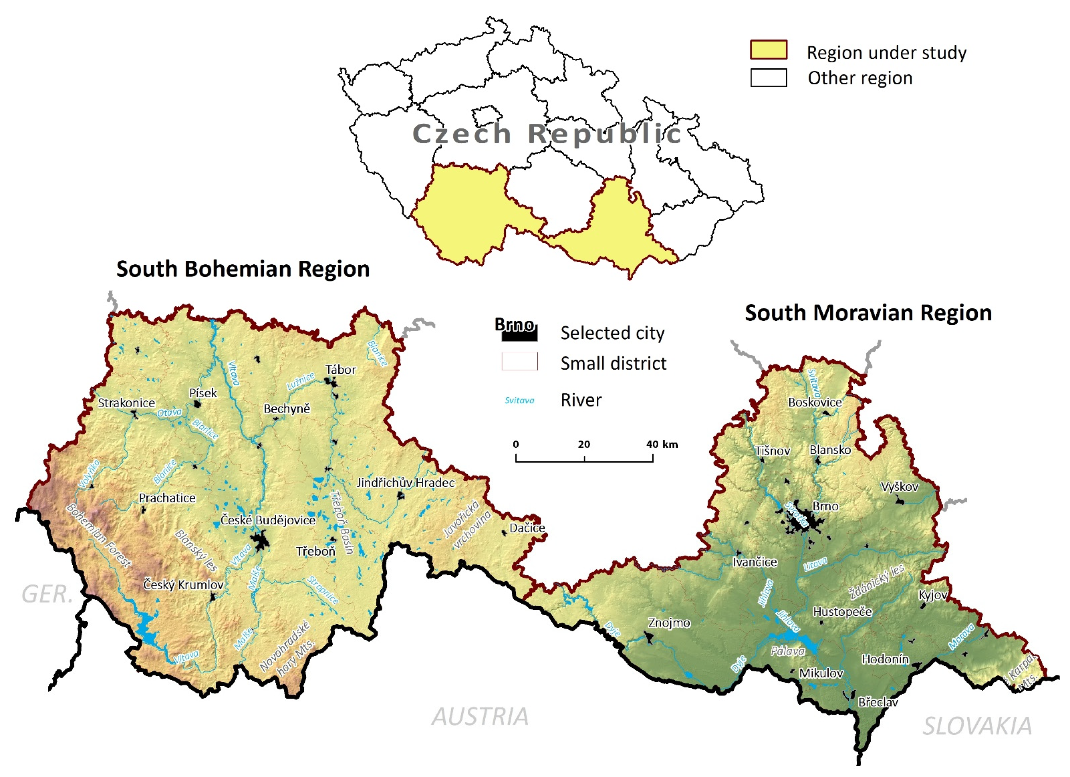
The two regions situated in the southern part of the Czech Republic along the border with Austria, Germany and Slovakia (
Figure 1) were selected for our research. We have selected the South Bohemian Region covering 10057 km
2 and the South Moravian Region covering 7188 km
2 for the reasons below:
Both regions are predominantly rural but with different natural conditions that also impart differing abilities upon the land to support agricultural activities. While the agricultural landscape of the South Moravian Region is primarily plains with high-quality soils, the South Bohemian Region is more differentiated with hillier terrain and farmers in this region commonly follow post-productive approaches.
Diverse natural conditions for agriculture are reflected in distinct ways of organization of agriculture in both regions. While in the South Bohemian Region larger farms can be found (an average farm size was 141 hectares in 2016), in the South Moravian Region agriculture is practiced by rather smaller farmers (94 hectares on average in 2016). Even more distinct differences in farm sizes can be detected if just farms owned by individual persons (not business companies) are considered (these farms are twice larger in the South Bohemian Region) [
67].
The share of arable land in the South Moravian Region is 78.8% and is much higher than the Czech average of 70.2%, but the South Bohemian Region average of 68.1% is below the Czech average (
https://www.czso.cz/documents/10180/23192368/obce_2009_2019.xlsx accessed on 19 February 2021). The opposite is true for pastures and meadows in these communities with the South Moravian Region having less than the Czech average and the South Bohemian Region having more than the average. The South Bohemian Region is one of the most important regions for food production in the Czech Republic for potatoes, milk or beef. The South Moravian Region is one of the most important regions in the Czech Republic for the production of fruits, vegetables, corn, sunflower, or wine [
68].
The level of employment in agriculture is well above the Czech average of 2.7% in both regions with the South Bohemian Region reporting 5.4% and the South Moravian Region recording 2.9% [
68]. Agriculture is an integral part of both regional economies with a comparable share of leased land (20% own land, 29% leased from firm members, 51% leased from other landowners) [
69].
The shape and scale of rural communities significantly differ in the two studied regions. South Bohemian Region has many varied small rural settlements closely tied to local agriculture, South Moravian landscape has larger rural communities [
70] where productive agriculture is traditionally a vital part of local culture.
Another difference can be detected in the extent and regional importance of organic farming. While in the South Bohemian Region almost one-fifth (18.3%) of agricultural land is sustainably cultivated, where that number falls to 5% in the South Moravian Region; organic farming is practiced four times often in the South Bohemian Region.
3.2. Spatial Data
The topographic maps from the late-1980s and mid-1990s of Czechoslovakia at 1:25,000 scale were used to identify pre-1989 agricultural premises in all of 1,297 communities as they were found to be appropriate in a pilot study [
23]. The sites considered to be pre-1989 agricultural premises of former collective farms and state farms were labeled on these maps as agricultural properties, cowsheds, pig farms, sheepfolds, poultry farms, horticultural fields and stud farms. Black and white aerial imagery from the early 1990s were used to delimit the borders of these premises [
26]. The spatial accuracy of these images is circa 10 m. The maps and aerial imagery available from the map archives of the Institute of Geonics, the Czech Academy of Sciences were used.
The selected uses for areas of former collective farms and state farms that were brownfields in 2004 persisting in 2018 and new brownfields between 2004 and 2018 were spatially delimited for two-time horizons—years 2004 and 2018. Land-use information was gathered from aerial images that cover the area of the whole Czech Republic with free access through web map services (WMS) of the Czech Office for Surveying, Mapping and Cadastre (WMS—Orthophoto:
https://geoportal.cuzk.cz/WMS_ORTOFOTO_PUB/WMService.aspx accessed on 19 February 2021; and WMS—Archival photo:
https://geoportal.cuzk.cz/WMS_ORTOFOTO_ARCHIV/WMService.aspx? accessed on 19 February 2021) [
71]. Brownfields in the year 2004 within each pre-1989 agricultural premises were identified as abandoned spaces on color aerial imagery (WMS—Archival photo) taken between the years 2003 and 2005 [
71]. Brownfields identified within the borders of the pre-1989 agricultural premises were delimited as abandoned parts where signs of continual use were not present in the imagery, such as abandonment of access roads and/or pathways used formerly for servicing buildings, ruined buildings and uncontrolled waste dumping. This method of delimitation of post-agricultural brownfields was found by a preliminary study as accurate enough for this type of study [
23]. The year 2004 was chosen because it was the year that the Czech Republic joined the European Union and part of the Common Agricultural Policy and substantial changes in the Czech agricultural system occurred [
46,
47]. Applying the same delineation method on imagery taken between 2016 and 2018 (WMS—Orthophoto) yielded data on brownfields emerging after the year 2004 as well as data on reuses of brownfields identified in the year 2004 [
71], where only the areas identified in 2004 were examined for reuses. Reuses have many different visual expressions, such as repair of ruined buildings, resumption of road use, demolition of ruined buildings, construction of new buildings, soil cultivation. Where this was unclear additional panoramic imagery available via the website application Mapy.cz and street view function of Google Maps were used to resolve the issue. The suitability of such a procedure has been proven before [
23]. This method is not appropriate for the precise identification of detailed reuse types for every single brownfield, but for our purposes, this methodology is suitable [
21].
All data were tabulated for each community to make comparisons between the spatial data of post-agricultural brownfields and the socio-economic and environmental data for communities.
3.3. Socio-Economic and Environmental Data
Characteristics of communities used in this research are based on the previous studies aimed at understanding the ongoing agricultural change [
49] and the typology of development potential of the rural areas [
70]. The data we used for the community characteristic is based on freely accessible data gathered by the Czech Statistical Office, i.e., analytical data from the year 2018 (directly accessible here:
https://www.czso.cz/documents/10180/23192368/obce_2009_2019.xlsx accessed on 19 February 2021) and the data from the 2011 Census (directly accessible here:
https://vdb.czso.cz/vdbvo2/faces/en/index.jsf accessed on 19 February 2021, “All About Territory” was chosen and then all communities within the study area). The average basic price of agricultural land in CZK is based on Regulation no. 298/2014. Agricultural production areas (Corn AAP, Sugar-beet AAP, Grain AAP, Potato AAP and Fodder crops AAP) are based on Regulation no. 178/1994 and Regulation no. 215/1995. All characteristics of communities used in further analyses can be found in
Appendix A (
Table A1).
3.4. Data Analyses
The data analysis occurred in two principal steps. The aim of the first step was to identify spatial clusters of communities with a statistically higher and statistically lower probability for the occurrence of four phenomena under study:
Brownfields occurring in the year 2004,
Reused areas in 2018 of brownfields occurring in the year 2004,
Long-term occurring brownfields (in 2018 not reused brownfields from the year 2004),
New brownfields established after the year 2004 until 2018.
The second step employed the regression of independent variables (from
Table A1) to determine which are important for differentiation between communities with high and low concentration of the four brownfield-related cases.
Firstly, a Global Moran’s I was calculated to test randomness in the spatial distribution of the four above-mentioned brownfields-related cases. The Global Moran’s I is a variation of the Pearson correlation coefficient used to test for the presence of spatial autocorrelation in the data space. If the Global Moran’s I is statistically significant, we can assume the brownfield data is spatially clustered and we can refuse a null hypothesis that they are distributed randomly. If the Global Moran’s I is significant, then the Anselin Local Moran’s I method can be used to identify if neighboring areas (in our case communities) show alike high or low values in our test variables: the area of brownfields in the year 2004, reused brownfields, long-term occurring brownfields and new brownfields established after the year 2004. To show a spatial pattern of the distribution, a Kernel density estimation was completed for each respective brownfield-related issue [
72]. The Global Moran’s I, the Anselin Local Moran’s I and the Kernel density estimation were calculated in the ArcGIS 10.3 software [
73] and are presented in the Results section.
The potential differences between two types of communities (high-high and low-low) revealed by the Anselin Local Moran’s I were used for further analyses. The high-high communities were found by the Anselin Local Moran’s I as neighboring communities with statistically higher values (than expected under random conditions of spatial distribution) for respective brownfield cases under study. The low-low communities were found by the Anselin Local Moran’s I as neighboring communities with statistically lower values (than expected under random conditions of spatial distribution) for respective brownfield-related issues under study. The differences between high-high and low-low communities were analyzed by logistic regression using a logit link wherein the high-high and low-low communities are the binary dependent variable. A forward selection of independent variables (listed in
Appendix A Table A1) was used to limit independent variables to only those with a unique significant influence on the dependent variable. The statistical importance of the whole model was tested using the Hosmer–Lemeshow test for goodness of fit [
74] and the data fit the model was determined by Cox–Snell pseudo R
2 [
75]. The statistical importance of independent variables was tested by the type III likelihood test and the Wald test. Each regression coefficient (i.e., its difference from zero value) was tested by the Wald statistics [
76]. Its importance was assessed by the standard error (s.e.) of this estimation and the significance (the p-value) of the Wald test. The logistic regression calculations were performed in the Tibco Statistica software [
77].
4. Results
We were looking for pre-1989 premises of collectivized agriculture in all the 1297 villages of both the South Bohemian Region and the South Moravian Region. We have found pre-1989 premises of collectivized agriculture in 1221 communities (94% of all communities). The total area of those pre-1989 agricultural premises in 1221 communities was 80.65 km
2. The existence of post-agricultural brownfields in 2004 was found in 832 communities (68% of communities with pre-1989 agricultural premises) with a total area of 13.13 km
2 (16% of the total area of pre-1989 agricultural premises). New brownfields between 2004 and 2018 occurred in 542 communities with a total area of 7.04 km
2. Persistent brownfields, as in brownfields that existed both in 2004 and 2018, were found in 625 communities with a total area of 6.29 km
2. Conversely, reused brownfields were found in 595 communities and the total area of regenerated brownfields between 2004 and 2018 is 6.84 km
2. Please note, that the sum of the number of communities with long-term brownfields and with reused brownfields is higher than the number of communities with brownfields in 2004. This is because in one community some brownfields remained brownfields but others were reused; the sum of the area of long-term brownfields and area of reused brownfields is equal to the area of brownfields in 2004 (for data, please see
Table S1).
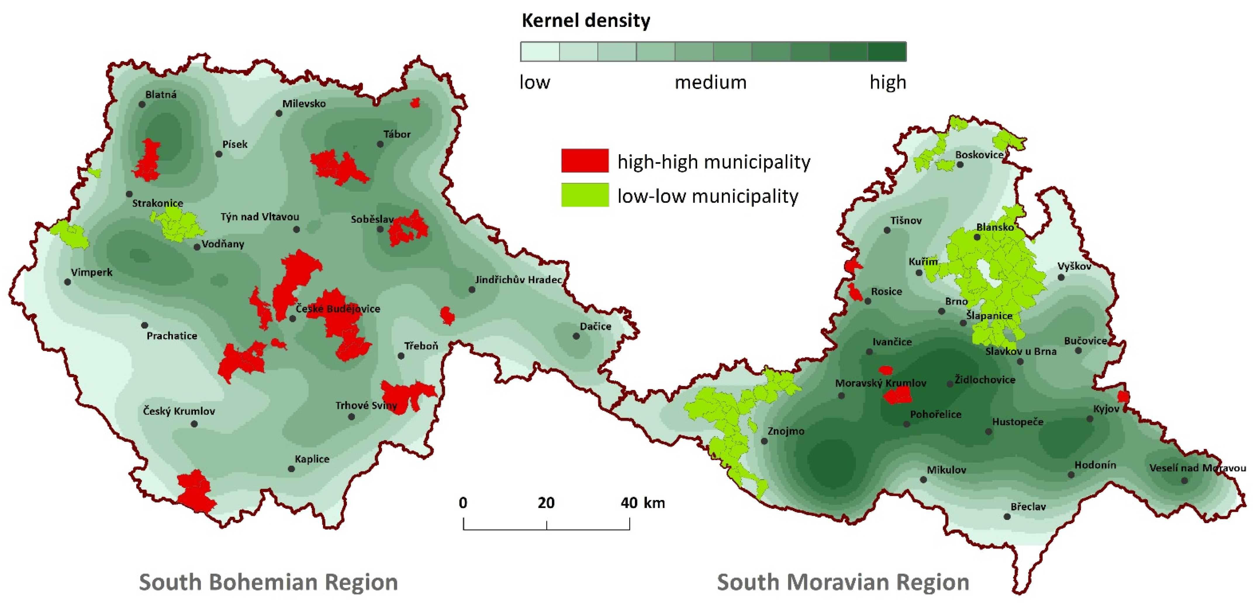
4.1. Post-Agricultural Brownfields in 2004
The spatial distribution of post-agricultural brownfields existing in 2004 can be considered clustered; the resultant z-score of 1.886 is slightly above the
p-value of 0.058. These sites are located in peripheral urban and industrial centers of South Bohemia and mostly České Budějovice, which is the largest urban center in the region and then also around other industrial centers (
Figure 2). On the contrary, compact regions where a low concentration of post-agricultural brownfields until 2004 was revealed, could be found westward to Znojmo, a regional center close to the border with Austria (see
Figure 2) as well as in the eastern and northeastern hinterland of Brno (the largest urban center of South Moravia, see
Figure 1).
The forward selected variables used in the logistic regression model of the socio-economic and environmental data indicated six variables to be important in the differentiation between the high-high (neighboring communities with statistically higher values for respective brownfield cases under study) and low-low (neighboring communities with statistically lower values for respective brownfield-related issue under study) communities (
Table 1). Communities with the high-high location of post-agricultural brownfields in 2004 were those where less native population can be found, with a higher average age of the population and a lower share of built-up areas in the land-use structure. In these communities, we would find less areas covered by the forests and a higher share of permanent grasslands, as well as a lower number of houses designated for tourism (
Table 2). The relation between these variables is shown through the model fitting data as well as the percentage of explained variability that is very high (as Cox-Snell pseudo R
2 is equal to 0.413).
4.2. Remadiated Post-Agricultural Brownfields during 2004–2018
The spatial distribution of remediated post-agricultural brownfields during 2004–2018 does not seem to show the tendency to spatial clustering as a z-score is 1.439 with p = 0.150. Their distribution is random without any detectable spatial pattern.
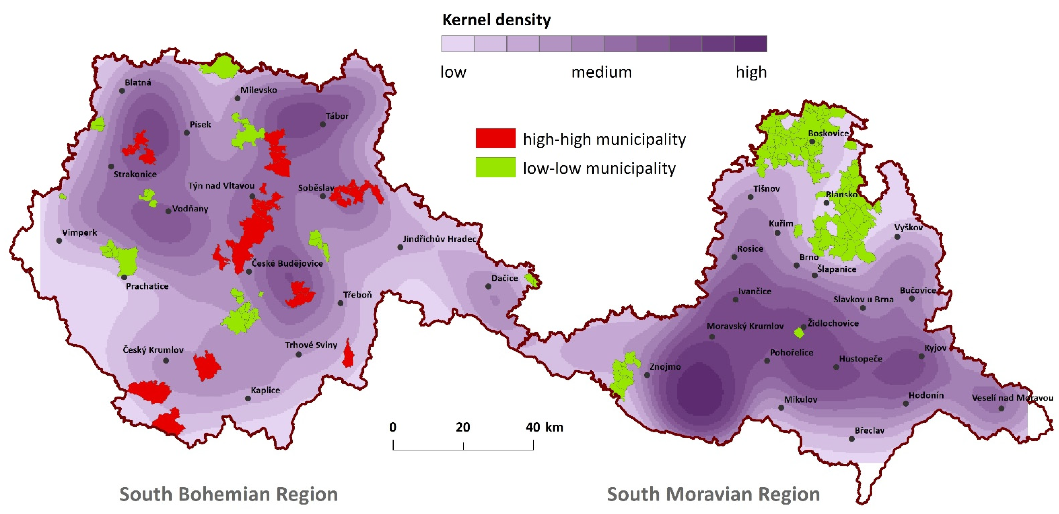
4.3. Long-Term Post-Agricultural Brownfields
Non-remediated and therefore long-term post-agricultural brownfields tend to be spatially more visibly clustered (the value of a z-score of the Global Moran’s I is 2.011 and is significant,
p = 0.044). These long-term, non-remediated post-agricultural brownfields can be primarily found in many peripheral locations of the South Bohemian Region (
Figure 3). Spacious regions without the occurrence of long-term post-agricultural brownfields were revealed in vast areas north of the regional center of Brno. Another region without long-term brownfields was around České Budějovice (regional center of South Bohemia, see
Figure 1).
Spatial clusters of communities with a high-high spatial occurrence of the long-term (non-remediated) post-agricultural brownfields are concentrated in the potato-growing agricultural production area. Other features that are typical for these high-high areas are a lower share of arable land, which signals areas in higher altitudes and hilly areas. In these areas, the population has increased since the year 2004 and university-educated people are relatively less present there (
Table 3 and
Table 4). The model explains a high percentage of variability (Cox–Snell pseudo R
2 is equal to 0.498).
4.4. New Brownfields Occurred after the Year 2004
The occurrence of newer post-agricultural brownfields (those sites occurring after the year 2004) forming large spatial clusters and report a z-score of the Global Moran’s I 9.168 and significant at
p < 0.0001. In comparison to the occurrence of brownfields until the year 2004, new brownfields are newly occurring in several spacious clusters in the South Moravian Region (
Figure 4). In contrast, the regions without the detected occurrence of new post-agricultural brownfields (= low-low regions) are spread on the substantial part of South Bohemia and form four large areas (
Figure 4).
The type of agricultural production area where the communities are located was found by the logistic regression as the most important factor that differentiates the clusters of high-high regions from low-low regions. The communities with statistically bigger areas of newer brownfields are primarily situated in the corn-growing agricultural production areas (
Table 5 and
Table 6). Secondly, the ageing of the population in the communities was shown to be an important differentiating factor. The influence of the mentioned variables is substantial, and the resulting model explains an extremely high percentage of variability in the affiliation of the communities to particular clusters (Cox–Snell pseudo R
2 is equal to 0.636).
5. Discussion
The spatial distribution of the four post-agricultural brownfield-related issues under study were tested for randomness and three of those show a concentrated non-random spatial pattern. We revealed that the occurrence of post-agricultural brownfields existing in the year 2004 was concentrated in the areas with a lower quality of soils and those areas situated on the periphery of larger towns in the South Bohemia Region and especially the regional center of České Budějovice (
Figure 1 and
Figure 2). Generally, we would find these sites in communities that are less suitable for highly productive agricultural activities [
45]. In addition, yet at the same time, these communities are also where there is pressure applied towards their quick reuse as they are situated in locations with higher accessibility [
40]. Conversely, spatial clusters without the occurrence of post-agricultural brownfields in 2004 are detectable in the communities that are highly covered by the forests, are near the upper-regional center of Brno and are frequently utilized for recreation, regions such as the highlands north of Brno, the region along the Dyje River and adjacent regions (
Figure 1 and
Figure 2). These results might reflect a higher pressure for brownfield reuse in the regions with more attractive leisure activities as well as suburban housing.
The location of post-agricultural brownfields remediated between 2004 and 2018 has a random spatial pattern. The location of the remediated brownfields is perhaps more affected by its unique characteristics (such as, e.g., ownership) than by its spatial characteristics. Indeed, the spatial pattern does not seem to be important and instead, it is more likely local social and cultural context that is more relevant.
Peripheral communities located further from urban centers remain burdened by long-term brownfields. The long-term non-remediated post-agricultural brownfield clusters are primarily visible in the South Bohemian Region. While this type of brownfields exists in the South Moravian Region too, but the clusters of adjacent communities with these sites were not detected. In South Bohemia, the long-term brownfields are more frequently found in peripheral regions [
78]. These localities are situated in rural communities distant from regional urban centers with poor accessibility and, thus, a lower level of connectivity [
40,
79]. The communities are far from economic centers which affect their economic performance. The conditions for practicing productive agriculture are rather low as these localities and typical of the higher altitudes in these locales [
80]. An interesting result is that low-low regions were detected in the proximity of some urban centers of South Bohemia. Especially the case of České Budějovice which is a good example of successful efforts made in brownfield remediation [
81]. As a result of the economic strength of this regional economic center, plenty of post-agricultural brownfields around the city have been already remediated [
23]. There is no doubt that České Budějovice is not among the largest economic centers in the Czech Republic (ranked 7th in population), while its regional economic strength affects the reuse of brownfields [
81].
New post-agricultural brownfields that emerged after the year 2004 are principally located in highly productive agricultural regions where corn is grown. Not all the corn-growing areas can be included, but these newly emerged brownfields are not randomly located and are concentrated into clear spatial clusters. In the South Bohemian Region, this phenomenon might be linked to the change of the brownfield reuse strategy that is applied when a new owner or tenant starts their activities in the site (personal observation). If we focus on our analytical results of the newly established post-agricultural brownfields occurring after the year 2004, no link to individual agricultural companies can be found. Spatial clusters of the communities with (and without) new brownfields are spacious and likely cover the majority of the regions where pre-1989 communist agricultural cooperatives were operating.
6. Conclusions, Limitations and Further Research
The main aim of this research was to deepen our knowledge regarding creation, existence and remediation of post-agricultural brownfields in Eastern European countries using two different agricultural regions of the Czech Republic as an example. Analysis of original data on the spatial distribution of post-agricultural brownfields showed statistically significant spatial clustering for brownfield creation until the year 2004 as well as brownfield creation between the years 2004 and 2018. Similarly, spatial clustering was detected in the case of long-term post-agricultural brownfields existing in 2004 and persisting through 2018. However, communities with already remediated post-agricultural brownfields were not found to be clustered—their spatial distribution is random. Interesting coherences among the occurrence, abandonment and reuse of post-agricultural brownfields are shown in these results. They present another perspective on the dynamics and manifestations of agricultural change and the rural transition that the Czech Republic experienced in the period after the fall of the Iron Curtain. Spatial expressions of agricultural transition seem to be reflected in the variety of destinies of post-agricultural brownfields and their reuses.
While the occurrence of post-agricultural brownfields until the EU accession in the year 2004 is typical for agricultural communities with soils of poor quality in the South Bohemian Region and on the periphery of its regional urban centers, in the South Moravian Region the occurrence of post-agricultural brownfields seems to be delayed. The sites emerging after the EU accession were primarily located in agricultural communities with high soil quality. Specifically, this is the case for the regions in the corn-growing agricultural production areas. Long-term non-remediated post-agricultural brownfields can be most frequently found in both outer and inner peripheral locations of the South Bohemian Region. This research revealed that a country-wide process connected to the agricultural change and transition has manifested surprisingly varied manners in different communities. It seems that particular communities and their socio-economic and environmental specifics filter and deform transitional pressures from upper-regional levels. Individual communities and their regional contexts have been considered the modulators of agricultural change.
According to our results, some important limitations of the present study must be stated. In our analyses we did not intend to resolve the exact location in a Cartesian sense of space and its ties to remediation or abandonment. Our aim here was to find out if there are any spatial irregularities in the creation of four brownfields-related cases, brownfields occurring in the year 2004, reused areas in 2018 for brownfields occurring in the year 2004, long-term occurring brownfields and new brownfields established after the year 2004 until 2018. Additionally, we explored if there are any ties to these cases to characteristics of the host communities where these brownfields are located. The independent variables were capable of accounting for the overall circumstances of agricultural brownfields, but not of individual farms. To do this, other surveys focused on the individual circumstances of pre-1989 premises of collectivized agriculture are needed.
Our work indicates that further research is required to better understand the lack of spatial clustering of remediated post-agricultural brownfields. The location seems to have little influence on their reuse and dependent on processes beyond the regional scale. Additionally, the influence of the ownership structure on post-agricultural brownfields exceeds the importance of regionally-rooted processes. The remediation efforts made on these sites, however, are not random but spatial patterns were not detected. A case-by-case approach examining individual remediation projects should be applied and with further analyses, a behavioral pattern can be revealed using qualitative social science methodologies.
Supplementary Materials
The following are available online at
https://www.mdpi.com/2073-445X/10/3/325/s1, Table S1: Areas of brownfields in 2004 (BR2004), brownfields in 2018 but not existed in 2004 (BR2018), brownfields that existed both in 2004 and 2018 (BR_OLD) and reused brownfields between 2018 and 2004 (REUSED), COM_ID is the code of municipality according to the coding of the Czech Statistical Office.
Author Contributions
Conceptualization, J.N. and T.K.; methodology, T.K. and J.N.; formal analysis, T.K.; resources, J.N., T.K. and S.M.; data curation, T.K.; writing—original draft preparation, J.N., T.K., S.M., R.J.F., P.K., K.P., J.Š. and R.O.; writing—review and editing, J.N., S.M. and R.J.F.; visualization, T.K.; supervision, J.N. and R.J.F.; project administration, P.K.; funding acquisition, J.N. All authors have read and agreed to the published version of the manuscript.
Funding
This research was funded by Czech Science Foundation, grant number 19-23870S.
Acknowledgments
The authors would like to thank three anonymous reviewers for their insightful comments that helped substantially improved our study. The authors would also like to thank the Czech Cadastral office for access to aerial photos.
Conflicts of Interest
The authors declare no conflict of interest.
Appendix A
Table A1.
Characteristics of communities used in regression analyses.
Table A1.
Characteristics of communities used in regression analyses.
| Variables | Data Sources |
|---|
| Population with maximum primary education (2011) (%) | 1 |
| Population with a university education (2011) (%) | 1 |
| Economically active population working in agriculture, forestry, and fisheries (2011) (%) | 1 |
| Percent of the economically active population working in accommodations, food services, and hospitality (2011) | 1 |
| Portion of recreation houses on houses (2018) (%) | 2 |
| Change in houses built or reconstructed (2018/2009) (%) | 2 |
| Change in population 2018/2009 (%) | 2 |
| Population below 15 years old (2018) (%) | 2 |
| Change in population below 15 years old (2018/2009) (%) | 2 |
| Population above 60 years old (2018) (%) | 2 |
| Change in population above 60 years old (2018/2009) (%) | 2 |
| Polupation (2018) | 2 |
| Average age (2018) | 2 |
| Change in average age (2018/2009) (%) | 2 |
| Age index (2018) | 2 |
| Change in age index (2018/2009) (%) | 2 |
| Native population % (2011) | 1 |
| Net migration (2011) | 1 |
| The average basic price of agricultural land | 3 |
| Portion of agricultural land on total area of the community (2018) (%) | 2 |
| Portion of forests on total area of the community (2018) (%) | 2 |
| Portion of bulit-up areas on total area of the community (2018) (%) | 2 |
| Portion of arable land on agricultural land (2018) (%) | 2 |
| Portion of pastures and meadows on agricultural land (2018) (%) | 2 |
| Agricultural production area—Grain | 4 |
| Agricultural production area—Potatoes | 4 |
| Agricultural production area—Fodder Crops | 4 |
| Agricultural production area—Corn | 4 |
| Agricultural production areaSugar—beet | 4 |
References
- CEN. Glossary of Terms for Holistic Management of Brownfield Regeneration (GoT-HOMBRE); European Committee for Standardization: Brussels, Belgium, 2014; p. 16. [Google Scholar]
- Kunc, J.; Martinat, S.; Tonev, P.; Frantal, B. Destiny of urban brownfields: Spatial patterns and perceived censequences of post-socialistic deindustrialization. Transylv. Rev. Adm. Sci. 2014, 10, 109–128. [Google Scholar]
- Haase, A.; Herfert, G.; Kabisch, S.; Steinfuhrer, A. Reurbanizing Leipzig (Germany): Context Conditions and Residential Actors (2000–2007). Eur. Plan. Stud. 2012, 20, 1173–1196. [Google Scholar] [CrossRef]
- Sardinha, I.D.; Craveiro, D.; Milheiras, S. A sustainability framework for redevelopment of rural brownfields: Stakeholder participation at SAO DOMINGOS mine, Portugal. J. Clean. Prod. 2013, 57, 200–208. [Google Scholar] [CrossRef]
- Van der Horst, D.; Martinat, S.; Navratil, J.; Dvorak, P.; Chmielova, P. What can the location of biogas plants tell us about agricultural change? A Case Study from the Czech Republic. DETUROPE Cent. Eur. J. Reg. Dev. Tour. 2018, 10, 33–52. [Google Scholar]
- Rall, E.L.; Haase, D. Creative intervention in a dynamic city: A sustainability assessment of an interim use strategy for brownfields in Leipzig, Germany. Landsc. Urban Plan. 2011, 100, 189–201. [Google Scholar] [CrossRef]
- Kunc, J.; Navratil, J.; Tonev, P.; Frantal, B.; Klusacek, P.; Martinat, S.; Havlicek, M.; Cernik, J. Perception of urban renewal: Reflexions and coherences of socio-spatial patterns (Brno, Czech Republic). Geogr. Tech. 2014, 9, 66–77. [Google Scholar]
- De Sousa, C.A. Turning brownfields into green space in the City of Toronto. Landsc. Urban Plan. 2003, 62, 181–198. [Google Scholar] [CrossRef]
- De Sousa, C.A. Unearthing the benefits of brownfield to green space projects: An examination of project use and quality of life impacts. Local Environ. 2006, 11, 577–600. [Google Scholar] [CrossRef]
- Krejci, T.; Klusacek, P.; Martinat, S.; Havlicek, M. Introductory Research Notes on Fate of Sugar-Industry-Brownfields in Czech Republic. Listy Cukrov. A Reparske 2014, 130, 406–411. [Google Scholar]
- Klusacek, P.; Martinat, S.; Krejci, T.; Bartke, S. Re-development of a former military training area-The case of Brdy told from a local actors’ perspective. Land Use Policy 2019, 82, 147–157. [Google Scholar] [CrossRef]
- Zhang, C.; Dai, S.J.; Xia, H.S. Reuse of Abandoned Railways Leads to Urban Regeneration: A Tale from a Rust Track to a Green Corridor in Zhangjiakou. Urban Rail Transit. 2020, 6, 104–115. [Google Scholar] [CrossRef] [Green Version]
- Kretschmann, J. Post-Mining-a Holistic Approach. Min. Metall. Explor. 2020, 37, 1401–1409. [Google Scholar] [CrossRef]
- Matkovic, I.; Jakovcic, M. Brownfield areas and their regeneration definitions and approaches. Prostor 2019, 27, 349–359. [Google Scholar] [CrossRef]
- Kotval-K, Z.; Meitl, C.; Kotval, Z. Should the public sector play a greater role funding brownfield redevelopment projects? A transatlantic comparison. Int. Plan. Stud. 2017, 22, 366–383. [Google Scholar] [CrossRef]
- Cao, K.; Guan, H. Brownfield redevelopment toward sustainable urban land use in China. Chin. Geogr. Sci. 2007, 17, 127–134. [Google Scholar] [CrossRef]
- Newton, P.W. Beyond greenfield and brownfield: The challenge of regenerating Australia’s greyfield suburbs. Built Environ. 2010, 36, 81–104. [Google Scholar] [CrossRef]
- Portney, K. Civic engagement and sustainable cities in the United States. Public Adm. Rev. 2005, 65, 579–591. [Google Scholar] [CrossRef]
- Yu, J.; Pei, L.L. Investigation of a Brownfield Conflict Considering the Strength of Preferences. Int. J. Environ. Res. Public Health 2018, 15, 393. [Google Scholar] [CrossRef] [Green Version]
- Zhang, X.; Song, Y.; Wang, S.; Qian, S. Exploring Research Trends and Building a Multidisciplinary Framework Related to Brownfield: A Visual Analysis Using CiteSpace. Complexity 2021, 2021. [Google Scholar] [CrossRef]
- Klusáček, P.; Navrátil, J.; Martinát, S.; Krejčí, T.; Golubchikov, O.; Pícha, K.; Škrabal, J.; Osman, R. Planning for the future of derelict farm premises: From abandonment to regeneration? Land Use Policy 2021, 102. [Google Scholar] [CrossRef]
- Bezak, P.; Mitchley, J. Drivers of change in mountain farming in Slovakia: From socialist collectivisation to the Common Agricultural Policy. Reg. Environ. Chang. 2014, 14, 1343–1356. [Google Scholar] [CrossRef]
- Navratil, J.; Martinat, S.; Krejci, T.; Picha, K.; Klusacek, P.; Skrabal, J.; Osman, R. The fate of socialist agricultural premises: To agricultural ‘brownfields’ and back again? Morav. Geogr. Rep. 2019, 27, 207–216. [Google Scholar] [CrossRef] [Green Version]
- CzechInvest. Základní Statistické Výsledky Vyhledávací Studie Brownfieldů (Basic Statistical Results. Brownfield Search Study); Ministry of Industry and Business: Prague, Czech Republic, 2008. [Google Scholar]
- Osman, R.; Frantal, B.; Klusacek, P.; Kunc, J.; Martinat, S. Factors affecting brownfield regeneration in post-socialist space: The case of the Czech Republic. Land Use Policy 2015, 48, 309–316. [Google Scholar] [CrossRef]
- Krejci, T.; Navratil, J.; Martinat, S.; Picha, K.; Klusacek, P.; Osman, R.; Skrabal, J. Past, present and future prospects for pre-1989 agricultural premises: The Vysocina Region. In Proceedings of the 23rd International Colloquium on Regional Sciences, Brno, Czech Republic, 17–19 June 2020. [Google Scholar]
- Frantal, B.; Martinat, S. Brownfields: A geographical perspective. Morav. Geogr. Rep. 2013, 21, 2–4. [Google Scholar] [CrossRef] [Green Version]
- Frantal, B.; Greer-Wootten, B.; Klusacek, P.; Krejci, T.; Kunc, J.; Martinat, S. Exploring spatial patterns of urban brownfields regeneration: The case of Brno, Czech Republic. Cities 2015, 44, 9–18. [Google Scholar] [CrossRef]
- Frantal, B.; Kunc, J.; Novakova, E.; Klusacek, P.; Martinat, S.; Osman, R. Location matters! Exploring brownfields regeneration in a spatial context (A case study of the South Moravian Region, Czech Republic). Morav. Geogr. Rep. 2013, 21, 5–19. [Google Scholar] [CrossRef]
- Halamska, M. Changing property structures in Central European agriculture in the process of decollectivisation: The social aspects of appropriation. East. Eur. Countrys. 2008, 14, 7–25. [Google Scholar]
- Bański, J. Agriculture of Central Europe in the period of economic transformation. In Contemporary Changes of Agriculture in East-Central Europe; Bański, J., Bednarek, M., Eds.; Polish Geographical Society: Warsaw, Poland, 2008. [Google Scholar]
- Lindbloom, J. A far-reaching shift in argumentation: Parliamentary debates on (post-)socialist agricultural cooperatives in the 1990s. East. Eur. Countrys. 2012, 18, 85–110. [Google Scholar] [CrossRef]
- Klusacek, P.; Krejci, T.; Martinat, S.; Kunc, J.; Osman, R.; Frantal, B. Regeneration of agricultural brownfields in the Czech Republic—Case study of the South Moravian Region. Acta Univ. Agric. Et Silvic. Mendel. Brun. 2013, 61, 549–561. [Google Scholar] [CrossRef] [Green Version]
- Pavlicova, M. Folk culture at free disposal: Some thoughts on its protection and use. In Od folkloru k World Music. Cesty Za Vizí (From Folklore to World Music. Roads towards a Vision); Městské kulturní středisko: Náměšť nad Oslavou, Czech Republic, 2011; pp. 28–38. [Google Scholar]
- Doucha, T.; Divila, E. Changes in Czech agriculture in the years 1990–2005. In Contemporary Changes of Agriculture in East-Central Europe; Bański, J., Bednarek, M., Eds.; Polish Geographical Society: Warsaw, Poland, 2008; pp. 73–96. [Google Scholar]
- Bezemer, D.J. Limitations on De-collectivisationin Central European Agriculture; Tinbergen Institute: Amsterdam, The Netherlands, 2000; p. 29. [Google Scholar]
- Hlavsa, T.; Hruska, M.; Turkova, E. The impact of investment support from the Rural Development Programme of the Czech Republic for 2007–2013 on the economic efficiency of farms A comparison of the performance of farms within and outside Less Favoured Areas. Stud. Agric. Econ. 2017, 119, 11–17. [Google Scholar] [CrossRef] [Green Version]
- ÚZEI. České Zemědělství Šest Let po Vstupu do Evropské Unie; Ústav Zemědělské Ekonomiky a Informací: Praha, Czech Republic, 2010. [Google Scholar]
- Bezemer, D.J.; Stanikunas, D.; Zemeckis, R. Decline of corporate enterprises in t ransitional agriculture: Evidence from Lithuania. Comp. Econ. Stud. 2006, 48, 156–182. [Google Scholar] [CrossRef]
- Skala, J.; Cechmankova, J.; Vacha, R.; Horvathova, V. Varios aspects of the genesis and perspectives on agricultural brownfields in the Czech Republic. Morav. Geogr. Rep. 2013, 21, 46–55. [Google Scholar]
- Navratil, J.; Krejci, T.; Martinat, S.; Picha, K.; Klusacek, P.; Skrabal, J.; Osman, R. Abandonment or Regeneration and Re-Use? Factors Affecting the Usage of Farm Premises in Different Social Spaces of the Rural. Sustainability 2020, 12, 9124. [Google Scholar] [CrossRef]
- Jancak, V.; Gotz, A. Územní Diferenciace Českého Zemědělství a její Vývoj; Univerzita Karlova: Praha, Czech Republic, 1997; p. 81. [Google Scholar]
- Jancak, V.; Eretova, V.; Hrabak, J. The Development of Agriculture in Czechia After the Collapse of the Eastern Bloc in European Context. In Three Decades of Transformation in the East-Central European Countryside, 1st ed.; Banski, J., Ed.; Springer: Cham, Switzerland, 2019; pp. 55–72. [Google Scholar]
- Banski, J. Spatial Differences in the Transformation Processes Taking Place in Rural Areas of East-Central Europe. In Three Decades of Transformation in the East-Central European Countryside, 1st ed.; Banski, J., Ed.; Springer: Cham, Switzerland, 2019; pp. 3–20. [Google Scholar]
- Konecny, O. Spatial polarization of agriculture of Czechia during the integration into the European Union. Geografie 2017, 122, 257–280. [Google Scholar] [CrossRef] [Green Version]
- Veznik, A.; Konecny, O. Agriculture of the Czech Republic after accession to the EU: Regional differentiation. Morav. Geogr. Rep. 2011, 19, 50–62. [Google Scholar]
- Veznik, A.; Kral, M.; Svobodova, H. Agriculture of the Czech Republic in the 21st century: From productivism to post-productivism. Quaest. Geogr. 2013, 32, 7–14. [Google Scholar] [CrossRef] [Green Version]
- Hrabak, J.; Konecny, O. Multifunctional agriculture as an integral part of rural development: Spatial concentration and distribution in Czechia. Nor. Geogr. Tidsskr. Nor. J. Geogr. 2018, 72, 257–272. [Google Scholar] [CrossRef]
- Martinat, S.; Navratil, J.; Dvorak, P.; Van der Horst, D.; Klusacek, P.; Kunc, J.; Frantal, B. Where AD plants wildly grow: The spatio-temporal diffusion of agricultural biogas production in the Czech Republic. Renew. Energy 2016, 95, 85–97. [Google Scholar] [CrossRef]
- Csatari, B.; Farkas, J.Z.; Lennert, J. Agrarian and Rural Development in Hungary After 1989. In Three Decades of Transformation in the East-Central European Countryside, 1st ed.; Banski, J., Ed.; Springer: Cham, Switzerland, 2019; pp. 21–54. [Google Scholar]
- Farkas, J.Z.; Lennert, J. Future Prospects of Land Cover Change in Hungary: Modelling and Forecasts. In Three Decades of Transformation in the East-Central European Countryside, 1st ed.; Banski, J., Ed.; Springer: Cham, Switzerland, 2019; pp. 309–334. [Google Scholar]
- Koulov, B.; Boyadjiev, V.; Ravnachka, A. The Demographyc Draining of Bulgaria’s Rural Area: A GIS-Aided Geospatial Analysis (1992–2017). In Three Decades of Transformation in the East-Central European Countryside, 1st ed.; Banski, J., Ed.; Springer: Cham, Switzerland, 2019; pp. 239–262. [Google Scholar]
- Mazur, M. Specificity and Challenges of Agriculture Within Central-East Europe Peripheries. Case Study of the Visegrad Countries Area. In Three Decades of Transformation in the East-Central European Countryside, 1st ed.; Banski, J., Ed.; Springer: Cham, Switzerland, 2019; pp. 285–308. [Google Scholar]
- Vaishar, A.; Stastna, M. Development of the Czech Countryside After 1990: Causes and Consequences. In Three Decades of Transformation in the East-Central European Countryside, 1st ed.; Banski, J., Ed.; Springer: Cham, Switzerland, 2019; pp. 99–118. [Google Scholar]
- Pospech, P. Discursive no man’s land: Analysing the discourse of the rural in the transitional Czech Republic. J. Rural Stud. 2014, 34, 96–107. [Google Scholar] [CrossRef]
- Sklenicka, P.; Simova, P.; Hrdinova, K.; Salek, M. Changing rural landscapes along the border of Austria and the Czech Republic between 1952 and 2009: Roles of political, socioeconomic and environmental factors. Appl. Geogr. 2014, 47, 89–98. [Google Scholar] [CrossRef]
- Cudlinova, E.; Lapka, M.; Bartos, M. Problems of agriculture and landscape management as perceived by farmers of the Sumava Mountains (Czech Republic). Landsc. Urban Plan. 1999, 46, 71–82. [Google Scholar] [CrossRef]
- Zagata, L.; Hrabak, J.; Lostak, M. Post-socialist transition as a driving force of the sustainable agriculture: A case study from the Czech Republic. Agroecol. Sustain. Food Syst. 2020, 44, 1–20. [Google Scholar] [CrossRef]
- Swain, N. Agricultural restitution and co-operative transformation in the Czech Republic, Hungary and Slovakia. Eur. Asia Stud. 1999, 51, 1199–1219. [Google Scholar] [CrossRef]
- Divila, E.; Sokol, Z. Transformation ofthe agricultural sector—Conceptual questions of forming new entrepreneurial entities in Czech agriculture. East. Eur. Econ. 1994, 32, 51–64. [Google Scholar] [CrossRef]
- Majerova, V. Four milestones in the social and economic development of Czech agriculture. Czech. Sociol. Rev. 2000, 8, 157–176. [Google Scholar] [CrossRef]
- Hampl, F. A statistical analysis of the financial performance of organic and conventional farms in the Czech Republic with respect to their size. Agric. Econ. Zemed. Ekon. 2020, 66, 1–9. [Google Scholar] [CrossRef] [Green Version]
- Sudoniene, V.; Atkoceviciene, V.; Parsova, V.; Aleksandras Stulginskis, U. Derelict Buildings and Land Management. Rural Dev. Glob. Chang. 2011, 5, 469–474. [Google Scholar]
- Limasset, E.; Pizzol, L.; Merly, C.; Gatchett, A.M.; Le Guern, C.; Martinát, S.; Klusáček, P.; Bartke, S. Points of attention in designing tools for regional brownfield prioritization. Sci. Total Environ. 2018, 622–623, 997–1008. [Google Scholar] [CrossRef] [Green Version]
- Pizzol, L.; Zabeo, A.; Klusacek, P.; Giubilato, E.; Critto, A.; Frantal, B.; Martinat, S.; Kunc, J.; Osman, R.; Bartke, S. Timbre Brownfield Prioritization Tool to support effective brownfield regeneration. J. Environ. Manag. 2016, 166, 178–192. [Google Scholar] [CrossRef] [PubMed]
- Rizzo, E.; Pesce, M.; Pizzol, L.; Alexandrescu, F.M.; Giubilato, E.; Critto, A.; Marcomini, A.; Bartke, S. Brownfield regeneration in Europe: Identifying stakeholder perceptions, concerns, attitudes and information needs. Land Use Policy 2015, 48, 437–453. [Google Scholar] [CrossRef]
- CZSO. Farm Structure Survey—Regions. 2016. Available online: https://www.czso.cz/csu/czso/farm-structure-survey-regions-2016 (accessed on 16 March 2020).
- Czech Statistical Office, Agriculture. Available online: https://www.czso.cz/csu/czso/zemedelstvi_zem (accessed on 11 October 2020).
- Pýcha, M. Šetření Vlastnictví Půdy. Available online: https://www.zscr.cz/clanek/setreni-vlastnictvi-pudy-4838 (accessed on 16 March 2020).
- Perlin, R.; Kucerova, S.; Kucera, Z. A Typology of Rural Space in Czechia according to its Potential for Development. Geografie 2010, 115, 161–187. [Google Scholar] [CrossRef]
- Cadastre, S.A.o.L.S.a. Web Map Services. Available online: https://www.cuzk.cz/Katastr-nemovitosti/Poskytovani-udaju-z-KN/Webove-mapove-sluzby-pro-katastralni-mapy-(WMS-KN).aspx (accessed on 9 February 2019).
- Laasasenaho, K.; Lensu, A.; Lauhanen, R.; Rintala, J. GIS-data related route optimization, hierarchical clustering, location optimization, and kernel density methods are useful for promoting distributed bioenergy plant planning in rural areas. Sustain. Energy Technol. Assess. 2019, 32, 47–57. [Google Scholar] [CrossRef]
- ESRI. ArcGIS. Available online: https://www.esri.com/ (accessed on 2 September 2020).
- Hosmer, D.W.; Lemeshow, S. Applied Logistic Regression; John Wiley & Sons: Hoboken, NJ, USA, 2000; p. 392. [Google Scholar]
- Tjur, T. Coefficients of Determination in Logistic Regression Models-A New Proposal: The Coefficient of Discrimination. Am. Stat. 2009, 63, 366–372. [Google Scholar] [CrossRef]
- StatSoft. Electronic statistics textbook. Available online: http://www.statsoft.com/textbook/ (accessed on 25 June 2020).
- TIBCO. TIBCO Statistica™ Quick Reference. Available online: https://docs.tibco.com/pub/stat/13.3.0/doc/pdf/TIB_stat_13.3_quick_ref.pdf (accessed on 11 December 2020).
- Kubes, J.; Kraft, S. South Bohemian Peripheral Areas and Their Social-Population Stability. Sociol. Cas. Czech Sociol. Rev. 2011, 47, 805–829. [Google Scholar] [CrossRef]
- Martinat, S.; Kunc, J.; Klusacek, P.; Krejci, T.; Navratil, J.; Vnenkova, J.; Cernik, J. Spatial relations and perception of brownfields in old industrial region: Case study of Svinov (Ostrava, Czech Republic). Geogr. Tech. 2015, 10, 66–77. [Google Scholar]
- Svobodova, H.; Veznik, A. To the problems of agricultural brownfields in the Czech Republic—Case study of the Vysocina region. Agric. Econ. Zemed. Ekon. 2009, 55, 550–556. [Google Scholar] [CrossRef] [Green Version]
- Navratil, J.; Picha, K.; Martinat, S.; Nathanail, P.C.; Tureckova, K.; Holesinska, A. Resident’s preferences for urban brownfield revitalization: Insights from two Czech cities. Land Use Policy 2018, 76, 224–234. [Google Scholar] [CrossRef]
| Publisher’s Note: MDPI stays neutral with regard to jurisdictional claims in published maps and institutional affiliations. |
© 2021 by the authors. Licensee MDPI, Basel, Switzerland. This article is an open access article distributed under the terms and conditions of the Creative Commons Attribution (CC BY) license (http://creativecommons.org/licenses/by/4.0/).


 ,
, 


