
Compiling an Inventory of Glacier-Bed Overdeepenings and Potential New Lakes in De-Glaciating Areas of the Peruvian Andes: Approach, First Results, and Perspectives for Adaptation to Climate Change
Abstract
:1. Introduction
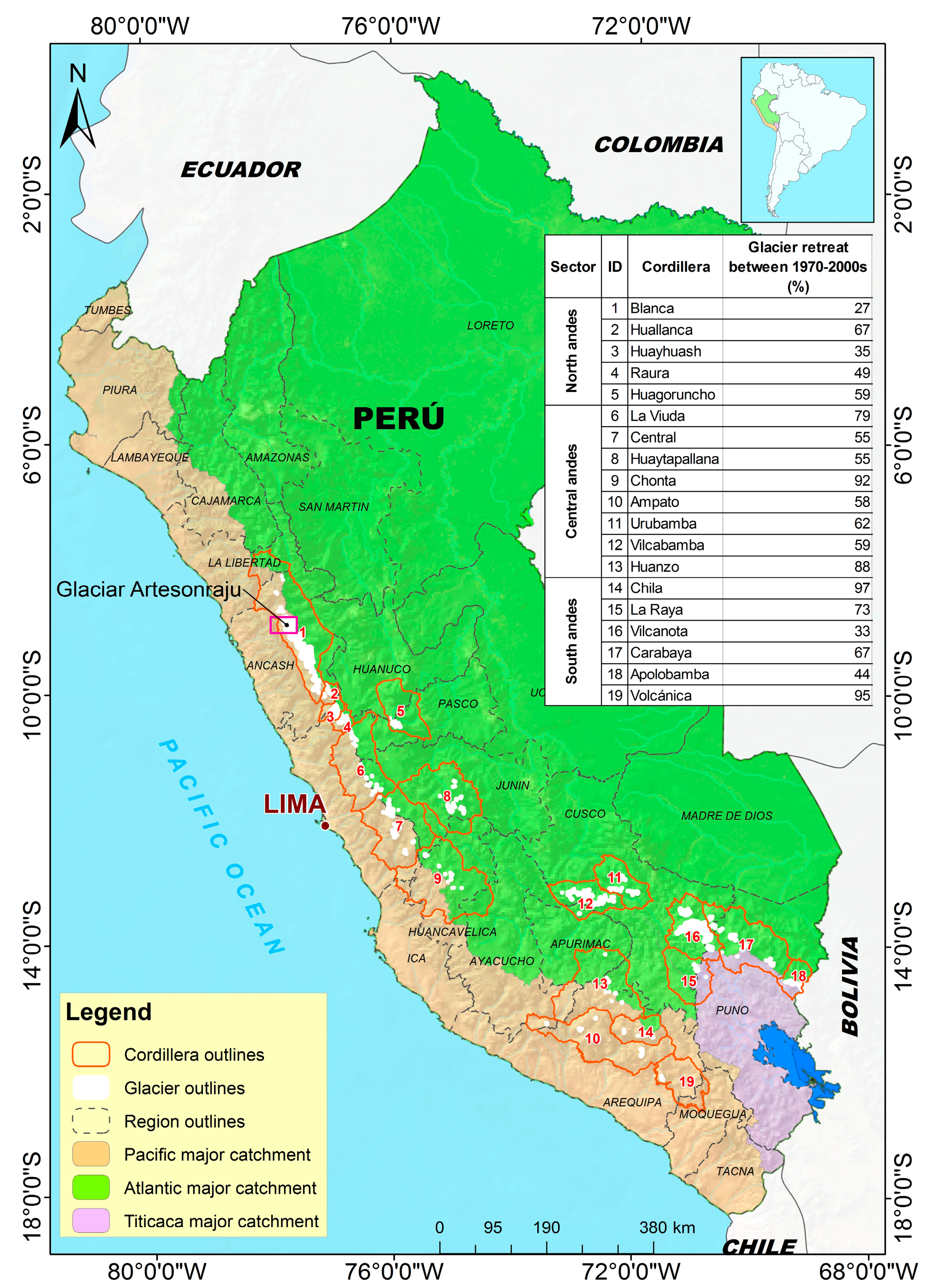
2. Region under Study
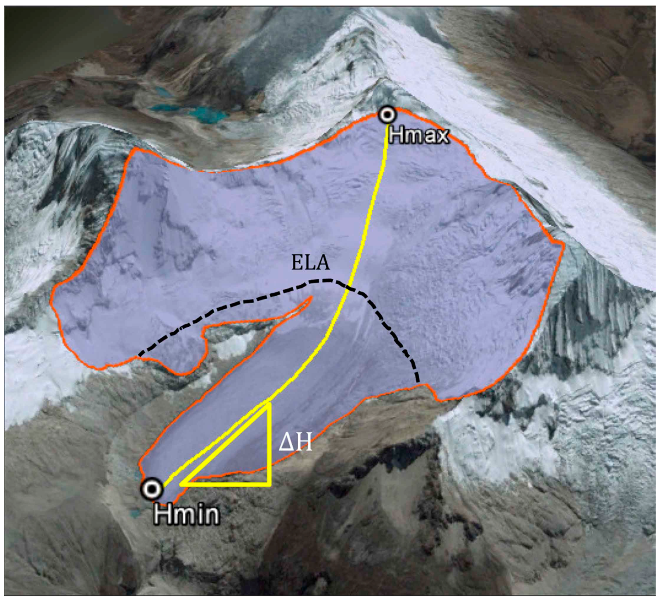
3. Materials and Methods
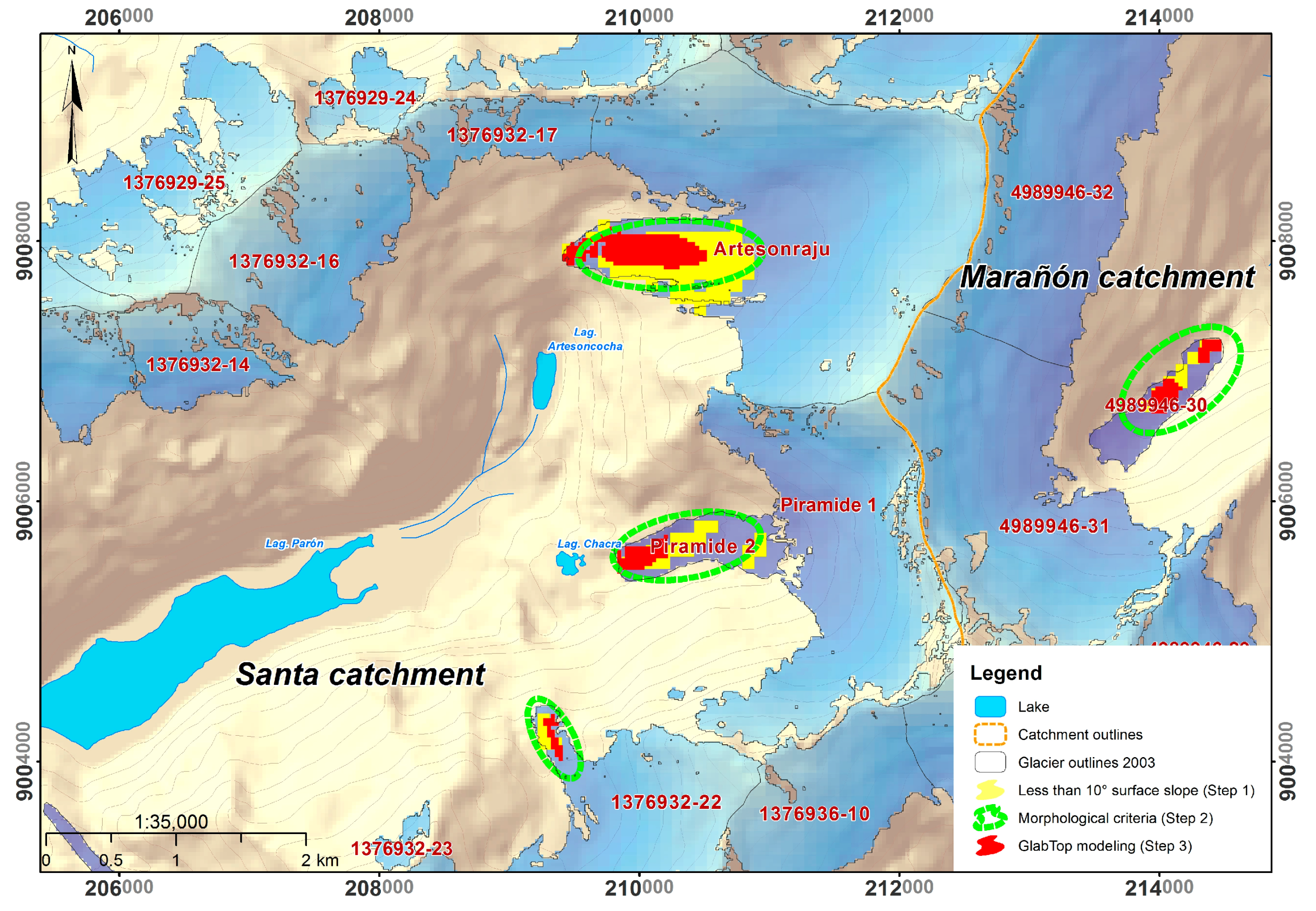
- (1)
- All glacier areas with surface slopes <10° were mapped from the DEM as a pre-selection of sites with potential bed overdeepenings;
- (2)
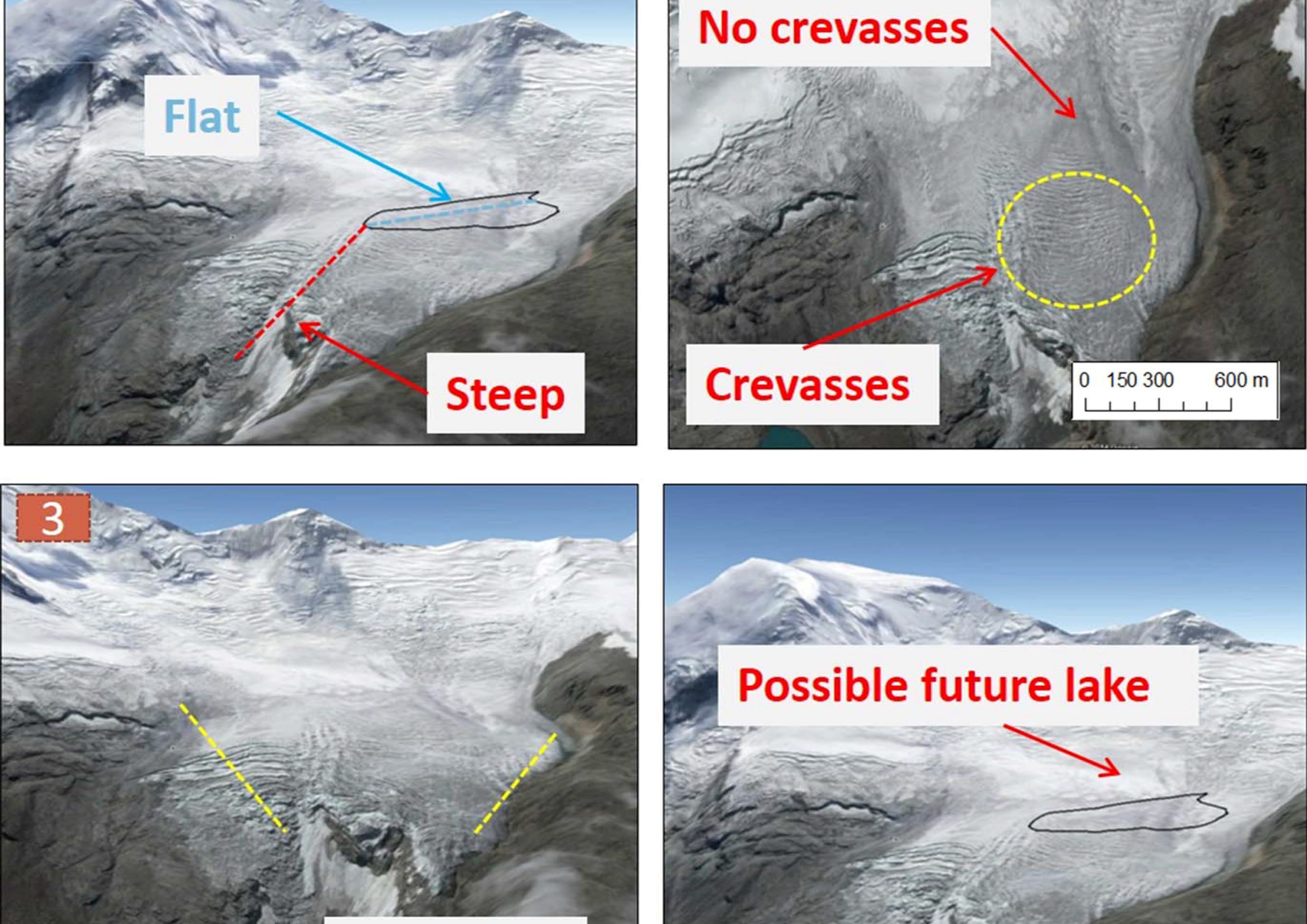
- Three morphological criteria concerning glacier surfaces (increasing slope in flow direction, onset of crevasse formation at the down-flow end of crevasse-free areas and lateral narrowing in the flow direction; Figure 3) were used in a visual interpretation based on high-resolution imagery as available in Google Earth; and
- (3)
| Number of MC fulfilled | Attributed probability/confidence level |
| 1 | low |
| 2 | medium |
| 3 | high |
- (1)
- lake formation already underway or imminent (within the coming about 10 years);
- (2)
- lake formation likely during the first half of the century (within about 10–40 years); and
- (3)
- lake formation probable around mid-century or later (after 40 years or more).
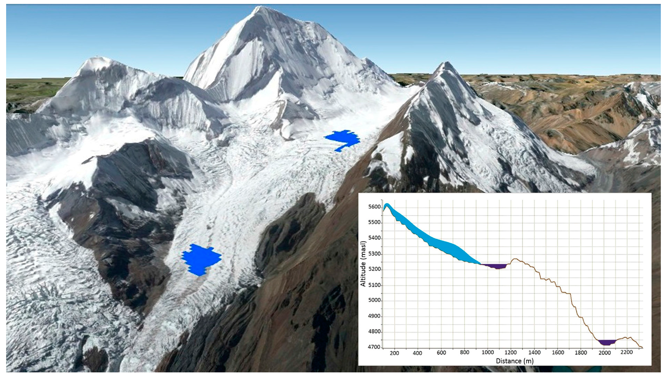
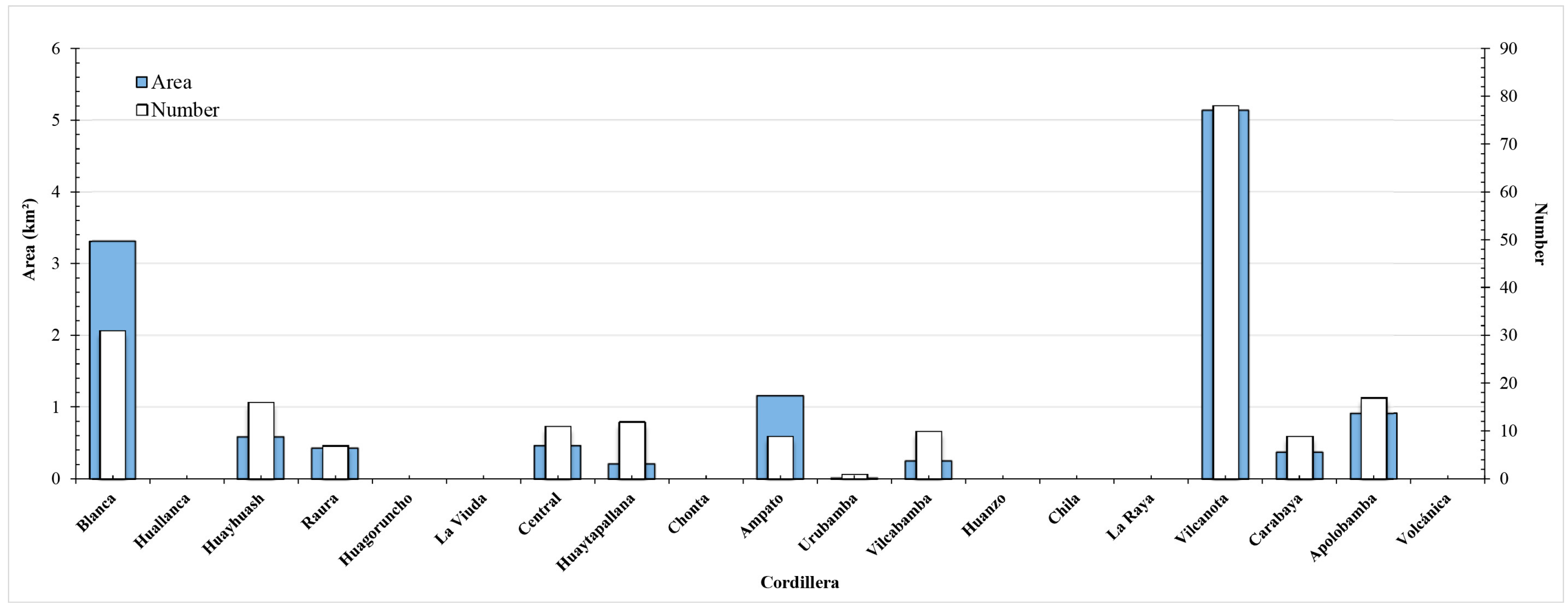
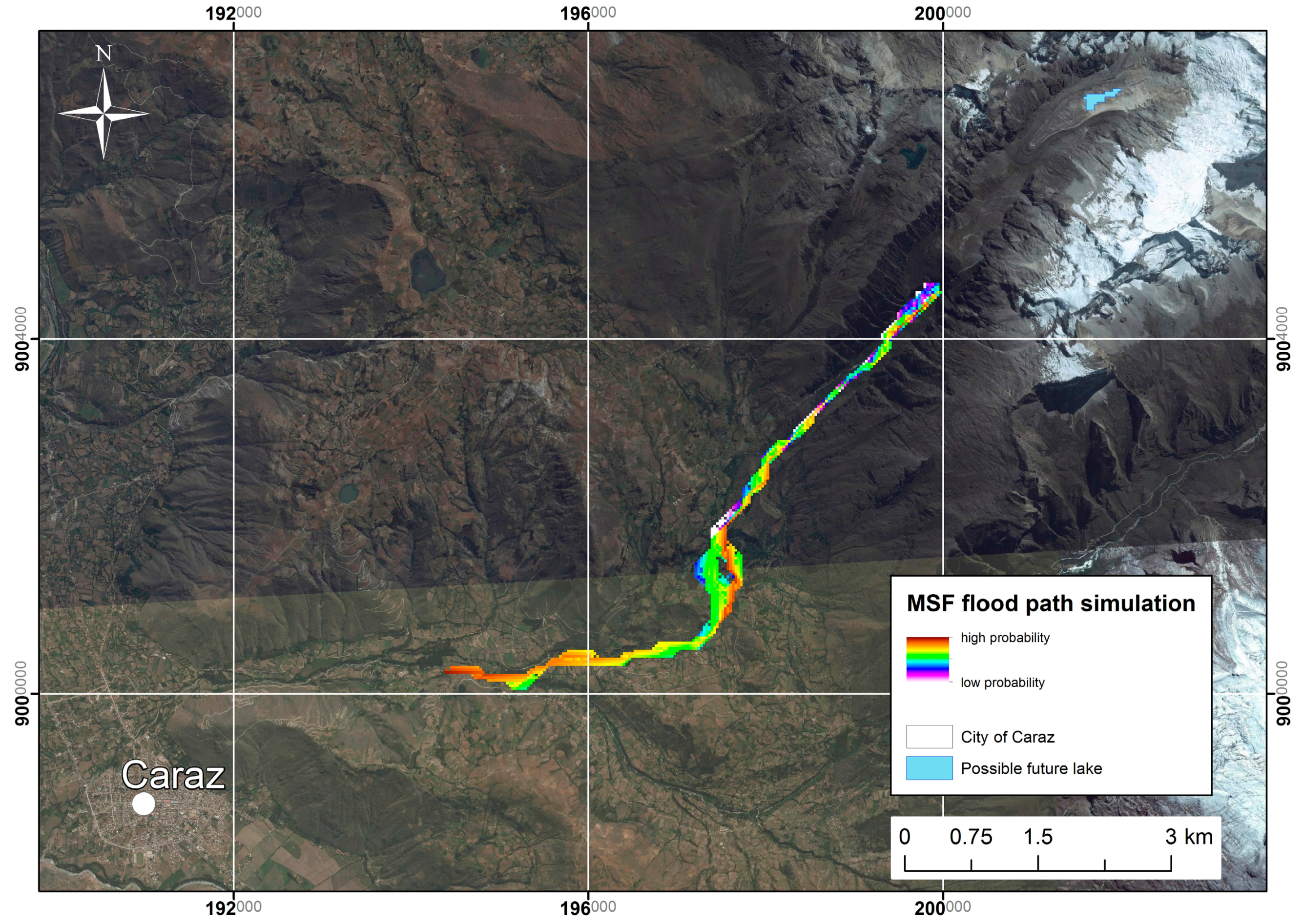
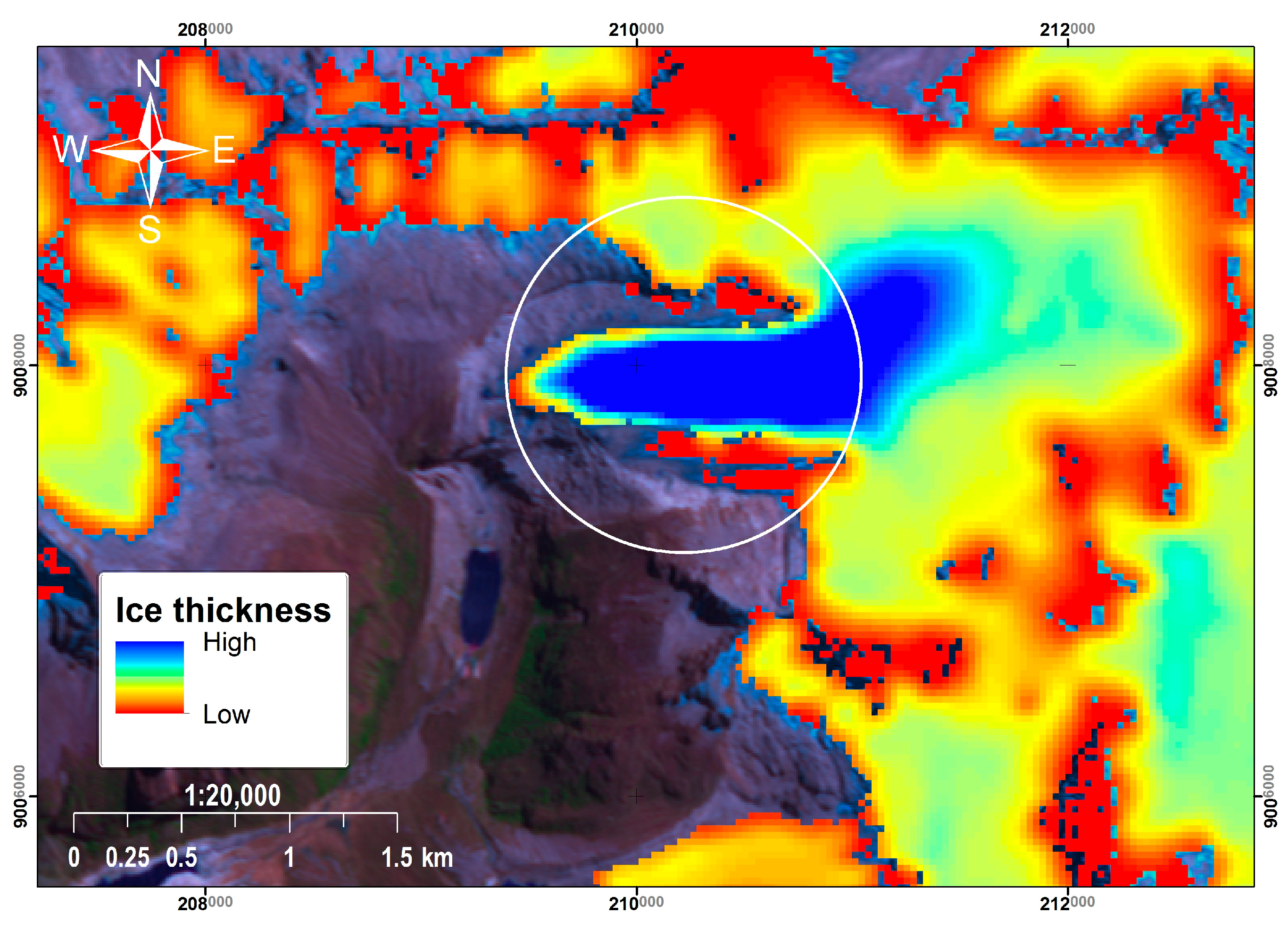
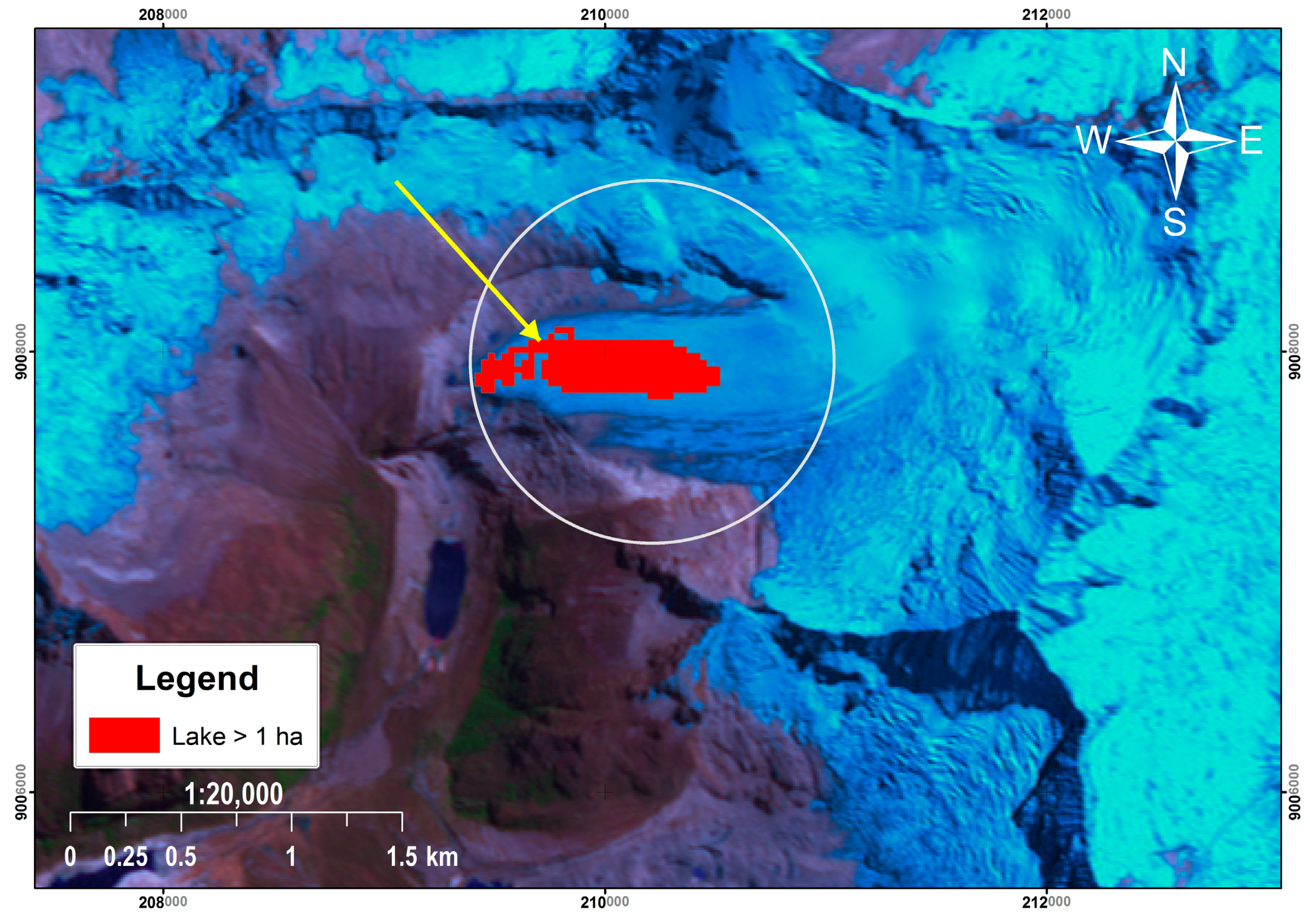
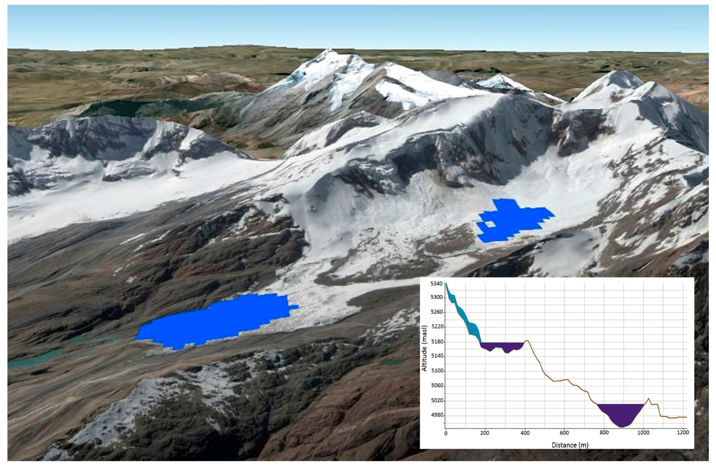
4. First Results
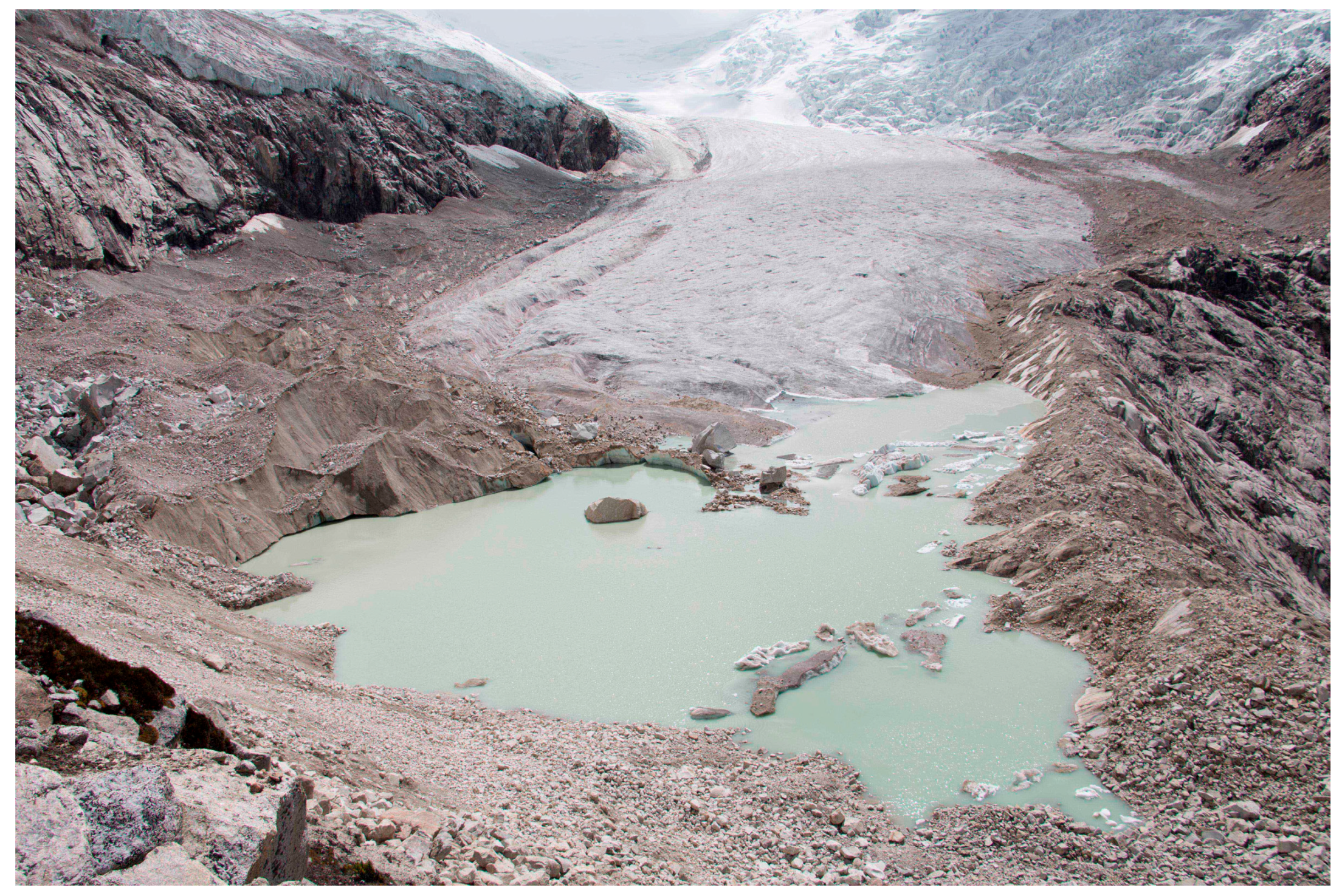
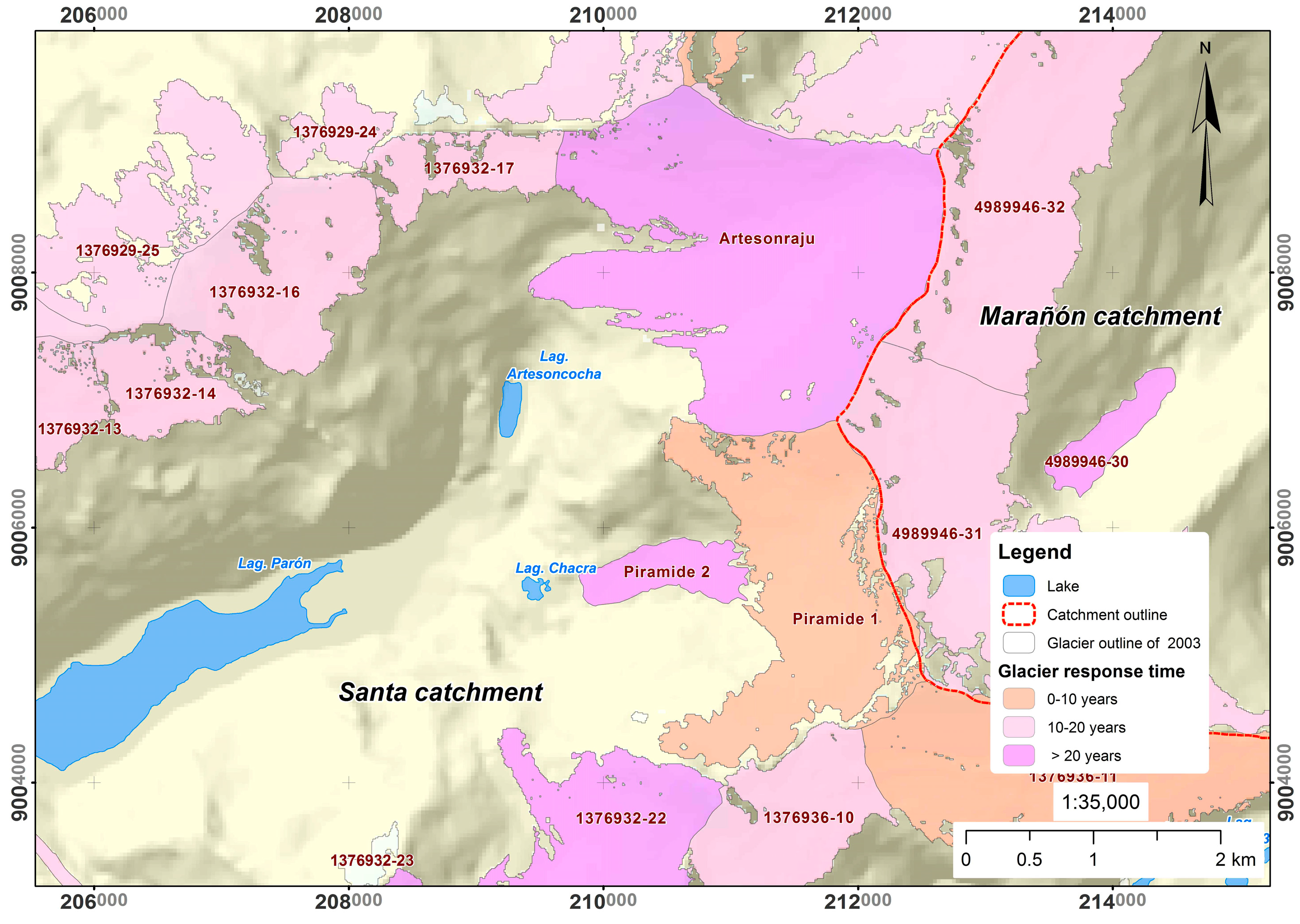
4.1. Future Lakes and Related Process Dynamics
4.2. Perspectives and Possible Improvements
5. Discussion
6. Conclusions
- The combination of GIS-based terrain analysis, visual inspection of glacier morphologies, and distributed numerical modelling of glacier-bed topographies is optimal for reaching realistic assessments including definition of probability/confidence levels.
- The most robust predictions concern the location and approximate area of glacier-bed overdeepenings; estimated morphometries relating to their exact shape, depth or volume are less certain, providing orders of magnitude rather than clearly defined values.
- Additional uncertainties relate to lake formation and lake geometries in such overdeepened parts of glacier beds becoming exposed by ice retreat. Such uncertainties especially concern the possible existence of deep/narrow breaches or gorges in the damming material (bedrock or moraine), the permeability of glacier beds or the rapid infilling of sediments.
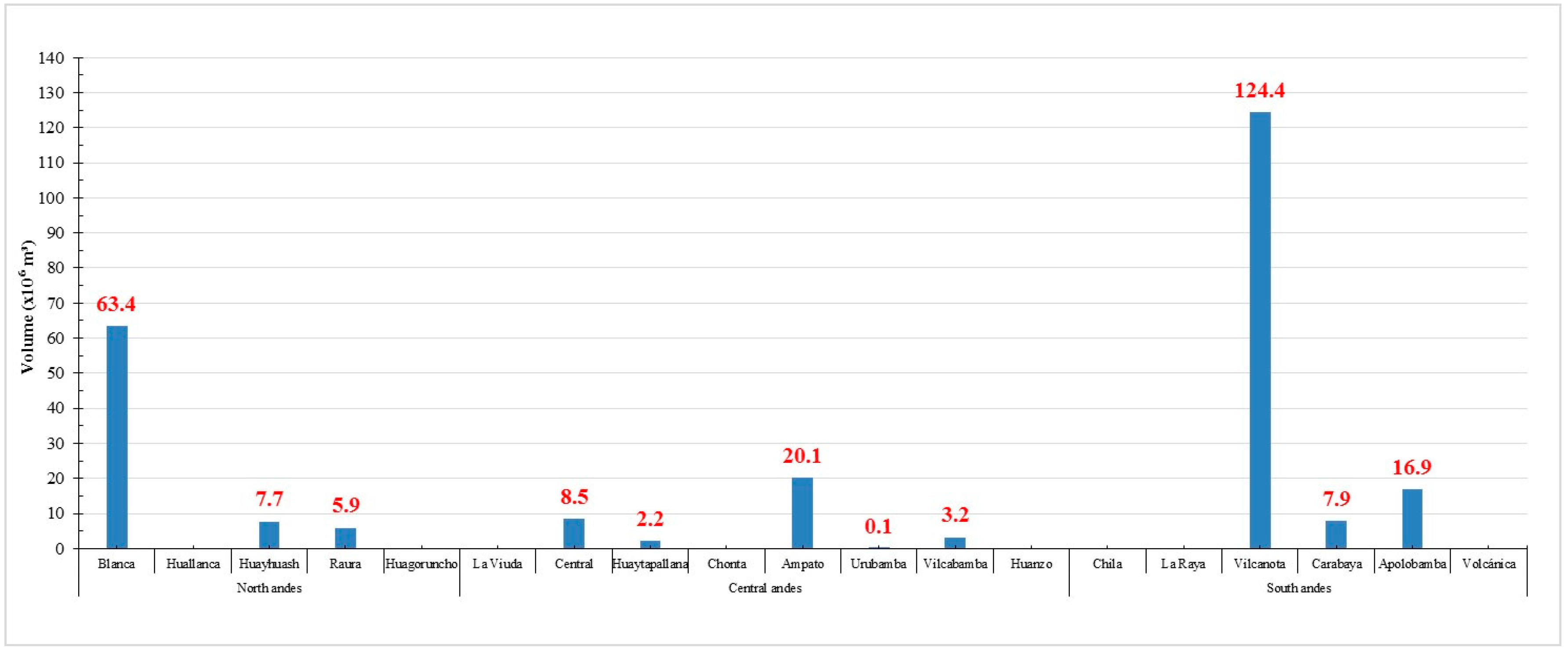
- The volume of 260 million m3 in 201 modelled bed overdeepenings represents only 0.5 to 1% of the presently still existing glacier volume; this small ratio results from the fact that most flat glacier parts have already disappeared in the investigated mountains leaving mostly small and steeply inclined glaciers.
- With further glacier shrinking and even vanishing, the rate of lake formation can be expected to be on the decline; most of the anticipated future lakes are likely to come into existence within the next few decades.
Acknowledgments
Author Contributions
Conflicts of Interest
References
- Zemp, M.; Frey, H.; Gärtner-Roer, I.; Nussbaumer, S.U.; Hoelzle, M.; Paul, F.; Haeberli, W.; Denzinger, F.; Ahlstrøm, A.P.; Anderson, B.; et al. Historically unprecedented global glacier changes in the early 21st century. J. Glaciol. 2015, 61, 1–17. [Google Scholar] [CrossRef]
- Haeberli, W.; Bütler, M.; Huggel, C.; Lehmann, T.; Schaub, Y.; Schleiss, A. New lakes in deglaciating high-mountain regions—Opportunities and risks. Clim. Chang. 2016, 139, 201–214. [Google Scholar] [CrossRef]
- Haeberli, W.; Schaub, Y.; Huggel, C. Increasing risks related to landslides from degrading permafrost into new lakes in de-glaciating mountain ranges. Geomorphology 2016. [Google Scholar] [CrossRef]
- Salzmann, N.; Kääb, A.; Huggel, C.; Allgöwer, B.; Haeberli, W. Assessment of the hazard potential of ice avalanches using remote sensing and GIS-modelling. Nor. Geogr. Tidsskr. 2004, 58, 74–84. [Google Scholar] [CrossRef]
- Linsbauer, A.; Paul, F.; Haeberli, W. Modeling glacier thickness distribution and bed topography over entire mountain ranges with GlabTop: Application of a fast and robust approach. J. Geophys. Res. 2012, 117, F03007. [Google Scholar] [CrossRef]
- Clarke, G.; Anslow, F.; Jarosch, A.; Radic, V.; Menounos, B.; Bolch, T.; Berthier, E. Ice volume and subglacial topography for western Canadian glaciers from mass balance fields, thinning rates, and a bed stress model. J. Clim. 2013, 26, 4282–4303. [Google Scholar] [CrossRef]
- Huss, M.; Farinotti, D. Distributed ice thickness and volume of all glaciers around the globe. J. Geophys. Res. 2012, 117, F04010. [Google Scholar] [CrossRef]
- Cook, S.J.; Swift, D.A. Subglacial basins: Their origin and importance in glacial systems and landscapes. Earth Sci. Rev. 2012, 115, 332–372. [Google Scholar] [CrossRef]
- Haeberli, W.; Linsbauer, A.; Cochachin, A.; Salazar, C.; Fischer, U.H. On the morphological characteristics of overdeepenings in high-mountain glacier beds. Earth Surf. Process. Landf. 2016, 41, 1980–1990. [Google Scholar] [CrossRef]
- Morlighem, M.; Rignot, E.; Mouginot, J.; Wu, X.; Seroussi, H.; Larour, E.; Paden, J. High-resolution bed topography mapping of Russell Glacier, Greenland, inferred from Operation IceBridge data. J. Glaciol. 2013, 59, 1015–1023. [Google Scholar] [CrossRef]
- Patton, H.; Swift, D.A.; Clark, C.D.; Livingstone, S.J.; Cook, S.J. Distribution and characteristics of overdeepenings beneath the Greenland and Antarctic ice sheets: Implications for overdeepening origin and evolution. Quat. Sci. Rev. 2016, 148, 128–145. [Google Scholar] [CrossRef]
- Patton, H.; Swift, D.A.; Clark, C.D.; Livingstone, S.J.; Cook, S.J.; Hubbard, A. Automated mapping of glacial overdeepenings beneath contemporary ice sheets: Approaches and potential applications. Geomorphology 2015, 232, 209–223. [Google Scholar] [CrossRef]
- Frey, H.; Haeberli, W.; Linsbauer, A.; Huggel, C.; Paul, F. A multi level strategy for anticipating future glacier lake formation and associated hazard potentials. Nat. Hazards Earth Syst. Sci. 2010, 10, 339–352. [Google Scholar] [CrossRef]
- Linsbauer, A.; Frey, H.; Haeberli, W.; Machguth, H.; Azam, M.F.; Allen, S. Modelling glacier-bed overdeepenings and possible future lakes for the glacier areas in the Himalaya-Karakoram region. Ann. Glaciol. 2016, 57, 119–130. [Google Scholar] [CrossRef]
- UGRH. Inventario. de Glaciares. del Perú, 1st ed.; Autoridad Nacional del Agua: Lima, Perú, 2014; p. 56. [Google Scholar]
- Carey, M. Shadow of Melting Glaciers. Climate Change and Andean Society; Oxford University Press: Oxford, UK, 2010; p. 240. [Google Scholar]
- Carey, M.; Huggel, C.; Bury, J.; Portocarrero, C.; Haeberli, W. An integrated socio-environmental framework for glacier hazard management and climate change adaptation: Lessons from Lake 513, Cordillera Blanca, Peru. Clim. Chang. 2012, 112, 733–767. [Google Scholar] [CrossRef]
- Intergovernmental Panel of Climate Change (IPCC). Climate Change 2013: The Physical Science Basis. Contribution of Working Group I to the Fifth Assessment Report of the Intergovernmental Panel on Climate Change; Cambridge University Press: Cambridge, UK; New York, NY, USA, 2013. [Google Scholar]
- Colonia, D.; Torres, J.; Haeberli, W.; Schauwecker, S. Metodología Para la Identificación de Posibles Lagunas Glaciares Futuras en Zonas Tropicales: Andes del Perú. Boletín N° 2; Instituto Nacional de Investigación en Glaciares y Ecosistemas de Montaña (INAIGEM), Ministerio del Ambiente (MINAM): Huaraz, Peru, 2016; pp. 37–46.
- Rabatel, A.; Francou, B.; Soruco, A.; Gomez, J.; Cáceres, B.; Ceballos, J.-L.; Basantes, R.; Vuille, M.; Sicart, J.-E.; Huggel, C.; et al. Current state of glaciers in the tropical Andes: A multi-century perspective on glacier evolution and climate change. Cryosphere 2013, 7, 81–102. [Google Scholar] [CrossRef]
- Kaser, G.; Osmaston, H. Tropical Glaciers; Cambridge University Press: New York, NY, USA, 2002. [Google Scholar]
- Salzmann, N.; Huggel, C.; Rohrer, M.; Silverio, W.; Mark, B.G.; Burns, P.; Portocarrero, C. Glacier changes and climate trends derived from multiple sources in the data scarce Cordillera Vilcanota region, southern Peruvian Andes. Cryosphere 2013, 7, 103–118. [Google Scholar] [CrossRef]
- Hanshaw, M.N.; Bookhagen, B. Glacial areas, lake areas, and snow lines from 1975 to 2012: Status of the Cordillera Vilcanota, including the Quelccaya Ice Cap, northern central Andes, Peru. Cryosphere 2014, 8, 359–376. [Google Scholar] [CrossRef]
- Schauwecker, S.; Rohrer, M.; Acuña, D.; Cochachin, A.; Dávila, L.; Frey, H.; Giráldez, C.; Gómez, J.; Huggel, C.; Jacques-Coper, M.; et al. Climate trends and glacier retreat in the Cordillera Blanca, Peru, revisited. Glob. Planet. Chang. 2014, 119, 85–97. [Google Scholar] [CrossRef]
- Cochachin, A.; Haeberli, W. Cambio climático y glaciares-Glaciers and climate change. In Perú: País de Montaña–los Desafíos Frente al Cambio Climático (Peru: Mountain Country–Facing the Challenges of Climate Change); Lima COP20/CMP10; Ministerio del Ambiente (MINAM): Lima, Peru, 2014; pp. 53–55. [Google Scholar]
- Emmer, A.; Klimeš, J.; Mergili, M.; Vilímek, V.; Cochachin, A. 882 Lakes of the Cordillera Blanca: An inventory, classification, evolution and assessment of susceptibility to outburst floods. Catena 2016, 147, 269–279. [Google Scholar] [CrossRef]
- Portocarrero, C.A. The Glacial Lake Handbook: Reducing Risk from Dangerous Glacial Lakes in the Cordillera Blanca, Peru; Technical Report; United States Agency for International Development; Global Climate Change Office; Climate Change Resilient Development Project: Washington, DC, USA, 2014.
- Linsbauer, A.; Paul, F.; Hoelzle, M.; Frey, H.; Haeberli, W. The Swiss Alps without glaciers—A GIS-based modelling approach for reconstruction of glacier beds. In Proceedings of the Geomorphometry 2009, Zurich, Switzerland, 31 August–2 September 2009; pp. 243–247. [Google Scholar]
- Haeberli, W.; Hoelzle, M. Application of inventory data for estimating characteristics of and regional climate-change effects on mountain glaciers: A pilot study with the European Alps. Ann. Glaciol. 1995, 21, 206–212. [Google Scholar] [CrossRef]
- Farinotti, D.; Brinkerhoff, D.J.; Clarke, G.K.C.; Fürst, J.J.; Frey, H.; Gantayat, P.; Gillet-Chaulet, F.; Girard, C.; Huss, M.; Leclercq, P.W.; et al. How accurate are estimates of glacier ice thickness? Results from ITMIX, the Ice Thickness Models Intercomparison eXperiment. Cryosphere Discuss. 2017, 11, 949–970. [Google Scholar] [CrossRef]
- Paul, F.; Linsbauer, A. Modeling of glacier bed topography from glacier outlines, central branch lines, and a DEM. Int. J. Geogr. Inf. Sci. 2012, 26, 1173–1190. [Google Scholar] [CrossRef]
- Chisolm, R.E. Climate Change Impacts and Water Security in the Cordillera Blanca, Peru. Ph.D. Thesis, University of Texas at Austin, Austion, TX, USA, 2016. [Google Scholar]
- Zemp, M.; Kääb, A.; Hoelzle, M.; Haeberli, W. GIS-based modelling of the glacial sediment balance. Z. für Geomorphol. 2005, 138, 113–129. [Google Scholar]
- Haeberli, W.; Fisch, W. Electrical resistivity soundings of glacier beds: A test study on Grubengletscher, Wallis, Swiss Alps. J. Glaciol. 1984, 30, 373–376. [Google Scholar] [CrossRef]
- Linsbauer, A.; Frank, P.; Machguth, H.; Haeberli, W. Comparing three different methods to model scenarios of future glacier change in the Swiss Alps. Ann. Glaciol. 2013, 54, 241–253. [Google Scholar] [CrossRef]
- Jóhannesson, T.; Raymond, C.; Waddington, E. Time-scale for adjustment of glaciers to changes in mass balance. J. Glaciol. 1989, 35, 355–369. [Google Scholar]
- Braithwaite, R.J.; Müller, F. On the parameterization of glacier equilibrium line altitude. In Riederalp Workshop 1978-World Glacier Inventory; IAHS Publication: Washington, DC, USA, 1980; pp. 263–271. [Google Scholar]
- Braithwaite, R.J.; Raper, S.C.B. Estimating equilibrium-line altitude (ELA) from glacier inventory data. Ann. Glaciol. 2009, 50, 127–132. [Google Scholar] [CrossRef]
- Machguth, H.; Haeberli, W.; Paul, F. Mass-balance parameters derived from a synthetic network of mass-balance glaciers. J. Glaciol. 2012, 58, 965–979. [Google Scholar] [CrossRef]
- Torres, J.; Colonia, D.; Haeberli, W.; Giráldez, C.; Frey, H.; Huggel, C. Thicknesses and volumes of glaciers in the Andes of Peru estimated with satellite data and digital terrain information. Geophys. Res. Abstr. 2014, 16, EGU2014-13759. [Google Scholar]
- Huggel, C.; Kääb, A.; Haeberli, W.; Krummenacher, B. Regional-scale GIS-models for assessment of hazards from glacier lake outbursts: Evaluation and application in the Swiss Alps. Nat. Hazards Earth Syst. Sci. 2003, 3, 647–662. [Google Scholar] [CrossRef]
- Huggel, C.; Haeberli, W.; Kääb, A.; Bieri, D.; Richardson, S. An assessment procedure for glacial hazards in the Swiss Alps. Can. Geotech. J. 2004, 41, 1068–1083. [Google Scholar] [CrossRef]
- Allen, S.K.; Linsbauer, A.; Randhawa, S.S.; Huggel, C.; Rana, P.; Kumari, A. Glacial lake outburst flood risk in Himachal Pradesh, India: An integrative and anticipatory approach considering current and future threats. Nat. Hazards 2016, 84, 1741–1763. [Google Scholar] [CrossRef]
- Maanya, U.S.; Kulkarni, A.V.; Tiwari, A.; Bhar, E.D.; Srinivasan, J. Identification of potential glacial lake sites and mapping maximum extent of existing glacier lakes in Drang Drung and Samudra Tapu glaciers, Indian Himalaya. Curr. Sci. 2016, 111, 553–560. [Google Scholar] [CrossRef]
- Schneider, D.; Huggel, C.; Cochachin, A.; Guillén, S.; García, J. Mapping hazards from glacier lake outburst floods based on modelling of process cascades at Lake 513, Carhuaz, Peru. Adv. Geosci. 2014, 35, 145–155. [Google Scholar] [CrossRef]
- Worni, R.; Huggel, C.; Clague, J.J.; Schaub, Y.; Stoffel, M. Coupling glacial lake impact, dam breach, and flood processes: A modeling perspective. Geomorphology 2014, 224, 161–176. [Google Scholar] [CrossRef]
- Schaub, Y.; Huggel, C.; Cochaching, A. Ice-avalanche scenario elaboration and uncertainty propagation in numerical simulation of rock-/ice-avalanche-induced impact waves at Mount Hualcán and Lake 513, Peru. Landslides 2016, 13, 1445–1459. [Google Scholar] [CrossRef]
- Somos-Valenzuela, M.A.; Chisolm, R.E.; Rivas, D.S.; Portocarrero, C.; McKinney, D.C. Modeling glacial lake outburst flood process chain: The case of Lake Palcacocha and Huaraz, Peru. Hydrol. Earth Syst. Sci. 2016, 20, 2519–2543. [Google Scholar] [CrossRef]


| Andes | Catchment | Number |
|---|---|---|
| North | Santa | 23 |
| Marañón | 24 | |
| Pativilca | 5 | |
| Huallaga | 2 | |
| Central | Mantaro | 12 |
| Rímac | 4 | |
| Mala | 1 | |
| Perené | 3 | |
| Cañete | 3 | |
| Ocoña | 8 | |
| Camaná | 1 | |
| Alto Apurímac | 6 | |
| Central and South | Urubamba | 67 |
| South | Alto Madre de Dios | 1 |
| Inambari | 29 | |
| Azángaro | 5 | |
| Suches | 7 | |
| Total | 201 |
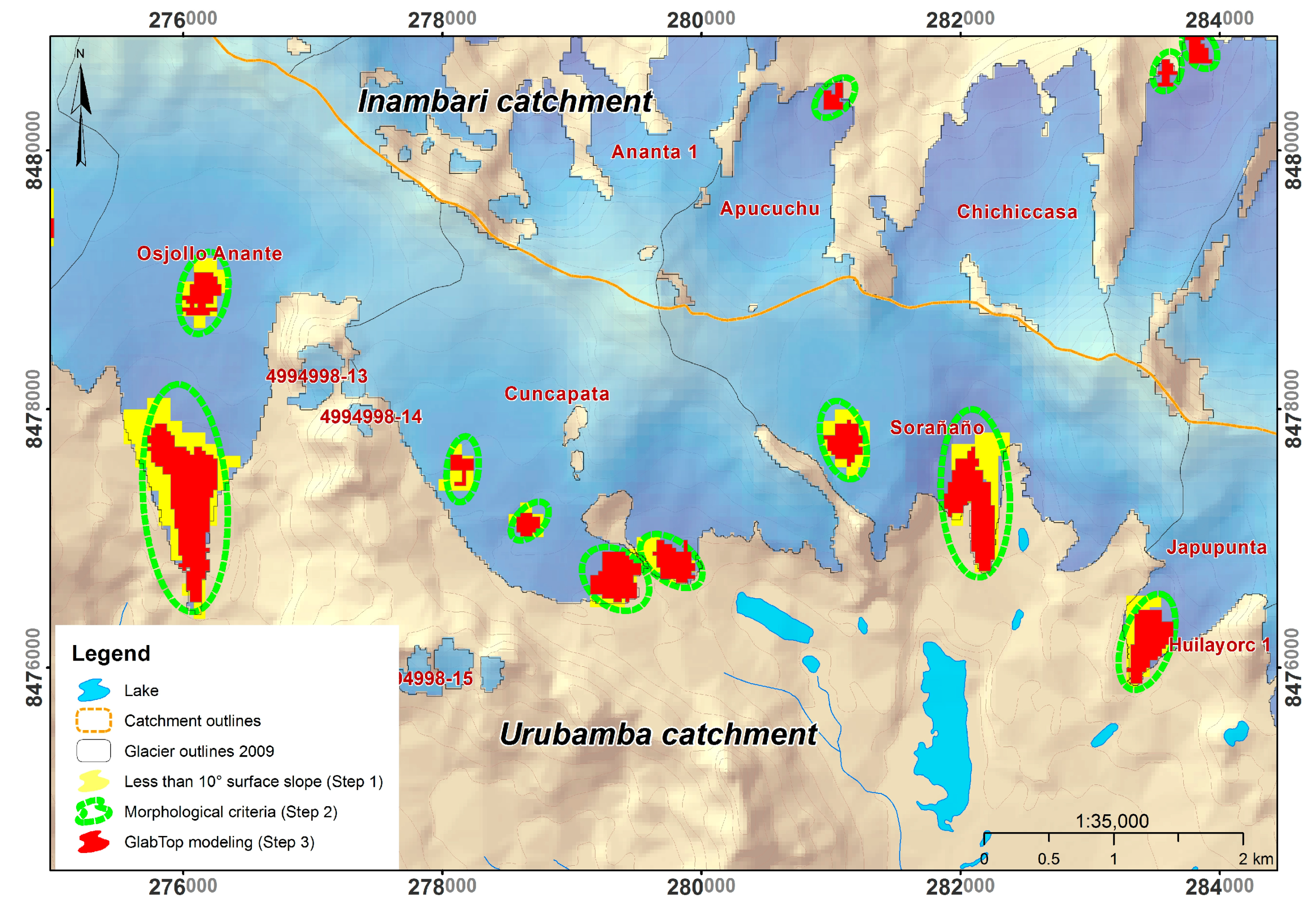
| No. | Future Lake | Volume (×10⁶ m³) | Name | Glacier Code | Catchment | Subbasin | Microbasin |
|---|---|---|---|---|---|---|---|
| 1 | LF31-CB | 24.3792 | Jankapampa 1 | 4989944-13 | Marañón | Yanamayo | Pomabamba |
| 2 | LF21-CVN | 18.792 | Osjollo Ananta | 4994899-13 | Urubamba | Yavero | Tinquimayo |
| 3 | LF22-CVN | 13.4055 | Osjollo Ananta | 4994899-13 | Urubamba | Yavero | Tinquimayo |
| 4 | LF51-CVN | 12.6522 | Osjollo Anante | 4994998-12 | Urubamba | Vilcanota | Salcca |
| 5 | LF45-CVN | 11.1456 | 4994978-15 | Urubamba | Vilcanota | Pitumarca | |
| 6 | LF12-CAP | 5.5962 | 4664898-10 | Inambari | Huari Huari | Sina | |
| 7 | LF26-CB | 5.3982 | 4989967-4 | Marañón | Puchca | Mosna | |
| 8 | LF56-CVN | 5.3676 | Sorañaño | 4994999-2 | Urubamba | Vilcanota | Salcca |
| 9 | LF5-CAM | 5.2398 | Coropuna | 1364499-1 | Ocoña | Chichas | Collpa Huayco |
| 10 | LF5-CVN | 4.7115 | Jollepunco | 4994897-4 | Urubamba | Yavero | Tinquimayo |
| 11 | LF4-CAM | 4.5981 | Coropuna | 1364499-1 | Ocoña | Chichas | Collpa Huayco |
| 12 | LF4-CB | 4.4505 | Artesonraju | 1376932-18 | Santa | Llullán | Parón |
| Classification | Number |
|---|---|
| Underway or imminent | 133 |
| First half of the century | 43 |
| Mid-century or later | 25 |
| Total | 201 |
© 2017 by the authors. Licensee MDPI, Basel, Switzerland. This article is an open access article distributed under the terms and conditions of the Creative Commons Attribution (CC BY) license (http://creativecommons.org/licenses/by/4.0/).
Share and Cite
Colonia, D.; Torres, J.; Haeberli, W.; Schauwecker, S.; Braendle, E.; Giraldez, C.; Cochachin, A. Compiling an Inventory of Glacier-Bed Overdeepenings and Potential New Lakes in De-Glaciating Areas of the Peruvian Andes: Approach, First Results, and Perspectives for Adaptation to Climate Change. Water 2017, 9, 336. https://doi.org/10.3390/w9050336
Colonia D, Torres J, Haeberli W, Schauwecker S, Braendle E, Giraldez C, Cochachin A. Compiling an Inventory of Glacier-Bed Overdeepenings and Potential New Lakes in De-Glaciating Areas of the Peruvian Andes: Approach, First Results, and Perspectives for Adaptation to Climate Change. Water. 2017; 9(5):336. https://doi.org/10.3390/w9050336
Chicago/Turabian StyleColonia, Daniel, Judith Torres, Wilfried Haeberli, Simone Schauwecker, Eliane Braendle, Claudia Giraldez, and Alejo Cochachin. 2017. "Compiling an Inventory of Glacier-Bed Overdeepenings and Potential New Lakes in De-Glaciating Areas of the Peruvian Andes: Approach, First Results, and Perspectives for Adaptation to Climate Change" Water 9, no. 5: 336. https://doi.org/10.3390/w9050336