A Review of Ocean/Sea Subsurface Water Temperature Studies from Remote Sensing and Non-Remote Sensing Methods


 and
and
Abstract
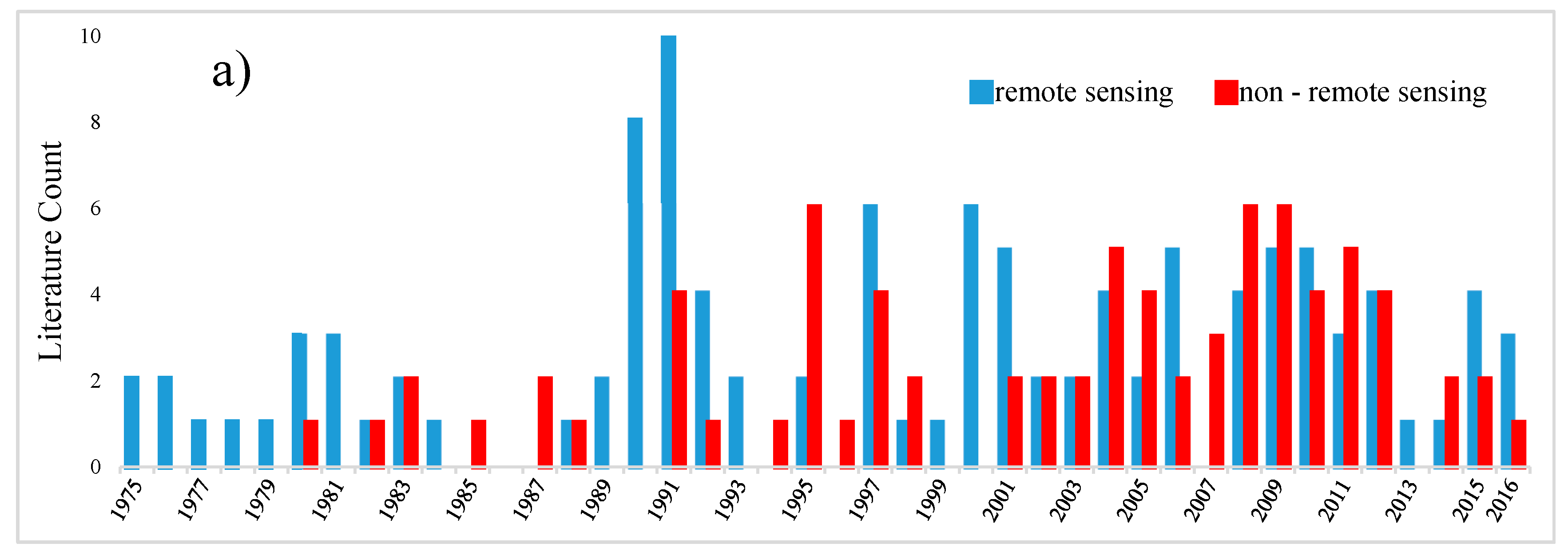
:1. Introduction
2. Vertical and Horizontal Ocean/Sea Subsurface Water Temperature Anomalies
3. Impacts of Different Dynamics on Ocean/Sea Subsurface Water Temperature Profiles
4. Remote Sensing Capabilities for Estimating Ocean/Sea Subsurface Water Temperature
5. Vertical Thermal Structure
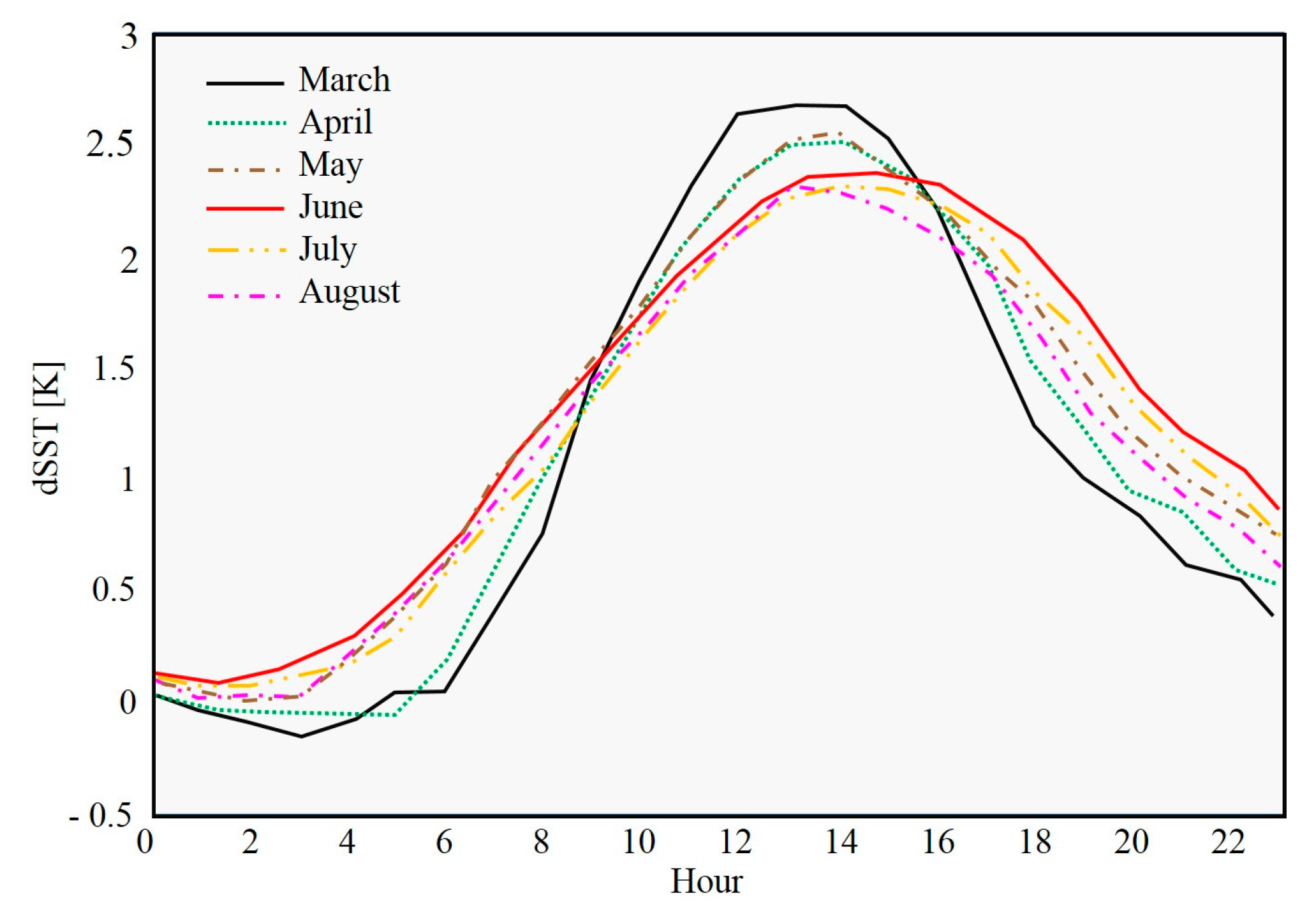
5.1. Sea Surface Temperature
5.2. Sea Surface Height
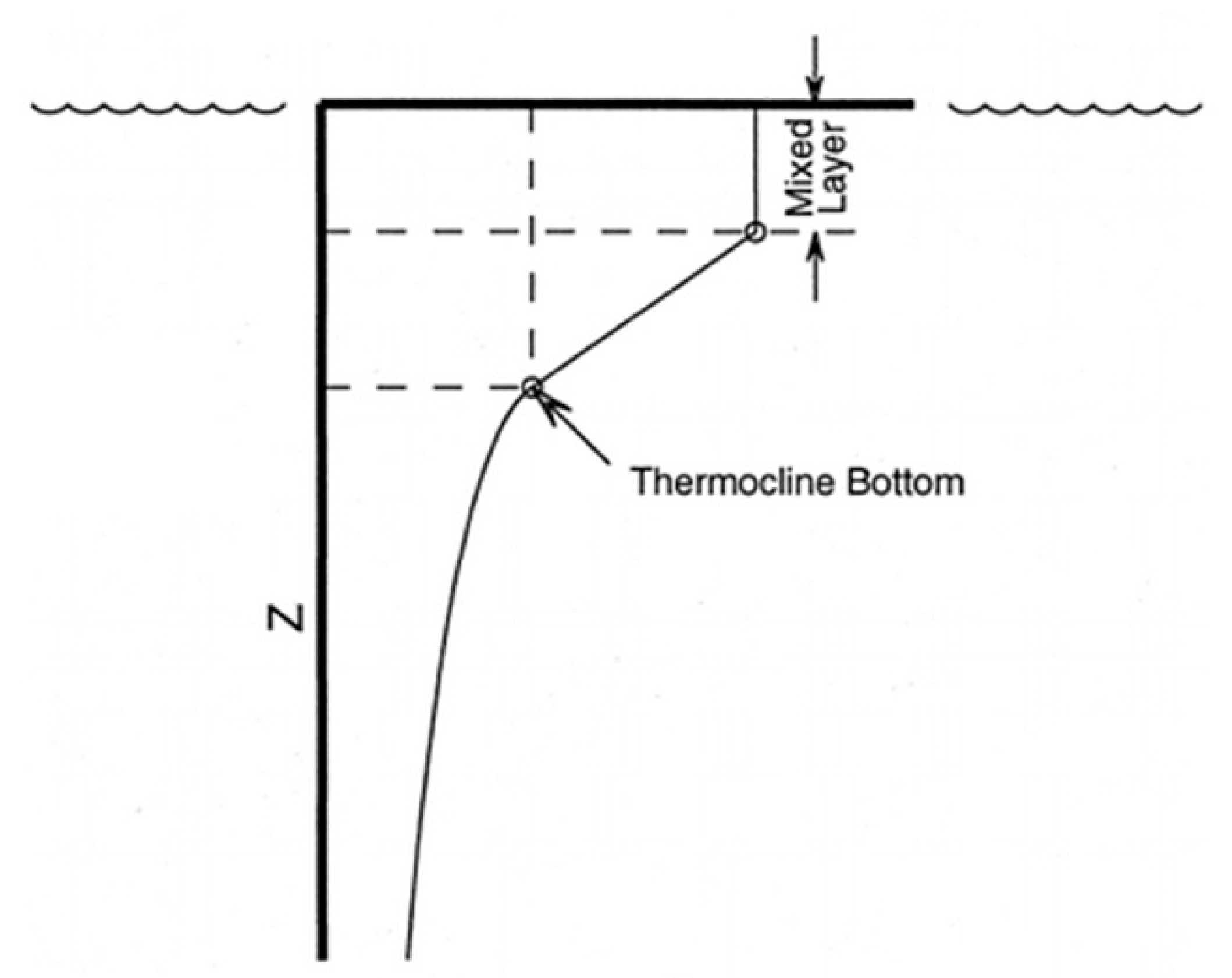
5.3. Mixed Layer Depth
5.4. Thermocline Depth
6. Limitations and Challenges
7. Accurate Sea Surface Temperature
8. Perspective
9. Conclusions
Acknowledgments
Author Contributions
Conflicts of Interest
References
- Intergovernmental Panel on Climate Change (IPCC). Climate Change 2007: The physical science basis. In Fourth Assessment Report of the Intergovernmental Panel on Climate Change Cambridge; Solomon, S., Qin, D., Manning, M., Chen, Z., Marquis, M., Averyt, K.B., Tignor, M., Miller, H.L., Eds.; Contribution of Working Group I; Cambridge University Press: Cambridge, UK, 2007. [Google Scholar]
- Mänd, P.; Hallik, L.; Peñuelas, J.; Nilson, T.; Duce, P.; Emmett, B.A.; Beier, C.; Estiarte, M.; Garadnai, J.; Kalapos, T.; et al. Responses of the reflectance indices PRI and NDVI to experimental warming and drought in European shrublands along a north–south climatic gradient. Remote Sens. Environ. 2010, 114, 626–636. [Google Scholar] [CrossRef]
- Intergovernmental Panel on Climate Change (IPCC). Summary for policymakers. In Climate Change 2013: The Physical Science Basis; Stocker, T.F., Qin, D., Plattner, G.-K., Tignor, M., Allen, S.K., Boschung, J., Midgley, P.M., Eds.; Contribution of Working Group I to the Fifth Assessment Report of the Intergovernmental Panel on Climate Change; Cambridge University Press: Cambridge, UK; New York, NY, USA, 2013. [Google Scholar]
- Nazarenko, L.; Schmidt, G.A.; Miller, R.L.; Tausnev, N.; Kelley, M.; Ruedy, R.; Russell, G.L.; Aleinov, I.; Bauer, M.; Bauer, S. Future climate change under RCP emission scenarios with GISS ModelE2. J. Adv. Model. Earth Syst. 2015, 7, 244–267. [Google Scholar] [CrossRef]
- Molua, E.L. Reappraisal of the climate change challenge in the congo basin and implications for the cost of adaptation. Environ. Nat. Resour. Res. 2015, 5, 80–97. [Google Scholar] [CrossRef]
- Buchwitz, M.; Reuter, M.; Schneising, O.; Boesch, H.; Guerlet, S.; Dils, B.; Aben, I.; Armante, R.; Bergamaschi, P.; Blumenstock, T.; et al. The Greenhouse Gas Climate Change Initiative (GHG-CCI): Comparison and quality assessment of near-surface-sensitive satellite-derived CO2 and CH4 global data sets. Remote Sens. Environ. 2015, 162, 344–362. [Google Scholar] [CrossRef]
- Ghoneim, E. A remote sensing study of some impacts of global warming on the Arab Region. In Arab Environment: Climate Change; Report by at the Center for Remote Sensing; Boston University: Boston, MA, USA, 2009; Chapter 3; pp. 31–46. [Google Scholar]
- Watts, N.; Adger, W.N.; Agnolucci, P.; Blackstock, J.; Byass, P.; Cai, W.; Chaytor, S.; Colbourn, T.; Collins, M.; Cooper, A.; et al. Health and climate change: Policy responses to protect public health. Lancet 2015, 386, 1861–1914. [Google Scholar] [CrossRef]
- Cook, B.I.; Ault, T.R.; Smerdon, J.E. Unprecedented 21st-century drought risk in the American Southwest and Central Plains. Sci. Adv. 2015, 1, e1400082. [Google Scholar] [CrossRef] [PubMed]
- Bruno, M.F.; Molfetta, M.G.; Petrillo, A.F. The influence of interannual variability of mean sea level in the Adriatic Sea on extreme values. J. Coast. Res. 2014, 70, 241–246. [Google Scholar] [CrossRef]
- Alfieri, L.; Burek, P.; Feyen, L.; Forzieri, G. Global warming increases the frequency of river floods in Europe. Hydrol. Earth Syst. Sci. 2015, 19, 2247–2260. [Google Scholar] [CrossRef] [Green Version]
- Vousdoukas, M.I.; Mentaschi, L.; Voukouvalas, E.; Verlaan, M.; Feyen, L. Extreme sea levels on the rise along Europe’s coasts. Earth’s Future 2017, 5, 304–323. [Google Scholar] [CrossRef]
- Brown, M.E.; de Beurs, K.M.; Marshall, M. Global phenological response to climate change in crop areas using satellite remote sensing of vegetation, humidity and temperature over 26 years. Remote Sens. Environ. 2012, 126, 174–183. [Google Scholar] [CrossRef]
- Asseng, S.; Ewert, F.; Martre, P.; Rötter, R.P.; Lobell, D.B.; Cammarano, D.; Kimball, B.A.; Ottman, M.J.; Wall, G.W.; White, J.W.; et al. Rising temperatures reduce global wheat production. Nat. Clim. Chang. 2015, 5, 143–147. [Google Scholar] [CrossRef]
- Coffel, E.; Horton, R. Climate change and the impact of extreme temperatures on aviation. Weather Clim. Soc. 2015, 7, 94–102. [Google Scholar] [CrossRef]
- Li, T.; Horton, R.M.; Bader, D.A.; Huang, G.; Sun, Q.; Kinney, P.L. Heat-related mortality projections for cardiovascular and respiratory disease under the changing climate in Beijing, China. Sci. Rep. 2015, 5, 11441. [Google Scholar] [CrossRef] [PubMed]
- Preston, B.L. Observed winter warming of the Chesapeake Bay Estuary (1949–2002): Implications for ecosystem management. Environ. Assess. 2004, 34, 125–139. [Google Scholar] [CrossRef] [PubMed]
- Tan, J.; Cherkauer, K.A. Assessing stream temperature variation in the Pacific Northwest using airborne thermal infrared remote sensing. J. Environ. Manag. 2013, 115, 206–216. [Google Scholar] [CrossRef] [PubMed]
- Fisher, J.I.; Mustard, J.F. High spatial resolution sea surface climatology from Landsat thermal infrared data. Remote Sens. Environ. 2004, 90, 293–307. [Google Scholar] [CrossRef]
- Johnson, G.C.; Mecking, B.; Sloyan, B.M.; Wijffels, S.E. Recent bottom water warming in the Pacific Ocean. J. Clim. 2007, 20, 5365–5375. [Google Scholar] [CrossRef]
- Johnson, G.C.; Purkey, S.G.; Bullister, J.L. Warming and freshening in the abyssal southeast Indian Ocean. J. Clim. 2008, 21, 5351–5363. [Google Scholar] [CrossRef]
- Johnson, G.C.; Purkey, S.G.; Toole, J.M. Reduced Antarctic meridional overturning circulation reaches the North Atlantic Ocean. Geophys. Res. Lett. 2008, 35, L22601. [Google Scholar] [CrossRef]
- Cazenave, A.; Nerem, R.S. Present-day sea level change: Observations and cause. Rev. Geophys. 2004, 42, RG3001. [Google Scholar] [CrossRef]
- Willis, J.K.; Roemmich, D.; Cornuelle, B. Interannual variability in upper ocean heat content, temperature and thermosteric expansion on global scales. J. Geophys. Res. 2004, 109. [Google Scholar] [CrossRef]
- Levitus, S.; Antonov, J.I.; Boyer, T.P. Warming of the world ocean, 1955–2003. Geophys. Res. Lett. 2005, 32, L02604. [Google Scholar] [CrossRef]
- Antonov, J.I.; Levitus, S.; Boyer, T.P. Thermosteric sea level rise, 1955–2003. Geophys. Res. Lett. 2005, 32, L12602. [Google Scholar] [CrossRef]
- Ishii, M.; Kimoto, M.; Sakamoto, K.; Iwasaki, S.-I. Steric sea level changes estimated from historical ocean subsurface temperature and salinity analyses. J. Oceanogr. 2006, 62, 155–170. [Google Scholar] [CrossRef]
- Song, Y.T.; Colberg, F. Deep Ocean warming assessed from altimeters, Gravity Recovery and Climate Experiment, In Situ measurements and a non-Boussinesq ocean general circulation model. J. Geophys. Res. 2011, 116, C02020. [Google Scholar] [CrossRef]
- Levitus, S.; Antonov, J.I.; Boyer, T.P.; Baranova, O.K.; Garcia, H.E.; Locarnini, R.A.; Mishonov, A.V.; Reagan, J.R.; Seidov, D.; Yarosh, E.S.; et al. World ocean heat content and thermosteric sea level change (0–2000 m), 1955–2010. Geophys. Res. Lett. 2012, 39, L10603. [Google Scholar] [CrossRef]
- Balmaseda, M.A.; Trenberth, K.E.; Källén, E. Distinctive climate signals in reanalysis of global ocean heat content. Geophys. Res. Lett. 2013, 40, 1754–1759. [Google Scholar] [CrossRef]
- Su, H.; Wu, X.; Yan, X.; Kidwell, A. Estimation of subsurface temperature anomaly in the Indian Ocean during recent global surface warming hiatus from satellite measurements: A support vector machine approach. Remote Sens. Environ. 2015, 160, 63–71. [Google Scholar] [CrossRef]
- Alavipanah, S.K.; Akbari, E.; Jeihouni, M.; Hajeb, M. A comparison between surface and subsurface temperature of water body based on remotely sensed thermal infrared data in the coastal zone. In Proceedings of the International Conference on Coastal Zones, Osaka, Japan, 16–18 May 2016; Volume 4. [Google Scholar] [CrossRef]
- Laurs, R.M.; Polovina, J.J. Satellite remote sensing: An important tool in fisheries oceanography. In Fisheries Oceanography: An Integrative Approach to Fisheries Ecology and Management; Harrison, P.J., Parsons, T.R., Eds.; Fish and Aquatic Resources Series 4; Blackwell Science: Oxford, UK, 2000; pp. 146–157. [Google Scholar]
- Polovina, J.J.; Howell, E.A. Ecosystem indicators derived from satellite remotely sensed oceanographic data for the North Pacific. ICES J. Mar. Sci. 2005, 62, 319–327. [Google Scholar] [CrossRef]
- Lee, Z.; Du, K.; Arnone, R.; Liew, S.; Penta, B. Penetration of solar radiation in the upper ocean: A numerical model for oceanic and coastal waters. J. Geophys. Res. 2005, 110, C09019. [Google Scholar] [CrossRef]
- Subsurface. Webster’s New World College Dictionary, 4th ed.; Houghton Mifflin Harcourt: Boston, MA, USA; Available online: https://www.collinsdictionary.com/dictionary/english/subsurface (accessed on 30 October 2017).
- Creatures of the Deep Sea. Layers of the Ocean. Available online: http://www.seasky.org/deep-sea/ocean-layers.html (accessed on 30 October 2017).
- Yang, J.; Gong, P.; Fu, R.; Zhang, M.H.; Chen, J.; Liang, S.; Xu, B.; Shi, J.; Dickinson, R. The role of satellite remote sensing in climate change studies. Nat. Clim. Chang. 2013, 3, 875–883. [Google Scholar] [CrossRef]
- Fiedler, P.C. Surface manifestations of subsurface thermal structure in the California Current. J. Geophys. Res. 1988, 93, 4975–4983. [Google Scholar] [CrossRef]
- Klemas, V.; Yan, X.-H. Subsurface and deeper ocean remote sensing from satellites: An overview and new results. Prog. Oceanogr. 2014, 122, 1–9. [Google Scholar] [CrossRef]
- Wu, X.; Yan, X.-H.; Jo, Y.-H.; Liu, W.T. Estimation of subsurface temperature anomaly in the North Atlantic using a self-organizing map neural network. J. Atmos. Ocean. Technol. 2012, 29, 1675–1688. [Google Scholar] [CrossRef]
- Meredith, M.P.; Garabato, A.C.; Gordon, A.L.; Johson, G.C. Evolution of the deep and bottom waters of the Scotia Sea, Southern Ocean, during 1995–2005. J. Clim. 2008, 21, 2237–3343. [Google Scholar] [CrossRef]
- Purkey, S.G.; Johnson, G.C. Warming of global abyssal and deep southern ocean waters between the 1990s and 2000s: Contributions to global heat and sea level rise. J. Clim. 2010, 23, 6336–6351. [Google Scholar] [CrossRef]
- Karagali, I.; Høyer, J.; Hasager, C. SST diurnal variability in the North Sea and the Baltic Sea. Remote Sens. Environ. 2012, 121, 159–170. [Google Scholar] [CrossRef]
- Eastwood, S.; LeBorgne, P.; Préré, S.; Poulter, D. Diurnal variability in sea surface in the Arctic. Remote Sens. Environ. 2011, 115, 2594–2602. [Google Scholar] [CrossRef]
- Kawano, T.; Doi, T.; Uchida, H.; Kouketsu, S.; Fukasawa, M.; Kawai, Y.; Katsumata, K. Heat content change in the Pacific Ocean between the 1990s and 2000s. Deep Sea Res. Part II 2010, 57, 1141–1151. [Google Scholar] [CrossRef]
- Halkides, D.; Lee, T.; Kida, S. Mechanisms controlling the seasonal mixed-layer temperature and salinity of the Indonesian seas. Ocean Dyn. 2011, 61, 481–495. [Google Scholar] [CrossRef]
- Halkides, D.J.; Waliser, D.E.; Lee, T.; Menemenlis, D.; Guan, B. Quantifying the processes controlling intraseasonal mixed-layer temperature variability in the tropical Indian Ocean. J. Geophys. Res. 2015, 120, 692–715. [Google Scholar] [CrossRef]
- Meehl, G.A.; Arblaster, J.M.; Fasullo, J.T.; Hu, A.; Trenberth, K.E. Model-based evidence of deep-ocean heat uptake during surface-temperature hiatus periods. Nat. Clim. Chang. 2011, 1, 360–364. [Google Scholar] [CrossRef]
- Ali, M.M.; Swain, D.; Weller, R.A. Estimation of ocean subsurface thermal structure from surface parameters: A neural network approach. Geophys. Res. Lett. 2004, 31, L20308. [Google Scholar] [CrossRef]
- Khedouri, E.; Szczechowski, C.; Cheney, R. Potential oceanographic applications of satellite altimetry for inferring subsurface thermal structure. In Proceedings of the OCEANS ‘83, San Francisco, CA, USA, 29 August–1 September 1983; Marine Technology Society: Washington, DC, USA, 1983; pp. 274–280. [Google Scholar]
- Yan, X.-H.; Schubel, J.R.; Pritchard, D.W. Oceanic upper mixed layer depth determination by the use of satellite data. Remote Sens. Environ. 1990, 32, 55–74. [Google Scholar] [CrossRef]
- Chu, P.C.; Fan, C.; Liu, W.T. Determination of vertical thermal structure from sea surface temperature. J. Atmos. Ocean. Technol. 2000, 17, 971–979. [Google Scholar] [CrossRef]
- Yan, X.-H.; Okubo, A.; Shubel, J.R.; Pritchard, D.W. An analytical model for remote sensing determination of the mixed layer depth. Deep Sea Res. Part A 1991, 38, 267–287. [Google Scholar] [CrossRef]
- Yan, X.-H.; Okubo, A. Three-dimensional analytical model for the mixed layer depth. J. Geophys. Res. 1992, 97, 20201–20226. [Google Scholar] [CrossRef]
- Fischer, M. Multivariate projection of ocean surface data onto subsurface sections. Geophys. Res. Lett. 2000, 27, 755–757. [Google Scholar] [CrossRef]
- Willis, J.K.; Roemmich, D.; Cornuelle, B. Combining altimetric height with broadscale profile data to estimate steric height, heat storage, subsurface temperature and sea-surface temperature variability. J. Geophys. Res. 2003, 108, 3292. [Google Scholar] [CrossRef]
- Guinehut, S.; Le Traon, P.Y.; Larnicol, G.; Philipps, S. Combining Argo and remote-sensing data to estimate the ocean three-dimensional temperature fields—A first approach based on simulated observations. J. Mar. Syst. 2004, 46, 85–98. [Google Scholar] [CrossRef]
- Swart, S.; Speich, S.; Ansorge, I.J.; Lutjeharms, J.R.E. An altimetry-based gravest empirical mode south of Africa: 1. Development and validation. J. Geophys. Res. 2010, 115, C03002. [Google Scholar] [CrossRef]
- Meijers, A.J.S.; Bindoff, N.L.; Rintoul, S.R. Estimating the four-dimensional structure of the southern ocean using satellite altimetry. J. Atmos. Ocean. Technol. 2011, 28, 548–568. [Google Scholar] [CrossRef]
- Guinehut, S.; Dhomps, A.-L.; Larnicol, G.; Le Traon, P.-Y. High resolution 3-D temperature and salinity fields derived from in situ and satellite observations. Ocean Sci. 2012, 8, 845–857. [Google Scholar] [CrossRef] [Green Version]
- Liu, L.; Peng, S.; Wang, J.; Huang, R.X. Retrieving density and velocity fields of the ocean’s interior from surface data. J. Geophys. Res. 2014, 119, 8512–8529. [Google Scholar] [CrossRef]
- Stammer, D. Steric and wind-induced changes in TOPEX/POSEIDON large-scale sea surface topography observations. J. Geophys. Res. 1997, 102, 20987–21009. [Google Scholar] [CrossRef]
- Fukumori, I.; Raghunath, R.; Fu, L.L. Nature of global large-scale sea level variability in relation to atmospheric forcing: A modeling study. J. Geophys. Res. 1998, 103, 5493–5512. [Google Scholar] [CrossRef]
- Ferry, N.; Reverdin, G.; Oschlies, A. Seasonal sea surface height variability in the North Atlantic Ocean. J. Geophys. Res. 2000, 105, 6307–6326. [Google Scholar] [CrossRef] [Green Version]
- Mayer, D.A.; Molinari, R.L.; Baringer, M.O.N.; Goni, G.J. Transition regions and their role in the relationship between sea surface height and subsurface temperature structure in the Atlantic Ocean. Geophys. Res. Lett. 2001, 28, 3943–3946. [Google Scholar] [CrossRef]
- Gilson, J.; Roemmich, D.; Cornuelle, B.; Fu, L.L. Relationship of TOPEX/Poseidon altimetric height to steric height and circulation in the North Pacific. J. Geophys. Res. 1998, 103, 27947–27965. [Google Scholar] [CrossRef]
- Ding, H.; Elmore, A.J. Spatio-temporal patterns in water surface temperature from Landsat time series data in the Chesapeake Bay, USA. Remote Sens. Environ. 2015, 168, 335–348. [Google Scholar] [CrossRef]
- Oke, P.R.; Larnicol, G.; Fujii, Y.; Smith, G.C.; Lea, D.J.; Guinehut, S.; Remy, E.; Alonso Balmaseda, M.; Rykova, T.; Surcel-Colan, D.; et al. Assessing the impact of observations on ocean forecasts and reanalyses: Part 1, Global studies. J. Oper. Oceanogr. 2015, 8, s49–s62. [Google Scholar] [CrossRef]
- Gentemann, C.L.; Minnett, P.J.; Le Borgne, P.; Merchant, C. Multi-satellite measurements of large diurnal warming events. Geophys. Res. Lett. 2008, 35, L22602. [Google Scholar] [CrossRef]
- Merchant, C.J.; Filipiak, M.J.; Le Borgne, P.; Roquet, H.; Autret, E.; Piollé, J.F.; Lavender, S. Diurnal warm-layer events in the western Mediterranean and European shelf seas. Geophys. Res. Lett. 2008, 35, L04601. [Google Scholar] [CrossRef]
- Llewellyn-Jones, D.T.; Minnett, P.J.; Saunders, R.W.; Zavody, A.M. Satellite multichannel infrared measurements of sea surface temperature of the N.E. Atlantic Ocean using AVHRR/2. Q. J. R. Meteorol. Soc. 1984, 110, 613–631. [Google Scholar] [CrossRef]
- Francois, C.; Brisson, A.; Le Borgne, P.; Marsouin, A. Definition of a radio sounding database for sea surface brightness temperature simulations Application to sea surface temperature retrieval algorithm determination. Remote Sens. Environ. 2002, 81, 309–326. [Google Scholar] [CrossRef]
- Hosoda, K.; Murakami, H.; Sakaida, F.; Kawamura, H. Algorithm and validation of sea surface temperature observation using MODIS sensors aboard terra and aqua in the Western North Pacific. J. Oceanogr. 2007, 63, 267–280. [Google Scholar] [CrossRef]
- Petrenko, B.; Ignatov, A.; Shabanov, N.; Kihai, Y. Development and evaluation of SST algorithms for GOES-R ABI using MSG SEVIRI as a proxy. Remote Sens. Environ. 2011, 115, 3647–3658. [Google Scholar] [CrossRef]
- Peng, H.; Li, H.; Gao, H. Study on methods of retrieval of sea surface temperature by using remote sensing data. In Advanced Materials Research; Trans Tech Publications: Zurich, Switzerland, 2013; Volumes 610–613, pp. 3742–3746. [Google Scholar] [CrossRef]
- Szczodrak, M.; Minnett, P.J.; Evans, R.H. The effects of anomalous atmospheres on the accuracy of infrared sea-surface temperature retrievals: Dry air layer intrusions over the tropical ocean. Remote Sens. Environ. 2014, 140, 450–465. [Google Scholar] [CrossRef]
- Kilpatrick, K.A.; Podestá, G.; Walsh, S.; William, E.; Halliwell, V.; Szczodrak, M.; Brown, O.B.; Minnett, P.J.; Evans, R. A decade of sea surface temperature from MODIS. Remote Sens. Environ. 2015, 165, 27–41. [Google Scholar] [CrossRef]
- McCarthy, M.C.; Talley, L.D.; Roemmich, D. Seasonal to interannual variability from expendable bathythermograph and TOPEX/Poseidon altimeter data in the South Pacific subtropical gyre. J. Geophys. Res. 2000, 105, 19535–19550. [Google Scholar] [CrossRef]
- Fu, L.-L. Ocean circulation and variability from satellite altimetry. In Ocean Circulation and Climate Observing and Modelling the Global Ocean; Siedler, G., Church, J., Gould, J., Eds.; Elsevier: New York, NY, USA, 2001; pp. 141–172. [Google Scholar]
- Siegel, D.A.; McGillicuddy, D.J., Jr.; Fields, E. Mesoscale eddies, satellite altimetry and new production in the Sargasso Sea. J. Geophys. Res. 1999, 104, 359–379. [Google Scholar] [CrossRef]
- Tilburg, C.E.; Subrahmanyam, B.; O’Brien, J.J. Ocean color variability in the Tasman Sea. Geophys. Res. Lett. 2002, 29, 1487. [Google Scholar] [CrossRef]
- Wilson, C.; Coles, V.J. Global climatological relationships between satellite biological and physical observations and upper ocean properties. J. Geophys. Res. 2005, 110, 1–14. [Google Scholar] [CrossRef]
- Rintoul, S.R.; Donguy, J.R.; Roemmich, D.H. Seasonal evolution of upper ocean thermal structure between Tasmania and Antarctica. Deep Sea Res. Part I 1997, 44, 1185–1202. [Google Scholar] [CrossRef]
- Ji, M.; Reynolds, R.W.; Behringer, D.W. Use of TOPEX/Poseidon Sea level data for ocean analyses and ENSO prediction: Some early results. J. Clim. 2000, 13, 216–231. [Google Scholar] [CrossRef]
- Dong, S.; Sprintall, J.; Gille, S.T.; Talley, L. Southern Ocean mixed-layer depth from Argo float profiles. J. Geophys. Res. 2008, 113, C06013. [Google Scholar] [CrossRef]
- Yan, X.-H.; Bowman, A.; Schubel, J. Satellite observed spatial and temporal variability of the mixed layer depth in the Sargasso Sea. In Proceedings of the 12th Canadian Symposium on Remote Sensing Geoscience, Vancouver, BC, Canada, 10–14 July 1989; Volume I, pp. 323–329. [Google Scholar]
- Sutton, P.J.; Worcester, P.F.; Masters, G.; Cornuelle, B.D.; Lynch, J.F. Ocean mixed layers and acoustic pulse propagation in the Greenland Sea. J. Acoust. Soc. Am. 1993, 94, 1517–1526. [Google Scholar] [CrossRef]
- Fasham, M.J.R. Variations in the seasonal cycle of biological production in subarctic oceans: A model sensitivity analysis. Deep Sea Res. Part II 1995, 42, 1111–1149. [Google Scholar] [CrossRef]
- Thomson, R.E.; Fine, I.V. Estimating mixed layer depth from oceanic profile data. J. Atmos. Ocean. Technol. 2003, 20, 319–329. [Google Scholar] [CrossRef]
- Swain, D.; Ali, M.M.; Weller, R.A. Estimation of mixed-layer depth from surface parameters. J. Mar. Res. 2006, 64, 745–758. [Google Scholar] [CrossRef]
- Yan, X.-H.; Niller, P.P.; Stewart, R.H. Construction and accuracy analysis of images of the daily–mean mixed layer depth. Int. J. Remote Sens. 1991, 12, 2573–2584. [Google Scholar] [CrossRef]
- Petillo, S.; Balasuriya, A.; Schmidt, H. Autonomous Adaptive Environmental Assessment and Feature Tracking via Autonomous Underwater Vehicles. In Proceedings of the OCEANS 2010 IEEE, Sydney, Australia, 24–27 May 2010; Institute of Electrical and Electronics Engineers: Piscataway, NJ, USA, 2010; pp. 1–9. [Google Scholar] [CrossRef]
- Alexander, M.; Scott, J.; Deser, C. Processes that influence sea surface temperature and ocean mixed layer depth variability in a coupled model. J. Geophys. Res. 2000, 105, 16823–16842. [Google Scholar] [CrossRef]
- Alvera-Azcárate, A.; Barth, A.; Weisberg, R.H.; Castañeda, J.J.; Vandenbulcke, L.; Beckers, J.-M. Thermocline characterization in the Cariaco basin: A modelling study of the thermocline annual variation and its relation with wind sand chlorophyll-a concentration. Cont. Shelf Res. 2011, 31, 73–84. [Google Scholar] [CrossRef]
- Namias, J.; Born, R.M. Temporal coherence in North Pacific sea-surface temperature patterns. J. Geophys. Res. 1970, 75, 5952–5955. [Google Scholar] [CrossRef]
- Namias, J.; Born, R.M. Further studies of temporal coherence in North Pacific Sea surface temperatures. J. Geophys. Res. 1974, 79, 797–798. [Google Scholar] [CrossRef]
- Alexander, M.A.; Deser, C. A mechanism for the recurrence of wintertime mid latitude SST anomalies. J. Phys. Oceanogr. 1995, 25, 122–137. [Google Scholar] [CrossRef]
- Houpert, L.; Testor, P.; Durrieu de Madron, X.; Somot, S.; D’Ortenzio, F.; Estournel, C.; Lavigne, H. Seasonal cycle of the mixed layer, the seasonal thermocline and the upper-ocean heat storage rate in the Mediterranean Sea derived from observations. Prog. Oceanogr. 2015, 132, 333–352. [Google Scholar] [CrossRef]
- Zhang, H.; Beggs, H.; Majewski, L.; Wang, X.H.; Kiss, A. Investigating sea surface temperature diurnal variation over the Tropical Warm Pool using MTSAT-1R data. Remote Sens. Environ. 2016, 183, 1–12. [Google Scholar] [CrossRef]
- Price, J.; Weller, R.; Pinkel, R. Diurnal cycling: Observations and models of the upper ocean response to diurnal heating, cooling and wind mixing. J. Geophys. Res. 1986, 91, 8411–8427. [Google Scholar] [CrossRef]
- Li, W.E.; Su, H.; Wang, X.Q.; Yan, X.H. Estimation of global subsurface temperature anomaly based on multisource satellite observations. J. Remote Sens. 2017, 21, 881–891. [Google Scholar] [CrossRef]
- Branch, R.; Chickadel, C.C.; Jessup, A.T. Thermal infrared multipath reflection from breaking waves observed at large incidence angles. IEEE Trans. Geosci. Remote Sens. 2014, 52, 249–256. [Google Scholar] [CrossRef]
- Alavipanah, S.K. Thermal Remote Sensing and Its Application in the Earth Sciences, 3rd ed.; University of Tehran: Tehran, Iran, 2017. [Google Scholar]
- Branch, R.; Chickadel, C.C.; Jessup, A.T. Infrared emissivity of seawater and foam at large incidence angles in the 3–14 μm wavelength range. Remote Sens. Environ. 2016, 184, 15–24. [Google Scholar] [CrossRef]
- Nayar, K.G.; Sharqawy, M.H.; Banchik, L.D. Thermophysical properties of seawater: A review and new correlations that include pressure dependence. Desalination 2016, 390, 1–24. [Google Scholar] [CrossRef]
- Wang, J.; Flierl, G.R.; LaCasce, J.H.; McClean, J.L.; Mahadevan, A. Reconstructing the ocean’s interior from surface data. J. Phys. Oceanogr. 2013, 43, 1611–1626. [Google Scholar] [CrossRef]
- Liu, L.; Peng, S.; Huang, R.X. Reconstruction of ocean’s interior from observed sea surface information. J. Geophys. Res. 2017, 122, 1042–1056. [Google Scholar] [CrossRef]
- Scott, J.; Meissner, T. Ocean Surface Salinity from SMAP: Continuing the Legacy of Aquarius; Remote Sensing Systems: Santa Rosa, CA, USA, 2015. [Google Scholar]
- Freeman, A.; Holt, B.; Siegel, D. Ocean Measurements from Space in 2025. Oceanography 2010, 23, 144–161. [Google Scholar] [CrossRef]
- Hochberg, E.J.; Roberts, D.A.; Dennison, P.E.; Hulley, G.C. Special issue on the Hyperspectral Infrared Imager (HyspIRI): Emerging science in terrestrial and aquatic ecology, radiation balance and hazards. Remote Sens. Environ. 2015, 167, 1–5. [Google Scholar] [CrossRef]
- Nieke, J.; Mavrocordatos, C.; Berruti, B. Sentinel-3A: First commissioning results of its optical payload. In Sensors, Systems and Next-Generation Satellites XX; International Society for Optics and Photonics: Bellingham, WA, USA, 2016. [Google Scholar] [CrossRef]
- European Space Agency (ESA). 2016. Available online: https://sentinel.esa.int/web/sentinel/user-guides/sentinel-3-slstr (accessed on 30 December 2016).


| Category | Name of Journal | Number of Papers |
|---|---|---|
| Simple statistics | Journal of Geophysical Research: Oceans | 7 |
| Geophysical Research Letters: Oceans | 5 | |
| Journal of Atmospheric and Oceanic Technology | 1 | |
| Journal of Climate | 1 | |
| Remote Sensing of Environment | 1 | |
| Ocean Science Journal | 1 | |
| Progress in Oceanography | 1 | |
| Journal of Oceanography | 1 | |
| Journal of Marine Systems | 1 | |
| Climate Dynamics | 1 | |
| Deep-sea research. Part I, Oceanographic research papers | 1 | |
| proceedings | 1 | |
| Advanced statistics | Journal of Atmospheric and Oceanic Technology | 2 |
| Journal of Geophysical Research: Oceans | 2 | |
| Geophysical Research Letters: Oceans | 2 | |
| Remote Sensing of Environment | 1 | |
| IEEE Geoscience and Remote Sensing Letters | 1 | |
| Polish Maritime Research | 1 | |
| Journal of Climate | 1 | |
| Numerical model | Journal of Geophysical Research: Oceans | 9 |
| Journal of Atmospheric and Oceanic Technology | 4 | |
| Geophysical Research Letters: Oceans | 3 | |
| Remote Sensing of Environment | 1 | |
| Journal of Climate | 1 | |
| Ocean Dynamics | 1 | |
| Dynamical model | Remote Sensing of Environment | 1 |
| Deep-sea research. Part I, Oceanographic research papers | 1 | |
| International Journal of Remote Sensing | 1 | |
| Journal of Geophysical Research: Oceans | 1 |
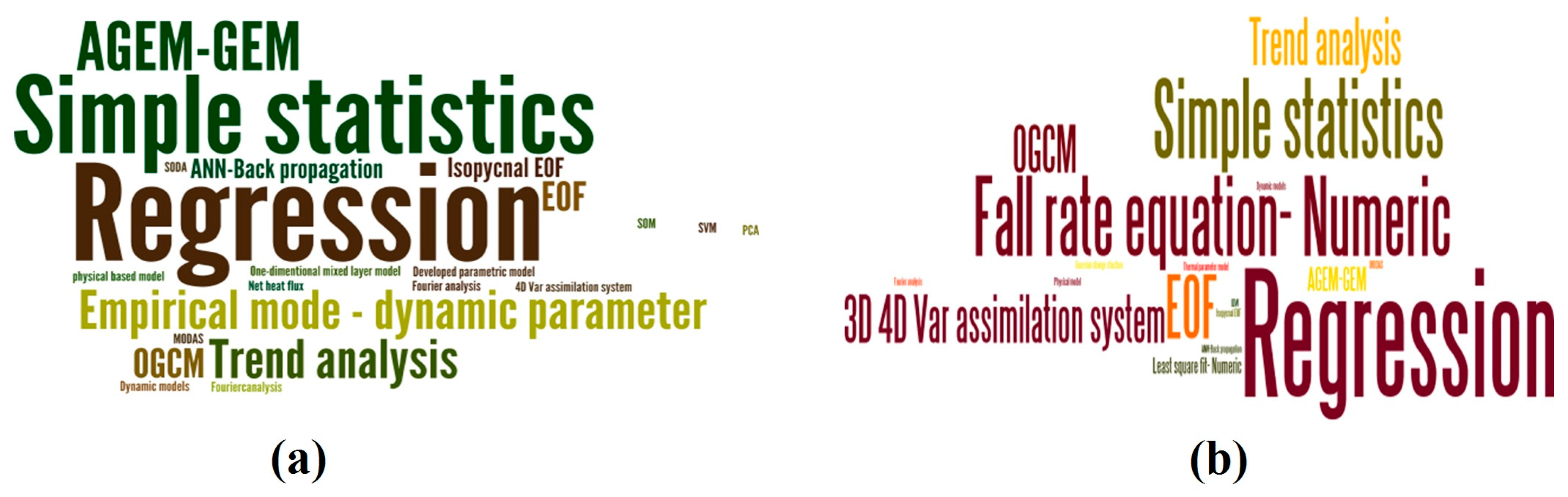
| Category | Name of Techniques | Sensor Type | Year |
|---|---|---|---|
| Simple statistics | Regression | Topex/Poseidon, ERS-1/2 | 1995, 2000, 2001, 2003 |
| GOES | 1983 | ||
| AVHRR, AMSR | 2012 | ||
| M-AERI, NOAA-AVHRR | 2010 | ||
| Jason-1/2, Topex/Poseidon, ERS-1/2 | 2004 | ||
| Topex/Poseidon | 2001 | ||
| AVHRR | 1997 | ||
| Simple statistics, interpolation, comparison | Jason-1, Topex/Poseidon, ERS-1/2, ENVISAT | 2006 | |
| Topex/Poseidon | 1998, 2000, 2001 | ||
| AVISO product | 2009 | ||
| Topex/Poseidon, ERS-1/2 | 2005 | ||
| AMSR-E | 2012 | ||
| Satellite based SST | 2003 | ||
| Trend analysis | AVISO product, NOAA | 2013 | |
| Topex/Poseidon | 2006 | ||
| Jason-1, Topex/Poseidon, ERS-1/2, ENVISAT, NOAA | 2008 | ||
| Topex/Poseidon, ERS-1/2 | 2000 | ||
| Advanced statistics | EOF | NOAA-AVHRR | 2005 |
| GEOSAT | 1990 | ||
| Topex/Poseidon | 2000 | ||
| Fourier analysis | NOAA-AVHRR | 2000, 2005 | |
| Artificial neural network (ANN)-back propagation | AVISO product | 2015 | |
| the temperature sensor | 2004 | ||
| Self-organization mapping (SOM) | AVISO product, NOAA | 2012 | |
| Support vector machine (SVM) | AMSR-E, MIRAS, SMOS, AVISO product | 2015 | |
| Principle component analysis (PCA) | AVISO product | 2009 | |
| Simple ocean data assimilation (SODA) | SMAP | 2016 | |
| Numerical model | Developed parametric model | AVHRR | 2000 |
| One-dimensional mixed layer model | Seasat, Nimbis-7-SMMR | 1981 | |
| Net heat flux physical based model | M-AERI | 2009 | |
| Oceanic general circulation model (OGCM) | NOAA, Topex/Poseidon | 2001 | |
| GRACE, Jason-1, Topex/Poseidon, ERS-1, ENVISAT | 2011 | ||
| SeaWIFS | 2001 | ||
| 4D—Var assimilation system | Topex/Poseidon | 2006 | |
| empirical mode—dynamic parameter | Topex/Poseidon, ERS-1/2 | 2004 | |
| Jason-1/2, Topex/Poseidon | 2006 | ||
| AVISO product | 2009 | ||
| Jason-1/2, Topex/Poseidon, ERS-1/2, ENVISAT | 2010 | ||
| AGEM—GEM | AVISO product | 2010, 2011, 2016, 2016 | |
| AVISO product, Jason-1, ERS-1/2, ENVISAT, NOAA | 2010 | ||
| Isopycnal EOF by considering the dynamic parameter | Satellite altimetry | 1990, 2002 | |
| Modular Ocean data Assimilation System (MODAS) | Seasoar-JES | 2002 | |
| Dynamical models | Nimbis-7-SMMR, NOAA-AVHRR | 1990, 1991 | |
| Nimbis-7-SMMR, NOAA-AVHRR, GOES | 1991 | ||
| NOAA-AVHRR | 1992 |
| Name | Purpose | Location | Methodology | Significant Finding | Suggestion |
|---|---|---|---|---|---|
| Khedouri et al. [51] | Estimate subsurface temperature from satellite altimetry. | Gulf Stream region (analyzed depth: upper 700 m) | The least square linear between XBT measurement and GOES satellite data and inferring subsurface thermal structure from sea surface topography. | There are high correlations between subsurface temperature measured by XBT and sea level height variability measured by GOES, and this relationship can be used to infer subsurface thermal structure. | |
| Fiedler [39] | Detect potential surface manifestations of subsurface thermal structure. | Northern to Southern California Oceanic coastal (analyzed depth: upper 500 m) | Correlation analysis between surface temperature and vertical structure parameters (thermocline strength and mixed layer depth) were applied by linear regression. | Temperature correlation profiles (between surface temperature and subsurface temperature) at different regions and seasons. | Improvement of the precision of vertical structure parameters by considering the sea surface winds from satellite scatterometers or ocean color from new color sensors. |
| Chu et al. [53] | Determine the subsurface thermal structure from satellite SST observation. | South of China sea (analyzed depth: upper 600 m) | Parametric model (relationship between SST and subsurface parameters such as MLD, TBD, and TTG in multi time scales profiles). | The parametric model is more accurate than the simple method of estimating subsurface temperature. | After testing the validity of the multi time scale hypothesis between the mentioned parameters, had better globally apply the multi time scale inverse method. |
| Fischer [56] | Estimating the vertical thermal structure. | Tropical Pacific (analyzed depth: upper 300 m) | Using the SSTA and SSHA data to compute regression matrices that were obtained from a forced integration of the Modular Ocean Model (MOM). | He obtained significantly better results by the multivariate projection method than by the univariate method. | For other regions, other surface observations such as salinity and pressure gradients seem to be necessary. |
| Willis et al. [57] | Estimation of steric height, heat storage, subsurface temperature, and sea-surface temperature variability. | Southwestern Pacific enclosing the Tasman Sea (analyzed depth: upper 800 m) | Combining altimetry height (AH) and SST with in situ data to produce improved estimates of steric height (SH), heat content, and temperature variability by linear regression. | Nine-year time series of heat storage and temperature variability are calculated. The RMSE of estimated approximately was 4.6 W/m2 in heat storage, 0.10 °C in subsurface temperature and 0.11 °C in surface temperature. | |
| Ali et al. [50] | Determination the subsurface thermal structure from surface parameters. | Central Arabian Sea (analyzed depth: upper 300 m) | Estimation of the subsurface temperature from SST, sea surface height, wind stress, net radiation, and net heat flux by neural network approach. | There were proper relationships between the estimated temperature profiles and in situ observations, meanwhile, 50% and 90% of the estimations were a ±0.5 °C and ±1 °C error, respectively. | |
| Guinehut et al. [58] | Estimation of the ocean 3-D temperature fields by combining Argo and remote-sensing data | North Atlantic Ocean (analyzed depth: upper 500 m) | Multiple linear regression was used to derive a synthetic 200-m temperature from simulated altimeter and SST data, then they are combined with individual Argo 200-m simulated temperature to correct the high-resolution synthetic T using an optimal interpolation method. | Obtaining a large reduction of RMSE by combining both data types of the large-scale and low-frequency temperature fields at 200-m depth (by a factor of four in large mesoscale variability regions) as compared to the results obtained using only in situ profiles. | (1) Providing a better estimation of the 3-D thermohaline structure of the ocean by this method. (2) Using the dynamic height instead of sea surface height for reducing the errors due to the regression method. (3) Extending the analyses to other depths and also to the salinity fields. |
| Swart et al. [59] | Estimating GEM and AGEM sections of temperature, salinity, and density. | South-western tip of South Africa and the Antarctic continent (analyzed depth: upper 2500 m) | Using the CTD, satellite altimetry data (SLA, ADT), Argo float data of temperature and salinity and XBT data. 2-D GEM produced, and then dynamic topography data derived from satellite altimetry are combined with the gravest empirical mode (GEM) to obtain a 16-year time series of temperature and salinity fields. | RMSE of assimilation for temperature, salinity, and density is 0.15 °C, 0.02, and 0.02 kg m−3, respectively. | The accuracy of the AGEM to reproduce subsurface thermohaline conditions serves as a catalyst to further studies that utilize time series analysis. |
| Meijers et al. [60] | Estimating the four-dimensional structure of the ocean using satellite altimetry. | Southern Ocean (analyzed depth: upper 2000 m) | By using the altimetry SSH values and Argo floats, a GEM projection of temperature and salinity fields is presented and is used to correlate with the AVISO data to produce gridded, full depth, time-evolving temperature, salinity, and velocity fields. | Strongly correlated with in situ measurements and satellite data for estimating meaningful subsurface properties. The combination of altimetry with the GEM fields allows the resolution of the subsurface structure of the filamentary fronts and eddy features. | Authors confronted the smooth frontal and eddy features due to the limitation of the spatial and temporal resolution of the satellite altimetry, so they suggested the satGEM requires that each dynamic height be associated with just one T–S profile at each longitude. |
| Guinehut et al. [61] | Combining the main components of the global ocean observing system (in situ and satellite altimeter) using statistical methods and deriving high-resolution 3-D temperature and salinity fields. | Atlantic, Pacific, and Indian Oceans (analyzed depth: upper 1500 m) | Deriving synthetic temperature fields from altimeter and sea surface temperature observations and salinity fields from altimeter observations, through multiple/simple linear regression methods. Then combining the synthetic fields with in situ temperature and salinity profiles using an optimal interpolation method. | Up to 50% of the variance of the temperature fields can be reconstructed from altimeter and sea surface temperature observations and a statistical method. Because of reconstructing only about 20 to 30% of the signal altimeter observations for salinity, making the in situ observing system essential for its estimates. | In this study, only thermohaline fields are presented, but the Global Ocean Observation-based products also include 3-D geostrophic velocity estimates that are calculated using the thermal wind equation combined with absolute surface altimeter geostrophic currents and can be used towards integrating climate-relevant global ocean Datasets. |
| Wu et al. [41] | Estimation of subsurface temperature anomaly by remote sensing data. | North Atlantic Ocean (analyzed depth: upper 2000 m) | Training self-organizing map (SOM) neural network method using anomalies of SST, SSH, and SSS data from Argo gridded monthly anomaly datasets in order to estimate a STA. | Estimating STA time series for 1993–2004 from remote sensing SST. Obtaining good agreement between the STA estimations from the SOM algorithm and in situ measurements taken from the surface down to 700-m depth. SOM algorithm can only predict the STA that lies in the range of labeling data. | |
| Su et al. [31] | Determining the subsurface temperature anomaly by satellite measurements (AMSR-E, MIRAS, AVISO altimetry). | Indian Ocean (analyzed depth: upper 1000 m) | Estimation STA from a suite of satellite remote sensing measurements including SSTA, SSHA, and SSSA by the support vector machine. | Detecting the SSTA, SSHA, and SSSA parameters had improved and describe the STA estimation accuracy. | Providing a useful technique for studying subsurface and deeper ocean thermal which has played an important role in global warming. |
| Measurement from Space | 2010 | 2020 | 2025 |
|---|---|---|---|
| Sea surface height (SSH) | 100-km spatial scales; 10-day revisit (Topex/Jason series) | 10-km spatial scales; 10-day revisit (SWOT) | 10-km spatial scales; 1-day revisit (multiple SWOT satellites) |
| Ocean vector winds (OVW) | 25-km spatial scales; 1–2 day revisit (QuikSCAT/ASCAT) | 3–25 km spatial scales; 6-h revisit (XOVWM/ASCAT/Oceansat 2) | 3-6 km spatial scales; 6-h revisit (XOVWM and follow-ons) |
| Ocean surface salinity (SSS) | 150–200 km spatial scales; 30-day time scale (SMOS in 2009; Aquarius in 2010) | 40-km spatial scales; 10–3-day time scale (SMAP) | 20-km spatial scales; 7-day time scale (Aquarius follow-ons) |
| Sea surface temperature (SST) | 1-2-km spatial scales; 1-day revisit; no visibility through clouds (MODIS) | 1–2 km spatial scales; <1-day revisit; no visibility through clouds (VIIRS) | 1–2 km spatial scales; <1-day revisit; no visibility through clouds (VIIRS) |
| 40-km spatial scales; 1-day revisit; all-weather (AMSR-E) | 40-km spatial scales; 1-day revisit; all-weather (AMSR-E) | 1–2 km spatial scales; 1-day revisit; all-weather (next-generation micro-wave radiometers) |
© 2017 by the authors. Licensee MDPI, Basel, Switzerland. This article is an open access article distributed under the terms and conditions of the Creative Commons Attribution (CC BY) license (http://creativecommons.org/licenses/by/4.0/).
Share and Cite
Akbari, E.; Alavipanah, S.K.; Jeihouni, M.; Hajeb, M.; Haase, D.; Alavipanah, S. A Review of Ocean/Sea Subsurface Water Temperature Studies from Remote Sensing and Non-Remote Sensing Methods. Water 2017, 9, 936. https://doi.org/10.3390/w9120936
Akbari E, Alavipanah SK, Jeihouni M, Hajeb M, Haase D, Alavipanah S. A Review of Ocean/Sea Subsurface Water Temperature Studies from Remote Sensing and Non-Remote Sensing Methods. Water. 2017; 9(12):936. https://doi.org/10.3390/w9120936
Chicago/Turabian StyleAkbari, Elahe, Seyed Kazem Alavipanah, Mehrdad Jeihouni, Mohammad Hajeb, Dagmar Haase, and Sadroddin Alavipanah. 2017. "A Review of Ocean/Sea Subsurface Water Temperature Studies from Remote Sensing and Non-Remote Sensing Methods" Water 9, no. 12: 936. https://doi.org/10.3390/w9120936