Review

Re-Thinking Urban Flood Management—Time for a Regime Shift

1
Water Resources Engineering, Lund University, Lund SE-221 00, Sweden
2
GIS Centre/Physical Geography and Ecosystem Science, Lund University, Lund SE-221 00, Sweden
3
Architecture and Built Environment, Lund University, Lund SE-221 00, Sweden
4
Water and Environmental Engineering, Lund University, Lund SE-221 00, Sweden
5
Faculty of Culture and Society, Malmö University, Malmö SE-205 06, Sweden
6
AgriFood, Economics Centre, Lund University, Lund SE-220 07, Sweden
7
Risk Management and Societal Safety, Lund University, Lund SE-221 00, Sweden
8
Center for Middle Eastern Studies, Lund University, Lund SE-221 00, Sweden
9
VA Syd, Malmö SE-211 20, Sweden
*
Author to whom correspondence should be addressed.
Water 2016, 8(8), 332; https://doi.org/10.3390/w8080332
Submission received: 7 June 2016 / Revised: 27 July 2016 / Accepted: 2 August 2016 / Published: 4 August 2016
(This article belongs to the Special Issue Urban Water Challenges)

Abstract

:
Urban flooding is of growing concern due to increasing densification of urban areas, changes in land use, and climate change. The traditional engineering approach to flooding is designing single-purpose drainage systems, dams, and levees. These methods, however, are known to increase the long-term flood risk and harm the riverine ecosystems in urban as well as rural areas. In the present paper, we depart from resilience theory and suggest a concept to improve urban flood resilience. We identify areas where contemporary challenges call for improved collaborative urban flood management. The concept emphasizes resiliency and achieved synergy between increased capacity to handle stormwater runoff and improved experiential and functional quality of the urban environments. We identify research needs as well as experiments for improved sustainable and resilient stormwater management namely, flexibility of stormwater systems, energy use reduction, efficient land use, priority of transport and socioeconomic nexus, climate change impact, securing critical infrastructure, and resolving questions regarding responsibilities.

Graphical Abstract

1. Introduction

Urban flooding problems are increasing due to numerous reasons. Urbanization is an accelerating trend. At present about 54% of the global population live in cities [1] and by 2050, almost two thirds of the world’s population will live in urban environments [2]. Thus, urban areas are growing and in many cases, they are becoming denser [3]. Many cities are striving to reduce their negative, environmental impact and densification of existing urban areas has become the dominating urban planning strategy in order to meet a rapid urbanization with limited expansion on agricultural land [4,5]. The large proportion of impermeable surfaces makes built-up land more vulnerable to flooding than the surrounding environment. Moreover, the risk of being flooded due to sea level rise or river discharge is threatening 15% of the world’s population [2]. Recently, severe flooding hit highly developed cities like Prague, Dresden, and several other cities (2002), Bern and several other cities (2005), New Orleans (2005), Copenhagen (2010, 2011, and 2014) (Figure 1), and New York (2012), as well as areas like Queensland (2010), South-western England (2013–2014), and the French Riviera (2015). The societal consequences are severe. In Europe only, the average cost of flood damages between 2000 and 2012 has been estimated to about 4.9 billion euros per year. It is estimated that this figure may increase to about 23.5 billion per year by 2050, i.e., with almost 400% [6].
The traditional engineering approach to manage urban drainage is by combined (sewage water and stormwater in the same pipe) or separate pipe systems. In semi-urban catchments, urban drainage systems may be combined with dams, levees, and other types of storage and detention facilities to cope with floods. However, during recent decades alternative ways to manage floods have evolved since traditional methods often harm the riverine ecosystems in urban as well as rural areas and increase the long-term flood risk [7,8]. Alternative methods relate to resilience theory and address the city’s capacity to mitigate flooding in particularly sensitive urban areas, tolerate controlled flooding on assigned areas, and to re-organize in case of damage. This means that adaptive, multifunctional infrastructure in combination with water sensitive urban design are seen as means to reinforce resilience against climate change [9,10,11]. However, incorporation of these measures into decision-making and ways to handle integrative and multi-criteria aspects in the legal and organizational system are still to a great extent undeveloped. In general, a design framework integrating technical, social, environmental, legal, and institutional aspects is crucial [12]. Introducing such a framework is faced with barriers that are largely socio-institutional rather than technical [13].
Sustainable and resilient water management thus needs to involve water supply access and security, public health protection, as well as flood protection in densely built urban areas with many types of important urban infrastructure [10]. In view of the above, it is clear that urban water management systems need to become integrated elements in a multifunctional urban environment. Increasingly urgent and complex problems have to be solved by the city, where the water sector management systems should be developed in close collaboration with regional and municipal planning authorities.
The traditional thinking is that resilient societies bounce back from the state they were in before a devastating event. However, lessons learned, from for example the Hurricane Katrina in 2005, show that this may not the case. Ten years after the catastrophe, the area is still suffering from reduced long-term population and low economic activity [14]. Thus, instead of viewing the drainage design as a static process and to cope with floods of a certain recurrence, a contemporary interpretation of urban resilience needs to encompass a more flexible and adaptive approach to flood management. A flexible flood management system may be defined as measures for a given level of flooding, but with an integrated ability to modify it later [15]. Urban resilience should be viewed as an adaptive process where the society continuously learns how to cope with changing socioeconomic conditions and urban land use as well as a changing climate. Since the urban space and flooding are complex, it is necessary to adopt a systems-analytical approach. Figure 2 outlines the three systems involved in urban flood problems, namely (1) the hydrological system; (2) the impact system; and (3) the management system. For a systematic approach to flood resilience, the dynamic character of all three systems needs to be considered.
A new adaptive approach to urban water management has to be integrated among stakeholders and authorities and by using sustainability criteria. It should secure a higher level of resilience to climate change and water services, while at the same time enhancing attraction and social inclusion of urban environments. In this regard, the complex function of urban areas needs to be weighed into the design process. In view of the above, the objective of this paper is to bring forward the concept of urban flood resilience into a context of sustainability and risk management. We elaborate on these concepts according to the concept graph in Figure 3 and point out areas where an updated approach serves to cope with changing risks and increase urban resilience through integrated flood management.

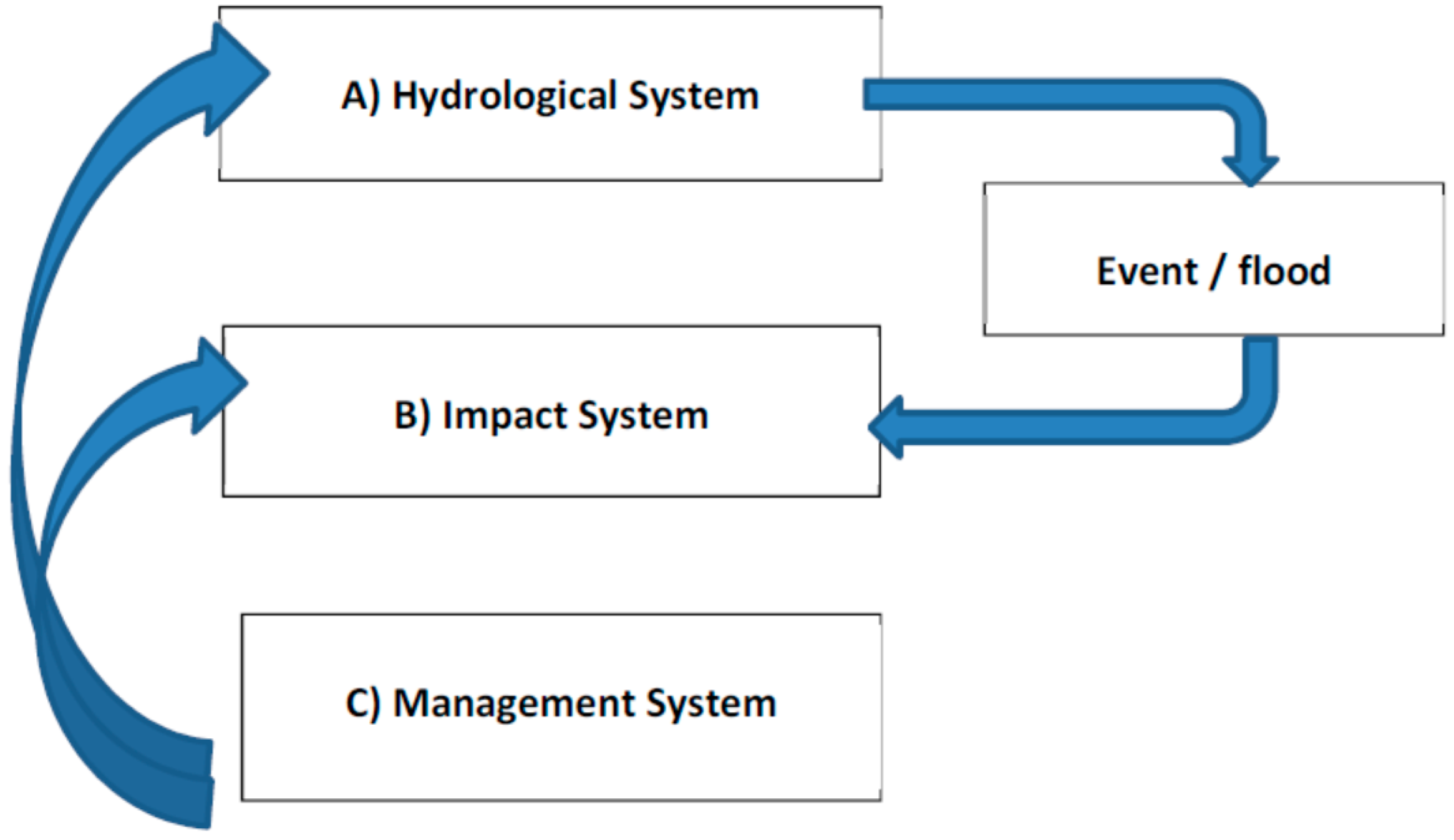
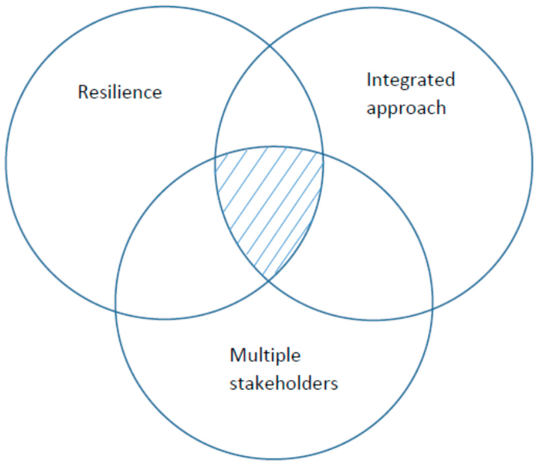
2. Resilience in Flood Management

As mentioned above, resilience is a key notion in sustainability science and contemporary urban flood management. For this purpose, we give a brief account of this concept in relation to risk below.

2.1. Concepts of Risk and Resilience

Although risk is a contested concept with numerous definitions [16], most characterizations have three aspects in common [17], namely (1) The assumption that the future is uncertain [18,19] and that any future event is possible to influence [20]; (2) the uncertain future has a potential impact on humans [18,21], or can at least be so perceived [22]; and (3) risk is defined in relation to a preferred outcome [20,23,24]. Thus, risk is a potentially negative deviation from a preferred expected development over time. This definition may at first appear as merely complicating more conventional approaches to risk, such as a combination of probability and consequence or of events and consequences and their associated uncertainties, but even so may serve its purpose [16].
The notion of resilience is usually used to describe (1) the ability of a system to “bounce back” to a single equilibrium [25,26]; (2) a measure of robustness or buffering capacity before a disturbance forces a system from one stable equilibrium to another [27,28]; or (3) a system’s ability to adapt in reaction to a disturbance [29]. It has been suggested that human beings have the ability not only to react to disturbances but also to anticipate and learn from them [17]. Resilience can be regarded as a purely descriptive concept in relation to systems behavior, or if it is normative in the sense of relating outcomes to human values and objectives. Both approaches have merits, but if resilience is to have any meaning in relation to risk and sustainable development, which are both inherently normative concepts, it becomes equally normative [17].

2.2. Flood Resilience

Urban flood risk management aims at assessing and reducing flood risk, as well as preparing for effective response to, and recovery after, actual floods, with the purpose of minimizing disturbances, disruptions, and associated costs in relation to a city’s preferred development over time. Thus, resilience is the capacity of a system, such as a city, to continuously develop along a preferred and expected trajectory [17], while remaining within human and environmental boundaries [30]. This approach to resilience is suitable when focusing on the sustainable development of cities, which entails human beings with preferences and expectations for their future as well as agency to strive to meet them. City authorities develop visions and plans for the future use of urban areas. Plans may span over years and even decades, during which the city changes more or less continuously and most often significantly due to purposeful and proactive human activities, also often reducing the applicability of all three main approaches to resilience previously listed. If a city’s resilience instead is its capacity to continuously develop along its preferred expected trajectory, then this resilience is an emergent property determined by the city’s ability to anticipate, recognize, adapt to, and learn from variations, changes, disturbances, disruptions, and disasters that may cause harm to what human beings value [17]. Sustainable development thus means to manage risk and resilience is the capacity for doing so in an uncertain, ambiguous, complex, and dynamic world.

2.3. Time Perspective on Flood Management

Long-term strategies are needed to facilitate cost-effective and rapid implementation of integrated flood management [31]. The aim is fast recovery from flooding and restoration to good living conditions. Sustainability should not only be achieved economically, but also socially and environmentally [32]. Cities are challenged by climate change, and according to the European Environmental Agency report [33] immediate action is needed since delaying adaptation actions will be much more costly in the long-term. Climate change will not only affect the economy but also increase the number of possible hazardous events to citizens. When planning for climate change, however, also other related climate change effects such as, water scarcity, drought, and heat waves, need to be considered in the municipal planning. Cities should thus, not wait for a larger flood event or a large-scale catastrophe to act. Instead, city planners need to study front-runner cities that are dealing with flood challenges such as New York, Copenhagen, and Rotterdam. Learning from the experiences of others, and ourselves is of crucial importance and saves energy, resources, and time [34]. Thus, it is a long-term process to achieve a flood resilient city, and it is vital to ensure synergy between urban development and urban drainage strategies [35]. It is dangerous to make long-term decisions based only on experiences of a recent severe flood event. Doing so might lead to lock-in effects where irreversible decisions are made [36].

2.4. Flood Management Strategies

After a series of catastrophic floods in Europe, the EU Flood Directive was ratified in 2007 [37]. The Flood Directive gives two design levels, namely the 100-year event, and the “worst case scenario”. Implicitly the Flood Directive focuses on riverine floods. However, pluvial floods, i.e., flooding generated locally by an overload of the urban drainage system by extreme rainfall, also constitute a formidable threat to cities around the world. Since traditional urban drainage systems rely on underground pipes, they have, in order to avoid huge dimensions, typically been designed to cope with rainfall of 10 year recurrence period or less. More extreme events are deliberately allowed to generate inundation of selected areas such as streets, infrastructure, and building basements. Even with design level of 100 year recurrence period, the risk of exceeding critical conditions during a period of 50 years is 40%. On top of that, the uncertainty associated with recurrence periods based on existing, limited data is quite large [38]. The EU Flood Directive highlights that, irrespective of the recurrence period chosen, there is always a non-negligible probability of system failure. Unfortunately, it remains to make this an accepted public fact and a component of the strategic thinking among all stakeholders including especially the general public.
As climate change continues and the sea level rises [39], concerns regarding coastal flooding are growing. Three different strategies have been suggested [40,41], i.e., to retreat (slowly move buildings to higher elevations), to defend (secure areas with measures like dikes and floodgates), or to attack (build on the water, with buildings and infrastructures that can endure the water). From an environmental perspective, retreat or attack is most suitable, while defend is found less advisable. From an economical perspective, defend or attack is most suitable if there are high assets in the area, and defend will minimize the construction and maintenance costs. From a social perspective, the retreat might be a good solution [41]. Mathur, A. et al. [42] discussed flooding and sea level rise for Mumbai (India) and suggested that the sea should be seen as a friend rather than an enemy from which to be protected. Further, the islands of Mumbai should more correctly be called estuary and Mithi River a river rather than a part of the sewage system. They argued that the change in naming and understanding are important for how we reflect upon the nature as well as the city and that this influences how we plan the city and prepare ourselves for flooding.
In general, coastal flooding is different from riverine (from river) and pluvial (from intense rainfall) flooding with respect to physical planning. Cities are often experiencing a combination of riverine and pluvial floods. The pluvial flood type is generated locally and the result of exceedance of natural infiltration and drainage as well as exceedance of the capacity of the urban drainage system [43]. On the contrary, riverine floods are usually generated at a much larger rural catchment scale. Consequently, the flood problem for riverine cities may often be a result related to scale and upstream rainfall-runoff processes. Consequently, upstream flood management will also affect the downstream water level and discharge. In this regard sustainable flood management for urban areas needs to consider larger, often rural catchments that discharge nearby or inside urban neighborhoods as well as direct stormwater runoff from impermeable areas. This can be seen as a scale problem where both quantitative and qualitative aspects of runoff need to be considered. Nevertheless, the problem is similar when it comes to organizational strategies and the understanding of resilience and risk.

3. Integrated Approach to Urban Planning and Design

To manage floods in a sustainable way it is necessary to apply a holistic viewpoint and employ an integrated approach for the different functions that a modern city entails.

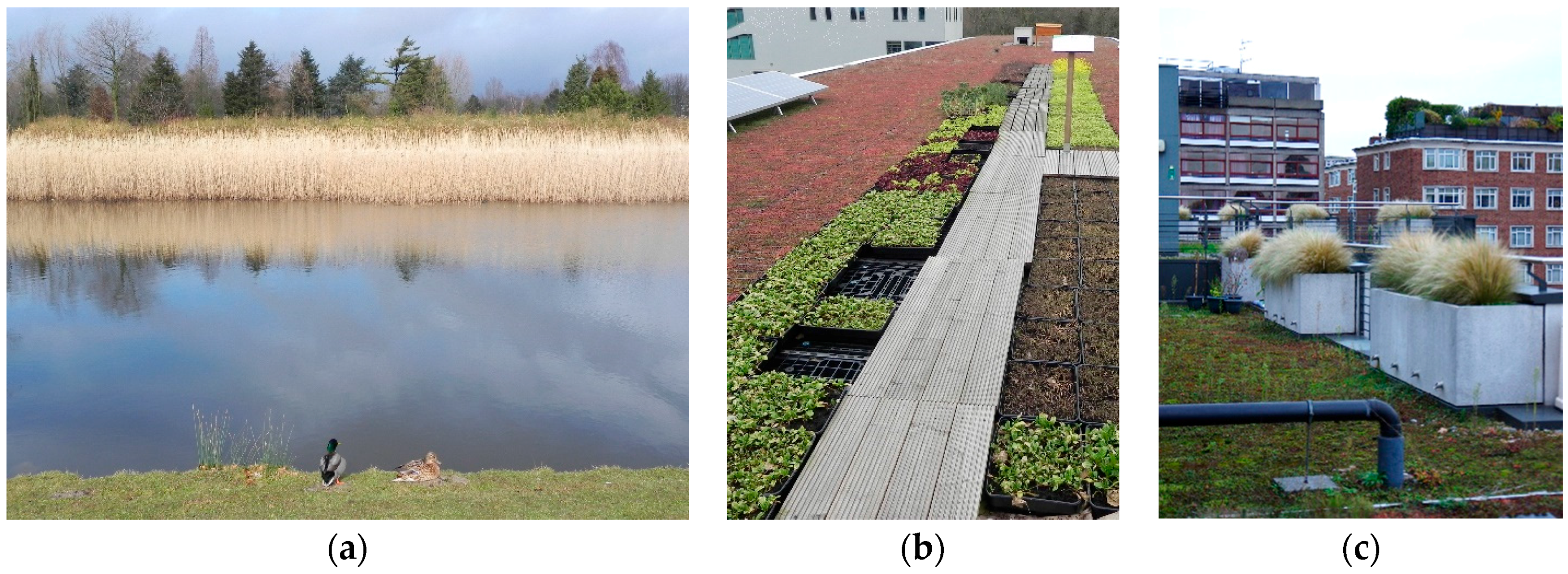
3.1. Water Management beyond the Traditional Pipe System

Continuous urbanization will result in increasing nutrient and contaminant emissions of watersheds, putting human health and ecosystems in danger [44,45]. Due to the absence of trans-scale thinking, drainage and flood protection systems mostly rely on expensive and inflexible underground solutions. High-intensive rainfall is causing more frequent overloading of pipes resulting in flooding of public and private property [46]. As most cities still are using combined sewage systems for drainage, more frequent overflow of untreated sewage may be expected in the future [46]. At the same time, urban areas are getting denser, and thus less space will be available for underground infrastructures including extensive use of drainage pipes. Developing the underground water infrastructure will thus be even more costly in the future. Urban transition should instead lead towards less and slower surface runoff, which requires more soil and surface infiltration. Accordingly, applying surface solutions and evolving the drainage systems are essential steps for the reduction of flood impacts [47]. Utilizing urban areas as integrated parts of the drainage system provides promising opportunities.
Geldof, G.D. [48] suggested the Three Point Approach (3PA) as a tool for how to move from only focusing on design standards for rainfall events that occur with a return period of 1 in 10 years (first point) to including extreme rainfall events (second point), and at the same time consider the impact on every-day life (third point). Fratini, C.F. et al. [49] found this tool useful in discussions with stakeholders. Rather than seeing the 3PA as going from a one-point to a three-point approach, the present flood management could be developed from a single-purpose view with a one-point approach to a multi-disciplinary view with a full spectra approach. This means that the whole range, from the everyday system and processes in the city to the functionality during the most extreme events, is incorporated. The whole system can be integrated and treated in unison, including also extremes. It is no longer appropriate to focus separately on the water issue solely when planning water infrastructure. For economical as well as environmental reasons, an integrated approach is needed. New large-scale single-purpose construction projects, such as huge sewerage tunnels in old combined sewerage systems, have been strongly criticized, for example in Philadelphia [50,51], London [52] and Copenhagen. Integrated flood management calls for solutions with multiple purposes, which has a valuable function every day, not only once in 50 or 100 years. With climate change and rapid urbanization, there is also a need to increase the capacity of the stormwater system. At the same time, since urban areas are becoming more complex including more and more high-tech and sensitive infrastructures, the economic value is increasing leading to larger flooding sensitivity. Therefore, more flexible systems are needed that can adapt to future changes.

3.2. Integrated Approaches to Flood Management

Designing open water management solutions in the urban landscape is a multi-disciplinary task that requires a combination of scientific and artistic approaches and a new kind of interaction between green and blue assets is called for [53]. Different mechanisms for infiltration, storage, transport, evapotranspiration, and treatment are usually applied in surface solutions [54]. In blue-green infrastructure, the urban greenery and water management are combined in order to protect the urban landscape and its ecological and hydrological values [55,56]. In successful examples, blue-green infrastructure not only mitigates flood impacts [57] and improves adaptation to climate change, but also increases the quality and living conditions of urban environments in terms of improved heat alleviation, increased biodiversity, and better air quality. It may even have the potential to provide for food and energy production, improve local economy, and benefit social life [58]. Ecological urbanism makes it possible for both water flow and urban landscape to act as mutual drivers and at the same time, values are added to the public urban space. Due to historical reasons, most cities have today mainly piped drainage and a flood control system for pluvial flooding [13,59]. Transfer towards blue and green solutions will be slow and many challenges regarding responsibility, economy, and maintenance are yet to be solved.
Increased frequency and intensity of heavy rainfall are affecting private and public stakeholders and municipal authorities. Compact solutions and efficient land use are called for in both new areas and redevelopment in urban areas. Densely built urban areas should provide easy and convenient access to a multitude of functions such as retail, service, and public transport, thereby contributing to reduced energy use and CO2 emissions [5]. This means that a wide range of everyday activities is carried out simultaneously in densely built urban environments. The value of urban land is high and thus urban space has a multitude of functions (Figure 4). Strategies to address water challenges at early stages and implement integrated site-specific urban drainage solutions in all urban projects are essential [35].
Several critical considerations need to be taken when introducing flood preventing measures above ground to assure that retention ponds, permeable surfaces, and open swales are adding to, rather than subtracting from, the experiential and functional quality of everyday living environments for urban dwellers (Figure 5). For instance, sustainable urban environments need to prioritize non-motorized travel modes such as walking, bicycling, and the use of public transport [60]. Special attention needs to be given to vulnerable and less mobile groups such as children, elderly people, and those with physical or visual impairment. It is therefore crucial to include designers with expertise in urban landscaping and social structures in the design process, to make sure that new designs meet the requirements for all users. With multipurpose solutions, increased complexity in the design process will follow. Water planning and urban planning integration are thus keys to flood resilience. The focal points should be at improving the spatial and economical values of the use of water in the city, protecting the city against sea level rise and river discharge, and increasing resilience to stormwater. Solutions should consist of the combination of planning, technology, and design. Accordingly, merging different urban projects and taking advantage of various sectors, working groups, and experts are necessary [61].

3.3. Importance of Planning for Sensitive Infrastructure

Flood events pose special threats to society through the effects on infrastructure. Large quantities of water may flood buildings and cut off roads. Flooded buildings with sensitive equipment such as electrical and IT systems may have devastating societal effects. Moreover, since sensitive infrastructure systems usually are connected and interdependent, effects may cascade to other systems and over a much larger area than the initially affected one [62,63]. Additionally, the consequences may occur instantly or show up later making it very difficult to assess the consequences that a flood event may have on society as a whole [64,65]. This is serious since the infrastructure is often critical for society’s function to work properly and deliver basic services and supplies to its inhabitants, such as fresh water and electricity. This is especially true for urban environments with no or few alternatives to the failed infrastructure. Moreover, vital societal functions, such as hospitals, may not tolerate interruptions in water supply, electricity, as well as transportation. Hence, it is paramount that effective planning measures for protecting the infrastructure are developed and implemented. Considering the damages flooding causes worldwide there is still much to do when it comes to protecting the sensitive infrastructure from being damaged or affected by flooding.
From the above, it is clear that planning is essential for protection of vital infrastructure when dealing with disaster risk management. Not only flooding, but also other potential threats to a functional society, have to be taken into account when designing and building infrastructure. We have to make sure that water, transportation, energy, and other important infrastructures are protected in non-normal situations, like during flood events. A way to prepare the society is to simulate different scenarios by applying disturbing factors. Using modern technology, like up to date spatial planning techniques, makes it possible to integrate a large number of societal threats and optimize solutions [66]. Solutions can also be based on different priorities, such as cost-benefit, time, or environment [67]. For this purpose, adequate and high quality data are a necessity to make simulations trustworthy, as even small errors in these datasets will highly influence the results [68]. The scale and accuracy challenge makes the planning site specific, and does not allow for spatial generalizations. Coombes, P.J. [68] noted that an appropriate policy framework is required that integrates land and water management with design processes at spatial scales from local to regional and that also applies to urban renewal and asset renewal or replacement choices. However, integrative aspects may as well lead to competing scales of issues and inertia of existing systems may severely challenge innovative facets of solutions [69].

4. Flood Management with Multiple Stakeholders

4.1. Roles and Responsibilities

The water supply and water sector is arguably the local activity that is first to be exposed by a changing climate and increased flood risk. However, the water sector cannot be expected to handle the complex problems by itself only. To find cost-effective solutions, public and private actors at the local and national level must cooperate and share the responsibility to reduce the negative effects of flooding. For the water sector, this would call, e.g., for measures to integrate water management with a wider planning system, such as land-use planning and development of transport systems, and decentralized blue-green solutions to handle stormwater. Future effects of climate change are also expected to vary considerably, due to, e.g., variation in local climate as well as variation in natural and social conditions. These characteristics make adaption to climate change and flood control a local task [70]. There is, thus, a need for differentiated and flexible measures. For example, giving responsibility to different sectors at the local level can motivate them to seek cross-sector cooperation where they find this relevant [70]. For this to function, stricter central government regulations may be necessary. Adopting a highly decentralized organization is not without problems. [71,72] studied the effects of introduction of a revised system of funding flood management schemes in England, the ‘Partnership Funding’ [73]. The results suggested, e.g., that the economic efficiency did not increase. Instead, higher costs resulted due to longer decision-making practices. In addition, the scheme increased social inequality, where rural middle-class groups with local capacities, such a networks, skills, and cultural capital, gained from the funding scheme. Hovik, S. [72] concluded that there is not necessarily a contradiction between strong vertical links and a strengthening of horizontal cooperation in a system of network governance. Although in the resilience literature decentralized and deregulated risk management systems have been suggested, often as part of a neoliberal policy agenda [74,75,76], there is nothing in the concept itself that disqualifies all levels to take active part. In other words, just because individuals, households, and communities become involved, the state is not restrained from a central role in a resilient city. A characteristic of the 20th century was development of utility services that did not require the citizens’ active behavior. With regard to solid waste, citizens need to and are willing to interact with this system on a wider basis. It may well be that we now see changes also with regard to water, where the citizens have to interact and be part of the system. For this to take place, support by legislation is required. The Danish law on sky burst management may well be the first example of this. The concept requires an environment where different techniques are allowed to co-exist as different possible ways to solve multifunctional goals.

4.2. Multi-Stakeholder Planning

To facilitate multi-stakeholder planning, it is first necessary to identify all relevant stakeholders in a given area and create forums in which they can communicate their specific interests and needs to each other [77]. There is also a need to increase the stakeholders’ knowledge and understanding about flooding as phenomena as well as how flooding may affect specific urban locations. The stakeholders need to work with and see the result of reliable flow models that can visualize how flooding may develop at these locations. The stakeholders also need to increase their understanding on how flooding may affect the infrastructure in these places and how the effects may spread from one system to another. This calls for solutions where it is possible to illustrate and visualize how exposed the infrastructure is to flooding and collectively analyze what the effects flooding may have on infrastructure and society. The analysis can be refined by clarifying the sensitivity of the different infrastructures, their interdependences, and the functions they support. An exciting way to perform this analysis may be to use social media and techniques in virtual reality (VR) or augmented reality (AR). A common denominator is to improve the communication between stakeholders before, during, and after flood events.
A major challenge concerns the implementation of effective measures. Although the infrastructure is connected, the responsibility, ownership, and competence are often separated, adding to the difficulties to obtain a holistic perspective and a general understanding among the stakeholders. This is further complicated by the fact that information about infrastructure may be sensitive and therefore cannot be openly communicated. Moreover, the divided responsibility makes it difficult to implement cost effective measures since cost and effect may be separated for different actors and systems. Hence, there is a need to encourage formation of joint priorities and objectives among all stakeholders. For a holistic flood risk planning to function, the planning process must be imbued by a high degree of communication and collective learning. Collective learning can be defined as “…a broad term and includes learning between dyads, teams, organizations, communities, and societies” [78]. It stresses “…characteristics such as relationships, shared vision and meanings, mental models and cognitive and behavioral learning” [78].
Zhou, Q. [12] provided a general summary of the capacity of various models and software in terms of water quantity and quality simulation, sustainable drainage device modeling, and spatial planning. It is important that the multi-stakeholder planning involves a presentation and motivation of selected models for the quantitative and qualitative modeling. A general concern, however, for these models is the lack of a shared interface/platform for integrated use. Many models are specialized for only one or a few aspects of SUDS (Sustainable Urban Drainage System) and therefore the simulation is often performed in isolation and thus only partially reveals all effects of SUDS. For a detailed discussion of models see [12]. A possible way to better integrate hydrological and hydraulic model results into multi-stakeholder planning is the use of Geographic Information Systems (GIS).

4.3. Information Sharing between Stakeholders

Geographic Information Systems (GIS) is an effective tool for building databases and analyzing spatial data, and may be of great help for accomplishing learning across organizational boundaries. GIS enables numerous types of analyses based on, e.g., proximity and network. In addition, the effective visualization capability of a GIS makes it highly suitable for learning and communication activities. As a result different forms of collective GIS-approaches have emerged, e.g., community mapping and participatory GIS. GIS is also used and developed for improving (flood) risk management. GIS has, e.g., been used for identifying interdependencies between local infrastructures [65], modeling and simulation of infrastructure elements interdependencies [79], and modeling urban surface water balances [80].
Shared responsibility and access to databases and analysis results are essential for successful planning as discussed above. One way of implementing this is by the use of a spatial data infrastructure (SDI) that is available on the Internet [80]. Integrated systems and integrated spatial data infrastructures (see e.g., [81,82,83]), are essential to make information available and create possibilities to include various types of data from different stakeholders. SDI makes it possible for data providers, including participatory data collection made by the broad society, to contribute in building information databases, to be used for planning as well as for awareness and protective measures. Web-based solutions make it possible for responsible parties (like municipalities) to retrieve data and information on a detailed level and for the public to get up-to-date information when needed. All stakeholders are also able to feed the system, through database writing permission set by the authorities [84,85]. This means that parts of the system are publicly available, while other parts are restricted to planners and officials only.

5. Discussion and Conclusions

In the above, we elaborated on concepts related to urban flood resilience and pointed out several areas where the society needs to change the thinking to reach our goal: an integrated flood management system that can cope with changing risk by increasing urban resilience. In addition to an active civil society, effective urban water governance is also required. It is crucial to realize that cities are urban socio-ecological systems where multiple stakeholders can jointly develop multiple-purpose solutions to the complex problem of flood prevention in densely built urban areas. There are several challenges that still call for a solution, and the more important ones are summarized below. Transdisciplinary research has the potential to identify obstacles, learn from successful examples, promote the development of new processes, and to support progress in the mentioned areas.
1.
Climate change and related impacts
Future flood protective measures should be climate change resilient. However, also other related climate change effects such as, water scarcity, drought, and heat waves, need to be considered in the municipal planning.
2.
Water, energy, land use, transportation, and socioeconomic nexus
The urban water system has traditionally been regarded as a stand-alone system. To develop flexible, resilient, and multipurpose flood protection systems, the water, energy, land use, transportation, and socioeconomic nexus need to be jointly considered from a multi-stakeholder perspective (see also e.g., [86]).
3.
Flexibility of different kinds of stormwater systems
Flexibility of flood protective measures is paramount. Urbanization as well as the changing use of urban areas imply that flexibility in measures against floods becomes very important. Flexibility is also needed in view of uncertain future climate change impact.
4.
Unresolved questions regarding responsibilities and improved communication between stakeholders and authorities.
Sustainable flooding and resilience thinking to flood prevention need better integration among stakeholders and authorities managing flooding. Flooding, like other sudden events, may change the city from one state to a new, different one (especially for catastrophic events). This understanding opens up for new approaches to urban planning. In this process, the responsibility of different sectors of city and planning authorities needs to be clarified.
5.
Securing critical infrastructures
Important societal sectors may be highly dependent on certain infrastructure and different flows of supplies, e.g., the health care sector. Methods and tools to clarify the infrastructures’ vulnerability to flooding can involve simulations, which are efficient in visualizing and have predictive capability; integrated databases; broad participation of many stakeholders with varying interests; and collective learning efforts that enhance information sharing. There is a need to reflect carefully on these and other methods and tools, and consider how they can be implemented effectively in the flood risk management work.

Acknowledgments

This research was funded by The Swedish Research Council Formas under contract 942-2015-149. Financial support was also provided by Sweden Water Research, Göteborg City, Höje å Water Council, the Skåne Region, and Länsförsäkringar Skåne.

Author Contributions

All authors contributed equally in writing the manuscript.

Conflicts of Interest

The authors declare no conflict of interest.

References

  1. United Nations. World Urbanization Prospect; The Revision 2014. Highlights; UN: New York, NY, USA, 2014. [Google Scholar]
  2. Ligtvoet, W.; Hilderink, H.; Bouwman, A.; Puijenbroek, P.; Lucas, P.; Witmer, M. Towards a World of Cities in 2050. An Outlook on Water-Related Challenges; Background Report to the UN-Habitat Global Report; PBL Netherlands Environmental Assessment Agency: The Hague, The Netherlands, 2014. [Google Scholar]
  3. Remondia, F.; Burlando, P.; Vollmer, D. Exploring the hydrological impact of increasing urbanisation on a tropical river catchment of the metropolitan Jakarta, Indonesia. Sustain. Cities Soc. 2016, 20, 210–221. [Google Scholar] [CrossRef]
  4. Ståhle, A. Compact Sprawl: Exploring Public Open Space and Contradictions in Urban Density; School of Architecture, KTH: Stockholm, Sweden, 2008. [Google Scholar]
  5. Talen, E.; Ellis, C. Compact and diverse: The future of American urbanism. Hot, congested, crowded and diverse: Emerging research agendas in planning. Prog. Plan. 2009, 71, 153–205. [Google Scholar]
  6. Jongman, B.; Hochrainer-Stigler, S.; Feyen, L.; Aerts, J.C.J.H.; Mechler, R.; Botzen, W.J.W.; Bouwer, L.M.; Pflug, G.; Rojas, R.; Ward, P.J. Increasing stress on disaster-risk finance due to large floods. Nat. Clim. Chang. 2014, 4, 264–268. [Google Scholar] [CrossRef]
  7. Liao, K.-H. A theory on urban resilience to floods—A basis for alternative planning practices. Ecol. Soc. 2012, 17, 48. [Google Scholar] [CrossRef]
  8. Smits, A.J.M.; Nienhuis, P.H.; Saeijs, H.L.F. Changing estuaries, changing views. Hydrobiologia 2006, 565, 339–355. [Google Scholar] [CrossRef]
  9. Ashley, R.M.; Lundy, L.; Ward, S.; Shaffer, P.; Walker, L.; Morgan, C.; Saul, A. Water-sensitive urban design: Opportunities for the UK. Proc. Inst. Civ. Eng. Munic. Eng. 2013, 166, 65–76. [Google Scholar] [CrossRef]
  10. Brown, R.R.; Keath, N.; Wong, T.H.F. Urban water management in cities: Historical, current and future regimes. Water Sci. Technol. 2009, 59, 847–855. [Google Scholar] [CrossRef] [PubMed]
  11. Construction Industry Research and Information Association. CIRIA Research Project RP993. Demonstrating the Multiple Benefits of SuDS, a Business Case (Phase 2); Draft Literature Review; CIRIA: London, UK, 1 October 2013. [Google Scholar]
  12. Zhou, Q. A review of sustainable urban drainage systems considering the climate change and urbanization impacts. Water 2014, 6, 976–992. [Google Scholar] [CrossRef]
  13. Brown, R.R.; Farrelly, M.A. Delivering sustainable urban water management: A review of the hurdles we face. Water Sci. Technol. 2009, 59, 839–846. [Google Scholar] [CrossRef] [PubMed]
  14. Jones, L.M. Resilience by design: Bringing science to policy makers. Seismol. Res. Lett. 2015, 86, 294–301. [Google Scholar] [CrossRef]
  15. Willems, P.; Olsson, J.; Arnbjerg-Nielsen, K.; Beecham, S.; Pathirana, A.; Bulow Gregersen, I.; Madsen, H.; Nguyen, V.-T.-V. Impacts of Climate Change on Rainfall Extremes and Urban. Drainage Systems; IWA Publishing: London, UK, 2012. [Google Scholar]
  16. Aven, T.; Renn, O. On risk defined as an event where the outcome is uncertain. J. Risk Res. 2009, 12, 1–11. [Google Scholar] [CrossRef]
  17. Becker, P. Sustainability Science: Managing Risk and Resilience for Sustainable Development; Elsevier: Amsterdam, The Netherlands; Oxford, UK, 2014. [Google Scholar]
  18. Renn, O. The role of risk perception for risk management. Reliab. Eng. Syst. Saf. 1998, 59, 49–62. [Google Scholar] [CrossRef]
  19. Japp, K.P.; Kusche, I. Systems Theory and Risk. In Social Theories of Risk and Uncertainty: An Introduction; Zinn, J.O., Ed.; Blackwell Publishing: Malden, MA, USA; Oxford, UK, 2008; pp. 76–105. [Google Scholar]
  20. Zinn, J.O. Introduction. In Social Theories of Risk and Uncertainty: An Introduction; Zinn, J.O., Ed.; Blackwell Publishing: Malden, MA, USA; Oxford, UK, 2008; pp. 1–17. [Google Scholar]
  21. Renn, O. Risk Governance: Coping with Uncertainty in a Complex World; Earthscan: London, UK; Sterling, VA, USA, 2008. [Google Scholar]
  22. Slovic, P.; Fischhoff, B.; Lichtenstein, S. Why study risk perception? Risk Anal. 1982, 2, 83–93. [Google Scholar] [CrossRef]
  23. Kaplan, S.; Garrick, B.J. On the quantitative definition of risk. Risk Anal. 1981, 1, 11–27. [Google Scholar] [CrossRef]
  24. Luhmann, N. Social Systems; Stanford University Press: Stanford, CA, USA, 1995. [Google Scholar]
  25. Pimm, S.L. The complexity and stability of ecosystems. Nature 1984, 307, 321–326. [Google Scholar] [CrossRef]
  26. Cohen, L.; Pooley, J.A.; Ferguson, C.; Harms, C. Psychologists’ understandings of resilience: Implications for the discipline of psychology and psychology practice. Aust. Community Psychol. 2011, 23, 7–22. [Google Scholar]
  27. Holling, C.S. Resilience and stability of ecological systems. Ann. Rev. Ecol. Syst. 1973, 4, 1–23. [Google Scholar] [CrossRef]
  28. Berkes, F.; Folke, C. Linking social and ecological systems for resilience and sustainability. In Linking Social and Ecological Systems: Management Practices and Social Mechanisms for Building Resilience; Berkes, F., Folke, C., Eds.; Cambridge University Press: Cambridge, UK; New York, NY, USA, 1998. [Google Scholar]
  29. Pendall, R.; Foster, K.A.; Cowell, M. Resilience and regions: Building understanding of the metaphor. Camb. J. Reg. Econ. Soc. 2010, 3, 71–84. [Google Scholar] [CrossRef]
  30. Raworth, K. A Safe and Just Space for Humanity: Can We Live within the Doughnut? Oxfam: Oxford, UK, 2012. [Google Scholar]
  31. Van Leeuwen, C.J.; Koop, S.H.A.; Sjerps, R.M.A. City Blueprints: Baseline assessments of water management and climate change in 45 cities. Environ. Dev. Sustain. 2015, 1–16. [Google Scholar] [CrossRef]
  32. Mori, K.; Yamashita, T. Methodological framework of sustainability assessment in City Sustainability Index (CSI): A concept of constraint and maximisation indicators. Habitat Int. 2015, 45, 10–14. [Google Scholar] [CrossRef]
  33. European Environment Agency. Urban. Adaptation to Climate Change in Europe: Challenges and Opportunities for Cities Together with Supportive National and European Policies; EEA Report; European Environment Agency: Copenhagen, Denmark, 2012. [Google Scholar]
  34. Philip, R.; Anton, B.; van der Steen, P. SWITCH Training Kit. Integrated Urban Water Management in the City of the Future. Module 1. Strategic Planning, ICLEI, Freiburg, 2011. Available online: http://www.switchtraining.eu/ (accessed on 3 August 2016).
  35. Fryd, O.; Jensen, M.B.; Ingvertsen, S.T.; Jeppesen, J.; Magid, J. Doing the first loop of planning sustainable urban drainage system retrofits—A case study from Odense, Denmark. Urban Water J. 2010, 7, 367–378. [Google Scholar] [CrossRef]
  36. Payo, A.; Becker, P.; Otto, A.; Vervoort, J.; Kingsborough, A. Experiential lock-in: Characterizing avoidable maladaptation in infrastructure systems. J. Infrastruct. Syst. 2015, 1, 02515001. [Google Scholar] [CrossRef]
  37. European Parliament & European Council. Directive 2007/60/EC. Available online: http://ec.europa.eu/environment/water/flood_risk/ (accessed on 3 August 2016).
  38. Chocat, B.; Ashley, R.; Marsalek, J.; Matos, M.R.; Rauch, W.; Schilling, W.; Urbonas, B. Drainage-out-of-Sight-out-of-Mind? In Proceedings of the 5th International Conference Sustainable Techniques and Strategies in Urban Water Management, Lyon, France, 6–10 June 2004.
  39. Intergovernmental Panel on Climate Change (IPCC). Climate Change 2014: Impacts, Adaptation, and Vulnerability; IPCC Working Group II Contribution to AR5; Intergovernmental Panel on Climate Change: Geneva, Switzerland, 2014. [Google Scholar]
  40. RIBA Building Futures and ICE. Facing up to Rising Sea Levels, London, 2009. Available online: http://www.buildingfutures.org.uk/assets/downloads/Facing_Up_To_Rising_Sea_Levels.pdf (accessed on 3 August 2016).
  41. Cullberg, M.; Montin, S.; Tahvlizadeh, N. Urban Challenges, Policy and Action in Gothenburg—GAPS Project Baseline Study; Gothenburg, Sweden, 2014. [Google Scholar]
  42. Mathur, A.; da Cunha, D. SOAK: Mumbai in an Estuary; Rupa & Company: New Delhi, India, 2009. [Google Scholar]
  43. Swedish Civil Contingencies Agency (MSB). Pluvial Flooding; MSB: Karlstad, Sweden, 2013. (In Swedish) [Google Scholar]
  44. Finotti, A.R.; Susin, N.; Finkler, R.; Silva, M.D.; Schneider, V.E. Development of a monitoring network of water resources in urban areas as a support for municipal environmental management. WIT Trans. Ecol. Environ. 2014, 182, 133–143. [Google Scholar]
  45. Qin, H.P.; Li, Z.X.; Fu, G. The effects of low impact development on urban flooding under different rainfall characteristics. J. Environ. Manag. 2013, 129, 577585. [Google Scholar] [CrossRef] [PubMed] [Green Version]
  46. Abdellatif, M.; Atherton, W.; Alkhaddar, R. Assessing combined sewer overflows with long lead time for better surface water management. Int. J. Environ. Sci. Technol. 2014, 35, 568–580. [Google Scholar] [CrossRef] [PubMed]
  47. Shuster, W.D.; Bonta, J.; Thurston, H.; Warnemuende, E.; Smith, D.R. Impacts of impervious surface on watershed hydrology: A review. Urban Water J. 2005, 2, 263–275. [Google Scholar] [CrossRef]
  48. Geldof, G.D. The Three Points Approach. Key Note Speach at 2007 South Pacific Stormwater Conference. 2007. Available online: http://www.geldofcs.nl/pdf/Artikelen/NZWWA_STORMWATER_2007-_Paper_Govert_Geldof.pdf (accessed on 3 August 2016).
  49. Fratini, C.F.; Geldof, G.D.; Kluck, J.; Mikkelsen, P.S. Three Points Approach (3PA) for urban flood risk management: A tool to support climate change adaptation through transdisciplinarity and multifunctionality. Urban Water J. 2012, 9, 317–331. [Google Scholar] [CrossRef] [Green Version]
  50. Maimone, M. Philadelphia’s storm water and CSO programs: Putting green first. Proc. Water Environ. Fed. 2008, 6, 899–915. [Google Scholar] [CrossRef]
  51. Vanaskie, M.J.; Smullen, J.; Rajan, R.; Maimone, M.; Cammarata, M. Reducing pollutant loads from Philadelphia’s combined sewer system with green stormwater infrastructure. Proc. Water Environ. Fed. 2012, 5, 952–965. [Google Scholar] [CrossRef]
  52. Stovin, V.R.; Moore, S.L.; Wall, M.; Ashley, R.M. The potential to retrofit sustainable drainage systems to address combined sewer overflow discharges in the Thames Tideway catchment. Water Environ. J. 2013, 27, 216–228. [Google Scholar] [CrossRef]
  53. Maksimović, Č.; Kurian, M.; Ardakanian, R. Rethinking Infrastructure Design for Multi-Use Water Services; Springer Intern. Publ.: Dresden, Germany, 2015. [Google Scholar]
  54. Stahre, P. Blue-Green Fingerprints in the City of Malmö, Sweden—Malmö’s Way towards a Sustainable Urban Drainage; VA SYD: Malmö, Sweden, 2008. [Google Scholar]
  55. Hoyer, J.; Dickhaut, W.; Kronawitter, L.; Weber, B. Water Sensitive Urban Design; University of Hamburg: Hamburg, Germany, 2011. [Google Scholar]
  56. Buuren, A.; van Driessen, P.P.J.; Rijswick, H.F.M.W.; van Rietveld, P.; Salet, W.; Spit, T.J.M.; Teisman, G. Towards adaptive spatial planning for climate change: Balancing between robustness and flexibility. J. Eur. Environ. Plan. Law 2013, 10, 29–53. [Google Scholar] [CrossRef]
  57. Sörensen, J. SUDS solution tested during severe flood event. In Poster Presented at Achieving Blue Green Dream Project, Imperial College London, London, UK, 11 November 2015.
  58. Potz, H.; Bleuze, P. Urban Green-Blue Grids for Sustainable and Dynamic Cities; Coop for Life: Delft, The Netherlands, 2012. [Google Scholar]
  59. Cettner, A.; Söderholm, K.; Viklander, M. An adaptive stormwater culture? Historical perspectives on the status of stormwater within the Swedish urban water system. J. Urban Technol. 2012, 19, 1–17. [Google Scholar] [CrossRef]
  60. Thompson, S.; Kent, J. Healthy built environments supporting everyday occupations: Current thinking in urban planning. J. Occup. Sci. 2013, 21, 25–41. [Google Scholar] [CrossRef]
  61. Mottaghi, M.; Aspegren, H.; Jonsson, K. The necessity for re-thinking the way we plan our cities with the focus on Malmö (towards urban-planning based urban runoff management). J. Water Manag. Res. 2015, 71, 37–44. [Google Scholar]
  62. Rinaldi, S.M.; Peerenboom, J.P.; Kelly, T.K. Identifying, understanding, and analyzing critical infrastructure interdependencies. IEEE Control Syst. 2001, 21, 11–25. [Google Scholar] [CrossRef]
  63. Perrow, P. Normal Accidents. Living with High-Risk Technologies; Basic Books, Inc.: New York, NY, USA, 1984. [Google Scholar]
  64. Hills, A. Insidious environments: Creeping dependencies and urban vulnerabilities. J. Conting. Crisis Manag. 2005, 13, 12–21. [Google Scholar] [CrossRef]
  65. Johnson, C.W.; McLean, K. Tools for Local Critical Infrastructure Protection: Computational Support for Identifying Safety and Security Interdependencies between Local Critical Infrastructures. In Proceedings of the Third IET International Conference on Systems Safety, Birmingham, UK, 20–22 October 2008.
  66. Rajabi, M.R.; Mansourian, A.; Pilesjö, P.; Bazmany, A. Environmental modelling of visceral leishmaniasis by susceptibility-mapping using neural networks: A case study in north-western Iran. Geospat. Health 2014, 9, 179–191. [Google Scholar] [CrossRef] [PubMed]
  67. Lubida, A.; Veysipanah, M.; Pilesjö, P.; Mansourian, A. Land-use optimization for sustainable urban planning in Zanzibar. Trans. GIS 2016. under review. [Google Scholar]
  68. Coombes, P.J. Transitioning drainage into urban water cycle management. In Proceedings of the Hydrology and Water Resources Symposium, Sydney, Australia, 7–10 December 2015.
  69. Daniell, K.A.; Coombes, P.J.; White, I. Politics of innovation in multi-level water governance systems. J. Hydrol. 2014, 519, 2415–2435. [Google Scholar] [CrossRef]
  70. Mansourian, A.; Lubida, A.; Pilesjö, P.; Abdolmajidi, E.; Lassi, M. SDI planning using the system dynamics technique within a community of practice: Lessons learnt from Tanzania. Geo-Spat. Inf. Sci. 2015, 18, 9–10. [Google Scholar] [CrossRef]
  71. Osberghaus, D.; Dannenberg, A.; Mennel, T.; Sturm, B. The role of government in adaption to climate change. Environ. Plan. C Gov. Policy 2010, 28, 834–850. [Google Scholar] [CrossRef]
  72. Hovik, S.; Naustdalslid, J.; Reitan, M.; Muthanna, T. Adaption to climate change: Professional networks and reinforcing institutional environments. Environ. Plan. C Gov. Policy 2015, 33, 104–177. [Google Scholar] [CrossRef]
  73. Thaler, T.; Priest, S. Partnership funding in flood risk management: New localism debate and policy in England. Area 2014, 46, 418–425. [Google Scholar] [CrossRef]
  74. Environment Agency. Defra Principles for Implementing Flood and Coastal Resilience Funding Partnership; Environment Agency: Bristol, UK, 2010. [Google Scholar]
  75. Walker, J.; Cooper, M. Genealogies of resilience: From systems ecology to the political economy of crisis adaptation. Secur. Dialogue 2011, 42, 143–160. [Google Scholar] [CrossRef]
  76. Hornborg, A. Revelations of resilience: From the ideological disarmament of disaster to the revolutionary implications of (p) anarchy. Resilience 2013, 1, 116–129. [Google Scholar] [CrossRef]
  77. Joseph, J. Resilience as embedded neoliberalism: A governmentality approach. Resilience 2013, 1, 38–52. [Google Scholar] [CrossRef]
  78. Evers, M.; Jonoski, A.; Maksimović, Č.; Lange, L.; Ochoa Rodriguez, S.; Teklesadik, A.; Cortes Arevalo, J.; Almoradie, A.; Eduardo Simoes, N.; Wang, L.; et al. Collaborative modelling for active involvement of stakeholders in urban flood risk management. Nat. Hazards Earth Syst. Sci. 2012, 12, 2821–2842. [Google Scholar] [CrossRef]
  79. Garavan, T.N.; McCarthy, A. Collective learning processes and human resource development. Adv. Dev. Hum. Resour. 2008, 10, 451–471. [Google Scholar] [CrossRef]
  80. Wolthusen, S.D. GIS-based Command and Control Infrastructure for Critical Infrastructure Protection. In Proceedings of the 2005 First IEEE International Workshop on Critical Infrastructure Protection (IWCIP’05), Atlanta, GA, USA, 3–4 November 2005.
  81. Diaz-Nieto, J.; Blanksby, J.; Lerner, D.N.; Saul, A.J. A GIS approach to explore urban flood risk management. In Proceedings of the 11th International Conference on Urban Drainage, Edinburgh, UK, 31 August–5 September 2008.
  82. Mansourian, A.; Rajabifard, A.; Valadan Zoej, M.J.; Williamson, I.P. Using SDI and web-based systems to facilitate disaster management. J. Comput. GeoSci. 2006, 32, 303–315. [Google Scholar] [CrossRef]
  83. Mansourian, A.; Abdolmajidi, E. Investigating the system dynamics technique for the modelling and simulation of the development of spatial data infrastructures. Int. J. Geogr. Inf. Sci. 2011, 25, 2001–2023. [Google Scholar] [CrossRef]
  84. Farnaghi, M.; Mansourian, A. Disaster planning using automated composition of semantic OGC web services: A case study in sheltering. Comput. Environ. Urban Syst. 2013, 41, 204–218. [Google Scholar] [CrossRef]
  85. Mansourian, A.; Taleai, M.; Fasihi, A. A Web-based spatial decision support system to enhance public participation in urban planning process. J. Spat. Sci. 2011, 56, 269–287. [Google Scholar] [CrossRef]
  86. Minne, E.A.; Crittenden, J.C.; Pandit, A.; Jeong, H.; James, J.; Zhongming, L.; Ming, X.; French, S.; Subrahmanyam, M.; Noonan, D.; et al. Water, energy, land use, transportation and socioeconomic nexus: A blue print for more sustainable urban systems. In Proceedings of the 2011 IEEE International Symposium Sustainable Systems and Technology (ISSST), Chicago, IL, USA, 16–18 May 2011; pp. 1–4. [CrossRef]
Figure 1. Pluvial flooding on the 31st of August 2014. Photos were taken at three different flood affected locations in Copenhagen (photo by Johanna Sörensen).
Water 08 00332 g001
Figure 2. The three systems involved in urban flooding. (A) The hydrological system is the terrestrial part of the hydrological cycle with both natural and man-made components; (B) The impact system is the part of urban society that may be affected in a detrimental way by a flooding event; (C) The management system is the part of urban society that deals with floods in order to decrease the detrimental effects of flood events.
Water 08 00332 g002
Figure 3. Outline of concept chart for improved urban flood resilience followed in this paper. The marked area in the middle of the chart denotes sustainable stormwater management solutions.
Water 08 00332 g003
Figure 4. Floodable areas with multifunctional use. (a) A pond in Augustenborg Eco-City, Malmö. During heavy rainfall, the area can store water up to the stone edge near the trees to the right (photo by Johanna Sörensen); (b) The Water Plaza in Rotterdam. The multifunctional basins prevent surrounding streets from being flooded. The plaza is also used for performances, skating, studying, and group meetings (photo by Misagh Mottaghi).
Water 08 00332 g004
Figure 5. (a) Blue-green infrastructures in Rotterdam (photos by Misagh Mottaghi); (b) Amsterdam (photo by Misagh Mottaghi); and (c) London (photo by Misagh Mottaghi).
Water 08 00332 g005

