Article

Community Perspective on Consultation on Urban Stormwater Management: Lessons from Brownhill Creek, South Australia

1
Brownhill Creek Association, Torrens Park, SA 5062, Australia
2
School of Civil, Environmental and Mining Engineering, University of Adelaide, SA 5005, Australia
3
School of the Environment, Flinders University, Bedford Park, SA 5042, Australia
4
CSIRO Land and Water, Glen Osmond, SA 5064, Australia
5
School of Earth and Environmental Sciences, University of Adelaide, SA 5005, Australia
*
Author to whom correspondence should be addressed.
Water 2016, 8(5), 170; https://doi.org/10.3390/w8050170
Submission received: 21 February 2016 / Revised: 14 April 2016 / Accepted: 18 April 2016 / Published: 25 April 2016

Abstract

:
There are salutary lessons from contrasting community consultation efforts in 2011 and 2015 to develop and gain support for an urban stormwater management plan for the Brownhill Creek catchment in Adelaide, South Australia. The 2011 process was a failure in the human dimension, precipitating loss of community confidence, unnecessarily entrained thousands of hours of time of residents who initiated a community action group for environmental conservation and caused a three-year delay to decision making. By contrast, the 2015 process was vastly improved, resulted in a landslide level of support for an obvious option not previously offered, achieved the required level of flood protection, saved Aus$5 million (14%) on the previously proposed option and protected a highly valued natural environment from an unnecessary dam. This paper presents a rarely heard perspective on these community consultation processes from a participating community environmental and heritage conservation action group (the Brownhill Creek Association) that was deeply engaged in reforming the Draft Brown Hill Keswick Creek Stormwater Management Plan. This reveals that the community needs to see that all options are considered and to have access to accurate information with which to assess them. It is also necessary that the proposed plan is consistent with existing agreed plans and policies developed through public consultation. Community concerns need to be heard, acknowledged and acted upon or responded to, and the consultation process needs to be transparently fair and democratic to win community support. A major contributor to success in the second consultation was that all community action groups were invited to meetings to discuss the purpose of the consultation and the methods to be used. Feedback was subsequently received before the process commenced to show what had changed and why any suggestions concerning the consultation process were not being adopted. This openness helped to mend the distrust of the first consultation process and is recommended as an essential early step in any public consultation process.

Graphical Abstract

1. Introduction

Flood management interventions had been under consideration for more than 10 years for the Brown Hill Creek catchment that transects the Adelaide metropolitan area. This was due to the range of alternatives and their combinations, their nested scales, and there being quite divided opinions in the community over elements of the evolving plan. Active community consultation on specific options was undertaken in 2011 and 2015. The primary issue was that the 100-year average return interval (ARI) flood was considered to inundate up to 7000 residential and commercial properties (across two catchments), predominantly in the downstream area [1] (Brown Hill Keswick Creek Stormwater Project (BHKCSP), August 2012). In the Brownhill Creek catchment, the consultants proposed channel works downstream and a flood control dam in the foothills upstream, that would bisect the 5 km long and 100 m wide Brownhill Creek Recreation Park (established 1841). Downstream channel works were generally accepted. The upstream dam seemed an obvious solution to interstate consultants looking at contour maps, unaware of the land use and the natural heritage, recreation, habitat and ecological services the dam site currently provides. There was an orchestrated, decisive and soundly based community backlash, and, subsequently, a quite different but obvious solution has been put forward with the same flood protection, savings of more than $5 M, protecting the upstream environment from a dam and with overwhelming community support. A three year delay and a significant cost in community volunteer time and anguish, could have been avoided had some basic principles been adhered to by the planners. This paper briefly describes the institutional and geographic setting that led to the case study presented, the technical and public consultation domains, and also discusses the local political processes that influenced the outcome.

2. Institutional and Geographical Setting

The institutional arrangements for decision making on urban stormwater management in Australia are currently shared across three levels of government. This influences the way in which local government bodies cooperate or compete, and, in the case of Brownhill Creek, this had a significant impact on the resulting stormwater plan. At a lower level, dissent among community action groups that favored different options fed upwards into the democratic processes of local government. The state and commonwealth governments each avoided involvement, (aside from elected local members declaring support for the no dam option), and used local government as a filter to produce consensus decisions representative of the five councils as a whole. Heterogeneity of community support for options among councils, therefore, became a consideration in reaching a final decision.

2.1. Responsibilities and Interactions between Levels of Government

In Australia, three levels of government are involved in flood mitigation in urban areas. Local government councils have responsibility for zoning land to prevent construction on flood prone land and to provide and maintain urban stormwater drainage infrastructure. State governments have ownership of all water resources and are responsible for land planning policies to which councils should adhere. The Commonwealth (National) Government formerly played a role in informing state water policies, through the National Water Commission, but, with its abolition in 2015, its primary national roles are serving as the Bureau of Meteorology’s flood warning service and providing emergency funding to flood victims.
The South Australian (SA) Government formed catchment water management boards under the Catchment Water Management Act 1995 to produce catchment water management plans that addressed surface water and groundwater resources, flooding, riparian ecosystems, water quality protection and improvement and were funded by a levy on all land owners that was collected by local government councils on behalf of the boards. The Boards were to have community participation and to invest and help coordinate activities of councils where urban catchments involved multiple councils. The Brownhill Creek catchment fell within the responsibilities of the Patawolonga Catchment Water Management Board, which undertook a flood study that in 2006 produced a map of the urban area prone to flooding in the 100-year ARI flood and made recommendations on actions to prevent flooding and reduce damage.
The Catchment Water Management Boards (CWMBs) were seen to be effective in engaging communities in management of water and the environment, so, in 2004, the SA Government extended the concept by passing the Natural Resources Management Act which created eight regional Natural Resources Management Boards to cover SA. These were larger geographically and had a wider scope of functions including vegetation, wildlife, land and bushfire planning and subsumed the CWMBs. Brownhill Creek now fell under the responsibility of the Adelaide and Mount Lofty Ranges Natural Resources Management Board (AMLRNRMB). Levies were not increased so the amount of effort on water management declined significantly. Boards became known as places where water management plans were devised but under reduced funding were largely moribund unless executed by other parties, such as local government or through Commonwealth grants. State Government responded in part by establishing the Stormwater Management Authority (SMA) under the Local Government (Stormwater Management) Amendment Act 2007 with the support of the Local Government Association. By 2013, the two parties had signed a new nonbinding agreement over the role and scope of the Stormwater Management Authority, which appears to focus only on flood mitigation. It also commissioned a new study of flood management options for Brownhill and the adjacent Keswick Creek with costs to be shared by the five councils within the catchments of these streams.
The Brown Hill Keswick Creek Project Office was established and supported by councils and the SMA to develop a flood mitigation plan. The process of developing the plan has been carried out in accordance with the Stormwater Management Planning Guidelines of the SMA. These expect a level of community consultation which depends on factors such as the size of the catchment, the nature and complexity of stormwater management issues, the nature of the adopted management strategies and the impact of the strategies on the local community. The two formal community consultation processes (2011 and 2015) were carried out by consultants, hired by the Project Office, in accordance with relevant policies of the five project councils whose jurisdictions covered the catchment. The councils determined which options were to be considered and go to public consultation. Proposals for consultation were developed only to a concept level of detail. Subject to community support, the proposals would then form a stormwater management plan (SMP) for which approval would be sought from the Stormwater Management Authority (SMA). At the implementation stage of the approved SMP, further consultation would take place which would involve collaboration with directly affected stakeholders, including owners and residents of properties traversed by the watercourse in which works are proposed.
If councils failed to reach agreement on flood mitigation works, the SMA had the authority to direct works to be undertaken at the councils’ expense. It was also implied that if councils failed to reach agreement, the state government may be unwilling to contribute to works from its own budget.

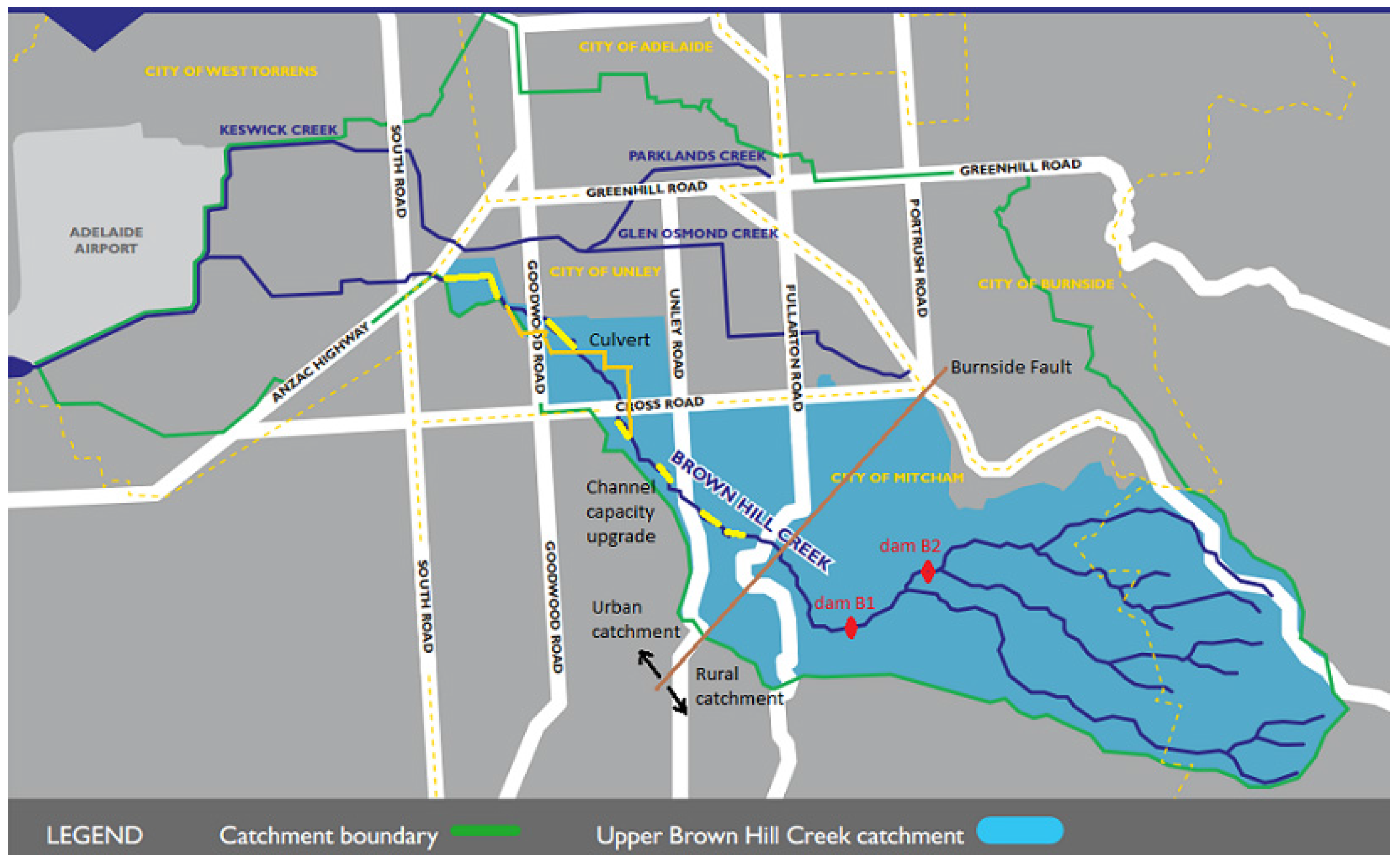
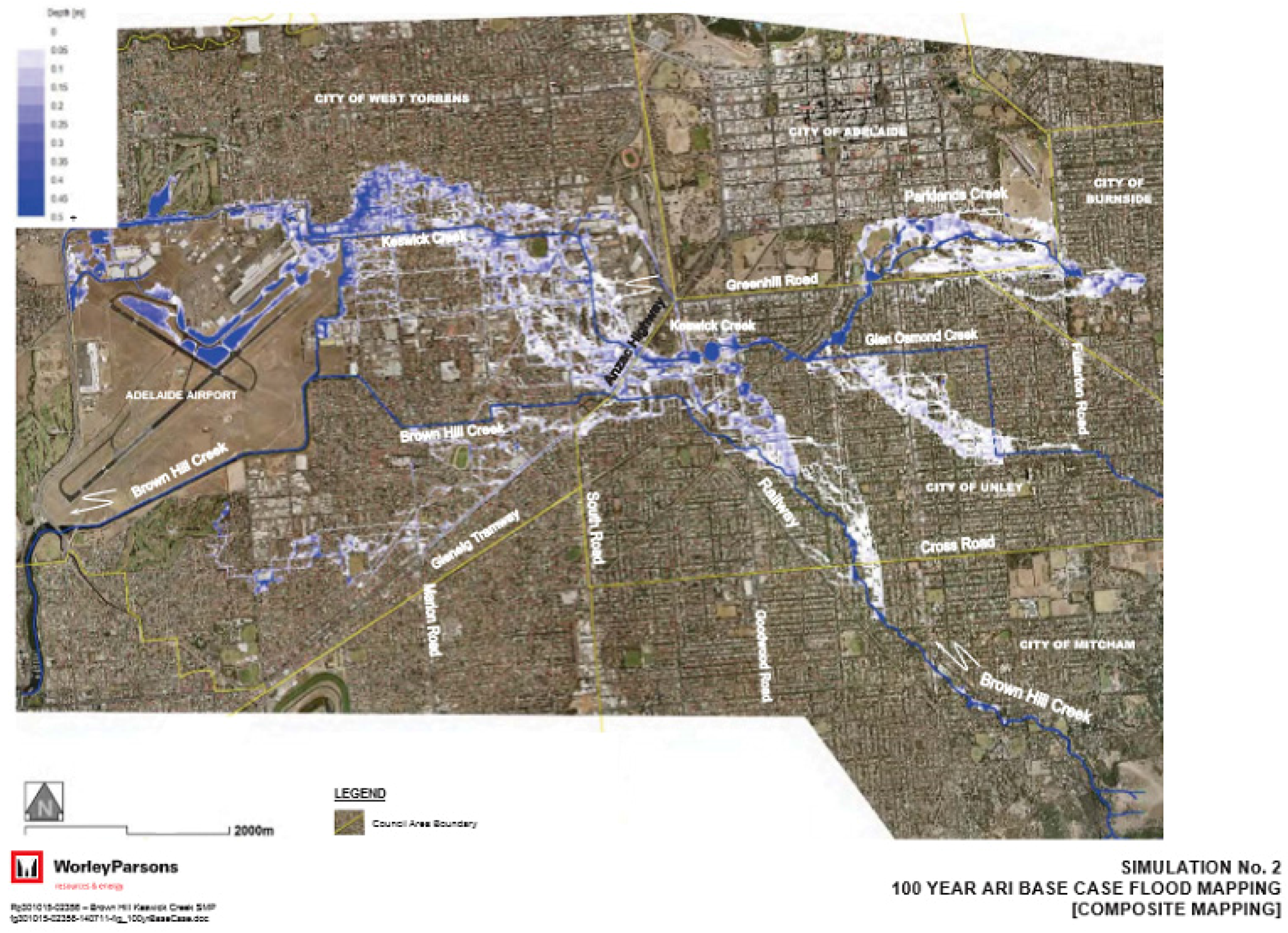
2.2. Brownhill Creek Geography and Flood Risk

The Adelaide Metropolitan Area is on a coastal plain between the Mt Lofty Ranges and the Gulf of St Vincent. It is traversed by three rivers, each of which has a water supply dam upstream that assists in mitigating floods from the upper rural catchment. Each river also has a linear park along its course through the urban area to act as a major recreational amenity, support natural habitat and to serve as a flood drainage channel to mitigate flooding from the urban catchment. The city also has 25 creeks and drains in the urban area but only four are considered to have a high risk of major floods, Brownhill Creek, Cobbler Creek, Dry Creek and Pedlar Creek. Of these, Brownhill Creek presents the most significant risk, as there is no flood control dam in its upper catchment, and councils have allowed residential development over its flood plain, and even over the channel itself. As recently as 2015, several meters depth of fill has been spread on the flood plain close to the edge of the creek channel and houses built with floor levels above flood level, substantially reducing the flow capacity of the river floodplain. Brownhill Creek and its smaller neighboring Keswick Creek, which meet near Adelaide airport, are largely canalized and used as the main stormwater drains by these councils, severely compromising the ecological value of the creek downstream. Where the natural channel has been retained it has been scoured by increasing peak flows due to urbanization. The urban catchment area has been marked for urban consolidation under the metropolitan area development plan, but the rural catchment is part of the hills face zone and new development there is prohibited, reflecting the value placed on the natural bushland visible from much of the city. It was clear that a stormwater management plan was needed, and that all councils would need to take responsibility to prevent excessive flooding in the downstream council areas, shown for a composite map of 100-year average return interval floods (Figure 1). Brownhill Creek flows from the south east through the Cities of Mitcham and Unley to the City of West Torrens in the west before discharging into the Gulf of St Vincent to the west of Figure 1. Keswick Creek flows from City of Unley in the east and is joined by a northern tributary passing through the Cities of Burnside and Adelaide before connecting with Brownhill Creek just east of the airport in the City of West Torrens.

3. Brownhill Creek Consultation Case Study—Materials and Methods

3.1. First Consultation—Hydrological Aspects

The 100-year average return interval (ARI) flood was considered based on then-available Bureau of Meteorology (BOM) intensity-frequency-duration curves for 1.5, 6 and 36 h duration events and composite damage calculated [1]. Modelling showed that a flood mitigation dam would have no impact on flooding from short duration storm events that could produce localized flash flooding and stream bank overflow in the urban area but could reduce damage for the longer duration events. The evaluation averaged the damage from these three different duration events, as though they represented the full spectrum of 100-year ARI events. The expected downstream flooding in all events was found to be highly dependent on modelled channel capacity. The channel capacity data used in the initial flood modelling was 20 years old, and the channel had since become choked in places with exotic trees and debris. Furthermore, the BOM were in the process of releasing revised 100-year ARI rainfall data for use in all Australian flood studies.

3.2. First Consultation—Human Dimensions

The first public consultation program from 31 October to 12 December 2011 was to inform stakeholders and the community on the draft plan, and receive, collate and summarize feedback [3]. Materials were prepared to summarise the draft plan, including a summary report, brochure and fact sheets. A feedback form was mailed directly to 26,539 property owners and occupiers across the catchment, skewed towards the lower catchment where most potentially flood affected properties were located. Three open days were held in different council areas within the catchment and attracted 160 attendees. Although the draft plan relied on channel capacity expansion as the primary flood mitigating measure downstream, the only option given for flood management in the upstream part of Brownhill Creek was a dam. Effectively, the choice presented to residents was to have a dam or bear the risk of being flooded.
There was widespread community outrage in the City of Mitcham concerning the proposed dam in the Brownhill Creek Recreation Park and lack of consideration of alternatives by those responsible for the draft plan made evident in the consultation process. A group of concerned residents formed the No Dam in Brownhill Creek Community Action Group that subsequently became a subcommittee of Brownhill Creek Association. This group also pointed out that the environmental and social costs and benefits had not been included in the analysis, that the plan was in breach of the State Government’s own plans for the Adelaide metropolitan area, and that it failed to address the Natural Resources Management Board’s stated goals for improved urban coastal water. A petition was established, signs erected, brochures printed and distributed, a web site established to house factual information and to serve as a blog, a flagged rope slung across the creek at the elevation of the proposed dam crest to be a visual sign of the scale and impact of a dam at the project’s preferred site, heritage status determined for significant trees at the proposed dam site, and consultations held that led to messages of support from Kaurna (custodial aboriginal) representatives, conservation and heritage groups, and the local council and local members of State and Commonwealth parliaments. The City of Mitcham requested that supplementary technical studies be undertaken on the basis of revised information and lack of evaluation of alternatives to a dam such as enlarging channel capacity in the upstream urban area or use of culverts to bypass constricted sections in this area.

3.3. Second Consultation—Hydrological Aspects

Following community dissent during the first public consultation phase, the plan was divided into two parts. The Keswick Creek Catchment and Lower Brownhill Creek Catchment work plan (about 80% of total budgeted costs) was agreed to by all five councils who were the stakeholders in the project, but, for the Upper Brownhill Creek Catchment, new investigations were commissioned to:
  • use recently revised Bureau of Meteorology flood frequency-duration-intensity curves,
  • re-survey the creek channel hydraulic capacity and status,
  • evaluate culvert options to allow bypass flows in constricted sections,
  • estimate the size and cost of expanding channel capacity (including land acquisition and easement costs) and also in making good overgrown sections of channel,
  • consider locating the dam further upstream in a tributary, Ellisons Gully,
  • remodel flood hydrographs and damage estimates for the three design storms for all Upper Creek intervention options assuming that the Lower Creek interventions were in place, and
  • present the results to the constituent Councils and catchment community in a report and undertake a public consultation survey on a revised plan in Upper Brownhill Creek.
The councils, having recognised community opposition to a dam in the upper reaches of Brown Hill Creek, formed a preference to pursue a feasible and whole of catchment community supported “no dam” solution [2]. The subsequent revised plan [4] (BHKC, September 2014), which still did not evaluate water quality nor environmental externalities, found that a channel upgrade involving creek rehabilitation works and limited creek widening (not evaluated in the previous study), had the same flood mitigation benefits and was more than $5 M cheaper than the dam option. Culvert options in this area were found to be more expensive and technically difficult. Figure 2 is a map of the catchment showing key options.

3.4. Second Consultation—Human Dimensions

The second community consultation process (May–June 2015) built on the previous consultation process, with direct contact with potentially affected property owners and ongoing liaison with community groups. However, unlike the first process, all community groups that favored or opposed various options were interviewed and invited to comment on the consultation process before it was formalized and undertaken. From a community perspective, this helped dismiss distrust and engender confidence in the impartiality of the process.
This public consultation phase included surveys direct mailed to creek-side owners and residents, with follow up letters inviting further contact. All other residents wanting to respond needed to contact the project office to request a survey form. Importantly, all community groups that favoured or opposed various options were invited to comment on the consultation process before it was formalised. Open days were also held in the two closest council areas, Mitcham and Unley, to allow residents to ask questions of technical staff working on the project. Information about forms and open days was placed in advertisements in a local newspaper that is delivered free to all households in the catchment. Consultants’ reports were made available as reference material via the web and at council offices. Creek side land owners were given written assurance that they would be consulted on the specific design options for achieving the required channel capacity on their land, and they would have the option of council maintaining that treatment at no cost to them or to maintain it themselves.
Contrasts between the two consultation approaches included the second process was much narrower in scope and more targeted, good dialogue with community action groups before the second survey to discuss and seek input to the process and the feedback form, greater control over feedback forms by requiring them to be issued in paper form only from the BHKC Project Office, and reporting separately on responses on the forms mailed to creek owners and forms received from the general community upon individual request. Overall, the improvement in process rigor and in openness with all interested members of the community helped to achieve results for the second survey that were unambiguous, and all members of the community could see that their main concerns had been recorded and were addressed impartially.
The different geographic scale of the two public consultation processes and contrasting proximity of impact of options on different segments of the community would suggest that a range of tools be used within a broader framework, as advocated by Dean et al. [5] and synthesized by Lacroix and Megdal [6] as a Stakeholder Engagement Wheel. Lacroix and Megdal also identified the need for additional forms of engagement with stakeholders who have expertise in the subject based on their professional or personal interest, and the meetings with action groups in the second consultation met those needs. On the IAP2 Spectrum of Public Participation (IAP2 2015) [7], the first consultation was at the level of “consult” (to obtain feedback) but had deficiencies in the objective of listening to and acknowledging concerns. While the second consultation remained at the “consult” level in seeking feedback on the 2015 report, it was at the next level “involve” in working with key community groups and potentially affected property owners to ensure concerns were considered and understood within the process, and was successful in ensuring community aspirations were directly reflected in the report. Further along the spectrum are “collaborate” and “empower” and collaboration is expected during the detailed design of channel capacity restoration, when creek-side householders will be given the opportunity for input into how the required objective can be achieved (see Table 1). Note that the opportunity for public engagement on non-structural measures, such as a flood preparedness program, or flood insurance was not taken up. Furthermore, other elements reasonably expected in a stormwater management plan, including water quality improvement, stormwater harvesting for beneficial uses, urban amenity and green space were also not pursued, as the councils had previously agreed to limit the scope of the plan.
During this second public consultation phase, the Brownhill Creek Association [8]:
  • updated its web site, Facebook and Twitter sites with the new information;
  • letterboxed two council areas encouraging community members to respond;
  • manned a booth at a shopping centre to spread the message and extend the petition;
  • sent letters to the editors of local newspapers and were represented on radio and television;
  • placed advertisements in local newspapers and sent out press releases;
  • gained further statements of support from relevant credentialed aboriginal heritage and environmental conservation organisations;
  • arranged expert evaluation of stone pines at the primary dam site which revealed they were Australia’s largest specimens and were subsequently recorded on a national register of trees of significance;
  • publicly displayed numerous banners and signs;
  • made deputations to councils involved and lobbied for support;
  • addressed community groups and visitors to the Brownhill Creek Recreation Park;
  • conducted a heritage walk along the upper creek through Ellisons Gully;
  • produced and circulated a children’s book about yabbies in the creek; and
  • produced two YouTube videos on children playing in Brownhill Creek.

4. Results

4.1. Outcome of First Community Consultation

A total of 2278 feedback forms were received, 8% of all those distributed [3] (Table 2). Response rates ranged from 5% in West Torrens (downstream) to 52% in Mitcham (upstream). The Consultation report [3] found strong support for all elements of the plan (at 71% overall) except for the dam in Brownhill Creek.
The report stated that the flood control dam at Brownhill Creek Recreation Park was the least supported component of the Draft Plan overall with 33% of respondents opposed to a dam and 57% supporting a dam (Table 2). However, there was a large variation in level of support among council areas, ranging from 7% opposed downstream in West Torrens where residents had been led to believe that the dam was essential to prevent flooding there, to 74% and 76% opposed in Mitcham and Adelaide in closer proximity to the recreation park (Table 3). Hence, the extreme bias in distribution of mailed out feedback forms (Table 2) significantly inflated the reported aggregated support for the dam. Although reported, no weight was given to the petition against the dam signed by more than 4000 at that time (and subsequently closed in May 2015 with 11,617 signatures).
The first public consultation report [3] summarized some of the objections raised at meetings with Friends of Brownhill Creek and residents living in close proximity to the proposed dam. A fuller description of these concerns not reported include impacts on stream ecology and water quality during and after dam construction, the extent of loss of recreational amenity, and specific impacts on local residents including noise, dust, quarrying and heavy haulage equipment on a small road which were an issue for local residents.
The plan also failed to meet the NRMB’s stormwater management planning criteria [10], in addressing flooding to the exclusion of all other environmental and water resources considerations as specified in various SA Government plans (AMLRNRMB (2008)-integrated NRM Plan for Adelaide, now updated 2014-15 to 2023-24 [11] and Mt Lofty Ranges, Dept. Planning and Local Government (2010)-urban plan for Adelaide [12], Department for Water (2011)-stormwater management strategy [13] and Environment Protection Authority (2011)-coastal water quality improvement [14]. A full report of departures from these plans is found in public consultation submissions by BCA [15] but no mention is made in any of the BHKC reports.
The outcome of this consultation was that the Brown Hill Keswick Creek Project recommended and the five Councils agreed to proceed with the lower catchment flood management measures, and to undertake additional investigations to determine options for the upper catchment and undertake a separate community consultation based on recommendations arising from these studies.

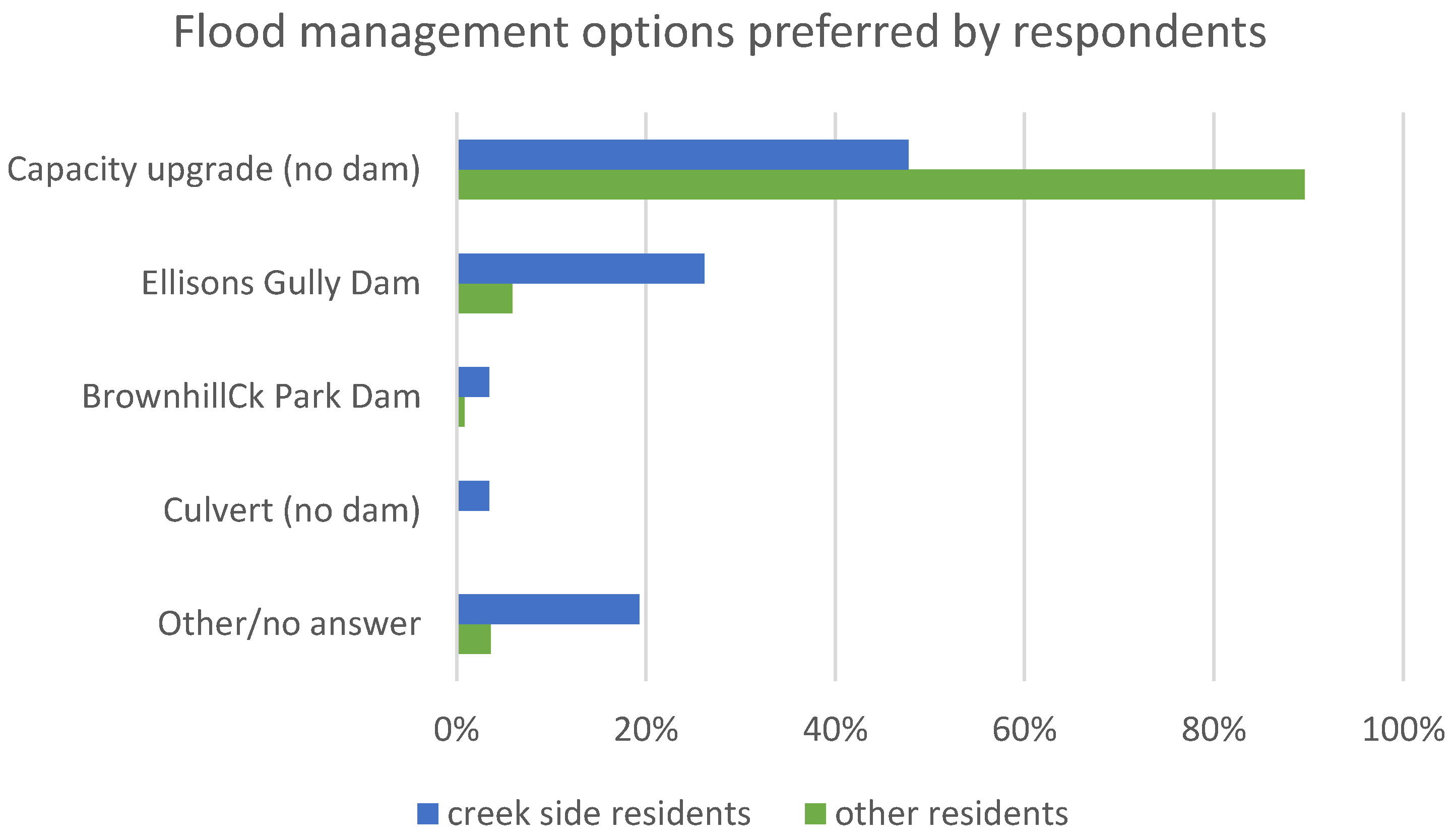
4.2. Outcome of Second Community Consultation

Following the consultation process, a report was provided by the consultant [9], which revealed the breadth of views on the options for the upper creek management plan. Among Creekside land owners, there was a low rate of response, particularly in Unley where the most outspoken critics of the recommended option of channel rehabilitation (no dam) resided (Table 2). In spite of average easements being 240 sq. m. per property, 69% of residents in Unley and 46% in Mitcham had ignored appeals by the Project Office to respond to the feedback form. As outlined in the report, creek-side owners and residents were contacted by letter on several occasions, invited to attend meetings and encouraged to respond to the consultation process questionnaire because it was reasonable to assume that the proposed flood mitigation works were of more relevance to them than the rest of the community. It is possible that assurance by the project office that consultation would occur with individual land-owners on channel works was sufficient to satisfy non-responding land-owners. Photographs of example channel modifications that were provided in public consultation documents were aesthetically attractive and would be safer than existing steep and eroding banks and may have alleviated concerns.
In contrast, 89% of all responses came from members of the public who were not creek-side residents, and felt strongly enough on the issue that they requested and completed forms. The Brownhill Creek Association had also appealed to residents through a letterbox drop to all Mitcham residents and a stall in the Mitcham shopping centre to encourage them to request forms. Many who told stall volunteers that they would request forms were parents of young children, and middle-aged and elderly people who walked in the park regularly or who had in earlier years. They frequently mentioned their desire to preserve its natural beauty, particularly with urban consolidation and the park was so close to the city but hidden from it.
Results were convincing: 50% of respondents from creek-side properties who expressed support of any option supported the no dam option (Figure 3). The next highest level of support by creek-side owners was 26% in favor of a dam in Ellisons Gully. Thus, it is clear even among creek-side property owners alone, the strongest preference was for the channel rehabilitation with no dam. For all other respondents, the support was 90% for channel rehabilitation with no dam and 6% for a dam in Ellisons Gully. In aggregate, the no dam option had 85% support. In addition to the feedback form, individuals and organisations were invited to make written submissions to the Project Office concerning the Stormwater Management Plan. In total 76 submissions were received with 80% supporting the no dam option (Table 4). With this very clear outcome in favour of the no dam option, the five councils were informed and requested to support the proposal by 30 September 2015.
Four councils passed the motion to proceed with the no dam option including appropriate consultation with affected property owners concerning treatments to achieve the channel capacity at their location, and giving the option for easements (councils to maintain) or agreements (individual to maintain). In all cases, the motion was passed unanimously or with a significant majority. Unley Council could not reach agreement and called a special meeting to address the issue on 29 September. After several motions were lost, the original motion succeeded with some minor amendments, including that account be taken of initiatives to improve water quality and harvesting. The Project Office reported the agreement of the five councils on the preferred option to the Stormwater Management Authority for finalization of the plan (based on the no dam option) and its approval by the State Government. The plan was finalized in March 2016 (BHKC 2016) and submitted to SMA.

5. Discussion

5.1. State and Local Government Interaction

Aside from covering the cost of an updated channel capacity assessment, there was minimal conspicuous participation from the NRMB. NRMB had expressed a desire not to interfere in local matters that were the subject of public consultation. However, the Stormwater Management Plan that was produced failed the planning criteria set within the NRMB’s own catchment plans by focussing only on flood mitigation (and within this using only structural means). A second reason why NRMB or its parent, Department of Environment Water and Natural Resources, may have been expected to comment was on the potential loss of native vegetation, biodiversity and recreational amenity through the proposed construction of a dam midway along the 5 km long, 100 m wide Brownhill Creek Recreation Park. It was perceived by the community that the NRMB’s lack of leadership in executing its own responsibilities was more related to deferring or potentially avoiding costs for state government rather than an unwillingness to play an active role while solutions for flood mitigation were being openly debated. State government also failed to intervene when one or more councils prevented the channel widening option from being included in the first public consultation exercise. This was in denial of the National Water Initiative to which all States are signatories that explicitly demands all water management options to be on the table and considered on their merits.
The councils also had a desire to reduce or defer costs. Unfortunately, councils had not been maintaining the channel capacity of the creek, nor had the NRMB required creek-side householders to do so. Hence, in the period since the CWMB flood study, channel capacity, particularly in the urban upstream area had in some places been halved by woody weeds including ash, elm and willow. Remarkably, none of the councils recognized the flood plain to be part of the stream, and there are many examples of fill being brought in and new houses established in the flood plain right up to and even over the main channel of the creek. Councils could see that should these need to be addressed they could accrue some liability for these blockages. No council was actively advocating the purchase of creek-side land as it came onto the market, nor a plan to prevent further creek-side development and fairly compensate owners for compulsory acquisition whenever the incumbent sought to change ownership. There are excellent local examples of linear parks along streams in urban areas, such as the Torrens and Little Para Rivers, concurrently serving recreation, wildlife habitat, urban green space, water quality improvement and flood mitigation needs while also providing increased opportunity for groundwater recharge and beneficial reuse. A larger scale example of flood management is in the Murray-Darling Basin where a wide diversity of water issues are addressed in a constraints-management-strategy [16], which enables creative use of water storage infrastructure to encourage minor flooding for the health of riverine and riparian ecosystems and mitigate against damage-causing major floods in a predominantly rural catchment.

5.2. Interactions among Councils

Initially, in response to the draft 2011 Stormwater Management Plan, the five councils were divided with four voting in favor of the plan presented. The most upstream council, the City of Mitcham dissented, objecting to a dam in Brownhill Creek and requesting that other options be explored. The Mayor of the most downstream council, the City of West Torrens, the council with the largest number of houses within the 100-year flood-prone area, was quoted in community newspapers as saying that wealthy (liberal-voting) Mitcham residents were holding a small part of the environment to be more precious than thousands of his middle-class (labor-voting) constituency who would inevitably be flooded without a dam. After the councils agreed to split the plan into upper and lower creek plans, the lower creek plan was unanimously supported by councils, and West Torrens made no further comment on upstream options that led to cost-effective achievement of satisfactory flood mitigation.
Conflict then ensued between Cities of Mitcham and its neighbor Unley, as to which of three options to pursue. These were:
  • a dam in either the Brownhill Creek Recreation Park or on a tributary in Ellisons Gully further upstream;
  • diversion culverts and pipes around constricted sections of creek; or
  • widening of the creek channel (upgrading capacity) at critical sections.
In addition, for all options there was a requirement to also rehabilitate the capacity of the natural channel where it had been overgrown by exotic trees and reduced by unauthorized structures, at the expense of the Project. Creekside land owners were to be given the option of having an easement on their property title which would give council the right and responsibility for future maintenance of the channel capacity, or committing to maintain capacity at their own expense.

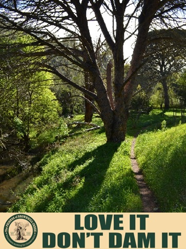
5.3. Local Action Groups

Three local action groups seized on different positions with respect to each of these options (Table 5):
  • No dams action group of Brownhill Creek Association (BCA)—to oppose dams at both prospective sites, aimed at improving environmental and community outcomes at least cost;
  • Save Our Streets Community Action Group (SOSCAG)—to protect street trees whose health and survival could be threatened by construction of major culverts under streets in Unley and Mitcham;
  • Save our Creek Environs Trees (SOCKET)—to protect rights and autonomy of creek-side land owners or maximize compensation if easements are imposed.
These three groups continued public campaigns, with the latter two primarily with councils of the Cities of Mitcham and Unley, with creek-side residents and in community newspapers. SOCKET threatened legal action as it considered that the $3.2 M set aside in the budget for easements to be too low by an order of magnitude. If their desired allocation for easements was used the dam would then become the cheapest option. It was noted that the number of action group titles increased as the public consultation program progressed, in part due to the impression that each perceived separate group allowed a separate voice to be heard and could increase influence on the outcome.

6. Corollary

The unanimous agreement of the five councils to the no dam option has paved the way for a detailed flood management plan and cost sharing arrangements between the State and local government. The attention of the Brownhill Creek Association has refocused on restoring native riparian vegetation, removal of weeds, and expanding bushwalking and heritage trails connected to the walks already present through the Brownhill Creek Recreation Park. It is also actively facilitating environmental education opportunities and creek amenity enhancements and biofiltration of stormwater associated with a carpark expansion at a shopping centre built over the creek. Further work is planned on informing planning regulations for creek-side development, informing environmental flow requirements, informing improved stormwater management policies and practices including funding mechanisms for water quality improvement and improved amenity and stormwater harvesting via managed aquifer recharge, and exploring non-structural measures for flood damage mitigation, through for example the FloodSafe Program [17] for flood preparedness, while awaiting completion of structural measures. In December 2015, two members of BCA, David Wagner and Ron Bellchambers, received awards from the SA Conservation Council recognizing their role in environmental protection and Ron Bellchambers was awarded the Mitcham Citizen of the Year in January 2016.

7. Conclusions

Key messages from the Brownhill Creek Association to those engaging with the community on new water management projects are:
  • Engage with the community early while draft plans and options are flexible and expandable, well before reaching a formal public consultation phase.
  • Do your homework and ensure that data, which could change priorities of options, is correct before engaging in modelling work. Do sensitivity analyses on all assumptions that have potential to change the preferred option.
  • Consider the full range of costs and benefits for each option and quantify or at least rank the impact of options on environmental and social externalities.
  • Put all options on the table. Do not omit obvious solutions because of fear that they will be unpalatable with influential parties.
  • Where options depart from existing soundly based policies and strategies that have developed with effective consultation, there should be a clear rationale for the departure and the consequences for the achievement of the objectives of those policies.
  • Ensure those that may be affected have a clear understanding of how and how much they may be affected, and how this may be mitigated.
  • Do not dismiss people’s opinions because they have a different perspective from those of the project proponents or consultants. There are many dimensions to problems and solutions and a consultant cannot be expected to know them all, but can reasonably be expected to listen and broaden their perspective, and improve investigations and recommendations.
  • The costs to a community to campaign for the ultimately most popular solution in this case amounted to more than $200,000 in in-kind labor as well as more than $10,000 in communications costs. Much of this could have been avoided by improved engagement with the community at an early stage. The costs to the community are generally neglected in decision making and achieving a suitable standard of rigor in investigations, and consulting the community in framing investigations could save on gross expenditure and speed up approval processes.
Participation in a community action group has revealed to the authors the anxiety and powerlessness experienced when factual information provided to officials is disregarded or at least not acknowledged because it is perceived to be selected to support a pre-determined position. The factual material posted on the action group’s web site was written or audited by two water resources professionals of full professor standing and reviewed by peers with standing in the specific disciplines involved. We attempted to present balanced and accurate information. This contrasted with the original Draft Plan based on flawed investigations, and the biased design of the first community consultation process. The group observed that a much higher standard of technical work was achieved for the second consultation, and the second community consultation process was not only better designed and executed, but very importantly, used an inclusive process that enabled trust to be restored.
There is still room for improvement in a plan that surveys a 100-year time horizon for flooding, but does not yet also consider on the same time scale a plan for urban amenity, green space, recreation, and gives only token attention to water quality improvement, and stormwater harvesting via managed aquifer recharge in a consolidating urban area [2]. It was beyond the ability of our action group to widen the scope of the stormwater management plan beyond structural measures for flood mitigation, but ultimately this is our long term goal.

Acknowledgments

The authors are grateful to Natalie Fuller and Associates for reviewing the draft manuscript, and to two anonymous reviewers of MDPI Water Journal for constructive comments on the manuscript.

Author Contributions

Peter Dillon produced several articles to identify benefits of alternatives to the dam, suggested documentation of the consultation process, produced a draft of the paper and undertook revisions. Ron Bellchambers devoted himself to liaising with and making deputations to councils and many organizations in securing support for assessment of alternative options and in running the web site, petition and public communications reported. Wayne Meyer chairs BHA is a Professor of Natural Resources Management and helped construct a cogent case and was the main media spokesperson for the later stages of the campaign. Rod Ellis organized community meetings at Mitcham Village Uniting Church, liaised with Friends of Brownhill Creek, and with Wayne and Ron contributed ideas and reviews of drafts.

Conflicts of Interest

The authors are members of Brownhill Creek Association, and have summarized this information to give a community perspective while maintaining scientific impartiality to the best of our knowledge. A draft manuscript was provided to the public engagement consultant for review and revised to account for their comments. This work has not been sponsored or funded.

Abbreviations

The following abbreviations are used in this manuscript:
AMLRNRMB
Adelaide and Mount Lofty Ranges Natural Resources Management Board
BCA
Brownhill Creek Association
BHKCSP
Brown Hill Keswick Creek Stormwater Project
BOM
Bureau of Meteorology

References

  1. Brown Hill Keswick Creek Stormwater Project. 2012. Available online: http://bhkcstormwater.com.au/ (accessed on 19 April 2016).
  2. Brown Hill Keswick Creek Stormwater Project. Brown Hill Keswick Creek Catchment Stormwater Management Plan 2016. 2016. Available online: http://bhkcstormwater.com.au/ (accessed on 19 April 2016).
  3. URPS in Association with Natalie Fuller and Associates Pty Ltd; Harlen Graphics. Brown Hill Keswick Creek Draft Stormwater Management Plan: Community Consultation Report; Prepared for the Brown Hill Keswick Creek Stormwater Project; 2012. http://bhkcstormwater.com.au/ (accessed on 19 April 2016).
  4. Brown Hill Keswick Creek Stormwater Project. 2014. Available online: http://bhkcstormwater.com.au/ (accessed on 19 April 2016).
  5. Dean, A.; Fielding, K.; Newton, F.; Ross, H. Community Engagement in the Water Sector: An Outcome-Focused Review of Different Engagement Approaches; Report Project A2.3; Cooperative Research Centre for Water Sensitive Cities: Clayton, Australia, 2016. [Google Scholar]
  6. Lacroix, K.M.; Megdal, S.B. Explore, Synthesize, and Repeat: Unraveling Complex Water Management Issues through the Stakeholder Engagement Wheel. Water 2016, 8. [Google Scholar] [CrossRef]
  7. IAP2 (The International Association for Public Participation). The IAP2 Public Participation Spectrum. 2015. Available online: http://www.iap2.org.au/resources/public-participation-spectrum (accessed on 19 April 2016).
  8. Brownhill Creek Association. 2015. Available online: www.brownhillcreek.org (accessed on 19 April 2016).
  9. Natalie Fuller; Associates Pty Ltd in Partnership with URPS. Consultation findings on the Brown Hill Keswick Creek Stormwater Project: Part B Report. Prepared for the Brown Hill Keswick Creek Stormwater Project. 2015. Available online: http://bhkcstormwater.com.au/ (accessed on 19 April 2016).
  10. South Australia; Natural Resources Management Council. State Natural Resources Management Plan 2012-17. Available online: http://www.environment.sa.gov.au/about-us/our-plans (accessed on 19 April 2016).
  11. South Australia; Adelaide and Mount Lofty Ranges Natural Resources Management Board. Creating a Sustainable Future: Adelaide and Mount Lofty Ranges Natural Resources Management Plan Volume 1 Strategic Plan 2014-15 to 2023-24. Available online: http://www.naturalresources.sa.gov.au/adelaidemtloftyranges/about-us/our-regions-plan (accessed on 19 April 2016).
  12. South Australia; Department of Planning and Local Government. The 30-Year Plan for Greater Adelaide. 2010. Available online: http://www.dpti.sa.gov.au/planning/30_year_plan (accessed on 19 April 2016). [Google Scholar]
  13. South Australia; Department for Water. Stormwater Strategy—The Future of Stormwater Management. 2011. Available online: http://www.environment.sa.gov.au/managing-natural-resources/water-use/water-resources/stormwater (accessed on 19 April 2016). [Google Scholar]
  14. South Australia; Environment Protection Authority. Adelaide Coastal Water Quality Improvement Plan. 2011. Available online: www.epa.sa.gov.au/files/477449_acwqip_final.pdf (accessed on 19 April 2016). [Google Scholar]
  15. Brownhill Creek Association. A stormwater plan that fails the planning criteria. 2012. Available online: http://brownhillck.org/submissions (accessed on 19 April 2016).
  16. Murray-Darling Basin Authority. Constraints Management Strategy 2013 to 2024. Commonwealth of Australia, 2013. Available online: http://www.mdba.gov.au/publications/mdba-reports/constraints-management-strategy (accessed on 19 April 2016). [Google Scholar]
  17. FloodSafe: Community FloodSafe Program in South Australia-Increasing Resilience in Urban Communities Facing Flood Risk. 2009. Available online: http://www.ses.sa.gov.au/site/community_safety/floodsafe.jsp (accessed on 19 April 2016).
Figure 1. Composite flood map for 100-year average return interval floods of 1.5, 6 and 36 h duration events in the absence of a stormwater management plan (from BHKC, 2016 [2]). Flood depths for shown overflows from Brownhill and Keswick Creeks range from the shallowest 0 to 5cm (shown as white) through to the deepest at 45 to 50cm (shown as the darkest blue). Parts of unshaded areas may also be flooded to shallow depths by lack of capacity in local drainage systems that discharge to these creeks.
Water 08 00170 g001
Figure 2. Map of Brownhill and Keswick Creek catchments showing council areas and locations of key options (adapted from BHKC 2016 [2]).
Water 08 00170 g002
Figure 3. Preferences for flood management options from respondents in community consultation 2015 for creek-side residents and for other residents (adapted from [9]).
Water 08 00170 g003
Table 1. The consultation programs for the Stormwater Plan development and implementation as determined by BHKC Project categorized in relation to the International Association for Public Participation (IAP2) spectrum of public engagement [8].
InformConsultInvolveCollaborateEmpower
Consultation on Plan 2011Options specified by BHKC project and feedback sought from community.
Consultation on Plan 2015Options specified by BHKC project and feedback sought from community.Action groups given opportunity to comment on consultation process.
Implementation of Plan (not currently considered: Opportunities for participation in non-structural measures (e.g., flood preparedness programs), and measures to meet objectives other than flood mitigation.)Channel capacity is specified by BHKC and designs to achieve this are developed and agreed with each riparian land holder, under either an easement or an agreement.(not currently considered: However there are opportunities for household stormwater maangement options beyond council requirements.)
Table 2. Response rate from different community sectors (adapted from [3] and [9]).
Connunity SectorNumber of Forms IssuedNumber of Responses ReceivedPercentage Responding Distribution Method and Follow-up
1st Community Consultation, 31 October 2011–12 December 2011
Owners of properties potentially affected by floods, creek-side owners, state govt. representatives and others determined by BHKC Project Office (criteria not specified) by council area…26,5392,2788%Direct mail to owner. Also community newspaper notice to advise that Feedback forms available from council web sites, from 3 open days in community centres. There was no differentiation in reporting by source of feedback form.
Mitcham 1,05553552%
Unley 6,15763810%
Burnside 2,290 90 4%
Adelaide   176 7342%
West Torrens16,861942 5%
Others 4010naAn unsolicited petition contained 4,010 signatures of residents opposed to a dam in Brownhill Creek was submitted by the No Dam in Brownhill Creek Action Group to the City of Mitcham and forwarded into the consultation process.
2nd Community Consultation, 13 May 2015–23 June 2015
Creek side property owners in Mitcham   90 4954%Direct mail to owner and followed up by a letter and phonecall
Creek side property owners in Unley  126 3931%Direct mail to owner and followed up by a letter and phonecall
All other residents1,07473068%Community newspaper notice to advise that forms are available on request. No follow up.
Total1,29081863%
Table 3. Respondents support in the first public consultation program for no dam or dam in upper Brownhill Creek (adapted from [3]).
Council AreaNumber of Respondents% Support No Dam% Support Dam% No Opinion
Mitcham  53574%22% 4%
Unley  63830%61% 9%
Burnside   9037%11%52%
Adelaide   7376%6%18%
West Torrens  9427%82%11%
Total 2,278
Weighted Mean100%33%57%10%
Unweighted Mean 45%36%19%
Unweighted Standard Deviation 27%30%17%
Table 4. Written submissions from the public during the second public consultation program 2015 (adapted from [9]).
Written SubmissionsNumber of Written SubmissionsSupporting Option D (No Dam)Opposing Option D (No Dam)Support or Opposition Not Stated
Mitcham residents2624 02
Unley residents13 7 51
Other residents2121 00
Interest groups13 6 70
Businesses 2 2 00
Members of South Australian parliament 1 1 00
Total7661123
% of submissions100%80%16%4%
Table 5. Membership of community action groups originated from different geographic locations that influenced their motivations. All groups attempted to influence the community and the Project Office with their preferred options.
Action GroupGeographic SpreadPrimary MotivationOther MotivationsPreferred Option
BCADispersed widely but mostly in Mitcham where creek ecosystem values highest and nearest to recreation park where dam had been proposedEnvironmental and heritage protection in recreation park and natural areas, Preserve recreational amenityImprove creek environment in urban area, minimizing costs to the community, establish a green corridor, stream water quality improvement, enhanced stormwater harvesting.D (selective channel widening with no dam)
SOSCAGPredominantly residents of Unley streets where culverts had been considered an optionProtect street trees from culvert construction, avoid inconvenience of protracted major earthworks on residential streetsPreservation of existing trees in urban creek line, minimizing costs to the community. Various including D (selective channel widening with no dam) and dam B2 (location in Ellisons Gully)
SOCKETMinority of residents owning creek-side properties in Mitcham and UnleyRetain control of their own land, fear of loss of land value, inconvenience and risks of earth works adjacent family home.Preservation of existing trees in urban creek line, maximizing compensation to affected streamside landholders. B2 dam (location in Ellisons Gully)
(BCA—Brownhill Creek Association; SOSCAG- Save Our Streets Community Action Group; SOCKET—Save our Creek Environs Trees)

