
A Multi-Scale Approach in Hydraulic Characterization of a Metamorphic Aquifer: What Can Be Inferred about the Groundwater Abstraction Possibilities

Abstract
:1. Introduction
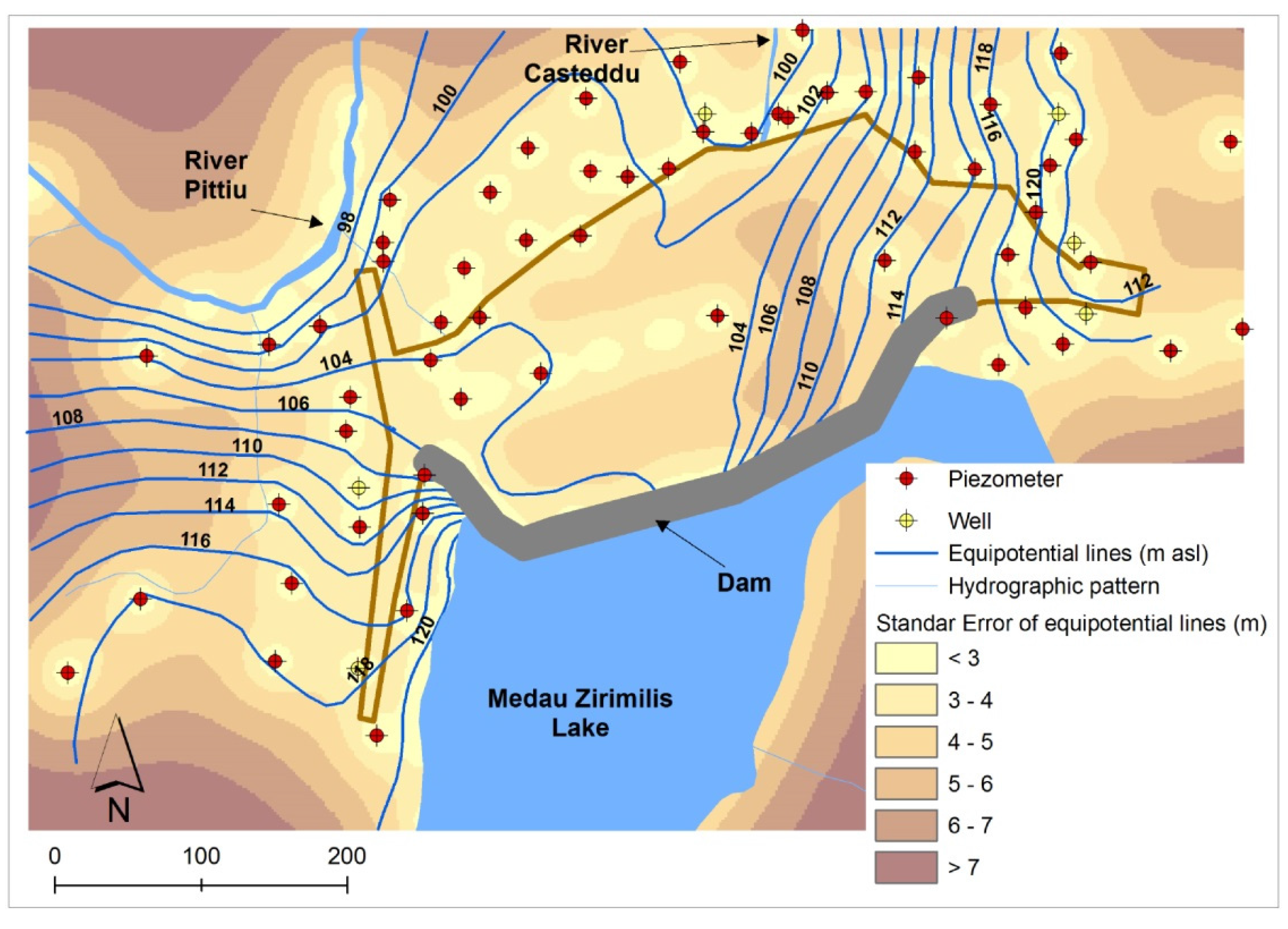
2. Study Area
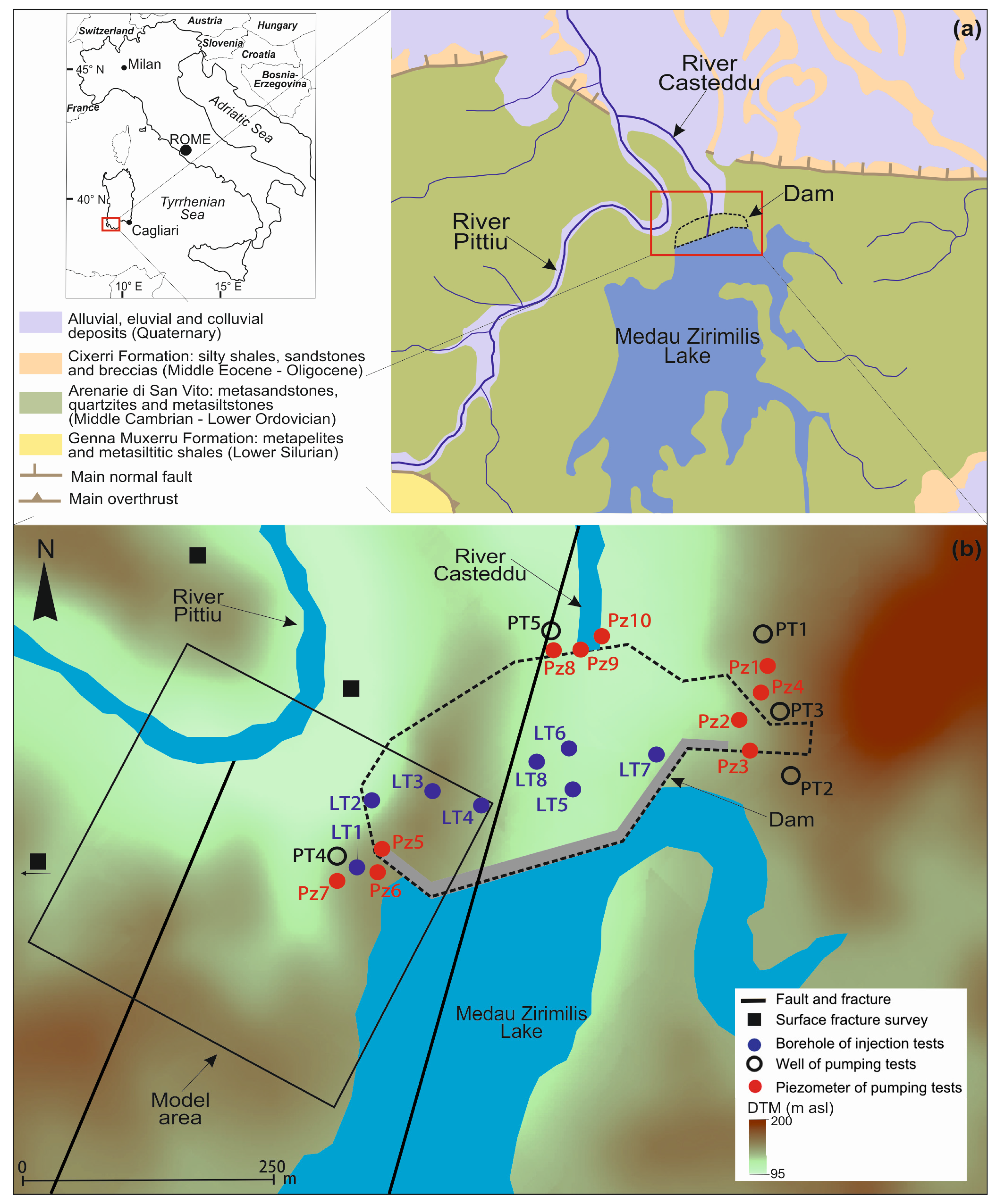
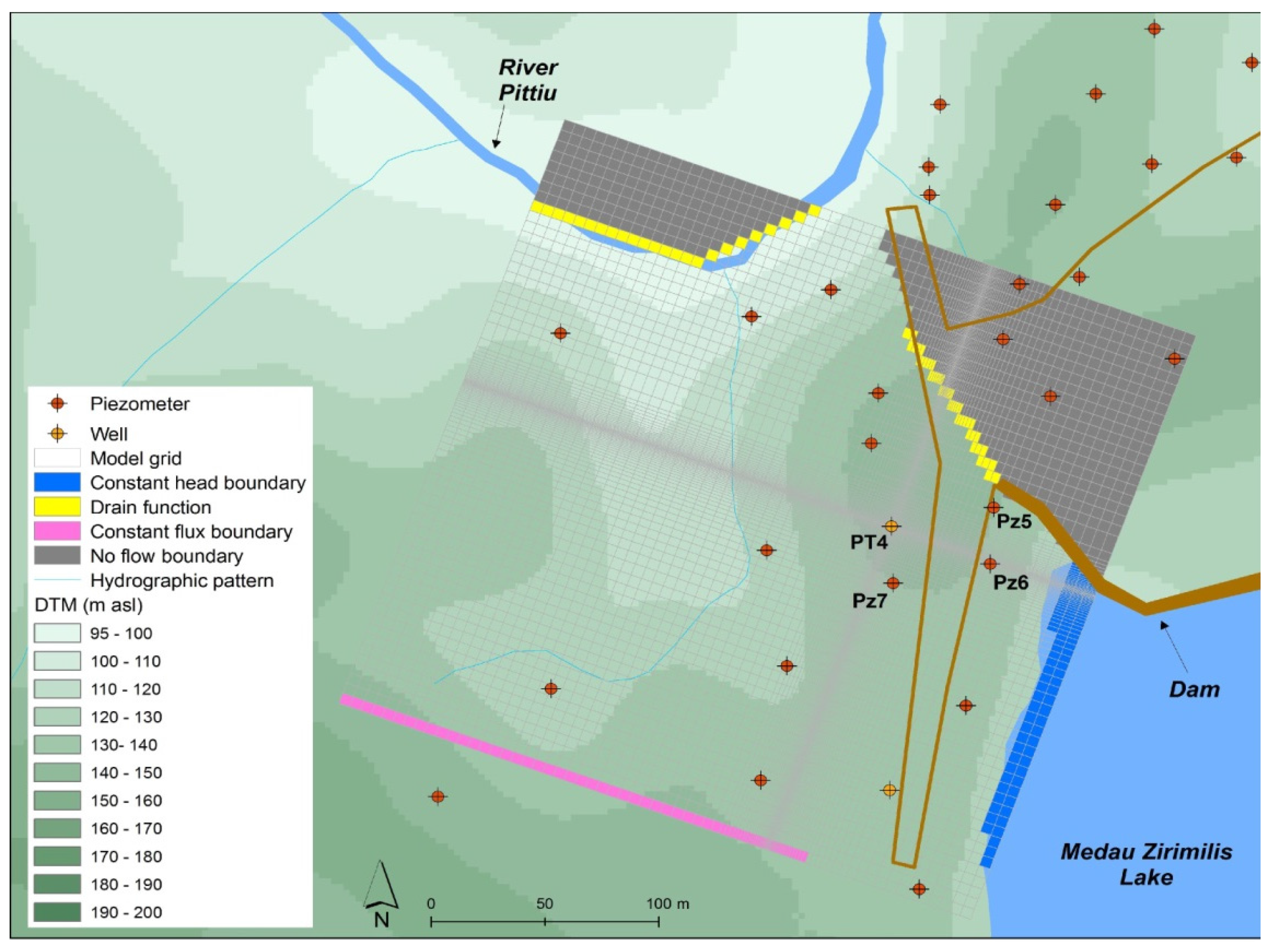
3. Investigations, Materials, and Methods
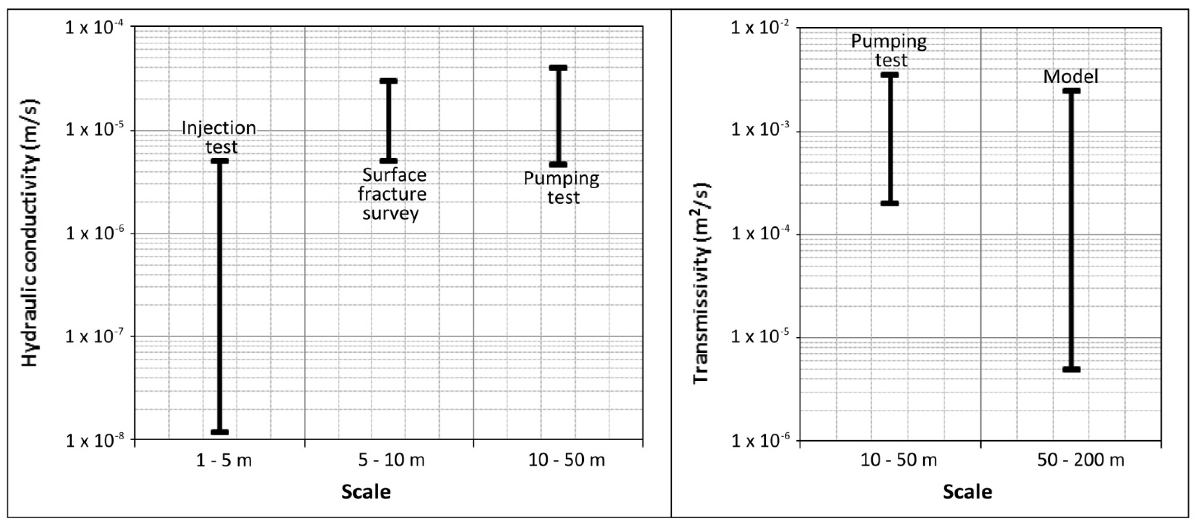
4. Results
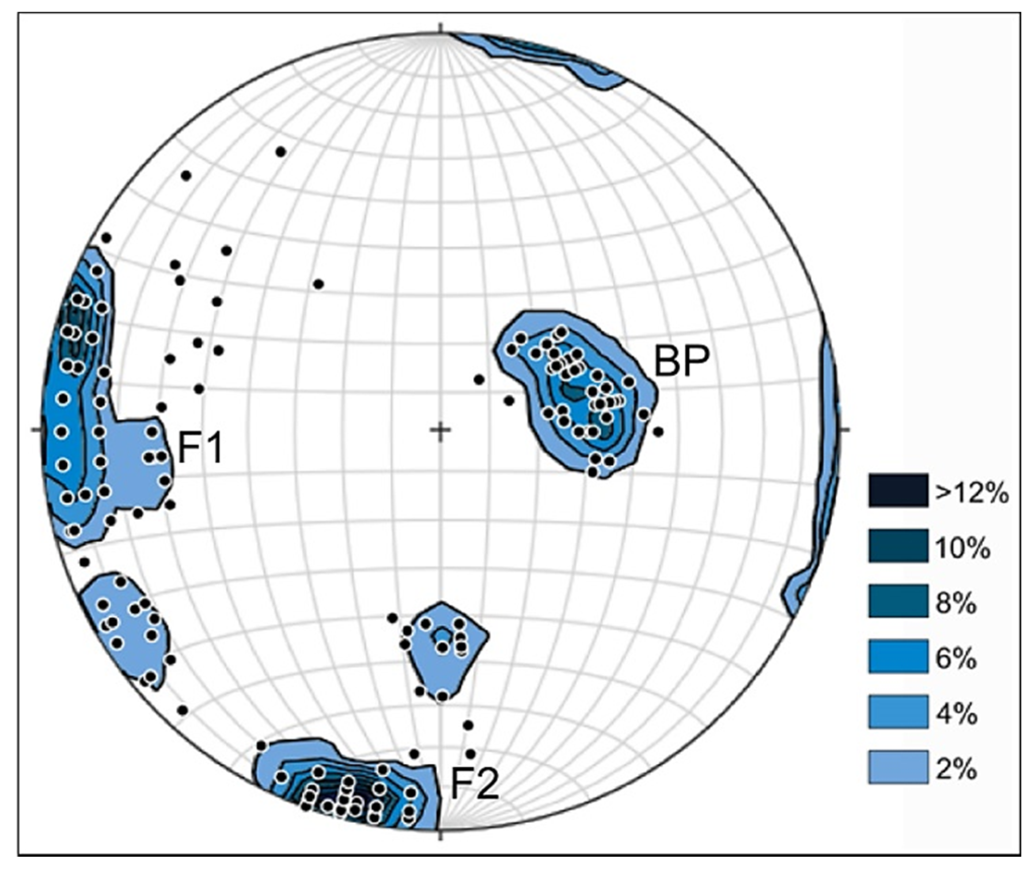
4.1. Discontinuity-Network Characterization


| Characteristic | Statistics | Set 1: BP | Set 2: F1 | Set 3: F2 |
|---|---|---|---|---|
| Orientation | Number of measurements | 48 | 96 | 68 |
| Mean dip direction (°) | 255.1 | 91.9 | 11.9 | |
| Mean dip angle (°) | 29.2 | 78.1 | 75.8 | |
| Fisher dispersion coefficient | 68.7 | 13.0 | 21.6 | |
| Spacing | Number of measurements | 64 | 74 | 133 |
| Mean (cm) | 26.20 | 24.45 | 10.47 | |
| Standard deviation (cm) | 1.77 | 2.01 | 1.38 | |
| Aperture | Number of measurements | 97 | 187 | 161 |
| Mean aperture (mm) | 0.12 | 0.15 | 0.15 | |
| Standard deviation (mm) | 0.19 | 0.26 | 0.21 |
| Set | k (m/s × 10−5) |
|---|---|
| Set 1: BP | 0.54 |
| Set 2: F1 | 1.13 |
| Set 3: F2 | 2.64 |
| Components | Value (m/s × 10−5) | Trend (°) | Plunge (°) |
|---|---|---|---|
| Minor | 1.58 | 201 | 15 |
| Intermediate | 3.19 | 109 | 6 |
| Major | 3.84 | 359 | 74 |
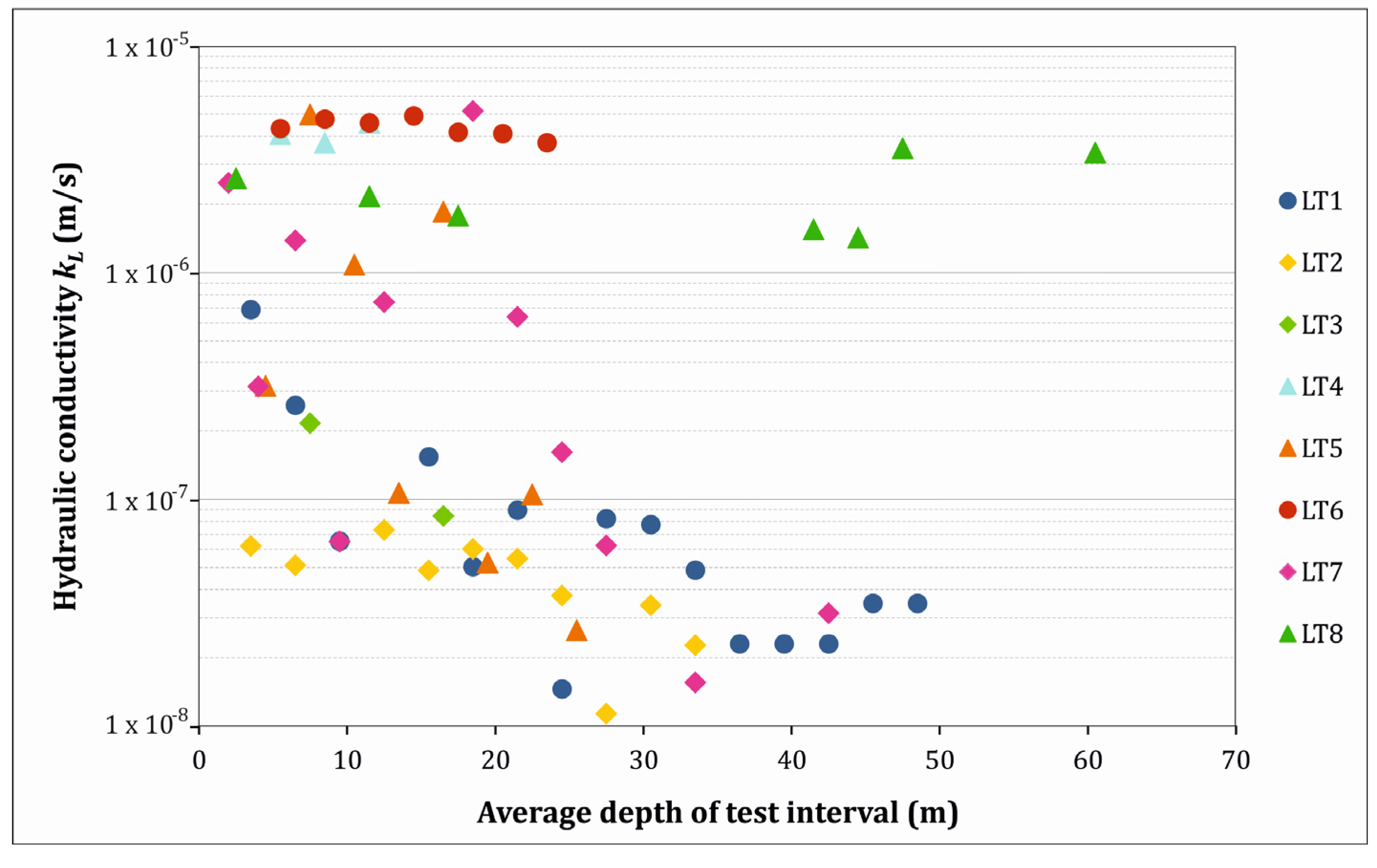
4.2. Injection Tests

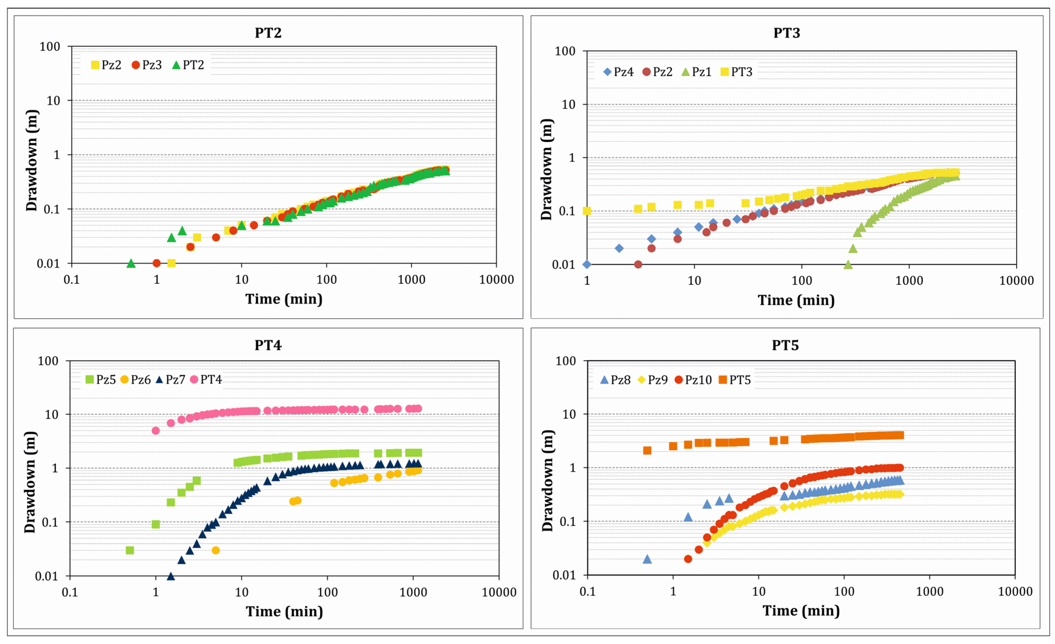
4.3. Pumping Tests

| Well | Q (m3/s) | Hsat (m) | Piezometer | T (m2/s) | KP (m/s) | S | RSS |
|---|---|---|---|---|---|---|---|
| PT1 | 2.1 × 10⁻³ | 50 | Pz1 | 4.89 × 10⁻⁴ | 9.78 × 10⁻⁶ | 2.61 × 10⁻² | 0.001 |
| PT2 | 2.3 × 10⁻³ | 41 | Pz2 | 1.44 × 10⁻³ | 3.51 × 10⁻⁵ | 1.85 × 10⁻³ | 0.024 |
| Pz3 | 1.42 × 10⁻³ | 3.46 × 10⁻⁵ | 5.11 × 10⁻³ | 0.024 | |||
| PT3 | 2.4 × 10⁻³ | 53 | Pz4 | 1.51 × 10⁻³ | 2.85 × 10⁻⁵ | 7.29 × 10⁻³ | 0.021 |
| Pz2 | 1.41 × 10⁻³ | 2.66 × 10⁻⁵ | 4.56 × 10⁻³ | 0.023 | |||
| Pz1 | 4.46 × 10⁻⁴ | 8.41 × 10⁻⁶ | 1.80 × 10⁻² | 0.002 | |||
| PT4 | 2.5 × 10⁻³ | 50 | Pz5 | 2.32 × 10⁻⁴ | 4.64 × 10⁻⁶ | 3.15 × 10⁻⁵ | 0.045 |
| Pz6 | 9.50 × 10⁻⁴ | 1.90 × 10⁻⁵ | 6.26 × 10⁻⁴ | 0.013 | |||
| Pz7 | 2.33 × 10⁻⁴ | 4.66 × 10⁻⁶ | 5.22 × 10⁻⁴ | 0.035 | |||
| PT5 | 3.5 × 10⁻³ | 86 | Pz8 | 3.57 × 10⁻³ | 4.15 × 10⁻⁵ | 9.92 × 10⁻⁴ | 0.023 |
| Pz9 | 3.44 × 10⁻³ | 4.00 × 10⁻⁵ | 8.83 × 10⁻⁴ | 0.001 | |||
| Pz10 | 8.24 × 10⁻⁴ | 9.58 × 10⁻⁶ | 2.64 × 10⁻⁴ | 0.002 |
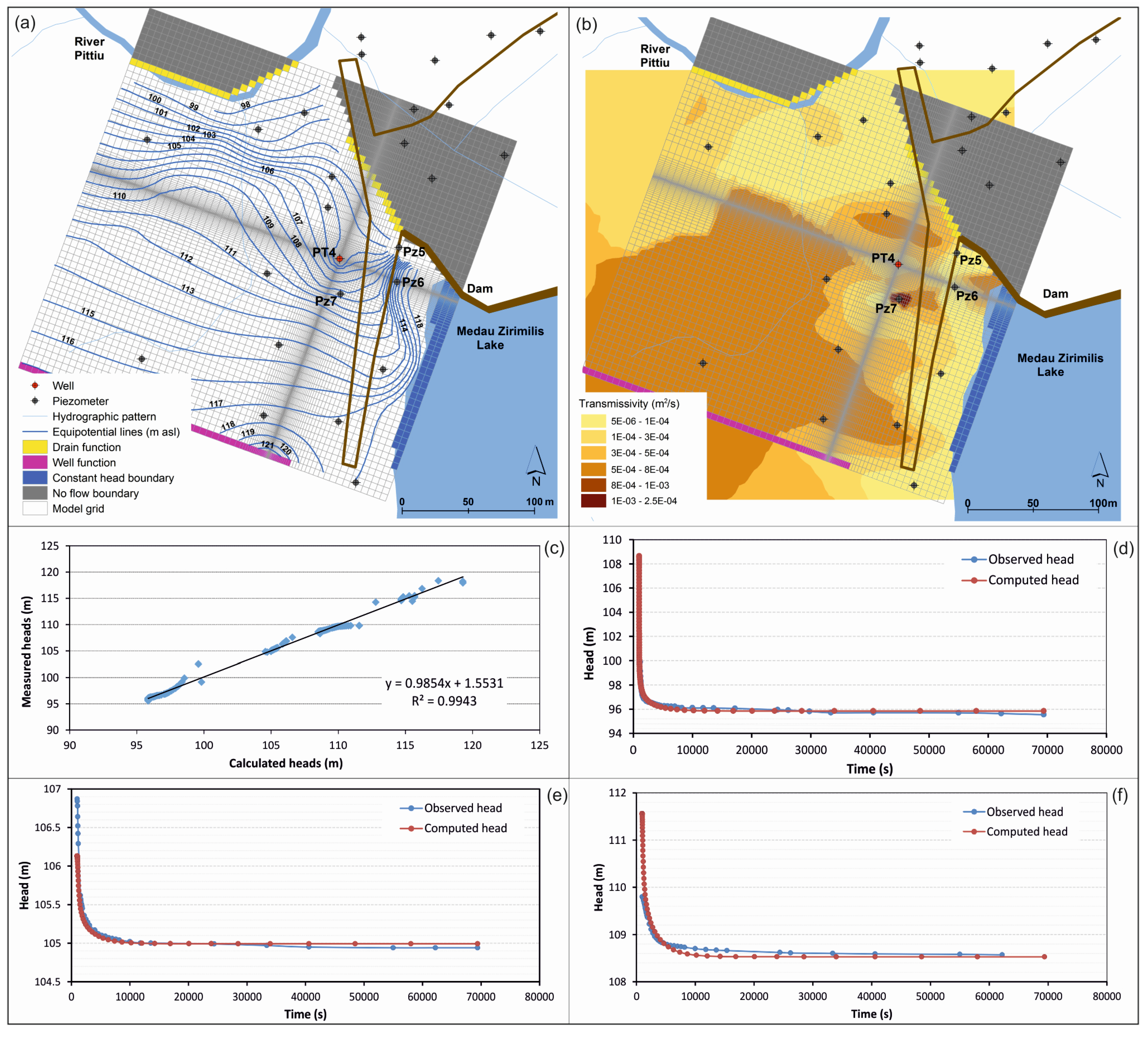
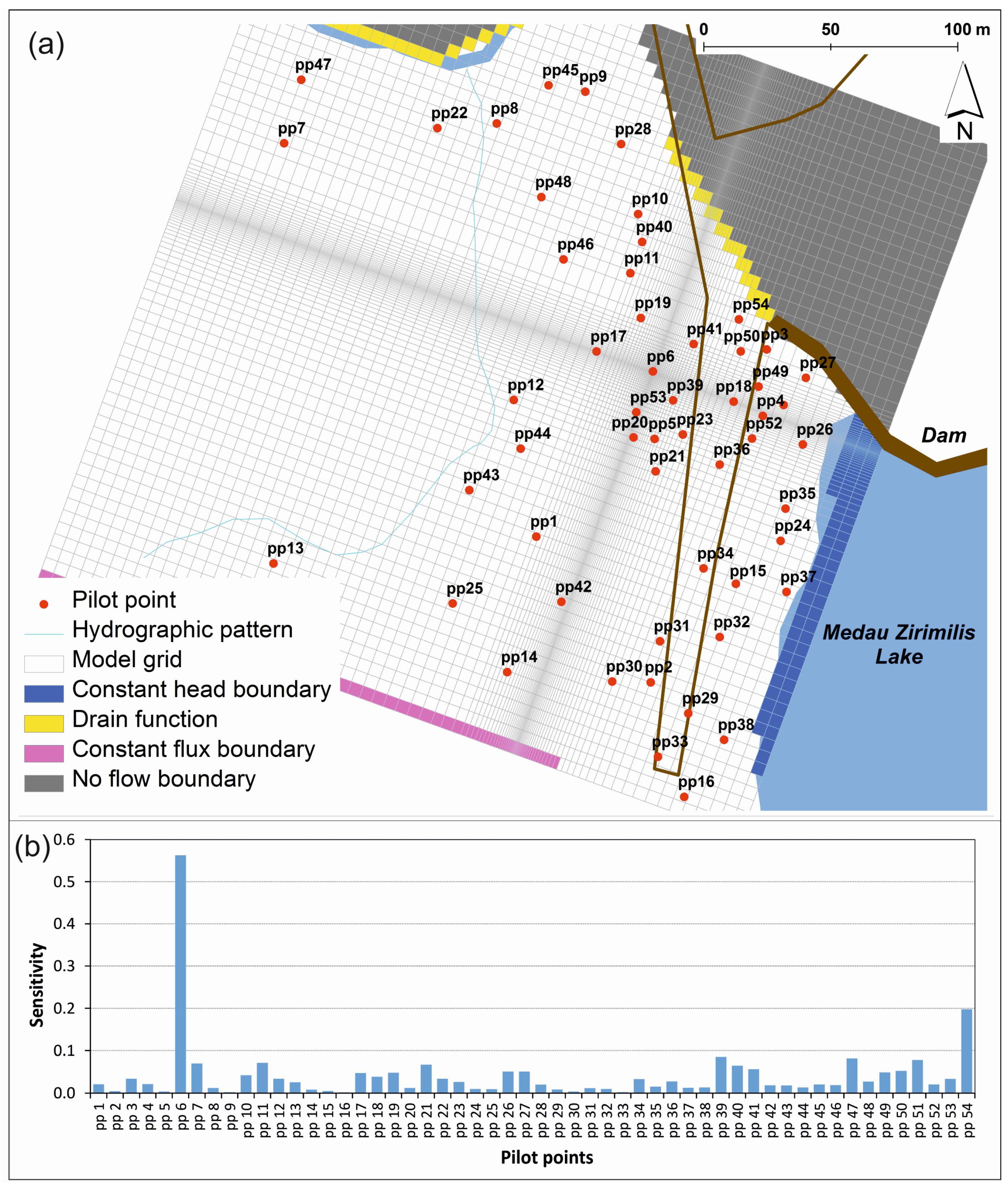
4.4. Groundwater Flow Model


| Model | Inflow ( × 10−3 m3/s) | Outflow ( × 10−3 m3/s) | % Error (in-out) | ||||
|---|---|---|---|---|---|---|---|
| Lateral Boundaries | Lake | Storage | Well | River | Lateral Boundaries | ||
| Numerical Model | 6.84 | 3.10 | 0.08 | 2.50 | 5.69 | 1.81 | 0.2 |
| Conceptual model | 4–8 | 4–5 | - | 2.50 | na | 3 | - |

5. Discussion

6. Conclusions
Acknowledgments
Author Contributions
Conflicts of Interest
References
- Banks, D.; Banks, S. Hydrogeology of Hard Rocks. In Proceedings of the Memoires of the 24th Congress, International Association of Hydrogeologists, Oslo, Norway, 28th June–2nd July 1993; volume 28, pp. 1–684.
- Stober, I.; Bucher, K. Hydrogeology of Crystalline Rocks; Kluwer Academic Publishers: Dordrecht, The Netherlands, 2003. [Google Scholar]
- Taylor, R.; Howard, K. A tectono-geomorphic model of the hydrogeology of deeply weathered crystalline rock: Evidence from Uganda. Hydrogeol. J. 2000, 8, 279–294. [Google Scholar] [CrossRef]
- Cho, M.; Ha, K.-M.; Choi, Y.-S.; Kee, W.-S.; Lachassagne, P.; Wyns, R. Relationship between the Permeability of Hard-Rock Aquifers and Their Weathered Cover Based on Geological and Hydrogeological Observation in South Korea. In Proceedings of the IAH Conference on “Groundwater in fractured rocks”, Prague, Czech, 15–19 September 2003.
- Dewandel, B.; Lachassagne, P.; Wyns, R.; Maréchal, J.C.; Krishnamurthy, N.S. A generalized 3-D geological and hydrogeological conceptual model of granite aquifers controller by single or multiphase weathering. J. Hydrol. 2006, 320, 260–284. [Google Scholar] [CrossRef]
- Krasny, J.; Sharp, J.M. Groundwater in Fractured Rocks; Taylor & Francis: London, UK, 2007. [Google Scholar]
- Foster, S. Hard-rock aquifers in tropical regions: Using science to inform development and management policy. Hydrogeol. J. 2012, 20, 659–672. [Google Scholar] [CrossRef]
- Sharp, J.M. Fractured Rock Hydrogeology; Taylor & Francis: London, UK, 2014. [Google Scholar]
- Uhl, V.W.; Sharma, G.K. Results of pumping tests in crystalline-rock aquifers. Ground Water 1978, 16, 192–203. [Google Scholar] [CrossRef]
- Howard, K.W.K.; Hughes, M.; Charlesworth, D.L.; Ngobi, G. Hydrogeologic evaluation of fracture permeability in crystalline basement aquifers of Uganda. Hydrogeol. J. 1992, 1, 55–65. [Google Scholar] [CrossRef]
- Chilton, P.J.; Foster, S.S.D. Hydrogeological characteristics and water-supply potential of basement aquifers in tropical Africa. Hydrogeol. J. 1995, 3, 3–49. [Google Scholar]
- Maréchal, J.C.; Dewandel, B.; Subrahmanyam, K. Use of hydraulic tests at different scales to characterize fracture network properties in the weathered-fractured layer of a hard rock aquifer. Water Resour. Res. 2004, 40. [Google Scholar] [CrossRef]
- Banks, D.; Gundersen, P.; Gustafson, G.; Makela, J.; Morland, G. Regional similarities in the distributions of well yield from crystalline rocks in Fennoscandia. Norges Geol. Unders. Bull. 2010, 450, 33–47. [Google Scholar]
- Lee, C.H.; Chang, J.L.; Deng, B.W. A continuum approach for estimating permeability in naturally fractured rocks. Eng. Geol. 1995, 39, 71–85. [Google Scholar] [CrossRef]
- Scanlon, B.R.; Mace, R.E.; Barrett, M.E.; Smith, B. Can we simulate regional groundwater flow in a karst system using equivalent porous media models? Case study, Barton Springs Edwards aquifer, USA. J. Hydrol. 2003, 276, 135–158. [Google Scholar] [CrossRef]
- Lemieux, J-M.; Therrien, R.; Kirkwood, D. Small scale study of groundwater flow in a fractured carbonate-rock aquifer at the St-Eustache quarry, Québec, Canada. Hydrogeol. J. 2006, 14, 603–612. [Google Scholar]
- Long, J.C.S.; Remer, J.S.; Wilson, C.R.; Witherspoon, P.A. Porous media equivalents for networks of discontinuous fractures. Water Resour. Res. 1982, 18, 645–658. [Google Scholar] [CrossRef]
- Hsieh, P.A.; Neuman, S.P.; Stiles, G.K.; Simpson, E.S. Field determination of the three-dimensional hydraulic conductivity tensor of anisotropic media. 2 Methodology and application to fractured rocks. Water Resour. Res. 1985, 21, 1667–1676. [Google Scholar] [CrossRef]
- Neuman, S.P. Stochastic Continuum Representation of Fractured Rock Permeability as an Alternative to the Rev and Fracture Network Concepts. In Proceedings of the 28th US Symposium on Rock Mechanics, Tucson, AZ, USA, 29 June–1 July 1987; pp. 533–561.
- Bradbury, K.R.; Muldoon, M.A.; Zaporec, A.; Levy, J. Delineation of Wellhead Protection Areas in Fractured Rocks; US EPA Technical Guidance Document, EPA 570/9-91-009; EPA: Washington, DC, USA, 1991. [Google Scholar]
- Nuclear Regulatory Commission (NRC). Rock Fractures and Fluid Flow: Contemporary Understanding and Applications; National Academy Press: Washington, DC, USA, 1996. [Google Scholar]
- Neuman, S.P. Trends, prospects and challenge in quantifying flow and transport through fractured aquifer. Hydrogeol. J. 2005, 13, 124–147. [Google Scholar] [CrossRef]
- Baiocchi, A.; Dragoni, W.; Lotti, F.; Piscopo, V. Sustainable yield of fractured rock aquifers: The case of crystalline rocks of Serre Massif (Calabria, Southern Italy). In Fractured Rock Hydrogeology; Sharp, J.M., Ed.; Taylor & Francis Group: London, UK, 2014; pp. 79–97. [Google Scholar]
- Dragoni, W. Some considerations on climatic changes, water resources and water needs in the Italian region south of the 43° N. In Water, Environment and Society in Times of Climatic Change; Issar, A., Brown, N., Eds.; Kluwer Academic Publishers: Dordrecht, The Netherlands, 1998; pp. 241–271. [Google Scholar]
- Intergovernmental Panel on Climate Change (IPCC). Summary for Policymakers. In Climate Change 2013: The Physical Science Basis; Cambridge University Press: Cambridge, UK, 2013. [Google Scholar]
- Carmignani, L.; Cocozza, T.; Gandin, A.; Pertusati, P.C. Lineamenti della geologia dell’Iglesiente-Sulcis [Outlines of the geology of the Iglesiente-Sulcis Region]. In Guida alla Geologia del Paleozoico Sardo; Società Geologica Italiana, Guide Geologiche Regionali: Roma, Italy, 1982; pp. 65–77. [Google Scholar]
- Istituto Superiore per la Protezione e la Ricerca Ambientale (ISPRA). Notes to the Geological Map of Italy 1:50,000 “Sheet 566–Assemini”; Servizio Geologico d’Italia: Roma, Italy, 2009. (In Italy) [Google Scholar]
- Barca, S.; Cocozza, T.; del Rio, M.; Pittau Demelia, P. Discovery of lower Ordovician Acritarchs in the “Postgotlandiano” sequence of southwestern Sardinia (Italy): Age and tectonic implications. Boll. Soc. Geol. Ital. 1981, 100, 377–392. [Google Scholar]
- Carmignani, L.; Conti, P.; Barca, S.; Cerbai, N.; Eltrudis, A.; Funedda, A.; Oggiano, G.; Patta, E.D. Notes to the Geological Map of Italy 1:50,000 “Sheet 549–Muravera”; Servizio Geologico d’Italia: Roma, Italy, 2001. (In Italy) [Google Scholar]
- Celico, P.; Piscopo, V.; Berretta, G. Influence of a reservoir on groundwater flow in metamorphic rocks. Geol. Appl. Idrogeol. 1993, 28, 253–261. (In Italy) [Google Scholar]
- Kruseman, G.P.; de Ridder, N.A. Analysis and Evaluation of Pumping Test Data; ILRI Publication 47; International Institute for Land Reclamation and Improvement: Wageningen, The Netherlands, 1994. [Google Scholar]
- Allmendinger, R.W.; Cardozo, N.C.; Fisher, D. Structural Geology Algorithms: Vectors & Tensors; Cambridge University Press: Cambridge, UK, 2013. [Google Scholar]
- Cardozo, N.; Allmendinger, R.W. Spherical projections with OSX Stereonet. Comput. Geosci. 2013, 51, 193–205. [Google Scholar] [CrossRef]
- Snow, D.T. Anisotropic permeability of fractured media. Water Resour. Res. 1969, 5, 1273–1289. [Google Scholar] [CrossRef]
- Oda, M. Permeability tensor for discontinuous rock masses. Geotechnique 1985, 35, 483–495. [Google Scholar] [CrossRef]
- Moye, D.G. Diamond drilling for foundation exploration. Civil Eng. Trans. Inst. Eng. 1967, 9, 95–100. [Google Scholar]
- Theis, C.V. The relation between the lowering of the piezometric surface and the rate and duration of discharge of a well using groundwater storage. Am. Geophys. Union Trans. 1935, 2, 519–524. [Google Scholar] [CrossRef]
- Hantush, S.M.; Jacob, C.E. Non-steady radial flow in an infinite leaky aquifer. Am. Geophys. Union Trans. 1955, 36, 95–100. [Google Scholar] [CrossRef]
- Warren, J.E.; Root, P.J. The behavior of naturally fractured reservoirs. One Petro 1963, 3, 245–255. [Google Scholar] [CrossRef]
- Regione Sardegna (2010) Annali Idrologici. Available online: www.regione.sardegna.it (accessed on 25 October 2014).
- Doherty, J. PEST, Model-Independent Parameter Estimation–User Manual, 5th ed.; Watermark Numerical Computing: Brisbane, Australia, 2010. [Google Scholar]
- De Marsily, G.; Lavedan, C.; Boucher, M.; Fasaniso, G. Interpretation of interference tests in a well field using geostatistical techniques to fit the permeability distribution in a reservoir model. In Geostatistics for Natural Resources Characterization; NATO Advanced Study Institute: Dordrecht, The Netherlands, 1984; pp. 831–849. [Google Scholar]
- Doherty, J. Groundwater model calibration using pilot-points and regularization. Ground Water 2003, 41, 170–177. [Google Scholar] [CrossRef] [PubMed]
- Clauser, C. Permeability of crystalline rocks. EOS 1992, 73, 233–240. [Google Scholar] [CrossRef]
- Schulze-Makuch, D.; Carlson, D.A.; Cherkauer, D.S.; Malik, P. Scale dependency of hydraulic conductivity in heterogeneous media. Ground Water 1999, 37, 904–919. [Google Scholar] [CrossRef]
- Renard, P.; de Marsily, G. Calculating equivalent permeability: A review. Adv. Water Res. 1997, 20, 253–278. [Google Scholar] [CrossRef]
- Neuman, S.P.; di Federico, V. Multifaceted nature of hydrogeologic scaling and its interpretation. Rev. Geophys. 2003, 41. [Google Scholar] [CrossRef]
- Krasny, J. Classification of transmissivity magnitude and variation. Ground Water 1993, 31, 230–236. [Google Scholar] [CrossRef]
© 2015 by the authors; licensee MDPI, Basel, Switzerland. This article is an open access article distributed under the terms and conditions of the Creative Commons Attribution license (http://creativecommons.org/licenses/by/4.0/).
Share and Cite
Baiocchi, A.; Dragoni, W.; Lotti, F.; Piacentini, S.M.; Piscopo, V. A Multi-Scale Approach in Hydraulic Characterization of a Metamorphic Aquifer: What Can Be Inferred about the Groundwater Abstraction Possibilities. Water 2015, 7, 4638-4656. https://doi.org/10.3390/w7094638
Baiocchi A, Dragoni W, Lotti F, Piacentini SM, Piscopo V. A Multi-Scale Approach in Hydraulic Characterization of a Metamorphic Aquifer: What Can Be Inferred about the Groundwater Abstraction Possibilities. Water. 2015; 7(9):4638-4656. https://doi.org/10.3390/w7094638
Chicago/Turabian StyleBaiocchi, Antonella, Walter Dragoni, Francesca Lotti, Simone M. Piacentini, and Vincenzo Piscopo. 2015. "A Multi-Scale Approach in Hydraulic Characterization of a Metamorphic Aquifer: What Can Be Inferred about the Groundwater Abstraction Possibilities" Water 7, no. 9: 4638-4656. https://doi.org/10.3390/w7094638