
MODIS-Derived Spatiotemporal Changes of Major Lake Surface Areas in Arid Xinjiang, China, 2000–2014


Abstract
:1. Introduction
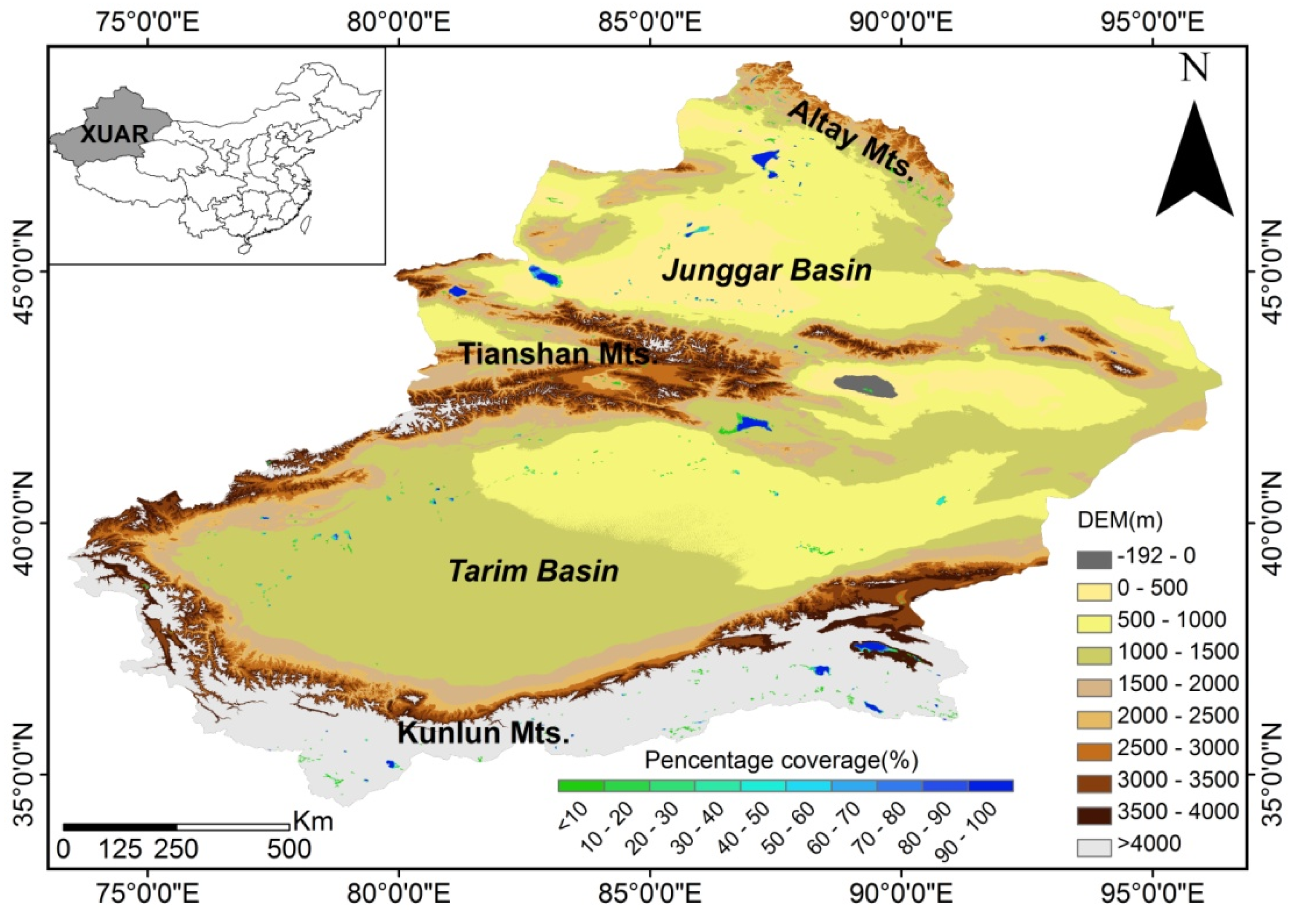
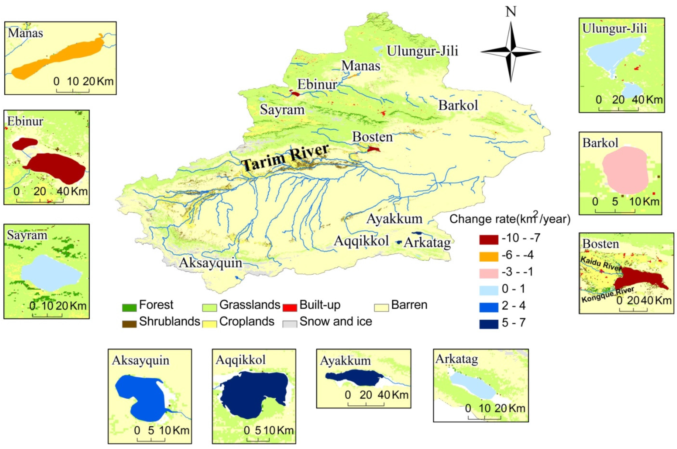
2. Study Area

| Name | Area (km2) | Altitude (m) | Mean Water Depth (m) | Region | Type |
|---|---|---|---|---|---|
| Ebinur | 673.46 | 194 | 1.2 | Junggar | Plain |
| Manas | 259.81 | 244 | 6 | Junggar | Plain |
| Ulungur-Jili | 1041.60 | 478 | 10.4 | Junggar | Plain |
| Bosten | 1004.33 | 1050 | 9 | Tarim | Transition |
| Sayram | 462.63 | 2072 | 46 | Junggar | Mountain |
| Barkol | 118.57 | 1577 | 0.6 | Junggar | Mountain |
| Ayakkum | 200.46 | 3876 | 10 | Kumukuli | Plateau |
| Aqqikkol | 168.93 | 4251 | 8 | Kumukuli | Plateau |
| Arkatag | 110.33 | 4713 | 8 | Kumukuli | Plateau |
| Aksayquin | 88.54 | 4844 | 8 | Northern Tibet | Plateau |
3. Materials and Methods
3.1. Remote Sensing Datasets
| Lake | Ulungur | Manas | Bosten | Ayakekumu |
|---|---|---|---|---|
| Sensors | Landsat5 TM | Landsat5 TM | Landsat5 TM | Landsat5 TM |
| Landsat7 ETM+ | Landsat7 ETM+ | Landsat7 ETM+ | Landsat7 ETM+ | |
| Landsat8 OLI_TIRS | Landsat8 OLI_TIRS | Landsat8 OLI_TIRS | Landsat8 OLI_TIRS | |
| Path/Row | 143/27, 144/27 | 144/28 | 143/31 | 140/34 |
| Date | 7 July 2000 | 16 March 2000 | 25 March 2000 | 4 September 2000 |
| 24 September 2000 | 6 July 2000 | 31 July 2000 | 29 July 2001 | |
| 13 April 2001 | 24 September 2000 | 17 September 2000 | 1 October 2001 | |
| 27 July 2002 | 19 March 2001 | 1 August2006 | 11 April 2002 | |
| 14 September 2002 | 10 April 2003 | 10 September 2006 | 1 August2002 | |
| 10 April 2003 | 31 July 2006 | 14 April 2007 | 4 October 2002 | |
| 24 July 2006 | 17 September 2006 | 27 July 2007 | 14 April 2003 | |
| 17 September 2006 | 4 September 2007 | 13 September 2007 | 19 April 2005 | |
| 6 April 2007 | 23 July 2009 | 2 May 2008 | 27 July 2006 | |
| 23 July 2009 | 9 September 2009 | 16 July 2009 | 13 September 2006 | |
| 18 September 2009 | 10 May 2011 | 3 April 2009 | 6 July 2007 | |
| 10 May 2011 | 13 July 2011 | 6 July 2011 | 25 April 2010 | |
| 13 July 2011 | 1 October 2011 | 24 September 2011 | 30 July 2010 | |
| 15 September 2011 | 13 April 2013 | 22 April 2013 | 31 August2010 | |
| 13 April 2013 | 2 July 2013 | 27 July 2013 | 8 May 2012 | |
| 11 July 2013 | 4 September 2013 | 29 September 2013 | 7 August2013 | |
| 29 September 2013 | 2 May 2014 | 31 August2014 | 24 September 2013 | |
| 25 April 2014 | 21 July 2014 | 6 May 2014 |
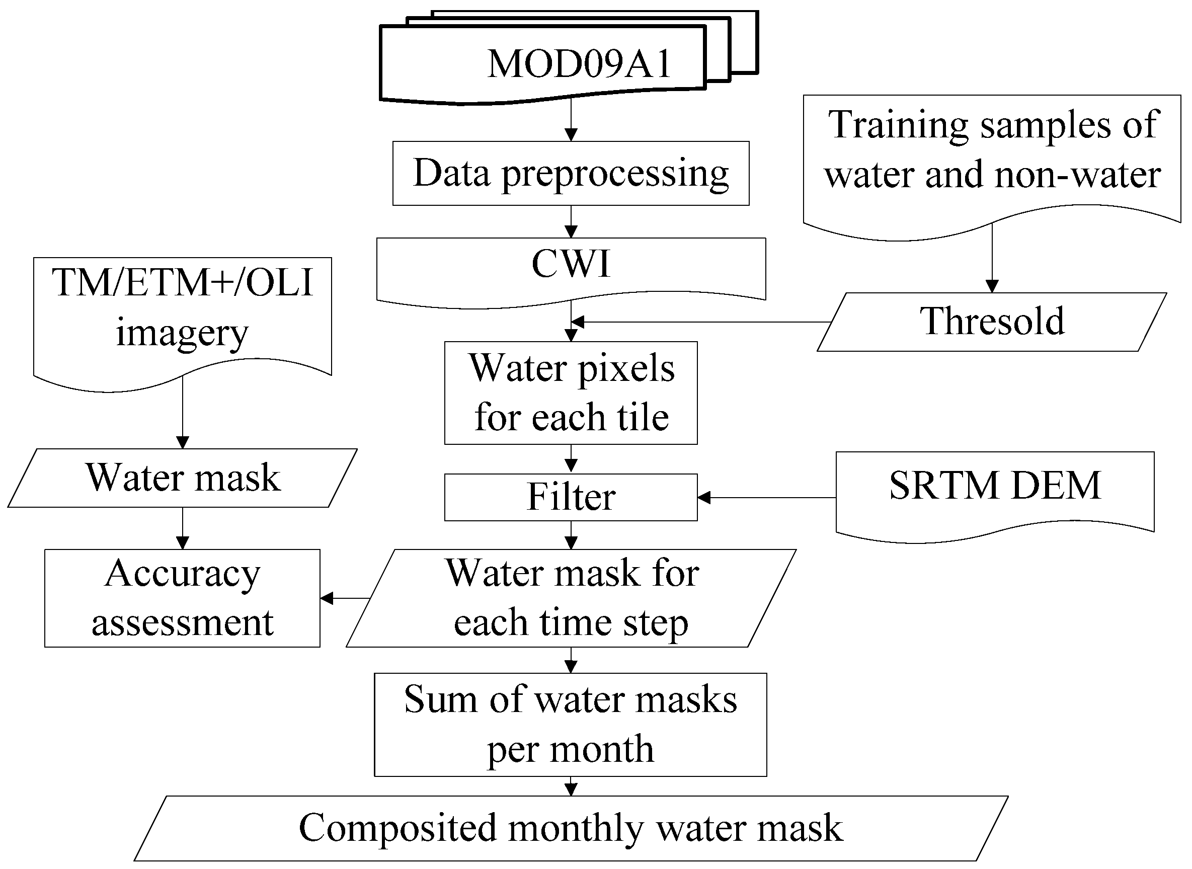
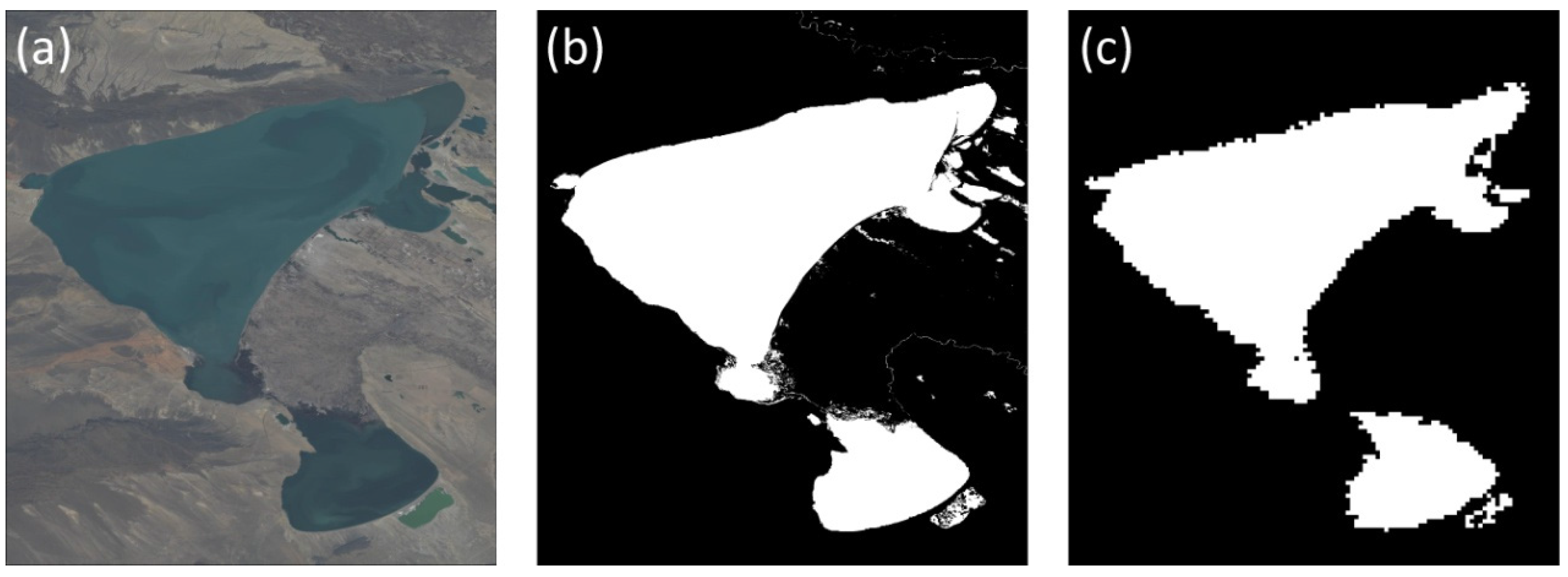
3.2. MODIS-Based Water Body Extraction

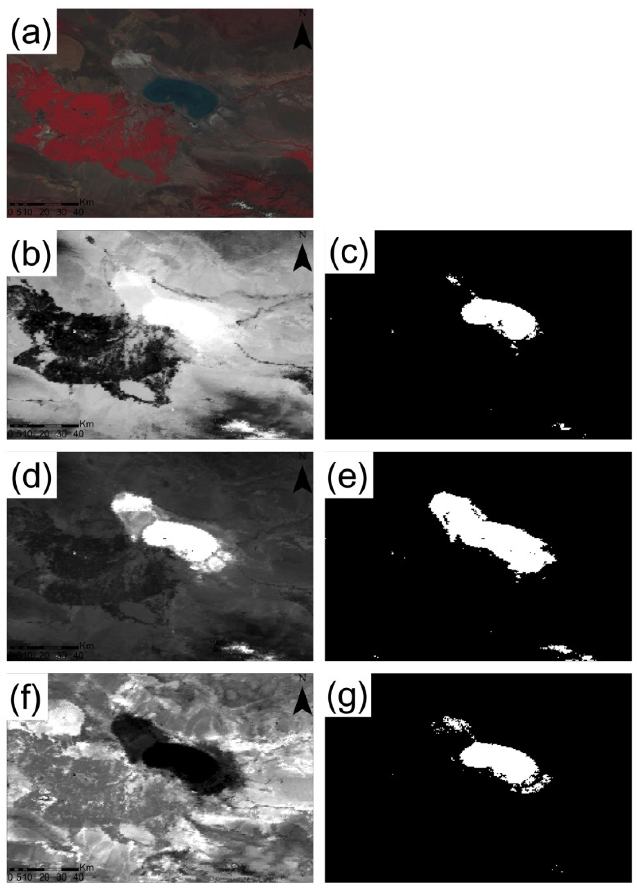
3.3. Accuracy Assessment
3.4. Data Sources of Climate and Human Activities
4. Results and Discussion
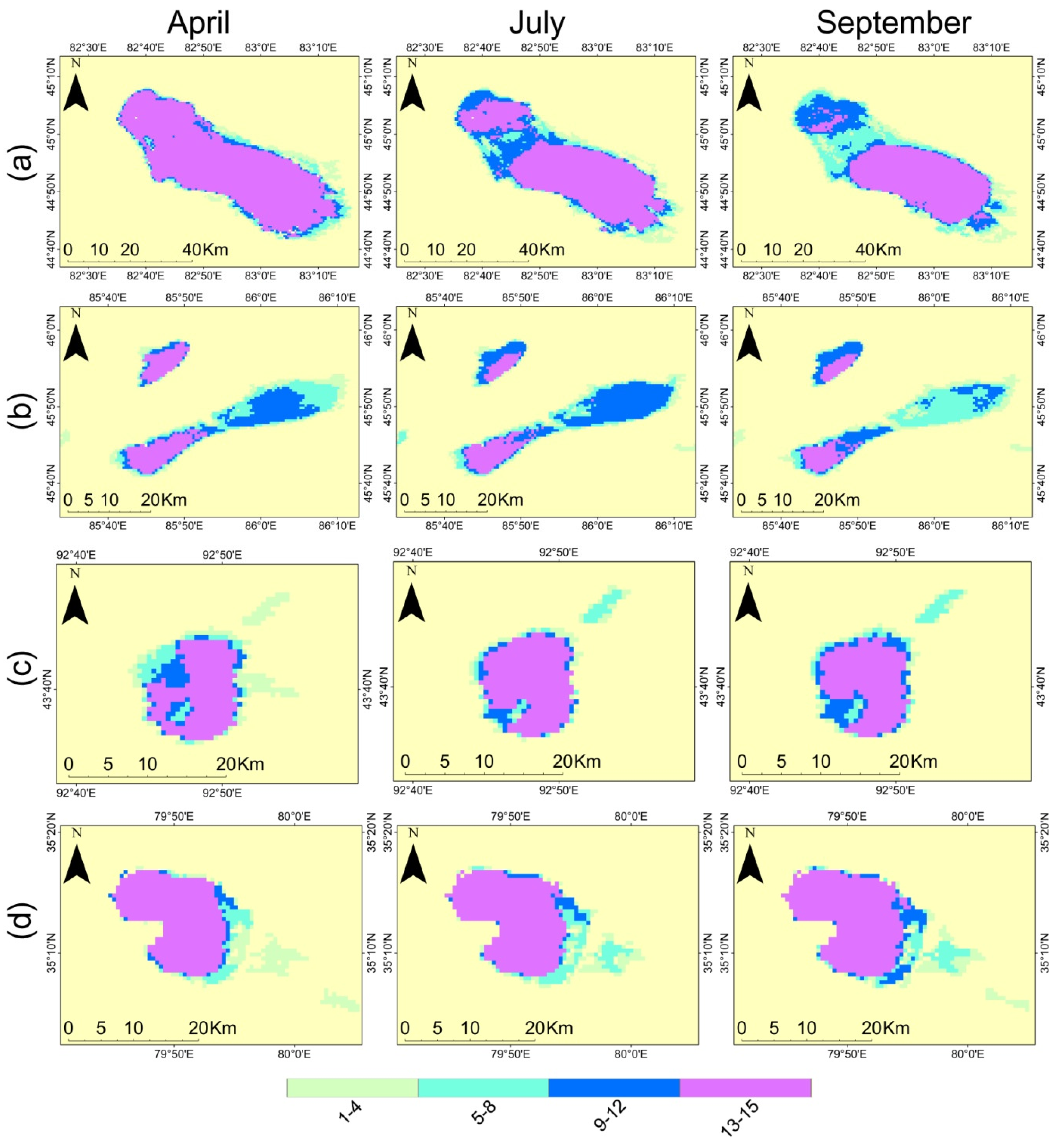
4.1. Intra- and Inter-Annual Dynamics of Water Bodies


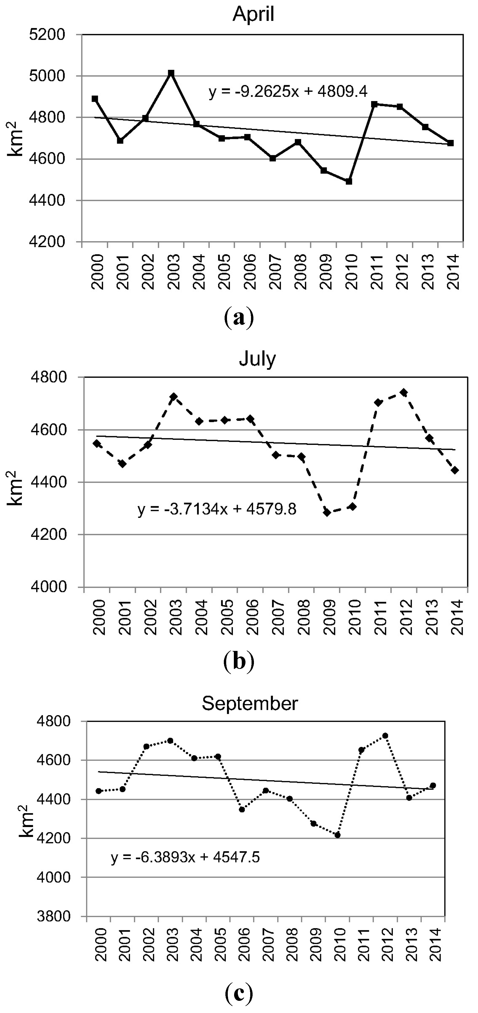
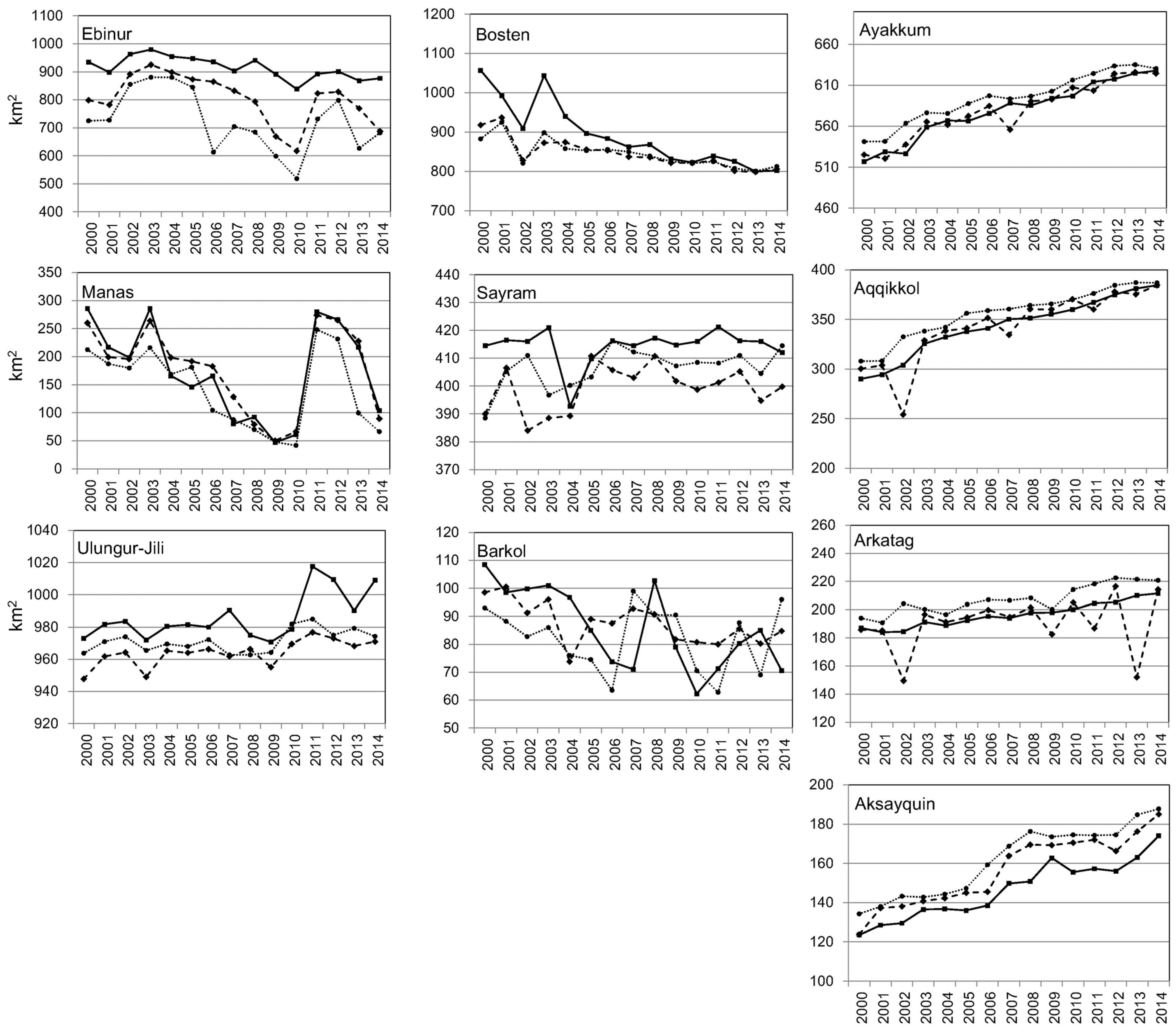
4.2. Temporal Variations of Major Water Bodies
| Name | April | July | September | Seasonality (max/min ratio) |
|---|---|---|---|---|
| Ebinur | −6.09 | −10.36 | −11.74 | 1.29 |
| Manas | −5.53 | −5.08 | −6.59 | 1.52 |
| Ulungur-Jili | 2.08 | 1.25 | 0.81 | 1.03 |
| Bosten | −16.71 | −7.78 | −6.36 | 1.06 |
| Sayram | 0.22 | 0.61 | 0.90 | 1.03 |
| Barkol | −2.32 | −1.07 | −0.43 | 1.38 |
| Ayakkum | 7.80 | 7.48 | 6.72 | 1.05 |
| Aqqikkol | 6.55 | 6.82 | 5.52 | 1.06 |
| Arkatag | 1.9 | 1.13 | 2.08 | 1.04 |
| Aksayquin | 3.21 | 3.88 | 3.92 | 1.15 |


4.3. Accuracy Assessment

| Month | Ulungur | Manas | Bosten | Ayakkum | ||||
|---|---|---|---|---|---|---|---|---|
| User | Prod | User | Prod | User | Prod | User | Prod | |
| April | 0.92 | 0.93 | 0.72 | 0.97 | 0.95 | 0.89 | 0.97 | 0.95 |
| July | 0.96 | 0.92 | 0.66 | 0.95 | 0.99 | 0.86 | 0.95 | 0.94 |
| September | 0.97 | 0.93 | 0.63 | 0.93 | 0.99 | 0.89 | 0.97 | 0.97 |
| Overall Accuracy | 0.97 | |||||||
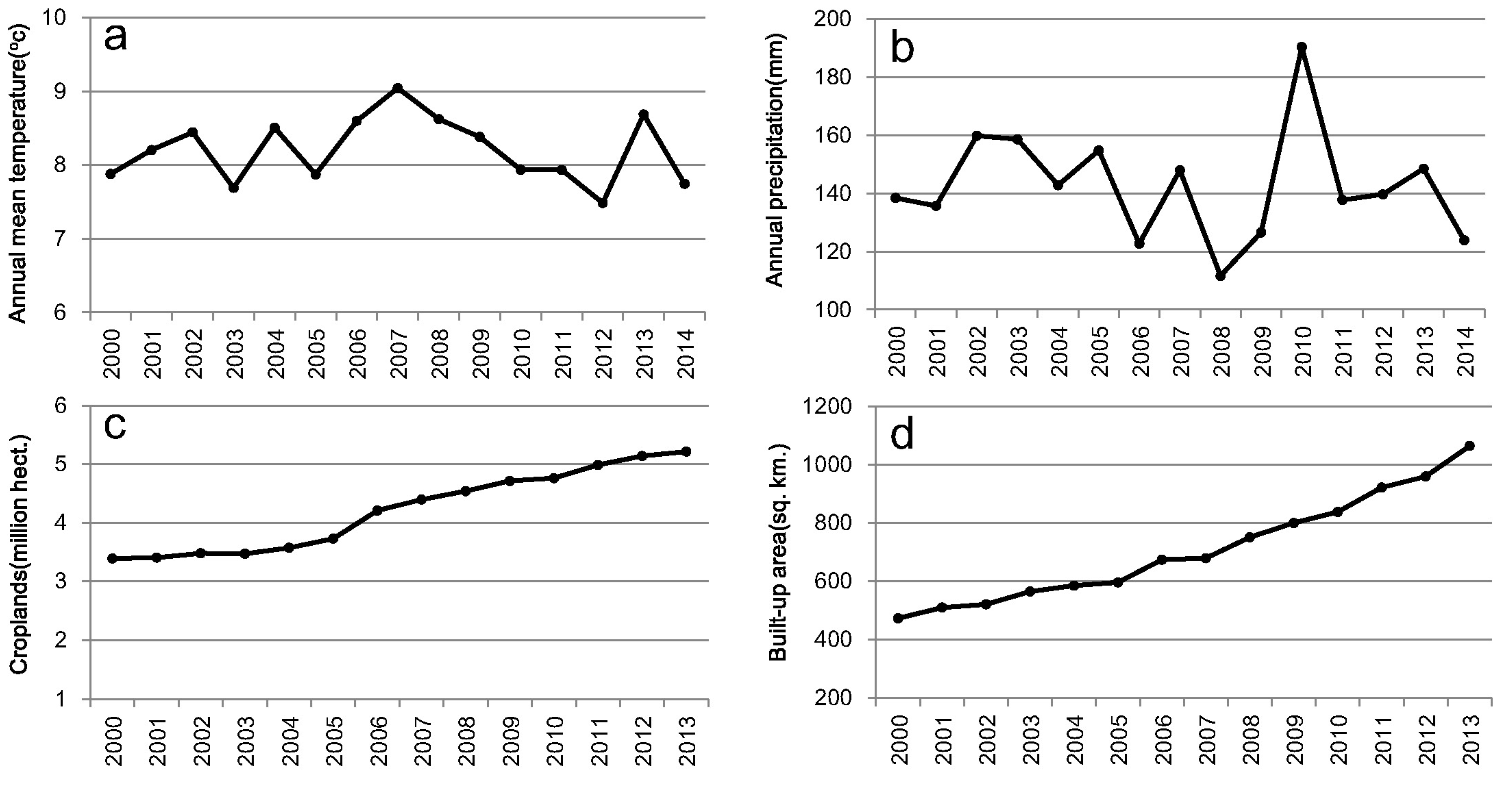
4.4. Effects of Regional Climate and Human Activities on Lake Changes

| Climate Variable | Ebinur | Manas | Ulungur-Jili | Bosten | Sayram | Barkol |
|---|---|---|---|---|---|---|
| Annual Mean Temperature (°C) | −0.20 | −0.06 | 0.31 | −0.26 | −0.27 | 0.51 |
| Annual Precipitation (mm) | −0.28 | −1.70 | −2.28 | −2.72 | −3.21 | 2.82 |
5. Conclusions
Acknowledgments
Author Contributions
Conflicts of Interest
References
- Oki, T.; Shinjiro, K. Global hydrological cycles and world water resources. Science 2006, 313, 1068–1072. [Google Scholar] [CrossRef] [PubMed]
- Soti, V.; Tran, A.; Bailly, J.S.; Puech, C.; Seen, D.L.; Bégué, A. Assessing optical earth observation systems for mapping and monitoring temporary ponds in arid areas. Int. J. Appl. Earth Obs. 2009, 11, 344–351. [Google Scholar] [CrossRef] [Green Version]
- Haas, E.M.; Bartholomé, E.; Lambin, E.F.; Vanacker, V. Remotely sensed surface water extent as an indicator of short-term changes in ecohydrological processes in sub-Saharan Western Africa. Remote Sens. Environ. 2011, 115, 3436–3445. [Google Scholar] [CrossRef]
- Haas, E.M.; Bartholomé, E.; Combal, B. Time series analysis of optical remote sensing data for the mapping of temporary surface water bodies in sub-Saharan western Africa. J. Hydrol. 2009, 370, 52–63. [Google Scholar] [CrossRef]
- Lehner, B.; Doll, P. Development and validation of a global database of lakes, reservoirs and wetlands. J. Hydrol. 2004, 296, 1–22. [Google Scholar] [CrossRef]
- Vector Map Level 0 (VMap0). Available online: http://earth-info.nga.mil/publications/vmap0.html (accessed on 16 February 2015).
- Li, W.; Du, Z.; Ling, F.; Zhou, D.; Wang, H.; Gui, Y.; Sun, B.; Zhang, X. A comparison of land surface water mapping using the normalized difference water index from TM, ETM+ and ALI. Remote Sens. 2013, 5, 5530–5549. [Google Scholar] [CrossRef]
- Song, C.; Huang, B.; Ke, L. Modeling and analysis of lake water storage changes on the Tibetan Plateau using multi-mission satellite data. Remote Sens. Environ. 2013, 135, 25–35. [Google Scholar] [CrossRef]
- Fujita, K.; Sakai, A.; Nuimura, T.; Ymaguchi, S.; Sharma, R.R. Recent changes in Imja Glacial Lake and its damming moraine in the Nepal Himalaya revealed by in situ surveys and multi-temporal ASTER imagery. Environ. Res. Lett. 2009, 4. [Google Scholar] [CrossRef]
- Lira, J. Segmentation and morphology of open water bodies from multispectral images. Int. J. Remote Sens. 2006, 27, 4015–4038. [Google Scholar] [CrossRef]
- Lacaux, J.P.; Tourre, Y.M.; Vignolles, C.; Ndione, J.A.; Lafaye, M. Classification of ponds from high-spatial resolution remote sensing: Application to rift valley fever epidemics in Senegal. Remote Sens. Environ. 2007, 106, 66–74. [Google Scholar] [CrossRef]
- Chipman, J.W.; Lillesand, T.M. Satellite-based assessment of the dynamics of new lakes in southern Egypt. Int. J. Remote Sens. 2007, 28, 4365–4379. [Google Scholar] [CrossRef]
- Sun, F.; Zhao, Y.; Gong, P.; Ma, R.; Dai, Y. Monitoring dynamic changes of global land cover types: Fluctuations of major lakes in China every 8 days during 2000–2010. Chin. Sci. Bull. 2014, 59, 171–189. [Google Scholar] [CrossRef]
- Klein, I.; Dietz, A.J.; Gessner, U.; Galayeva, A.; Myrzakhmetov, A.; Kuenzer, C. Evaluation of seasonal water body extents in Central Asia over the past 27 years derived from medium-resolution remote sensing data. Int. J. Appl. Earth Obs. 2014, 26, 335–349. [Google Scholar] [CrossRef]
- Deus, D.; Gloaguen, R. Remote sensing analysis of lake dynamics in semi-arid regions: Implication for water resource management. Lake Manyara, East African Rift, Northern Tanzania. Water 2013, 5, 698–727. [Google Scholar] [CrossRef]
- Wang, J.; Sheng, Y.; Tong, T.S.D. Monitoring decadal lake dynamics across the Yangtze Basin downstream of Three Gorges Dam. Remote Sens. Environ. 2014, 152, 251–269. [Google Scholar] [CrossRef]
- Mcfeeters, S.K. The use of normalized difference water index (NDWI) in the delineation of open water features. Int. J. Remote Sens. 1996, 17, 1425–1432. [Google Scholar] [CrossRef]
- Xu, H. Modification of normalized difference water index (NDWI) to enhance open water features in remotely sensed imagery. Int. J. Remote Sens. 2006, 27, 3025–3033. [Google Scholar] [CrossRef]
- Mo, W.; Sun, H.; Zhong, S.; Huang, Y.; He, L. Research on the CIWI model and its application. Remote Sens. Inf. 2007, 5, 16–21. [Google Scholar]
- Song, C.; Huang, B.; Ke, L.; Richards, K.S. Remote sensing of alpine lake water environment changes on the Tibetan Plateau and surroundings: A review. ISPRS J. Photogramm. Remote Sens. 2014, 92, 26–37. [Google Scholar] [CrossRef]
- Chinese Academy of Forestry. The List of National Nature Reserve in China. 2013. Available online: http://www.papc.cn/ (accessed on 16 August 2015).
- Bai, J.; Chen, X.; Li, J.; Yang, L.; Fang, H. Changes in the area of inland lakes in arid regions of central Asia during the past 30 years. Environ. Monit. Assess. 2011, 178, 247–256. [Google Scholar] [CrossRef] [PubMed]
- Ma, M. Change in area of Ebinur Lake during the 1998–2005 period. Int. J. Remote Sens. 2007, 28, 5523–5533. [Google Scholar] [CrossRef]
- Ma, R.; Duan, H.; Hu, C.; Feng, X.; Li, A.; Ju, W. A half-century of changes in China’s lakes: Global warming or human influence? Geophys. Res. Lett. 2010, 37. [Google Scholar] [CrossRef]
- Yang, X.K.; Lu, X.X. Drastic change in China’s lakes and reservoirs over the past decades. Sci. Rep. 2014, 4. [Google Scholar] [CrossRef]
- Bai, R.; He, L.; Wu, J. Analysis on recent change of water area of the main lakes in Xinjiang based on MODIS data. Arid Zone Res. 2012, 29, 561–566. [Google Scholar]
- Wang, T.; Yan, C.Z.; Song, X.; Xie, J.L. Monitoring recent trends in the area of Aeolian desertified land using Landsat images in China’s Xinjiang region. ISPRS J. Photogramm. Remote Sens. 2012, 68, 184–190. [Google Scholar] [CrossRef]
- Lu, L.; Kuenzer, C.; Wang, C.; Guo, H.; Li, Q. Evaluation of three MODIS-derived vegetation index time series for dryland vegetation dynamics monitoring. Remote Sens. 2015, 7, 7597–7614. [Google Scholar] [CrossRef]
- Vermote, E.F.; Kotchenova, S.Y.; Ray, J.P. MODIS surface reflectance user’s guide. Available online: http://modis-sr.ltdri.org/guide/MOD09_UserGuide_v1_3.pdf (accessed on 16 August 2015).
- Huang, S.; Li, J.; Xu, M. Water surface variations monitoring and flood hazard analysis in Dongting Lake area using long-term Terra/MODIS data time series. Nat. Hazards 2012, 62, 93–100. [Google Scholar] [CrossRef]
- Caroll, M.L.; Townshend, J.R.; DiMiceli, C.W.; Noojipady, P.; Sohlberg, R.A. A new global raster water mask at 250 m resolution. Int. J. Digit. Earth 2009, 2, 291–308. [Google Scholar] [CrossRef]
- Huesler, F.; Jonas, T.; Wunderle, S.; Albrecht, S. Validation of a modified snow cover retrieval algorithm from historical 1-km AVHRR data over the European Alps. Remote Sens. Environ. 2012, 121, 497–515. [Google Scholar] [CrossRef]
- Friedl, M.A.; Sulla-Menashe, D.; Tan, B.; Schneider, A.; Ramankutty, N.; Sibley, A.; Huang, X. MODIS Collection 5 global land cover: Algorithm refinements and characterization of new datasets. Remote Sens. Environ. 2010, 114, 168–182. [Google Scholar] [CrossRef]
- Lu, L.; Kuenzer, C.; Guo, H.; Li, Q.; Long, T.; Li, X. A novel land cover classification map based on a MODIS time-series in Xinjiang, China. Remote Sens. 2014, 6, 3387–3408. [Google Scholar] [CrossRef]
- Feng, L.; Hu, C.; Chen, X.; Cai, X.; Tian, L.; Gan, W. Assessment of inundation changes of Poyang Lake using MODIS observations between 2000 and 2010. Remote Sens. Environ. 2012, 121, 80–92. [Google Scholar] [CrossRef]
- Lu, S.; Wu, B.; Yan, N.; Wang, H. Water body mapping method with HJ-1A/B satellite imagery. Int. J. Appl. Earth Obs. 2011, 13, 428–434. [Google Scholar] [CrossRef]
- Congalton, R.G.; Green, K. Assessing the Accuracy of Remotely Sensed Data: Principles and Practices, 2nd ed.; CRC Press: Boca Raton, FL, USA, 2009. [Google Scholar]
- Frazier, P.S.; Page, K.J. Water body detection and delineation with Landsat TM data. Photogramm. Remote Sens. 2000, 66, 1461–1467. [Google Scholar]
- Xinjiang Uygur Autonomous Region Bureau of Statistics. Xinjiang Uygur Autonomous Region Statistical Yearbook; China Statistics Press: Beijing, China; pp. 2001–2004.
- Zhang, F.; Tiyip, T.; Johnson, V.C.; Kung, H.; Ding, J.; Zhou, M.; Fan, Y.; Kelimu, A.; Nurmuhammat, I. Evaluation of land desertification from 1990 to 2010 and its causes in Ebinur Lake region, Xinjiang China. Environ. Earth Sci. 2015, 73, 5731–5745. [Google Scholar] [CrossRef]
- Cheng, W.; Zhou, C.; Liu, H.; Zhang, Y.; Jiang, Y.; Zhang, Y.; Yao, Y. The oasis expansion and eco-environment change over the last 50 years in Manas River Valley, Xinjiang. Sci. China Ser. D 2006, 49, 163–175. [Google Scholar] [CrossRef]
- Wu, J.; Zeng, H.; Ma, L.; Bai, R. Recent changes of selected lake water resources in arid Xinjiang, northwestern China. Quat. Sci. 2012, 32, 142–150. [Google Scholar]
- Maitiniyazi, A.; Kasimu, A. Change trend of surface water resources in Altai, Xinjiang China. J. Desert Res. 2014, 34, 1393–1401. [Google Scholar]
- Gao, H.; Yao, Y. Quantitative effect of human activities on water level change of Bosten Lake in recent 50 years. Sci. Geogr. Sin. 2005, 25, 305–309. [Google Scholar]
- Liu, L.; Zhao, J.; Zhang, J.; Peng, W.; Fan, J.; Zhang, T. Water balance of Lake Bosten using annual water-budget method for the past 50 years. Arid Land Geogr. 2013, 36, 33–40. [Google Scholar]
- Guo, M.; Wu, W.; Zhou, X.; Chen, Y.; Li, J. Investigation of the dramatic changes in lake level of the Bosten Lake in northwestern China. Theor. Appl. Climatol. 2015, 119, 341–351. [Google Scholar] [CrossRef]
- Ma, D.; Zhang, L.; Wang, Q.; Zeng, Q.; Jiang, F.; Wang, Y.; Hu, R. Influence of warm-wet climate on Sailimu Lake. J. Glaciol. Geocryol. 2003, 25, 219–223. [Google Scholar]
- Xue, J.; Zhong, W. Holocene climate variation denoted by Barkol lake sediments in northeastern Xinjiang and its possible linkage to the high and low latitude climates. Sci. China Earth Sci. 2011, 54, 603–614. [Google Scholar] [CrossRef]
- Zheng, S.; Luo, L. Variation of water quality in Balikun Lake in the last 18 years and water resource protection strategies. Environ. Sci. Tech. 2011, 34, 85–88. [Google Scholar]
- Zhang, G.; Xie, H.; Kang, S.; Yi, D.; Ackley, S.F. Monitoring lake level changes on the Tibetan Plateau using ICESat altimetry data (2003–2009). Remote Sens. Environ. 2011, 115, 1733–1742. [Google Scholar] [CrossRef]
- Liao, J.; Shen, G.; Li, Y. Lake variations in response to climate change in the Tibetan Plateau in the past 40 years. Int. J. Digit. Earth 2013, 6, 534–549. [Google Scholar] [CrossRef]
- Yao, T.; Pu, J.; Lu, A.; Wang, Y.; Yu, W. Recent glacial retreat and its impact on hydrological processes on the Tibetan Plateau, China, and surrounding regions. Arct. Antarct. Alp. Res. 2007, 39, 642–650. [Google Scholar] [CrossRef]
- Cheng, G.; Wu, T. Responses of permafrost to climate change and their environmental significance, Qinghai-Tibet Plateau. J. Geophys. Res. 2007, 112. [Google Scholar] [CrossRef]
- Li, Y.; Liao, J.; Guo, H.; Liu, Z.; Shen, G. Patterns and potential drivers of dramatic changes in Tibetan lakes, 1972–2010. PLoS ONE 2014, 9. [Google Scholar] [CrossRef] [PubMed]
- Lioubimtseva, E.; Henebry, G.M. Climate and environmental change in arid Central Asia: Impacts, vulnerability, and adaptations. J. Arid Environ. 2009, 73, 963–977. [Google Scholar]
© 2015 by the authors; licensee MDPI, Basel, Switzerland. This article is an open access article distributed under the terms and conditions of the Creative Commons Attribution license (http://creativecommons.org/licenses/by/4.0/).
Share and Cite
Li, Q.; Lu, L.; Wang, C.; Li, Y.; Sui, Y.; Guo, H. MODIS-Derived Spatiotemporal Changes of Major Lake Surface Areas in Arid Xinjiang, China, 2000–2014. Water 2015, 7, 5731-5751. https://doi.org/10.3390/w7105731
Li Q, Lu L, Wang C, Li Y, Sui Y, Guo H. MODIS-Derived Spatiotemporal Changes of Major Lake Surface Areas in Arid Xinjiang, China, 2000–2014. Water. 2015; 7(10):5731-5751. https://doi.org/10.3390/w7105731
Chicago/Turabian StyleLi, Qingting, Linlin Lu, Cuizhen Wang, Yingkui Li, Yue Sui, and Huadong Guo. 2015. "MODIS-Derived Spatiotemporal Changes of Major Lake Surface Areas in Arid Xinjiang, China, 2000–2014" Water 7, no. 10: 5731-5751. https://doi.org/10.3390/w7105731