1. Introduction
Groundwater resource assessment is germane to estimation of net recharge to the aquifers. A wide range of direct and indirect methods to estimate groundwater recharge, with varying degree of complexity and approximation on the range of spatial and temporal scales is available [
1,
2,
3,
4], but difficulties arise in complex karst hydrogeologic settings [
5,
6]. Recharge assessment is particularly challenging in semi-arid regions as recharge producing rainfall is highly irregular or episodic [
7]. Aquifer water level response time may differ as the point and diffuse recharge residence times vary. Karst landscapes are often characterized by the presence of sinkholes, caves and underground conductive zones, formed primarily by dissolution of soluble limestone and dolomite. The presence of sinkholes gives a distinct recharge feature to karst systems via the duality of flow regimes, which can be separated into point (shaft and conduit dominated), and diffuse (matrix, meso-pore, and macro-pore dominated) infiltration and recharge.
Because of their high yields, carbonate aquifers are commonly used for community and non-community water supplies [
8]. For example, 25% of drinking water supplies are sourced from a geological setting covering approximately 10% of the earth’s land surface [
9,
10,
11], and comprise some 40% of the groundwater of the United States [
12]. In Europe, more than 30% of the land surface is made up of karst exposures with more than half the drinking water supply derived from karst aquifers in some countries [
13]. Karst aquifers are poorly understood due to the spatial and temporal complexity of flow patterns caused by widely varying porosity and flow regimes [
11].
A distinct recharge feature of karst systems is the duality of porosity, infiltration and recharge [
5,
6,
14]. Karst limestone aquifers are hydrologically and hydrochemically extremely heterogeneous and point source recharge via sinkholes and fissures are common. In characterizing properties of a karst aquifer, quantitative water tracing tests utilizing fluorescent dyes, are among the most useful field methods [
6]. Alternatively, naturally occurring tracers such as chloride and stable isotopic signatures of the water molecule (δ
2H and δ
18O) can be used to identify recharge and groundwater mixing, with either low salinity rainwater or surface water entering the aquifer via a point recharge source [
15,
16]. Herczeg
et al. [
16] suggest that the stable isotopic composition of waters recharging via sinkholes tends to be enriched in
2H and
18O relative to regional groundwater and local precipitation, due to the small degree of evaporation before recharge. Point-recharge is usually intermittent and transient. Discrete recharge to a karst aquifer, occurring through sinkholes, typically has numerous inputs of surface water to the subsurface, with water draining along cracks and fissures (macropores), rapidly transmitting water from the surface [
17]. Hydrologic characteristics of karst aquifers are determined largely by the structures and organization of the conduits [
18]. Rapid flow through point sources [
19,
20,
21,
22] is a common feature in highly heterogeneous and anisotropic [
18,
23] karst aquifers. Identification of groundwater flow paths in karst aquifers is therefore problematic [
20].
One inherent problem from the presence of karstic features such as sinkholes is the recharge estimation. Whilst connected sinkholes transfer surface water to groundwater rapidly through shafts and conduits systems, unconnected sinkholes can act as regions of both rapid and slow recharge [
24]. Sinkholes connected to the watertable bypass the soil zone, directly recharging the aquifer as point recharge. Unconnected sinkholes add runoff deeper into the unsaturated zone, which can then rapidly drain into the watertable via macropores and slow infiltration through the soil profile between the sinkhole bottom and watertable plane [
14,
24]. Karstic features supply a significant amount of recharge to many carbonate aquifers in temperate and humid regions throughout the world [
16], yet the applicability of the assumptions used in recharge estimation methods has not been studied. For example, the fundamental basis of the conventional CMB method is that recharge mass flux crossing the watertable plane can be calculated if the following conditions are met [
25,
26,
27]:
chloride in the groundwater originates from precipitation directly on the aquifer, and no unmeasured runoff occurs;
there is steady influx of water and chloride; and
chloride is conservative in the system and there are no other sources or sink in the aquifer,
Problems arise holding above assumptions, which rely on steady chloride mass flux crossing the watertable plane and long-term average annual rainfall. Under point recharge situations, it appears that the basic premise of the conventional CMB method is violated.
This study addresses karst systems, with particular reference to the chloride vs δ18O relation, groundwater mixing, preferential flowpaths and water level response of karst aquifers to episodic and annual rainfalls, with respect to the validity of assumptions of the commonly used recharge estimation method, the conventional CMB.
2. Description of the Study Basins
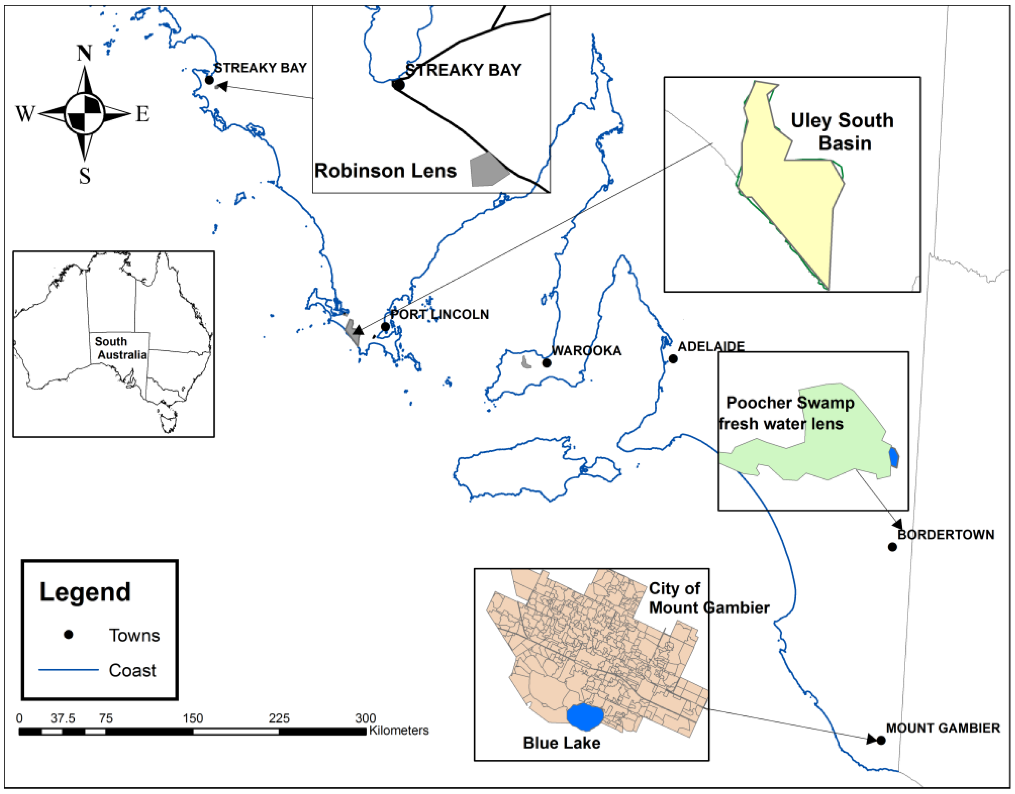
Four groundwater basins, based on data availability and differing rainfall zones, in karstic settings in South Australia (
Figure 1) are examined.
Figure 1.
Location of study basins.
Figure 1.
Location of study basins.
The basins are characterized by both point and diffuse recharge. In the Robinson lens and Uley South basin, point recharge is through solution features and diffuses recharge through granular porosity of pockets of soil and minor fissures and cracks. In the city of Mount Gambier within the Blue Lake capture zone, point recharge is mainly through about 400 storm water drainage wells and three sinkholes [
28]. In Poocher Swamp, the majority of recharge is from a large volume of creek water discharge into two sinkholes, resulting in formation of a fresh water lens [
29]. Groundwater basins Uley South [
30,
31], Robinson lens [
31], and Blue Lake capture zone in Mount Gambier [
28] are previously described and therefore essential hydrogeogical features of the basins are provided below.
Robinson lens is a small fresh groundwater lens (4.7 km
2) located on the western Eyre Peninsula, 8 km south-east of the township of Streaky Bay (
Figure 1). This basin has provided reticulated water supply to the township for more than 70 years. Average annual rainfalls is 375 mm and mean annual pan evaporation is 2200 mm. Falling water levels and rising groundwater salinity have been observed indicating that extraction from the lens exceeds recharge (
Figure 2). Groundwater extraction from the basin ceased in 2005, and since then, recovery of approximately 60% has been observed as of January 2014. The basin area is overlain by unconsolidated calcareous sand and calcarenite of the Bridgewater Formation [
32], which is capped by calcrete. Immediately underlying the Bridgewater Formation are stiff plastic Tertiary clays of the Wanilla Formation. Beneath this sequence are unnamed brackish to saline Jurassic sands and silts. Significant karst development in the form of dissolution features are common, and are evident on the calcrete exposures in the lower topographic depressions. The origin of the fresh water lens is attributed to runoff flowing to the low-lying parts of the lens where karst topography allows recharge to occur very quickly via 29 major solution features spread across the lens. Depth to water is 4 to 20 m suggesting that the watertable is not directly influenced by evaporation [
32].
Figure 2.
Conceptual diagram of the Robinson lens.
Figure 2.
Conceptual diagram of the Robinson lens.
The second study site is the Uley South basin; approximately 113 km
2 in area is located on the Southern Eyre Peninsula of South Australia (
Figure 1). Average annual rainfall is 550 mm and average annual pan evaporation is 1550 mm. The basin has been used for reticulated town water supply since 1976 and currently about 6.8 × 10
6 m
3 per year of groundwater is extracted from the Quaternary limestone aquifer. The surface geology of the Uley South basin is Quaternary sediments of Bridgewater Formation unconformably overlying Proterozoic volcano-sedimentary basement sequence [
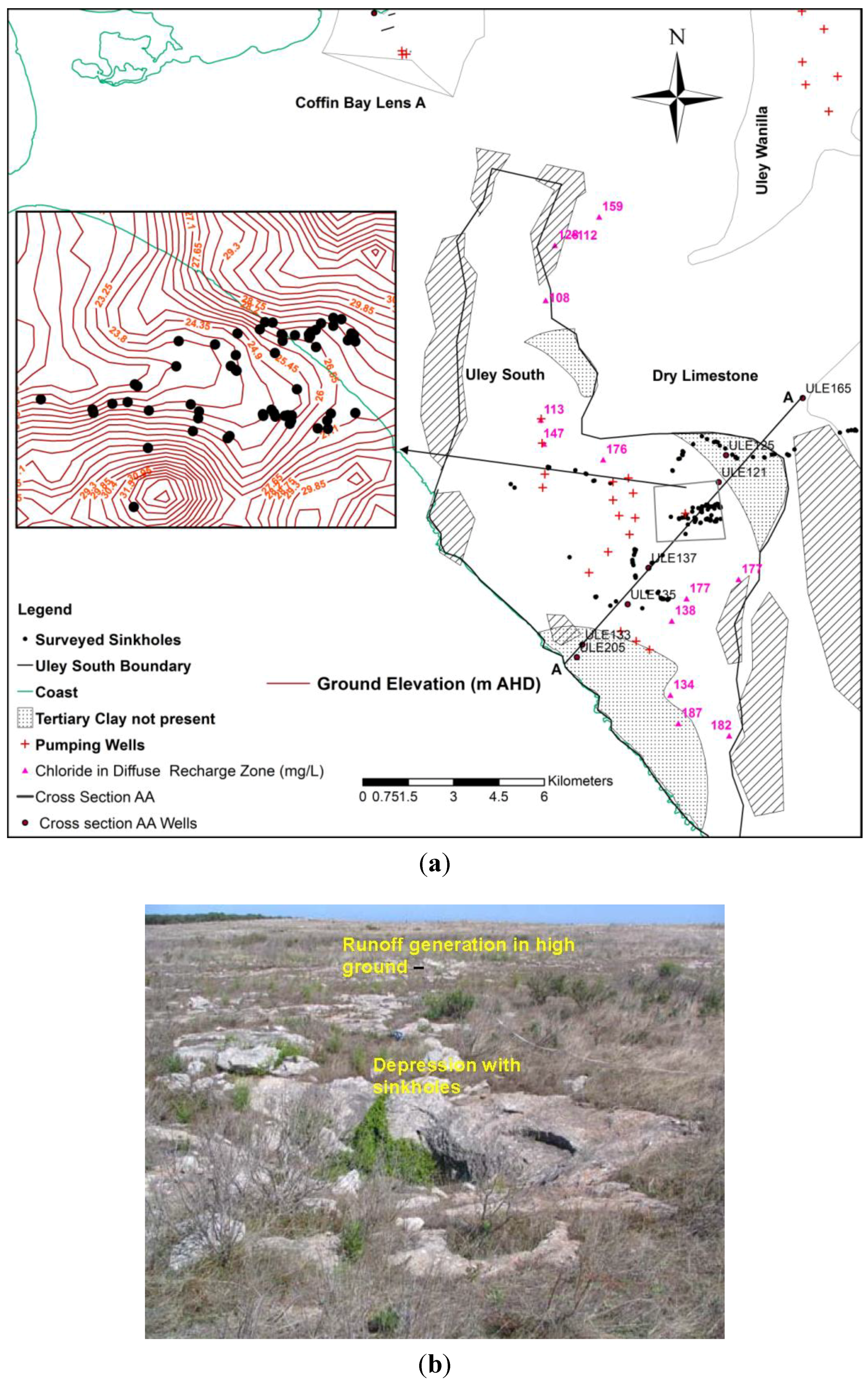
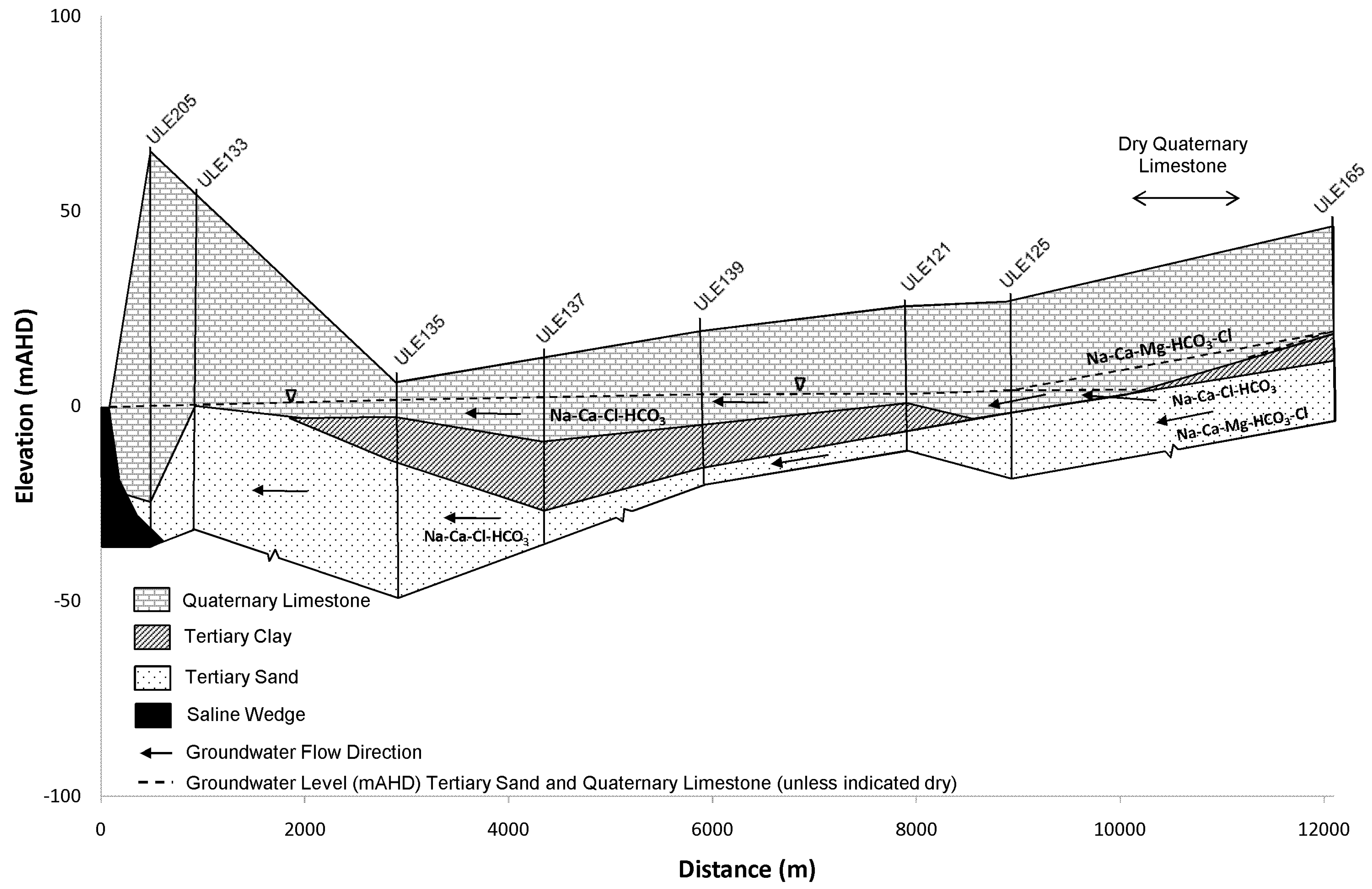
33]. The hydrogeology of Uley South basin comprises Quaternary limestone of an average thickness of 15 m, followed by a Tertiary clay unit of 5–25 m thickness, and a Tertiary sand aquifer (
Figure 3 and
Figure 4). The Tertiary clay forms an aquitard between the Tertiary sand and the Quaternary aquifer systems. Groundwater flow direction is from north-east to south-west. The basin is topographically closed and bounded by coastline and sand dunes to the west and inland to the north and east by topographic rises of dry limestone (allogenic zone), except along the north-eastern edge. The low lying central part of the basin contains numerous sinkholes (autogenic zone). Runoff is highly ephemeral, occurring only after moderate to high intensity rainfall and persisting only tens to hundreds of meters before entering a sinkhole [
33,
34,
35]. A survey of a 4 km
2 area found a density of about one sinkhole per 0.07 km
2 with approximate size ranging from 0.4 m to 2.5 m diameter [
36].
Figure 3.
Sinkholes in Uley South basin (a) Surveyed sinkholes (b) View of a sinkhole in a natural depression.
Figure 3.
Sinkholes in Uley South basin (a) Surveyed sinkholes (b) View of a sinkhole in a natural depression.
Figure 4.
Cross section AA—Uley South basin [
30].
Figure 4.
Cross section AA—Uley South basin [
30].
The third study area is the Blue Lake capture zone in the city of Mount Gambier. Blue Lake is a volcanic crater complex, and is the water supply reservoir for the city [
37] located in the south-east of South Australia (
Figure 1). The lake is groundwater fed through an extensive karst aquifer [
38,
39]. Currently 3.6 × 10
6 m
3 is extracted annually for town water supply. The main source of recharge to the Blue Lake is groundwater from the unconfined, Gambier karstic limestone aquifer underlying the urban area. Average saturated thickness of the Gambier limestone aquifer is about 60 m. Storm water derived from the central 16.8 km
2 of the city area (26.5 km
2) is discharged to the unconfined aquifer through three sinkholes and about 400 storm water drainage wells [
40].
The Blue lake capture zone is located about 20 km from the coastline. Average annual rainfall in Mount Gambier is 750 mm and average annual pan evaporation is 1400 mm. Regional groundwater flow direction is from north to south; however, Blue Lake receives groundwater flow from the north-west to north-east direction of the capture zone [
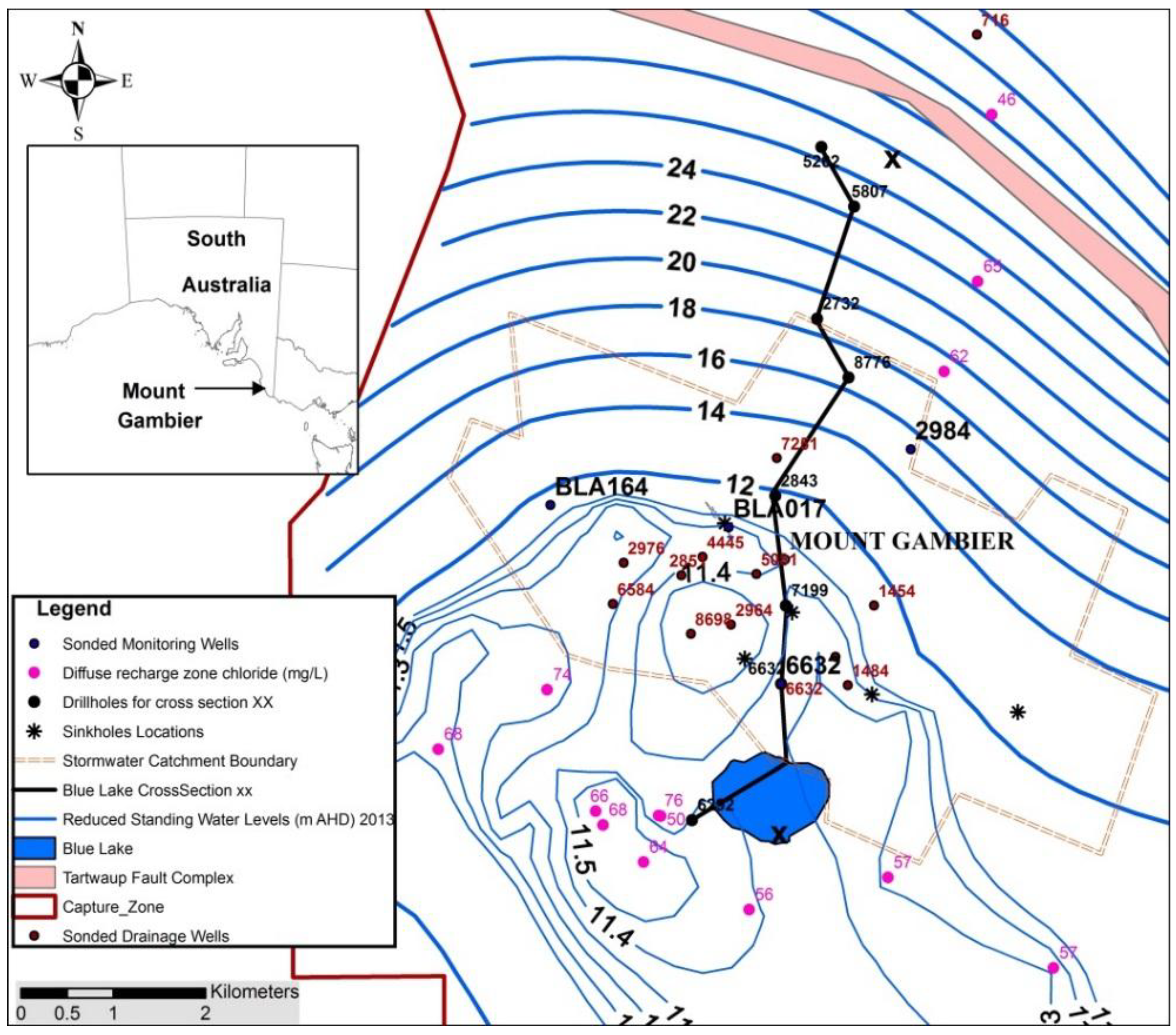
41]. The study area is located within the Blue Lake capture zone of the Gambier Basin (
Figure 5), a mixed sequence of marine and terrestrial deposits [
42].
Figure 5.
Mount Gambier city area of the Blue Lake capture zone.
Figure 5.
Mount Gambier city area of the Blue Lake capture zone.
The main geological units in the Mount Gambier area, in downward order, consist of Holocene volcanic deposits, the Bridgewater Formation (stranded Pleistocene beach dunes), the Gambier Limestone and the Dilwyn Formation [
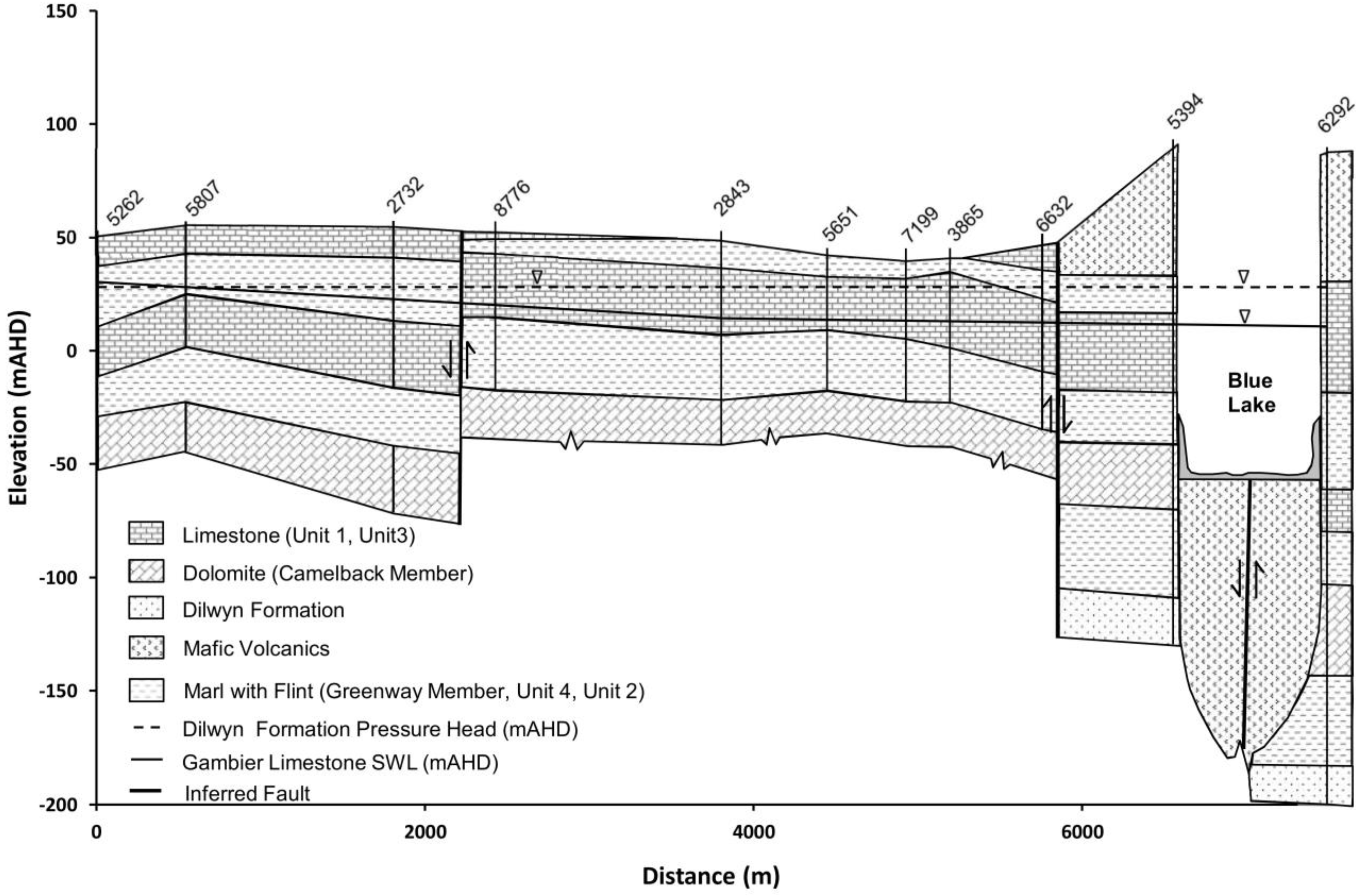
43]. The unconfined aquifer within the Gambier Limestone is a continuous system and an important supplier of groundwater throughout the region. Karstic features are common within the Gambier Limestone. Underlying the Gambier Limestone is the Dilwyn Formation, which comprises a series of unconsolidated sands with carbonaceous clay interbeds (
Figure 6). The Dilwyn Formation hosts a confined aquifer with higher salinity than the Gambier Limestone. A major fault underlies the Blue Lake, which is thought to represent a zone of regional structural weakness through which volcanic activity has occurred.
Figure 6.
North-south cross section across the city—XX in
Figure 5 [
28].
Figure 6.
North-south cross section across the city—XX in
Figure 5 [
28].
Recently, Lawson [
41] refined the stratigraphy of the Gambier Limestone surrounding the Blue Lake, defining the subunits within the Gambier Limestone in hydrostratigraphic terms (
Figure 6). The following are general descriptions of the unconfined aquifer hydrostratigraphic unit characteristics as described by Lawson [
41] and Li
et al. [
44]. Green Point Member Unit 1 (Unit 1) is a transmissive bryozoal limestone with marl and flint inclusions. Green Point Member Unit 2 (Unit 2) is composed of marls and flints, has the potential to act as a semi-confining unit and is characterised by generally lower transmissivities with associated low hydraulic conductivity. Green Point Member Unit 3 (Unit 3) is described as an open transmissive bryozoal limestone. It contains minor fracturing and may be partly dolomitised. This unit is characterised by higher aquifer transmissivities and associated hydraulic conductivity. Green Point Member Unit 4 (Unit 4) is typically described as a deep marl section within the limestone. It may act as an aquitard with typically associated lower hydraulic conductivity. Camelback Member is a dual porosity unit, characterised by extensive fracturing at the subunit intersection point. This results in extremely high porosities and hydraulic conductivities. The non-fractured sections of the subunit are composed of fine dolomitic rhombs and have transmissivities probably similar to or lower than bryozoal sections of limestone. Greenways Member is typically described as grey basal marl with resultant low transmissivities and hydraulic conductivity [
28].
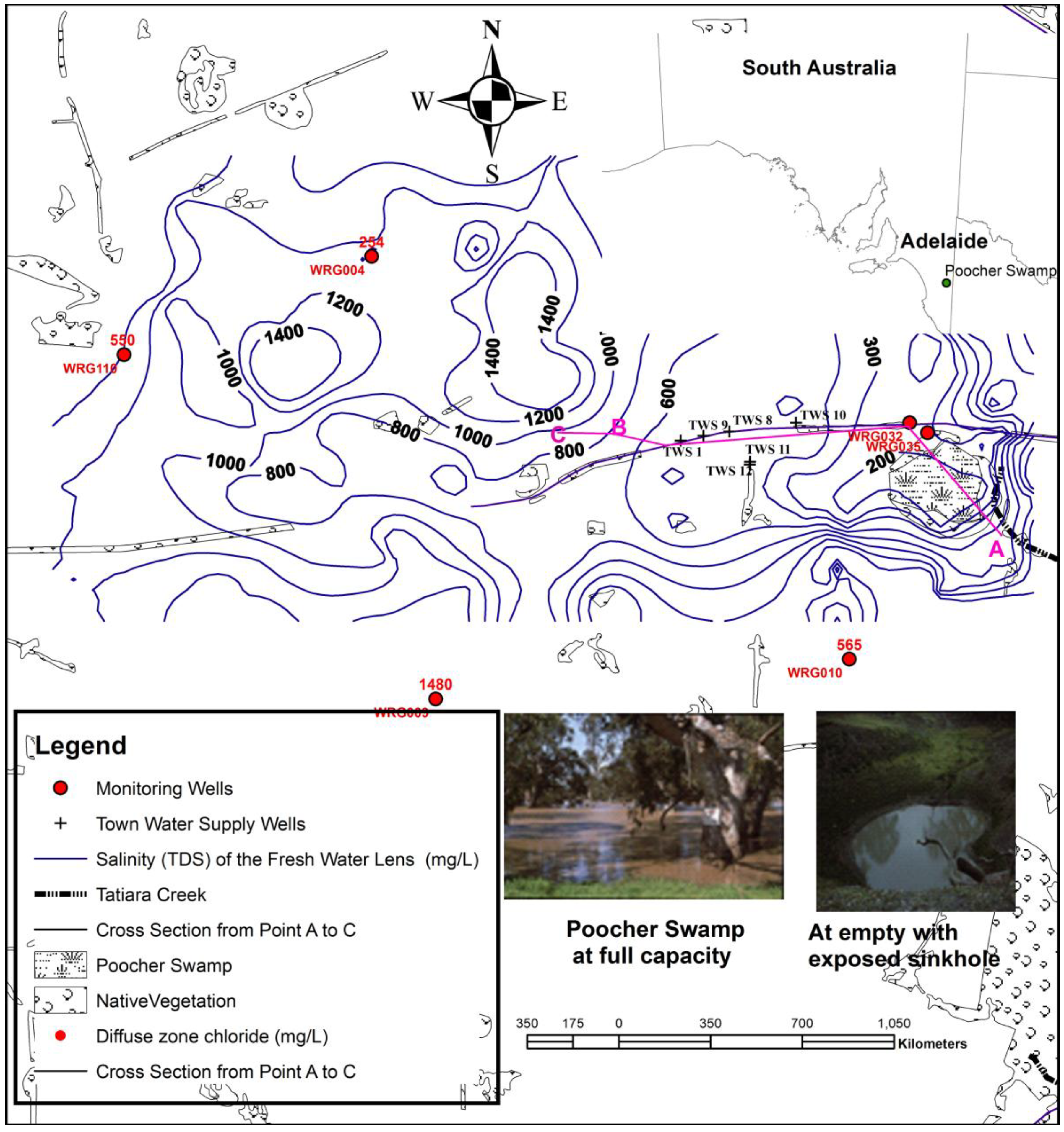
The fourth study site is located in the Tatiara catchment, which extends across the South Australian border into Western Victoria, and features average annual rainfall ranging from 400 to 500 mm and pan evaporation of 2000 mm. The catchment area is approximately 500 km
2 [
16]. The unconfined aquifer is Murray Group Limestone and contains brackish water with average TDS (total dissolved solids) >1400 mg·L
−1, with a chloride concentration of >500 mg·L
−1 [
45] (
Figure 7).
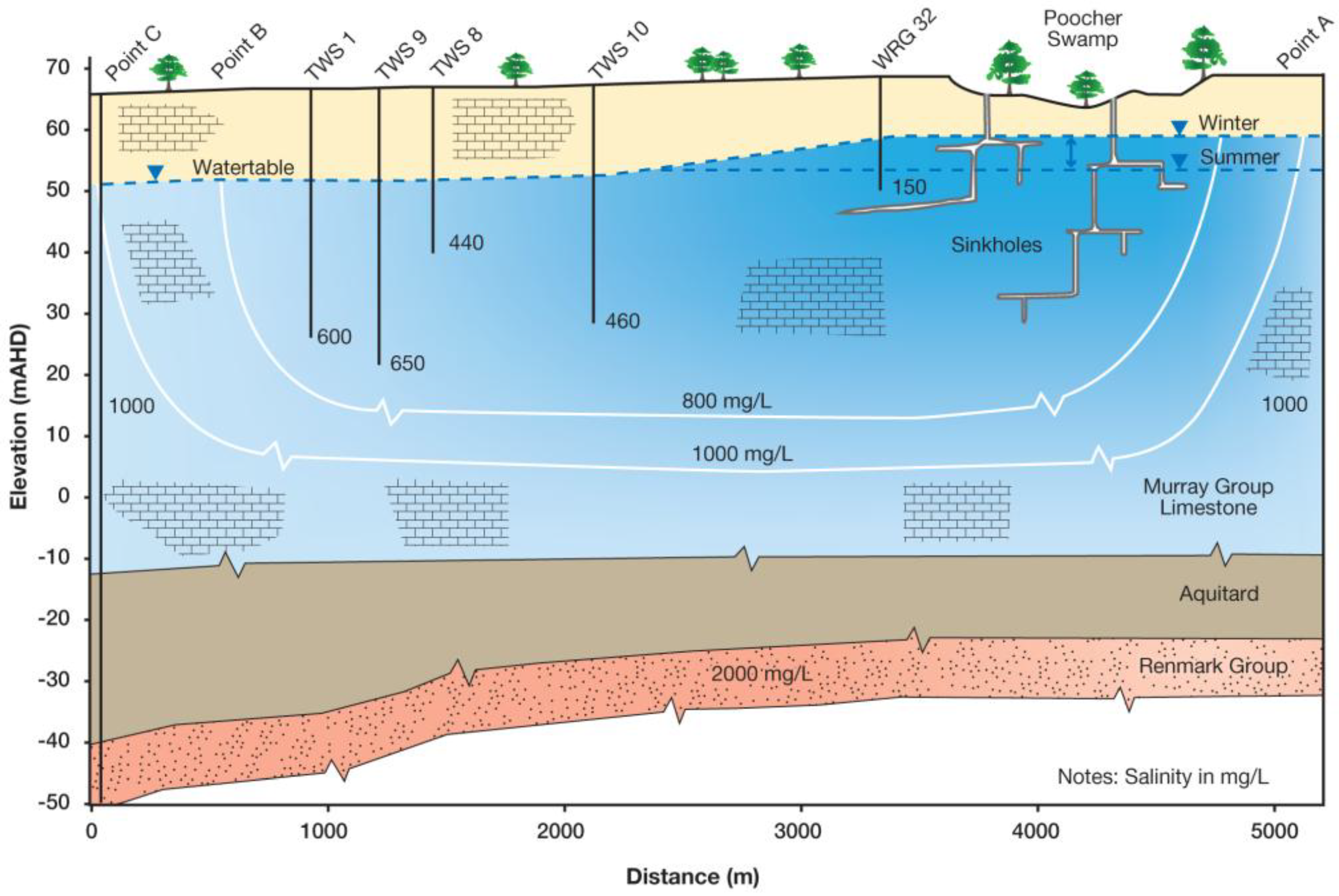
Saturated thickness of the limestone unconfined aquifer is approximately 50–60 m (
Figure 8). Fresh water with TDS <1000 mg·L
−1 occurs at locations where point recharge takes place through sinkholes. Poocher Swamp’s fresh water lens, which is the largest of these fresh water plumes that float on brackish water, is a result of flows from Tatiara Creek that enter Poocher Swamp (
Figure 7). The major recharge is through two sinkholes located in the north-west section of the swamp [
16]. The area encompassed by the 1000 mg·L
−1 salinity contour comprises approximately 20 km
2. This catchment generates irregular annual volumes of freshwater 0.05 × 10
6–2 × 10
6 m
3 per year, but on rare occasion up to 19 × 10
6 m
3 per year. Poocher Swamp is located some 200 km north of Mount Gambier. Groundwater flow direction is from east to west. Currently, an annual volume of 0.6 × 10
6 m
3 of groundwater is extracted from the fresh water lens for town water supply with average salinity 490 mg·L
−1 and chloride concentration of 115 mg·L
−1.
Figure 7.
Poocher Swamp fresh water lens.
Figure 7.
Poocher Swamp fresh water lens.
Figure 8.
Cross section from point A to C in
Figure 7—Poocher Swamp fresh water lens.
Figure 8.
Cross section from point A to C in
Figure 7—Poocher Swamp fresh water lens.
4. Results and Discussion
4.1. Aquifer Water Level Response to Extreme Rainfall Event and Annual Rainfalls in Karst Aquifers
The basic controls on diffuse recharge include climate, vegetation, soils, and topography [
57]. In many settings, diffuse recharge through the soil profile is a relatively slow process. The recharge flux reaching the watertable plane is enriched in salinity and other constituents as a result of evapotranspiration. In contrast, point recharge via sinkholes that are directly connected to the watertable plane is usually of surface water quality, as these fluxes escape evapotranspiration. For shallower water tables, a linear relationship between depth to the water table and water-level response time is evident in granular porosity aquifers [
58]. Typically, connected sinkholes add large volumes of water to the aquifer in a relatively short time, while conduit systems in the aquifer may rapidly transport and remove it leading to short residence time [
24].
This is evident in recent water level responses to an extreme rain event in the Robinson lens, where 109 mm of rainfall was received on 14 February 2014. After allowing a period of two weeks for stability, on 28 February, water levels were monitored in the lens and show on average 0.45 m water level rise, a threefold increase on the long-term average annual watertable rise (
Figure 9). A comparison of water level recovery in the lens is shown in
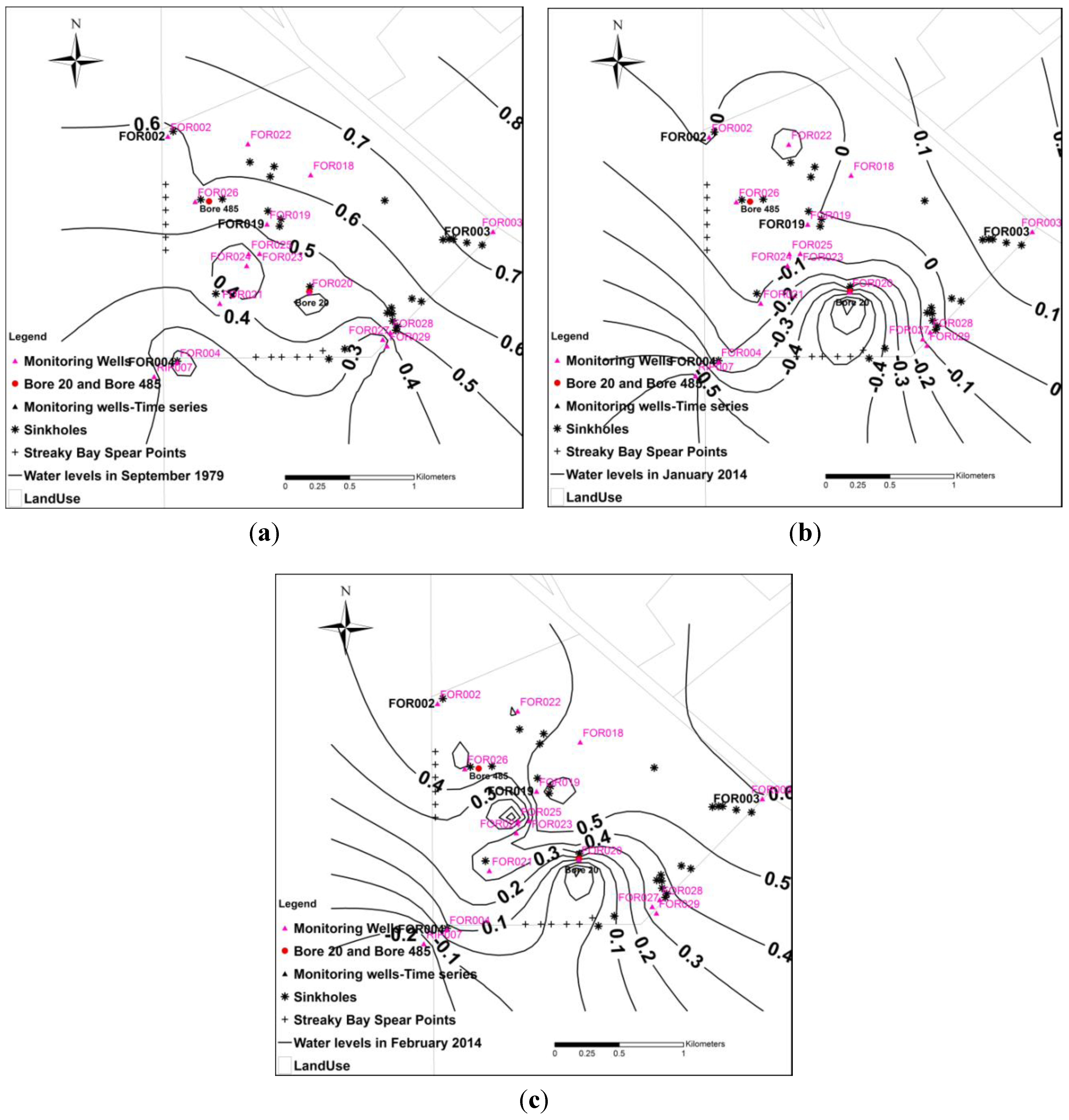
Figure 10. In 1979, groundwater levels ranging from 0.3 m to 0.7 m above sea level of the original groundwater mound existed within the lens (
Figure 10a) and this was depleted to 1.8 m below sea level in 2005. Following a period of no pumping from April 2006–January 2014 water levels recovered by 1.1 m at the lowest point, near pumping well “Bore 20” (
Figure 10b). As a result of the extreme rainfall event on 14 February 2014, the water level further recovered by 0.45 m at the lowest point (
Figure 10c).
Figure 9.
Reduced Standing Water Level (RSWL) fluctuations in the Robinson lens (a) selected hydrographs with inset from March 2013 to May 2015 (b) Air escaping through a fissure in calcrete (macropore) during rapid recharge.
Figure 9.
Reduced Standing Water Level (RSWL) fluctuations in the Robinson lens (a) selected hydrographs with inset from March 2013 to May 2015 (b) Air escaping through a fissure in calcrete (macropore) during rapid recharge.
Figure 10.
Water levels in Robinson lens (a) September 1979 (b) January 2014 (c) 28 February 2014.
Figure 10.
Water levels in Robinson lens (a) September 1979 (b) January 2014 (c) 28 February 2014.
Water level response to annual rainfall is compared in the Uley South basin, a karst aquifer, with the adjacent Coffin Bay lens A, a diffuse recharge aquifer [
31]. Both aquifers adjoin the coast. Depth to water is shallower (3–20 m) in Coffin Bay lens A than Uley South, which is 8–20 m in most locations and greater than 20 m under sand dunes and basin boundaries. Vegetation is sparse in both basins, except on sand dunes. Recharge in Uley South is through karst features (
Figure 3) such as epikarst and sinkholes; and diffuse infiltration and recharge is through pockets of soil that occur in the basin, through the base of the unconnected sinkholes, and at locations where sinkholes have collapsed and filled with sediments. In contrast recharge in Coffin Bay lens A, is by infiltration through sandy surface soil and underlying calcarinite.
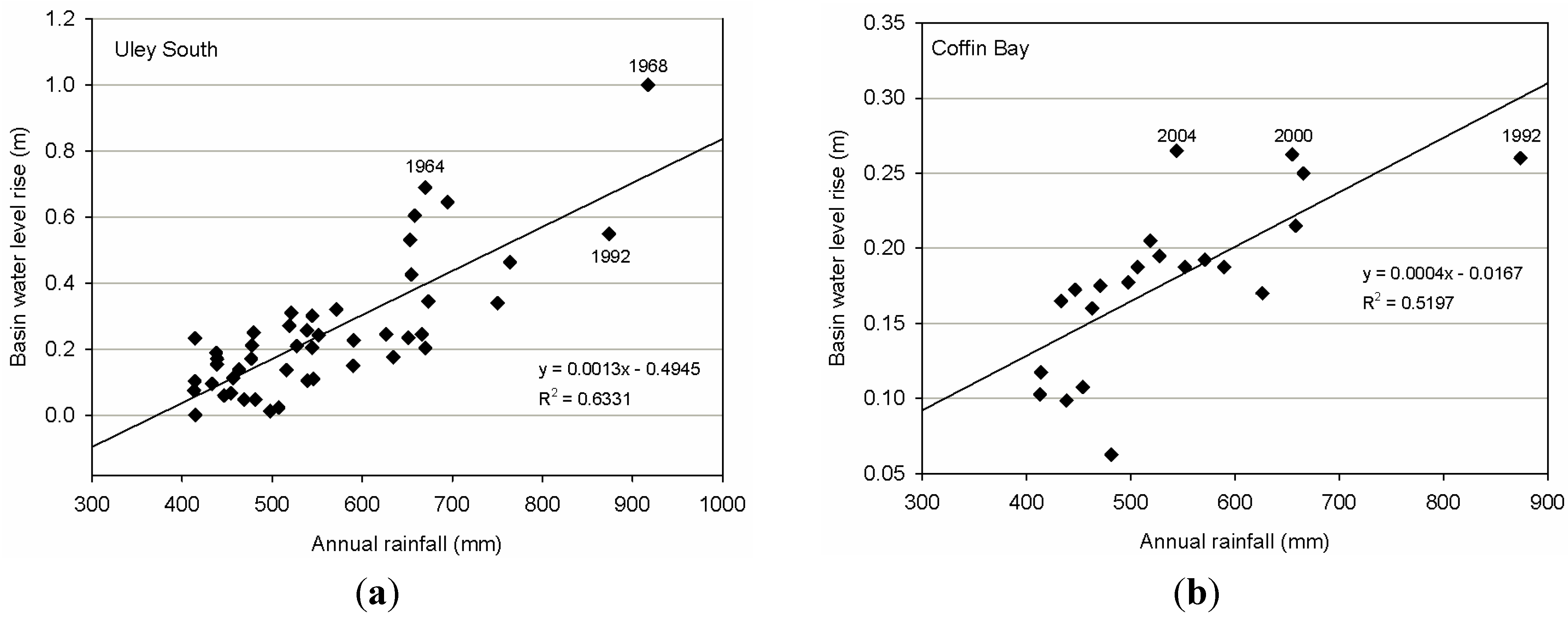
A comparison of average basin water level rise during recharge periods (from April/May to September/October), to annual rainfall is presented for Uley South and Coffin Bay lens A in
Figure 11. Data records from 1960 to 2010 for Uley South, and from 1985 to 2010 for Coffin Bay lens A were used. Rainfall is measured at Big Swamp station, located 18 km east of Coffin Bay, and north-east from Uley South. In both basins, the spatial average of water level response to long-term average annual rainfall (550 mm) is similar, 0.22 m for Uley South and 0.2 m for Coffin Bay lens A. As the annual rainfall increases, the corresponding water level increases rapidly in Uley South. For example, the highest rainfall (917 mm) in the last century occurred in 1968, resulting in 1 m water level rise in the basin. Even though the second highest recorded rainfall (873 mm) occurred in 1992, the water level rise is lower than under the predevelopment conditions in 1964 (669 mm).
Figure 11.
Basin water level response to annual rainfall in Uley South basin and Coffin Bay lens A. (a) Uley South; (b) Coffin Bay.
Figure 11.
Basin water level response to annual rainfall in Uley South basin and Coffin Bay lens A. (a) Uley South; (b) Coffin Bay.
Two factors are considered to have caused this. Firstly, the Uley South basin has established a new equilibrium level, approximately 1 m lower due to groundwater pumping that began in 1976. Secondly, 156 mm of the 1992 rainfall occurred during summer months and the corresponding water level rise is not accounted for, as seasonal water level rise in the recharge period. However, in response to the 59% increase in annual rainfall in 1992 from the annual average, a 150% increase in water level rise was observed. In contrast, the observed increase in water level rise in Coffin Bay in 1992 is about 6%. Thus, recharge in karst aquifers increases as the rainfall-runoff increases, the limiting factor being the amount of rainfall. At the lower end of annual rainfall (380 mm), Uley South basin water level rise is negligible (
Figure 11), but such a lower end could not be confirmed for the Coffin Bay lens A.
Analysis by Evans [
33] suggest a net rise in water level in Uley South requires at least 74%–80% of annual rainfall or at least 10 days of rain greater than 10 mm is required during the period of May to September.
Depending on the intensity of rainfall during the year, monthly monitoring of water level between April and October may not necessarily capture the peak water level. Whilst higher daily rainfall is not necessarily an indication of single large rain event, percentage of rainfall that fell between May to October to annual rainfall; together with percentages of rainfall greater than 10 mm (22%–63%) and 20 mm (0%–31%) of annual rainfall, recorded at Big Swamp station, given in
Figure 12. This indicates 57%–90% of annual rain received in recharge period.
Figure 12.
Characteristics of rainfall.
Figure 12.
Characteristics of rainfall.
Regardless of percentage of rain fell during the recharge period, water level rise decrease rapidly during below average rainfall years (
Table 1). For a given year, about 18%–44% of annual rainfall is comprised of daily rain less than 5 mm, which may evaporate on heavily calretised surface horizons in Uley South basin and Robinson lens.
Evans [
33] observe two types of water level rise in Uley South; an immediate (within hours) short lived, sharp rise after significant rainfall events, followed by a constant decay rate giving a “saw-toothed” shaped hydrograph (as evident in Robinson lens
Figure 9a, inset); and a second type being a gradual rise with low magnitude, delayed up to days or weeks [
33]. The first type of response indicates rapid recharge which would occur through solution features such as sinkholes [
33] and the second type responses due to diffuse recharge processes.
4.2. Groundwater Mixing Zones
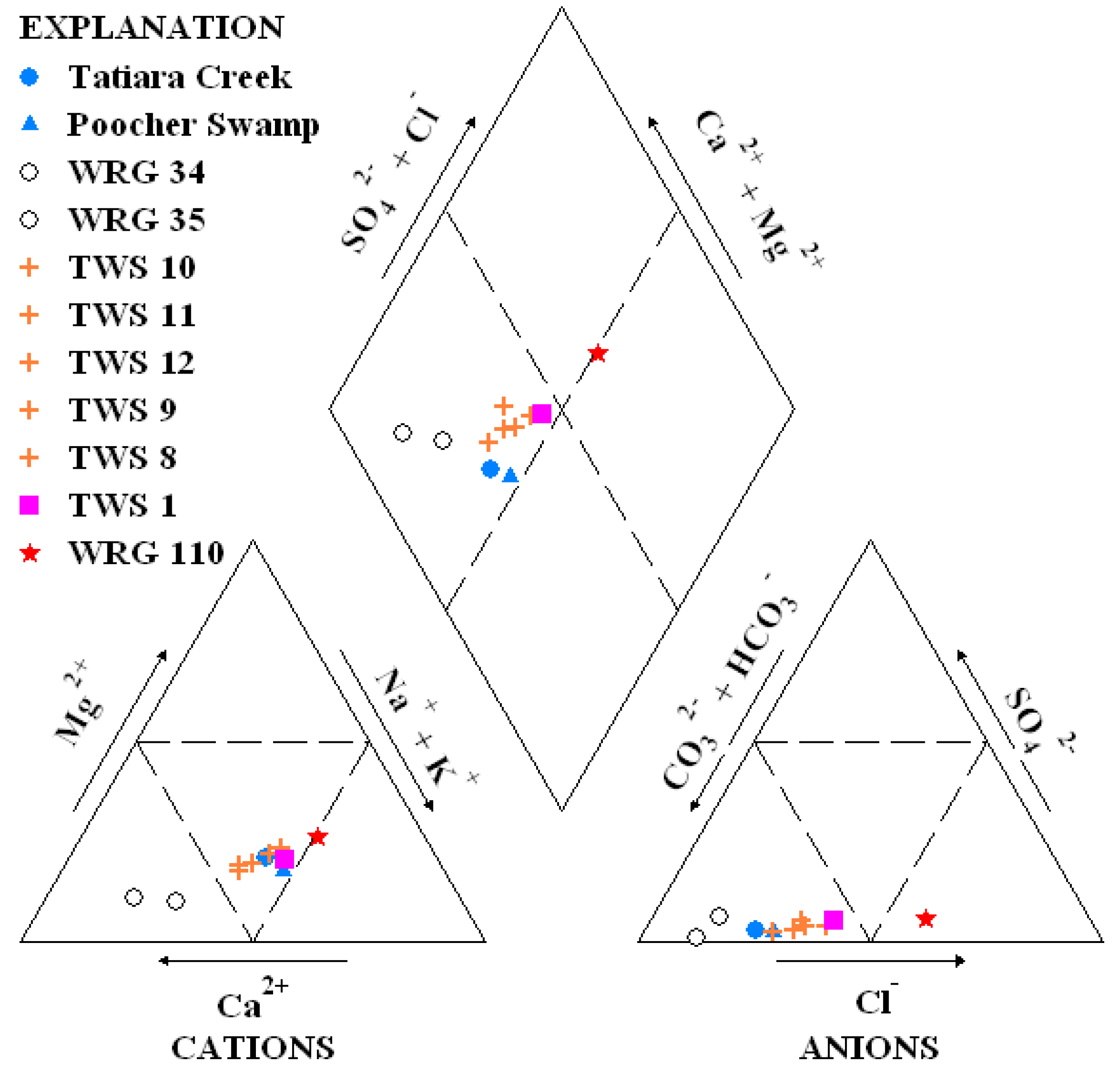
Understanding of the nature and extent of a groundwater mixing zone in a karstic system can help determine the relative importance of non-homogeneity in an aquifer system and its potential impact on the resource estimate. The results of chemical analyses of groundwater in the fresh water lens; from nested monitoring wells WRG 34 and WRG 35 located adjacent to Poocher Swamp, town water supply wells, and a monitoring wells located outside the fresh water lens (
Figure 7); and the surface water samples taken from Tatiara Creek and Poocher Swamp are shown in the Piper diagram (
Figure 13).
Table 1.
Basin average water level response in Uley South to below average annual rainfall.
Table 1.
Basin average water level response in Uley South to below average annual rainfall.
| Year | Annual Rainfall | Recharge Period Rain to Annual Rainfall | Annual rainfall >10 mm of Daily Rain | Annual Rainfall >20 mm of Daily Rain | Basin Average Water Level Rise in Uley South |
|---|
| (mm) | (%) | (%) | (%) | (m) |
|---|
| 1961 | 476 | 88 | 47 | 30 | 0.17 |
| 1962 | 438 | 64 | 32 | 5 | 0.12 |
| 1965 | 437 | 64 | 32 | 5 | 0.19 |
| 1967 | 414 | 85 | 39 | 17 | 0.23 |
| 1969 | 477 | 75 | 43 | 14 | 0.21 |
| 1970 | 469 | 84 | 27 | 0 | 0.05 |
| 1972 | 479 | 72 | 40 | 7 | 0.25 |
| 1977 | 414 | 74 | 30 | 0 | 0.0 |
| 1982 | 456 | 77 | 33 | 20 | 0.11 |
| 1987 | 446 | 81 | 45 | 22 | 0.06 |
| 1988 | 497 | 73 | 46 | 8 | 0.01 |
| 1991 | 414 | 88 | 22 | 0 | 0.1 |
| 1994 | 413 | 71 | 37 | 15 | 0.08 |
| 1997 | 481 | 76 | 50 | 9 | 0.05 |
| 1998 | 433 | 81 | 43 | 11 | 0.1 |
| 2002 | 463 | 77 | 38 | 10 | 0.14 |
| 2006 | 438 | 63 | 58 | 25 | 0.16 |
| 2008 | 471 | 79 | 32 | 10 | 0.16 |
Figure 13.
Piper diagram for fresh water lens.
Figure 13.
Piper diagram for fresh water lens.
The major ion chemistry results show no dominant cations in Tatiara Creek, Poocher Swamp and town water supply (TWS) wells: TWS 10, TWS 8, TWS 9 and TWS 1. However, water chemistry changes from Tatiara Creek (Na-Ca-Mg-HCO3-Cl) and Poocher Swamp (Na-Ca-HCO3-Cl) water types to calcium dominant water: Ca-HCO3 and Ca-Na-HCO3, in WRG 34 and WRG 35 as a result of dissolution of calcite. Except for WRG 110 monitoring well which is chloride dominant, all anions are HCO3 dominant.
All town water supply well water types are either Ca-Na-HCO3-Cl (TWS 10, TWS 9, TWS 8) or Na-Ca-HCO3-Cl ((TWS 11, TWS 12, TWS 1) as a result of different degree of mixing along flow paths between two end member water types in the fresh water lens, which are: Ca-HCO3 in WRG 34 and Na-Mg-Ca-Cl-HCO3 in WRG 110.
This observation is consistent with gradual decrease in δ18O enrichment due to mixing, from Poocher Swamp (−0.34‰ VSMOW-Vienna Standard Mean Ocean Water) to −3.05‰, −3.08‰, −3.23‰ VSMOW at TWS 10, TWS 8, and TWS 9 respectively. Within the fresh water lens, no other significant point recharge sources exist. This indicates that mixing occurs over the distance between point recharge source and ambient regional groundwater, making a non-homogeneous plume. Therefore, as the spatial distribution of chloride concentrations vary due to mixing, it is not possible to obtain representative groundwater chloride that represents either point or diffuse recharge within the plume that cross the watertable plane.
4.3. Preferential Flow Paths
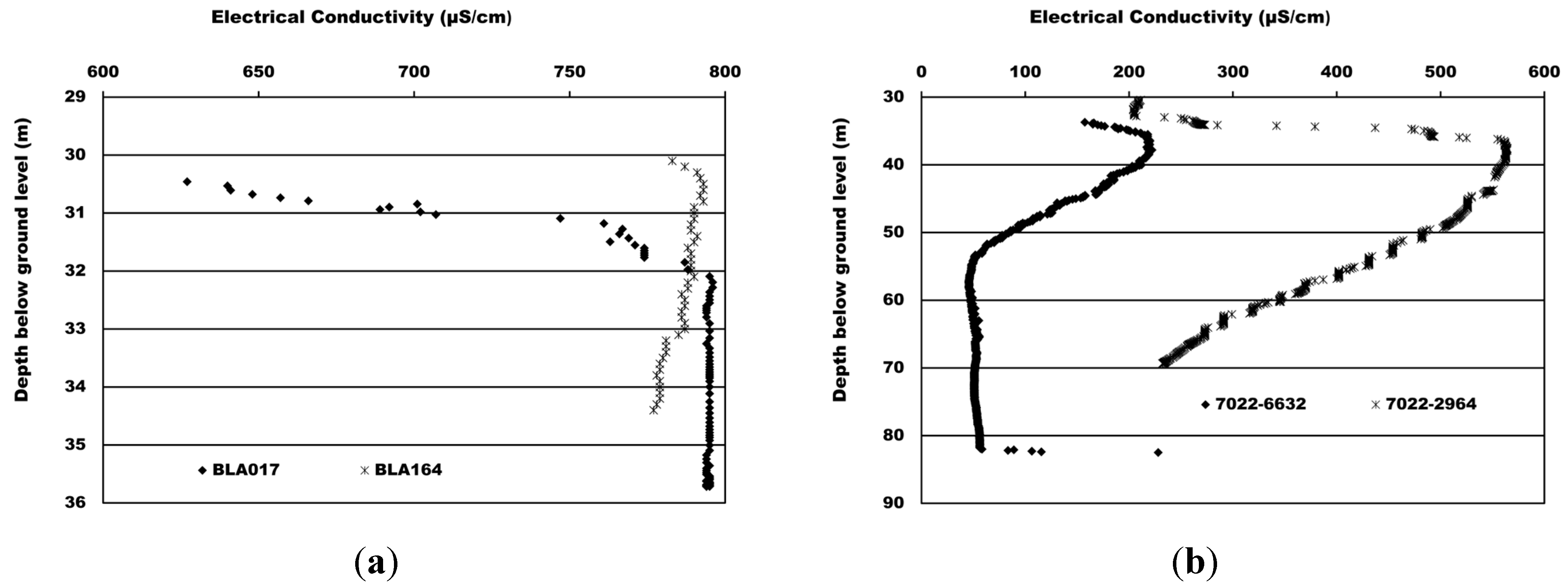
In the Blue Lake capture zone, Mount Gambier, a large variation in measured electrical conductivity (EC) of sub-aquifer groundwater at point recharge locations and diffuse recharge areas is present [
28]. The lowest salinity measured at the deepest aquifer sub-unit which is characterised by extensive fracturing [
28,
41]. Two low salinity (EC) zones (
Figure 14a), indicated by low EC in the profile, are found in monitoring well BLA164 and BLA017 (
Figure 5). The upper low EC zone is due to both diffuse and point recharge to the aquifer. The lower EC zone of BLA164 at 33–34.5 m depth (
Figure 14a) is identified as the primary fracture pathway to Blue Lake [
41]. According to Waterhouse [
38], the presence of solution features, mainly dolines is common, and their concentration south-west of Mount Gambier probably indicates more intensive fracturing. Salinity profiles obtained from drainage wells (
Figure 14b) located in the zone of the primary fracture pathway further south; down gradient to BLA164 confirm that low salinity water moves at greater depth, confirming the Waterhouse [
38] and Lawson [
41] observations. This indicates the existence of preferential groundwater flow pathways at different depths. A similar observation is made by Herczeg
et al. [
16] in their study on Poocher Swamp sinkholes. Three monitoring wells were used at 10 m, 50 m and 150 m down-gradient of the two sinkholes to study water level behaviour during recharge. The first two wells were completed shallow, 6 m below water level, and the third one (at 150 m) was completed at 50 m depth and about 35 m below water level. Maximum water level rise had been observed at the well 150 m from the sinkholes indicating direct sub-surface connectivity to the sinkholes.
Overall, these results show the complex nature of tracking flow paths in karst, and the non-homogeneity at point recharge sources, aquifer monitoring wells, and along flow paths. As the conduit flow carries freshly recharged water from point sources, it may not be possible to obtain representative groundwater chloride as an input to the conventional CMB.
Figure 14.
Salinity profiles (a) Monitoring wells (b) Drainage wells.
Figure 14.
Salinity profiles (a) Monitoring wells (b) Drainage wells.
4.4. Characteristics of Point Recharge—Chloride to δ18O Relation
In their study of Uley South basin, Ordens
et al. [
35] used the chloride
vs. δ
18O relationship to determine relative contribution of point recharge to total recharge. These authors argued that the contribution to recharge by flow through sinkholes is only a small fraction of total recharge. This conclusion is based on a lack of intermediate data points between groundwater chloride and rain water chloride in the chloride
vs. δ
18O plot (
Figure 15b) [
35]. In
Figure 15, chloride
vs. δ
18O plots are given for the Robinson lens, Uley South, Blue Lake capture zone at Mount Gambier and Poocher Swamp freshwater lens in the Tatiara catchment [
36]. The widest gap between groundwater chloride and rain water chloride is about 250 mg·L
−1 in the Robinson lens where average annual rainfall is lowest, followed by 83 mg·L
−1 in the Uley South aquifer (
Figure 15a,b). In the Blue Lake capture zone where average annual rainfall is 160 mm greater than Uley South, a gap of 43 mg·L
−1 exists, even with a high number of point recharge sites, principally through the 400 drainage wells directly recharging the aquifer [
28]. Intermediate data points between rainfall and groundwater chloride can be obtained via chloride measurements taken at drainage wells, which are discrete recharge points (
Figure 15c). In Poocher Swamp in the Tatiara catchment, the freshwater lens of 7 to 10 km length developed due to the high volume of annual creek flow recharging the limestone aquifer [
29]. The fresh water plume intercepted by a number of measurement points shows that there are no gaps between surface water and groundwater chloride (
Figure 15d) at the nearest measurement point.
Lack of intermediate data points [
35] may result from monitoring bias. A number of factors influence this observation: aquifer water level monitoring wells not necessarily near sinkholes or located outside the small pockets of fresher inflow associated with sinkholes; difficulty in obtaining groundwater samples from sinkholes due to their complex architecture and the unknown extent of conduit in saturated zone; small catchments contributing to sinkholes not generating sufficient runoff volume to develop fresh water plumes to reach measurement points; fresh recharge water from point sources occupying a small cross sectional area compared to granular porosity areas and carried away by conduit flows; intermittent and transient nature of point recharge; and non-uniform mixing of granular porosity water with point recharge water. Therefore, a lack of intermediate data points between rainfall and most groundwater does not discount point recharge.
Figure 15.
Chloride vs. 18O for point recharge dominant groundwater basins (a) Robinson lens (b) Uley South (c) Mount Gambier Blue Lake capture zone (d) Poocher Swamp fresh water lens.
Figure 15.
Chloride vs. 18O for point recharge dominant groundwater basins (a) Robinson lens (b) Uley South (c) Mount Gambier Blue Lake capture zone (d) Poocher Swamp fresh water lens.
4.5. Comparison of Conventional CMB Estimated Recharge with Recharge Estimation by Watertable Fluctuation (WTF) Method, Groundwater Modelling and Point Recharge
The conventional CMB method is frequently used for recharge estimation and is given by [
25,
26,
27]:
where R (mm/year) is average annual recharge, P (mm·year
−1) is average annual rainfall (mm), c
p+D (mg·L
−1) is representative mean chloride concentration of rain water including contributions from dry deposition [
35] and c
g (mg·L
−1) is chloride concentration in groundwater. In the absence of direct measurement, the c
p+D can be estimated from Hutton [
59] using:
where “d” is distance in km from the ocean in the prevailing wind direction. Thus, for Uley South at 6 km from coast to the centre of the basin gives c
p+D of 14.3 mg·L
−1; for Mount Gambier at 20 km from the coast, c
p+D of 8.5 mg·L
−1 and for the Poocher Swamp at 100 km from the coast produce c
p+D of 3 mg·L
−1.
For the four case studies described in this paper, the conventional CMB is applied in a manner similar to Ordens
et al. [
35] to estimate recharge. For application of conventional CMB to estimate total recharge, an average chloride concentration in the fresh water lens of 91 mg·L
−1 was used for the Poocher Swamp fresh water lens, while for Mount Gambier, 63 mg·L
−1 was used. For the estimation of diffuse recharge, average chloride concentration for diffuse recharge zones were taken from
Figure 3a for Uley South (149 mg·L
−1), from
Figure 5 for Mount Gambier (63 mg·L
−1), and from
Figure 7 for Poocher Swamp (712 mg·L
−1).
Based on the annual flow of Tatiara Creek for the period 1980–2010, average annual recharge to groundwater in Poocher Swamp is taken as 2.5 × 10
6 m
3 through the two sinkholes. A similar estimate of about 2.3 × 10
6 m
3 was made by Stadter and Love [
60] in 1987. As part of the recharge estimation for the Blue Lake in Mount Gambier [
31], Nguyen [
61] used the urban storm water model MUSIC [
62] for quantifying storm water runoff to drainage wells. In the study, rainfall and runoff process was modelled for the period 2007–2012 using a daily time step with daily rainfall and evaporation data. For the average annual rainfall of 750 mm, Nguyen [
61] estimated 6.6 × 10
6 m
3 of runoff volume, equivalent of 390 mm per year, flows through drainage wells to groundwater from a catchment area of 16.8 km
2.
In Uley South basin, Ward
et al. [
63] used LEACHM [
64], a variably saturated model of the soil profile that uses the curve number approach described by Williams [
65] to estimate surface runoff to sinkholes. This resulted in a point recharge component alone that was greater than the estimated recharge using conventional CMB (
Table 2). Since total recharge is a combination of both, point and diffuse recharge components, these results clearly indicate that the conventional CMB is underestimating actual total recharge when point recharge is a contributing factor. Application of conventional CMB to estimate recharge to the Poocher Swamp fresh water lens requires further consideration.
Table 2.
Comparison of recharge estimates with point recharge.
Table 2.
Comparison of recharge estimates with point recharge.
| Recharge estimation method | Average annual recharge (mm per year) |
|---|
| Robinson Lens | Uley South Basin | Mount Gambier | Poocher Swamp |
|---|
| Diffuse recharge from the Conventional CMB | - | 52.7 | 101 | 1.8 |
| Point recharge | - | 75 [63] | 390 [28,61] | 127 [60] |
| Total recharge from the Conventional CMB | 7.6 [31] | 53–60 [35] | 101 | 14 |
| Total recharge from WTF method | 38 [31] | 129 [35] | - | - |
| Total recharge from Groundwater models | 27 [31] | 146 [66] | - | - |
Martin and Screaton [
67] recognise that karst aquifer systems comprise of two components, in which a majority of the storage occurs within the matrix porosity of the diffuse system, while the majority of transport occurs in the small cross-sectional area of fractures and dissolution conduits. Thus, even if an extensive monitoring network is established, the tendency is to monitor long-term resident chloride concentration of matrix porosity as evident in Uley South basin and Mount Gambier Blue Lake capture zone. Therefore, the estimated diffuse recharge component and the total basin recharge using the conventional CMB are similar in magnitude, but significantly lower than recharge estimated using WTF method and by groundwater modelling. It is perceived that simplified assumptions in the conventional CMB and the inability to obtain representative chloride concentrations make direct application of the conventional CMB method to point recharge dominant groundwater basins questionable. Therefore, there is nothing to be gained by further improving data for application of the conventional CMB [
31]. For recharge estimation in point recharge dominant basins, watertable fluctuation, numerical groundwater modelling, Darcy flow calculation or water budget methods are more suitable as these methods are independent of the particular mode of recharge [
31].
Average chloride concentration in the Poocher Swamp fresh water lens of 91 mg·L−1 or a recharge value of 14 mm per year are not representative of recharge to the lens. In fact vertical recharge (1.8 mm·year−1) that crosses the watertable plane corresponds to a diffuse zone groundwater chloride concentration of 712 mg·L−1 outside the lens. The fresh water lens’s recharge water is generated outside the plume area. Low salinity and chloride concentrations found in the fresh water lens results from a lateral flux moving from point source recharge down gradient. Taking chloride measurements from a lateral flux to estimate vertical recharge is essentially estimating “apparent recharge”. This is because the estimated recharge never crossed the watertable plane at the location.
5. Conclusions
Understanding of recharge mechanisms and reliable recharge estimates are critical to evaluation and management of water resources. Reliability of estimated recharge depends largely on applicability of the particular method employed, availability of reliable data and adequate spatial coverage of data for the basin [
31]. While knowledge of long-term average recharge rates is beneficial to groundwater managers, in karst aquifers recharge estimation using average annual rainfall can miss the high recharge yielded from above average rainfall. Many methods have been developed for estimating recharge at different spatial and temporal scales [
4]. Methods such as watertable fluctuation or numerical modelling are independent of the mode of recharge processes; problems arise in maintaining the assumptions of the conventional CMB in karst aquifers. This is because the conventional CMB requires assumption of a steady-state chloride mass flux crossing the watertable plane [
26,
27] but point recharge is highly transient; further, application of the conventional CMB to karst aquifers uses long-term average rainfall as an input, but high levels of recharge occur due to above average rainfalls; and thirdly, there is difficulty in specifying representative long-term average chloride concentrations for groundwater due to the presence of conduit flow and occurrence at differing depths, along with different mixing zones of fresher water pockets or plumes around point recharge sources. In many cases, small fresher water pockets may also be transient. In this regard, Subayani and Sen [
68] show that the conventional CMB is valid under less variable systems under steady-state conditions; otherwise the conventional CMB should be viewed as an over simplification. Thus in karst aquifers the reliability of the conventional CMB is questionable as the underpinning assumptions of the conventional CMB equation do not hold.
The paper presents case studies showing that karst systems have a distinct hydrologic function resulting from a duality of flow regimes in infiltration and recharge, and in preferential groundwater flow paths. This study contrasts the suggestion that the presence of a measured gap between groundwater and rainwater chloride in the chloride vs. δ18O plot, is indicative of sinkholes only indirectly recharging the aquifer. This is evident in a recent recharge response to an extreme rain event in the Robinson lens. Non-homogeneity exists at point recharge sources and along flow paths. Given that the extent of fresh water pockets at point recharge locations and along conduits may not be entirely known, it may not be possible to obtain representative salinity or chloride samples for groundwater systems when point recharge is a contributing factor.
