Historical and Technical Notes on Aqueducts from Prehistoric to Medieval Times

 ,
, 
Abstract
:1. Introduction
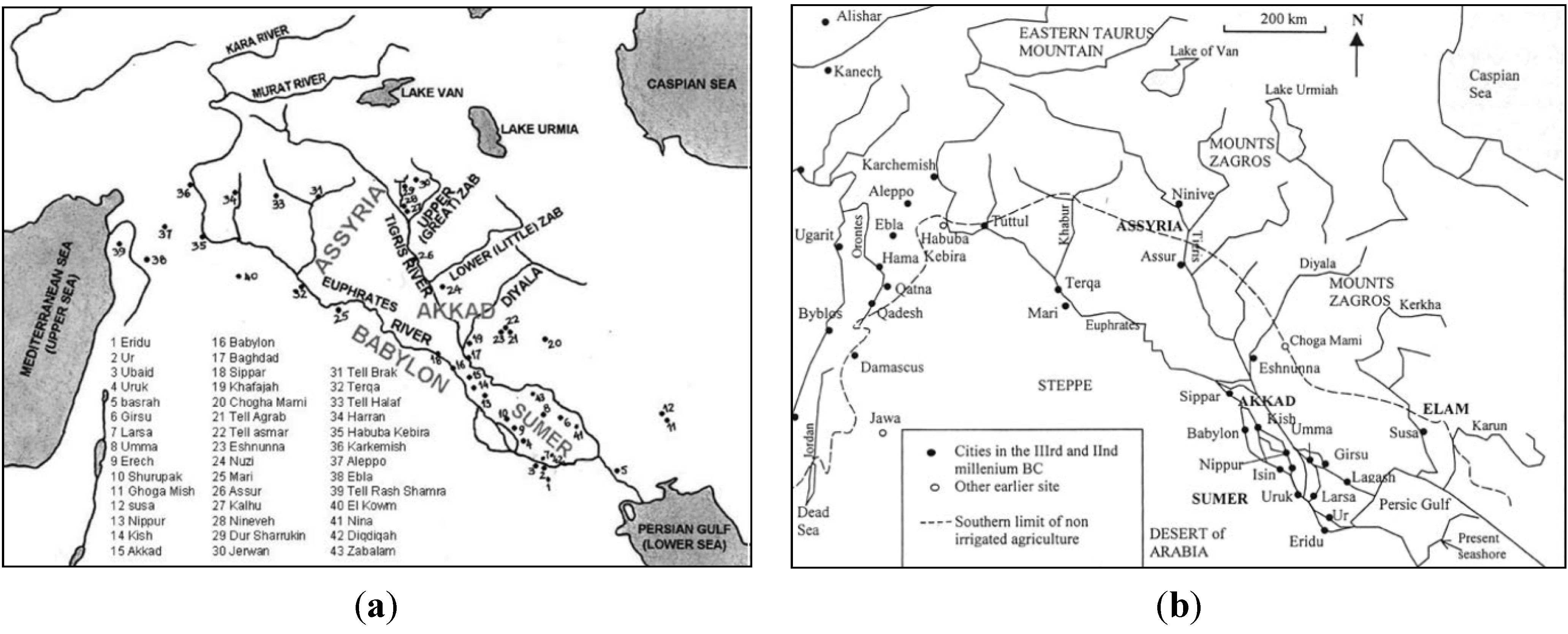
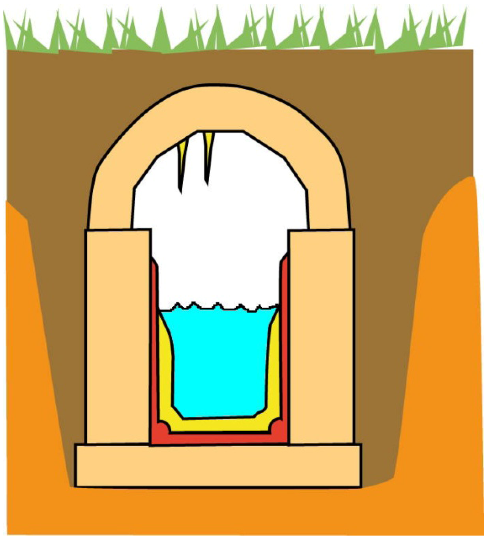
2. Mesopotamia and Ancient Crete (ca. 3300–1100 BC)


| Source of water | Cities, settlements or palaces |
|---|---|
| Short canal connected to permanent river | Uruk, Ur, Babylon (cities in the Tigris andEuphrates valleys) |
| Canals and reservoirs storing flood water of non-permanent river, rainfall | Khirbet el Umbashi (Syria) |
| Rainwater harvesting (gutters and cisterns) | Aghia Triada, Chamaizi, Knossos, Myrtos Pygros, Phaistos, and Zakros (Crete) |
| Wells | Ugarit (Syria) |
| Aqueducts from source at altitude | Knossos, Mallia, and Tylissos (Crete), Chogha Zanbil (Iran) |
| Underground cisterns | Zakros and Tylissos (Crete) |
| Springs | Knossos and Tylissos (Crete) |
| Aqueduct name | Location | Construction | Reconstruction | Length (km) |
|---|---|---|---|---|
| Gournia | Faneromeni, Asari | Minoan | - | 7 |
| Karphi | Karphi, Lassithi | Minoan | - | not available |
| Knossos (Mavrokolympos) | Knossos | Minoan | Roman | 0.7 |
| Malia | Profitis Ilias, Malia | Minoan | Hellenistic, Roman | 0.85 or 1.15 |
| Mochlos | Mochlos, Lassithi | Minoan | - | 3 |
| Tylissos | Tylissos | Minoan | - | 1.4 |
3. Ancient Egypt (ca. 3000–67 BC)

4. Indus Valley Civilization (ca. 2600–1900 BC)
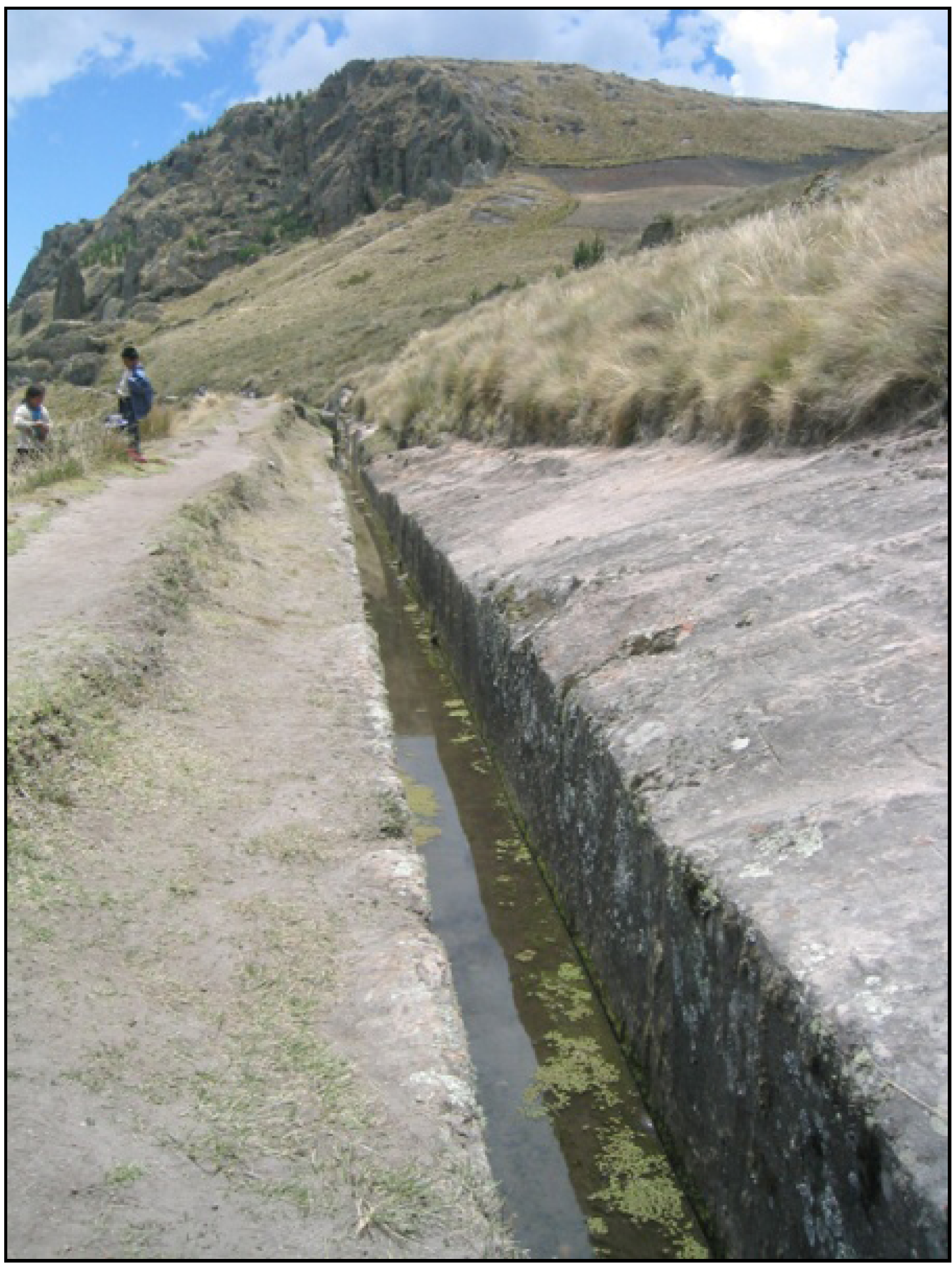
5. Pre-Columbian Cultures (ca. 2600 BC–Early 16th Century AD)
6. Historical Times
6.1. Chinese Dynasties and Empires (ca. 770 BC–1911 AD)
6.2. Hittite Empire (ca. 1700–1180 BC)
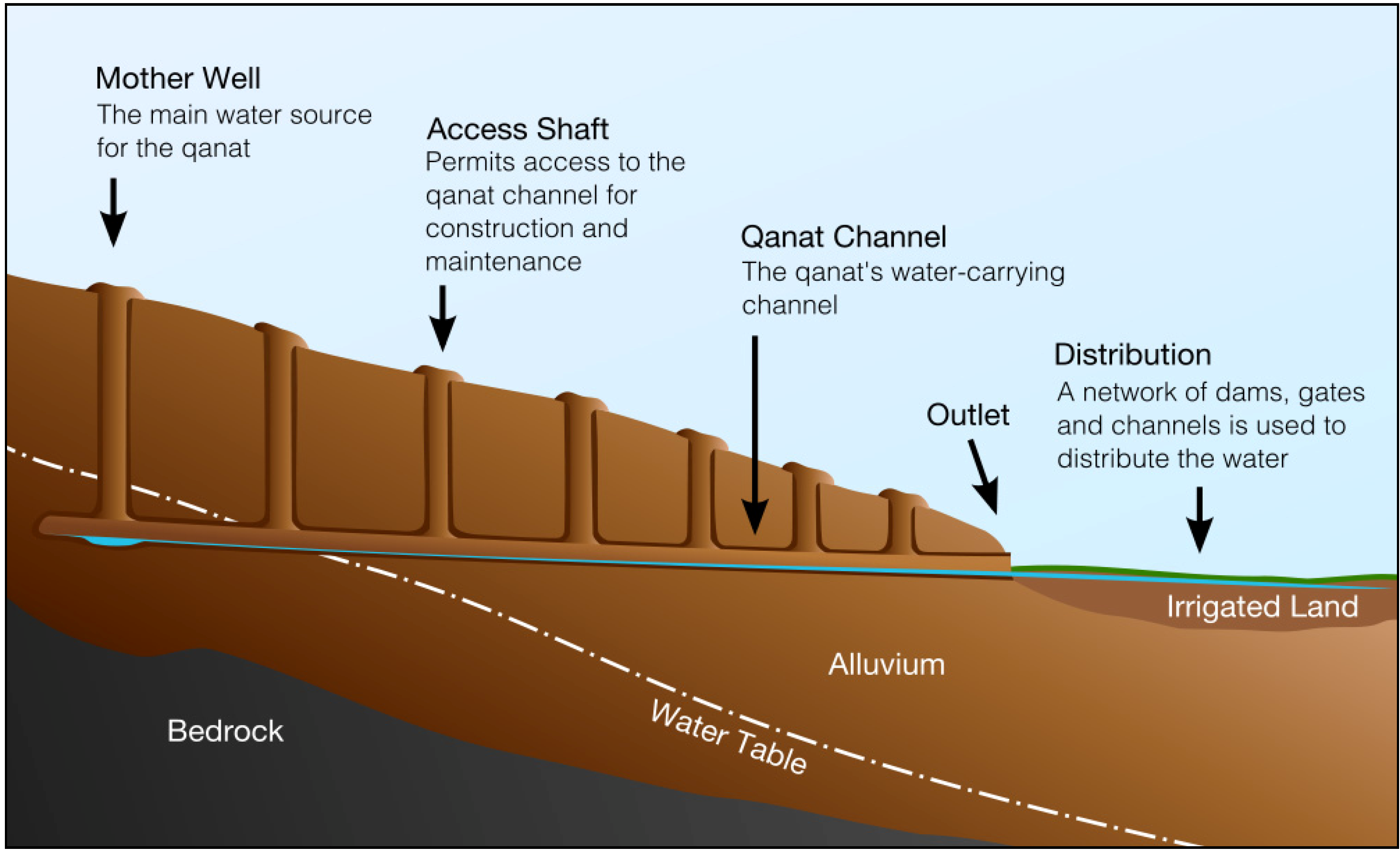
6.3. Urartu Kingdom (ca. 1000–700 BC)
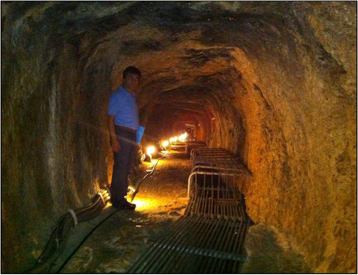
6.4. Persian Empire (550–331 BC)
6.5. Etruscan Civilization (ca. 800–100 BC)
6.6. The Classical and Hellenistic Periods (ca. 480–67 BC)

| Aqueduct name | Location | Period | Age of construction | Length (km) | Flow rate (m3d−1) |
|---|---|---|---|---|---|
| Naxos | Naxos, Greece | Classical | 6th century BC | 11.0 | - |
| Peisistratean (terracotta pipes in shallow trench, qanat-fashion) | Athens, Greece | Classical | Late 6th century BC | - | - |
| Eupalinos | Samos, Greece | Classical | 530–520 BC | 28 | - |
| Hymettos (tunnel and wells up to 14 m deep, qanat-fashion) | Athens, Greece | Classical | Late 5th or early 4th century BC | 6.5 | |
| Acharnian (elliptical terracotta tubes in shallow trench, qanat-fashion) | Athens, Greece | Classical | Early 4th century BC | 19.5 | |
| Long Walls aqueduct (shallow tunnel and wells, qanat-fashion) | Athens, Greece | Unknown | Unknown | ~9 | |
| Paggaio Mountain 1 | Greece | Classical | 4th century BC | 14 | - |
| Paggaio Mountain 2 (qanat-fashion) | Greece | Classical | 4th century BC | 20 | - |
| Polyrrhenia 1 (qanat-fashion) | Polyrrhenia, Crete | Classical | 4th century BC | ||
| Polyrrhenia 2 (qanat-fashion) | Polyrrhenia, Crete | Classical | 4th century BC | ||
| Attalos | Turkey | Hellenistic | - | 15 | - |
| Demophon | Turkey | Hellenistic | - | - | 1,500 |
| Madradag | Pergamon, Turkey | Hellenistic | 200–190 BC | 50 | 40,000 |
6.7. Nabataean and Hasmonean Aqueducts
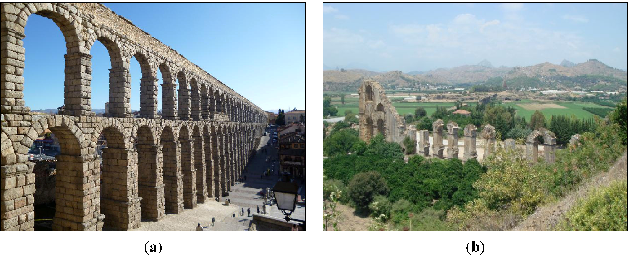
6.8. Roman Period


| Aqueduct name | Location | Period | Age of construction | Length (km) | Flow rate (m3 d−1) |
|---|---|---|---|---|---|
| Cherchell | Algeria | Roman | - | >45 | 6,600–40,000 |
| Cuicul | Algeria | Roman | - | 5–6 | - |
| Gunugu | Algeria | Roman | - | - | - |
| Arles | France | Roman | 1st century AD | 48.0 | 8,000 |
| Beaulieu (Aix-en-P.) | France | Roman | - | - | - |
| Brévenne (Lyon) | France | Roman | 1–50 AD | 70.0 | 10,000 |
| Gier (Lyon) | France | Roman | 50 AD | 75.0 | 15,000 |
| Gorze (Metz) | France | Roman | 100–200 AD | 22.3 | - |
| Mons (Fréjus) | France | Roman | 100–200 AD | 39.4 | - |
| Mont d’Or (Lyon) | France | Roman | 40 BC | 26.0 | 2,000–6,000 |
| Montjeu (Autun) | France | Roman | - | - | - |
| Nîmes | France | Roman | 41–54 AD | 49.8–50.0 | 35,000 |
| Yzeron-Craponne (Lyon) | France | Roman | 20–10 BC | 40.0 | 13,000 |
| Cologne | Germany | Roman | - | 95.4 | - |
| Hadrianean (Athens, tunnel and wells up to 40 m deep ) | Hellas | Roman | 125–140 AD | 19.8 | - |
| Chersonisos | Hellas | Roman | First half of the 2nd century AD | 13 | - |
| Corinth (Stymfalia) | Hellas | Roman | 125–160 AD | 85.0 | 80,000 |
| Elyros | Crete, Hellas | Roman | - | 2 | - |
| Gortys | Crete, Hellas | Roman | Late Roman | 15 | - |
| Lyttos | Hellas | Roman | 33 BC–14 AD | 22 | - |
| Minoa (Chania) | Crete, Hellas | Roman | 2nd century AD | 1.77 | - |
| Moria | Lesvos, Hellas | Roman | End of 2nd or beginning of 3rd century AD | 26 | - |
| Rhodos (qanat-fashion) | Hellas | Roman | - | - | - |
| Anio Novus (Rome) | Italy | Roman | 52 AD | 86.876 | 189,520 |
| Anio Vetus (Rome) | Italy | Roman | 273 BC | 63.640 | 175,920 |
| Aqua Alexandrina (Rome) | Italy | Roman | 226 AD | 22.000 | 21,025 |
| Aqua Alsietina (Rome) | Italy | Roman | 2 BC | 32.882 | 15,680 |
| Aqua Appia (Rome) | Italy | Roman | 312 BC | 16.561 | 73,000 |
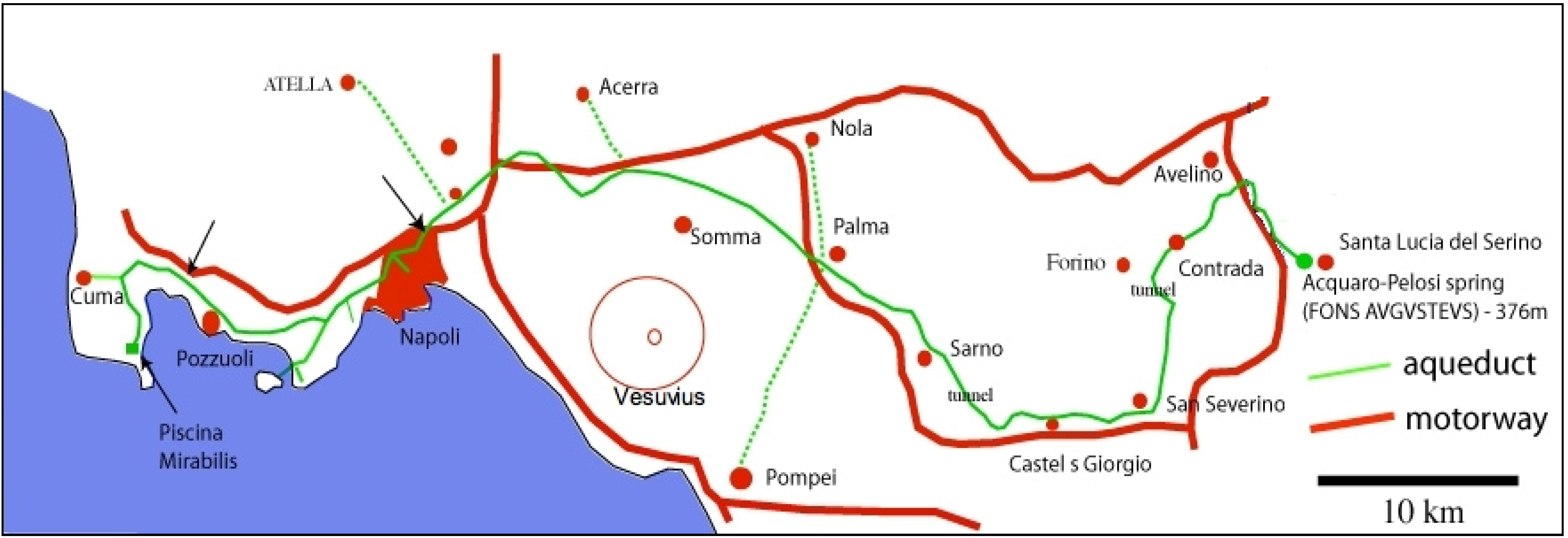
| Aqua Augusta (Serino) | Italy | Roman | 33–12 BC | 140.0 | 47,520 |
| Aqua Claudia (Rome) | Italy | Roman | 52 AD | 68.977 | 184,280 |
| Aqua Julia (Rome) | Italy | Roman | 33 BC | 22.830 | 48,240 |
| Aqua Marcia (Rome) | Italy | Roman | 144 BC | 91.331 | 187,600 |
| Aqua Tepula (Rome) | Italy | Roman | 127 BC | 17.800 | 17,800 |
| Aqua Trajana (Rome) | Italy | Roman | 109 AD | 58.000 | 113,100 |
| Aqua Virgo (Rome) | Italy | Roman | 19 BC | 20.875 | 100,160 |
| Carthage | Tunisia | Roman | 160 AD | 132.0 | 17,280 |
| Dougga | Tunisia | Roman | - | 12 | - |
| Patara | Turkey | Roman | 100 AD | 25 | - |
| Italica (Trajan) | Spain | Roman | 1st century AD | - | - |
| Apamea | Syria | Roman | 1st century AD | 150 | 43,000 |
| Kaystros (Ephesus) | Turkey | Roman | 2nd century AD | 40 | 9,000–35,000 |
| Italica (Hadrian) | Spain | Roman | 2nd century AD | - | - |
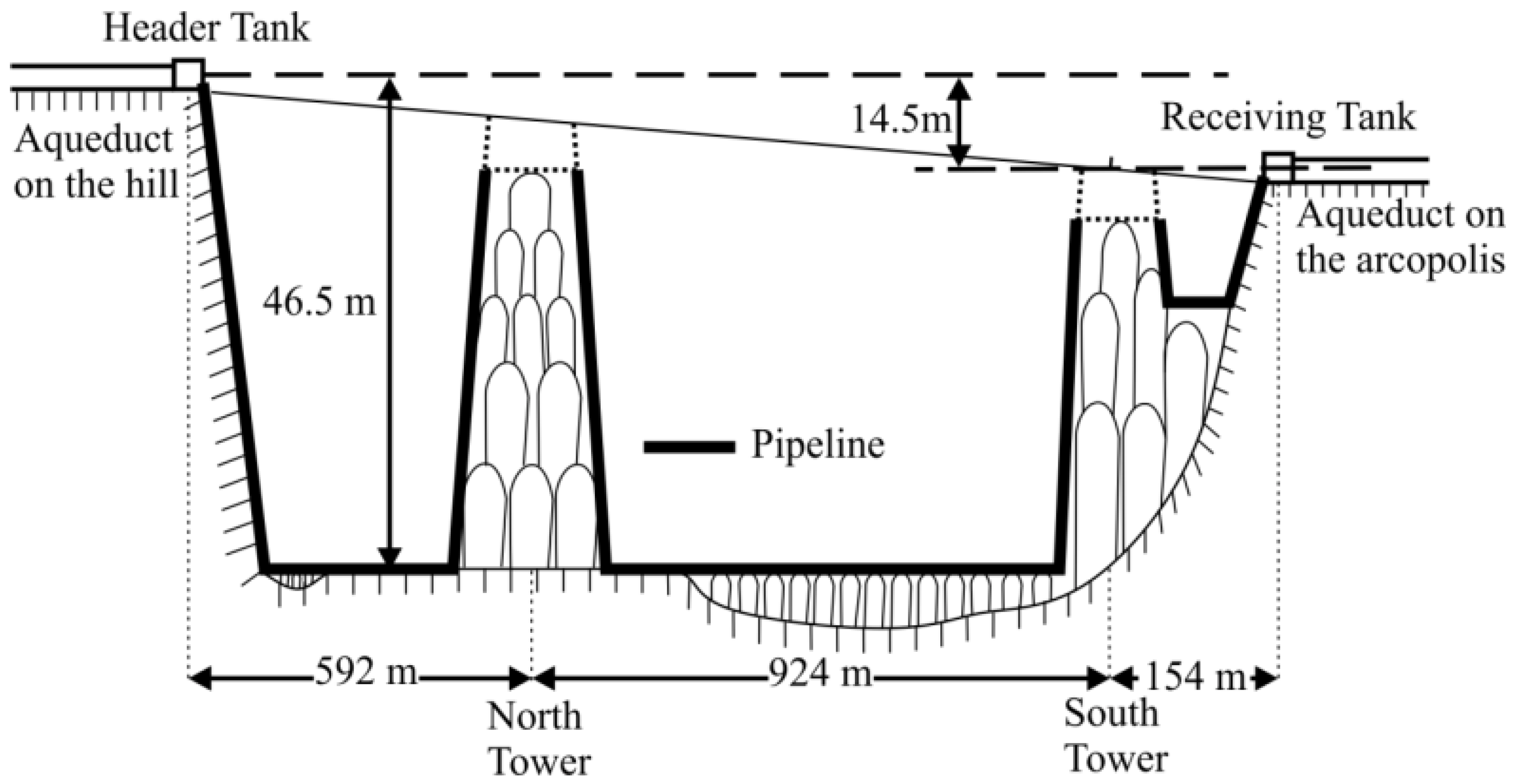
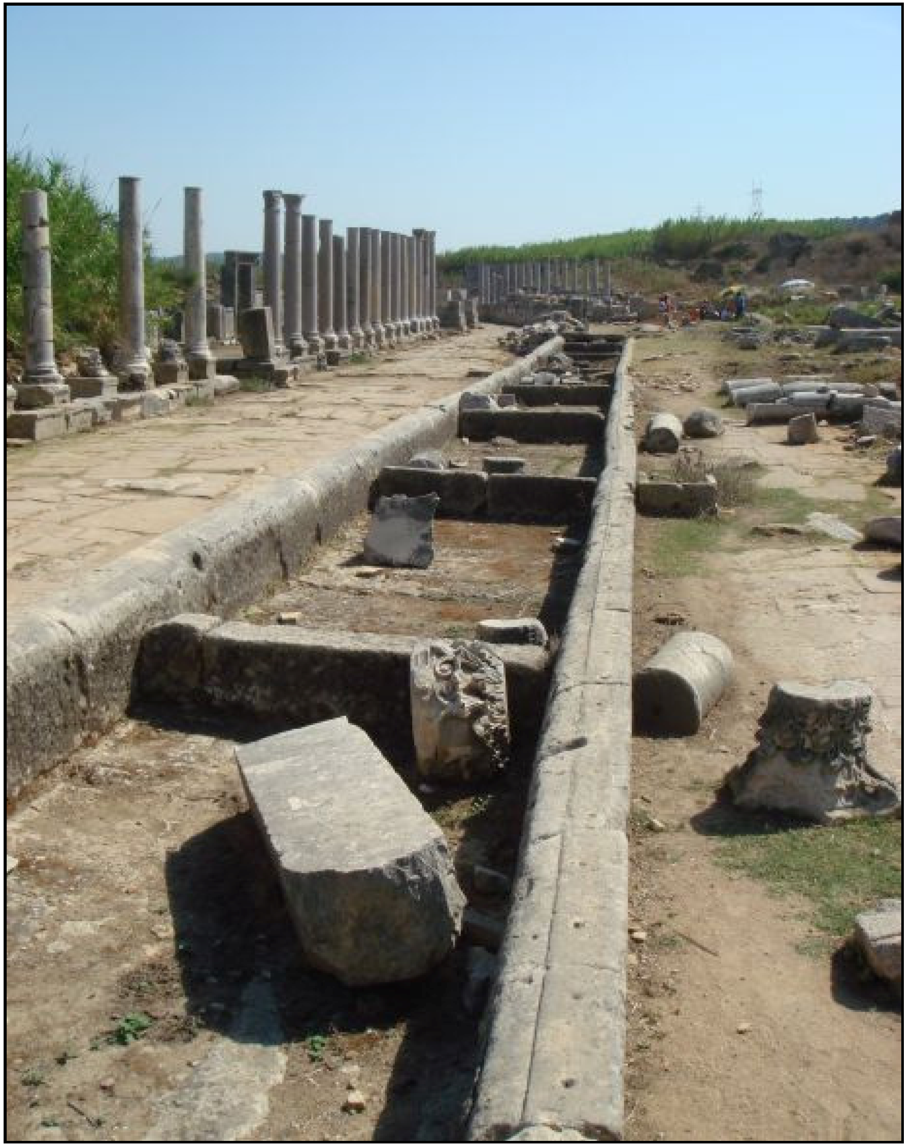
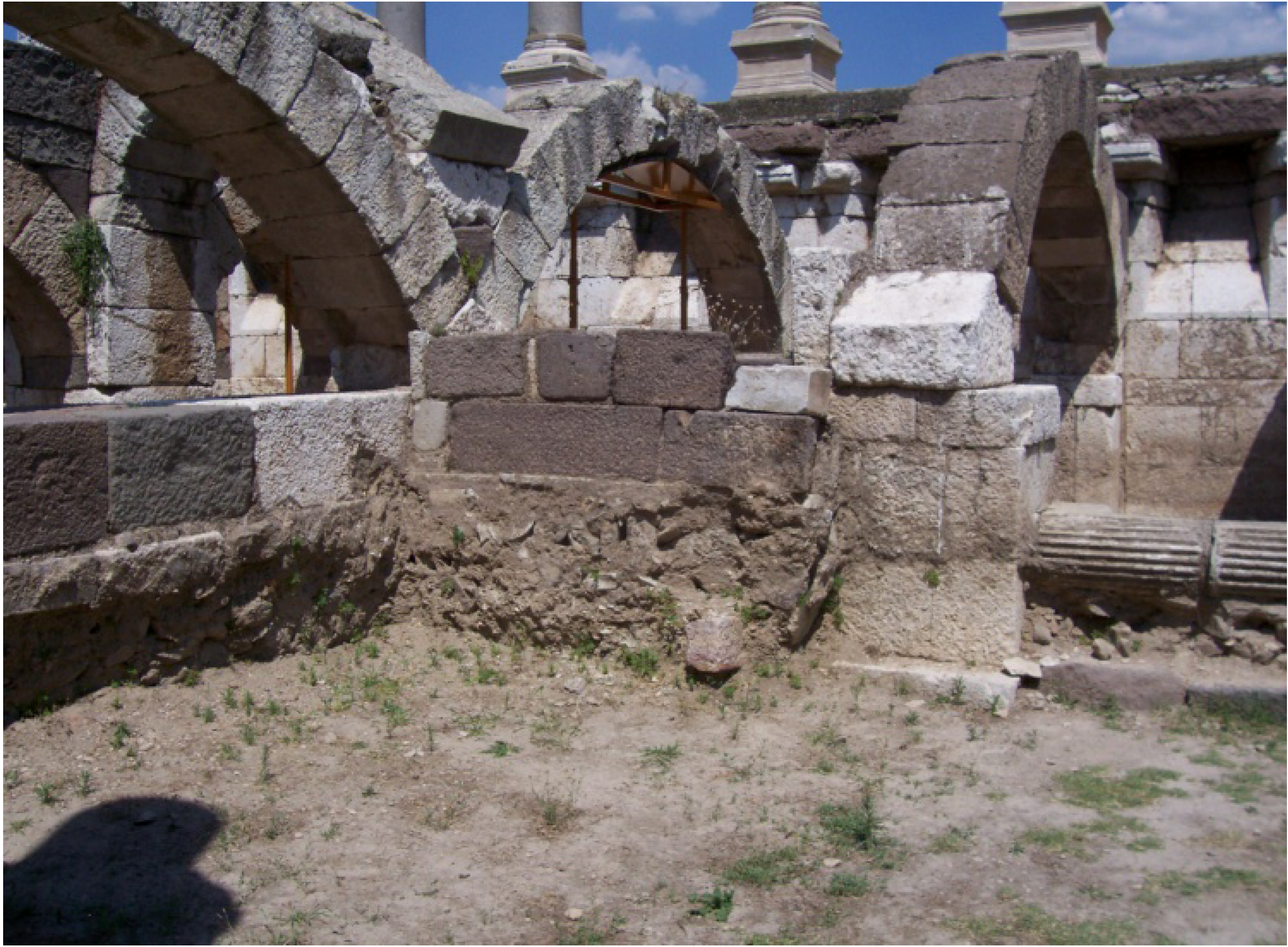
| Aspendos | Turkey | Roman | 3rd century AD | 20 | 5,600 |
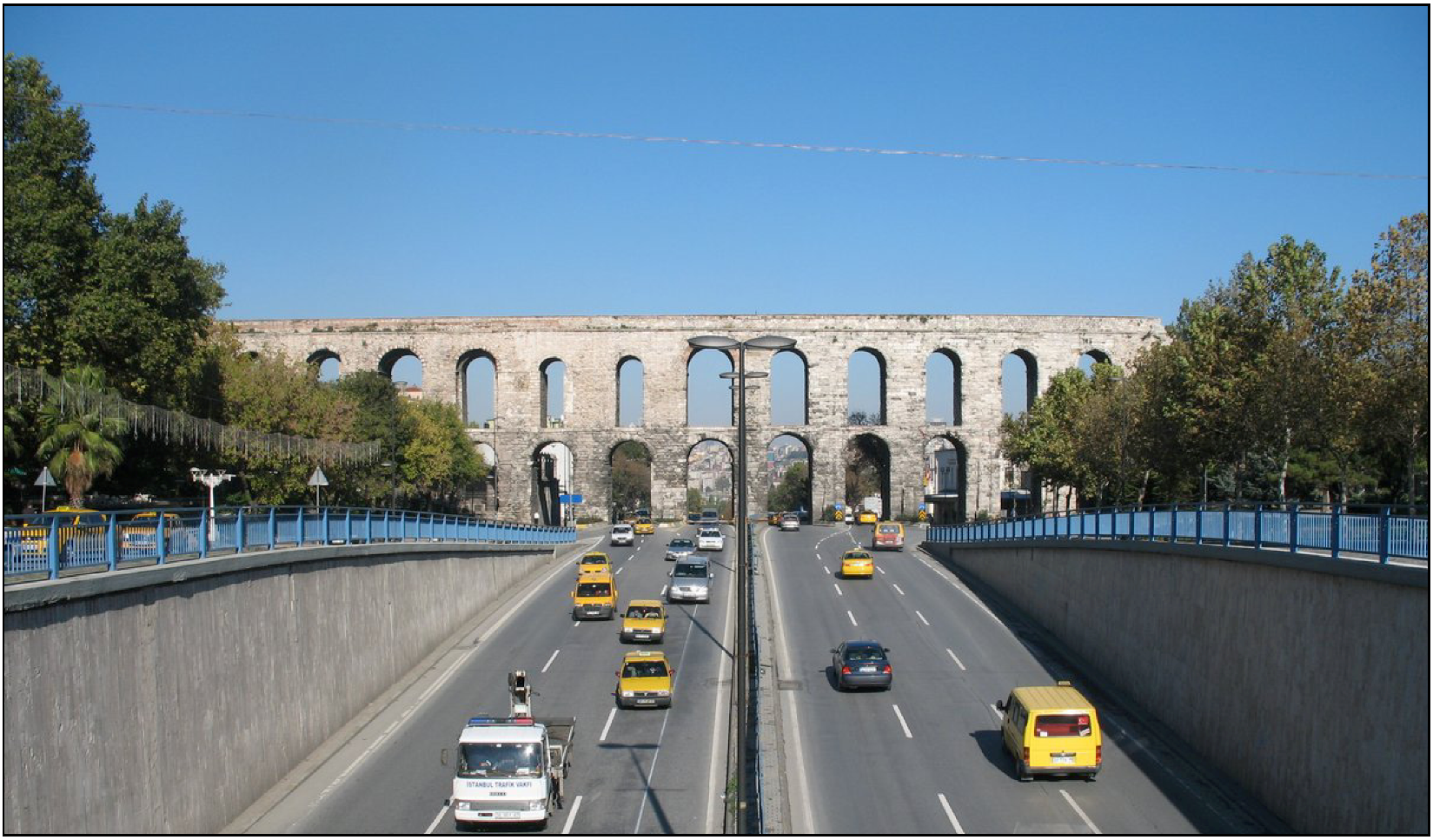
| Valens | Turkey | Roman | 4th century AD | 250 | - |
| Athens Roman (built channel of the aqueduct near the surface, locally on waterbridges) | Hellas | Roman | Middle 5th century AD | 21 |
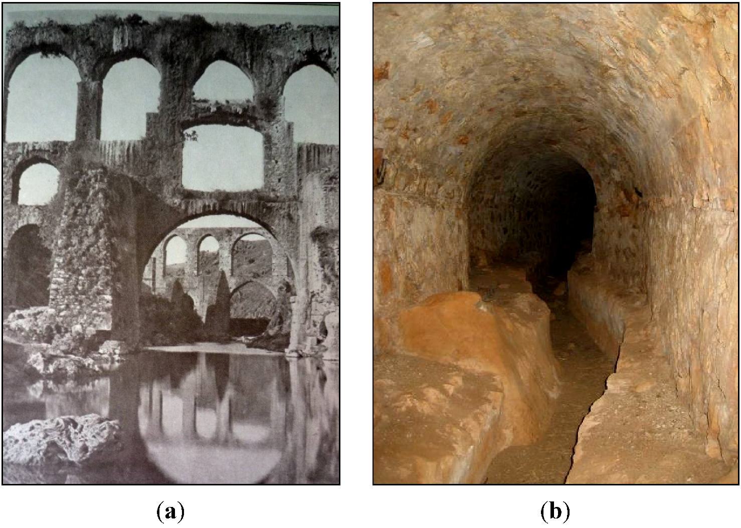
7. Byzantine Period and Middle Ages


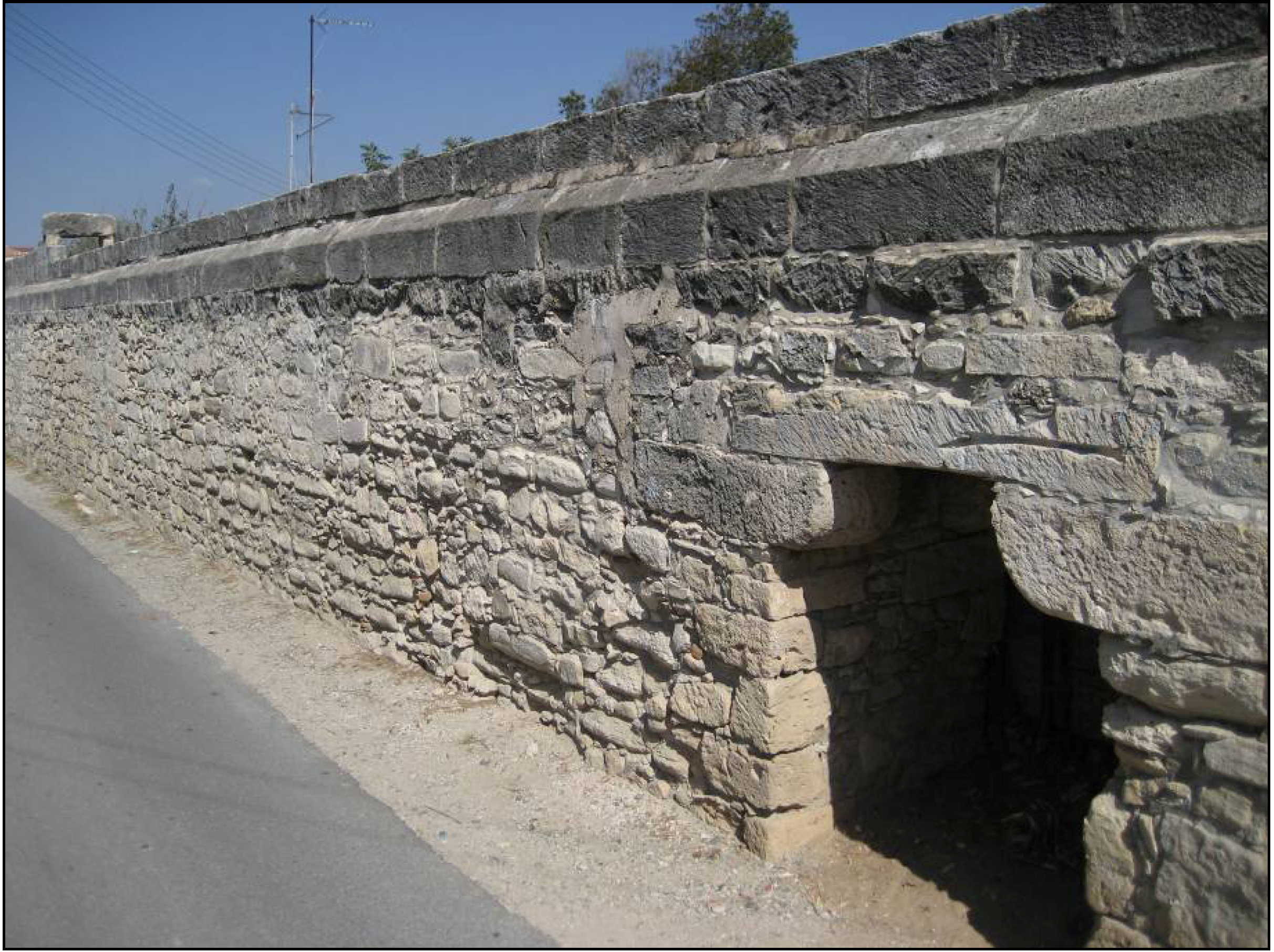
8. Ottoman and Byzantines Periods

9. Discussion and Conclusions
Acknowledgments
Conflicts of Interest
References
- Yang, K. Re-discussion on the design of Chang An in West Han Dynasty. Archaeology 1989, 4, 348–356. [Google Scholar]
- Koutsoyiannis, D.; Angelakis, A.N. Hydrologic and Hydraulic Sciences and Technologies in Ancient Greek Times. In The Encyclopedia of Water Sciences; Stewart, B.A., Howell, M., Eds.; Marcel Dekker Inc: New York, NY, USA, 2003; pp. 415–418. [Google Scholar]
- Tamburrino, A. Water Technology in Ancient Mesopotamia. In Ancient Water Technologies; Mays, L.W., Ed.; Springer: Dordrecht, The Netherland, 2010; pp. 29–51. [Google Scholar]
- Viollet, P.L. Water Management in the Early Bronze Age Civilization. In Proceedings of La Ingenieria Y La Gestion Del Agua a Traves de Los Tiempos, Alicante, Spain, 30 May–1 June 2006.
- Angelakis, A.N.; Savvakis, Y.M.; Charalampakis, G. Aqueducts during the Minoan Era. Water Sci. Technol. Water Supply 2007, 7, 95–102. [Google Scholar]
- Angelakis, A.N.; Spyridakis, S.V. Major urban water and wastewater systems in Minoan Crete, Greece. Water Sci. Technol. Water Supply 2013, 13, 564–573. [Google Scholar] [CrossRef]
- Nriagu, J. Environmental pollution and human health in ancient times. Encycl. Environ. Health 2011, 489–506. [Google Scholar] [CrossRef]
- Mays, L.W. Water Technology in Ancient Egypt. In Ancient Water Technologies; Mays, L.W., Ed.; Springer: Dordrecht, The Netherland, 2010; pp. 53–65. [Google Scholar]
- Franco, L. Ancient Mediterranean harbours:A heritage to preserve. Ocean Coast. Manag. 1996, 30, 115–151. [Google Scholar] [CrossRef]
- Viollet, P.L. L’hydraulique dans les civilisations anciennes (Hydraulics in ancient civilizations); Presse de l’Ecole des Ponts et Chaussées: Paris, France, 2000. [Google Scholar]
- Lightfoot, D. Survey of Infiltration Karez in Northern Iraq: History and Current Status of Underground Aqueducts; UNESCO, Report IQ/2009/SC/RP/1; United Nations Educational, Scientific and Cultural Organization (UNESCO): Paris, France, 2009. [Google Scholar]
- Stiros, S.C. Accurate measurements with primitive instruments: The “paradox” in the qanat design. J. Archaeol. Sci. 2006, 33, 1058–1064. [Google Scholar] [CrossRef]
- Wulff, H.E. The qanats of Iran. Sci. Am. 1968, 4, 94–105. [Google Scholar] [CrossRef]
- Sun, Q.; Tao, W.; Kobori, I.; Liang, L. Case Study V: Karez in the Turpan Region of China. In Seeing Traditional Technologies in a New Light Using Traditional Approaches for Water Management in Drylands; Bigas, H., Adeel, Z., Schuster, B., Eds.; United Nations Educational, Scientific and Cultural Organization: Paris, France, 2009. [Google Scholar]
- George, R.L. The history of plumbing. Plumb. Eng. 2001, 3, 45–53. [Google Scholar]
- Jansen, M. Water supply and sewage disposal at Mohenjo-Daro. World Archaeol. 1989, 21, 177–192. [Google Scholar] [CrossRef]
- Wright, R.P.; Bryson, R.A.; Schuldenrein, J. Water supply and history: Harappa and the Beas regional survey. Antiquity 2008, 82, 37–48. [Google Scholar]
- Neary, D.G.; Ice, G.G.; Rhett, J.C. Linkages between forest soils and water quality and quantity. For. Ecol. Manag. 2009, 258, 2269–2281. [Google Scholar] [CrossRef]
- Beach, T.; Luzzadder-Beach, S.; Dunning, N.; Cook, D. Human and natural impacts on fluvial and karst depressions of the Maya Lowlands. Geomorphology 2008, 101, 308–331. [Google Scholar] [CrossRef]
- Kirk, F.D.; Duffy, C.J. Prehispanic water pressure: A new world first. J. Archaeol. Sci. 2010, 37, 1027–1032. [Google Scholar] [CrossRef]
- Grossman, J.W. Human—landscape interactions. Encycl. Archaeol. 2008, 1458–1476. [Google Scholar] [CrossRef]
- Alvarado, G.E.; Soto, G.J. Volcanoes in the pre-Columbian life, legend, and archaeology of Costa Rica (Central America). J. Volcanol. Geotherm. Res. 2008, 176, 356–362. [Google Scholar] [CrossRef]
- Reyes-Knoche, A. Sustainable Water Supply—The Case of Pre-Columbian Peru. In Proceedings of the International Water Association (IWA) Specialized Conference on Water & Wastewater Technologies in Ancient Civilizations, Istanbul, Turkey, 22–24 March 2012.
- Reyes-Knoche, A. Water Supply and Sanitation in Ancient Peru: Pre-Columbian Cultures and the Incas. In Proceedings of the International Water Association (IWA) Specialized Conference on Water & Wastewater Technologies in Ancient Civilizations, Bari, Italy, 28–30 May 2009.
- Fairley, J.P., Jr. Geologic water storage in Precolumbian Peru. Lat. Am. Antiq. 2003, 14, 193–206. [Google Scholar] [CrossRef]
- Yuan, Y.H. An Outline History of Hydraulic Engineering History of China; China Press of Hydraulic Engineering & Hydraulic Power: Beijing, China, 1986. [Google Scholar]
- Zheng, X.Y. Water management in a city of southwest China before the 17th Century. Water Sci. Technol. 2013, 13, 574–581. [Google Scholar]
- Wittenberg, H.; Schachner, A. The ponds of Hattuša—Early groundwater management in the Hittite Kingdom. Water Sci. Technol. 2013, 13, 692–698. [Google Scholar]
- Öziş, U. Historical dams in Turkey; National Committee of International Commission on Large Dams: Ankara, Turkey, 1999. [Google Scholar]
- Ozkaldi, A.; Huseyin, A.; Koksal, B.C. Evaluation of historical water works in Turkey from hydraulic engineering point of view. In Proceedings of the International History Seminar on Irrigation and Drainage, Tehran, Iran, 2–5 May 2007.
- Garbrecht, G. Hydrologic and Hydraulic Concepts in Antiquity. In Hydraulics and Hydraulic Research: A Historical Review; Garbrecht, G., Ed.; Balkema Publisher: Rotterdam, The Netherlands, 1987; pp. 1–22. [Google Scholar]
- Fahlbusch, H. Water in human life: Technical innovations in hydraulic engineering in the last 5000 years. ICID J. 2000, 49, 1–16. [Google Scholar]
- Belli, O. Urartian Irrigation Canals in Eastern Anatolia; Archeology and Art Press: Istanbul, Turkey, 1997. [Google Scholar]
- Wessels, J.; Hoogeveen, R.J.A. Renovation of Qanats in Syria. In Sustainable Management of Marginal Drylands, Application of indigenous knowledge for coastal drylands, Proceedings of A Joint United Nations University (UNU)—United Nations Educational, Scientific and Cultural Organization (UNESCO)—International Center for Agricultural Research in the Dry Areas (ICARDA) International Workshop, Alexandria, Egypt, 21–25 September 2002.
- Caponetti, L. Gallerie drenanti e sistemi idraulici Etruschi. Il caso di Tuscania. In I Patrimoni di Comunità in Italia fra Storia e Cultura, Natura e Territorio, Proceedings of I Patrimoni di Comunità in Italia fra Storia e Cultura, Natura e Territorio, Parco Naturale del Bosco delle Sorti della Partecipazione di Trino (VC), Italy, 16–18 December 2005.
- Angelakis, A.N.; de Feo, G.; Laureano, P.; Zourou, A. Minoan and Etruscan hydro-technologies. Water 2013, 5, 972–987. [Google Scholar] [CrossRef]
- Martini, P.; Drusiani, R. History of the Water Supply of Rome as a Paradigm of Water Services Development in Italy. In Evolution of Water Supply Through the Millennia; Angelakis, A.N., Mays, L.W., Koutsoyiannis, D., Mamassis, N., Eds.; IWA Publishing: London, UK, 2012; pp. 444–466. [Google Scholar]
- Bambini, R.; Campagnoli, A.; Campagnoli, M.; Cappa, G. Un acquedotto etrusco-romano nel territorio di Cerveteri. Opera Ipogea 2007, 9, 95–104. [Google Scholar]
- Koutsoyiannis, D.; Zarkadoulas, N.; Angelakis, A.N.; Tchobanoglous, G. Urban water management in Ancient Greece: Legacies and lessons. ASCE J. Water Resour. Plan. Manag. 2008, 134, 45–54. [Google Scholar] [CrossRef]
- Zarkadoulas, N.; Koutsoyiannis, D.; Manassis, N.; Angelakis, A.N. A Brief History of Urban Water Management in Ancient Greece. In Evolution of Water Supply through the Millennia; Angelakis, A.N., Mays, L.W., Koutsoyiannis, D., Mamassis, N., Eds.; IWA Publishing: London, UK, 2012; Chapter 10; pp. 259–270. [Google Scholar]
- Bakhuizen, S.C. Studies in the Topography of Chalcis on Euboea—A Discussion of the Sources; Brill Academic Publishers: Leiden, The Netherlands, 1985. [Google Scholar]
- Kiel, M. The Turkish Aqueduct of Chalkis. A Note on the Date of Construction and the Identity of Its Founder. In Studies in the Topography of Chalcis on Euboea; Bakhuizen, S.C., Kiel, M., Eds.; E.J. Brill: Leiden, The Netherlands, 1985. [Google Scholar]
- Garbrecht, J.D.; Garbrecht, G.K.H. Water Supply Challenges and Solutions of the Ancient City of Pergamon. In Proceedings of Oklahoma Water Conference 2005, Stillwater, OK, USA, 27–28 September, 2005.
- De Feo, G.; Laurano, P.; Mays, L.W.; Angelakis, A.N. Contribution of the Greek and Roman Civilizations to the Evolution of Water Supply. In Evolution of Water Supply through the Millennia; Angelakis, A.N., Mays, L.W., Koutsoyiannis, D., Mamassis, N., Eds.; IWA Publishing: London, UK, 2012; Chapter 14; pp. 351–382. [Google Scholar]
- Bellwald, U.; Al-Huneidi, M.; Salihi, A.; Keller, D.; Naser, R.; Al-Eisawi, D. The Petra Siq, Nabataean Hydrology Uncovered; Petra National Trust: Amman, Jordan, 2003. [Google Scholar]
- Mouton, M.; Al-Dbiyat, M. Stratégies d’acquisition de l’eau et société au moyen orient depuis l’antiquité; Institut français du Proche Orient: Beyrouth, Lebanon, 2009. [Google Scholar]
- Tsuk, T. Water at the End of the Tunnel: Touring Israel’s Ancient Water System (in Hebrew); Yad Izhak Ben-Zvi Publications: Jerusalem, Israel, 2013. [Google Scholar]
- ROMAQ Database Homepage. Available online: http://www.romaq.org (accessed on 25 November 2013).
- Bailhache, M. L’évolution du débit des aqueducs gallo-romains (Evolution of the flow rate of Roman aqueducts). Doss. Archéol. 1979, 38, 19–49. [Google Scholar]
- Hodge, A.T. Roman Aqueducts and Water Supply, 2nd ed.; Duckwort: London, UK, 2008. [Google Scholar]
- Kessener, P.; Piras, S. The pressure line of the Aspendos aqueduct. Adalya II. 1998, pp. 159–187. Available online: http://www.romanaqueducts.info/aquapub/kessener1998a.pdf (accessed on 25 November 2013).
- Matias, R.R. La Mineria Aurifera Romana del Nordoeste de Hispania: Ingenieria Minera Y Gestion de las Explotaciones Auriferas Romanas en la Sierra del Teleno (Leon, Espana). In Proceedings of the III Congreso de las Obras Públicas Romanas, Astorga, Spain, 5–7 October 2006.
- Wikander, O. Handbook of Ancient Water Technology; Brill Academic Publishers: Leiden, The Netherlands, 2000; p. 471. [Google Scholar]
- Ortloff, C.R. Computational fluid dynamics investigation of the hydraulic behaviour of the Roman inverted siphon system at Aspendos, Turkey. J. Archaeol. Sci. 2003, 30, 417–428. [Google Scholar] [CrossRef]
- Haut, B.; Viviers, D. Water Supply in the Middle East During Roman and Byzantine Periods. In Evolution of Water Supply through the Millennia; Angelakis, A.N., Mays, L.W., Koutsoyiannis, D., Mamassis, N., Eds.; IWA Publishing: London, UK, 2012; Chapter 13; pp. 319–350. [Google Scholar]
- Abbasoglu, H. Perge. Curr. World Archaeol. 2010, 41, 28. [Google Scholar]
- Tunçer, M. Perge Conservation Plan Report; Perge Conservation Plan Research Report; Akman Project Co: Perge, Turkey, 1992. [Google Scholar]
- De Feo, G.; Mays, L.W.; Angelakis, A.N. Water and Wastewater Management Technologies in the Ancient Greek and Roman Civilizations. In Treatise on Water Science; Wilderer, P., Ed.; Academic Press: Oxford, UK, 2011; Volume 4, pp. 3–22. [Google Scholar]
- De Feo, G.; Napoli, R.M.A. Historical development of the Augustan aqueduct in Southern Italy: Twenty centuries of works from Serino to Naples. Water Sci. Technol. 2007, 7, 131–138. [Google Scholar]
- De Feo, G.; De Gisi, S.; Malvano, C.; De Biase, O. The greatest water reservoirs in the ancient Roman world and the “Piscina Mirabilis” in Misenum. Water Sci. Technol. 2010, 10, 350–358. [Google Scholar]
- De Feo, G.; Laureano, P.; Drusiani, R.; Angelakis, A.N. Water and wastewater management technologies through the centuries. Water Sci. Technol. 2010, 10, 337–349. [Google Scholar]
- Surmelihindi, G.; Passchier, C.W.; Spötl, C.; Kessener, P.; Bestmann, M.; Jacob, D.E.; Baykan, O.N. Laminated carbonate deposits in Roman aqueducts: Origin, processes and implications. Sedimentology 2013, 60, 961–982. [Google Scholar] [CrossRef]
- Passchier, C.W.; Wiplinger, G.; Güngör, T.; Kessener, P.; Sürmelihindi, G. Evidence for major displacement on a normal fault in Western Turkey dislocating a Roman aqueduct. Terra Nova 2013, (in press). [Google Scholar]
- Chiotis, E.D.; Marinos, G.P. Geological aspects on the sustainability of ancient aqueducts of Athens. Bull. Geol. Soc. Greece 2012, 46, 16–38. [Google Scholar]
- Haut, B.; Viviers, D. Analysis of the water supply system of the city of Apamea, using Computational Fluid Dynamics. Hydraulic system in the north-eastern area of the city, in the Byzantine period. J. Archaeol. Sci. 2007, 34, 415–427. [Google Scholar] [CrossRef]
- Ortloff, C.R.; Crouch, P.D. The urban water supply and distribution system of the Ionian city of Ephesos. J. Archaeol. Sci. 2001, 28, 843–860. [Google Scholar] [CrossRef]
- Çeçen, K. Roma Su Yollarının En Uzunu; Türkiye Sınai Kalkınma Bankası: İstanbul, Turkey, 1996. [Google Scholar]
- Hodge, A.T. Roman Aqueducts and Water Supply, 2nd ed.; Duckwort: London, UK, 2008. [Google Scholar]
- Wiplinger, G. The Aqueducts of Ephesos. Available online: http://www.oeai.at/index.php/water-supply.html (accessed on 11 August 2011).
- Viollet, P.L. Aqueducts: A short history. J. Hydraul. Res. 2003, 20, 26–27. [Google Scholar]
- Lancaster, L.C. Early Examples of So-Called Pitched Brick Barrel Vaulting in Roman Greece and Asia Minor: A Question of Origin and Intention. In Proceedings of Bautechnik imantiken und vorantiken kleinasien, An Internationale Konferenz, Istanbul, Turkey, 13–16 June 2007.
- Levi, E.A. The Agora of İzmir and Cultural Tourism; The International Committee for Documentation of Cultural Heritage (CIPA): Antalya, Turkey, 2003. [Google Scholar]
- Garceau, M.E. “I call the people.” Church bells in fourteenth-century Catalunya. J. Mediev. Hist. 2011, 37, 197–214. [Google Scholar] [CrossRef]
- Rugania, B.; Pulselli, R.M.; Niccolucci, V.; Bastianoni, S. Environmental performance of a XIV century water management system: An emergy evaluation of cultural heritage. Resour. Conserv. Recycl. 2011, 56, 117–125. [Google Scholar] [CrossRef]
- Kanetaki, E. Ottoman Baths in Greece: A Contribution to the Study of Their History and Architecture. In Bathing Culture of Anatolian Civilizations: Architecture, History, and Imagination; Ergin, N., Ed.; Peeters Publishing: Leuven, Belgium, 2011; pp. 221–255. [Google Scholar]
- Kanetaki, E. Architectural and Technical Aspects Regarding the Construction of Hammams in Ottoman Greece. In Proceedings of 2nd International Conference Balneorient; Thermae, Hammam, Damascus, Syria: 2012.
- Kiel, M. Yenice-i Vardar: A Forgotten Turkish Cultural Centre in Macedonia of the 15th & 16th Century. In Studia Byzantina et Neohellenica Neerlandica 3; E.J. Brill: Leiden, The Netherlands, 1971; pp. 300–329. [Google Scholar]
- Lowry, H. The Shaping of Ottoman Balkans, 1350–1500; B.U.P.: Istanbul, Turkey, 2008. [Google Scholar]
- Antoniou, G.P. The Architecture and Evolution of the Aqueduct of Pylos—Navarino. In Proceedings of IWA Specialized Conference on Water & Wastewater Technologies in Ancient Civilizations, Istanbul, Turkey, 22–24 March 2012.
- Antoniou, G.P. Ottoman Aqueducts in the Helladic Region—Architecture and Construction. In Proceedings of Comité International des Études Pré-Ottomanes et Ottomanes (CIEPO 20), Rethymnon, Greece, 27 June–1 July 2012.
- Benet, J. The Fortress of Avarin I-Cedid. In A Historical and Economic Geography of Ottoman Greece; Hesperia Supplements 34; Zarinebaf, F., Ed.; American School of Classical Studies at Athens: Princenton, NJ, USA, 2005; pp. 241–265. [Google Scholar]
- Kiel, M. Remarks on Some Ottoman-Turkish Aqueducts and Water Supply Systems in the Balkans—Kavalla, Chalkis, Levkas and Ferai/Ferecik. In De turcicis aliisque rebus: Commentarii Henry Hofman dedicati; Boeschoten, H., Ed.; Instituut voor Oosterse Talen en Culturen: Utrecht, The Netherlands, 1992; pp. 105–139. [Google Scholar]
- Miljcovits-Pepec, P. Υδραγωγείο, Σκόπια ΠΓΔΜ. In Κοσμική Αρχιτεκτονική στα Βαλκάνια και η Διατήρησή της; Historical Manuscripts Commission (HMC): Thessaloniki, Greece, 1997; pp. 342–343. [Google Scholar]
- Kiel, M. Ottoman Building Activity along the Via Egnatia. In The Via Egnatia Under Ottoman Rule 1380–1699: Halcyon Days in Crete II; Zachariadou, E., Ed.; Crete University Press: Rethymnon, Greece, 1996; p. 155. [Google Scholar]
- Vavliakis, E. The Qanat systems in Greece: A study of Qanat Systems in Phyllida of Seeres from Morphological, Hydrographic and Socio-Economical View; Aristotle University of Thessaloniki: Thessaloniki, Greece, 1989. [Google Scholar]
- Voudouris, K.; Christodoulakos, Y.; Stiakakis, M.; Angelakis, A.N. Hydrogeological characteristics of Hellenic aqueducts like qanats. Water 2013, 5, 1326–1345. [Google Scholar] [CrossRef]
- Pliny the Elder. In Natural History, Volume X, Books 36–37, 2nd ed.; Harvard University Press: Harvard, UK, 1962.
- Blumenstein, O.; Weingartner, H.; Vavelidis, M. Qanats between Menikion and Pangeon Mountains: A Forgotten and Endangered Resource for Local Water Supply. In Proceedings of XIX Congress of the Carpathian Balkan Geological Association, Thessaloniki, Greece, 23–26 September 2010; pp. 23–29.
© 2013 by the authors; licensee MDPI, Basel, Switzerland. This article is an open access article distributed under the terms and conditions of the Creative Commons Attribution license (http://creativecommons.org/licenses/by/3.0/).
Share and Cite
De Feo, G.; Angelakis, A.N.; Antoniou, G.P.; El-Gohary, F.; Haut, B.; Passchier, C.W.; Zheng, X.Y. Historical and Technical Notes on Aqueducts from Prehistoric to Medieval Times. Water 2013, 5, 1996-2025. https://doi.org/10.3390/w5041996
De Feo G, Angelakis AN, Antoniou GP, El-Gohary F, Haut B, Passchier CW, Zheng XY. Historical and Technical Notes on Aqueducts from Prehistoric to Medieval Times. Water. 2013; 5(4):1996-2025. https://doi.org/10.3390/w5041996
Chicago/Turabian StyleDe Feo, Giovanni, Andreas N. Angelakis, Georgios P. Antoniou, Fatma El-Gohary, Benoît Haut, Cees W. Passchier, and Xiao Yun Zheng. 2013. "Historical and Technical Notes on Aqueducts from Prehistoric to Medieval Times" Water 5, no. 4: 1996-2025. https://doi.org/10.3390/w5041996