
ALOS/PALSAR InSAR Time-Series Analysis for Detecting Very Slow-Moving Landslides in Southern Kyrgyzstan

Abstract
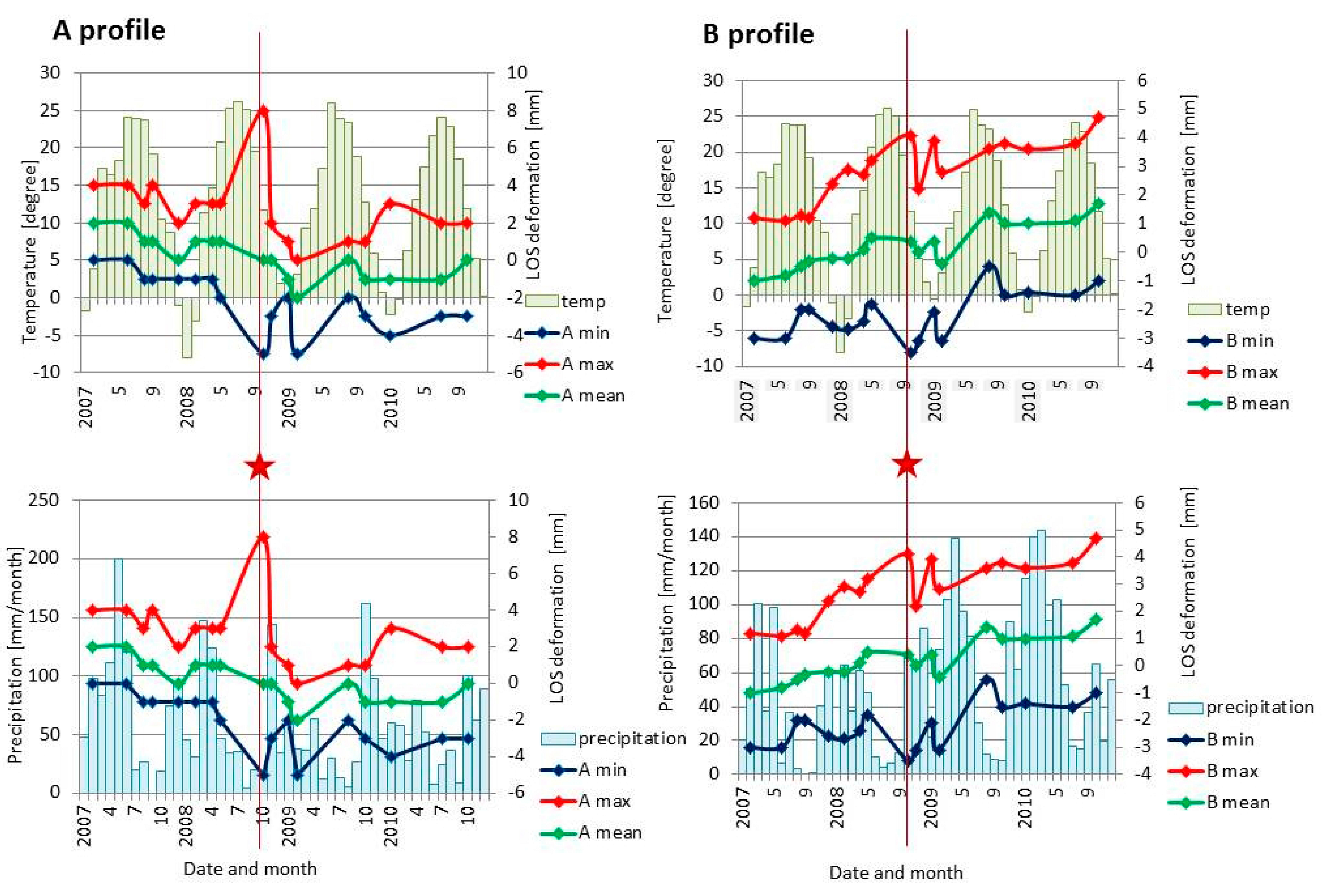
:
1. Introduction

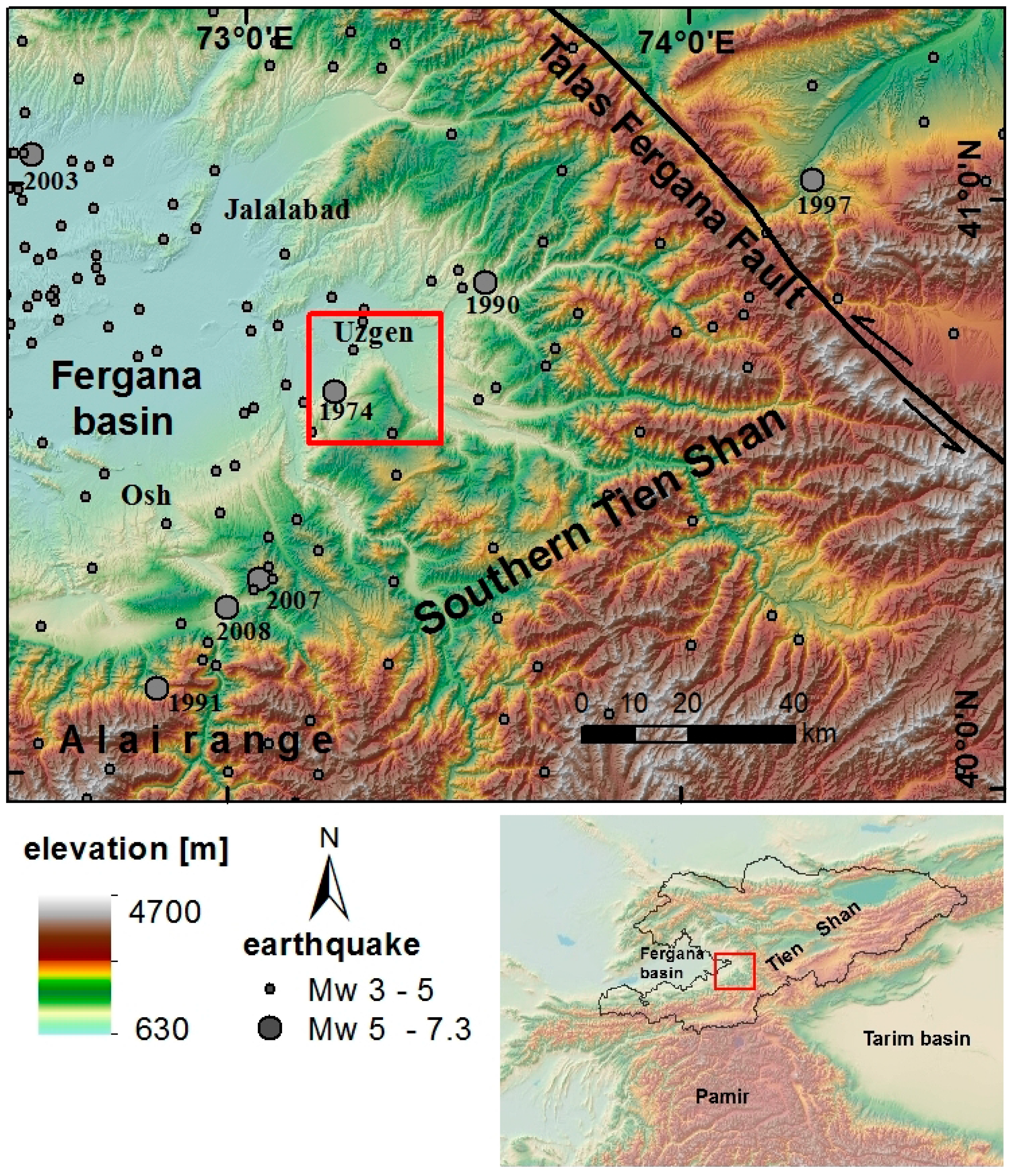
2. Study Area
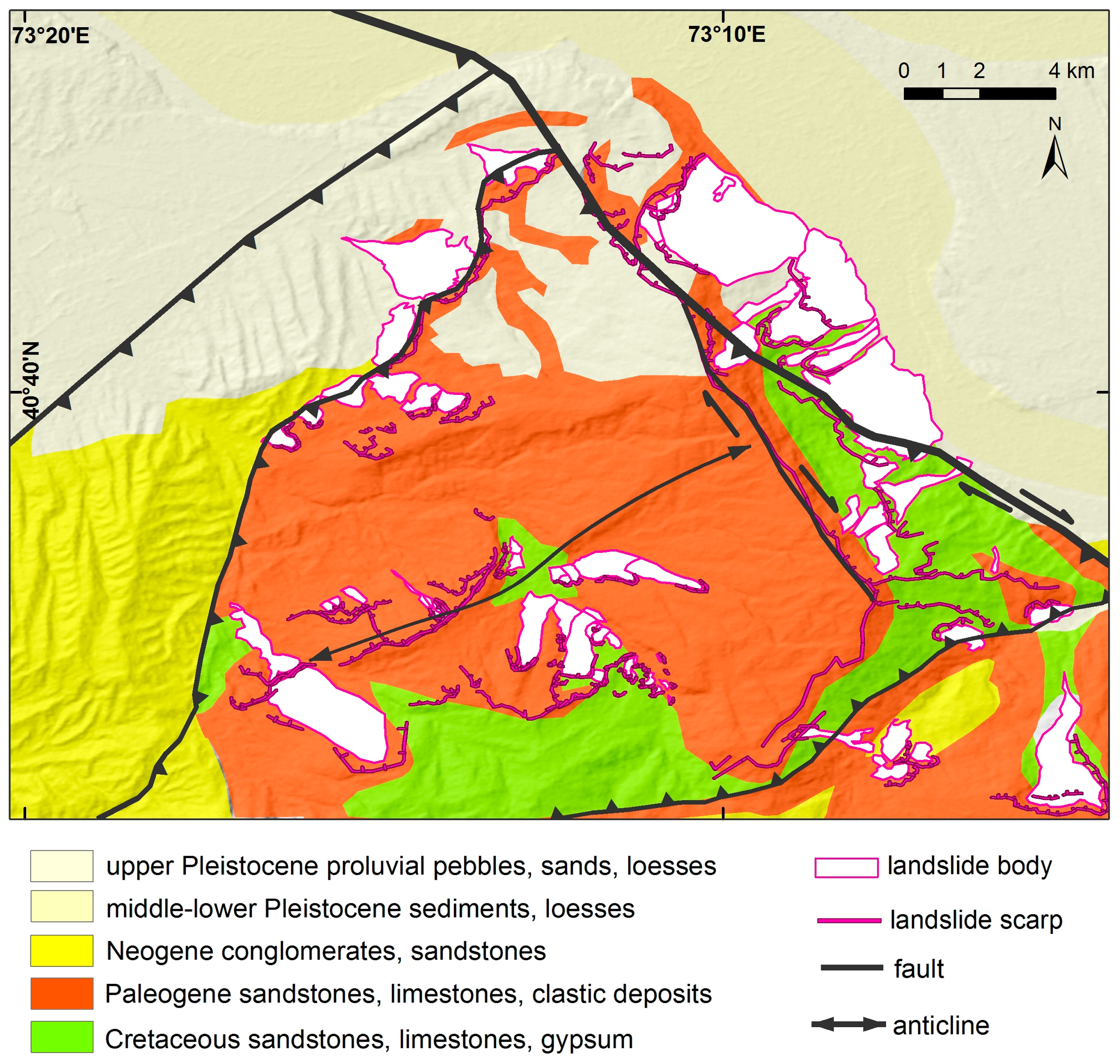
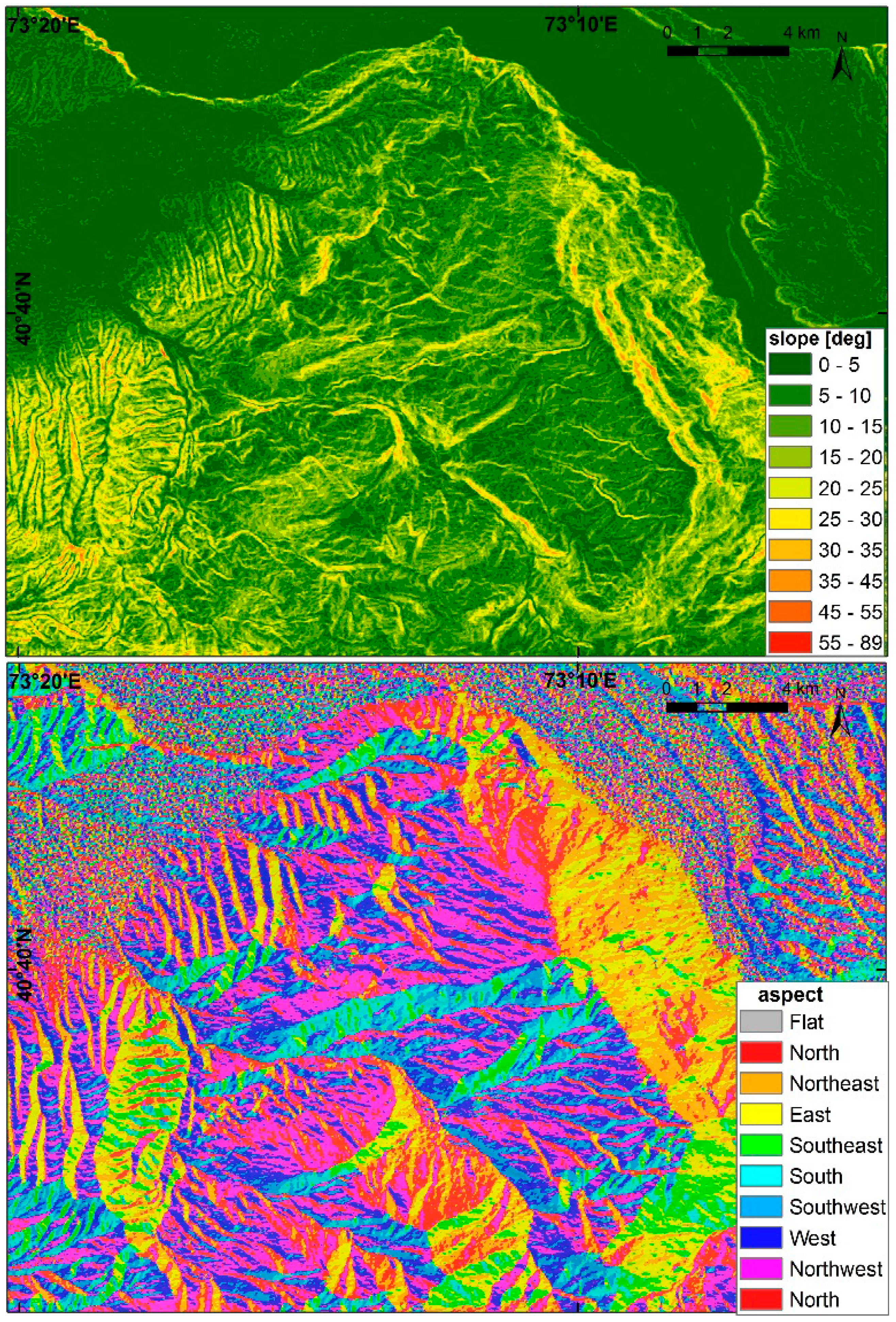
2.1. Geological and Geomorphological Settings
2.2. Local Climate and Seismicity
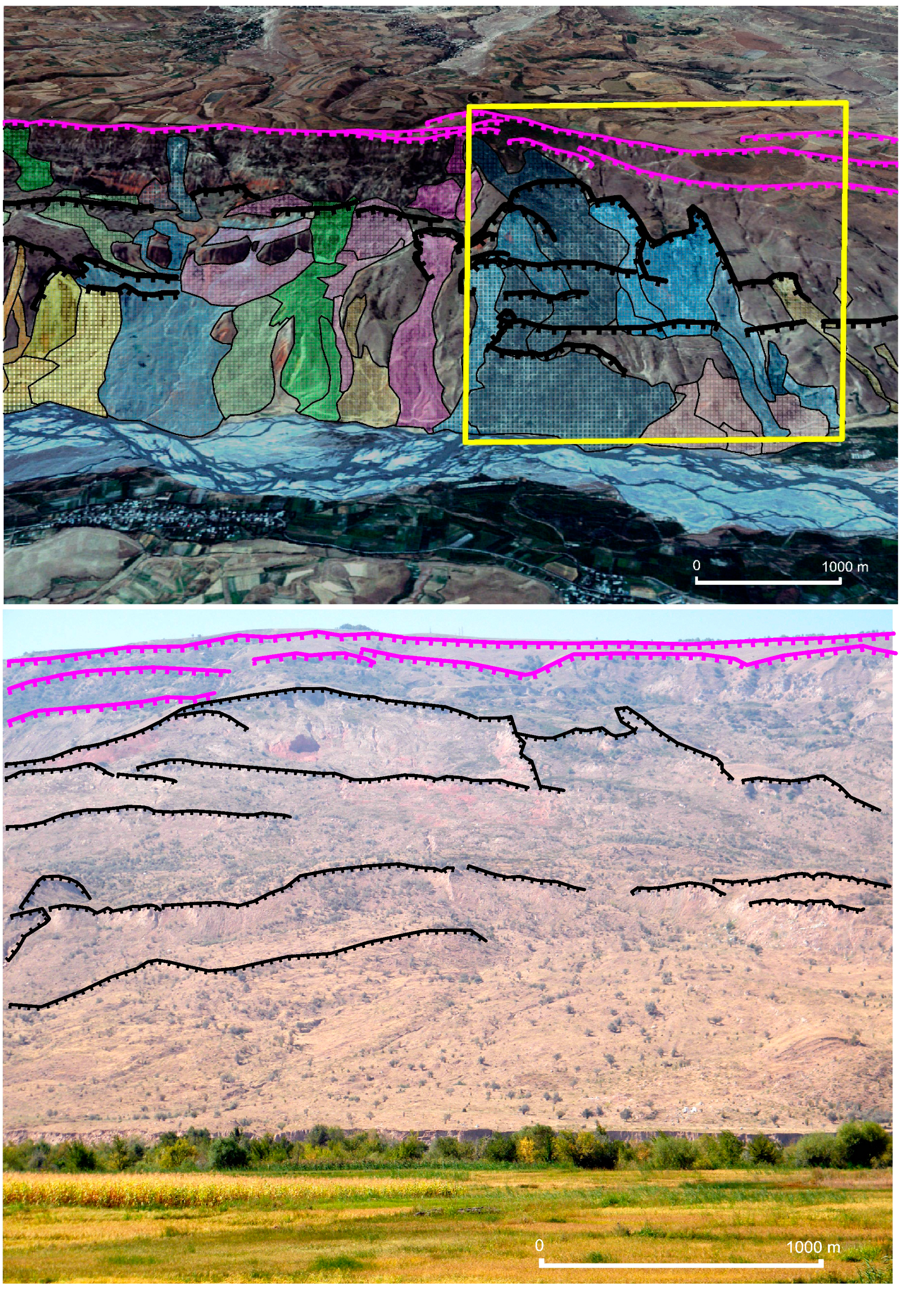
2.3. The Landslides
3. Data and Methodology
3.1. Data
3.2. StaMPS Method
3.3. StaMPS Processing
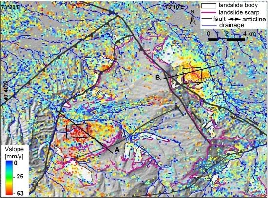
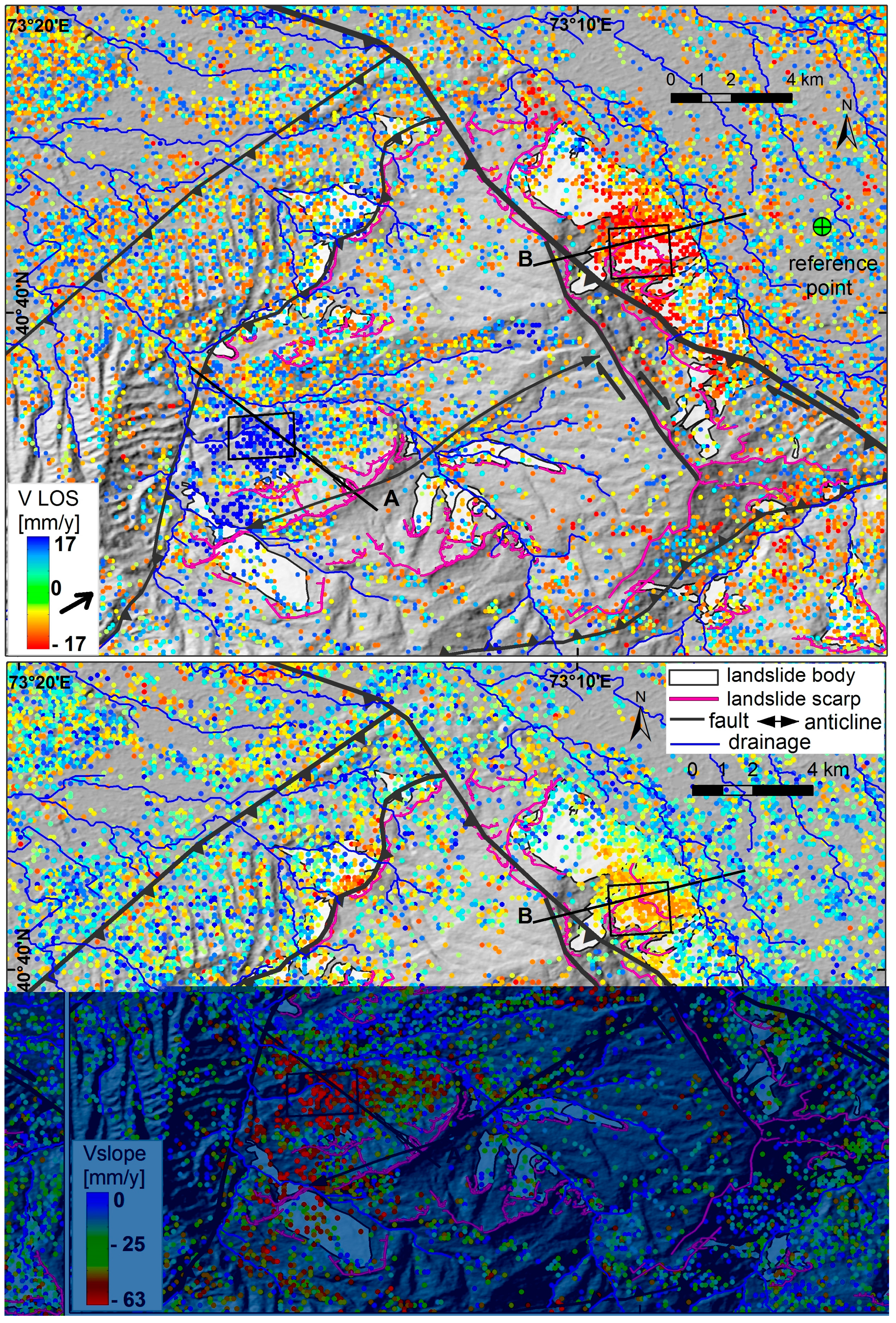
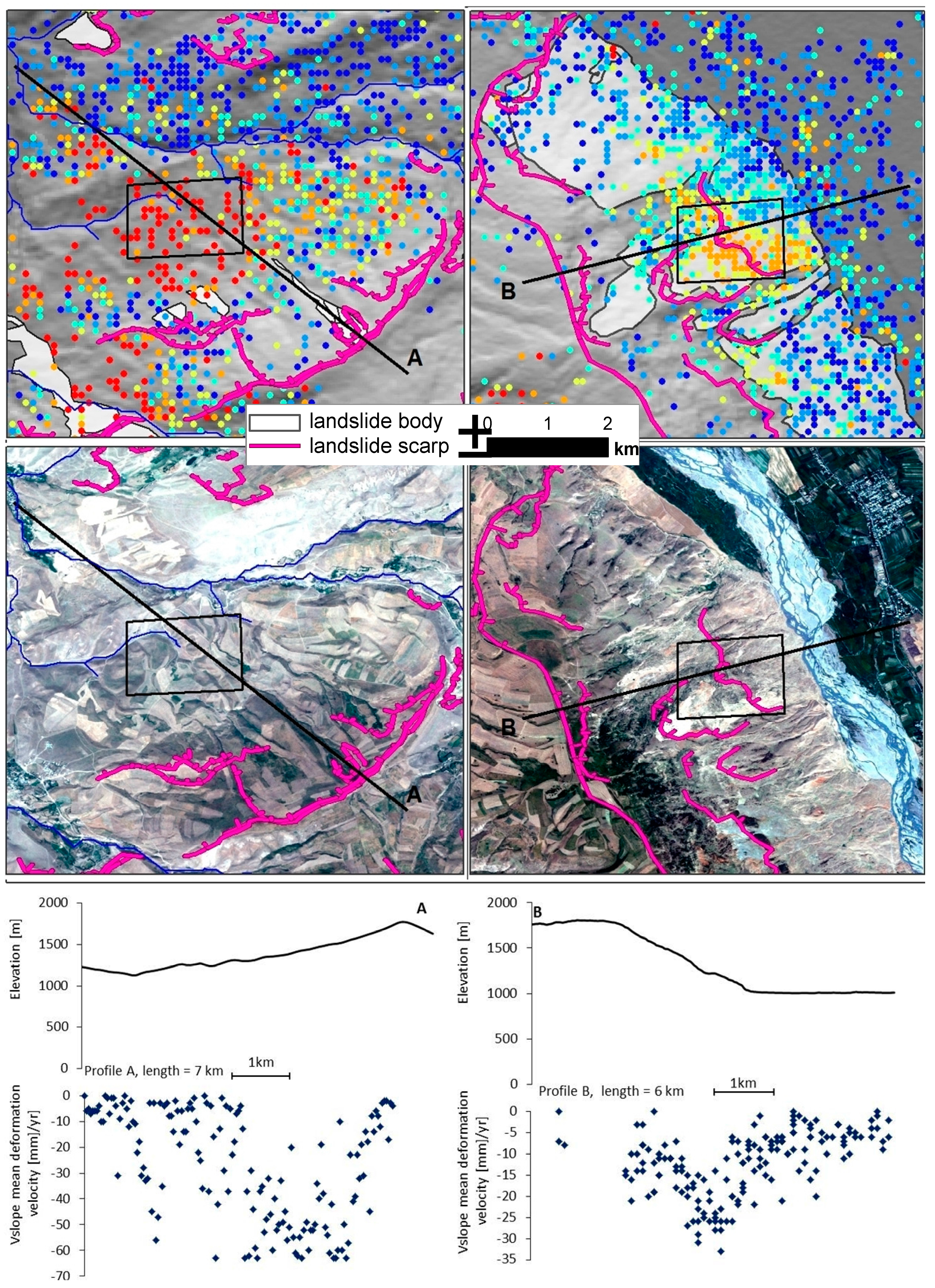
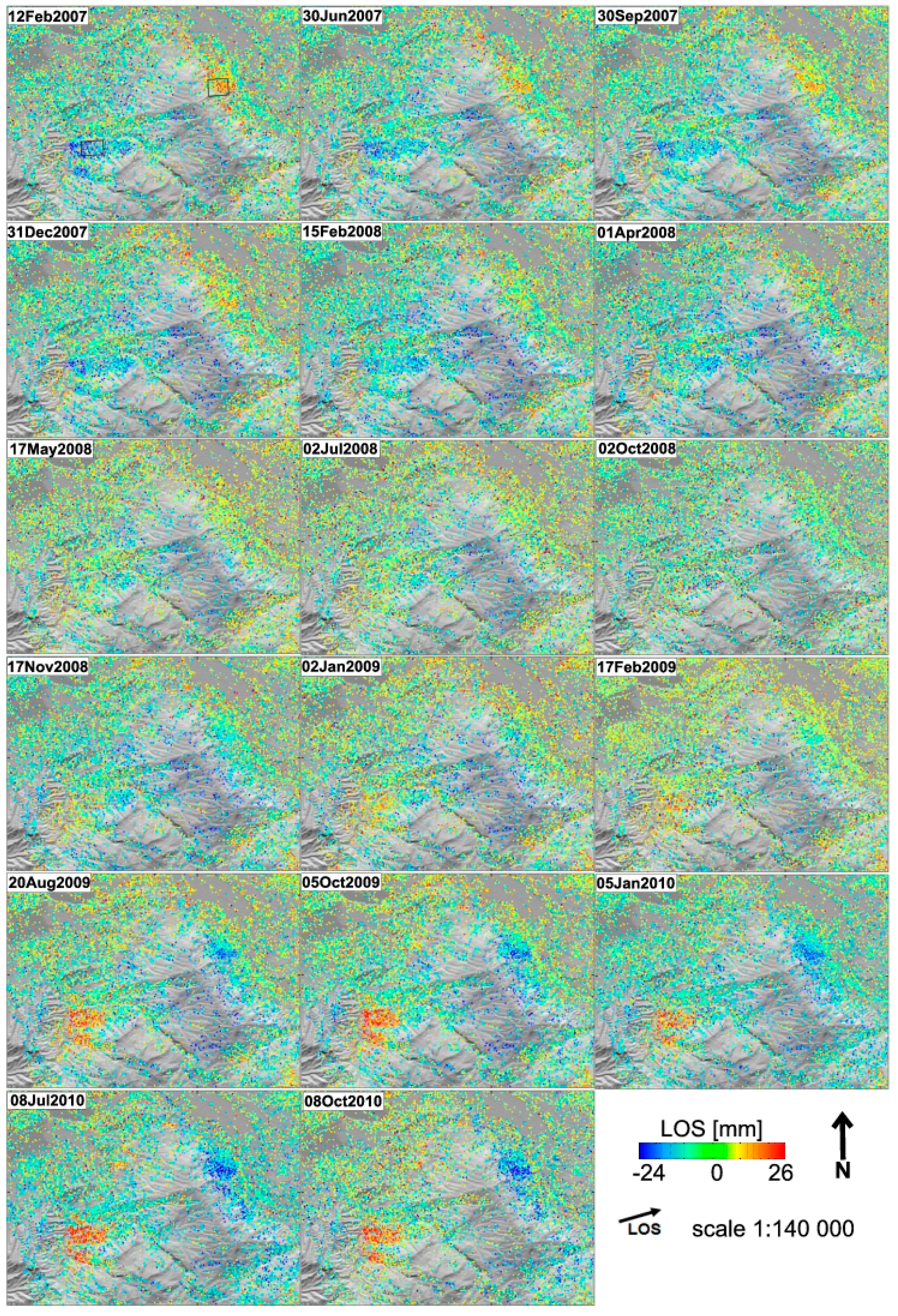
3.4. StaMPS Results Visualization and Deformation along the Local Steepest Slope

4. SBAS Results and Interpretation
4.1. Spatial Distribution of Landslide Deformation


4.2. Temporal Evolution of Landslide Deformation
5. Discussion
5.1. SBAS Results Assessment
5.2. Downslope Deformations of Landslides
5.3. Potential Controls on Landslide Activity
6. Conclusions
Acknowledgments
Author Contributions
Conflicts of Interest
References
- Hungr, O.; Leroueil, S.; Picarelli, L. The varnes classification of landslide types, an update. Landslides 2014, 11, 167–194. [Google Scholar] [CrossRef]
- Cruden, D.; Varnes, D. Landslide types and processes. In Landslides: Investigation and Mitigation; Turner, A.K., Schuster, R.L., Eds.; National Academy Press: Washington, DC, USA, 1996; pp. 36–75. [Google Scholar]
- Herrera, G.; Gutierrez, F.; Garcia-Davalillo, J.C.; Guerrero, J.; Notti, D.; Galve, J.P.; Fernandez-Merodo, J.A.; Cooksley, G. Multi-sensor advanced DInSAR monitoring of very slow landslides: The tena valley case study (central Spanish Pyrenees). Remote Sens. Environ. 2013, 128, 31–43. [Google Scholar] [CrossRef]
- Tolomei, C.; Taramelli, A.; Moro, M.; Saroli, M.; Aringoli, D.; Salvi, S. Analysis of the deep-seated gravitational slope deformations over Mt. Frascare (central Italy) with geomorphological assessment and DInSAR approaches. Geomorphology 2013, 201, 281–292. [Google Scholar] [CrossRef]
- Calo, F.; Ardizzone, F.; Castaldo, R.; Lollino, P.; Tizzani, P.; Guzzetti, F.; Lanari, R.; Angeli, M.G.; Pontoni, F.; Manunta, M. Enhanced landslide investigations through advanced DInSAR techniques: The ivancich case study, Assisi, Italy. Remote Sens. Environ. 2014, 142, 69–82. [Google Scholar] [CrossRef]
- Castaldo, R.; Tizzani, P.; Lollino, P.; Calò, F.; Ardizzone, F.; Manunta, M.; Guzzetti, F.; Lanari, R. The ivancich active landslide process (Assisi, Central Italy) analysed via numerical modeling jointly optimized by DInSAR and inclinometric data. In Engineering Geology for Society and Territory; Lollino, G., Giordan, D., Crosta, G.B., Corominas, J., Azzam, R., Wasowski, J., Sciarra, N., Eds.; Springer: Berlin, Germany, 2015; Volume 2, pp. 1513–1517. [Google Scholar]
- Tofani, V.; Raspini, F.; Catani, F.; Casagli, N. Persistent Scatterer Interferometry (PSI) technique for landslide characterization and monitoring. Remote Sens. 2013, 5, 1045–1065. [Google Scholar] [CrossRef]
- Tantianuparp, P.; Shi, X.; Zhang, L.; Balz, T.; Liao, M. Characterization of landslide deformations in three gorges area using multiple InSAR data stacks. Remote Sens. 2013, 5, 2704–2719. [Google Scholar] [CrossRef]
- Sun, Q.; Zhang, L.; Ding, X.; Hu, J.; Liang, H. Investigation of slow-moving landslides from ALOS/PALSAR images with TCPInSAR: A case study of Oso, USA. Remote Sens. 2014, 7, 72–88. [Google Scholar] [CrossRef]
- Lu, P.; Bai, S.B.; Casagli, N. Investigating spatial patterns of persistent scatterer interferometry point targets and landslide occurrences in the Arno River Basin. Remote Sens. 2014, 6, 6817–6843. [Google Scholar] [CrossRef]
- Bianchini, S.; Herrera, G.; Mateos, R.M.; Notti, D.; Garcia, I.; Mora, O.; Moretti, S. Landslide activity maps generation by means of persistent scatterer interferometry. Remote Sens. 2013, 5, 6198–6222. [Google Scholar] [CrossRef]
- Akbarimehr, M.; Motagh, M.; Haghshenas-Haghighi, M. Slope stability assessment of the sarcheshmeh landslide, northeast Iran, investigated using InSAR and GPS observations. Remote Sens. 2013, 5, 3681–3700. [Google Scholar] [CrossRef]
- Wasowski, J.; Bovenga, F. Investigating landslides and unstable slopes with satellite multi temporal interferometry: Current issues and future perspectives. Eng. Geol. 2014, 174, 103–138. [Google Scholar] [CrossRef]
- Yerokhin, S.A. Investigation of Landslide Occurence in Osh and Djalalabad Provinces of the Kyrgyz Republic; Institute of Geology: Bishkek, Kyrgyzstan, 1999. [Google Scholar]
- Ibatulin, K.V. Monitoring of Landslides in Kyrgyzstan; Ministry of Emergency Situations of the Kyrgyz Republic: Bishkek, Kyrgyzstan, 2011. (in Russian) [Google Scholar]
- Roessner, S.; Wetzel, H.; Kaufmann, H.; Sarnagoev, A. Potential of satellite remote sensing and GIS for landslide hazard assessment in southern Kyrgyzstan (Central Asia). Nat. Hazards 2005, 35, 395–416. [Google Scholar] [CrossRef]
- Wetzel, H.U.; Roessner, S.; Sarnagoev, A. Remote sensing and GIS based geological mapping for assessment of landslide hazard in southern Kyrgyzstan (Central Asia). In Management Information Systems 2000: GIS and Remote Sensing; WIT Press: Southampton, UK, 2000; pp. 355–366. [Google Scholar]
- Golovko, D.; Roessner, S.; Behling, R.; Wetzel, H.-U.; Kleinschmit, B. Development of multi-temporal landslide inventory information system for southern Kyrgyzstan using GIS and satellite remote sensing. Photogramm. Fernerkund. Geoinf. 2015, 2015, 157–172. [Google Scholar] [CrossRef]
- Behling, R.; Roessner, S.; Kaufmann, H.; Kleinschmit, B. Automated spatiotemporal landslide mapping over large areas using rapideye time series data. Remote Sens. 2014, 6, 8026–8055. [Google Scholar] [CrossRef]
- Teshebaeva, K.; Sudhaus, H.; Echtler, H.; Schurr, B.; Roessner, S. Strain partitioning at the eastern Pamir-Alai revealed through SAR data analysis of the 2008 Nura earthquake. Geophys. J. Int. 2014, 198, 760–774. [Google Scholar] [CrossRef]
- Motagh, M.; Wetzel, H.U.; Roessner, S.; Kaufmann, H. A Terrasar-X InSAR study of landslides in southern Kyrgyzstan, Central Asia. Remote Sens. Lett. 2013, 4, 657–666. [Google Scholar] [CrossRef]
- Notti, D.; Davalillo, J.C.; Herrera, G.; Mora, O. Assessment of the performance of X-band satellite radar data for landslide mapping and monitoring: Upper Tena Valley case study. Nat. Hazard Earth Syst. 2010, 10, 1865–1875. [Google Scholar] [CrossRef] [Green Version]
- Lanari, R.; Casu, F.; Manzo, M.; Zeni, G.; Berardino, P.; Manunta, M.; Pepe, A. An overview of the small baseline subset algorithm: A DInSAR technique for surface deformation analysis. Pure Appl. Geophys. 2007, 164, 637–661. [Google Scholar] [CrossRef]
- Reigber, C.; Michel, G.W.; Galas, R.; Angermann, D.; Klotz, J.; Chen, J.Y.; Papschev, A.; Arslanov, R.; Tzurkov, V.E.; Ishanov, M.C. New space geodetic constraints on the distribution of deformation in Central Asia. Earth Planet. Sci. Lett. 2001, 191, 157–165. [Google Scholar] [CrossRef]
- Strecker, M.; Frisch, W.; Hamburger, M.; Ratschbacher, L.; Semiletkin, S.; Zamoruyev, A.; Sturchio, N. Quaternary deformation in the eastern Pamirs, Tadzhikistan and Kyrgyzstan. Tectonics 1995, 14, 1061–1079. [Google Scholar] [CrossRef]
- Zubovich, A.; Wang, X.; Scherba, Y.; Schelochkov, G.; Reilinger, R.; Reigber, C.; Mosienko, O.; Molnar, P.; Michajljow, W.; Makarov, V.; et al. GPS velocity field for the Tien Shan and surrounding regions. Tectonics 2010, 29. [Google Scholar] [CrossRef]
- Cobbold, P.; Sadybakasov, E.; Thomas, J. Cenozoic transpression and basin development, Kyrgyz Tien Shan. In Proceedings of the International Symposium, Moscow, Russia, 18–23 May 1996.
- Cobbold, P.R.; Davy, P.; Gapais, D.; Rossello, E.A.; Sadybakasov, E.; Thomas, J.C.; Tondji Biyo, J.J.; de Urreiztieta, M. Sedimentary basins and crustal thickening. Sediment. Geol. 1993, 86, 77–89. [Google Scholar] [CrossRef]
- Duethmann, D.; Zimmer, J.; Gafurov, A.; Güntner, A.; Kriegel, D.; Merz, B.; Vorogushyn, S. Evaluation of areal precipitation estimates based on downscaled reanalysis and station data by hydrological modelling. Hydrol. Earth Syst. Sci. 2013, 17, 2415–2434. [Google Scholar] [CrossRef]
- Feld, C.; Haberland, C.; Schurr, B.; Sippl, C.; Wetzel, H.-U.; Roessner, S.; Ickrath, M.; Abdybachaev, U.; Orunbaev, S. Seismotectonic study of the Fergana region (southern Kyrgyzstan): Distribution and kinematics of local seismicity. Earth Planets Space 2015, 67. [Google Scholar] [CrossRef]
- Haberland, C.; Abdybachaev, U.; Schurr, B.; Wetzel, H.; Roessner, S.; Sarnagoev, A.; Orunbaev, S.; Janssen, C. Landslides in southern Kyrgyzstan: Understanding tectonic controls. Eos Trans. AGU 2011, 92, 169–176. [Google Scholar] [CrossRef]
- Dodonov, A.E. Loess of Central Asia. GeoJournal 1991, 24, 185–194. [Google Scholar] [CrossRef]
- Havenith, H.B.; Torgoev, I.; Meleshko, A.; Alioshin, Y.; Torgoev, A.; Danneels, G. Landslides in the Mailuu-Suu Valley, Kyrgyzstan—Hazards and impacts. Landslides 2006, 3, 137–147. [Google Scholar] [CrossRef]
- Hooper, A. A multi-temporal InSAR method incorporating both persistent scatterer and small baseline approaches. Geophys. Res. Lett. 2008, 35. [Google Scholar] [CrossRef]
- Berardino, P.; Fornaro, G.; Lanari, R.; Sansosti, E. A new algorithm for surface deformation monitoring based on small baseline differential SAR interferograms. IEEE Trans. Geosci. Remote Sens. 2002, 40, 2375–2383. [Google Scholar] [CrossRef]
- Hooper, A.; Zebker, H.A. Phase unwrapping in three dimensions with application to InSAR time series. J. Opt. Soc. Am. A 2007, 24, 2737–2747. [Google Scholar] [CrossRef]
- Farr, T.G.; Kobrick, M. Shuttle radar topography mission produces a wealth of data. EOS Trans. 2000, 81, 583–585. [Google Scholar] [CrossRef]
- Goldstein, R.M.; Werner, C.L. Radar interferogram filtering for geophysical applications. Geophys. Res. Lett. 1998, 25, 4035–4038. [Google Scholar] [CrossRef]
- Sousa, J.J.; Guimarães, P.; Sousa, A.; Ruiz, A.M.; Patrício, G.; Magalhães, L.; Pereira, F. Vistamps—A collaborative project for StaMPS/MTI results interpretation. Procedia Technol. 2014, 16, 842–848. [Google Scholar] [CrossRef]
- Bardi, F.; Frodella, W.; Ciampalini, A.; Bianchini, S.; del Ventisette, C.; Gigli, G.; Fanti, R.; Moretti, S.; Basile, G.; Casagli, N. Integration between ground based and satellite SAR data in landslide mapping: The San Fratello case study. Geomorphology 2014, 223, 45–60. [Google Scholar] [CrossRef]
- Cascini, L.; Fornaro, G.; Peduto, D. Advanced low- and full-resolution DInSAR map generation for slow-moving landslide analysis at different scales. Eng. Geol. 2010, 112, 29–42. [Google Scholar] [CrossRef]
- Colesanti, C.; Wasowski, J. Investigating landslides with space-borne Synthetic Aperture Radar (SAR) interferometry. Eng. Geol. 2006, 88, 173–199. [Google Scholar] [CrossRef]
- Chediya, O. Morfostruktury I Noveishii Tektogenez Tyan’-Shanya (Morfostructures and Neotectonics of the Tien Shan); Ilim: Frunze/Bishkek, Kyrgyzstan, 1986. [Google Scholar]
- Zhao, C.Y.; Lu, Z.; Zhang, Q.; de la Fuente, J. Large-area landslide detection and monitoring with ALOS/PALSAR imagery data over northern California and southern Oregon, USA. Remote Sens. Environ. 2012, 124, 348–359. [Google Scholar] [CrossRef]
- Hilley, G.E.; Bürgmann, R.; Ferretti, A.; Novali, F.; Rocca, F. Dynamics of slow-moving landslides from permanent scatterer analysis. Science 2004, 304, 1952–1955. [Google Scholar] [CrossRef] [PubMed]
- Agliardi, F.; Crosta, G.; Zanchi, A. Structural constraints on deep-seated slope deformation kinematics. Eng. Geol. 2001, 59, 83–102. [Google Scholar] [CrossRef]
- Kalmetieva, Z.; Mikolaichuk, A.; Moldobekov, B.; Meleshko, A.; Jantaev, M.; Zubovich, A.; Havenith, H. Atlas of Earthquakes in Kyrgyzstan; CAIAG: Bishkek, Kyrgyzstan, 2009. [Google Scholar]
© 2015 by the authors; licensee MDPI, Basel, Switzerland. This article is an open access article distributed under the terms and conditions of the Creative Commons Attribution license (http://creativecommons.org/licenses/by/4.0/).
Share and Cite
Teshebaeva, K.; Roessner, S.; Echtler, H.; Motagh, M.; Wetzel, H.-U.; Molodbekov, B. ALOS/PALSAR InSAR Time-Series Analysis for Detecting Very Slow-Moving Landslides in Southern Kyrgyzstan. Remote Sens. 2015, 7, 8973-8994. https://doi.org/10.3390/rs70708973
Teshebaeva K, Roessner S, Echtler H, Motagh M, Wetzel H-U, Molodbekov B. ALOS/PALSAR InSAR Time-Series Analysis for Detecting Very Slow-Moving Landslides in Southern Kyrgyzstan. Remote Sensing. 2015; 7(7):8973-8994. https://doi.org/10.3390/rs70708973
Chicago/Turabian StyleTeshebaeva, Kanayim, Sigrid Roessner, Helmut Echtler, Mahdi Motagh, Hans-Ulrich Wetzel, and Bolot Molodbekov. 2015. "ALOS/PALSAR InSAR Time-Series Analysis for Detecting Very Slow-Moving Landslides in Southern Kyrgyzstan" Remote Sensing 7, no. 7: 8973-8994. https://doi.org/10.3390/rs70708973