Tracking Desertification in California Using Remote Sensing: A Sand Dune Encroachment Approach


Abstract
:1. Introduction
2. Methods
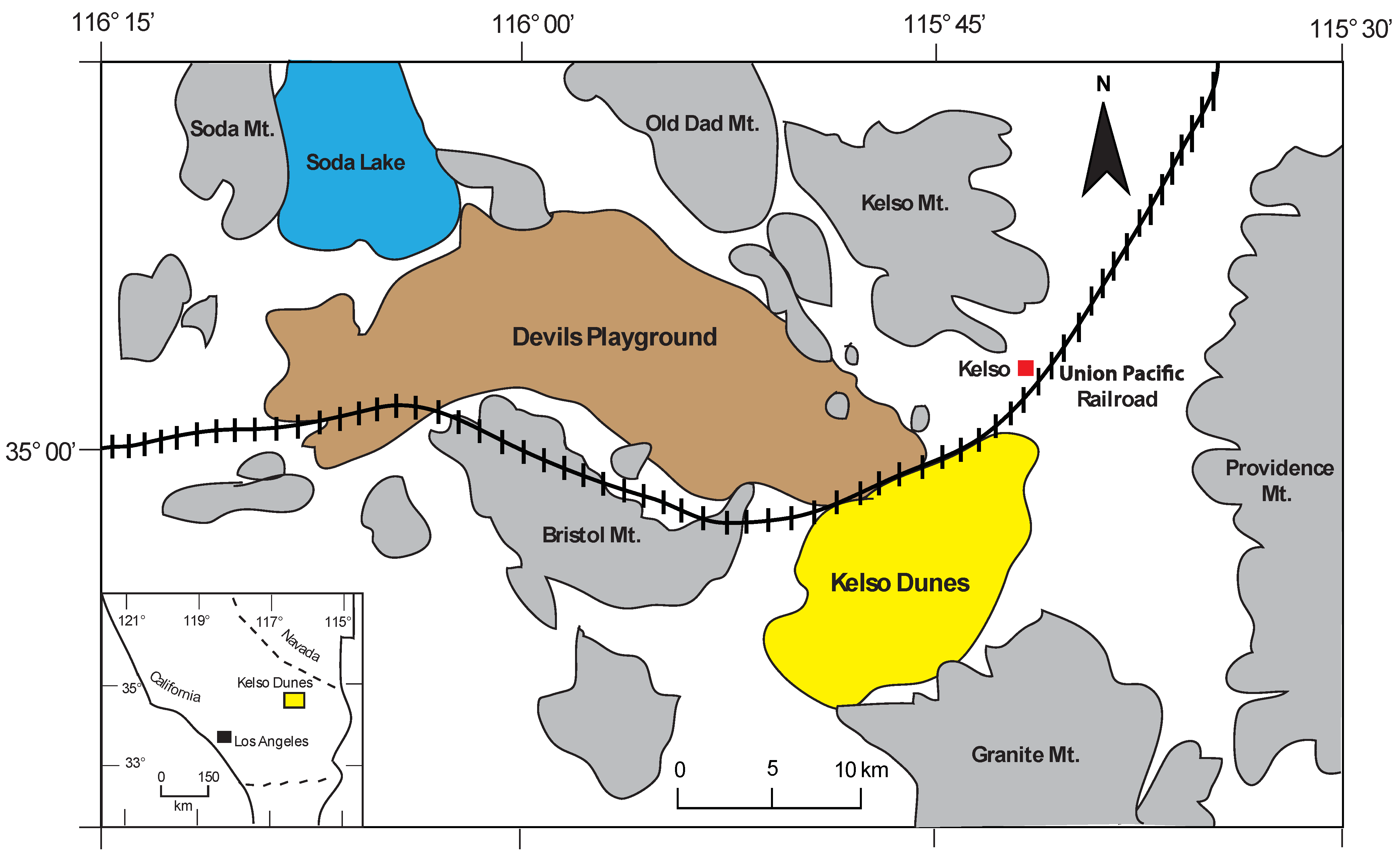
2.1. Study Area

2.2. Data and Analysis
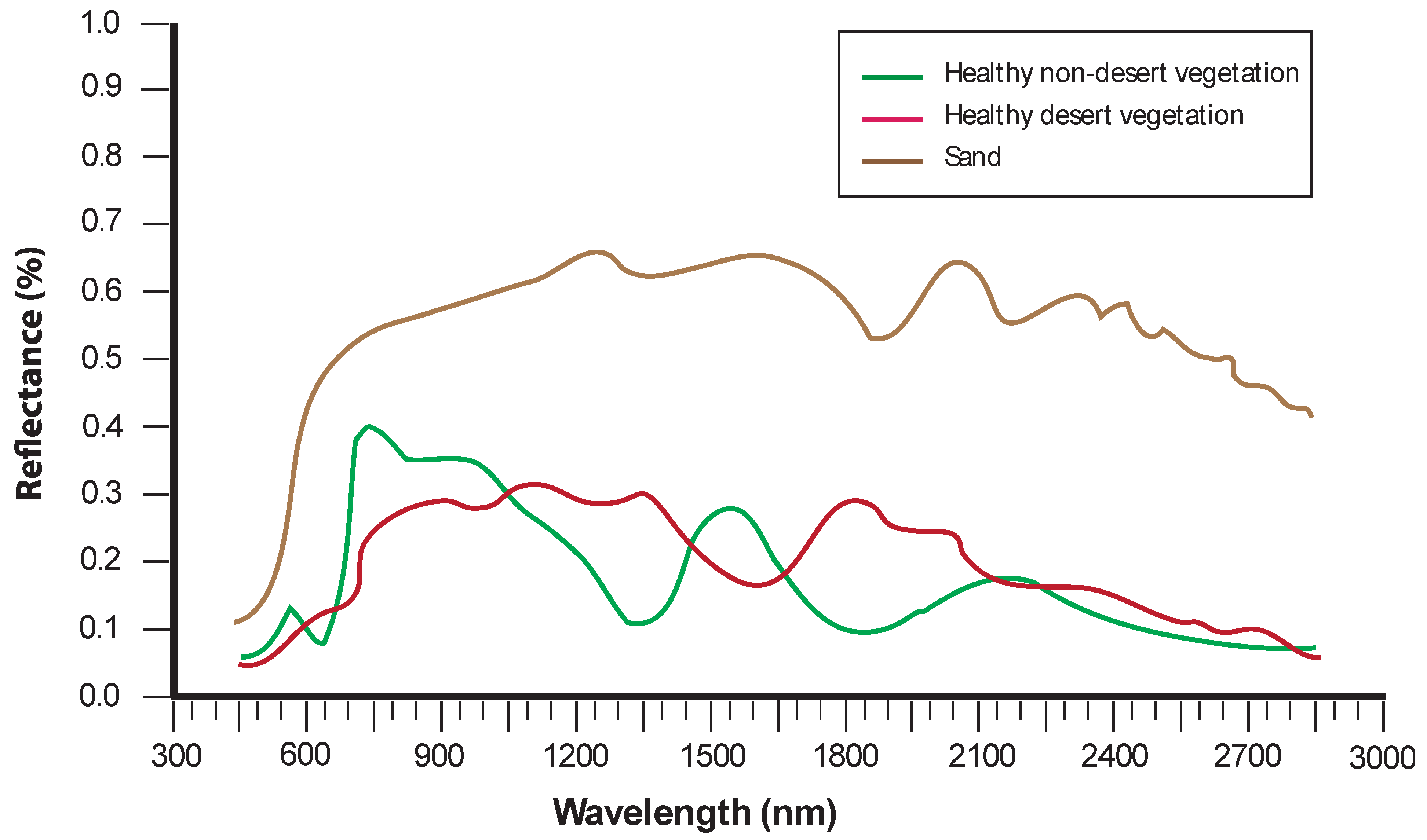
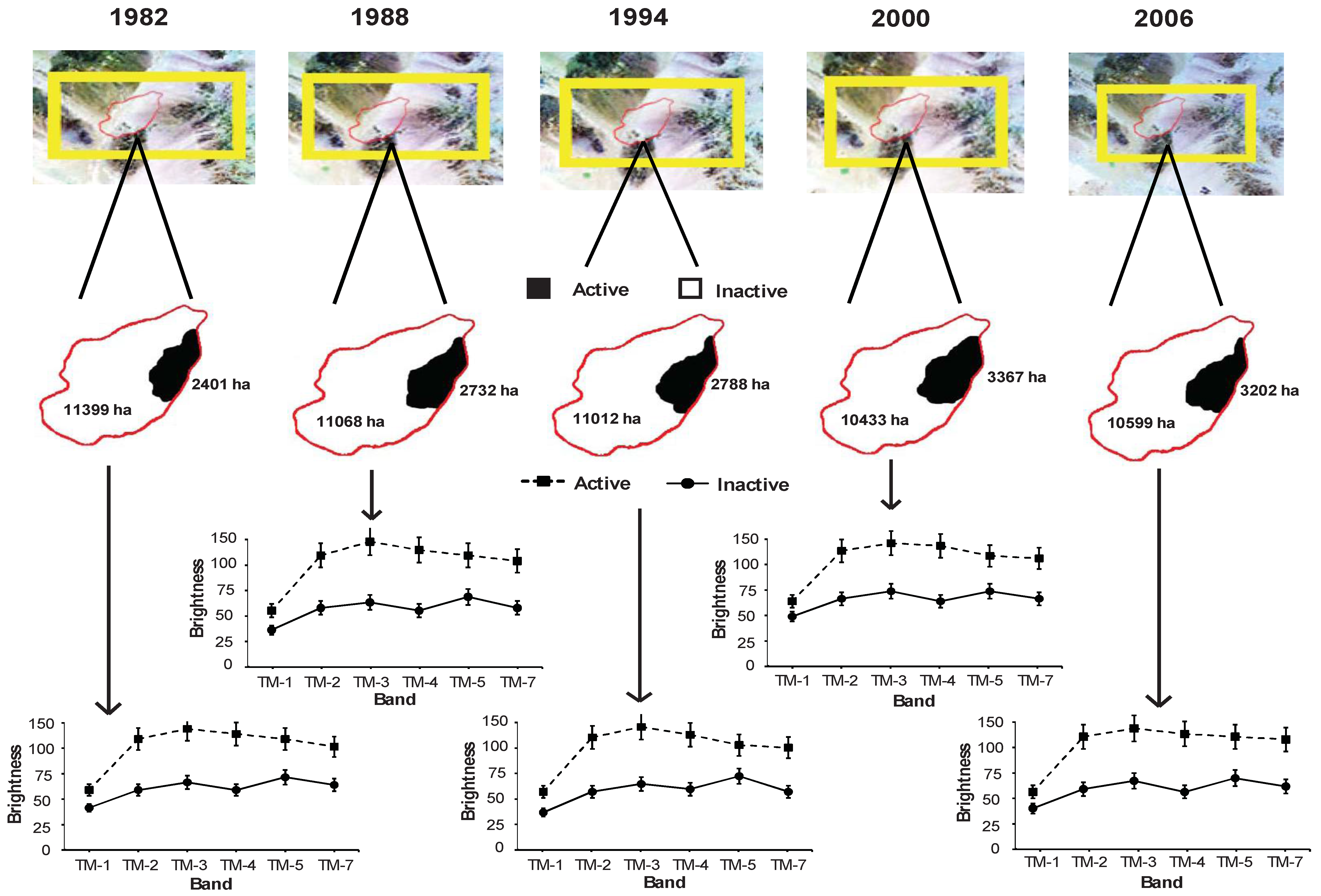
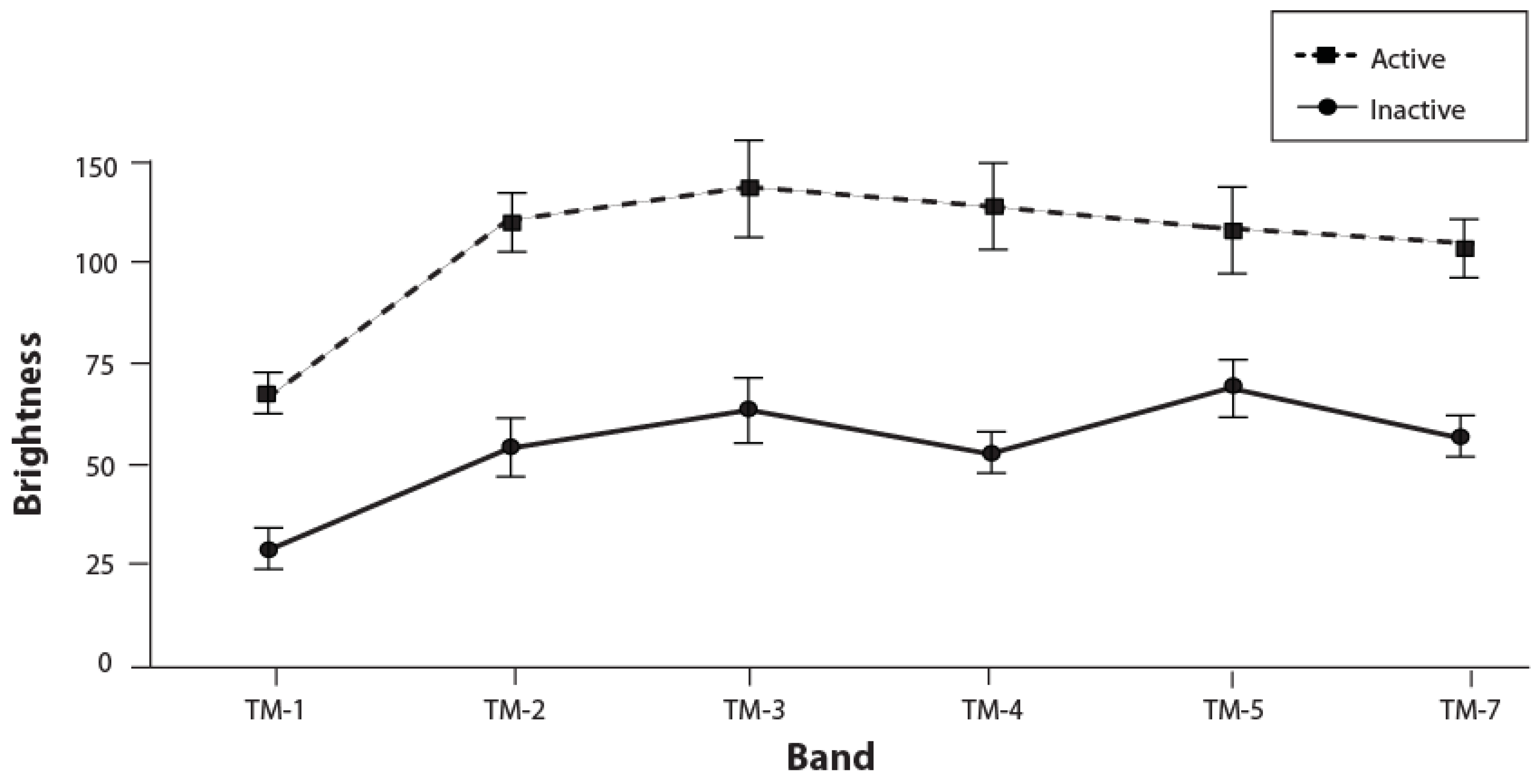
3. Results and Discussion

| Year | Advancement Rate (m3m−1yr−1) |
|---|---|
| 1982 to 1988 | 2.8 |
| 1982 to 1994 | 3.7 |
| 1982 to 2000 | 4.4 |
| 1982 to 2006 | 5.9 |
4. Conclusions
Acknowledgements
References
- Bauer, S.; Stringer, L.C. The role of science in the global governance of desertification. J. Environ. Develop. 2009, 18, 248–267. [Google Scholar] [CrossRef]
- Aubreville, A. La foret coloniale: les forets de l’Afrique occidentale francaise. J. Acad. Sci. Colon. 1938, 9, 35–45. [Google Scholar]
- Collado, A.D.; Chuvieco, E.; Camarasa, A. Satellite remote sensing analysis to monitor desertification processes in the crop-rangeland boundary of Argentina. J. Arid Environ. 2002, 52, 121–133. [Google Scholar] [CrossRef]
- Diouf, A.; Lambin, E.F. Monitoring land-cover changes in semi-arid regions: Remote sensing and field observations in the Ferlo, Senegal. J. Arid Environ. 2001, 48, 129–148. [Google Scholar] [CrossRef]
- Holm, A.M.; Cridland, S.W.; Roderick, M.L. The use of time-integrated NOAA NDVI data and rainfall to assess landscape degradation in the arid shrubland of Western Australia. Remote Sens. Environ. 2003, 85, 145–158. [Google Scholar] [CrossRef]
- Prince, S.D.; de Colstoun, E.B.; Kravitz, L.L. Evidence from Rain-use Efficiencies Does Not Indicate Extensive Sahelian Desertification; Academic Press: San Diego, CA, USA, 1998; pp. 61–78. [Google Scholar]
- Runnstrom, M.C. Is Northern China winning the battle against desertification? Satellite remote sensing as a tool to study biomass trends on the Ordos Plateau in semiarid China. Ambio 2000, 29, 468–476. [Google Scholar]
- Hill, J.; Mégier, J. Imaging Spectrometry—A Tool for Environmental Observations (Eurocourses: Remote Sensing); Springer: New York, NY, USA, 1994; pp. 1–344. [Google Scholar]
- Balduzzi, I.; Bozzano, A.; Corradi, N.; Mariotti, L.M.; Vagge, I. The evolution of the dune fields of Platmona-Marritza (northern Sardinia): Application of remote-sensing methods. Chem. Ecol. 2006, 22, S371–S381. [Google Scholar] [CrossRef]
- del Valle, H.F.; Rostagno, C.M.; Coronato, F.R.; Bouza, P.J.; Blanco, P.D. Sand dune activity in north-eastern Patagonia. J. Arid Environ. 2008, 72, 411–422. [Google Scholar] [CrossRef]
- Paisley, E.C.I.; Lancaster, N.; Gaddis, L.R.; Greeley, R. Discrimination of active and inactive sand from remote sensing: Kelso Dunes, Mojave Desert, California. Remote Sens. Environ. 1991, 37, 153–166. [Google Scholar] [CrossRef]
- Hellden, U. Desertification—Time for an assessment. Ambio 1991, 20, 372–383. [Google Scholar]
- Tucker, C.J.; Dregne, H.E.; Newcomb, W.W. Expansion and contraction of the Sahara Desert from 1980 to 1990. Science 1991, 253, 299–301. [Google Scholar] [CrossRef] [PubMed]
- Jacobberger, P.A. Reflectance characteristics and surface processes in stabilized dune environments. Remote Sens. Environ. 1989, 28, 287–295. [Google Scholar] [CrossRef]
- Otterman, J. Satellite and field studies of man’s impact on the surface in arid regions. Tellus 1981, 33, 68–77. [Google Scholar] [CrossRef]
- Robinove, C.J.; Chavez, P.S.; Gehring, D.; Holmgren, R. Arid land monitoring using Landsat albedo difference images. Remote Sens. Environ. 1981, 11, 133–156. [Google Scholar] [CrossRef]
- Tucker, C.J.; Justice, C.O. Satellite remote sensing of desert spatial extent. Desertification Control Bull. 1986, 13, 2–50. [Google Scholar]
- Ehleringer, J.R. Leaf absorptances of Mohave and Sonoran desert plants. Oecologia 1981, 49, 366–370. [Google Scholar] [CrossRef]
- Huete, R.; Jackson, R.D.; Post, D.F. Spectral response of a plant canopy with different soil backgrounds. Remote Sens. Environ. 1985, 17, 37–53. [Google Scholar] [CrossRef]
- Tueller, P.T. Remote sensing science applications in arid environments. Remote Sens. Environ. 1987, 23, 143–154. [Google Scholar] [CrossRef]
- Collins, W. Remote sensing of crop type and maturity. Photogramm. Eng. Remote Sens. 1978, 44, 43–55. [Google Scholar]
- Ray, T.W.; Murray, B.C. Remote Monitoring of Shifting Sands and Vegetation Cover in Arid Regions. In Proceedings of International Geoscience and Remote Sensing Symposium, Pasadena, CA, USA, August 1994; pp. 1033–1035.
- Ray, T.W.; Murray, B.C. Nonlinear spectral mixing in desert vegetation. Remote Sens. Environ. 1998, 55, 59–64. [Google Scholar] [CrossRef]
- Karnieli, A.; Dall’Olmo, G. Remote sensing monitoring of desertification, phenology, and droughts. Int. J. Manage. Environ. Qual. 2003, 14, 22–38. [Google Scholar] [CrossRef]
- Valor, E.; Caselles, V. Towards the Use of Temperature in Desertification Monitoring: Results of DeMon-I Project; AA Balkema: Rotterdam, The Netherlands, 1997; p. 305. [Google Scholar]
- Blount, H.G.; Greeley, R.; Christensen, P.R.; Arvidson, R. Bright sand/dark dust: The identification of active sand surfaces on the earth and Mars. In Reports of Planetary Geology and Geophysics Program; NASA: Washington, DC, USA, 1986; pp. 257–258. [Google Scholar]
- Breed, C.S.; Grow, T. Morphology and distribution of dunes in sand seas observed by remote sensing. In A Study of Global Sand Seas (USGS Professional Paper1052); McKee, E.D., Ed.; US Government Printing Office: Reston, VA, USA, 1979; pp. 253–302. [Google Scholar]
- Maxwell, T.A.; Haynes, C.V. Remote sensing of sand transport in the Western Desert of Egypt. In Geology of the Arab World; Sadek, A., Ed.; Cairo University: Cario, Egypt, 1992; pp. 19–31. [Google Scholar]
- Thomas, D.S.G.; Leason, H.C. Dunefield activity response to climate variability in the southern Kalahari. Geomorphology 2005, 64, 117–132. [Google Scholar] [CrossRef]
- Katra, I.; Scheidt, S.; Lancaster, N. Changes in active eolian sand at northern Coachella Valley, California. Geomorphology 2009, 105, 277–290. [Google Scholar] [CrossRef]
- Blount, H.G. Regional Aeolian Dynamics from Remote Sensing: Origin of the Gran Desierto, Sonora, Mexico. Ph.D. Thesis, Arizona State University, Tempe, AZ, USA, 1988; pp. 231–268. [Google Scholar]
- Karnieli, A. Development and implementation of spectral crust index over dune sands. Int. J. Remote Sens. 1997, 18, 1207–1220. [Google Scholar] [CrossRef]
- Ben-Dor, E.; Levin, N.; Singer, A.; Karnieli, A.; Braun, O.; Kidron, G.J. Quantitative mapping of the soil rubification process on sand dunes using an airborne hyperspectral sensor. Geoderma 2006, 131, 1–21. [Google Scholar] [CrossRef]
- Ramsey, M.S.; Christensen, P.R.; Lancaster, N.; Howard, D.A. Identification of sand sources and transport pathways at the Kelso Dunes, California, using thermal infrared remote sensing. Geol. Soc. Am. Bull. 1999, 111, 646–662. [Google Scholar] [CrossRef]
- Lancaster, N. Controls on aeolian activity: Some new perspectives from the Kelso dunes, Mojave Desert, California. J. Arid Environ. 1994, 27, 113–125. [Google Scholar] [CrossRef]
- Sharp, R.P. Kelso dunes, Mohave Desert, California. Geol. Soc. Am. Bull. 1966, 77, 1045–1074. [Google Scholar] [CrossRef]
- Lancaster, N. Development of Kelso Dunes, Mojave Desert, California. Nat. Geogr. Res. Explor. 1993, 9, 444–459. [Google Scholar]
- Lancaster, N.; Tchakerian, V.P. Late quaternary eolian dynamics, Mojave Desert, California. In Paleoenvironments and Paleohydrology of the Mojave and Southern Great Basin Deserts; Enzel, Y., Wells, S.G., Lancaster, N., Eds.; The Geological Society of America, Inc.: Boulder, CO, USA, 2003; pp. 231–249. [Google Scholar]
- Lancaster, N.; Wintle, A.G.; Edwards, S.R.; Duller, G.; Tchakerian, V.P. Chronology of eolian activity at Kelso Dunes: Evidence from luminescence dating of dune sediments. GSA Abstract. Prog. 1991, 23, A355. [Google Scholar]
- Ramsey, M.S.; Christensen, P.R.; Lancaster, N.; Howard, D.A. Identification of sand sources and transport pathways at the Kelso Dunes, California using thermal infrared remote sensing. Geol. Soc. Am. Bull. 1999, 111, 646–662. [Google Scholar] [CrossRef]
- Wintle, A.G.; Lancaster, N.; Edwards, S.R. Infrared stimulated luminescence (IRSL) dating of late-Holocene aeolian sands in the Mojave Desert, California, USA. Holocene 1994, 4, 74–78. [Google Scholar] [CrossRef]
- Li, X.R.; Tan, H.J.; He, M.Z.; Wang, X.P.; Li, X.J. Patterns of shrub species richness and abundance in relation to environmental factors on the Alxa Plateau: prerequisites for conserving shrub diversity in extreme arid desert regions. Sci. China Ser. D: Earth Sci. 2009, 52, 669–680. [Google Scholar] [CrossRef]
- Miao, T.D.; Mu, Q.S.; Wu, S.Z. Computer simulation of aeolian sand ripples and dunes. Phys. Lett. A 2001, 288, 16–22. [Google Scholar] [CrossRef]
- Pelletier, J.D. Controls on the height and spacing of eolian ripples and transverse dunes: A numerical modeling investigation. Geomorphology 2009, 105, 322–333. [Google Scholar] [CrossRef]
- Lei, S.A. Soil properties of the Kelso sand dunes in the Mojave Desert. Southwest. Nat. 1993, 43, 47–52. [Google Scholar]
- Chapman, D.M.; Geary, M.; Roy, P.S.; Thorne, B.G. Coastal Evolution and Coastal Erosion in New South Wales; Coastal Council of New South Wales: Sydney, NSW, Australia, 1982; pp. 247–280. [Google Scholar]
- McKee, E.D. Introduction to a study of global sand seas. In A Study of Global Sand Seas; McKee, E.D., Ed.; United States Geological Survey: Reston, VA, USA, 1979; pp. 3–19. [Google Scholar]
- Lindsay, J.B. The Terrain Analysis System: A tool for hydro-geomorphic applications. Hydrol. Processes 2005, 19, 1123–1130. [Google Scholar] [CrossRef]
- Barbour, M.G.; Burk, J.H.; Pitts, W.D.; Gilliam, F.S.; Schwartz, M.W. Terrestrial Plant Ecology, 3rd ed.; Benjamin Cummings, Addison Wesley Longman Inc.: San Francisco, CA, USA, 1999; pp. 38–59. [Google Scholar]
- Congalton, R.G.; Green, K. Assessing the Accuracy of Remotely Sensed Data: Principles and Practices; Lewis Publishers: Boca Raton, FL, USA, 1999; pp. 89–137. [Google Scholar]
- Myint, S.W.; Okin, G.S. Modelling land-cover types using multiple endmember spectral mixture analysis in a desert city. Int. J. Remote Sens. 2009, 30, 2237–2257. [Google Scholar] [CrossRef]
- Smith, H.T.U. Past Versus Present Wind Action in the Mojave Desert Region, California, US; Research Laboratories Publication: New Bedford, MA, USA, 1967; pp. 1–34. [Google Scholar]
- Karnieli, A.; Tsoar, H. Spectral reflectance of biogenic crust developed on desert dune sand along the Israel-Egypt border. Int. J. Remote Sens. 1995, 16, 369–374. [Google Scholar] [CrossRef]
- Yizhaq, H.; Balmforth, N.J.; Provenzale, A. Blown by wind: Nonlinear dynamics of aeolian sand ripples. Physica D 2004, 195, 207–228. [Google Scholar] [CrossRef]
© 2010 by the authors; licensee MDPI, Basel, Switzerland. This article is an open access article distributed under the terms and conditions of the Creative Commons Attribution license (http://creativecommons.org/licenses/by/3.0/).
Share and Cite
Lam, D.K.; Remmel, T.K.; Drezner, T.D. Tracking Desertification in California Using Remote Sensing: A Sand Dune Encroachment Approach. Remote Sens. 2011, 3, 1-13. https://doi.org/10.3390/rs3010001
Lam DK, Remmel TK, Drezner TD. Tracking Desertification in California Using Remote Sensing: A Sand Dune Encroachment Approach. Remote Sensing. 2011; 3(1):1-13. https://doi.org/10.3390/rs3010001
Chicago/Turabian StyleLam, Doris K., Tarmo K. Remmel, and Taly D. Drezner. 2011. "Tracking Desertification in California Using Remote Sensing: A Sand Dune Encroachment Approach" Remote Sensing 3, no. 1: 1-13. https://doi.org/10.3390/rs3010001