How Groundwater Level Fluctuations and Geotechnical Properties Lead to Asymmetric Subsidence: A PSInSAR Analysis of Land Deformation over a Transit Corridor in the Los Angeles Metropolitan Area

 , and
, and
Abstract
:
1. Introduction
- To assess and complement the previous studies on subsidence monitoring in Los Angeles using more recent data.
- To evaluate the PSInSAR results considering soil properties, and hydrological data and GPS information in the area.
- To identify deformation patterns over the study area of the corridor to inform and warn the managers, designers and other stakeholders about the future hazardous consequences.
- To show the variation in displacement rates along the alignment of corridor to help the designers and decision makers of the project to detect the places that require considering immediate solutions to control the current displacements.
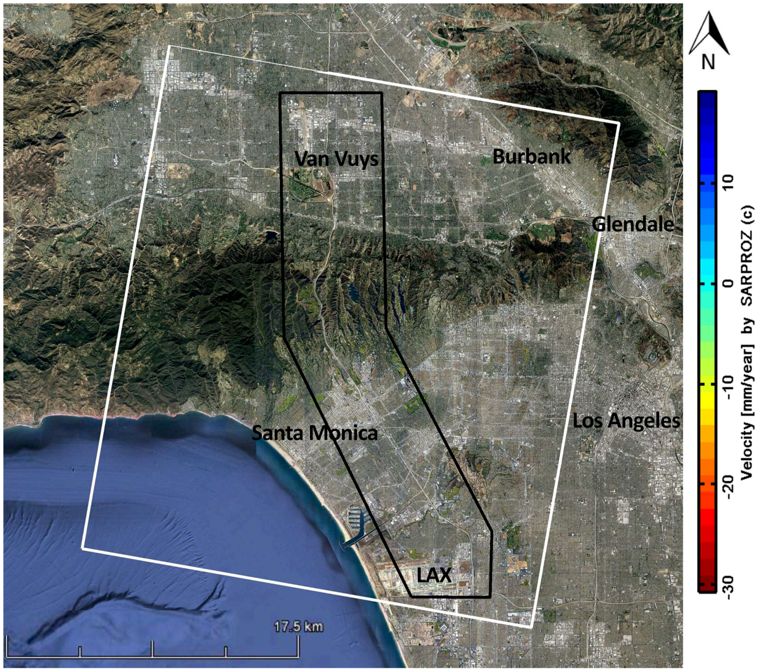
2. Study Area: Sepulveda Transit Corridor, Los Angeles, California
3. Methodology
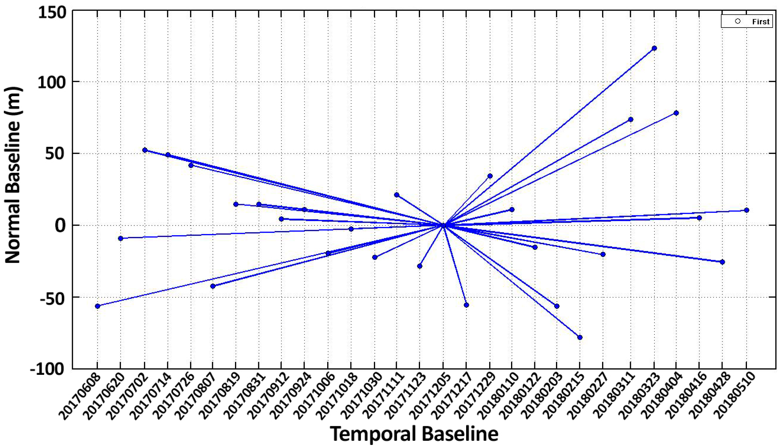
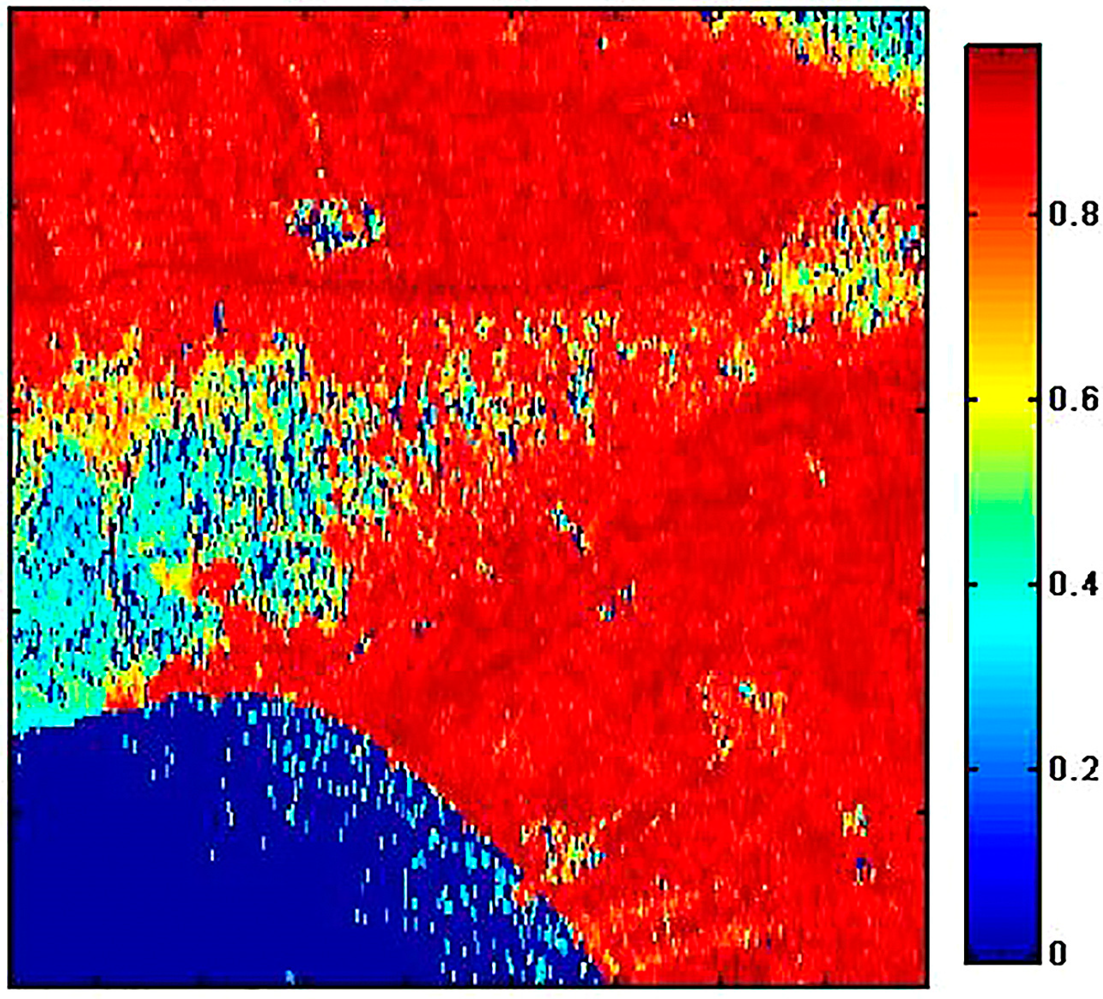
3.1. PSInSAR Time Series Analysis
3.2. Data Collection
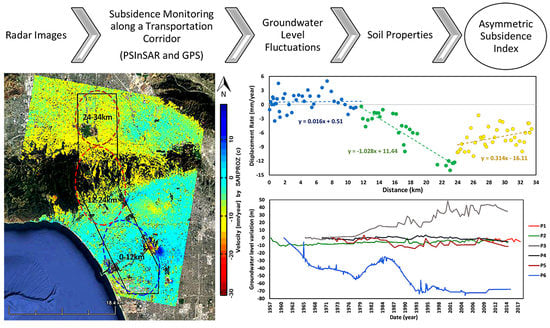
4. Results and Discussion
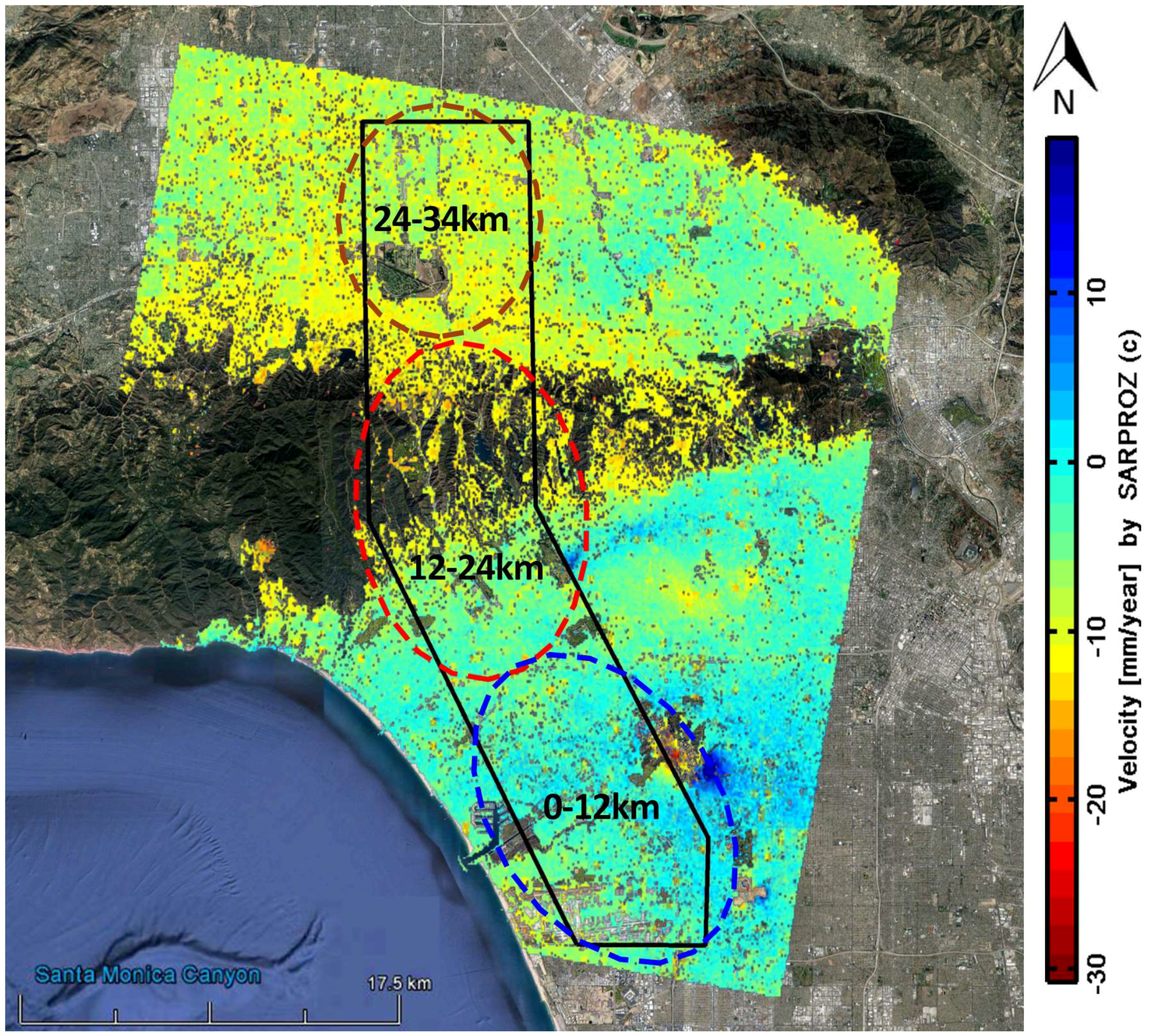
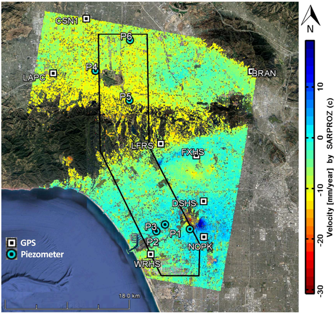
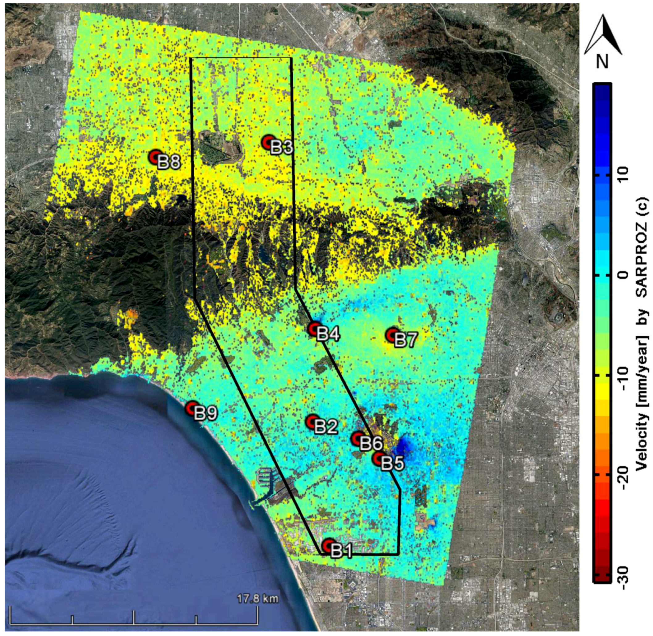
4.1. Ground Deformation
4.2. GPS Monitoring
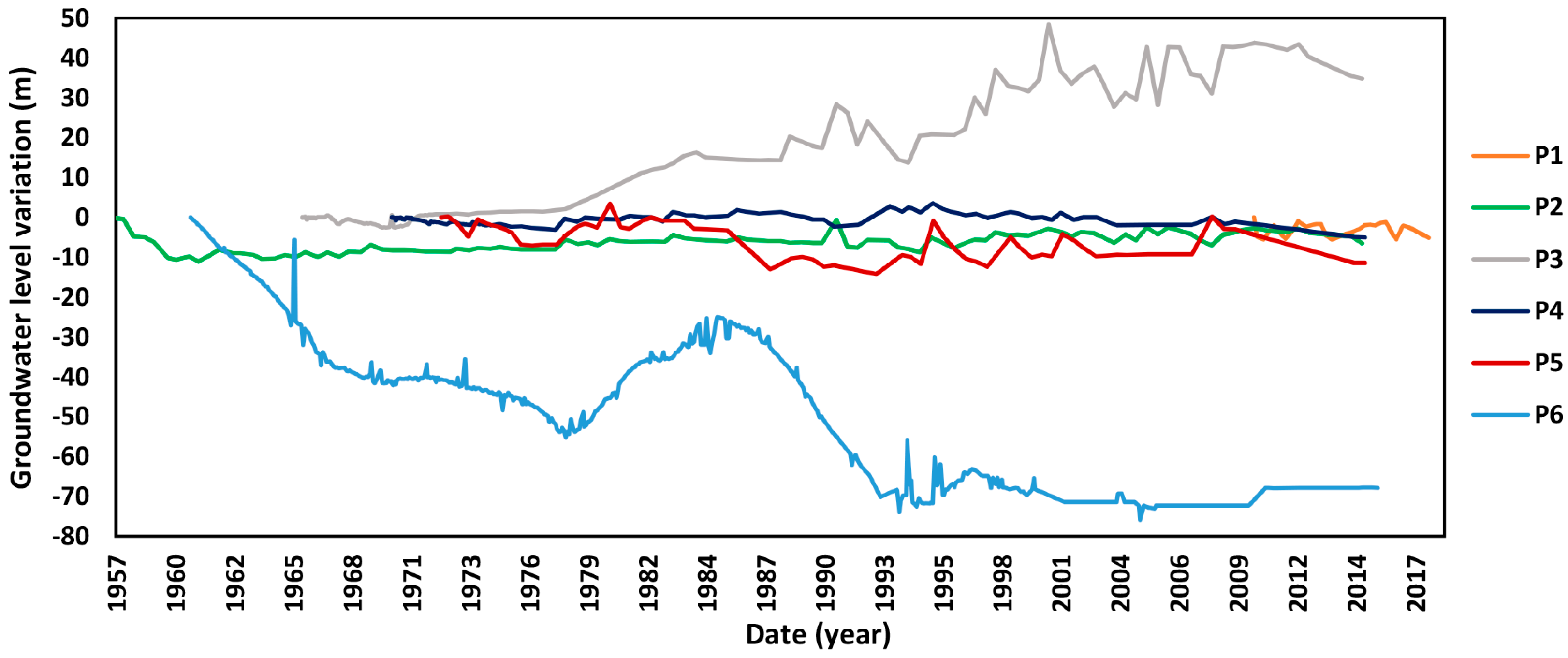
4.3. Monitoring of Groundwater Level Variations
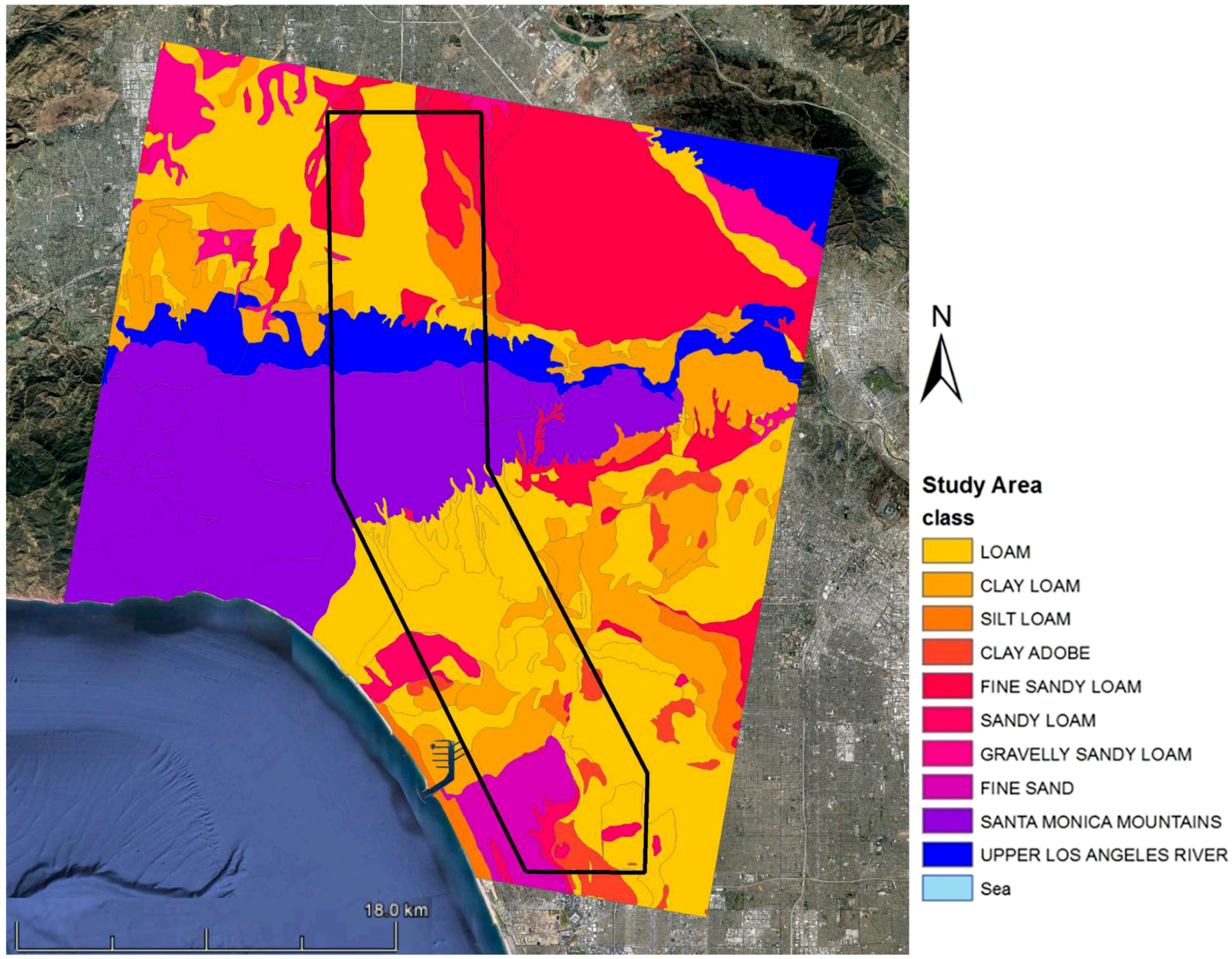
4.4. Geological Characteristics of the Sepulveda Project and Hydrogeology of Basins
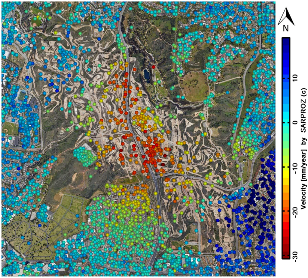
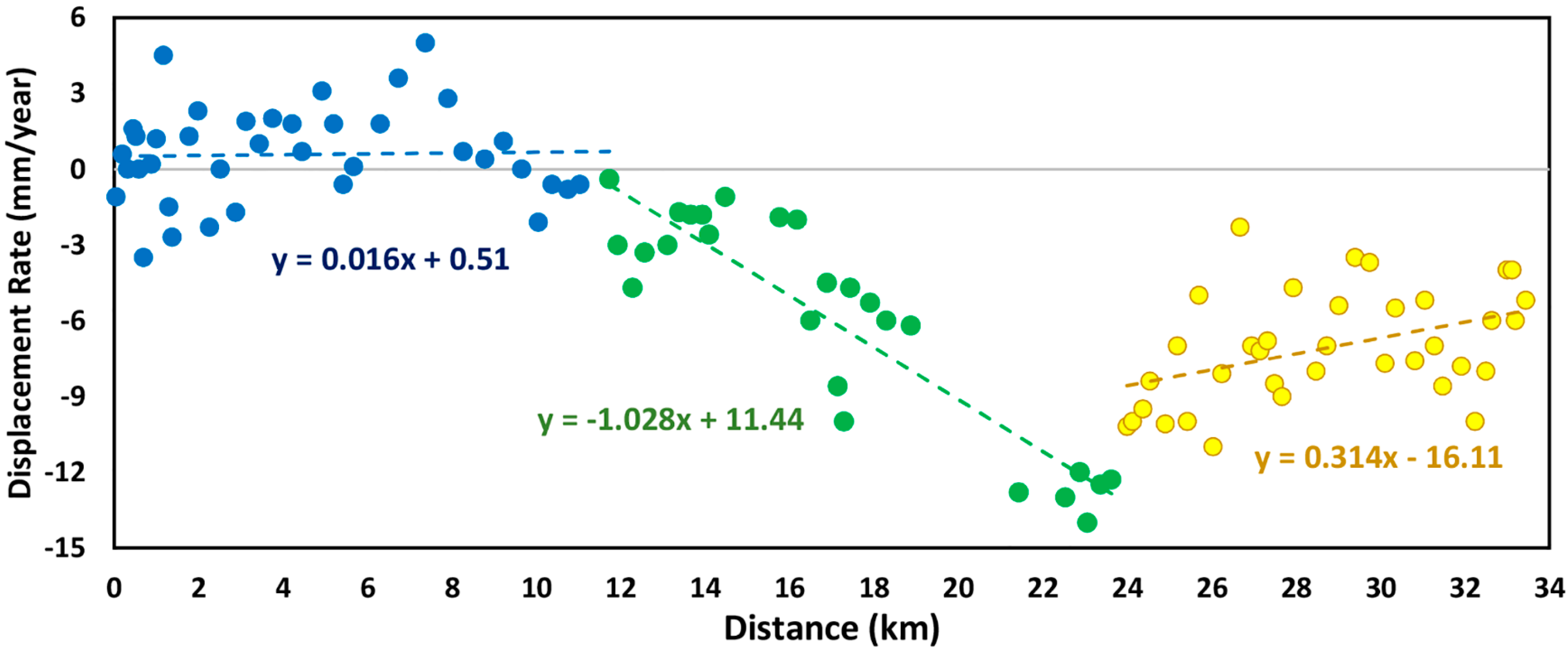
4.5. Asymmetrical Subsidence
5. Conclusions
- The results of this paper showed that the ground subsidence in northern portion of the Sepulveda Transit Corridor is continuous with subsidence rates between 1 and 14 mm/yr and a high-rate of subsidence (30 mm/yr) occurs in the Inglewood field near the south portion of the corridor, which may cause irreversible consequences in the future.
- Based on the variation in displacement rates along the corridor, we categorized the corridor into three zones to help the designers and decision makers of the project to detect the places which require considering solutions to control the probable asymmetric subsidence along the corridor.
- The ground water extraction rate and geotechnical properties in the area both strongly influence the rate and the distribution of subsidence.
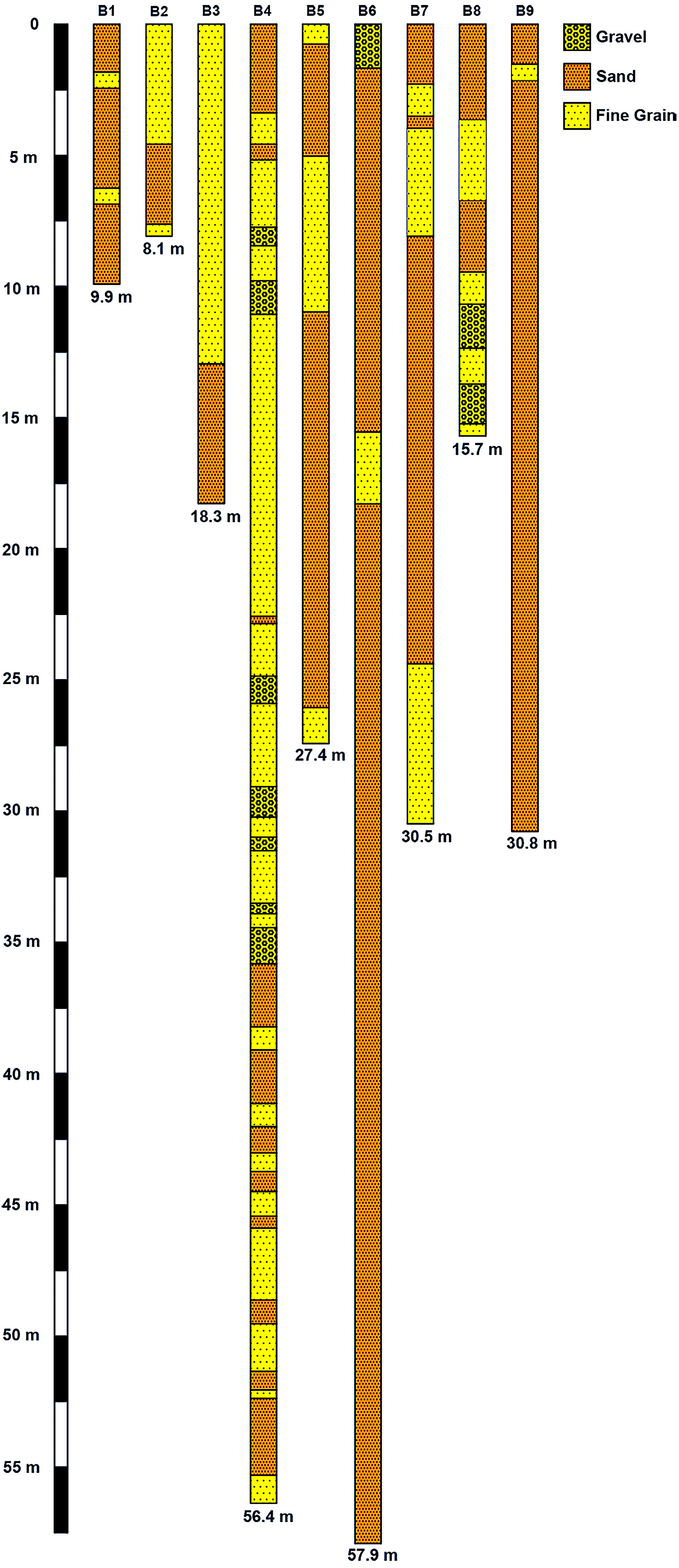
- Collecting deep geotechnical boreholes indicated fine-grained layers in the region. This observation confirmed the necessity of more detailed geotechnical investigations in the interest area.
- There are not a sufficient number of piezometers to detect the groundwater level and accurate in-situ instruments such as GPS stations and extensometers to monitor the land displacements in this area. Therefore, for future researches, we recommend adding more piezometers and instruments particularly in the places suffering from continuous subsidence or uplift.
- Asymmetrical subsidence can be devastating to structures. Because of the heterogeneity of the ground layers, it is difficult to estimate asymmetrical subsidence. So, a simplified framework was proposed based on PSInSAR outputs to evaluate asymmetric subsidence.
Author Contributions
Funding
Acknowledgments
Conflicts of Interest
References
- Bull, W.B.; Poland, J.F. Land Subsidence Due to Ground-Water Withdrawal in the Los Banos-Kettleman City Area, California: Part 3. Interrelations of Water-Level Change, Change in Aquifer-System Thickness, and Subsidence; US Government Printing Office: Washington, DC, USA, 1975; Volume 3.
- Galloway, D.L.; Hudnut, K.W.; Ingebritsen, S.; Phillips, S.P.; Peltzer, G.; Rogez, F.; Rosen, P. Detection of aquifer system compaction and land subsidence using interferometric synthetic aperture radar, Antelope Valley, Mojave Desert, California. Water Resour. Res. 1998, 34, 2573–2585. [Google Scholar] [CrossRef] [Green Version]
- Poland, J.; Davis, G. Subsidence of the land surface in the Tulare—Wasco (Delano) and Los Banos—Kettleman City area, San Joaquin Valley, California. EOS Trans. Am. Geophys. Union 1956, 37, 287–296. [Google Scholar] [CrossRef]
- Perissin, D.; Wang, Z.; Wang, T. The SARPROZ InSAR tool for urban subsidence/manmade structure stability monitoring in China. In Proceedings of the 34th International Symposium on Remote Sensing of Environment, Sydney, Australia, 10–15 April 2011. [Google Scholar]
- Osmanoğlu, B.; Dixon, T.H.; Wdowinski, S.; Cabral-Cano, E.; Jiang, Y. Mexico City subsidence observed with persistent scatterer InSAR. Int. J. Appl. Earth Obs. 2011, 13, 1–12. [Google Scholar] [CrossRef]
- López-Quiroz, P.; Doin, M.-P.; Tupin, F.; Briole, P.; Nicolas, J.-M. Time series analysis of Mexico City subsidence constrained by radar interferometry. J. Appl. Geophys. 2009, 69, 1–15. [Google Scholar] [CrossRef]
- Chai, J.C.; Shen, S.L.; Zhu, H.H.; Zhang, X.L. Land subsidence due to groundwater drawdown in Shanghai. Geotechnique 2004, 54, 143–147. [Google Scholar] [CrossRef]
- Shen, S.L.; Xu, Y.S. Numerical evaluation of land subsidence induced by groundwater pumping in Shanghai. Can. Geotech. J. 2011, 48, 1378–1392. [Google Scholar] [CrossRef]
- Shen, S.L.; Ma, L.; Xu, Y.S.; Yin, Z.Y. Interpretation of increased deformation rate in aquifer IV due to groundwater pumping in Shanghai. Can. Geotech. J. 2013, 50, 1129–1142. [Google Scholar] [CrossRef]
- Maghsoudi, Y.; van der Meer, F.; Hecker, C.; Perissin, D.; Saepuloh, A. Using PS-InSAR to detect surface deformation in geothermal areas of West Java in Indonesia. Int. J. Appl. Earth Obs. 2017. [Google Scholar] [CrossRef]
- Abidin, H.Z.; Andreas, H.; Gumilar, I.; Fukuda, Y.; Pohan, Y.E.; Deguchi, T. Land subsidence of Jakarta (Indonesia) and its relation with urban development. Nat. Hazards 2011, 59, 1753. [Google Scholar] [CrossRef]
- Chaussard, E.; Amelung, F.; Abidin, H.; Hong, S.-H. Sinking cities in Indonesia: ALOS PALSAR detects rapid subsidence due to groundwater and gas extraction. Remote Sens. Environ. 2013, 128, 150–161. [Google Scholar] [CrossRef]
- Marfai, M.A.; King, L. Monitoring land subsidence in Semarang, Indonesia. Environ. Geol. 2007, 53, 651–659. [Google Scholar] [CrossRef]
- Teatini, P.; Ferronato, M.; Gambolati, G.; Bertoni, W.; Gonella, M. A century of land subsidence in Ravenna, Italy. Environ. Geol. 2005, 47, 831–846. [Google Scholar] [CrossRef]
- Stramondo, S.; Saroli, M.; Tolomei, C.; Moro, M.; Doumaz, F.; Pesci, A.; Loddo, F.; Baldi, P.; Boschi, E. Surface movements in Bologna (Po plain—Italy) detected by multitemporal DInSAR. Remote Sens. Environ. 2007, 110, 304–316. [Google Scholar] [CrossRef]
- Raucoules, D.; Le Mouélic, S.; Carnec, C.; Maisons, C.; King, C. Urban subsidence in the city of Prato (Italy) monitored by satellite radar interferometry. Int. J. Remote Sens. 2003, 24, 891–897. [Google Scholar] [CrossRef]
- Rosi, A.; Tofani, V.; Agostini, A.; Tanteri, L.; Stefanelli, C.T.; Catani, F.; Casagli, N. Subsidence mapping at regional scale using persistent scatters interferometry (PSI): The case of Tuscany region (Italy). Int. J. Appl. Earth Obs. 2016, 52, 328–337. [Google Scholar] [CrossRef]
- Del Soldato, M.; Farolfi, G.; Rosi, A.; Raspini, F.; Casagli, N. Subsidence evolution of the Firenze–Prato–Pistoia plain (Central Italy) combining PSI and GNSS data. Remote Sens. 2018, 10, 1146. [Google Scholar] [CrossRef]
- Motagh, M.; Djamour, Y.; Walter, T.R.; Wetzel, H.U.; Zschau, J.; Arabi, S. Land subsidence in Mashhad Valley, northeast Iran: results from InSAR, levelling and GPS. Geophys. J. Int. 2007, 168, 518–526. [Google Scholar] [CrossRef] [Green Version]
- Akbari, V.; Motagh, M. Improved ground subsidence monitoring using small baseline SAR interferograms and a weighted least squares inversion algorithm. IEEE Geosci. Remote Sens. 2012, 9, 437–441. [Google Scholar] [CrossRef]
- Dehghani, M.; Valadan Zoej, M.J.; Entezam, I.; Mansourian, A.; Saatchi, S. InSAR monitoring of progressive land subsidence in Neyshabour, northeast Iran. Geophys. J. Int. 2009, 178, 47–56. [Google Scholar] [CrossRef] [Green Version]
- Motagh, M.; Shamshiri, R.; Haghighi, M.H.; Wetzel, H.-U.; Akbari, B.; Nahavandchi, H.; Roessner, S.; Arabi, S. Quantifying groundwater exploitation induced subsidence in the Rafsanjan plain, southeastern Iran, using InSAR time-series and in situ measurements. Eng. Geol. 2017, 218, 134–151. [Google Scholar] [CrossRef]
- Sadeghi, Z.; Zoej, M.J.V.; Dehghani, M.; Chang, N.B. Enhanced algorithm based on persistent scatterer interferometry for the estimation of high-rate land subsidence. J. Appl. Remote Sens. 2012, 6. [Google Scholar] [CrossRef]
- Khorrami, M.; Abrishami, S.; Maghsoudi, Y. Mashhad Subsidence Monitoring by Interferometric Synthetic Aperture Radar Technique. AUT J. Civ. Eng. 2018. [Google Scholar] [CrossRef]
- Foroughnia, F.; Nemati, S.; Maghsoudi, Y.; Perissin, D. An iterative PS-InSAR method for the analysis of large spatio-temporal baseline data stacks for land subsidence estimation. Int. J. Appl. Earth Obs. 2019, 74, 248–258. [Google Scholar] [CrossRef]
- Hu, J.; Ding, X.L.; Li, Z.W.; Zhang, L.; Zhu, J.J.; Sun, Q.; Gao, G.J. Vertical and horizontal displacements of Los Angeles from InSAR and GPS time series analysis: Resolving tectonic and anthropogenic motions. J. Geodyn. 2016, 99, 27–38. [Google Scholar] [CrossRef]
- Perissin, D. Interferometric SAR Multitemporal Processing: Techniques and Applications. In Multitemporal Remote Sensing; Springer: New York, NY, USA, 2016; pp. 145–176. [Google Scholar] [CrossRef]
- Lanari, R.; Lundgren, P.; Manzo, M.; Casu, F. Satellite radar interferometry time series analysis of surface deformation for Los Angeles, California. Geophys. Res. Lett. 2004, 31. [Google Scholar] [CrossRef] [Green Version]
- Watson, K.M.; Bock, Y.; Sandwell, D.T. Satellite interferometric observations of displacements associated with seasonal groundwater in the Los Angeles basin. J. Geophys. Res.-Sol. Earth 2002, 107. [Google Scholar] [CrossRef]
- Zhang, L.; Lu, Z.; Ding, X.; Jung, H.S.; Feng, G.; Lee, C.W. Mapping ground surface deformation using temporarily coherent point SAR interferometry: Application to Los Angeles Basin. Remote Sens. Environ. 2012, 117, 429–439. [Google Scholar] [CrossRef]
- Borchers, J.W.; Carpenter, M.; Grabert, V.; Dalgish, B.; Cannon, D. Land subsidence from groundwater use in California. In California Water Foundation Full Report of Findings; California Water Foundation: Sacramento, CA, USA, 2014; p. 151. [Google Scholar]
- Khorrami, M.; Hatami, M.; Alizadeh, B.; Khorrami, H.; Rahgozar, P.; Flood, I. Impact of Ground Subsidence on Groundwater Quality: A Case Study in Los Angeles, California. In Proceedings of the 2019 ASCE International Conference on Computing in Civil Engineering, Atlanta, GA, USA, 17–19 June 2019. (In Press). [Google Scholar]
- Nikvar Hassani, A.; Katibeh, H.; Farhadian, H. Numerical analysis of steady-state groundwater inflow into Tabriz line 2 metro tunnel, northwestern Iran, with special consideration of model dimensions. Bull. Eng. Geol. Environ. 2016, 75, 1617–1627. [Google Scholar] [CrossRef]
- Rowe, R.K.; Lee, K.M. Subsidence owing to tunnelling. II. Evaluation of a prediction technique: Reply. Can. Geotech. J. 1994, 31, 467–469. [Google Scholar] [CrossRef]
- Sharma, J.R.; Najafi, M.; Marshall, D.; Kaushal, V.; Hatami, M. Development of A Model For Estimation of Buried Large Diameter Thin-walled Steel Pipe Deflection Due To External Loads “In Press”. J. Pipeline Syst. Eng. 2019. [Google Scholar] [CrossRef]
- Hatami, M.; Ameri Siahooei, E. Examines criteria applicable in the optimal location new cities, with approach for sustainable urban development. Middle-East J. Sci. Res. 2013, 14, 734–743. [Google Scholar]
- Riding, K.A.; Peterman, R.J.; Guthrie, S.; Brueseke, M.; Mosavi, H.; Daily, K.; Risovi-Hendrickson, W. Environmental and Track Factors That Contribute to Abrasion Damage. In Proceedings of the 2018 Joint Rail Conference, Pittsburgh, PA, USA, 18–20 April 2018. [Google Scholar]
- Shi, Y.J.; Li, M.G.; Chen, J.J.; Wang, J.H. Long-Term Settlement Behavior of a Highway in Land Subsidence Area. J. Perform. Constr. Fac. 2018, 32. [Google Scholar] [CrossRef]
- Lahijanian, B.; Zarandi, M.F.; Farahani, F.V. Double coverage ambulance location modeling using fuzzy traveling time. In Proceedings of the Fuzzy Information Processing Society (NAFIPS), 2016 Annual Conference of the North American, El Paso, TX, USA, 31 October–4 November 2016; pp. 1–6. [Google Scholar]
- Argus, D.F.; Heflin, M.B.; Peltzer, G.; Crampé, F.; Webb, F.H. Interseismic strain accumulation and anthropogenic motion in metropolitan Los Angeles. J. Geophys. Res.-Sol. Earth 2005, 110. [Google Scholar] [CrossRef] [Green Version]
- Gens, R.; Van Genderen, J.L. Review Article SAR interferometry—Issues, techniques, applications. Int. J. Remote Sens. 1996, 17, 1803–1835. [Google Scholar] [CrossRef]
- Klees, R.; Massonnet, D. Deformation measurements using SAR interferometry: potential and limitations. Geologie en Mijnbouw 1998, 77, 161–176. [Google Scholar] [CrossRef]
- Smith, L.C. Emerging applications of interferometric synthetic aperture radar (InSAR) in geomorphology and hydrology. Ann. Assoc. Am. Geogr. 2002, 92, 385–398. [Google Scholar] [CrossRef]
- Alsdorf, D.E.; Melack, J.M.; Dunne, T.; Mertes, L.A.; Hess, L.L.; Smith, L.C. Interferometric radar measurements of water level changes on the Amazon flood plain. Nature 2000, 404, 174. [Google Scholar] [CrossRef]
- Peduto, D.; Huber, M.; Speranza, G.; van Ruijven, J.; Cascini, L. DInSAR data assimilation for settlement prediction: case study of a railway embankment in the Netherlands. Can. Geotech. J. 2016, 54, 502–517. [Google Scholar] [CrossRef]
- Daghighi, A.; Nahvi, A.; Kim, U. Optimal Cultivation Pattern to Increase Revenue and Reduce Water Use: Application of Linear Programming to Arjan Plain in Fars Province. Agriculture 2017, 7, 73. [Google Scholar] [CrossRef]
- Hooper, A.; Bekaert, D.; Spaans, K.; Arıkan, M. Recent advances in SAR interferometry time series analysis for measuring crustal deformation. Tectonophysics 2012, 514, 1–13. [Google Scholar] [CrossRef]
- Bayer, B.; Simoni, A.; Schmidt, D.; Bertello, L. Using advanced InSAR techniques to monitor landslide deformations induced by tunneling in the Northern Apennines, Italy. Eng. Geol. 2017, 226, 20–32. [Google Scholar] [CrossRef]
- Shafieardekani, M.; Hatami, M. Forecasting Land Use Change in suburb by using Time series and Spatial Approach; Evidence from Intermediate Cities of Iran. Eur. J. Sci. Res. 2013, 116, 199–208. [Google Scholar]
- Perissin, D.; Wang, Z.; Lin, H. Shanghai subway tunnels and highways monitoring through Cosmo-SkyMed Persistent Scatterers. ISPRS J. Photogr. 2012, 73, 58–67. [Google Scholar] [CrossRef]
- Lundgren, P.; Hetland, E.A.; Liu, Z.; Fielding, E.J. Southern San Andreas—San Jacinto fault system slip rates estimated from earthquake cycle models constrained by GPS and interferometric synthetic aperture radar observations. J. Geophys. Res.-Sol. Earth 2009, 114. [Google Scholar] [CrossRef]
- Wei, M.; Sandwell, D.; Smith-Konter, B. Optimal combination of InSAR and GPS for measuring interseismic crustal deformation. Adv. Space Res. 2010, 46, 236–249. [Google Scholar] [CrossRef]
- Bawden, G.W.; Thatcher, W.; Stein, R.S.; Hudnut, K.W.; Peltzer, G. Tectonic contraction across Los Angeles after removal of groundwater pumping effects. Nature 2001, 412, 812. [Google Scholar] [CrossRef] [PubMed]
- Riel, B.; Simons, M.; Ponti, D.; Agram, P.; Jolivet, R. Quantifying ground deformation in the Los Angeles and Santa Ana Coastal Basins due to groundwater withdrawal. Water Resour. Res. 2018, 54, 3557–3582. [Google Scholar] [CrossRef]
- Sharma, P.; Jones, C.E.; Dudas, J.; Bawden, G.W.; Deverel, S. Monitoring of subsidence with UAVSAR on Sherman Island in California’s Sacramento–San Joaquin Delta. Remote Sens. Environ. 2016, 181, 218–236. [Google Scholar] [CrossRef]
- Jeanne, P.; Farr, T.G.; Rutqvist, J.; Vasco, D.W. Role of agricultural activity on land subsidence in the San Joaquin Valley, California. J. Hydrol. 2019, 569, 462–469. [Google Scholar] [CrossRef]
- Tapete, D.; Morelli, S.; Fanti, R.; Casagli, N. Localising deformation along the elevation of linear structures: An experiment with space-borne InSAR and RTK GPS on the Roman Aqueducts in Rome, Italy. Appl. Geogr. 2015, 58, 65–83. [Google Scholar] [CrossRef] [Green Version]
- Bekaert, D.; Hamlington, B.; Buzzanga, B.; Jones, C. Spaceborne Synthetic Aperture Radar Survey of Subsidence in Hampton Roads, Virginia (USA). Sci. Rep.-UK 2017, 7, 14752. [Google Scholar] [CrossRef] [PubMed] [Green Version]
- Rabus, B.; Eppler, J.; Sharma, J.; Busler, J. Tunnel monitoring with an advanced InSAR technique. In Proceedings of the Radar Sensor Technology XVI, Baltimore, MD, USA, 23–25 April 2012; p. 83611F. [Google Scholar]
- Nahvi, A.; Daghighi, A.; Nazif, S. The environmental impact assessment of drainage systems: a case study of the Karun river sugarcane development project. Arch. Agron. Soil Sci. 2018, 64, 185–195. [Google Scholar] [CrossRef]
- Davidson, M.; Attema, E.; Rommen, B.; Floury, N.; Partricio, L.; Levrini, G. ESA sentinel-1 SAR mission concept. In Proceedings of the EUSAR, Dresden, Germany, 16–18 May2006. [Google Scholar]
- Metro. Webpage of Sepulveda Transit Corridor Project. Available online: https://www.metro.net/projects/sepulvedacorridor/ (accessed on 5 August 2018).
- Ferretti, A.; Prati, C.; Rocca, F. Permanent scatterers in SAR interferometry. IEEE Trans. Geosci. Remote 2001, 39, 8–20. [Google Scholar] [CrossRef] [Green Version]
- Canaslan Comut, F.; Ustun, A.; Lazecky, M.; Perissin, D. Capability of Detecting Rapid Subsidence with COSMO SKYMED and Sentinel-1 Dataset over Konya City. In Proceedings of the Living Planet Symposium, Prague, Czech Republic, 9–13 May 2016; p. 295. [Google Scholar]
- Perrone, G.; Morelli, M.; Piana, F.; Fioraso, G.; Nicolò, G.; Mallen, L.; Cadoppi, P.; Balestro, G.; Tallone, S. Current tectonic activity and differential uplift along the Cottian Alps/Po Plain boundary (NW Italy) as derived by PS-InSAR data. J. Geodyn. 2013, 66, 65–78. [Google Scholar] [CrossRef] [Green Version]
- Hanssen, R.F. Radar Interferometry: Data Interpretation and Error Analysis; Springer Science & Business Media: New York, NY, USA, 2001; Volume 2. [Google Scholar]
- Ferretti, A.; Prati, C.; Rocca, F. Nonlinear subsidence rate estimation using permanent scatterers in differential SAR interferometry. IEEE Trans. Geosci. Remote 2000, 38, 2202–2212. [Google Scholar] [CrossRef]
- Colesanti, C.; Ferretti, A.; Novali, F.; Prati, C.; Rocca, F. SAR monitoring of progressive and seasonal ground deformation using the permanent scatterers technique. IEEE Trans. Geosci. Remote 2003, 41, 1685–1701. [Google Scholar] [CrossRef]
- Murray, J.R.; Svarc, J. Global Positioning System data collection, processing, and analysis conducted by the US Geological Survey Earthquake Hazards Program. Seismol. Res. Lett. 2017, 88, 916–925. [Google Scholar] [CrossRef]
- Metro. Final Compendium Report of Sepulveda Transit Corridor: Appendix B, Geotechnical Evaluation Memorandum; The Los Angeles County Metropolitan Transportation Authority: Los Angeles, CA, USA, 2012. [Google Scholar]
- CGS. California Geological Survey: Seismic Hazard Zones, Beverly Hills Quadrangle, Official Map; CGS: Sacramento, CA, USA, 1999.
- CGS. California Geological Survey: Seismic Hazard Zone Report for the Van Nuys 7.5-Minute Quadrangle; CGS: Sacramento, CA, USA, 1997.
- CGS. California Geological Survey: Seismic Hazard Zone Report for the Venice 7.5-Minute Quadrangle; CGS: Sacramento, CA, USA, 1998.
- California’s Groundwater. Groundwater Basin Number: 4-12, San Fernando Valley Groundwater Basin, Bulletin 118; California’s Groundwater, 2004. Available online: https://www.bhusd.org/pdf/seismic_reports//____36_Leighton%20El%20Rodeo%20Geohazards%20Report_3-2-15.pdf (accessed on 8 September 2018).
- California’s Groundwater. Groundwater Basin Number: 4-11.01, Coastal Plain of Los Angeles Groundwater Basin, Santa Monica Subbasin, Bulletin 118; California’s Groundwater, 2004. Available online: http://www.water.ca.gov/groundwater/bulletin118/basindescriptions/4-11.01.pdf (accessed on 12 September 2018).
- LADWP. Feasibility Report for Development of Groundwater Resources in the Santa Monica and Hollywood Basins; LADWP: Los Angeles, CA, USA, 2011. [Google Scholar]
- Poland, J.F.; Garrett, A.A.; Sinnott, A. Geology, Hydrology, and Chemical Character of Ground Waters in the Torrance-Santa Monica Area, California; US Government Printing Office: Washington, DC, USA, 1959.
- Norris, R.M.; Webb, R.W. Geology of California; John Wiley & Sons Inc.: Hoboken, NJ, USA, 1990. [Google Scholar]
- Ninyo & Moore Geotechnical & Environmental Sciences Consultants. Geotechnical Evaluation Sepulveda Feeder Interconnection Project Culver City, California. 2009. Available online: https://dpw.lacounty.gov/wwd/web/Documents/Reports/Sepulveda%20Feeder%20Service%20Connection.pdf (accessed on 7 August 2018).
- Shannon & Wilson, Inc. Geology and Soil Discipline Report: the Academy Museum of Motion Picture, Los Angeles. 2014. Available online: https://planning.lacity.org/eir/AcademyMuse_MotionPictures/DEIR/DEIR/Technical_Appendices/Appendix_H-1_Methane_Report.pdf (accessed on 14 June 2018).
- Geotechnologies, Inc. Geotechnical Report: Geotechnical Engineering Investigation Proposed Mixed-Use Development 6001–6059 Van Nuys Boulevard, Van Nuys, California. 2015. Available online: https://planning.lacity.org/eir/nops/6001VanNuys/appendixa.pdf (accessed on May 2018).
- Leighton Consulting, Inc. Geohazard Report: El Rodeo K-8 School 605 Whittier Drive, Beverly Hills, Los Angeles. 2015. Available online: https://www.bhusd.org/pdf/seismic_reports//____36_Leighton%20El%20Rodeo%20Geohazards%20Report_3-2-15.pdf (accessed on 16 June 2018).
- Ninyo & Moore Geotechnical & Environmental Sciences Consultants. Runway 25R Reconstruction Project: Runway 25R-7L Improvements, Los Angeles International Airport (LAX), California. 2017. Available online: http://www.labavn.org/contracts/documents/81/30368/Runway%2025R%20Reconstruction%20RFB.pdf (accessed on 19 April 2018).
- SCS Engineers, Inc. Groundwater Monitoring Program, Inglewood Field. 2018. Available online: https://inglewoodoilfield.com/csd-related-plans (accessed on 2 April 2018).
- Hodgkinson, K.M.; Stein, R.S.; Hudnut, K.W.; Satalich, J.; Richards, J.H. Damage and Restoration of Geodetic Infrastructure Caused by the 1994 Northridge, California, Earthquake; US Geological Survey: Reston, VA, USA, 1996.
- Martz, P. Asymmetrical Subsidence Resulting from Material and Fluid Extraction. 2009. Available online: https://open.library.ubc.ca/media/download/pdf/52966/1.0053573/1 (accessed on 23 May 2018).
- Jozaghi, A.; Alizadeh, B.; Hatami, M.; Flood, I.; Khorrami, M.; Khodaei, N.; Ghasemi Tousi, E. A Comparative Study of the AHP and TOPSIS Techniques for Dam Site Selection Using GIS: A Case Study of Sistan and Baluchestan Province, Iran. Geosciences 2018, 8, 494. [Google Scholar] [CrossRef]
- Hatami, M.; Shafieardekani, M. The Effect of Industrialization on Land Use Changes; Evidence from Intermediate Cities of Iran. Int. J. Curr. Life Sci. 2014, 4, 11899–11902. [Google Scholar]
- Desir, G.; Gutiérrez, F.; Merino, J.; Carbonel, D.; Benito-Calvo, A.; Guerrero, J.; Fabregat, I. Rapid subsidence in damaging sinkholes: Measurement by high-precision leveling and the role of salt dissolution. Geomorphology 2018, 303, 393–409. [Google Scholar] [CrossRef]


| GPS Station | Start Date | Location | Current Situation | |
|---|---|---|---|---|
| Long. | Lat. | |||
| DSHS | 1999 | −118.3485° | 34.0239° | Inactive (since 2011) |
| FXHS | 1999 | −118.3595° | 34.0806° | Inactive (since 2011) |
| BRAN | 1994 | −118.2771° | 34.1849° | Active |
| NOPK | 1999 | −118.3480° | 33.9797° | Active |
| LAPC | 1999 | −118.5747° | 34.1819° | Active |
| LFRS | 1999 | −118.4128° | 34.0951° | Active |
| CSN1 | 1999 | −118.5238° | 34.2536° | Active |
| WRHS | 1999 | −118.4276° | 33.9582° | Active |
| GPS Station | GPS Observation | PSInSAR Deformation Rate from 2017 to 2018 (mm/yr) | Standard Deviation of GPS Data (mm) | Standard Deviation of PSInSAR Data (mm) | RMSE (mm) | |
|---|---|---|---|---|---|---|
| Long-Term Deformation Rate from 1995 to 2018 (mm/yr) | Deformation Rate from 2017 to 2018 (mm/yr) | |||||
| WRHS | +0.73 | −2.61 | −2.23 | 2.16 | 1.41 | 0.54 |
| LAPC | +0.84 | +0.49 | +0.31 | 1.94 | 2.13 | 0.48 |
| LFRS | −0.19 | −0.72 | −0.49 | 2.09 | 1.37 | 0.48 |
| CSN1 | +0.20 | +0.08 | +0.06 | 1.95 | 1.34 | 0.77 |
| Piezometric Well | Deformation Rate by PSInSAR (mm/yr) | ∆h (m) | ∆t (year) | ∆h/∆t (mm/yr) | Overall Trend of Ground Water Level Variations |
|---|---|---|---|---|---|
| P1 | 0 | 5.08 | 8 | 0.64 | Remained stable. |
| P2 | 0 | 6.5 | 59 | 0.11 | Remained stable. |
| P3 | +3 | −34.9 | 49 | −0.71 | Increased during the whole period and slightly decreased after 2009. |
| P4 | −6.7 | 5 | 45 | 0.11 | Relatively stable up to 1995 and then decreased slightly up to now. |
| P5 | −11 | 11.4 | 43 | 0.27 | Experienced several fluctuations, but decreased after 2008 up to now. |
| P6 | −5 | 67.9 | 55 | 1.23 | Decreased about 40 m between 1985 and 1995 and relatively stable up to now. |
| Basin | Confined/Unconfined | Recharge | Groundwater Level Trend |
|---|---|---|---|
| SF | Mainly unconfined with some confinement | Natural streamflow from the surrounding mountains, precipitation falling on impervious areas, reclaimed wastewater, and industrial discharges. | fairly stable over about the past 20 years |
| SM | Confined | Mainly by percolation of precipitation and surface runoff onto the sub-basin from the SM Mountains. | fairly stable over about the past 20 years |
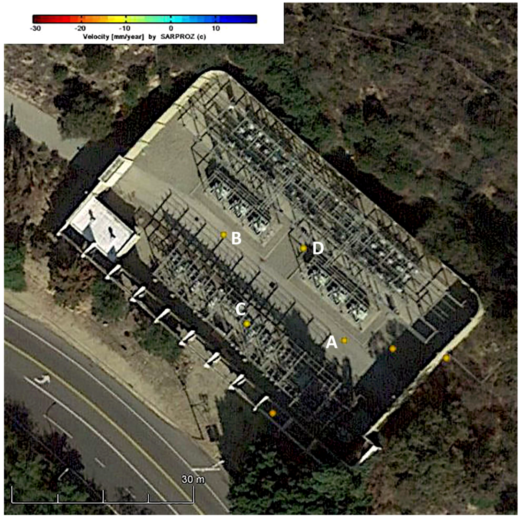
| Point | Temporal Coherence | DR (mm/yr) | Length (m) | ASI | Max ASI |
|---|---|---|---|---|---|
| A | 0.99 | −14.6 | LAB = 53.4 | ||
| B | 0.99 | −14.1 | |||
| C | 0.99 | −13.1 | LCD = 31.2 | ||
| D | 0.99 | −14.1 |
© 2019 by the authors. Licensee MDPI, Basel, Switzerland. This article is an open access article distributed under the terms and conditions of the Creative Commons Attribution (CC BY) license (http://creativecommons.org/licenses/by/4.0/).
Share and Cite
Khorrami, M.; Alizadeh, B.; Ghasemi Tousi, E.; Shakerian, M.; Maghsoudi, Y.; Rahgozar, P. How Groundwater Level Fluctuations and Geotechnical Properties Lead to Asymmetric Subsidence: A PSInSAR Analysis of Land Deformation over a Transit Corridor in the Los Angeles Metropolitan Area. Remote Sens. 2019, 11, 377. https://doi.org/10.3390/rs11040377
Khorrami M, Alizadeh B, Ghasemi Tousi E, Shakerian M, Maghsoudi Y, Rahgozar P. How Groundwater Level Fluctuations and Geotechnical Properties Lead to Asymmetric Subsidence: A PSInSAR Analysis of Land Deformation over a Transit Corridor in the Los Angeles Metropolitan Area. Remote Sensing. 2019; 11(4):377. https://doi.org/10.3390/rs11040377
Chicago/Turabian StyleKhorrami, Mohammad, Babak Alizadeh, Erfan Ghasemi Tousi, Mahyar Shakerian, Yasser Maghsoudi, and Peyman Rahgozar. 2019. "How Groundwater Level Fluctuations and Geotechnical Properties Lead to Asymmetric Subsidence: A PSInSAR Analysis of Land Deformation over a Transit Corridor in the Los Angeles Metropolitan Area" Remote Sensing 11, no. 4: 377. https://doi.org/10.3390/rs11040377