Article

County-Rural Transformation Development from Viewpoint of “Population-Land-Industry” in Beijing-Tianjin-Hebei Region under the Background of Rapid Urbanization

1
Faculty of Geographical Science, Beijing Normal University, Beijing 100875, China
2
Institute of Geographic Sciences and Natural Resources Research, CAS, Beijing 100101, China
*
Author to whom correspondence should be addressed.
Sustainability 2017, 9(9), 1637; https://doi.org/10.3390/su9091637
Submission received: 24 July 2017 / Revised: 31 August 2017 / Accepted: 5 September 2017 / Published: 19 September 2017
(This article belongs to the Special Issue Sustainable Smart Cities and Smart Villages Research)

Abstract

:
In recent years, rural transformation has gradually become the focus of scholars and governments in the context of global sustainable development; it is of great significance to achieve urban-rural integration and coordinated development through studying the spatial-temporal characteristics and driving mechanism of rural transformation development. This paper analyzes the spatial-temporal characteristics of county-rural transformation development through drawing into the transformation degree (TD) and coordination degree (CD) from the viewpoint of “population–land–industry” (PT-IT-LT) in the Beijing-Tianjin-Hebei region. It explores the mechanism of PT-IT-LT on the rural transformation in different stages through multi-element positioning in the same space coordinate system and carries out functional regionalization on the basis of transformation and coordination research. The results showed that: (1) The CD and TD were divided into four types, namely, the lower-level, low-level, middle-level and high-level, and had a similar changed tendency from 1990 to 2015, where the middle- and high-level were in the central counties of the Beijing-Tianjin-Hebei region and the lower- and low-level were in the other parts of the region. (2) According to the mechanism analysis, stages A and B were mainly influenced by industry transformation; stage D was affected by population transformation; and stage E was influenced by land transformation. (3) The Beijing-Tianjin-Hebei region was divided into an ecological conservation area, a key development area and a core leading area, according to the study, which would provide a scientific basis to achieve integration of the Beijing-Tianjin-Hebei region and regional strategic optimization.

1. Introduction

Since reform and opening up, China has experienced a rapid urbanization process with rapid socioeconomic development. Great changes have also taken place in the countryside at the same time, including changes to the peasant living standard and rural living environment [1,2,3]. Rural transformation has been the main form of rural development driven by rapid industrialization and urbanization, and the government has taken many reforms and policies to promote rural economic development and improve the infrastructure [4,5]. The rural transformation has included the spatial organization structure of villages and towns, developmental patterns of rural industry, employment ways, consumption structure, land-use patterns and urban–rural relations [6,7,8]. Thus, rural transformation is an important link to promote urban and rural integration in the process of rapid urbanization.
However, there are many problems during the process of rural transformation, including weakening farmers, environmental pollution, village hollowing and the occupation of cultivated land in China [9,10,11]. To pursue higher wages and better employment opportunities offered by cities, young rural laborers have moved to work in the cities, leaving the aged at home in agriculture roles, or whole families have moved to the cities, leaving empty houses in the countryside. With the development of industrialization, a large number of polluting substances have also been discharged into the village, which has brought about serious impacts on the rural environment [12]. The uncoordinated phenomenon in rural development has become increasingly obvious. Thus, coordination has been an important part of the rural transformation and an important criterion to measure whether rural development has been sustainable or not. Meanwhile the research of rural transformation and coordination development has gradually attracted the attention of scholars over recent years [13,14].
The study of rural transformation has mainly focused on the population, land and industry, and it has had a great deal of research to analyze the coordination of rural development [7,13,15,16], but the question of how to explain the development of rural transformation systematically and comprehensively and how to explore the mechanism of “population-land-industry” (PT-IT-LT)—which consists of three factors, population, land and industry—scientifically has still been difficult. To solve these problems, this paper puts forward the coordination degree (CD) and TD, and combines them with PT-IT-LT in the same space coordinate system in different stages. The TD refers to the transition scale of the rural population, land and industry to the non-agricultural factors and the CD refers to the coordination and conformity of the population, land and industry to the non-agricultural transformation. Then this paper discusses the mechanism of PT-IT-LT on rural transformation in depth, and carries out the functional regionalization to rural development innovatively on the basis of a mechanism analysis and the spatial–temporal characteristics of transitional development in the Beijing-Tianjin-Hebei region. The study is significant for the rural sustainable development and the integration of the Beijing-Tianjin-Hebei region in the future, and it provides method references for the study of rural development.

2. Methods and Materials
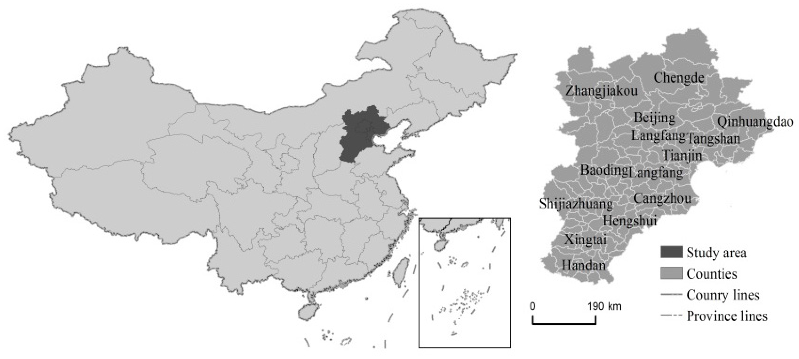
2.1. Study Area

The Beijing-Tianjin-Hebei region is the “capital circle” in China, which includes 13 cities and 200 counties (Figure 1). It is one of the most developed and prosperous regions and attracts worldwide attention. By the end of 2015, the total population of the Beijing-Tianjin-Hebei region was 111 million, and the urban population was 69.7 million; its urbanization rate was 62.5%. The gross domestic product (GDP) was about $1 trillion and the per capita GDP had already exceeded $9000 in 2015. Ever more rural people were attracted to work in the city as a result of the socioeconomic development, and the urban and industrial extension led the rural economy surrounding the city to develop rapidly. More farmers abandoned traditional agriculture and turned to modern agriculture for higher earnings; great changes have taken place in the rural areas of the Beijing-Tianjin-Hebei region over the past 30 years. Thus, the region was a typical case area to study rural transformation over the past 20 years.

2.2. Data and Methods

The urban-rural system is made up of the population, land and industry. The population is the main body of the system, whose behavior can change the system by using other factors. Land is the carrier of the system, which can supply the living and working space for the population and guarantee industrial development. Industry is the power supply of the system, which can improve the living standard of the population and promote the system to rise to a higher level [17,18]. Thus, the population, land and industry are the essential factors of rural transformation [7,13]. These factors are interactive with each other in the process of transformation, and their coordination relationship has promoted the development of the urban-rural system. With socioeconomic development, the second industry and the tertiary industry have expanded their scale continuously; ever more of the rural population has been attracted to the city for its high living standard, which has accelerated the process of urbanization in recent years and increased the demand for living-space land [3,14]. Meanwhile, the external population has made a great contribution to the urban economy and expanded the scale of cities. The population, land and industry have been interactive with each other to form a development cycle system. Therefore, studying the rural PT-IT-LT has aided the understanding of the developing law of the rural system and has been of great significance to promote the coordinated development of urban and rural areas.
Population, land and industry are regarded as important factors in the process of rural transformation. Population transformation refers to farmers moving into towns to engage in non-agricultural employment or to live; land transformation refers to farmland becoming construction land; industry transformation refers to agriculture turning into the second and tertiary industries, which produces rural development. Thus, this study uses these three indicators to analyze the rural transformation degree (TD). This includes the proportion of agricultural labor with non-agricultural employment accounting for the total agricultural labor (PT) and the proportion of non-agricultural output value accounting for the GDP (IT), which came from the statistical yearbook of Beijing, Tianjin and Hebei [19,20,21], and the proportion of urban-industrial and mining land accounting for the total land area (LT), which was provided by the Resource and Environment Science Data Center of Chinese Academy of Sciences (http://www.resdc.cn) [22,23,24]. Two important indicators, the CD and TD, have been defined to describe the development of the rural transformation in the county.
All data had to be dimensionless to control the indicator value, which was from 0 to 1, allowing it to be calculated easily, and the indicators were given weights by mean deviation (Table 1). The CD with three indicators was acquired by Equation (1), which was improved by the formula for coupling coordination [25]; the formula aimed to test the consistency of change in PT-IT-LT, and its value was between 0 and 1. The closer to 1 the value was, the better the coordination relationship of the three indicators. The TD was obtained by adding three indicators with different weights (Equation (2)) [23,26]. The counties in the Beijing-Tianjin-Hebei region were seen as sample points to study the characteristics of rural transformation development by cluster analysis. The cluster analysis regarded the TD as basic ordered data, and added the CD and PT-IT-LT to the unified coordinate system; then the study divided the transformation development types according to the variation trend of the TD, CD and PT-IT-LT; in the last, the study named the transformation development types by multidimensional elements: “population-land-industry” + “coordination degree” + “transformation degree”.
CD = PT × IT × LT ( PT + IT + LT 3 ) 3
TD = α × PT + β × IT + γ × LT

3. Results

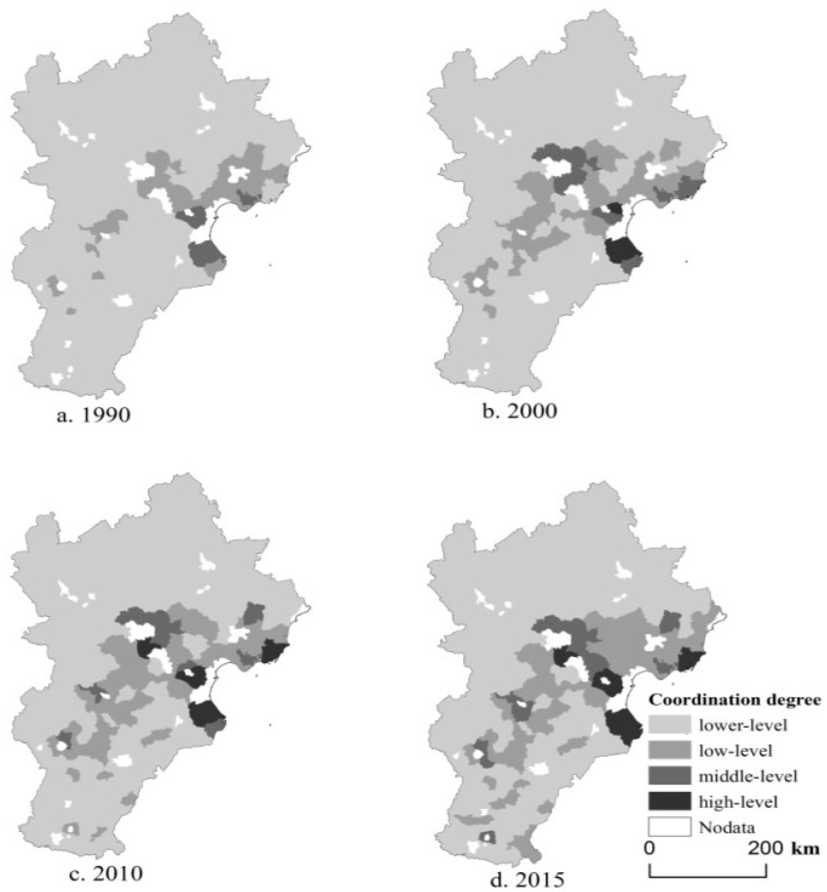
3.1. Coordination Degree

The study used the improved Equation (1) to obtain the CD of the PT-IT-LT (Figure 2). It used the quartering method to analyze the result in different periods: the first stage was the lower-level coordinate whose degree was from 0.0 to 0.25; the second stage was the low-level coordinate whose degree was from 0.25 to 0.50; the third stage was the middle-level coordinate whose degree was from 0.50 to 0.75; the last stage was the high-level coordinate whose degree was from 0.75 to 1.0.
In time, the CD of the PT-IT-LT changed to high-level from low-level, and the mean value of the CD was 0.14, 0.20, 0.26 and 0.28 from 1990 to 2015. From 1990 to 2015, the CD was generally lower-level, but the proportions accounting for the total counties decreased gradually, and the values were 83.44%, 70.70%, 61.78% and 56.69%. The proportions of the low-level, middle-level and high-level CD accounting for the total counties increased from 1990 to 2015, which showed that the CD of rural PT-IT-LT in the Beijing-Tianjin-Hebei region continuously improved. With the economic development, ever more farmers gave up agriculture and left rural areas to work in factories; the demand for land increased, and the government had to take measures to alleviate the conflict between population and land.
In terms of space, most counties belonged to the lower-level CD from 1990 to 2015, but they had great spatial differences. The high-level CD of PT-IT-LT applied to Beijing and Tianjin; few counties occurred in the center of the Beijing-Tianjin-Hebei region (Figure 3). A circle structure from southeast to northwest Beijing-Tianjin-Hebei was clear; the CD of coastal counties was greater than for those far from the sea, which reflected the order of socioeconomic development in the region. The CD of some southeastern counties had reached the middle-level in 2015, while the northwestern counties were still at the lower-level, compared with 1990, because the economic development in the southeast with more advantages was faster than for the northwest, and its economy promoted the rural areas to develop in a more coordinated manner.

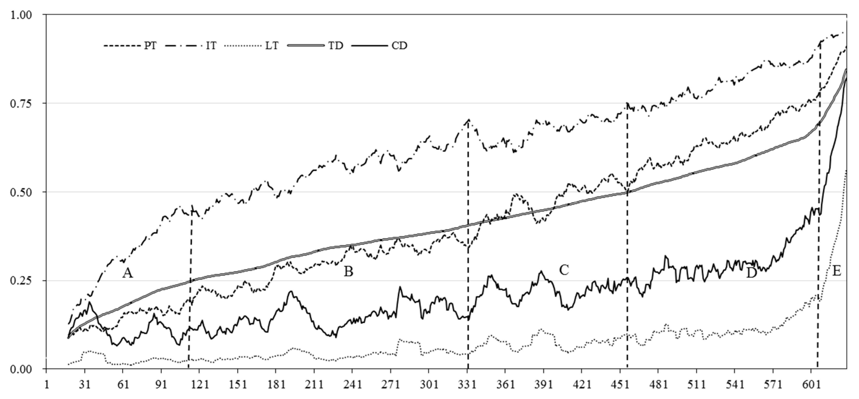
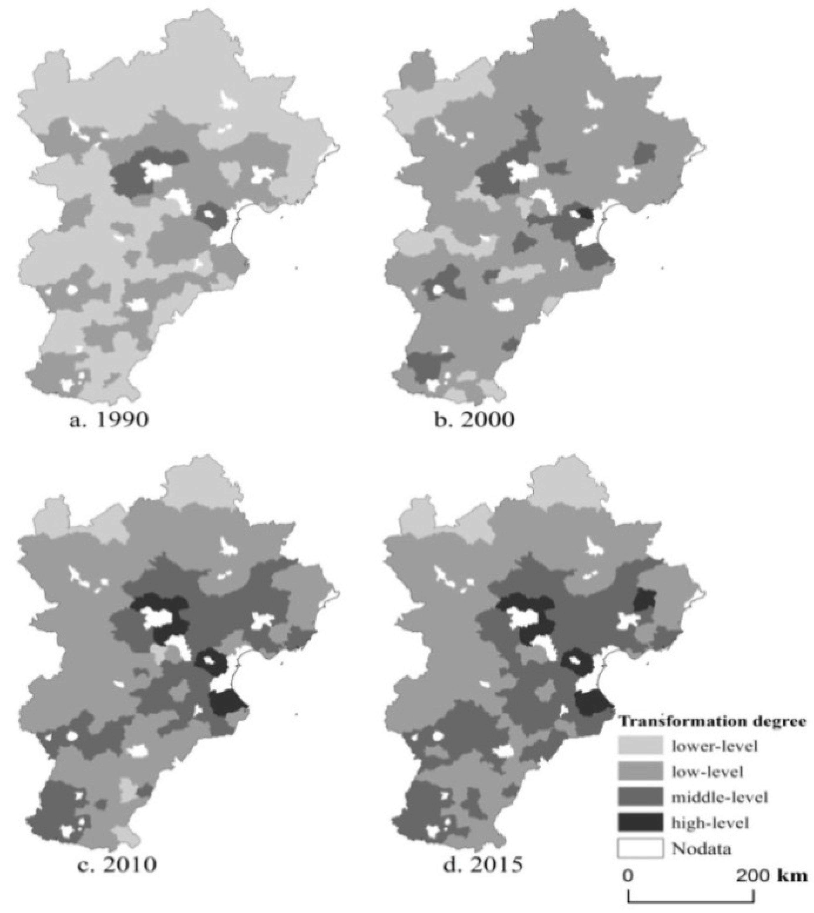
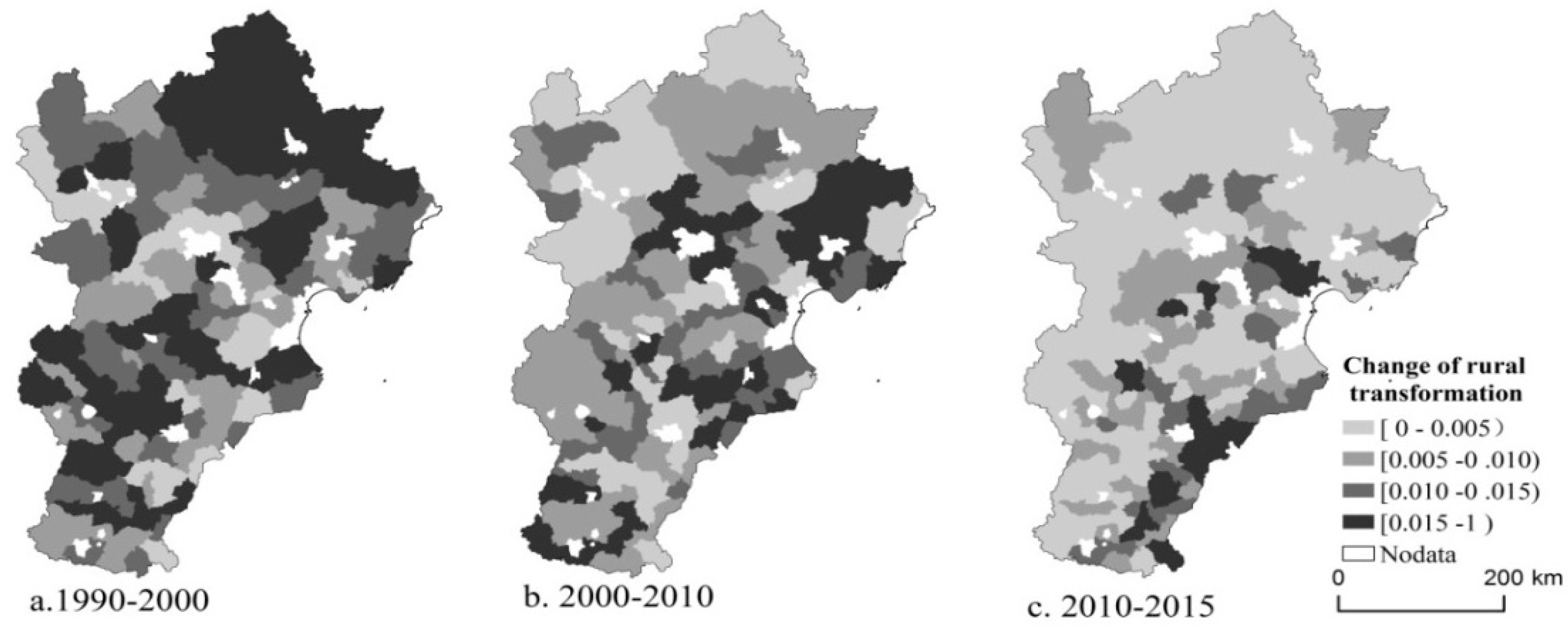
3.2. Transformation Degree

The study obtained the rural TD of different counties by the linear weighting of three indicators from 1990 to 2015. According to the value of the TD, the study divided rural transformation into four types: lower-level transformation (0–0.25), low-level transformation (0.25–0.50), middle-level transformation (0.50–0.75), and high-level transformation (0.75–1.0). From Figure 4, no counties in the region achieved the high-level transformation, and most of the counties remained at the lower-level transformation (52.86%) in 1990. The proportion of high-level transformations increased, and the proportion of lower-level transformations decreased from 1990 to 2015; there were 10 counties with high-level transformation in 2015, while the number with lower-level transformation was only 3, accounting for 1.91% of the total counties. The result reflected that the level of the TD in the Beijing-Tianjin-Hebei region gradually became better from 1990 to 2015, and there was a great difference in these counties because of their different bases in different periods.
In terms of space, there was a spatial development trend similar to that of the CD from 1990 to 2015. Beijing and Tianjin were the cores of this region, and the TD of their counties was always higher than for other counties, reaching high-level transformation in 2015 (Figure 4). However, the northwestern area of the Beijing–Tianjin–Hebei region was at the lower-level from 1990 to 2015. This shows that regional differences were a serious problem that hindered the development of urban and rural integration.
To analyze the differences in the TD, this study obtained the speed of transformation for the periods of 1990–2000, 2000–2010 and 2010–2015 (Figure 5). The speed for 1990–2000 was higher than that for 2000–2010 and 2010–2015, and the speed for 1990–2000 and 2000–2010 did not follow an obvious trend, but the speed for 2010–2015 in the southeast of the Beijing-Tianjin-Hebei region was faster than for other regions. However, the speed decreased gradually from 1990 to 2015, and its change trend was opposite to that of the TD. Thus, the higher the transformation level was, the lower its speed.

3.3. Rural Transformation—Coordination Development

The study obtained the fitting curves of the PT-IT-LT, CT and TD by disturbance translation with 18 iterations, which avoided the volatility of the sample counties’ data. Then, according to the coupling results of all the factors, the rural transformation–coordination development was divided into five types: fast industry lower-level coordination and transformation development (A), fast industry and population lower-level coordination and low-level transformation development (B), high factors lower-level coordination and low-level transformation development (C), fast population low-level coordination and middle-level transformation development (D) and fast land middle- and high-level coordination and transformation development (E) (Figure 6).
(1) The fast industry lower-level coordination and transformation development (A) described the industry transformation increasing continuously with rapid growth and was higher than the population and land transformation. The CD and land transformation had lower-level stability, and the TD was lower-level but increased slowly. This reflected that the industry transformation had an influence on the rural TD but had no effect on the rural CD.
(2) The fast industry and population lower-level coordination and low-level transformation development (B) described the industry and population transformation growing quickly, but the land transformation and CD increasing very slowly. The TD was low-level and improved with the change of industry and population transformation. Thus, this showed that the industry and population had a larger impact on the rural TD than the land but a smaller function for the rural CD.
(3) The high factors lower-level coordination and low-level transformation development (C) was a type for which the population, industry and land were relatively stable and without significant change. However, the coordination was still lower-level and it had a high volatility similar to the change of the land transformation. It is clear that the land transformation was promoting the change of the rural CD, and the rural TD was affected by population, land and industry together in these counties.
(4) The fast population low-level coordination and middle-level transformation development (D) showed that the TD was middle-level and increased rapidly with the change of population. Meanwhile, the CD had reached the lower-level and its growth was slower than that of the TD. The amplitude for the land transformation and industry was also lesser than that of the population transformation. Thus, the population was the main factor influencing the rural transformation in the regions.
(5) The fast land middle- and high-level coordination and transformation development (E) was the most highly developed type, whose TD and CD were middle- or high-level and whose population transformation and industry transformation were also high-level in these regions. However, the increase of land transformation was more than other types and arrived at the high-level, as for the population and industry in the previous sample points. Accordingly, land was the most important factor for the rural transformation in these counties.
According to the characteristics of different rural transformation types, we found the developing state of different counties from 1990 to 2015, and detected the leading factors influencing the TD and CD, which would provide support for the functional subzones of the rural transformation development in the Beijing-Tianjin-Hebei region and greatly enlighten the study of rural development.

4. Discussions

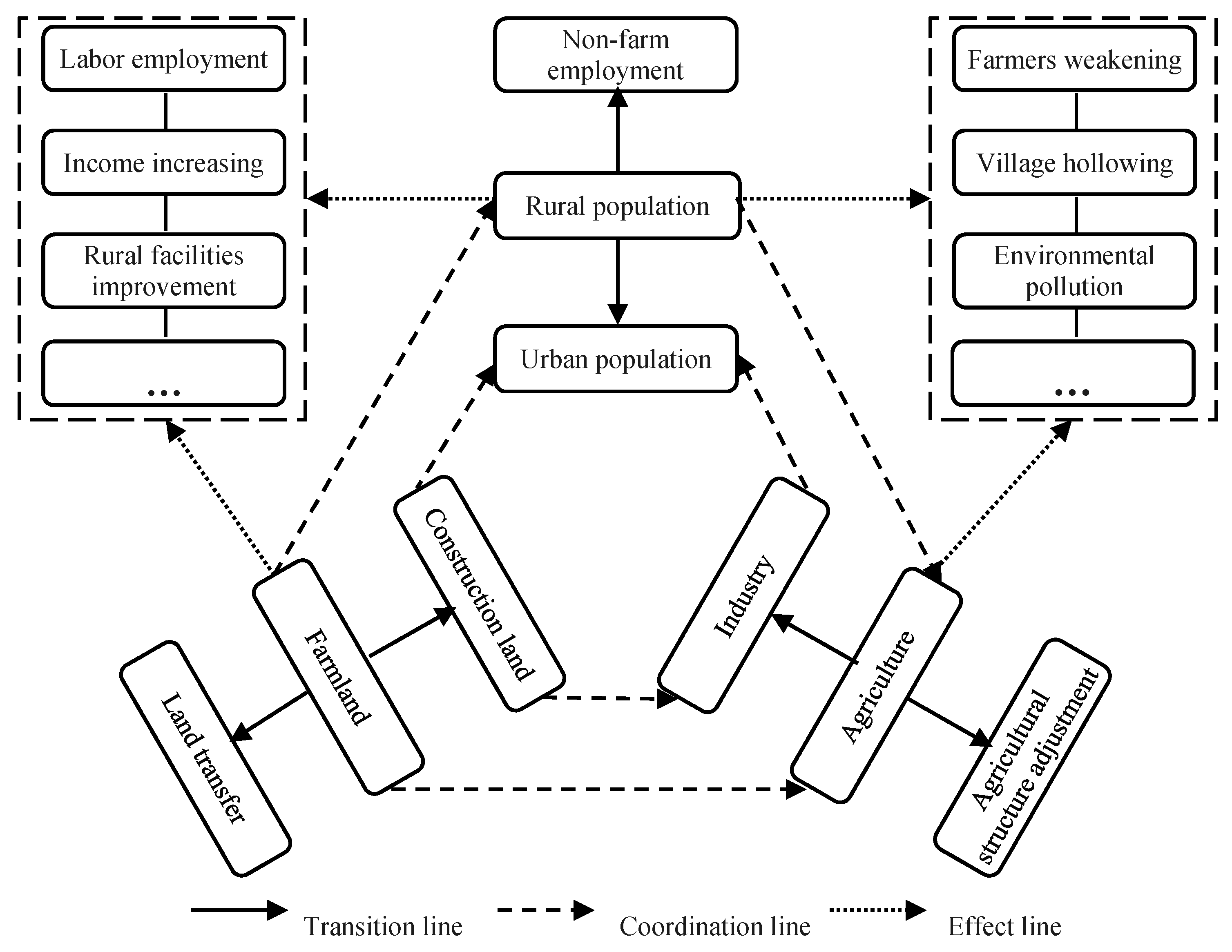
4.1. Mechanism of Population–Land–Industry to Rural Transformation

This paper uses the CD and TD to describe the spatial and temporal characteristics of rural transformation development from the view of PT-IT-LT in Beijing-Tianjin-Hebei. It shows the difference among these counties from 1990 to 2015. The rural transformation development has been divided five types by cluster analysis and multidimensional element naming, which revealed the development characteristics of different counties easily because of the different influences of population, land and industry. Thus, it was very necessary to further analyze the mechanism of PT-IT-LT on the rural transformation development (Figure 7). The study has important value for achieving urban and rural integration and coordinated development of the Beijing-Tianjin-Hebei region in the future.
The population mainly refers to the rural population, which is subject to the rural system. These people live in the countryside with their own land and have engaged in agriculture for a long period of time. With the social development, cities have appeared gradually and their economies have boomed rapidly. Many in the rural population have been attracted to the cities for a high quality of life. However, the cities have continued to expand at a higher speed in modern times, and more from the agricultural population have moved into cities and become part of the urban population. There have also been many surplus rural labors becoming migrant workers for a higher income without farming, and the living standard of the rural population has gradually improved. The rural population migration and non-agricultural employment has been better for relieving the employment pressure of surplus rural labors; it has had important effects as shown in the rural transformation development in Figure 6 (D). However, there have been lots of problems, such as agriculture subject weakening and village hollowing, in the Beijing-Tianjin-Hebei region.
Land is the material base for human living and is the object of the rural system. Rural transformation has mainly been the change between farmland and construction land, which were the important forms bearing human production and life, but the two were usually antagonistic. The expansion of urban environments has required lots of construction land, which often occupied large areas of farmland before the farmland protection was formulated. Now, the land transfer has become popular in villages; the rural labor has been outflowing, especially in the developed areas. The land transformation has had a great influence on rural development with the rise of land prices, as shown in Figure 6 (E); the high-speed growth of land transformation has promoted the rural transformation and coordination to reach high-level. The quality of farmland has decreased, although the quantity of farmland has been protected without preventing urban sprawl, and the adjustment of production structure as a result of land transfer may also threaten food safety in the future.
Industry is a necessary link between population and land, and it provides a guarantee for social development. In the early stages of human society, agriculture was the only industry, but cities boomed little by little with the development of secondary industries and tertiary industries. The development of industry was the main cause of population migration and land transfer. Thus, the study selected non-agricultural industry for rural industry transformation. The industry greatly improved the living standard of farmers, and eliminated the rural poverty and back-warded to form new countryside, as shown in Figure 6 (A and B). However, the secondary industry brought lots of pollution to the village; the rural environment was damaged and more serious illnesses occurred in recent years than in the early years because of the soil and water pollution.
Through an analysis of the effect of population, land and industry on the rural transformation, the study found that there were also many problems in the process of factor transformation as a result of no coordination among these three factors. Thus, in the study of transformation development, coordination must be considered. The study used a quartering method to obtain a different level of the CD and TD, which was lower than for other studies. However, this made the mechanism of PT-IT-LT on rural transformation development clear to analyze; it was more scientific to divide the types of rural transition development and diagnose the problems of regional differences.
However, an important factor was policy influencing on the rural transformation development in China. The policy had a guiding function to the rural development and promoted transformation of the PT-IT-LT, such as new countryside construction and modern agriculture development, which formed typical villages as the pilot to build new rural communities and form many famous rural brand industries in China. This paper mainly analyzed the rural transformation development from the perspective of PT-IT-LT; it did not describe rural development policies in detail. However, policy was essential for rural development, and further research is needed in the future.

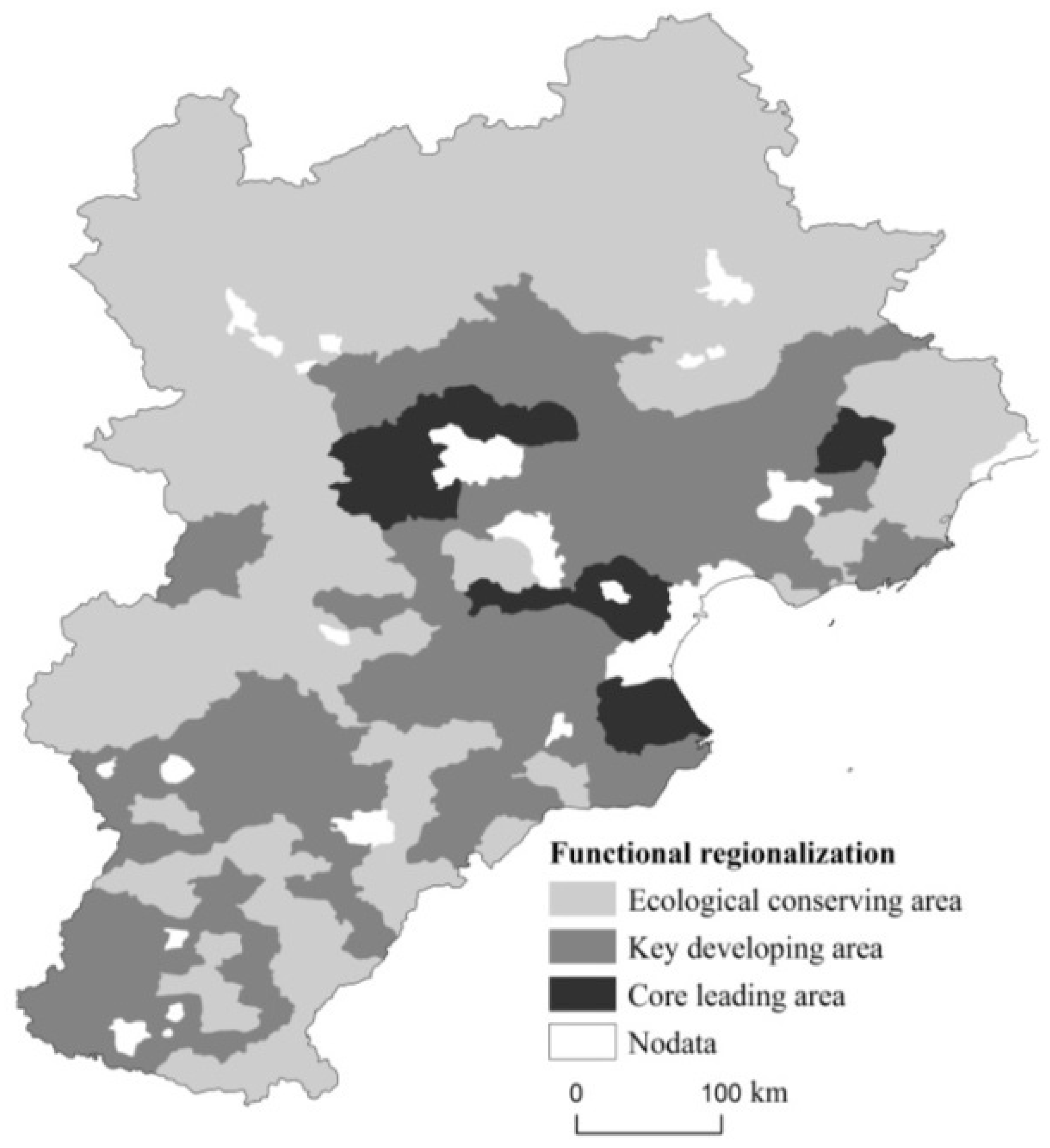
4.2. Functional Regionalization of Rural Transformation Development

According to the results of discussions on the relationship between the TD and CD, the counties in the Beijing-Tianjin-Hebei region were divided into five types. The study gave each type a different score: “A” was 1, “B” was 2, “C” was 3, “D” was 4 and “E” was 5; then, each county acquired a score for its rural transformation–coordination development from 1990 to 2015. The study developed the county-rural transformation by dividing the functional regionalization by the mean score of the transformation–coordination development, which included the ecological conservation area, key development area and core leading area (Figure 8).
The core leading areas were mainly located in the center of the Beijing-Tianjin-Hebei region, and belonged to the counties of Beijing and Tianjin; these included 11 counties. The region was one of the most densely populated areas and was the political and economic center in China. The rural TD and CD were middle- and high-level, and their rural area reached the higher development level with high urbanization and industrialization. Thus, the land transformation was the major leading factor to promote village development, but land price in the region was much higher than for other regions, which was a resistance for the rural development of the future. However, the rural development had been at a high level in the region; it should keep the development state and lead other regions to form sustainable and scientific rural development as the guidance core.
The key developing areas included 79 counties accounting for 50% of the total, laying to the south and central parts of Beijing-Tianjin-Hebei. These regions’ TD and CD were middle- and low-level, and their rural development was still lower than that of the core leading area. However, the region had large development drivers, including the population and industry. With the socioeconomic development, many heavy factories in Beijing or Tianjin moved to the counties in Hebei, which improved the local economic development and promoted more of the rural population to work at the factory. Meanwhile, the rural population of the counties around Beijing, Tianjin and Shijiazhuang was attracted to the urban areas for high earnings; some people became part of the urban population and some worked in the city for a long period of time. Thus, the driving factors in the region were the population and industry transformation. However, there were some serious problems with the rural transformation development in the region, such as farmers weakening, environmental pollution and village hollowing in recent years, because the CD of the population, land and industry was lesser than for Beijing and Tianjin. However, the region should continue to develop and build the new sustainable rural areas, whilst also considering the factors in the process of rural development.
The ecological conservation area was in the north and west of the Beijing-Tianjin-Hebei region and included 67 counties, whose TD and CD were low- and lower-level. These counties were also near Beijing and Tianjin, but their rural development was worse than that of the core leading area and the key developing area because of their poor natural conditions. The population was also attracted to Beijing and Tianjin without local industry support, which formed the “siphon effect”, and many poor counties and poor villages appeared around Beijing. Thus, the rural development in the region clearly lagged behind other areas. However, there were also rich natural eco-tourism resources and cultural deposits; the industry transformation promoted rural development in the region for tourism and leisure services, but far away from environmental pollution. Thus, the region had great development potential and needed to wait for the help of the key developing area and core leading area. Now it should uptake the task of environmental protection in the Beijing-Tianjin-Hebei region as an ecological conservation area.

5. Conclusions

This paper analyzed the county-rural transformation development in the Beijing-Tianjin-Hebei region from 1990 to 2015 from the perspective of PT-IT-LT, and obtained the TD and CD using a coupling method with multi-indicators. The rural transformation—coordination development was divided into five types and the functional areas were divided into three types, including the ecological conservation area, key development area and core leading area, which provided reference and research methods for the coordinated and sustainable development in Beijing-Tianjin-Hebei.
(1) The CD and TD were divided into four types: lower-level (0–0.25), low-level (0.25–0.5), middle-level (0.5–0.75) and high-level (0.75–1.0). These had similar changing tendencies from 1990 to 2015. Middle- or high-level counties were located in the central area of the Beijing-Tianjin-Hebei region, and lower- or low-level counties were located in the other regions. There were a large number of differences among the counties because of the influence of the population, land and industry.
(2) The rural transformation—coordination development was divided into five stages: fast industry lower-level coordination and transformation development (A), fast industry and population lower-level coordination and low-level transformation development (B), high factors lower-level coordination and low-level transformation development (C), fast population low-level coordination and middle-level transformation development (D) and fast land middle- and high-level coordination and transformation development (E). Each stage had its own characteristic. The results showed that according to the mechanism analysis of PT-IT-LT to rural transformation, stages A and B were mainly influenced by industry transformation, stage D was affected by population transformation, and stage E was impacted by land transformation.
(3) The study carried out functional regionalization of rural transformation development in the Beijing-Tianjin-Hebei region on the basis of coupling of the CD and TD and the mechanism of PT-IT-LT. The functional areas were segmented into three areas, which were the ecological conservation area, the key development area and the core leading area. The core leading area included 11 counties, which were already of high-level rural development; the key development area included 79 counties, whose priority needed to be given to rural development; the ecological conservation area consisted of 67 counties, which should promote rural development in the region for tourism and leisure services. The functional regionalization of rural development could provide a scientific basis to achieve the integration of the Beijing-Tianjin-Hebei region and regional strategic optimization.

Acknowledgments

This research was funded by the grants from the Major Project of National Social Science Found of China (15ZDA021), National Natural Science Foundation of China (41130748, 41471143) and China Postdoctoral Science Foundation (2016M600954).

Author Contributions

As the lead author, Jintao Li initiated this study with an original idea, conducted the overall analysis and wrote this article. Yuanyuan Yang, as a corresponding author suggested appropriate methodologies for the overall analysis. Ning Jiang provided help for data collection. All authors have conducted the data processing and other related work.

Conflicts of Interest

The authors declare no conflict of interest.

References

  1. Nyberg, A.; Rozelle, S. Accelerating China’s rural transformation. In Accelerating Chinas Rural Transformation; World Bank Publications: Washington, DC, USA, 1999; pp. 13–18. [Google Scholar]
  2. Long, C.Y. The Mechanisms of Cropland Conservation in Chinese Rural Transformation. Sci. Geogr. Sin. 2001, 187, 91–103. [Google Scholar]
  3. Keith, B. From proletarian to peasant: Rural transformation in the state of Acre, 1870–1986. J. Dev. Stud. 2007, 24, 141–160. [Google Scholar]
  4. Abam, F. Developing the Biofuel Industry for Effective Rural Transformation in Nigeria. Eur. J. Sci. Res. 2010, 40, 441–449. [Google Scholar]
  5. Desai, S.; Vashishtha, P.; Joshi, O. Mahatma Gandhi National Rural Employment Guarantee Act: A Catalyst for Rural Transformation; National Council of Applied Economic Research: New Delhi, India, 2015. [Google Scholar]
  6. Julie, C. Concentration and decentralization: The new geography of freight distribution in US metropolitan areas. J. Transp. Geogr. 2010, 18, 363–371. [Google Scholar]
  7. Li, T.T.; Long, H.L. Rural development from viewpoints of transformation and coordination: A case in Shandong Province. Prog. Geogr. 2014, 33, 531–541. [Google Scholar]
  8. Liu, Y.S.; Yang, R. The spatial pattern measure of urban-rural development transformation in the Bohai Rim region in China. Acta Geogr. Sin. 2015, 70, 248–256. [Google Scholar]
  9. Long, H.L. Land use transition and rural transformation development. Prog. Geogr. 2012, 31, 131–138. [Google Scholar]
  10. Li, F.R.; Wang, Y.S.; Hu, Y.L.; Yao, X. Research on Yancheng Coastal Beach Reclamation Development and Ecological Environment Protection. J. Green Sci. Technol. 2013, 9, 155–157. [Google Scholar]
  11. Liu, Y.S. Integrated land research and land resources engineering. Resour. Sci. 2015, 37, 1–8. [Google Scholar]
  12. Reddy, A.A.; Rani, C.R.; Cadman, T.; Reddy, T.P.; Battarai, M.; Reddy, A.N. Rural Transformation of a Village in Telangana, a Study of Dokur since 1970s. Int. J. Rural Manag. 2016, 12, 143–178. [Google Scholar] [CrossRef]
  13. Yang, R.; Liu, Y.S.; Long, H.L. The study on non-agricultural transformation co-evolution characteristics of “population-land-industry”: Case study of the Bohai Rim in China. Geogr. Res. 2015, 49, 972–975. [Google Scholar]
  14. Liu, Y.S.; Long, H.L.; Chen, Y.F.; Wang, J.Y.; Li, Y.R.; Li, Y.H.; Yang, Y.Y.; Zhou, Y. Progress of research on urban-rural transformation and rural development in China in the past decade and future prospects. J. Geogr. Sci. 2016, 26, 1117–1132. [Google Scholar] [CrossRef]
  15. Fichera, C.R.; Modica, G.; Pollino, M. GIS and Remote Sensing to Study Urban-Rural Transformation during a Fifty-Year Period. In Proceedings of the International Conference on Computational Science and its Applications, Santander, Spain, 20–23 June 2011; Springer: Berlin, Germany, 2011; pp. 237–252. [Google Scholar]
  16. Hu, Z.C.; Wang, Y.L.; Liu, Y.S.; Long, H.L.; Peng, J. Spatio-Temporal Patterns of Urban-Rural Development and Transformation in East of the “Hu Huanyong Line”, China. ISPRS Int. J. Geo-Inf. 2016, 5, 24. [Google Scholar] [CrossRef]
  17. Gibson, C. Rural Transformation and Cultural Industries: Popular Music on the New South Wales Far North Coast. Geogr. Res. 2010, 40, 337–356. [Google Scholar] [CrossRef]
  18. Oleti, G. Effects of internal migration on poverty reduction, income and gender inequality, rural transformation (including urbanization of towns) and agricultural productivity. Appl. Geochem. 2017, 38, 82–91. [Google Scholar]
  19. Xia, Q.F. Beijing Statistical Yearbook; Beijing Statistics Bureau: Beijing, China, 1990/2000/2010/2015. [Google Scholar]
  20. Wu, J.D.; Peng, Z.L. Tianjin Statistical Yearbook; Tianjin Statistics Bureau: Tianjin, China, 1990/2000/2010/2015. [Google Scholar]
  21. Wu, X.H.; Meng, X.Y.; Peng, J.Q. Hebei Economic Yearbook; People’s Government of Hebei Province: Shijiazhuang, China, 1990/2000/2010/2015.
  22. Zhou, H.; Wang, B.J. Analysis of the coupling rurality index and rural transformation development of Jiangsu province in China in the early 21st century. China Popul. Resour. Environ. 2013, 23, 48–55. [Google Scholar]
  23. Li, T.T.; Long, H.L. Analysis of rural transformation development from the viewpoint of “population-land-industry”: The case of Shandong Province. Econ. Geogr. 2015, 35, 149–155. [Google Scholar]
  24. Wang, Y.F.; Liu, Y.S.; Li, Y.H. The Spatial Disparity of Rural Transition Development and Regional Characteristics of Its Driving Forces. Econ. Geogr. 2016, 36, 135–142. [Google Scholar]
  25. Liu, Y.B.; Li, R.D.; Song, X.F. Analysis of Coupling Degrees of Urbanization and Ecological Environment in China. J. Nat. Resour. 2005, 20, 105–112. [Google Scholar]
  26. Li, T.T.; Long, H.L. Study on the spatio-temporal pattern of rural transformation development in Shandong province. Geogr. Res. 2014, 33, 490–500. [Google Scholar]
Figure 1. Study area.
Sustainability 09 01637 g001
Figure 2. Coordination degree (CD) from 1990 to 2015.
Sustainability 09 01637 g002
Figure 3. Coordination degree (CD) in Beijing-Tianjin-Hebei region.
Sustainability 09 01637 g003
Figure 4. Rural transformation degree (TD) from 1990 to 2015.
Sustainability 09 01637 g004
Figure 5. Change of transformation degree (TD) from 1990 to 2015.
Sustainability 09 01637 g005
Figure 6. Rural transformation-coordination and population-land-industry (PT-IT-LT).
Sustainability 09 01637 g006
Figure 7. Mechanism of population-land-industry (PT-IT-LT) transformation in Beijing-Tianjin-Hebei.
Sustainability 09 01637 g007
Figure 8. Functional regionalization of rural transformation development in the Beijing-Tianjin-Hebei region.
Sustainability 09 01637 g008
Table 1. Indicators of rural transformation.
Criteria LayerIndex LayerWeights
PopulationThe proportion of agricultural labor with non-agricultural employment accounting for the total agricultural labor.0.387
LandThe proportion of urban-industrial and mining land accounting for the total land area.0.239
IndustryThe proportion of non-agricultural output value accounting for gross domestic product.0.374

