Article

Analyzing the Effects of Spatial Interaction among City Clusters on Urban Growth—Case of Wuhan Urban Agglomeration

1
College of Management and Economics, Tianjin University, No. 92, Weijin Road, Nankai District, Tianjin 300384, China
2
School of Econimics and Management, Tianjin Chengjian University, Jinjing Road, Xiqing District, Tianjin 300072, China
3
School of Resource and Environment Science, Wuhan University, No. 129, Luoyu Road, Hongshan District, Wuhan 430079, China
*
Authors to whom correspondence should be addressed.
Sustainability 2016, 8(8), 759; https://doi.org/10.3390/su8080759
Submission received: 13 July 2016 / Revised: 2 August 2016 / Accepted: 3 August 2016 / Published: 5 August 2016
(This article belongs to the Section Sustainable Urban and Rural Development)

Abstract

:
For the past two decades, China’s urbanization has attracted increasing attention from scholars around the world. Numerous insightful studies have attempted to determine the socioeconomic causes of the rapid urban growth in Chinese cities. However, most of these studies regarded each city as a single entity, with few considering inter-city relationships. The present study uses a gravity-based model to measure the spatial interaction among city clusters in the Wuhan urban agglomeration (WUA), which is one of China’s most rapidly urbanizing regions. The effects of spatial interaction on urban growth area were also analyzed. Empirical results indicate that, similar to urban population or employment in secondary and tertiary industries in the WUA from 2000 to 2005, the spatial interaction among city clusters is one of the main drivers of urban growth. In fact, this study finds the effects of spatial interaction as the only socioeconomic factor that affected the spatial expansion from 2005 to 2010. This finding suggests that population migration and information and commodity flows showed greater influence than the socioeconomic drivers of each city did on promoting urbanization in the WUA during this period. We thus argue that spatial interaction among city clusters should be a consideration in future regional planning.

1. Introduction

Urban clusters have become the basic geographical and organizational units for countries engaging in international competition and cooperation in an increasingly global economy. The same is especially true of China’s urban agglomerations. The rapid increase in urban population and economy, as well as China’s 1976 reform and opening-up policy, has caused significant changes in the spatial extent and structure of Chinese cities. Urban growth has become one of the most apparent geographic phenomena in coastal and central areas, and over the last two decades, some mega-city regions such as the Yangtze River Delta and Pearl River Delta have become comparable to the megalopolises common to North America and Northern Europe. According to Fang et al. (2005) in 2012, 28 urban agglomerations in China, despite covering only 21.98% of the country’s territory, made up 44.36% of the total population and accounted for more than half of the economic and industrial productivity [1]. These mega-city regions also provided the vast majority of the country’s financial revenue, thus attracting over 90% of the foreign investments. Although some developed European countries, Japan, and the USA witnessed an urban shrinkage trend during this time [2], the urbanization process, characterized by a large proportion of the rural population migrating into cities, coupled with an unprecedented scale and rate of urban expansion, is expected to continue in developing countries. A comprehensive review of the implications of urban growth conducted by Bhatta et al. (2010) indicated that the encroachment on natural and semi-natural surfaces has fundamental and multi-dimensional implications for socioeconomic, environmental, and natural aspects worldwide [3]. Some of the urban agglomerations in China have revealed problems in their growth processes, including the “four shortages” (low development degree, low compactness, low input–output efficiency, and low level supply of resources) and the “four surpluses” (excessive administrative intervention, high expectation of development prospect, high negative effects of high density gathering, and high development disparities) [4]. In this context, social scientists and policy makers have attempted to understand the underlying driving forces of urban expansion to build models for estimating land use evolution and designing sustainable land use policies.
Many of the previous studies identified the driving forces or determinants of urban growth as mainly physical, socioeconomic, and neighborhood factors. Topography, slope and elevation are the important physical factors of urban growth [5,6]. The elevated areas were usually developed in the early stage of urban development as they cannot be invaded by floods [6]. Slope and elevation showed constantly negative effects on urban growth of Beijing city from 1972 to 2010, and their effects decreased with the urbanization process because of the shortage of urban land, the advancement of technology, and the affordability of high development costs in mountain areas [7,8]. Compared with physical factors, a great number of papers have reported that urban population, economic growth, and industrialization have a positive and significant influence on urban growth [6,8,9,10,11,12]. Urban land use change is apparent in the urban fringe in China as there is heavy demand on residential land to accommodate the increasing population [10,13]. Also, urban population growth would result in the increase of demand of traffic and public infrastructure land [5,14]. With the economic growth, both government and enterprises can expand their investments in urban construction which leads to increased demand for urban land [10,14]. The agricultural productivity can also be improved with the economic growth as more agricultural land is used in urban construction, and the expansion of consumption capacity of urban residents with the economic growth can stimulate urban land demand indirectly [11]. In addition, industrialization is another factor of urban growth in China. With the development of industrialization, the ratio of secondary and tertiary industries was increased, which also boosted the demand for urban land in China. Over the past years, the newly emerging intensive economic development zones caused by industrialization have triggered dramatic land use change in many Chinese cities [15,16]. Apart from these socioeconomic factors, some scholars argue that spatial determinants such as distance to urban centers, distance to roads, distance to CBD, etc., play great roles in urban growth [17,18,19,20,21,22]. Theoretically, the closer to the important geographical locations (city center, central business district, metro station, etc.) the higher possibility for the development of non-urban land will be.
Although these studies have showed insightful findings and made great contribution to the literature, they often focused on one or multiple factors related to a single city, with few taking into account the effects of spatial interaction among city clusters on urban growth. Spatial interaction associated with rural–urban migration, information, capital, and commodity flows among cities across space in a city cluster affects the growth and spatial patterns of hierarchical cities. At the same time, the growth of these cities gives feedback to spatial interactions. Spatial interaction essentially causes isolated cities to spatially integrate with one another with particular functions and structures. With the spatial interaction increasing, the urban flow intensity, which is the symbol of the strength of the influence from the centralization of the cities, will increase and the collection among cities will be enhanced. These invisible forces often play great roles in shaping urban forms and driving the regional development of urban agglomerations [23]. Therefore, we expect that spatial interaction among cities will have a positive influence on urban growth. In the field of urban geography, geographers often use gravity models to describe and measure the spatial interaction of urban flows. Gravity models are based on the theory that the spatial interaction between two cities is proportional to their socioeconomic intensities (such as population size and economic capability) and inversely proportional to the distance between them [24]. Recently, gravity-based models have been proven to be effective in dealing with location-based problem solving [25], spatial access assessment [26,27], and trade and urban flow measurements [28,29]. He et al. (2013) integrated a gravitational field model based on urban flows with a cellular automata model to simulate the urban growth in the Beijing–Tianjin–Tangshan megalopolitan cluster area [28]. Prior to their simulation of future urban growth, the authors hypothesized that the spatial interaction among cities was one of the main driving forces of urban dynamics. Currently, the nature of the spatial interaction among cities and the extent to which it affects the cities’ spatial growth are still unknown.
As the most important economic district and transport hub of central China, Wuhan urban agglomeration (WUA) has undergone rapid economic development and an unprecedented urban sprawl, leading to environmental and ecological issues over the past few years [30,31]. The driving mechanism of urban growth must be analyzed to inform sustainable land use planning and policy. The present study aimed to analyze the effects of the spatial interaction among city clusters on urban growth in the WUA. To accomplish this objective, we first investigated the simultaneous evolution of urban expansion and spatial interaction among cities. We then evaluated this spatial interaction using a gravity-based model and quantified the socioeconomic drivers, including spatial interaction. Finally, we discuss why the spatial interaction among city clusters is responsible for urban growth in the WUA.

2. Materials and Methods
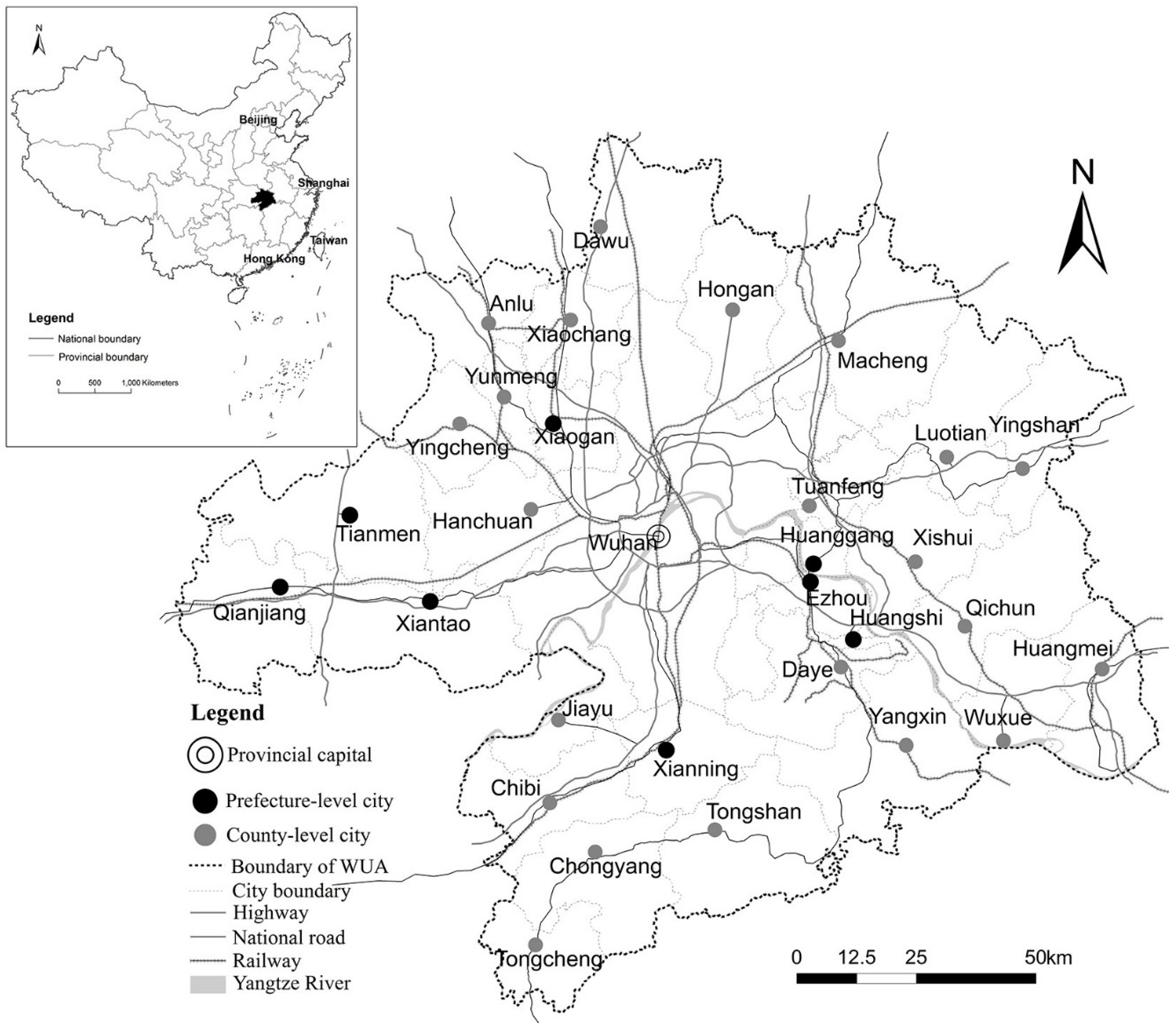
2.1. Study Area

The study area is located within the WUA, particularly in the east of Hubei Province (Figure 1). The WUA consists of one metropolis (Wuhan), eight prefecture-level cities (i.e., Huangshi, Ezhou, Huanggang, Xianning, Xiaogan, Xiantao, Qianjiang, and Tianmen), and 22 county-level cities. This region is home to the most densely populated cities and the largest industry clusters of Hubei province. The WUA covers an area of 58,032 km2, and its population by the end of 2010 reached 30 million people. In 2014, this metropolitan area generated a gross domestic product (GDP) of 1726.5 billion RMB, which accounted for more than 63% of the provincial GDP despite the area having less than 49% of the province’s official population [32]. Wuhan, the center of the WUA and the largest city in central China, has long been regarded as the economic, educational, and industrial focal point of central China. The GDP of Wuhan has increased significantly in the last 9 years, increasing from 135 billion RMB in 2001 to 1006.95 billion RMB in 2014. In recent years, Wuhan has played an important role in boosting the economic development of its surrounding cities. Huangshi, the sub-central city of the WUA, is an important raw material industrial base and is one of the open cities along the rivers approved by the State Council. Ezhou is famous for its numerous lakes and excellent tourism industry. It is also home to the first development zone of Hubei province. Huanggang and Xianning are viewed as the essential transportation hubs connecting the WUA to other metropolitan regions. Xiaogan is a crucial grain-production base rich in cotton and oil. Xiantao, Tianmen, and Qianjiang are prefecture-level cities that are directly governed by the government of Hubei province.

2.2. Data Source

A spatial data set and a statistical data set were used to measure and analyze the urban growth and spatial interaction among the cities in the WUA. The statistical data sets that included information about seven variables, namely, non-agricultural population, GDP, fixed asset investment, total retail sales of consumer goods, urban per capita disposable income, employment in secondary and tertiary industries, and the revenue from post and telecommunication services, in 2000, 2005, and 2010 were obtained from statistical yearbooks issued by the statistical census bureau of the 31 cities. For our study area, each city proper, excluding Ezhou and Wuhan, was designated as a basic unit. Although the Huarong, Echeng, and Liang Zihu districts of Ezhou are independent administrative cells, they are geographically adjacent. Hence, the difference in administrative jurisdiction did not affect our spatial interaction analysis. The 14 districts of Wuhan were taken as a single urban unit because of their blurred built-up area boundaries. Considering our aim to identify the spatial interaction of cities that are separated by distance, we preferred to take Wuhan as a whole in terms of spatial analysis. The central point of each city proper was determined by the center of the central business district (CBD). The spatial data set mainly included the land use/cover change (LUCC) and different levels of road data which was collected from the second land use survey program in China. This road data and the aforementioned point data were used to identify the shortest path between two cities in WUA. The LUCCs for 2000, 2005, and 2010 were mapped using Landsat TM/ETM+ images downloaded from the US Geological Survey. We used the same interpretation method as that used in the study of Tan et al. (2014) to identify the types of land use [19]. The LUCC data were classified into five categories: built-up area, forest, farmland, water body, and bare land.

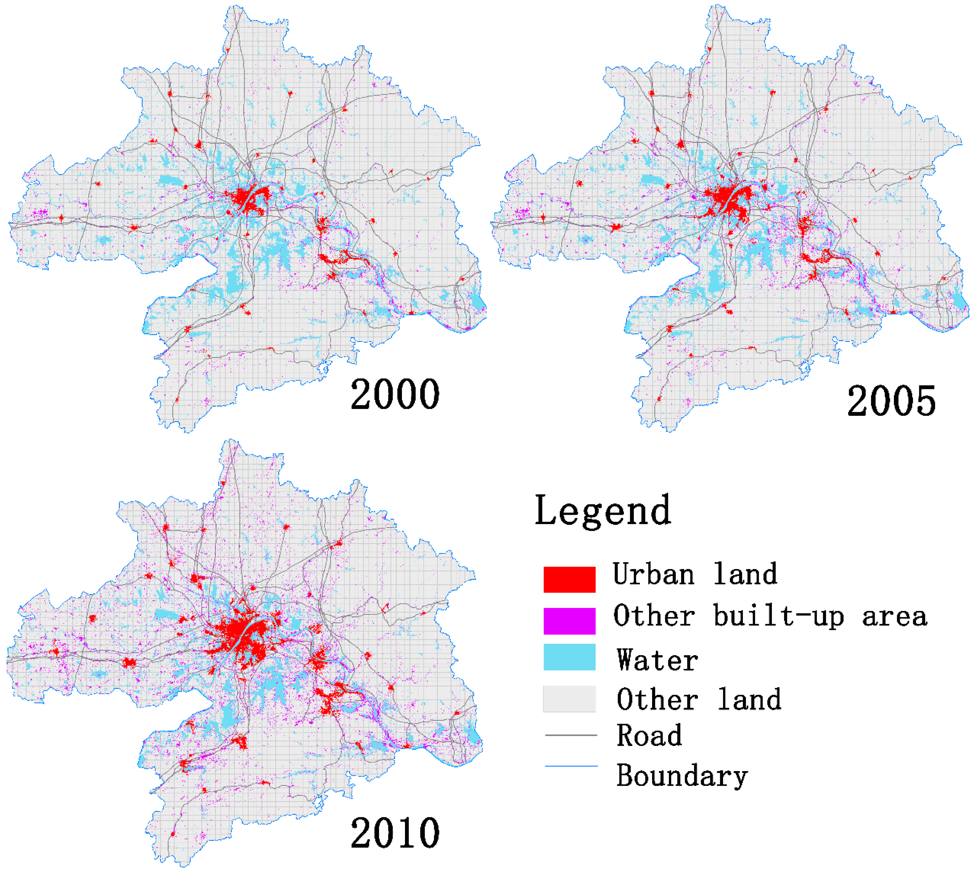
2.3. Identifying the Scope of City Region from Remote Sensing Images

Although the built-up area was easily obtained from the Landsat TM images, the spatial scope of the urban built-up area, peri-urban area, and rural area was difficult to identify because of the similar spectral features. Currently, no specific criterion is used to define urban built-up areas or guide urban geographers in delineating urban region boundaries [33]. Most developed countries use population density (such as USA and Japan), building density, and the area of land parcels (such as England) to distinguish urban built-up areas from peri-urban built-up areas [34,35]. Unlike the cities in developed countries, Chinese cities often lack detailed and reliable population data for estimating the spatial range of the city proper. The population mobility between urban and rural areas increases the difficulty of urban population estimation and decreases the reliability of the population data set. Moreover, building density cannot represent the real morphology of the city proper because the building density in the urban fringe may not be lower than that in the city proper or be greater than that in the CBD. Therefore, in China, the spatial extent of urban built-up areas is always determined by the subjective judgment of planners according to the continuity and area of land parcels derived from land use data.
To obtain the accurate boundaries of urban built-up areas, we used the grid analysis method created by Congalton and Green (2008) in distinguishing the urban built-up areas from rural construction lands [36]. First, the raster data derived from the Landsat images were converted to binary images, with the built-up areas given the value of “1” and with the other land use types given the value of “0”. Next, the binary images were converted into vector data and identified with a 2 km × 2 km fishnet layer by using the Overlay tool in ArcGIS 10.2 (Esri, Redlands, CA, USA). The percentage of built-up areas in each grid was then calculated. If this value was equal to or greater than 50%, then the built-up patch in this grid was regarded as an urban built-up area. If it was between 25% and 50%, then the built-up area in the grid was considered to be an urban fringe. If the value was less than 25%, then the built-up area in the grid was considered to be rural. Most urban built-up area patches were identified with the above method. However, some areas at the edge of the urban patches were split by the fishnet layer. Thus, the resulting small patches were merged with the original patches. Finally, on the basis of the study of Xu and Hua (2005) [35], we checked the urban built-up areas from the initial land use type data according to the following criteria: (1) the area of urban landscape patches in the urban built-up area should be equal to or greater than 0.6 km2; (2) the developed zone and industrial and mining areas connected to urban land patches should be regarded as urban built-up areas; (3) the lakes, green lands, and open spaces located within the urban areas should be considered as urban built-up areas.

2.4. Gravity Model Specification for Measuring Spatial Interaction
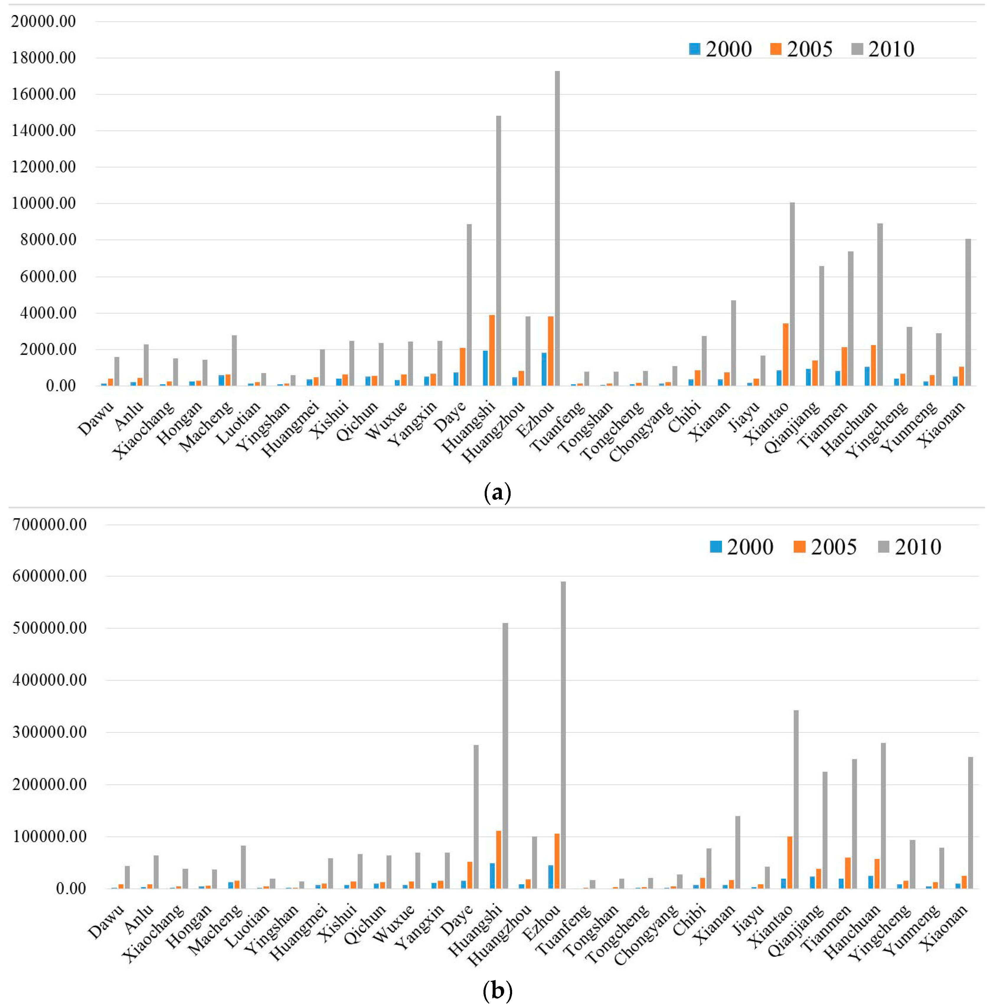
Gravity models have long been used to solve spatial interaction problems in social and regional science [37]. The earliest gravity concept of human interaction was derived from the law of molecular gravitation. Reilly proposed the law of retail gravitation, which suggests that the attractiveness of a retail center is proportional to its population size and is inversely proportional to the square of the distance away from the center. By the early 1940s, Zipf and Stewart applied Newton’s law of gravitation to characterize the spatial interaction between two sites, which follows the form T i j = K Q i Q j D i j 2 , where T i j is the spatial force between city i and city j, Q i and Q j are the population of the two cities, G i and G j are the GDP of the two cities, D i j is the distance between city i and city j, and K is a constant. However, empirical studies have shown that the exponent of distance is not equal to 2 in most cases because the impact of distance is not uniform and should be a variable that is related to the size of the population or to distance itself [24,38]. In addition, the influence of population in different conditions varies with observed data. Thus, the constant value assigned to the population data may not be enough to account for the impact of population. The modified law of gravitation model can be stated as
T i j = K G i α G j β Q i a Q j β D i j λ
where T i j is the spatial force between city i and city j, Q i and Q j are the population of the two cities, G i and G j are the GDP of the two cities, D i j is the distance between city i and city j, and K is a constant. α and β are the scale parameters of population and λ is the distance decay coefficient. The gravity model shows that the total attractiveness of a given city i can be calculated with a potential model, i.e., it is the sum of the spatial interaction of city i with each of the other cities.
V i = T i j   ( j = 1 , 2 , 3 , , n )
where V i is the total interaction produced by all cities with respect to city i. The main drawback of the application of the gravity model is the identification of the population and distance decay coefficients because these values should be attained by regression from empirical data, which are often unavailable. A large number of studies focused on determining the ideal exponents to specify the gravity model and thereby calculate the spatial interaction associated with different types of human activities [39,40,41,42]. In the present study, we employed the three coefficients determined by Zheng et al. (2014) to measure the spatial interaction among the city clusters in the WUA [42]. The results of Zheng et al. (2014) were directly applicable to this case for three reasons. First, it was reasonable to employ the inter-city railway passenger flow to represent the magnitude of the spatial interaction among cities because these data truly reflect population mobility as well as the information and material flows among cities. Second, these datasets were recorded within our study period (2010). Thus, we could neglect the time difference, which usually affects the calibration of these coefficients. Third, the data they used to test the three types of exponents included information about 219 important Chinese cities, which was obtained from the China Statistical Yearbook. Thus, the empirical data were representative and reliable. We should note that in their study, α and β in the gravity model were not specific values but were represented within a specific range. Given that testing all the values provided by Zheng et al. (2014) would be impossible, we chose the maximum and minimum values, i.e., α = β = 0.7, λ = 0.71 and α = β = 0.8, λ = 0.61 were combined to calculate the spatial interaction in the WUA and to determine the influence of the coefficients on the effects of spatial interaction on urbanization.
The geographical distance from the center of one city to the center of another city was calculated on the shortest path by using the Network Analyst tool in ArcGIS 10.2. The total spatial interaction of each city in each year was calculated using the formula in Equations (1) and (2). Using the Statistical Package for the Social Sciences, we ran multiple ordinary least squares regressions (OLS) to analyze the relationship between urbanization and their drivers, including the spatial interaction (SI). The original explanatory variables were represented by the variation of urban population (UP), GDP, total fixed asset investment (FAI), local financial revenue (LFR), social consumable total retail sales (SCTR), per capita disposable income (PCDI), employment in the secondary industry (ESI), employment in the tertiary industry (ETI), post and telecom service revenue (PTSR), and spatial interaction. All variables were normalized and standardized using the max–min normalization method before starting the regression according to the formula:
s = ( V i D m i n ) / ( D m a x D m i n )
where s is the normalized value of V i , V i is the original value of the total potential interaction value of city i, D m i n is the minimum value of V i , and D m a x is the maximum value of V i .

3. Results

The grid analysis method provided a visual representation of the changes in the urban landscape of the WUA between 2000 and 2010. As shown in Figure 2, the cities all witnessed a sharp increase in urban area within the 10-year period, with urban growth being greater than 50% in 28 cities and 100% in six cities. After measuring the area of all the cities in the WUA, we used two combinations of parameters to estimate the spatial interaction of the urban clusters for three years between 2000 and 2010. Figure 3 shows that the absolute value of spatial interaction for each city in each period varied with different scale parameters and distance decay coefficients. However, the spatial interaction for each city presented a similar dynamic trend when it was calculated with different parameters. The values of spatial interaction for each city also increased significantly from 2000 to 2010. The comparisons of the spatial interaction between different cities in the WUA indicated that Wuhan experienced the greatest magnitude of spatial interaction and showed a dominant status in the intra-metropolitan urban clusters, followed by Ezhou and Huangshi.
The traditional variance-in-inflation method was used to exclude multicollinearity problems among the independent variables. GDP, FAI, LFR, and SCTR were excluded from the original model during the two periods. PTSR was also excluded from the original model from 2005 to 2010. The significance of the independent variables was tested with 95% and 99% confidence intervals. Table 1, Table 2, Table 3 and Table 4 present the results of the OLS regression model with different combinations of the coefficients in the gravity model for each of the two periods. All the models were significant to the 0.001 level, with R2 being greater than 0.9 which indicates that the models perform well. The exploratory variables varied with time. Table 5 presents the Akaike information criterion (AIC) test of the models. It can be seen that the AIC values decrease apparently with SI added into the regression models in different parameters and during the two periods, which indicates that SI was an important indicator for urban growth in WUA. SI was found to be positively significant in relation to the dependent variable during the whole study period. This finding suggests that the spatial interaction among the city clusters may have had great influence on the urban growth in the WUA during the rapid urbanization period. UP, ESP, ETP, and SI were the key socioeconomic drivers of urban growth during the period of 2000–2005, whereas SI was the only significant factor related to the urban growth of the WUA during the period of 2005–2010. This finding shows that as time passed, the spatial interaction represented by population migration, information, and commodity flows, etc. played a more important role than the individual socioeconomic drivers of each city did in promoting urbanization in the WUA. Although the absolute values of the coefficients of the explanatory variables differed when using different parameter sets to evaluate the effects of SI, the main significant independent variables and their nature in the regression models of each period showed similar trends, thus indicating that the regression results were minimally influenced.

4. Discussion

Socioeconomic factors, such as economic increase, population growth, industrialization, and land use policy, were considered to be the main driving forces of urban growth in China after the transition from a planned economy to a market-oriented one [10,13]. In addition, spatial determinants related to the accessibility to roads, businesses, education, medical centers, and public service centers were also correlated with the growth of built-up areas in Chinese cities [17,19,43]. Although the literature sheds light on the mechanism of urban land use change from a microscopic perspective, few studies consider the effect of spatial interaction among city clusters when investigating the causes of China’s unprecedented urban growth over the past two decades. Different from the studies of Li et al. (2013), Luo et al. (2009), Tan et al. (2014) and Cheng et al. (2003) [7,17,19,22] we did not identify the spatial determinants of WUA, but tried to explore whether the spatial interaction among cities in WUA had any effects on urban growth. Our study demonstrates that the spatial interaction among the city clusters had a positive correlation with the growth in urban areas during the period of 2000–2005, and that it played a significant role in shaping the urban morphology of the WUA. In addition, our results demonstrate that the employment in the secondary industry (ESI) and the employment in the tertiary industry (ETI) were positively correlated to the urban growth in WUA during 2005–2010, which is similar to the findings of Liao et al. (2007) and Cao et al. (2007) [12,16]. However, these two indicators presented a negative correlation to the urban growth during 2000–2005 as they experienced a decrease in most of the cities. In accord with the study of Dewan et al. (2009), Wu et al. (2012) and Liao et al. (2007) [6,10,12], another significant indicator related to urban growth in this area was urban population. However, the urban population of some cities in WUA witnessed a decline trend during the two periods. In the previous studies [6,8,10,12], GDP was a positive and significant factor of urban growth. However, we did not detect the effect of GDP on urban growth in our model. One of the reasons may be that it has a multicollinearity effect with SI.
Previous research pointed out that large-scale investments in industrial development played a major role in land use change at the Pearl River Delta [44]. To secure more foreign direct investments for the local economy, the local government of the Pearl River Delta set a new special economic zone and enacted privileged development policies for foreign companies; the same was true of the WUA over the past two decades. The Dong Hu High-tech Industrial Zone, Zhuan Kou Economic Development Zone (hubs of high-tech development and automobile production), and Wu Jiashan Development Zone (specializing in food processing) were authorized in the 1990s [30]. This industrial development attracted considerable capital investments and job-seeking migrants who arrived to work as part of the labor force in the largely manufacturing-based enterprises. Wuhan, the center of the WUA, has attracted millions of migrants from surrounding areas over the past 20 years, and the results of our study reveal that the employment in the secondary industry (ESI) and tertiary industry (ETI) also strongly influenced urban expansion in the early stages. The rural–urban migration and labor mobility increased the demand for land development in the core city. Simultaneously, the massive demand for the raw materials of urban construction that had to be obtained from the surrounding areas promoted the local economy, which, in turn, stimulated the urban expansion of the small cities.
Unlike the cities in the Pearl River Delta regions, which have presented a polycentric urban development [45], the cities in the WUA appeared to have a stable hierarchical spatial structure after the reform and opening-up policy. In December 2013, China’s National Development and Reform Commission approved a Regional Development Plan for the WUA (2013–2020), which is aimed at making the WUA a resource-conserving and eco-friendly trial plot and achieving a balanced urban and rural development in the area. In this plan, the spatial structure of regional development for the WUA is characterized as “One Core, One Belt, Three Districts and Four Axes”. In future development, Wuhan is expected to take a leading role in the construction of advanced manufacturing and a modern service industry. At the same time, Huangshi and Ezhou are expected to be raw material production bases, while the prefecture-level cities Xiaogan, Xiantao, Qianjiang, Tianmen, Xianning, and Huanggang are set to focus on food production and the tourism industry. This plan has enhanced the leadership of Wuhan city and may thus aggravate the regional disparity in the WUA to some extent as it permits Wuhan to dominate future capital acquisitions and infrastructure investments. In sum, local leaders seem to find monocentric development more desirable than polycentric development. However, monocentric development patterns may not be the best approach to tackling the challenges of China’s urban transformation. The recent literature and a multitude of current plans favor polycentric urban development in China. More than 90% of Chinese cities show high degrees of polycentricity, and the creation of multiple centers in a number of cities is consistent with their master plans [46]. Polycentric urban forms tend to be valued in economically advanced regions, such as the Beijing–Tianjin–Hebei region (Jing-Jin-Ji) [47], the Pearl River Delta (PRD) [48], and the Yangtze River Delta (YRD) [49], whereas a monocentric urban development is enjoyed widely in less developed regions [46]. With regard to the radiation and driving effects of core cities on surrounding cities, multiple centers, instead of merely one megalopolis, would significantly promote the equilibrium growth of the regional economy because spatial interaction decreases when distances among cities increase. Subcenters, which always take the form of secondary employment centers, can enable small and fringe cities to enjoy remarkable political and economic influence. The same can be especially true in the WUA as the cities close to Wuhan, such as Xiantao, Xiaonan, Huangshi, Daye, and Xianning, have witnessed rapid urban area expansion and economic development, whereas the cities farther away from the core center continue to develop more slowly.
To explore the relationship between spatial interaction and urban growth within an urban cluster area, we used a gravity model based on the scale parameters and distance decay parameters tested by Zheng et al. (2014) [42] to measure the effects of spatial interaction in the WUA. One of the major drawbacks of the gravity-based model is that empirical data are usually not available for calibrating scale and distance decay parameters, and, in fact, the values of these parameters vary with changes in time and space [39,42]. Most of the existing gravity-based research, including a series of spatial access assessment studies, used constant values for parameters and ignored the influence of spatial and temporal disparities [25,26,27,29]. However, it should be noted that the precision of the parameters in the gravity model is of great importance to the measuring accuracy of spatial interaction. To test the difference of the regression results caused by parameter accuracy, we employed the suggested maximum and minimum values of the parameters and found that they did not have a large influence on the exploration of the relationship between the effects of spatial interaction and urban growth in the WUA. However, a comparison of the absolute contribution of the spatial interaction among inter-cities with that of other factors on urban expansion requires additional empirical and historical data to design a highly accurate model.

5. Conclusions

This study analyzed the effects of spatial interaction among city clusters on urban growth. We monitored the urban landscape change of the WUA from 2000 to 2010 by using the grid analysis method. The spatial interaction among the city clusters in the WUA was calculated by a gravity-based model in which two different parameter sets were tested. The effects of spatial interaction and other socioeconomic factors on urban growth were also identified. The spatial interaction among the city clusters in the WUA experienced a significant increase from 2000 to 2010. The regression results suggest that the spatial interaction among the city clusters played a role that was as significant as that of the urban population and employment in the secondary and tertiary industries in driving urban growth in the WUA from 2000 to 2005. However, the effects of spatial interaction were found to be the only socioeconomic factor contributing to urban growth for 2005–2010, thus suggesting that population migration and information and commodity flows had a considerable influence on the promotion of urbanization in the WUA during this period. Although our study does not put forward an advanced technology for measuring the spatial interaction among cities, the spatial interaction of inter-cities was confirmed to be positively correlated with rural–urban land use transition. However, this factor was often neglected by planners and decision makers during regional planning.
This work also had limitations. First, the lack of empirical and historical data on urban flow made calibrating the parameters in the gravity model difficult; therefore, we could not measure the spatial interaction accurately. As there is an urgent need to research and calibrate the gravity-based model of urban geography in China, future studies should concentrate on this area while urban flow datasets at the inter-city level are available. Second, the gravity-based model used to measure the spatial interaction between two cities in this work only covered urban population and GDP information. Other factors, such as natural resource capacity, education level, and facilities and transportation systems, should be considered in future studies. Third, we only tested the effects of spatial interaction on the magnitude of spatial urban growth. Whether and how it impacts growth patterns may help us understand the association between causes and results in urban growth analysis.

Acknowledgments

This research was funded by the MOE (Ministry of Education in China) Liberal Arts and Social Sciences Foundation (Grant No. 16YJC630109 and 16YJC630149). The authors thank Gege Liu, Shuohua Tang and Licai Ming for their help on data processing. The authors would also like to thank Yaolin Liu and Liming Jiao for their valuable comments and suggestions.

Author Contributions

Ronghui Tan and Hengzhou Xu conceived and designed the experiments; Kehao Zhou performed the experiments; Ronghui Tan and Kehao Zhou analyzed the data; Qingsong He contributed reagents/materials/analysis tools; Ronghui Tan wrote the paper.

Conflicts of Interest

The authors declare no conflict of interest. The founding sponsors had no role in the design of the study, in the collection, analyses, or interpretation of data, in the writing of the manuscript, or in the decision to publish the results.

References

  1. Fang, C.; Song, J.; Zhang, Q.; Ming, L.I. The formation, development and spatial heterogeneity patterns for the structures system of urban agglomerations in China. Acta Geogr. Sin. 2005, 60, 827–840. [Google Scholar]
  2. Haase, D.; Haase, A.; Kabisch, N.; Kabisch, S.; Rink, D. Actors and factors in land-use simulation: The challenge of urban shrinkage. Environ. Model. Softw. 2012, 35, 92–103. [Google Scholar] [CrossRef]
  3. Bhatta, B.; Saraswati, S.; Bandyopadhyay, D. Quantifying the degree-of-freedom, degree-of-sprawl, and degree-of-goodness of urban growth from remote sensing data. Appl. Geogr. 2010, 30, 96–111. [Google Scholar] [CrossRef]
  4. Fang, C.L. New structure and new trend of formation and development of urban agglomerations in China. Sci. Geogr. Sin. 2011, 31, 1025–1034. [Google Scholar]
  5. Ma, Y.; Xu, R. Remote sensing monitoring and driving force analysis of urban expansion in Guangzhou City, China. Habitat Int. 2010, 34, 228–235. [Google Scholar] [CrossRef]
  6. Dewan, A.M.; Yamaguchi, Y. Land use and land cover change in Greater Dhaka, Bangladesh: Using remote sensing to promote sustainable urbanization. Appl. Geogr. 2009, 29, 390–401. [Google Scholar] [CrossRef]
  7. Li, X.; Zhou, W.; Ouyang, Z. Forty years of urban expansion in Beijing: What is the relative importance of physical, socioeconomic, and neighborhood factors? Appl. Geogr. 2013, 38, 1–10. [Google Scholar] [CrossRef]
  8. Deng, X.; Huang, J.; Rozelle, S.; Uchida, E. Economic growth and the expansion of urban land in China. Urban Stud. 2010, 47, 813–843. [Google Scholar] [CrossRef]
  9. Lu, C.; Wu, Y.; Shen, Q.; Wang, H. Driving force of urban growth and regional planning: A case study of China’s Guangdong Province. Habitat Int. 2013, 40, 35–41. [Google Scholar] [CrossRef]
  10. Wu, K.Y.; Zhang, H. Land use dynamics, built-up land expansion patterns, and driving forces analysis of the fast-growing Hangzhou metropolitan area, eastern China. Appl. Geogr. 2012, 34, 137–145. [Google Scholar] [CrossRef]
  11. Zhao, K.; Zhang, A.; Li, P. Driving forces of urban construction land expansion: An empirical analysis based on panel data of provinces. J. Nat. Resour. 2011, 26, 1323–1332. [Google Scholar]
  12. Liao, H.; Peng, Z.; Hong, H.; Cheng, X. Research on dynamic mechanism and model of urban spatial expansion since the establishment of Chongqing Municipality. Geogr. Res. 2007, 26, 1137–1146. [Google Scholar]
  13. Yue, W.; Liu, Y.; Fan, P. Measuring urban sprawl and its drivers in large Chinese cities: The case of Hangzhou. Land Use Policy 2013, 31, 358–370. [Google Scholar] [CrossRef]
  14. Wu, H.; Jiang, J.; Zhou, J.; Zhang, H.; Zhang, L.; Ai, L. Dynamics of urban expansion in Xi’an city using Landsat TM/ETM+ data. Acta Geogr. Sin. 2005, 60, 143–150. [Google Scholar]
  15. Han, S. Urban expansion in contemporary China: What can we learn from a small town? Land Use Policy 2010, 27, 780–787. [Google Scholar] [CrossRef]
  16. Cao, Y.; Wang, J.; Ning, X. Path analyses of driving forces of urban constructive land in three gorges. China Popul. Resour. Environ. 2007, 16, 66–69. [Google Scholar]
  17. Luo, J.; Wei, Y.H.D. Modeling spatial variations of urban growth patterns in Chinese cities: The case of Nanjing. Landsc. Urban Plan. 2009, 91, 51–64. [Google Scholar] [CrossRef]
  18. Poelmans, L.; Rompaey, A.V. Detecting and modelling spatial patterns of urban sprawl in highly fragmented areas: A case study in the Flanders-Brussels region. Landsc. Urban Plan. 2009, 93, 10–19. [Google Scholar] [CrossRef]
  19. Tan, R.; Liu, Y.; Liu, Y.; He, Q.; Ming, L.; Tang, S. Urban growth and its determinants across the Wuhan urban agglomeration, central China. Habitat Int. 2014, 44, 268–281. [Google Scholar] [CrossRef]
  20. Vermeiren, K.; Rompaey, A.V.; Loopmans, M.; Serwajja, E.; Mukwaya, P. Urban growth of Kampala, Uganda: Pattern analysis and scenario development. Landsc. Urban Plan. 2012, 106, 199–206. [Google Scholar] [CrossRef]
  21. Zhang, Z.; Su, S.; Xiao, R.; Jiang, D.; Wu, J. Identifying determinants of urban growth from a multi-scale perspective: A case study of the urban agglomeration around Hangzhou Bay, China. Appl. Geogr. 2013, 45, 193–202. [Google Scholar] [CrossRef]
  22. Cheng, J.; Masser, I. Urban growth pattern modeling: A case study of Wuhan city, PR China. Landsc. Urban Plan. 2003, 62, 199–217. [Google Scholar] [CrossRef]
  23. Limtanakool, N.; Schwanen, T.; Dijst, M. Ranking functional urban regions: A comparison of interaction and node attribute data. Cities 2007, 24, 26–42. [Google Scholar] [CrossRef]
  24. Carrothers, G.A.P. An historical bedew of the gravity and potential concepts of human interaction. J. Am. Inst. Plan. 1956, 22, 94–102. [Google Scholar] [CrossRef]
  25. Dock, J.P.; Song, W.; Lu, J. Evaluation of dine-in restaurant location and competitiveness: Applications of gravity modeling in Jefferson County, Kentucky. Appl. Geogr. 2014, 60, 204–209. [Google Scholar] [CrossRef]
  26. Schuurman, N.; Berube, M.; Crooks, V.A. Measuring potential spatial access to primary health care physicians using a modified gravity model. Can. Geogr. 2010, 54, 29–45. [Google Scholar] [CrossRef]
  27. Wan, N.; Zhan, F.B.; Zou, B.; Chow, E. A relative spatial access assessment approach for analyzing potential spatial access to colorectal cancer services in Texas. Appl. Geogr. 2012, 32, 291–299. [Google Scholar] [CrossRef]
  28. He, C.; Zhao, Y.; Tian, J.; Shi, P. Modeling the urban landscape dynamics in a megalopolitan cluster area by incorporating a gravitational field model with cellular automata. Landsc. Urban Plan. 2013, 113, 78–89. [Google Scholar] [CrossRef]
  29. Natale, F.; Borrello, A.; Motova, A. Analysis of the determinants of international seafood trade using a gravity model. Mar. Policy 2015, 60, 98–106. [Google Scholar] [CrossRef]
  30. Du, N.; Ottens, H.; Sliuzas, R. Spatial impact of urban expansion on surface water bodies—A case study of Wuhan, China. Landsc. Urban Plan. 2010, 94, 175–185. [Google Scholar] [CrossRef]
  31. Zhou, K.; Liu, Y.; Tan, R.; Song, Y. Urban dynamics, landscape ecological security, and policy implications: A case study from the Wuhan area of central China. Cities 2014, 41, 141–153. [Google Scholar] [CrossRef]
  32. Hubei Statistics Bureau. Hubei Statistical Yearbook. 2015. Available online: http://www.stats-hb.gov.cn/tjgb/ndtjgb/hbs/112361.htm (accessed on 20/03/2016). (In Chinese) [Google Scholar]
  33. Bhatta, B.; Saraswati, S.; Bandyopadhyay, D. Urban sprawl measurement from remote sensing data. Appl. Geogr. 2010, 30, 731–740. [Google Scholar] [CrossRef]
  34. Hu, Y.; Wu, Z.; Xiong, W.; Pan, C. The research on the method of city proper boundary identifying—A case study of Wuhan city. City Plan. Rev. 2008, 32, 88–92. [Google Scholar]
  35. Xu, Q.; Hua, C. Establishing a uniform standard for calculation of urban builtup area: With Hangzhou central city zone as an example. Planners 2005, 21, 88–91. [Google Scholar]
  36. Congalton, R.G.; Green, K. Assessing the Accuracy of Remotely Sensed Data: Principles and Practices; CRC Press: Boca Raton, FL, USA, 2008. [Google Scholar]
  37. Roy, J. Spatial Interaction Modelling: A Regional Science Context, Advances in Spatial Science; Springer-Verlag: Berlin, Germany, 2004. [Google Scholar]
  38. Anderson, T.R. Intermetropolitan migration: A comparison of the hypotheses of Zipf and Stouffer. Am. Sociol. Rev. 1955, 20, 287–291. [Google Scholar] [CrossRef]
  39. Dai, T.; Li, Y. Temporal variations in parameter s of gravity model: An analysis on china’s inter-city railway passenger flows. Progr. Geogr. 2008, 27, 110–116. [Google Scholar]
  40. Li, S.; Wang, Z.; Zhong, Z. Gravity model for tourism spatial interaction: Basic form, parameter estimation, and applications. Acta Geogr. Sin. 2012, 67, 526–544. [Google Scholar]
  41. Luo, W.; Wang, F. Measures of spatial accessibility to health care in a GIS environment: Synthesis and a case study in the Chicago region. Environ. Plan. B Plan. Des. 2003, 30, 865–884. [Google Scholar] [CrossRef]
  42. Zheng, Q.; Dai, T.; Tao, Z.; Zhang, M. Spatial heterogeneity of gravity model parameters: A case study of inter-city railway passenger flow in China. Progr. Geogr. 2014, 33, 1659–1665. [Google Scholar]
  43. Shu, B.; Zhang, H.; Li, Y.; Qu, Y.; Chen, L. Spatiotemporal variation analysis of driving forces of urban land spatial expansion using logistic regression: A case study of port towns in Taicang City, China. Habitat Int. 2014, 43, 181–190. [Google Scholar] [CrossRef]
  44. Seto, K.C.; Kaufmann, R.K. Modeling the drivers of urban land use change in the Pearl River Delta, China: Integrating remote sensing with socioeconomic data. Land Econ. 2003, 79, 106–121. [Google Scholar] [CrossRef]
  45. Fragkias, M.; Seto, K.C. Evolving rank-size distributions of intra-metropolitan urban clusters in South China. Comput. Environ. Urban Syst. 2009, 33, 189–199. [Google Scholar] [CrossRef]
  46. Liu, X.; Wang, M. How polycentric is urban China and why? A case study of 318 cities. Landsc. Urban Plan. 2016, 151, 10–20. [Google Scholar] [CrossRef]
  47. Qin, B.; Han, S.S. Emerging polycentricity in Beijing: Evidence from housing price variations, 2001–2005. Urban Stud. 2013, 50, 2006–2023. [Google Scholar] [CrossRef]
  48. Wu, F. Polycentric urban development and land-use change in a transitional economy: The case of Guangzhou. Environ. Plan. A 1998, 30, 1077–1100. [Google Scholar] [CrossRef]
  49. Wen, H.; Tao, Y. Polycentric urban structure and housing price in the transitional China: Evidence from Hangzhou. Habitat Int. 2015, 46, 138–146. [Google Scholar] [CrossRef]
Figure 1. Location of the study area.
Sustainability 08 00759 g001
Figure 2. The urban area change from 2000 to 2010 in Wuhan urban agglomeration (WUA).
Sustainability 08 00759 g002
Figure 3. The spatial interaction change with different parameters in the gravity models. (a) The spatial interaction change with α = β = 0.7, λ = 0.71; (b) The spatial interaction change with α = β = 0.8, λ = 0.61.
Sustainability 08 00759 g003
Table 1. Regression results of the determinants of urban growth in WUA from 2000 to 2005 with α = β = 0.7, λ = 0.71 (n = 31).
VariablesUnstandardized CoefficientsStandardized CoefficientstSig.Collinearity Statistics
BStd. ErrorBetaToleranceVIF
(Constant)0.1280.037 3.4080.002
UP−0.0990.045−0.119−2.1960.0380.3422.924
PCDI−0.0350.029−0.048−1.2120.2370.6431.555
ESI−0.1070.033−0.138−3.2160.0040.5491.822
ETI−0.1390.065−0.134−2.1290.0430.2553.920
SI1.1310.0771.15814.6890.0000.1626.165
R2: 0.975; Adjusted R2: 0.970; Std. Error of the Estimate: 0.031.
Table 2. Regression results of the determinants of urban growth in WUA from 2005 to 2010 with α = β = 0.7, λ = 0.71 (n = 31).
VariablesUnstandardized CoefficientsStandardized CoefficientstSig.Collinearity Statistics
BStd. ErrorBetaToleranceVIF
(Constant)0.0000.058 −0.0070.994
UP−0.0600.080−0.061−0.7520.4590.4822.075
PCDI0.0900.0760.0941.1900.2460.5071.974
ESI0.1470.1190.1311.2350.2290.2823.540
ETI0.0140.0740.0160.1930.8480.4632.161
PTSR−0.0600.059−0.059−1.0080.3240.9261.080
SI0.8480.1670.8225.0660.0000.1218.273
R2: 0.924; Adjusted R2: 0.905; Std. Error of the Estimate: 0.057.
Table 3. Regression results of the determinants of urban growth in WUA from 2000 to 2005 with α = β = 0.8, λ = 0.61 (n = 31).
VariablesUnstandardized CoefficientsStandardized CoefficientstSig.Collinearity Statistics
BStd. ErrorBetaToleranceVIF
(Constant)0.1310.038 3.4330.002
UP−0.0860.045−0.103−1.9080.0680.3512.847
PCDI−0.0310.029−0.042−1.0480.3050.6491.540
ESI−0.1130.034−0.146−3.3550.0030.5451.835
ETI−0.1420.066−0.136−2.1330.0430.2543.936
SI1.1140.0771.14314.4980.0000.1666.020
R2: 0.974; Adjusted R2: 0.969; Std. Error of the Estimate: 0.031.
Table 4. Regression results of the determinants of urban growth in WUA from 2005 to 2010 with α = β = 0.8, λ = 0.61 (n = 31).
VariablesUnstandardized CoefficientsStandardized CoefficientstSig.Collinearity Statistics
BStd. ErrorBetaToleranceVIF
(Constant)−0.0090.058 −0.1550.878
UP−0.0490.081−0.050−0.6060.5500.4912.038
PCDI0.1000.0770.1051.3100.2030.5141.945
ESI0.1600.1200.1431.3310.1960.2863.494
ETI0.0230.0750.0250.3010.7660.4692.133
PTSR−0.0600.060−0.060−1.0020.3260.9231.083
SI0.8120.1670.7894.8740.0000.1267.924
R2: 0.921; Adjusted R2: 0.901; Std. Error of the Estimate: 0.058.
Table 5. Results of the AIC test (n = 31).
α = β = 0.7, λ = 0.71α = β = 0.8, λ = 0.61
2000–20052005–20102000–20052005–2010
Without SI−142.42−151.26−142.42−151.26
With SI−210.07−171.94−210.07−170.75

