Article

Modeling the Habitat of the Red-Crowned Crane (Grus japonensis) Wintering in Cheorwon-Gun to Support Decision Making

1
Interdisciplinary Program in Landscape Architecture, Seoul National University, Seoul 08826, Korea
2
Daejeon Development Institute, 160-20 Wolpyeong-dong, Seo-gu, Daejeon 302-280, Korea
3
Department of Landscape Architecture, University of Seoul, Seoul 08826, Korea
4
Korea Institute of Environmental Ecology, Seoul 138-120, Korea
5
Department of Landscape Architecture and Rural System Engineering, Seoul National University, Seoul 151-921, Korea
6
Department of Forest Sciences, Seoul National University, Seoul 151-921, Korea
*
Author to whom correspondence should be addressed.
Sustainability 2016, 8(6), 576; https://doi.org/10.3390/su8060576
Submission received: 23 March 2016 / Revised: 12 June 2016 / Accepted: 14 June 2016 / Published: 18 June 2016
(This article belongs to the Special Issue Sustainable Wildlife Management)

Abstract

:
Cheorwon-gun is an important wintering area for the red-crowned crane (Grus japonensis). Although eco-tourism has been recently proposed as a means to stimulate the local economy, it may have adverse effects on the crane. We believe a science-based conservation plan is needed to mitigate these negative effects. To this end, our study had three objectives: (1) to analyze the red-crowned crane habitat and its suitability in Cheorwon-gun, using field surveys and habitat modeling; (2) to check the feasibility of alternative habitat patches across demilitarized zones (DMZs); and (3) to propose a conceptual diagram that minimizes habitat loss during development activities. We aim to quantify habitat suitability, the farmland area needed to support existing crane populations in wintertime, disturbance caused by human activities, and vehicular spatial patterns. These data could be used in spatial planning. The framework of this study and the process of making a conceptual diagram could be applied to other areas where there is a conflict between development and habitat conservation.

1. Introduction

There are 15 crane species in the world, seven of which migrate to the Republic of Korea (ROK) for wintering [1]. The red-crowned crane (Grus japonensis) is an endangered species according to the Red List of International Union for Conservation of Nature and Natural Resources (IUCN) [2]. It breeds in southeastern Russia, northeastern China, Mongolia, and on Hokkaido Island in eastern Japan. After breeding, red-crowned cranes migrate to the ROK and coastal China and overwinter there [3]. Wintering sites are very important for migratory birds during the time following the breeding period [4].
Many red-crowned cranes overwinter at Cheorwon-gun, ROK [5,6], a major crane wintering site since 2009 [7]. It includes large civilian controlled zones (CCZs) and demilitarized zones (DMZs) between North Korea and ROK, which have limited development activities and created favorable conditions for birds there. Due to its natural resources, however, Cheorwon-gun has great potential as a tourist region and requirements for infrastructures like public parks and paved roads have recently increased [8]. The Cheorwon-gun government is interested in these developments but has no specific plan to preserve red-crowned crane habitats.
Studies have been performed on crane stopover and wintering sites [9,10], breeding sites [11,12], habitat selection and change [13], behavioral characteristics [14], and home range and migration routes [3], but only a few assessed winter habitat suitability for red-crowned cranes. In Cheorwon-gun, studies are very limited because it is difficult to conduct field surveys in military sites. The Ministry of Environment of the ROK, however, permitted field surveys in Cheorwon-gun for the present study. Consequently, red-crowned crane habitat suitability in Cheorwon-gun could be assessed and the data used to help establish a conservation plan.
This study had three main objectives: (1) to establish a habitat model for red-crowned cranes wintering in Cheorwon-gun based on crane observation data and environmental conditions, and then use it to determine crane core habitats and their properties; (2) to find alternative habitats for red-crowned cranes outside of Cheorwon-gun in case the existing areas are affected by development and tourism; and (3) to propose a conceptual crane conservation plan framework and prevent the negative effects of development on this crane species. The results of this study will provide a solid basis for establishing a crane habitat conservation plan and may be used to protect valuable habitats in other countries.

2. Materials and Methods
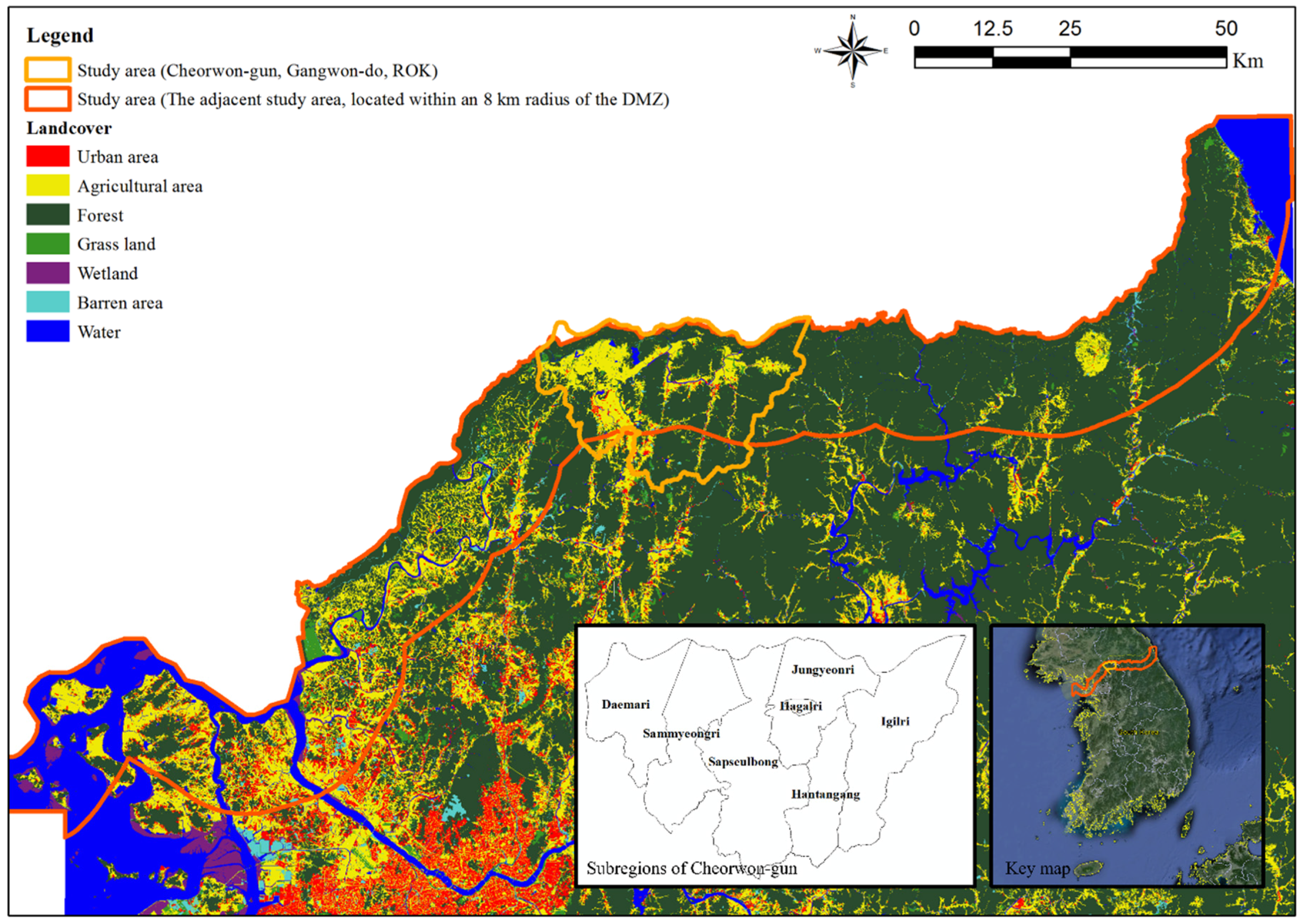
2.1. Study Scope

The selected target species is the red-crowned crane (Grus japonensis). It is the most highly endangered of the genus. First, we reviewed earlier studies on red-crowned cranes and methods of evaluating habitat suitability. We then gathered red-crowned crane presence data and selected and optimized the model for the Cheorwon-gun area. Next, we mapped and analyzed Cheorwon-gun habitats. We also assessed other areas near the DMZs as potential alternative red-crowned crane habitats. Finally, we proposed a conceptual diagram to support a conservation plan and prevent the negative effects of development on the red-crowned crane.
This study was conducted from October 2009 to March 2010 and covered the wintering season of the red-crowned crane. Since Cheorwon-gun has large CCZs and DMZs, the ROK government granted permission to run field surveys. Two areas were selected: one was Cheorwon-gun, Gangwon-do (ROK), an important wintering area for red-crowned cranes (Figure 1). A habitat suitability model was established and habitat characteristics were analyzed for red-crowned cranes wintering in this area, which was also used for crane presence data collection. For the purpose of finding alternative crane wintering habitats, a second study area was selected within an 8 km radius of the DMZ (Figure 1). Owing to the strict military security regulations there, this area was seldom affected by development.

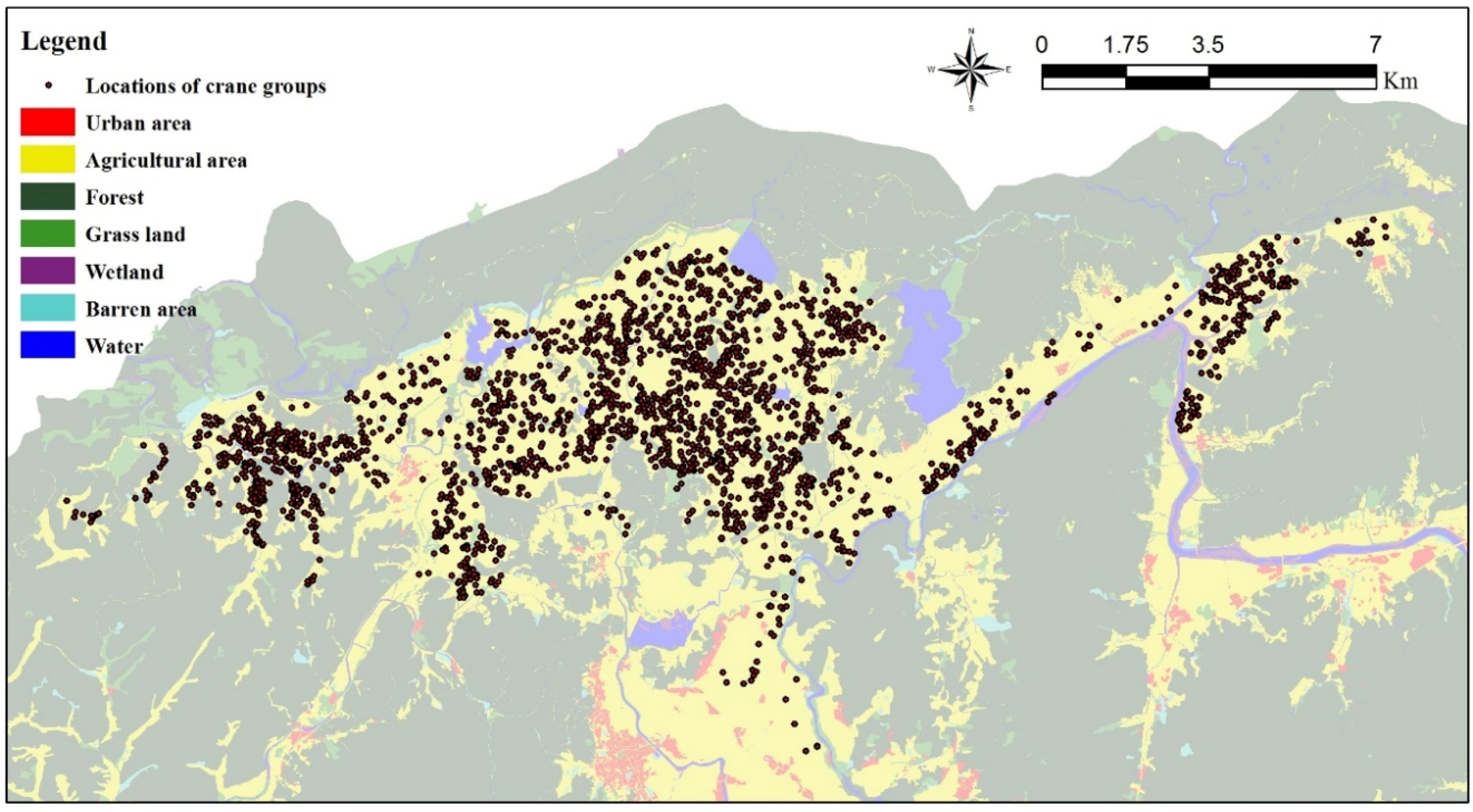
2.2. Field Surveys for Collecting Presence Data

Crane presence data were collected during the wintering season. Field surveys were conducted six times (2009: 30 October, 14 November and 19 December 2010: 9 January, 19 February and 13 March) in Cheorwon-gun. The survey schedule was selected according to weather conditions and military authority regulations. The field survey area was divided into four sub-areas by location: (1) Jungyeon-ri, Igil-ri, and Hagal-ri; (2) Sapseulbong; (3) Daema-ri and Sammyeong-ri; and (4) Hantang-river and Dongsong-eup. These sub-areas were surveyed simultaneously to collect reliable presence data.
Field surveys were conducted by four teams, one in each sub-area. Each team consisted of two people who used a motor vehicle to move through the area. Data were collected around noon, which is the crane feeding time. When a group of cranes was observed, the survey team stopped the vehicle far away from them, counted them, and noted their location within rectangular rice paddies. Cranes usually made a group that consisted of three to five members, and thus we recorded a group of cranes as one location. Crane locations were marked on a topographical map with a corresponding symbol and coordinate. Symbols and coordinates were then collected and marked on a geographical information systems (GIS) map.
For all subareas, the maximum and minimum numbers of cranes sighted were 863 (December 2009) and 11 (October 2009) respectively (Table 1). The number of red-crowned cranes sighted was highest in Sapseulbong and lowest in Hantan-river and Dongsong-eup. All data from October 2009 to March 2010 were used for further analysis.
Presence data collected from the field survey was fed into a digital map using the coordinates of each point (Figure 2). All incidents of crane landing and taking-off were recorded and compared with other researcher’s maps to avoid double counting. We used these data as model inputs. The survey team also collected information and photographs of food traces and droppings to confirm location data.

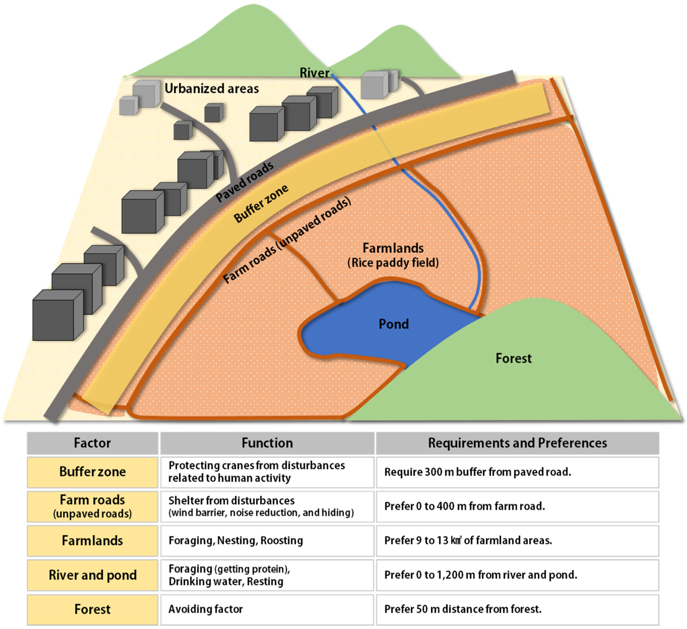
2.3. Habitat Suitability Analysis

Most studies on the habitat characteristics of a single species focus on presence/absence data in a sampling area [15]. Target species absence data, however, tend to be poor compared to species presence data [16]. Hence, in order to perform a proper presence/absence data analysis, areas where no animals were spotted, and which do not have suitable habitat conditions, should be selected, as well as appropriate habitats where animals have been seen [17]. Nevertheless, the precision of this method may be compromised since it relies upon random site selection from areas where the species has not been found. Phillips et al. [18] suggest that, when presence alone has been surveyed, species distribution should be plotted using a maximum entropy model rather than a presence/absence model. Thus, we used a maximum entropy model to analyze crane habitat suitability.
Crane habitat preference is related to food availability [19], disturbance agents [20,21], and sleeping places [22]. Research on crane sleeping sites is limited since nocturnal access to this area is restricted. On the other hand, there are many studies on food resources in the area. Cranes prefer rice paddies with abundant grain and are affected by disturbance factors such as automobile traffic.
Based on a literature review, nine variables that affect crane habitats were selected. Land cover type was used as categorical variable. Variables related to distance included the distance from a farmland, a farm road (unpaved road), a paved road, a residential area, a river, and a forest. Farmland area was included as an area-related variable. The land cover type enabled the identification of the land cover preferred by cranes, whereas distance-related factors helped to identify the preferred environmental characteristics. The distance to farmland may also help to identify crane preferences in relation to environmental change of the area. Each variable was created as a 30-m2 raster data.
A detailed method for setting the presence data was needed to make an appropriate model. Since model performance may differ between data sets, we assessed 10 random data subsets [18]. The model was based on data from 3222 locations. Three-quarters (2417) of the points were randomly selected, and 10,000 random background pixels were used as negative instances and training data. One-quarter (805) of the points were used for model testing. During the model run, a five-fold cross-validation was applied to minimize errors that occurred in the process of making crane location training data. Meanwhile, we obtained very similar habitat properties among modeling results of each observation period. Thus, we decided to use all period data for modeling habitat suitability.
The response curve function provided information on the relationship between presence points and environmental characteristics. Linear, quadratic, product, hinge, and categorical functions were selected as variables of the model. The maximum number of iterations was set to 1000 and the convergence threshold was set to 10−5 in the advanced tab. The regularization multiplier was set to one, and the maximum number of background points was set to 10,000 in the basic tab. To assess model performance, a receiver operating characteristic (ROC) analysis was undertaken. The ROC analysis compared Maxent model results with random predictions. Model performance can also be evaluated by using the Area Under the Curve (AUC) value.
After building an optimal model for Cheorwon-gun (a study area), it was applied to the zone within an 8 km radius of the DMZ (another study area) to find alternative potential habitats for red-crowned cranes. A projection function was used to assess the potential habitats. This helps analyze the habitat suitability of an area lacking presence data by using a model for another area. Data from the same variables used in Cheorwon-gun were used in the adjacent area.

3. Results

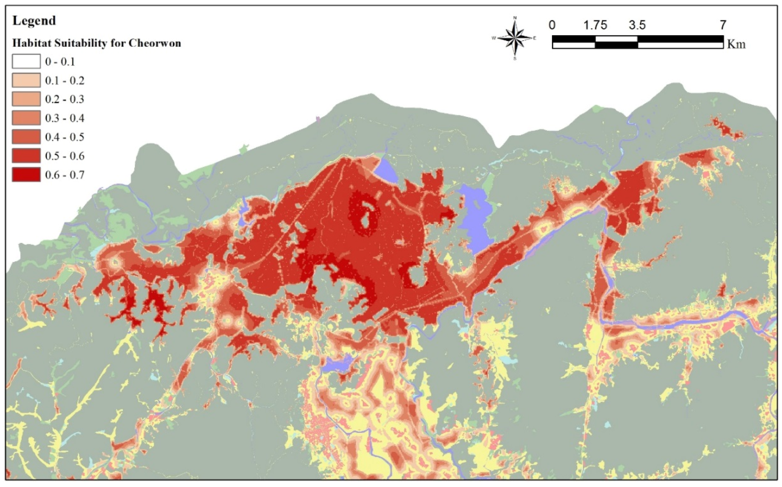
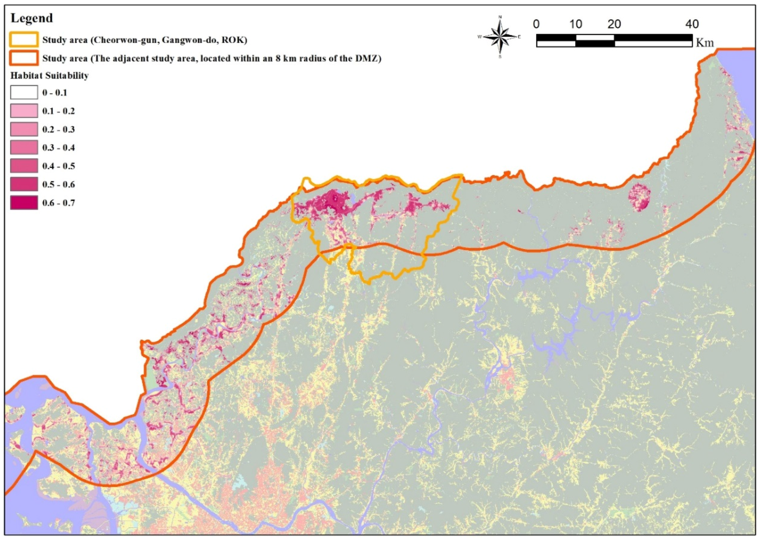
3.1. Habitat Suitability Model for Cheorwon-Gun

A model based on seven variables was built using data on crane presence in Cheorwon-gun. It included a categorical variable (land cover type) and six continuous variables (distance from a farmland, distance from a farm road, distance from a paved road, distance from the river, distance from the forest, and area of the farmland). The AUC value of the model was 0.871, meaning that the model was highly accurate [23]. There were no major differences among results from the five-fold cross-validation; thus, the model performed well.
Areas with high habitat suitability indices were highly correlated to the presence points (Figure 3). Most farmland was very suitable but some adjacent to the road and the forest had low habitat potential. The 10-percentile training presence logistic threshold was set to 0.375, so areas with suitability indices greater than 0.375 were considered to be preferred crane habitats.

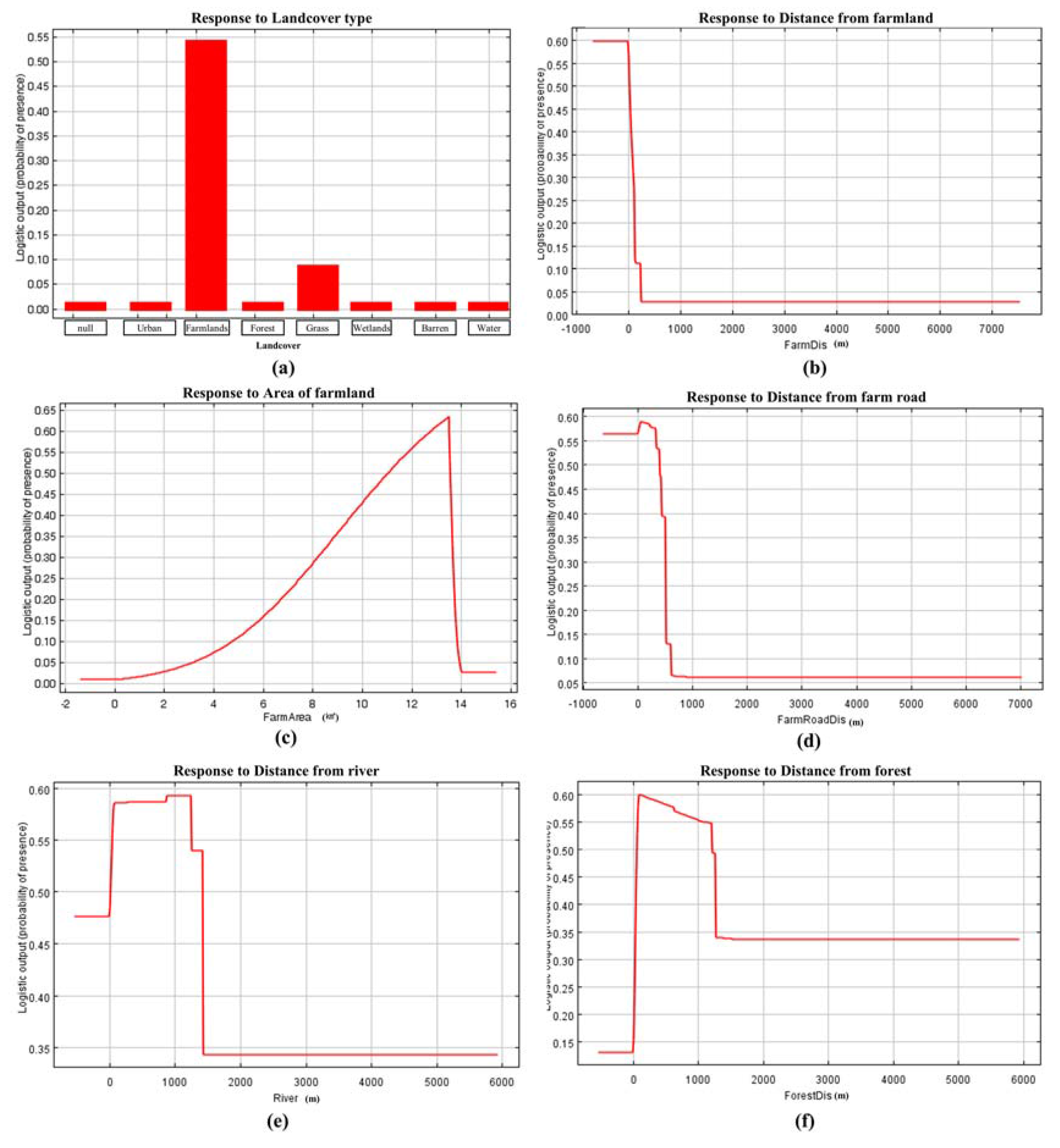
3.2. Relationship between Crane Presence and Variables

Farmland was very important foraging, nesting and roosting area for red-crowned cranes in Cheorwon-gun. It had the highest crane presence probabilities of all the land cover types (Figure 4a). Almost all cranes were found either on the farmland or very close to it (Figure 4b). Large tracts of farmland showed high occurrence probabilities. The maximum input data farmland area is 13 km2. It is therefore likely that the occurrence probability is proportional to the farmland area (Figure 4c). These three graphs showed the importance of farmland as crane habitat and corroborate previous studies [5,19,20,24]. Studies in China, however, suggested that wetlands are the main crane habitats [7,25,26]. We propose that this difference is due to the fact that there are no large wetlands in Cheorwon-gun, so cranes use farmland as their main habitat instead.
Cranes also preferred areas within 400 m of farm roads (Figure 4d). Cranes foraged near farm roads during the field survey since wind-blown grains accumulated there and were easily accessible to the cranes.
Small rivers and ponds were considered the same factor because it was difficult to classify them. According to a previous study, red-crowned cranes must feed at a river in order to obtain proteins they cannot get from farmland grains [27]. In Cheorwon-gun, cranes were seen at rivers and ponds feeding on fish and other animals. It has also been suggested that some riverside areas provide sleeping sites for cranes [7]. Cranes preferred areas less than 1200 m from rivers or ponds (Figure 4e). Field surveys and model results suggest that Cheorwon-gun cranes use rivers and ponds as foraging sites for protein sources, for drinking water and as resting sites.
Cranes usually avoided forests because predators live in them and the tree branches are flight obstacles [28]. The analysis showed that cranes preferred 50 m distance from forests (Figure 4f). Crane presence probabilities rapidly decrease more than 1200 m from a forest since forests in the area are only 1200 m apart or less. Results showed that cranes prefer areas with a wide horizontal visibility where they can easily see predators like the wildcat (Felis bengalensis euptilura). Moreover, in forested areas, it is difficult for cranes to escape from predators [26].

4. Discussion

The amount of farmland in an area is significantly correlated to the availability of food [19,29]. The suitable habitat area of the red crowned cranes in Cheorwon-gun is about 80 km2, and a large amount of it is farmland. The existing farmland area in the region is adequate to sustain a crane community there. Nevertheless, if cultivation practices were changed there to make more food available, then even larger crane communities could live in Cheorwon-gun.
Farmland is the main crane habitat in Cheorwon-gun. In other regions, wetlands are also important crane habitats [5,30,31]. In Cheorwon-gun, however, farmland is much more accessible as a crane food source since there are very few wintertime disturbances from human activity there. If disturbances increased, though, cranes could migrate to other regions and use wetlands instead of farmland as habitats.
We found that cranes also prefer areas near farm roads. Since there is no wintertime farming in Cheorwon-gun, there is very little human- or vehicular farm road traffic and therefore limited disturbance there. Farm roads are higher than farmland because they were constructed on an embankment. Therefore, farm roads provide shelter from strong winds. Additionally, winds move grain to the edge between farmland and farm roads [30].
In view of the regional development plan for migratory birds, we tried to find alternative crane habitat areas adjacent to the DMZs (Figure 5). We could not find an alternative site that would support the existing Cheorwon-gun crane community. The DMZs are the only place in the ROK where there are few human disturbances. However, it is difficult to sustain the present crane community there since there are no large tracts of farmland in the area except for those in Cheorwon-gun, although we also observed small crane communities in the western sea due to food shortages. We therefore conclude that, based on our analysis, there is no suitable alternative crane habitat in that region. Of the total number of suitable habitats, 57.02% (87.99 km2) were located in Cheorwon-gun (Table 2).
Based on the information derived from the habitat suitability model, a conceptual diagram that factored in the characteristics of Cheorwon-gun was made to support the establishment of a conservation plan for preferred crane areas (Figure 6). Nevertheless, areas within an 8 km radius of the DMZ resembled Cheorwon-gun, so this diagram may be applied to other potential crane habitats. The diagram emphasizes the function, requirements, and preferences of the various factors related to red-crowned crane habitat conservation.

5. Conclusions

The objectives of this study were to analyze the habitat suitability of Cheorwon-gun for red-crowned cranes using field surveys and habitat modeling, and to find alternative habitats near demilitarized zones (DMZs). The study revealed an interesting relationship between the distance to a farm road (unpaved) and the presence of red-crowned cranes. Farm roads provide shelter from disturbances such as vehicles and wind, because the shapes of farm roads mimic an embankment. In addition, grain is found in the edge between farmland and farm roads because winds move grain to this area. Although farm roads were made for humans, farm roads provide suitable environmental conditions for cranes. They are also good crane foraging sites. Decision makers of Cheorwon-gun might therefore consider the synergy between the cranes and facilities related to human activities.
Yeoncheon-gun and Paju-si had larger suitable sites than did other subareas, but Cheorwon-gun had the largest suitable crane habitat area of all subareas. Therefore, the Cheorwon-gun environment should be managed to preserve the wintering habitats of the red-crowned crane.
The framework and conceptual diagram developed during this study may be applied to other regions with similar crane wintering sites or important wildlife habitats. This study may also help find alternative crane habitats using presence data in areas of limited accessibility.

Acknowledgments

This work was supported by the BK 21 Plus Project in 2015 (Seoul National University Interdisciplinary Program in Landscape Architecture, Global Leadership Program toward Innovative Green Infrastructure) and Korea’s Ministry of Environment (Project numbers 2014001310010, 416-111-014).

Author Contributions

Ho Gul Kim designed the research and analyzed the data; Eun-jae Lee and Ki Sup Lee collected field data; Chan Park, Dong Kun Lee, and Woo-shin Lee wrote and revised the manuscript; Jong-U Kim designed the research and made a substantial contribution to the interpretation of the results. All authors read and approved the final manuscript.

Conflicts of Interest

The authors declare no conflict of interest.

References

  1. Hoffmann, M.; Brooks, T.M.; da Fonseca, G.A.B.; Gascon, C.; Hawkins, A.F.A.; James, R.E.; Langhammer, P.; Mittermeier, R.A.; Pilgrim, J.D.; Rodrigues, A.S.L.; et al. Conservation planning and the IUCN Red List. Endanger. Species Res. 2008, 6, 113–125. [Google Scholar] [CrossRef]
  2. Miura, Y.; Shiomi, A.; Shiraishi, J.; Makita, K.; Asakawa, M.; Kitazawa, T.; Hiraga, T.; Momose, Y.; Momose, K.; Masatomi, H.; et al. Large-scale survey of mitochondrial D-loop of the red-crowned crane Grus japonensis in Hokkaido, Japan by convenient genotyping method. J. Vet. Med. Sci. 2013, 75, 43–47. [Google Scholar] [CrossRef] [PubMed]
  3. Higuchi, H.; Shibaev, Y.; Minton, J.; Ozaki, K.; Surmach, S.; Fujita, G.; Momose, K.; Momose, Y.; Ueta, M.; Andronov, V.; et al. Satellite tracking of the migration of the red-crowned crane Grus japonensis. Ecol. Res. 1998, 13, 273–282. [Google Scholar] [CrossRef]
  4. Krapu, G.L. The role of nutrient reserves in mallard reproduction. Auk 1981, 98, 29–38. [Google Scholar]
  5. Kim, J.-O.; Steiner, F.; Mueller, E. Cranes, crops and conservation: Understanding human perceptions of biodiversity conservation in South Korea’s Civilian control zone. Environ. Manag. 2011, 47, 1–10. [Google Scholar] [CrossRef] [PubMed]
  6. Pae, S.-H. Wintering Ecology of Red-crowned Crane Grus Japonensis and White-Naped Crane Grus Vipio in Cholwon Basin, Korea; Kyung Hee University: Seoul, Korea, 1994. [Google Scholar]
  7. Su, L.; Zou, H. Status, threats and conservation needs for the continental population of the Red-crowned Crane. Chin. Birds 2012, 3, 147–164. [Google Scholar] [CrossRef]
  8. Song, M.W. A Conceptual Plan for a Peace Park Based on the Local Resources—Focused on Gangwondo Cheorwon; University of Seoul: Seoul, Korea, 2015. [Google Scholar]
  9. Ma, Z.; Wang, Z.; Tang, H. Habitat use and selection by Red-crowned Crane Grus japonensis in winter in Yancheng Biosphere Reserve, China. Ibis (Lond. 1859) 1999, 141, 135–139. [Google Scholar] [CrossRef]
  10. Lee, S.D.; Jablo’nski, P.G.; Higuchi, H. Winter foraging of threatened cranes in the Demilitarized Zone of Korea: Behavioral evidence for the conservation importance of unplowed rice fields. Biol. Conserv. 2007, 138, 286–289. [Google Scholar] [CrossRef]
  11. Hongfei, Z.; Qingming, W.; Ronghong, S. Feeding habitat selection of breeding red-crowned crane during initial recovery stage of Zhalong wetland. J. Northeast For. Univ. Ed. 2007, 35, 55–65. [Google Scholar]
  12. Zou, H.-F.; Wu, Q.-M. Internal Distribution Pattern of the Nests and Home Ranges of Red-crowned Cranes in Zhalong Nature Reserve. Acta Ecol. Sin. 2009, 29, 1710–1718. [Google Scholar]
  13. Ma, Z.J.; Li, W.J.; Wang, Z.J.; Tang, H.X. Others Habitat change and protection of the red-crowned crane (Grus japonensis) in Yancheng Biosphere Reserve, China. AMBIO 1998, 27, 461–464. [Google Scholar]
  14. Klenova, A.V.; Volodin, I.A.; Volodina, E.V. Duet structure provides information about pair identity in the red-crowned crane (Grus japonensis). J. Ethol. 2008, 26, 317–325. [Google Scholar] [CrossRef]
  15. Seo, C.-W.; Park, Y.-R.; Choi, Y.-S. Comparison of species distribution models according to location data. J. Korean Soc. Geospat. Inf. Syst. 2008, 16, 59–64. [Google Scholar]
  16. Phillips, S.J.; Dudík, M.; Schapire, R.E. A maximum entropy approach to species distribution modeling. In Proceedings of the 21st International Conference on Machine Learning, New York, NY, USA, 26–29 August 2004; p. 83.
  17. Lee, D.-K.; Song, W.-K. A Study on the Analytic Unit of Habitat Suitability Assessment and Selection in Conservation Areas for Leopard Cat (Prionailurus bengalensis)-Focus on Chungcheong Province Area. J. Korean Inst. Landsc. Archit. 2008, 36, 64–72. [Google Scholar]
  18. Phillips, S.J.; Anderson, R.P.; Schapire, R.E. Maximum entropy modeling of species geographic distributions. Ecol. Model. 2006, 190, 231–259. [Google Scholar] [CrossRef]
  19. Alonso, J.C.; Alonso, J.A.; Bautista, L.M. Carrying capacity of staging areas and facultative migration extension in common cranes. J. Appl. Ecol. 1994, 31, 212–222. [Google Scholar] [CrossRef]
  20. Cao, M.; Liu, G. Habitat suitability change of red-crowned crane in Yellow River Delta Nature Reserve. J. For. Res. 2008, 19, 141–147. [Google Scholar] [CrossRef]
  21. Wang, Z.; Li, Z.; Beauchamp, G.; Jiang, Z. Flock size and human disturbance affect vigilance of endangered red-crowned cranes (Grus japonensis). Biol. Conserv. 2011, 144, 101–105. [Google Scholar] [CrossRef]
  22. Krapu, G.L.; Facey, D.E.; Fritzell, E.K.; Johnson, D.H. Habitat use by migrant sandhill cranes in Nebraska. J. Wildl. Manag. 1984, 48, 407–417. [Google Scholar] [CrossRef]
  23. Hansson, S.L.; Röjvall, A.S.; Rastam, M.; Gillberg, C.; Gillberg, C.; Anckarsäter, H. Psychiatric telephone interview with parents for screening of childhood autism--tics, attention-deficit hyperactivity disorder and other comorbidities (A—TAC). Br. J. Psychiatry 2005, 187, 262–267. [Google Scholar] [CrossRef] [PubMed]
  24. Wang, H.; Gao, J.; Ren, L.-L.; Kong, Y.; Li, H.; Li, L. Assessment of the red-crowned crane habitat in the Yellow River Delta Nature Reserve, East China. Reg. Environ. Chang. 2013, 13, 115–123. [Google Scholar] [CrossRef]
  25. Yost, A.C.; Petersen, S.L.; Gregg, M.; Miller, R. Predictive modeling and mapping sage grouse (Centrocercus urophasianus) nesting habitat using Maximum Entropy and a long-term dataset from Southern Oregon. Ecol. Inf. 2008, 3, 375–386. [Google Scholar] [CrossRef]
  26. Armbruster, M.J. Characterization of Habitat Used by Whooping Cranes during Migration. 1990. Available online: https://wild.nrel.gov/sites/default/files/WILD18.pdf (accessed on 15 June 2016). [Google Scholar]
  27. Kang, T.H.; Yoo, S.H.; Kim, H.J.; Lee, K.S. Wintering Habitat Use of white-naped Cranes Grus vipio in Han River Estuary, Korea. Korean Soc. Environ. Ecol. 2009, 23, 250–257. [Google Scholar]
  28. Cheng, T.-H. Great Numbers of Birds Specie found in China. Jpn. J. Ornithol. 1979, 28, 59–62. [Google Scholar] [CrossRef]
  29. Li, W.; Wang, Z.; Ma, Z.; Tang, H. A regression model for the spatial distribution of red-crown crane in Yancheng Biosphere Reserve, China. Ecol. Model. 1997, 103, 115–121. [Google Scholar] [CrossRef]
  30. Yoo, S. Some Factors Affecting the Distribution of Grus Japonensis and Grus Vipio Behavioral Aspects of Family Groups. Ph.D. Thesis, Kyung Hee University, Seoul, Korea, 2004. [Google Scholar]
  31. Li, W.; Wang, Z.; Ma, Z.; Tang, H. Designing the core zone in a biosphere reserve based on suitable habitats: Yancheng Biosphere Reserve and the red crowned crane (Grus japonensis). Biol. Conserv. 1999, 90, 167–173. [Google Scholar] [CrossRef]
Figure 1. The study area.
Sustainability 08 00576 g001
Figure 2. Locations of crane groups in Cheorwon-gun (from October 2009 to March 2010).
Sustainability 08 00576 g002
Figure 3. Habitat suitability map for cranes of Cheorwon-gun.
Sustainability 08 00576 g003
Figure 4. Logistic output (probability of presence) of the model in response to different variables. (a) response to different land cover types; (b) response to distance from farmland; (c) response to distance from unpaved roads; (d) response to distance from rivers; (e) response to distance from forests; and (f) response to farmland area.
Sustainability 08 00576 g004
Figure 5. Potential crane habitats within an 8 km radius of the DMZ.
Sustainability 08 00576 g005
Figure 6. Conceptual diagram for habitat conservation of the red-crowned crane.
Sustainability 08 00576 g006
Table 1. Number of red-crowned crane groups observed between October 2009 and March 2010 in Cheorwon-gun.
Specific AreasTotal
Jungyeon-ri, Igil-ri, and Hagal-riSapseulbongDaema-ri and Sammyeong-riHantan-River and Dongsong-eup
October 2009-11--11
November 20094825214215457
December 200915440928713863
January 20101234161268673
February 20101233522288711
March 20106121820523507
The average size of crane groups is about 4.
Table 2. Extent and percentage of potential crane habitats within an 8 km radius of the DMZ.
Sub-AreaTotal Area (km2)Potential Habitat Area (km2)Percentage of Potential Habitat (%)
Cheorwon-gun764.2387.9957.02
Yeoncheon-gun861.5936.1423.42
Paju-si588.1715.4410.01
Gimpo-si280.572.781.80
Hwacheon-gun1053.698.415.45
Ganghwa-gun457.782.011.30
Pocheon-gun826.821.020.66
Yanggu-gun729.180.530.34
Total5562.03154.32100

