Article

The Value of Green Infrastructure on Vacant and Residential Land in Roanoke, Virginia

1
Landscape Architecture Program, Arizona State University, PO Box 871605, Tempe, AZ 85287-1605, USA
2
Landscape Architecture Program, Virginia Polytechnic Institute and State University, 120 F Burruss Hall (0190), Blacksburg, VA 24061, USA
3
USDA Forest Service, Northern Research Station, 5 Moon Library, SUNY-ESF, Syracuse, NY 13215, USA
*
Author to whom correspondence should be addressed.
Sustainability 2016, 8(4), 296; https://doi.org/10.3390/su8040296
Submission received: 5 February 2016 / Revised: 17 March 2016 / Accepted: 18 March 2016 / Published: 23 March 2016

Abstract

:
Using the City of Roanoke, Virginia as a study site, this paper quantifies the forest structure, ecosystem services and values of vacant and residential land. Single family residential land had more trees (1,683,000) than vacant land (210,000) due largely to the differences in land area (32.44 km2 of vacant land vs. 57.94 km2 residential). While the percentage of tree coverage was almost identical across land uses (30.6% in vacant to 32.3% in residential), the number of trees per ha is greater on residential land (290.3) than on vacant land (63.4). The average healthy leaf surface area on individual trees growing on vacant land was greater than that of individual trees on residential land. The fact that trees in vacant land were found to provide more ecosystem services per tree than residential trees was attributed to this leaf area difference. Trees on vacant land are growing in more natural conditions and there are more large trees per ha. Assessing the forest structure and ecosystem services of Roanoke’s vacant and residential land provides a picture of the current extent and condition of the vacant and residential land. Understanding these characteristics provides the information needed for improved management and utilization of urban vacant land and estimating green infrastructure value.

1. Introduction

The extent to which forests provide ecosystem services depends upon their forest structure (e.g., tree species composition, number of trees, tree size, leaf area, percentage tree canopy cover, tree condition). These structural attributes help determine the ecosystem services derived from trees in urban areas. Different forest structure results in different ecosystem benefits and value among different land uses. Vacant urban land can cover a significant amount of the urban landscape. According to a 2000 Brookings Institution study, vacant land comprised an average of 15% of the land area in 70 U.S. cities [1]. This analysis does not differentiate between different types of vacant land, which can consist of anything from undistributed open space to abandoned, contaminated brownfield sites. The amount of vacant land continues to rise with vacant parcels increasing from 6.8 million nationwide in 2000 to 10.3 million by 2010, a 51% increase [2]. While this problem is especially severe in cities experiencing a population decline, many cities with growing population have also experienced an increase in vacant land. For example, Tucson, AZ, experienced a 6.9% increase in population but a 57.8% increase in abandoned buildings between 2000 and 2010. Indianapolis, IN, and Las Vegas, NV, experienced population increases of 4.9% and 22% but had 48.8% and 137.4% increases in abandoned properties, respectively, over the same period [2].
There are relatively few studies on the ecology of vacant lands [3]. For the most part, urban vacant land is not managed for its environmental benefits. Most urban vacant land is viewed only from an economic perspective of highest and best use, being left until it is economically viable to be developed [4]. However, vacant land provides varying levels of ecosystem services and benefits [5]. Urban vacant land can provide more environmental services to cities if managed properly. Vacant land provides important ecological habitats for a wide range of plants, birds and insects, supporting biodiversity and urban wildlife health [6]. In addition, vacant land can provide biological control of insects [7] and provide for productive food webs [8]. From an urban ecology perspective, urban vacant land has potential as a valuable ecological resource in the terms of agriculture, forests, and riparian zones [9].
Re-imagining urban vacant land is critical to developing alternative ways to “reuse wasted land” in urban areas. Vacant land can be a valuable ecological resource, acting as green infrastructure that can be used to enhance ecosystem health and promote a better quality of life for city residents [5]. According to the U.S. Environmental Protection Agency (EPA), green infrastructure is an “adaptable term used to describe an array of products, technologies, and practices that use natural systems—or engineered systems that mimic natural process—to enhance overall environmental quality and provide utility services” [10]. Urban vacant land is not normally thought of as green infrastructure, partly because the potential community benefits provided by these spaces are not recognized. One way of addressing this failure is to assess the environmental benefits and ecosystem services provided by vegetation on vacant lands that can potentially play an important role in creating healthy, livable and sustainable cities.
Vacant land use planning could enhance ecosystem services by setting ecosystem productivity standards that would meet or exceed the ecosystem benefits produced by residential land. Single family residential land use is a dominant land use in cities with moderate amounts of impervious surfaces and tree cover that averages around 31.4% in forested regions [11]. It might be reasonable to manage vacant lands to produce similar or greater eco-system benefits than residential land, particularly in forested regions. To this end, this paper illustrates differences in residential and vacant land, both in terms of forest structure and ecosystem benefits in Roanoke, VA. The ecosystem services in this study included air pollution removal value, carbon sequestration and storage, avoided runoff, energy savings in building energy use, and structural value of trees on vacant and residential land. The goal of this assessment is to better understand how vacant land might be better utilized to provide ecosystem services for Roanoke. Vacant land may offer alternative creative open spaces and landscape design in a city to enhance the city environment.

2. Methods

The i-Tree Eco computer model (www.itreetools.org) was developed to help managers and researchers quantify urban forest structure and functions based on standard inputs of field, meteorological, and pollution data [12]. i-Tree Eco analyses can be based on a sample of an area (e.g., an entire city or neighborhood) or an inventory of trees (e.g., street trees). Model outputs are given for the entire population and individual trees measured [13]. Results from the i-Tree Eco model are used to understand the urban forest structure, ecosystem services and values to help improve urban forest policies, planning, and management [14]. These data also provide support for the potential inclusion of trees within environmental regulations, and to determine how trees affect the environment and, consequently, enhance human health and environmental quality in urban and rural areas [14].
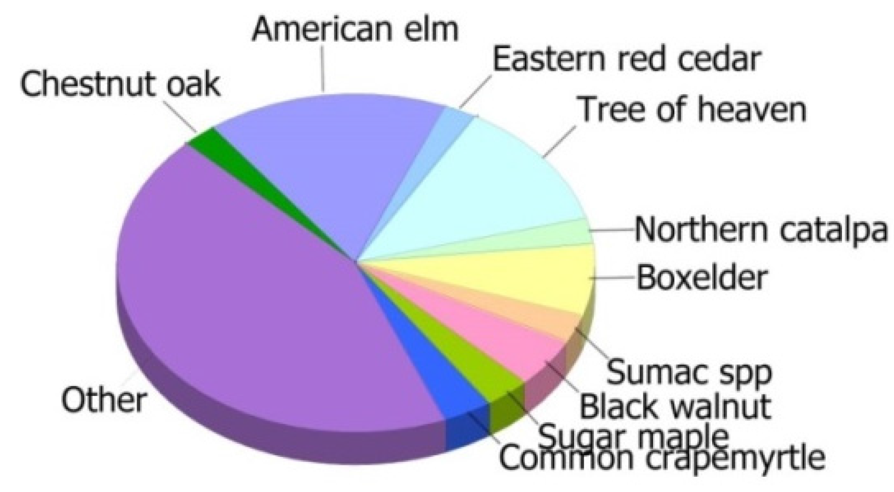
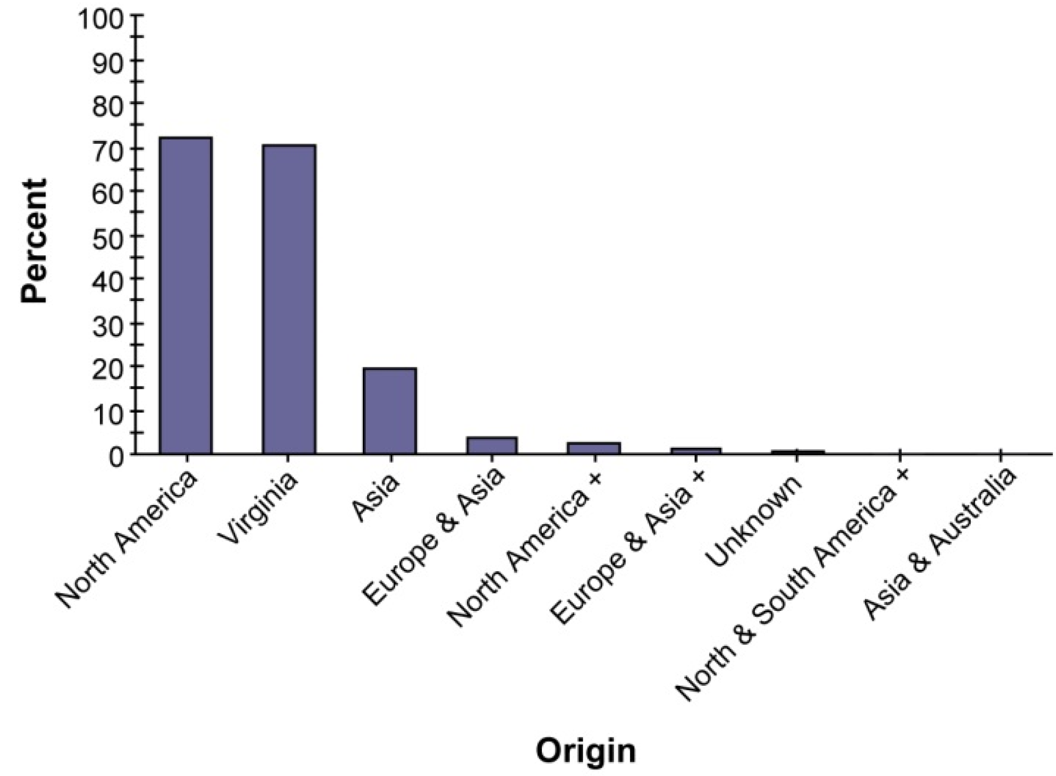
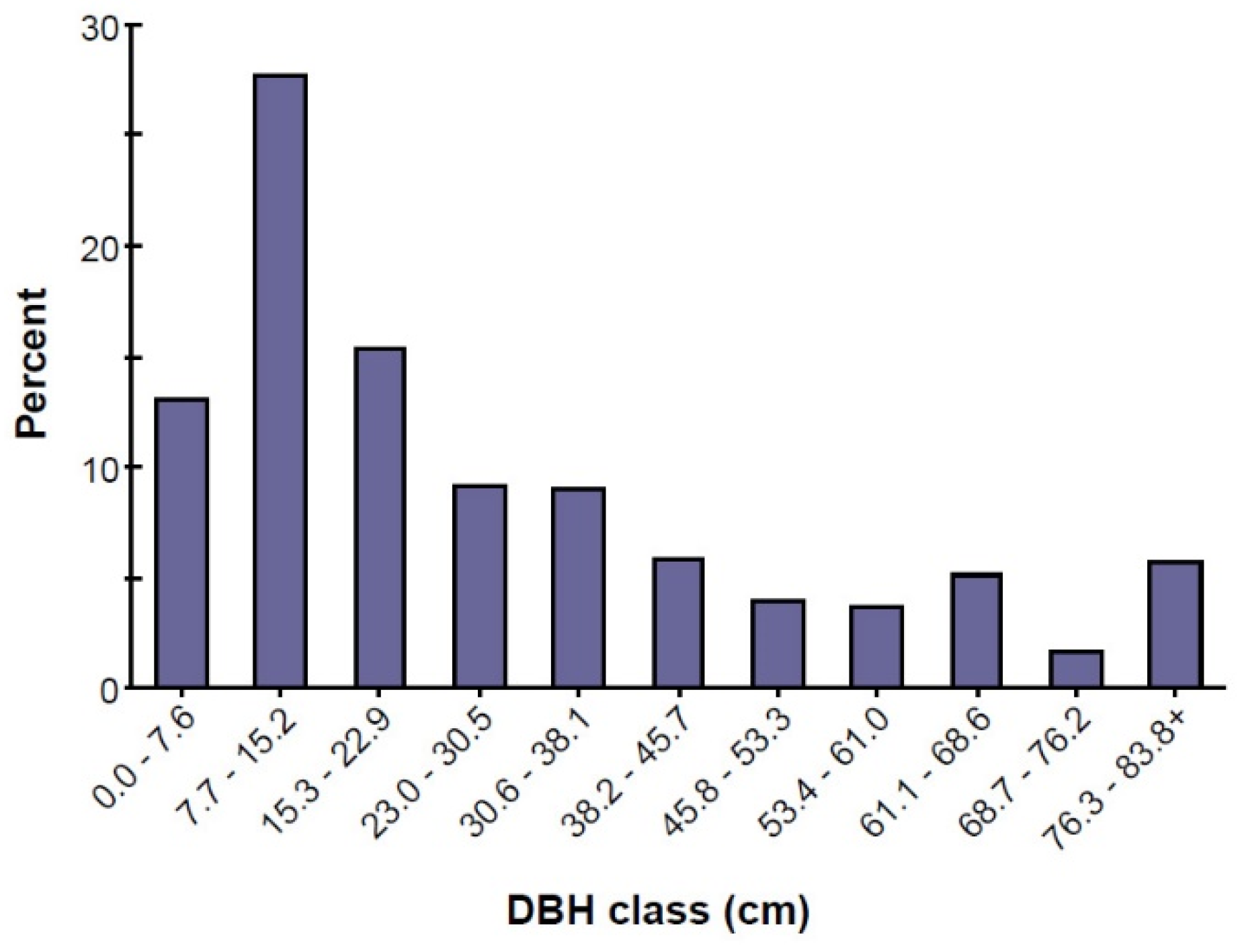
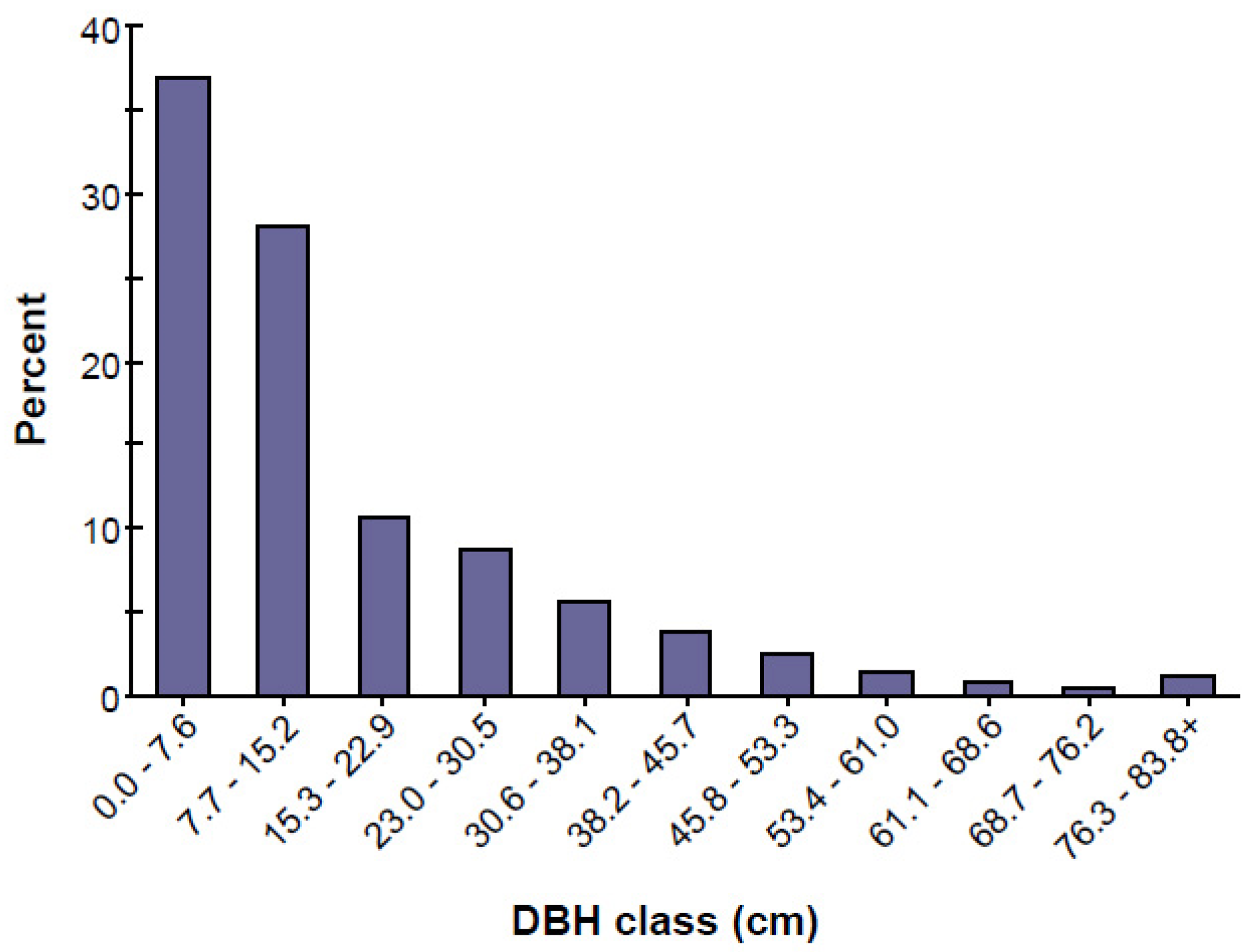
This model was used to assess green infrastructure structure, services and value of vacant land and residential land in Roanoke. Within each land use, randomly located 0.04 ha field plots were measured. Plot measurements include the percent of plot tree cover, shrub cover, plantable space, and ground cover types. Trees on each plot were also measured for total height, Diameter at Breast Height (DBH; 1.37 m from base of tree), crown width, percentage of canopy missing and dieback, crown light exposure, and distance and direction of trees to nearby buildings. A total of 197 plots were sampled across the two land use types: vacant land (114) and single family residential land (83). Plots on both public and private property were assessed. All field data were collected during the 2012, 2013 leaf-on season (June–July) to properly assess tree canopies. Field data were input to the i-Tree Eco model to assess forest structure and associated ecosystem services and values [15].
Air pollution removal estimates are derived from calculated hourly tree-canopy resistance for ozone, and sulfur and nitrogen dioxides based on a hybrid of the big-leaf and multi-layer canopy deposition models [16,17]. As the removal of carbon monoxide and particulate matter less than 10 microns by vegetation is not directly related to transpiration, removal rates (deposition velocities) for these pollutants are based on average measured values from the literature [18,19] and adjusted depending on leaf phenology and leaf area. Particulate removal incorporates a 50% re-suspension rate of particles back to the atmosphere [20]. The estimation of the pollution removal value of trees was based on field data and pollution and weather data (2011).
Tree store and sequester carbon dioxide through their growth process in their tissue. Carbon storage and carbon sequestration is estimated based on tree species, size and estimated growth rates. Carbon storage and carbon sequestration dollar values are calculated based on $78.5 per metric ton of carbon [21]. As trees die and decay, they release much of the carbon that they store.
Trees on urban vacant land affect energy consumption by shading buildings, providing evaporative cooling, and blocking winter winds, thus reducing building energy consumption in the summer months, either increasing or decreasing building energy use in the winter months, depending on the location of trees around the building. Estimates of tree effects on energy use are based on field measurements of tree distance and direction to space conditioned residential buildings [22]. Energy savings are converted to monetary savings based on state average energy costs.
Structural value of an urban forest is estimated based on valuation procedures of the Council of Tree and Landscape Appraisers [23], which uses information on three species, diameter, condition, and location [24]. Plantable space is not covered by impervious surfaces and is free of overhead obstructions such as existing tree canopies and utility lines [25]. The percentage of the area beneath the dripline of the tree that is impervious is used in runoff calculation.

3. Results

Urban vacant land has a different forest structure to single family residential land in terms of the number of trees, species composition, tree sizes, tree health, tree canopy cover, and ground cover types. As one would expect, the different urban forest structures on vacant land and residential land result in different ecosystem services.

3.1. Forest Structure of Roanoke’s Vacant and Residential Land

3.1.1. Tree Characteristics of Roanoke’s Vacant and Residential Land

Single family residential land had more trees (1,683,000) than vacant land (210,000) due in a large part to the differences in land area (32.4 km2 of vacant land vs. 57.9 km2 residential) (Table 1). While the percentage of tree coverage was almost identical between the land uses (30.6% in vacant to 32.3% in residential), the number of trees per ha is greater on residential land (290.3) than on vacant land (63.4).
Many tree benefits are directly proportional to the amount of healthy leaf surface area of the plant [25]. The average healthy leaf surface area on individual trees growing on vacant land is greater than that of individual trees on residential land, and thus individual trees on vacant land currently provide more ecosystem services to citizens on a per tree basis than those growing on residential land. The three most common species growing in vacant land are Ulmus americana (American elm) (16.4%), Ailanthus altissima (tree of heaven) (12.3%), and Acer negundo (box elder) (6.7%) (Figure 1). The three most common species in residential land are Ailanthus altissima (tree of heaven) (10.8%), Cornus florida (flowering dogwood) (10.0%), and Prunus serotina (black cherry) (9.3%) (Figure 2). The overall tree density on Roanoke’s vacant land is 63.4 trees per ha, which is lower than residential land (Table 1).
Urban forests are composed of a mix of native and exotic tree species, so they often have higher species diversity than surrounding native landscapes [25]. High species diversity helps minimize ecosystem vulnerability to species-specific pests and disorders, but may also pose a risk to ecosystem health if exotic species are invasive plants that can out-compete and displace native species [26]. Additionally, exotic species may also not provide the habitat needed to support native fauna. About 69% of the trees growing on Roanoke’s urban vacant land are species that are native to North America, and 60% are native to the state (Figure 3). Exotic species from outside North America make up 31% of the population. Most of Roanoke’s urban vacant land exotic tree species are indigenous to Asia (20.2% of the species). However, in Roanoke’s residential land, about 72% of the trees are species native to North America, while 71% are native to the state (Figure 4). Species exotic to North America make up 28% of the tree population (Figure 4). Most of Roanoke’s residential land exotic tree species are indigenous to Asia (19.3% of the species).
Vacant land forest structure has a slightly higher percentage of non-native tree species than residential land, which means that vacant land has proportionally more exotic species that are potentially invasive that can potentially out-compete and displace native species. Vacant lands host pioneer species through secondary succession, which can introduce non-native species over time. Residential land forest structure is dominated by higher tree species richness, and contains more native species. The number of tree species per ha is higher on residential land than vacant land, which is likely due to ornamental plantings in residential areas and limited regeneration on vacant land (Table 2).
Large trees generally provide more ecosystem services, such as improving air quality and public health, cooling the air, reducing demand for air conditioning, and supporting climate change adaptation, than smaller trees [27]. Although there are some large trees on vacant land, the larger number of smaller trees collectively plays an important role in providing ecosystem benefits. The trees growing on Roanoke’s vacant land with diameters less than 15.2 cm constitute 40.8% of the tree population (Figure 5), which suggests that these are relatively young trees and thus likely to be helpful in sustaining the urban ecosystem in Roanoke for years to come. While they are small today, they have the potential to increase in size over time. The trees growing on Roanoke’s residential land with diameters less than 15.2 cm constitute 65% of the tree population (Figure 6).
Both Roanoke’s residential and vacant land tree conditions are dominated by excellent, good, and fair conditions. The majority of trees on vacant land are in excellent, good, and fair condition (94%) based on the percentage of foliage dieback, which is slightly higher than residential land (86%) (Table 3). In addition, few dead trees (7.2%) are found. However, residential land has more excellent trees (69.7%) than vacant land does (9.5%), but also has few dead trees (7.2%) as well. Recent residential trees have an excellent condition. The residential forest structure contains a statistically significant higher number of tree species, higher total tree density, a narrower range of tree diameters and more dead trees. Some residential forest structure is not naturally occurring; rather, it is the result of residential planting that requires some particular characteristics. Residential trees would be better cared for and dead trees in residential areas are usually removed.

3.1.2. Urban Forest Cover on Roanoke’s Vacant and Residential Land

The two most dominant ground cover types in vacant land are grass (39.5%) and wild grass (24.8%) (Table 4). These two dominant ground cover types (64.3%) are permeable, which means that vacant land can be strategically used to control urban storm water. Greening vacant land can be an important storm water management strategy [28]. The three impervious ground cover classes (buildings, cement, and rock) make up 15.1% of the city’s total ground area (Table 4). The ground space available for tree planting is 59.2% of the urban vacant land and 29.2% of residential land, which suggests that urban vacant land has a high potential for increasing Roanoke’s tree canopy cover and associated ecosystem services. Among the categories of land use, the highest plantable space occurs on vacant land, followed by residential land (Table 4).

3.2. Ecosystem Services Provided by Roanoke’s Vacant and Residential Land

3.2.1. Air Pollution Removal Value by Vacant and Residential Land

As shown in Figure 7, ozone (O3) benefited from the greatest pollution removal value; 83 t (0.02 t per ha) of air pollutants (CO, NO2, O3, PM10, and SO2) is removed by trees on vacant land in Roanoke every year with a related value of $916,000 ($220.72 per ha), based on estimated national median externality costs associated with pollutants [29]. Roanoke residential land trees removed 211 t (0.03 t per ha) of air pollutants (CO, NO2, O3, PM10, and SO2) per year with an associated value of $5.55 million ($789 per ha) (Figure 8). Residential lands remove pollution as they have a greater amount (ha) of overall tree cover.

3.2.2. Carbon Storage and Sequestration

The gross sequestration of Roanoke’s urban vacant land trees is about 2090 t of carbon per year (Table 5), with an associated value of $164,000. Net carbon sequestration (accounting for losses from carbon dioxide release through tree respiration) in urban vacant land is estimated at about 1960 t annually (Table 5). The gross sequestration of residential land trees is about 13,600 t of carbon per year with an associated value of $1.1 million. Net carbon sequestration in residential land is about 9530 t annually (Table 5).
The overall tree density on vacant land in the city is 63.4 trees per ha, which is lower relative to residential land (230.4 per ha) (Table 6). However, the gross sequestration of Roanoke’s vacant land trees is about 630.7 kg of carbon per ha annually. Trees on urban vacant land are estimated to have accumulated 29,407 kg of carbon per ha, which is almost identical to residential (29,407–36,997) (Table 6).
As trees grow, they accumulate carbon and then when they die and decay, they release much of the stored carbon back to the atmosphere. Thus, carbon storage is an indication of the amount of carbon that can be lost if trees are allowed to die and decompose. Trees growing on urban vacant land in Roanoke are estimated to store 97,500 t of carbon, which is valued at $7.65 million, while trees in residential land store 220,000 t of carbon ($17.3 million). Of all the species sampled, Ulmus americana (American elm) stores and sequesters the most carbon based on the number of tree species (approximately 19.0% of the total carbon stored and 18.8% of all carbon sequestered trees growing on vacant land in the city) (Figure 9). Ailanthus altissima (tree of heaven) sequesters the most carbon (10.8% of all sequestered carbon on residential land in the city) (Figure 10).

3.2.3. Reduced Runoff

In Roanoke, urban vacant land has three impervious ground cover classes (buildings, cement, and rock), which make up 15.1% of the total ground cover (Table 4), which is relatively low compared to residential land (25.9%). The trees growing on Roanoke’s vacant land help to reduce runoff by an estimated 120,000 cubic meters a year, with an associated value of $283,000 (Table 7) [30]. Trees in residential land helped reduce runoff by an estimated 338,000 cubic meters a year with an associated value of $795 thousand (Table 7) [30].

3.2.4. Trees and Building Energy Use

Based on state-wide energy costs for Virginia ($106.1 per MWH and $12.26 per MBTU), the trees growing on urban vacant land in Roanoke reduced energy consumption for residential buildings by around $211,000 annually (Table 8 and Table 9). Trees on vacant land also reduced the amount of carbon released by fossil-fuel based power plants (a reduction of 358 t), with an associated value of $28,103 annually. Trees in Roanoke residential land are estimated to reduce energy-related costs by $497,000 annually and also reduce 814 t of carbon emissions with an associated value of $63,899.

3.2.5. Structural and Functional Values

The structural value of Roanoke’s vacant land trees is estimated at $169 million with a carbon storage value of $7.6 million. The annual functional values of Roanoke’s vacant land trees are: carbon sequestration ($164 thousand) (Table 10); pollution removal ($916 thousand); lower energy costs and carbon emission reduction ($239 thousand). The structural value of Roanoke’s residential land trees is $1.43 billion with a carbon storage value of $17.3 million. The annual functional values of Roanoke’s residential land trees are: carbon sequestration ($1.07 million/year); pollution removal ($5.55 million/year); lower energy costs and carbon emission reduction ($560.9 thousand/year). Trees on vacant urban land in Roanoke store 97,500 t of carbon (29,400 kg per ha) valued at $7.65 million ($22.932 per ha). These trees annual accumulate additional carbon of about 2090 t (630 kg per ha) valued at $164,000/year ($491.4/year per ha), which is high compared to residential land in the city. The trees on Roanoke’s vacant land also remove an estimated 83 t of air pollution annually (0.02 t per ha) valued at $916,000 ($220.72 per ha per year) (Table 11).

4. Discussion

A major driver of the type and quantity of ecosystem services in urban areas is land cover [31]. The land cover of vegetation and bare soil provide more provisioning services (e.g., food production, water supply), regulating services (e.g., climate regulation, air pollution removal), and supporting services (e.g., nutrient cycling, soil building) than non-vegetated and impervious surfaces [31,32]. Urban forest cover reduces the impact of impervious surfaces, such as roads, buildings, and to a lesser degree maintained grass. Impervious surfaces reduce water infiltration and increase runoff, affecting residential water quality. Trees and vegetation ground cover types reduce storm water impacts by intercepting rainfall, slowing water movement, and increasing absoprtion in the ground.
Vacant land forest structure can be a very cost-effective way of reducing the need for expensive storm water management infrastructure such as retention tanks and sewer systems [33]. Vegetation uses storm water as a resource, capturing a significant percentage of run off. The current forest structure on vacant land can help manage urban storm water to prevent residential floods and can also filter the polluted water running off cities’ impervious paving areas, such as parking lots and road systems, to renew clean ground water systems. Vacant land is thus an important component of urban green infrastructure systems that can significantly affect the health of the local urban ecosystem, providing enduring value for the community. Vacant land supports 59.2% of the plantable space, which is higher than residential land (29.2%) (Table 4). Vacant land is also 24.8% wild grass, which is again higher than residential land (1.8%). This means that vacant land can be strategically used as part of the urban green storm water infrastructure. Most vacant land consists of previously developed land that is now vacant with no structures, although some vacant sites contain a natural forest structure, which means that vacant land can be easily built upon and there are no environmental and physical constraints to redeveloping those spaces so they can be easily managed for redevelopment as green infrastructure, such as small parks, urban agriculture and community gardens, in the future. Vacant land therefore has a high potential value as green infrastructure that can be used to provide ecosystem services for city residents.
Climate change is a major issue around the world. Trees can remove carbon dioxide through photosynthesis in their tissue, which can help counteract climate change. Trees also alter energy consumption by reducing carbon dioxide emission from the fossil-fuels burned by power plants [34]. Trees on urban vacant land reduce the amount of carbon in the atmosphere by sequestering carbon in new growth every year. The amount of carbon annually sequestered increases with the size and health of the trees. Biomass is a renewable energy source that can either be used directly via combustion to produce heat, or indirectly after conversion to various forms of biofuel. Urban vacant land is a valuable ecological resource that can be an effective biomass energy resource and also reduce carbon dioxide in the atmosphere by capturing carbon in new growth every year in a city.
Surface runoff can be a cause for concern in many urban areas as it often increases pollution in streams, wetlands, rivers, lakes, and oceans. When it rains, some portion of the precipitation is intercepted by vegetation (trees and shrubs) while the remainder reaches the ground. The portion of the precipitation that reaches the ground and does not infiltrate into the soil becomes surface runoff [35]. In urban areas, the extensive area covered by impervious surfaces increases the amount of surface runoff. The plantable space available on the vacant land is about 59.2%, which is much higher than residential land (29.2%). Vacant land therefore has considerable potential to reduce surface runoff if planting of vacant lands is increased. Vacant land may be a valuable ecological resource that can be strategically used as urban green storm water infrastructure through urban forests, including trees, shrubs and pervious ground cover classes. For example, urban trees in Roanoke are highly beneficial in reducing surface runoff. Trees intercept precipitation, while their root systems promote infiltration and storage in the soil.
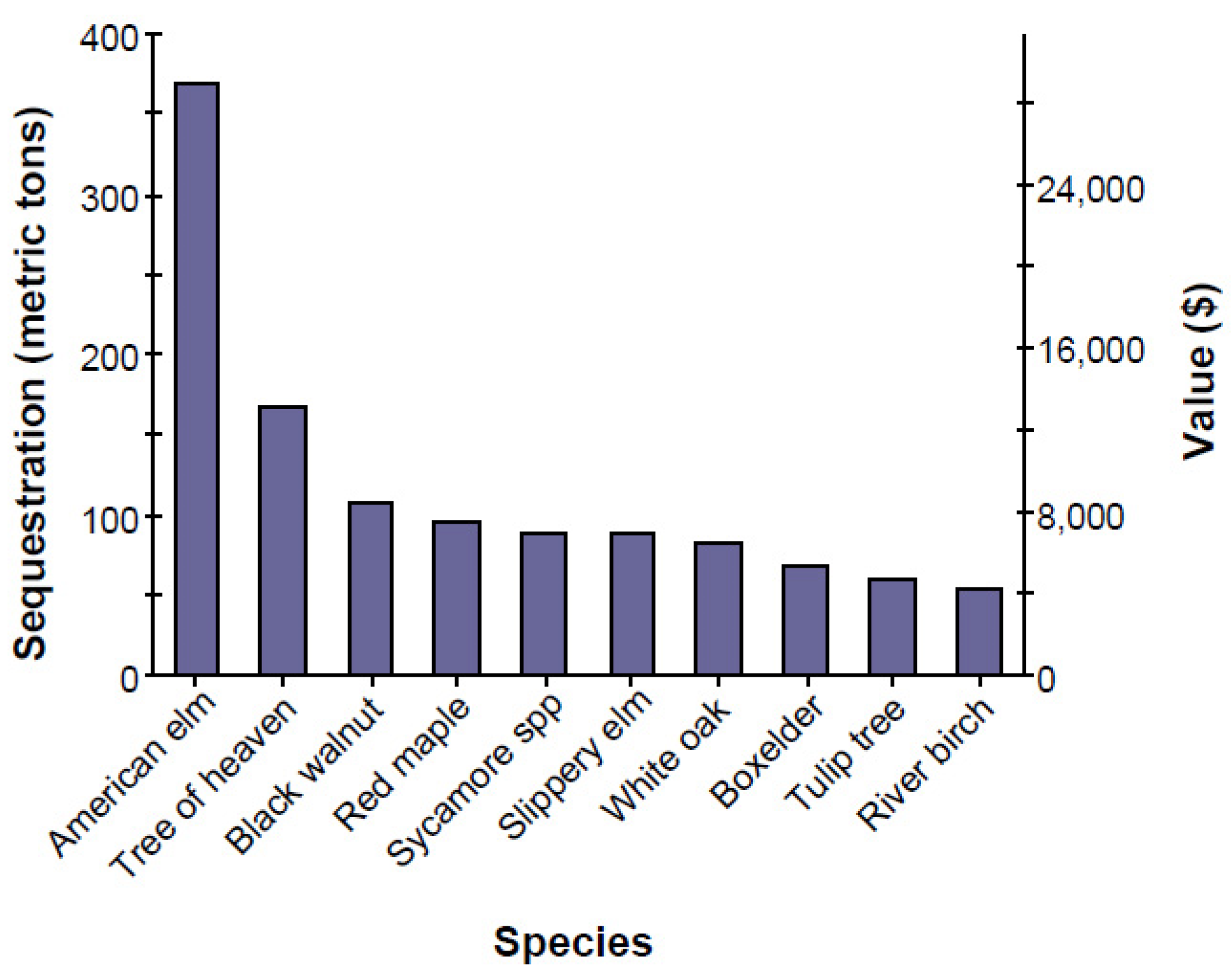
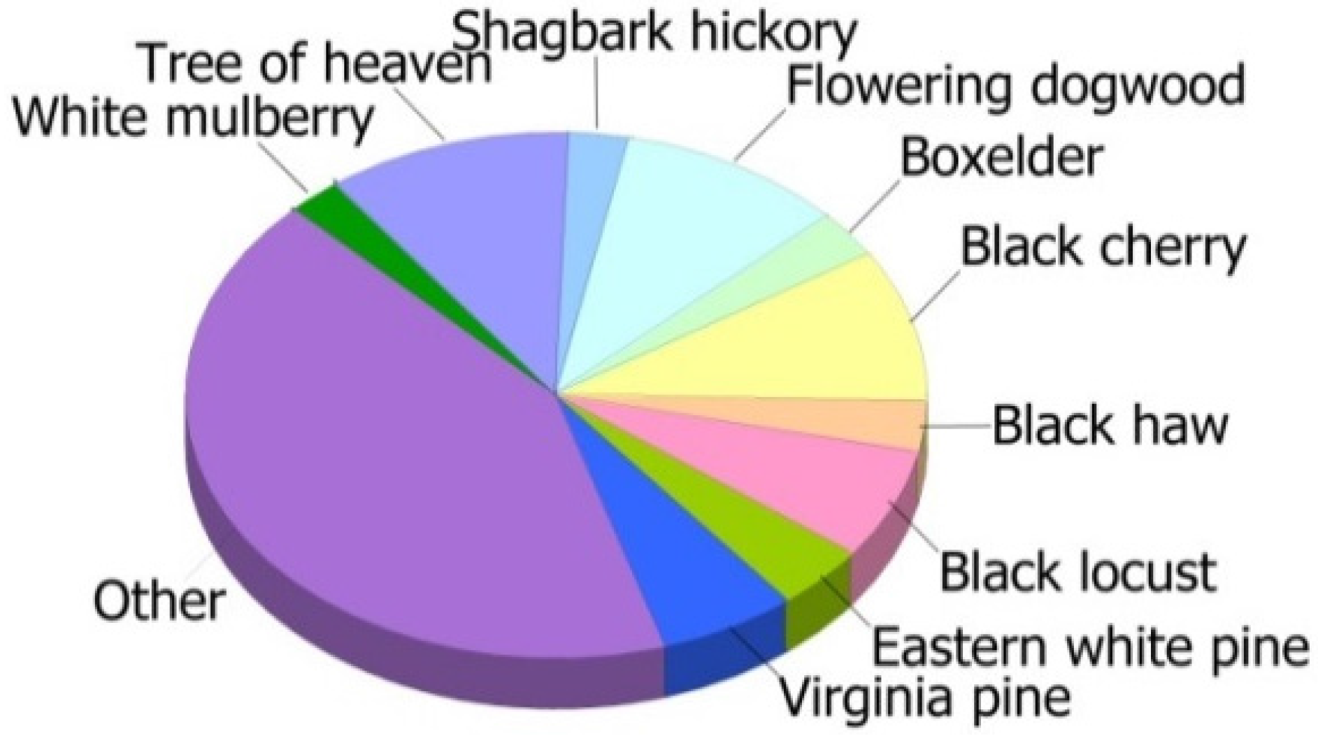
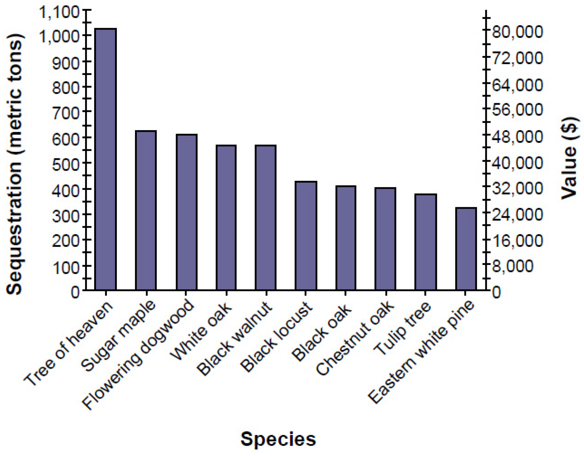
The results of the comparison of urban forests effects and values by land use suggest that residential land use offers the greatest current and potential future ecosystem benefits on a per ha basis. However, city totals for Roanoke’s carbon storage and carbon removal value in urban vacant land is high compared to residential land based on number of trees (210,263–1,682,518) (Table 10). Vacant land can thus be one of the most effective ecological resources providing ecosystem services in a city. Trees on urban vacant land that are growing in natural stand conditions have more large trees with low density and a higher percentage cover (Table 1) and, thus, more above-ground biomass (carbon storage) than open-grown trees located on residential land [5].
Many residential trees are intentionally planted, so longer life trees and low maintenance trees are needed to reduce the tree death level, and to reduce pollutant emissions from maintenance activities. Also, a planting plan of residential areas needs to consider the service provided by trees in conserving energy in locations near residences, as well in providing shade for parking lots, reducing pollution from power plants and reducing vehicular VOC pollution. When people select tree species for residential land, pollutant-sensitive species should be avoided, and plantings should include the use of evergreen trees to improve tree-health and remove year-round particulate matter.
The comparison of the effects and values of urban forest on vacant and residential land indicates that vacant land has a high potential value as green infrastructure for providing ecosystem services for the city. Vacant land can be strategically used for urban green storm water infrastructure in urban forests, including trees, shrubs and pervious ground cover classes. They can be easily managed for redevelopment as green infrastructure, such as small parks, urban agriculture and community gardens in the future. Vacant land is a valuable ecological resource that can be an effective biomass energy resource and reduce carbon dioxide in the atmosphere by capturing carbon in new growth that occurs every year in a city. These results suggest that vacant urban land is a vital resource and a useful component of the city’s green infrastructure that provides significant benefits and should therefore be managed so as to increase its effectiveness and minimize any negative effects. The results of the comparison of urban forest effects and values on vacant and residential land suggest that the high ecosystem values of vacant sites should be protected, although these sites could be developed for a variety of uses if done in a manner that protects their current ecosystem values. Less sensitive vacant sites that have low ecosystem values could be developed for many different types of land use (e.g., housing, commercial, industry and green re-use options) as they have the most potential for improvement and increase in ecosystem benefits. Those vacant sites with historical significance that have remediation potential could be developed in a manner that preserves their historical value with a historically appropriate use. If other vacant sites have low ecosystem values and are not threatened by development, their current low ecosystem values have the potential to be enhanced through proper management.

5. Conclusions

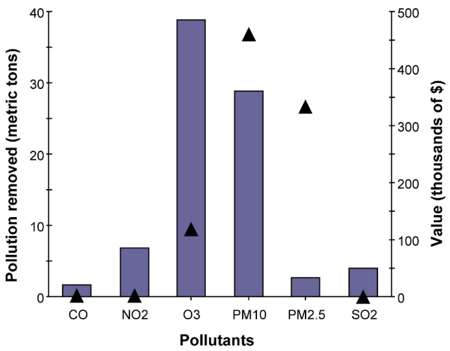
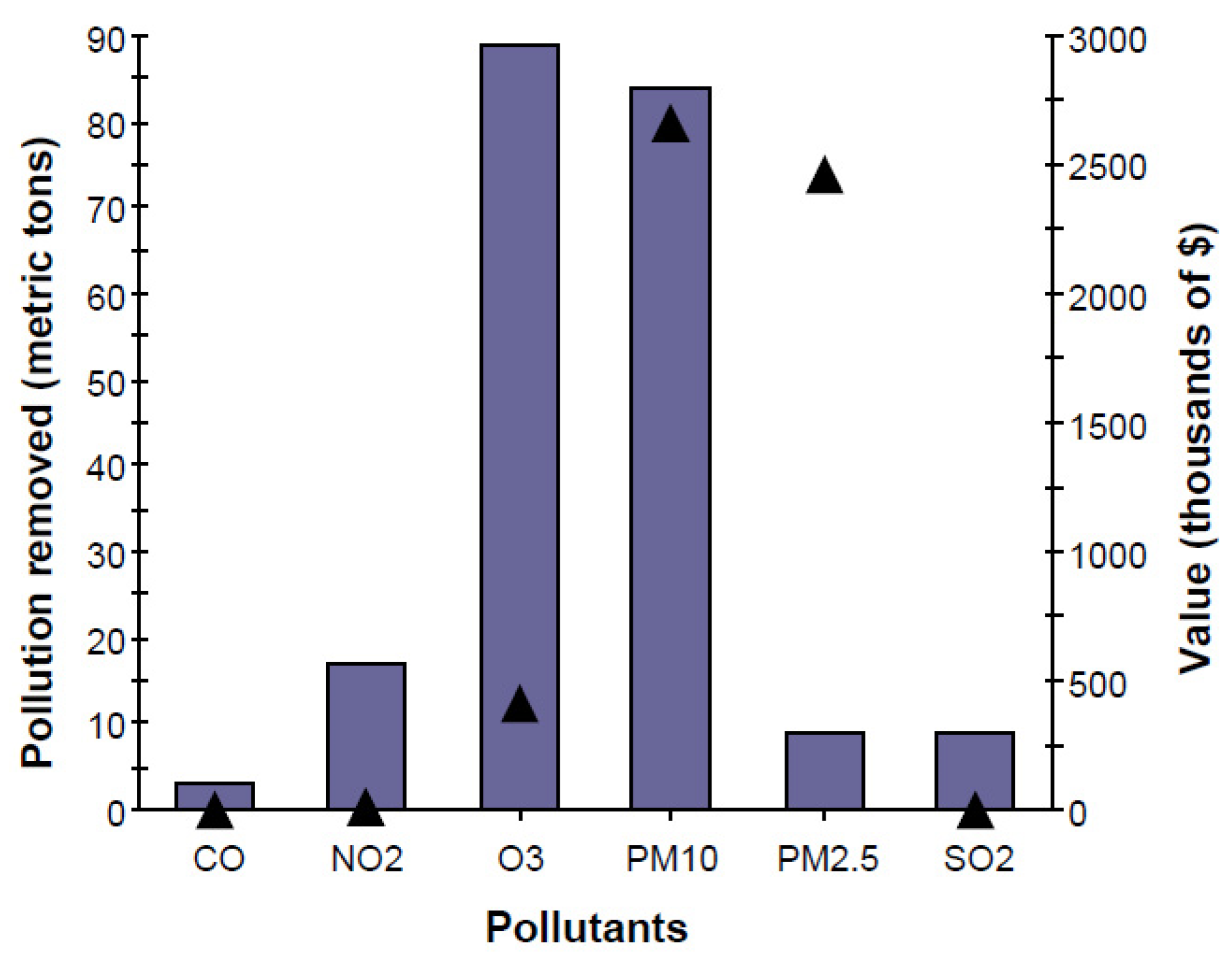
The purpose of assessing vacant and residential land forest structure and ecosystem services in this study was to demonstrate how vacant urban land functions as green infrastructure that provides ecosystem services and value to society. Understanding an urban forest’s structure, function and value can promote decision-making that will improve human health and environmental quality. The ecosystem services identified in the vacant land study in this paper captured the current structure of Roanoke’s urban forest growing on vacant land and quantified a subset of the ecosystem functions and economic values it provides to Roanoke’s residents. Trees on vacant urban land in Roanoke store 97,500 t of carbon (29,400 kg per ha) valued at $7.65 million ($22.932 per ha). These trees annual accumulate additional carbon of about 2090 t (630 kg per ha) valued at $164,000/year ($491.4/year per ha), which is high compared to residential land in the city. The trees on Roanoke’s vacant land also remove an estimated 83 t of air pollution annually (0.02 t per ha) valued at $916,000 ($220.72 per ha per year). These trees also reduce energy-related costs from residential buildings by about $211,000 annually, and additionally reduce power plant carbon emissions valued at $28,103 (358 t).
The ecosystem services provided by Roanoke’s urban vacant land were analyzed using the i-Tree Eco model, which facilitates the creation of ecological design guidelines for future development. Although these spaces are now beginning to receive more attention, as yet there are no strategic plans for utilizing them more effectively. The ecosystem services provided by the vacant land in the City of Roanoke, Virginia, described in this study suggest new ways to reinvigorate or revitalize these spaces in terms of their ecological value. An analysis of the structure, function, and economic benefits of urban vacant land can be a useful reference for local authorities, landowners and regeneration professionals, as well as providing a rationale for a change in current approaches towards potentially valuable urban vacant land. The overall aim in the study is to advance knowledge about the value of vacant land within an urban landscape. These places may offer alternative, creative ways to envision urban open space and landscape design in a city. Urban vacant land will be redefined as a valuable resource when considered from a different perspective as a potential redevelopment. This can have important implications for policy development allowing practitioners to better understand urban vacant spaces, and can lead to better utilization of these spaces.

Acknowledgments

The open access publishing fees for this article have been covered by the Virginia Tech’s Open Access Subvention Fund (OASF), supported by the University Libraries. This research was supported by funds through the APS Endowment for Sustainable Design Research Fund (Arizona State University, Herberger Institute for Design and the Arts).

Author Contributions

All authors have contributed to the idea of the paper. Gunwoo Kim developed research design, analyzed the data and wrote the manuscript. Patrick Miller provided some core advice and checked through the whole paper. David Nowak consulted on analysis methods and study design, and on review of data and paper. The authors have read and approved the final manuscript.

Conflicts of Interest

The authors declare no conflict of interest.

References

  1. Pagano, M.A.; Bowman, A.O.M. Vacant Land in Cities: An Urban Resource; Brookings Institution, Center on Urban and Metropolitan Policy: Washington, DC, USA, 2000. [Google Scholar]
  2. U.S. Government Accountability Office. Vacant Properties: Growing Number Increases Communities’ Cost and Challenge. 2011. Available online: http://www.gao.gov/assets/590/586089.pdf (accessed on 5 January 2015). [Google Scholar]
  3. Burkholder, S. The new ecology of vacancy: Rethinking land use in shrinking cities. Sustainability 2012, 4, 1154–1172. [Google Scholar] [CrossRef]
  4. Németh, J.; Langhorst, J. Rethinking urban transformation: Temporary uses for vacant land. Cities 2014, 40, 143–150. [Google Scholar] [CrossRef]
  5. Kim, G.; Miller, P.A.; Nowak, D.J. Assessing urban vacant land ecosystem services: Urban vacant land as green infrastructure in the City of Roanoke, Virginia. Urban For. Urban Green. 2015, 14, 519–526. [Google Scholar] [CrossRef]
  6. Kamvasinou, K. The public value of vacant urban land. Munic. Eng. 2011, 164, 157–166. [Google Scholar] [CrossRef]
  7. Yadav, P.; Duckworth, K.; Grewal, P.S. Habitat structure influences below ground biocontrol services: A comparison between urban gardens and vacant lands. Landsc. Urban Plan. 2012, 104, 238–244. [Google Scholar] [CrossRef]
  8. Grewal, S.S.; Cheng, Z.; Masih, S.; Wolboldt, M.; Huda, N.; Knight, A.; Grewal, P.S. An assessment of soil nematode food webs and nutrient pools in community gardens and vacant lands in two post-industrial American cities. Urban Ecosyst. 2011, 14, 181–194. [Google Scholar] [CrossRef]
  9. Zipperer, W.C.; Pickett, S.T. Urban Ecology: Patterns of Population Growth and Ecological Effects; John Wiley & Sons, Ltd.: Chichester, UK, 2012. [Google Scholar]
  10. United States Environmental Protection Agency. Green Infrastructure. Available online: http://cfpub.epa.gov/npdes/home.cfm?program_id=298 (accessed on 21 March 2016).
  11. Nowak, D.J.; Rowntree, R.A.; McPherson, E.G.; Sisinni, S.M.; Kerkmann, E.R.; Stevens, J.C. Measuring and analyzing urban tree cover. Landsc. Urban Plan. 1996, 36, 49–57. [Google Scholar] [CrossRef]
  12. Nowak, D.J.; Crane, D.E. The Urban Forest Effects (UFORE) Model: Quantifying urban forest structure and functions. In Integrated Tools for Natural Resource Inventories in the 21st Century; US Department of Agriculture, Forest Service, North Central Research Station: St. Paul, MN, USA, 2000. [Google Scholar]
  13. Nowak, D.J.; Crane, D.E.; Stevens, J.C.; Hoehn, R.E. The Urban Forest Effects (UFORE) Model: Field Data Collection Manual V1b; US Department of Agriculture, Forest Service, Northeastern Research Station: Newtown Square, PA, USA, 2003.
  14. Nowak, D.; Hoehn, R.; Crane, D.; Weller, L.; Davila, A. Assessing Urban Forest Effects and Values, Los Angeles’ Urban Forest; Resour. Bull. NRS-47; US Department of Agriculture, Forest Service, Northern Research Station: Newtown Square, PA, USA, 2011; p. 30.
  15. Nowak, D.J.; Crane, D.E.; Stevens, J.C.; Hoehn, R.E.; Walton, J.T.; Bond, J. A Ground-Based Method of Assessing Urban Forest Structure and Ecosystem Services. Arboric. Urban For. 2008, 34, 347–358. [Google Scholar]
  16. Baldocchi, D. A multi-layer model for estimating sulfur dioxide deposition to a deciduous oak forest canopy. Atmos. Environ. (1967) 1988, 22, 869–884. [Google Scholar] [CrossRef]
  17. Baldocchi, D.D.; Hicks, B.B.; Camara, P. A canopy stomatal resistance model for gaseous deposition to vegetated surfaces. Atmos. Environ. (1967) 1987, 21, 91–101. [Google Scholar] [CrossRef]
  18. Bidwell, R.G.S.; Fraser, D.E. Carbon monoxide uptake and metabolism by leaves. Can. J. Bot. 1972, 50, 1435–1439. [Google Scholar] [CrossRef]
  19. Lovett, G.M. Atmospheric deposition of nutrients and pollutants in North America: An ecological perspective. Ecol. Appl. 1994, 4, 630–650. [Google Scholar] [CrossRef]
  20. Zinke, P.J. Forest interception studies in the United States. In Forest Hydrology; Sopper, W.E., Lull, H.W., Eds.; Pergamon Press: Oxford, UK, 1967; pp. 137–161. [Google Scholar]
  21. Interagency Working Group on Social Cost of Carbon United States Government. Technical Support. Document: Social Cost of Carbon for Regulatory Impact Analysis Under Executive Order 128666. 2010. Available online: http://www.epa.gov/oms/climate/regulations/scc-tsd.pdf (accessed on 21 March 2016). [Google Scholar]
  22. McPherson, E.G.; Simpson, J.R. Carbon Dioxide Reduction Through Urban Forestry; Gen. Tech. Rep. PSW-171; Pacific Southwest Research Station: Albany, CA, USA, 1999. [Google Scholar]
  23. Council of Tree and Landscape Appraisers. Guide for Plant Appraisal; International Society of Arboriculture: Urbana, IL, USA, 1992. [Google Scholar]
  24. Nowak, D.J.; Crane, D.E.; Stevens, J.C.; Ibarra, M. Brooklyn’s Urban Forest; Citeseer: University Park, PA, USA, 2002; Volume 290. [Google Scholar]
  25. Wiseman, E.; King, J. i-Tree Ecosystem Analysis Roanoke; USDA Forest Service Northern Research Station, Trans.; College of Natural Resources and Environment: Blacksburg, VA, USA, 2012; p. 27. [Google Scholar]
  26. Shah, A. Why is Biodiversity Important? Who Cares? Available online: http://www.globalissues.org/article/170/why-is-biodiversity-important-who-cares (accessed on 12 September 2013).
  27. Rosenthal, J.K.; Crauderueff, R.; Carter, M. Urban Heat Island Mitigation Can Improve New York City’s Environment; Sustainable South Bronx: New York, NY, USA, 2008. [Google Scholar]
  28. Crauderueff, R.; Margolis, S.; Tanikawa, S. Greening Vacant Lots: Planning and Implementation Strategies; The Nature Conservancy: New York, NY, USA, 2012. [Google Scholar]
  29. Murray, F.J.; Marsh, L.; Bradford, P.A. New York State Energy Plan, Vol. II: Issue Reports; New York State Energy Office: Albany, NY, USA, 1994. [Google Scholar]
  30. U.S. Forest Service Tree Guides. Available online: http://www.fs.fed.us/psw/programs/used/uep/tree_guides.php (accessed on 21 March 2016).
  31. Kremer, P.; Hamstead, Z.A.; McPhearson, T. A social-ecological assessment of vacant lots in New York City. Landsc. Urban Plan. 2013, 120, 218–233. [Google Scholar] [CrossRef]
  32. Millennium Ecosystem Assessment. Ecosystems and Human Well-Being: Synthesis; Island Press: Washington, DC, USA, 2005. [Google Scholar]
  33. Grumbles, B. Memorandum: Using Green Infrastructure To Protect Water Quality in Stormwater, CSO, Nonpoint Source and Other Water Programs. United States Environmental Protection Agency, Office of Water, 2007. Available online: http://water.epa.gov/reg3wapd/npdes/pdf/dcms4_guidance.pdf (accessed on 21 March 2016). [Google Scholar]
  34. Abdollahi, K.K.; Ning, Z.H.; Appeaning, A.; Gulf Coast Regional Climate Change Council. Global Climate Change & the Urban Forest; Franklin Press: Baton Rouge, LA, USA, 2000. [Google Scholar]
  35. Hirabayashi, S.; Kroll, C.N.; Nowak, D.J. i-Tree Eco Dry Deposition Model Descriptions. 2015. Available online: https://www.itreetools.org/eco/resources/iTree_Eco_Dry_Deposition_Model_Descriptions.pdf (accessed on 22 March 2016).
Figure 1. Tree species composition in urban vacant land, City of Roanoke, Virginia.
Sustainability 08 00296 g001
Figure 2. Tree species composition in residential land, City of Roanoke, Virginia.
Sustainability 08 00296 g002
Figure 3. Species composition of live trees in urban vacant land, City of Roanoke by geographic origin.
Sustainability 08 00296 g003
Figure 4. Species composition of live trees in residential land, City of Roanoke by geographic origin.
Sustainability 08 00296 g004
Figure 5. Vacant land percentage of tree population by diameter class (DBH = stem diameter at 1.37 m above ground line).
Sustainability 08 00296 g005
Figure 6. Residential land percentage of tree population by diameter class (DBH = stem diameter at 1.37 m above ground line).
Sustainability 08 00296 g006
Figure 7. Pollution removal (bars) and associated economic value (line) for trees in vacant land, City of Roanoke, Virginia.
Sustainability 08 00296 g007
Figure 8. Pollution removal (bars) and associated economic value (line) for trees in residential land, City of Roanoke, Virginia.
Sustainability 08 00296 g008
Figure 9. Carbon sequestration and value for species with greatest overall carbon sequestration in Roanoke vacant land.
Sustainability 08 00296 g009
Figure 10. Carbon sequestration and value for species with greatest overall carbon sequestration in Roanoke residential land.
Sustainability 08 00296 g010
Table 1. Comparison of urban forests: Percentage tree cover and number of trees by land use; summary data are provided from the City of Roanoke analyzed using the i-Tree Eco model.
Land UseKm²Percentage Tree Cover (SE)Number of Trees (SE)Number of Trees per ha (SE)
Vacant32.430.6 (2.5)210,263 (23,979)63.4 (7.2)
Residential57.932.3 (3.6)1,682,518 (246,867)290.3 (42.5)
SE = Standard error of total.
Table 2. Comparison of urban forests: City totals for trees’ biodiversity by land use; summary data are provided from the City of Roanoke analyzed using the i-Tree Eco model.
Land UseNumber of Tree Species (Percentage)Number of Native Species (Percentage)Number of Non-Native Species (Percentage)
Vacant62 (0.029%)43 (69%)19 (31%)
Residential90 (0.005%)65 (72%)25 (28%)
SE = Standard error of total.
Table 3. Comparison of urban forests: Percentage of tree condition in Roanoke by land use; summary data are provided from the city of Roanoke analyzed using the i-Tree Eco model.
Land UseExcellentGoodFairPoorCriticalDyingDead
Vacant9.5%45.7%38.9%5.9%0%0%0%
Residential69.7%6.9%9.7%5.5%0.8%0.2%7.2%
Table 4. Comparison of urban forests: City totals for percentage of coverage by land use; summary data are provided from the City of Roanoke analyzed using the i-Tree Eco model.
Ground Cover
Land UsePlant SpaceCementBare SoilRockDuff/MulchHerbsGrassWild GrassWaterBuildingTree
Vacant59.23.45.08.84.410.539.524.80.72.930.6
Residential29.217.20.51.427.83.640.11.80.37.331.4
Ground cover totals 100% and includes cement, bare soil, rock, duff/mulch, herbs, grass, wild grass, water, and buildings. Plant space and tree cover overlap with ground cover.
Table 5. Comparison of urban forests: City totals for tree effects by land use; summary data are provided from the City of Roanoke analyzed using the i-Tree Eco model.
Land UsePercent Tree Cover (SE)Number of Trees (SE)Carbon Storage (t) (SE)Gross Carbon Sequestration (t/year) (SE)Net Carbon Sequestration (t/year) (SE)
Vacant30.6 (2.5)210,263 (23,979)97,508 (16,274)2091 (287)1959.9 (266.9)
Residential32.3 (3.59)1,682,518 (246,867)224,089 (28,439)13,607 (1684)9554.7 (1787.5)
SE = Standard error of total.
Table 6. Comparison of urban forests: per-ha values of tree effects by land use; summary data are provided from the City of Roanoke analyzed using the i-Tree Eco model.
Land UseNumber of Trees per ha (SE)Carbon Storage (kg/ha) (SE)Carbon Sequestration (kg/year/ha) (SE)
Vacant63.4 (7.2)29,407 (4908)630.7 (86.7)
Residential290.3 (42.5)36,997 (4735)2279.0 (290.5)
SE = Standard error of total.
Table 7. Comparison of urban forests: City totals for avoided runoff for trees in urban vacant land and residential land; summary data are provided from the City of Roanoke analyzed using the i-Tree Eco model.
Land UseNumber of Trees (SE)Leaf Area (km2) (SE)Avoided Runoff (m3/year)Avoided Runoff Value ($)
Vacant land210,263 (23,979)39.90 (5.10)120,498.56283,307.93
Residential land1,682,518 (246,867)144.50 (19.90)338,096.28794,908.74
SE = Standard error of total Avoided runoff is calculated by the price $2351/m3.
Table 8. Annual energy conservation and carbon avoidance due to trees on urban vacant land near residential buildings in the City of Roanoke, Virginia (note: negative numbers indicate an increased energy use or carbon emission); summary data are provided from the City of Roanoke analyzed using the i-Tree Eco model.
Land UseResidentialVacantResidentialVacantResidentialVacant
Energy savingHeatingCoolingTotal
MBTU ¹84302127n/an/a84302127
MWH ²150413559170537091746
Carbon avoided (mt ³)15737757321914358
¹ One million British Thermal Units; ² Megawatt-hour; ³ Metric ton.
Table 9. Annual savings ¹ ($) in residential energy expenditure during heating and cooling seasons (note: negative numbers indicate a cost due to increased energy use or carbon emission); summary data are provided from the City of Roanoke analyzed using the i-Tree Eco model.
Land useResidentialVacantResidentialVacantResidentialVacant
Energy savingHeatingCoolingTotal
MBTU ¹103,35126,077n/an/a103,35126,077
MWH ²15,9154350377,610180,901393,525185,251
Carbon avoided (mt ³)11,383290552,51725,19963,89928,103
¹ Based on state-wide energy costs for Virginia—the prices of $106.1 per MWH and $12.26 per MBTU;² One million British Thermal Units; ³ Megawatt-hour.
Table 10. Comparison of urban forests: City totals for trees’ structural and functional value by land use; summary data are provided from the City of Roanoke analyzed using the i-Tree Eco model.
Land UseNumber of Trees (SE)Carbon Storage (t) (SE)Carbon Storage Value (US$) (SE)Carbon Sequestration (t/year) (SE)Carbon Removal Value (US$) (SE)Structural Value (US$) (SE)
Vacant210,263 (23,979)97,508 (16,274)7,605,624 (1,269,372)2091 (287)163,098 (22,386)168,911,300 (24,340,915)
Residential1,682,518 (246,867)224,089 (28,439)16,698,942 (2,140,242)13,607 (1684)1,030,146 (131,352)1,397,770,766 (177,354,411)
SE = Standard error of total.
Table 11. Comparison of urban forests: per-ha values of trees’ structural and functional value by land use; summary data are provided from the City of Roanoke analyzed using the i-Tree Eco model.
Land UseNumber of Trees per ha (SE)Carbon Storage (kg/ha) (SE)Carbon Storage Value (US$) per ha (SE)Carbon Sequestration (kg/year/ha) (SE)Carbon Removal Value (US$) per ha (SE)Structural Value (US$) per ha (SE)
Vacant63.4 (7.2)29,407 (4908)2293.7 (382.8)630.7 (86.7)49.2 (6.7)50,943 (7341)
Residential290.3 (42.5)36,997 (4735)2885.8 (369.3)2279.0 (290.5)177.8 (22.6)241,202 (30,605)
SE = Standard error of total.

