
Using a VGI and GIS-Based Multicriteria Approach for Assessing the Potential of Rural Tourism in Extremadura (Spain)


Abstract
:1. Introduction
2. Materials and Methods
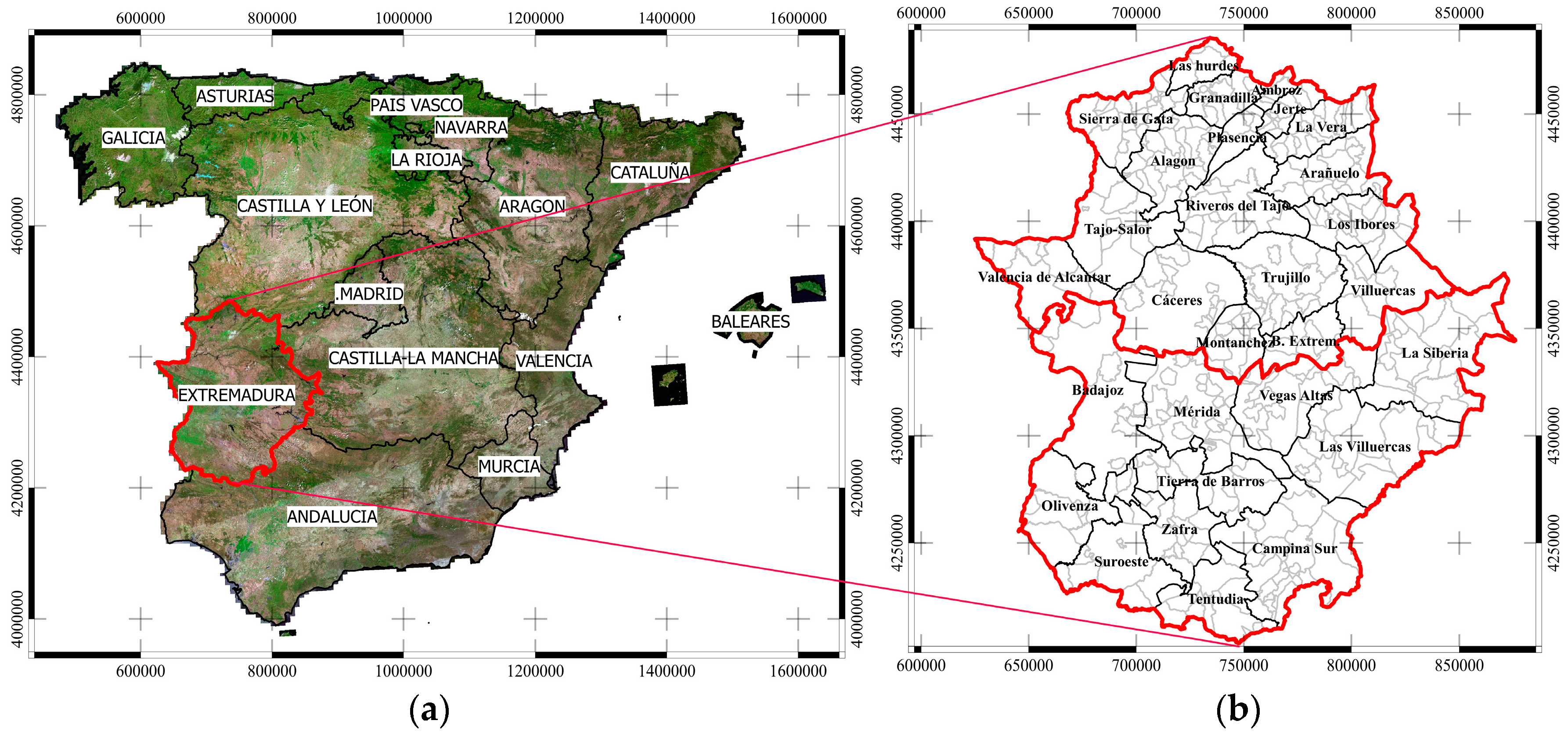
2.1. Study Area
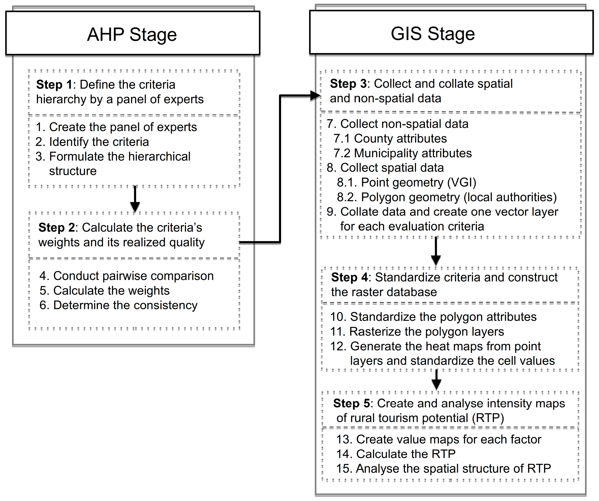
2.2. Methodology
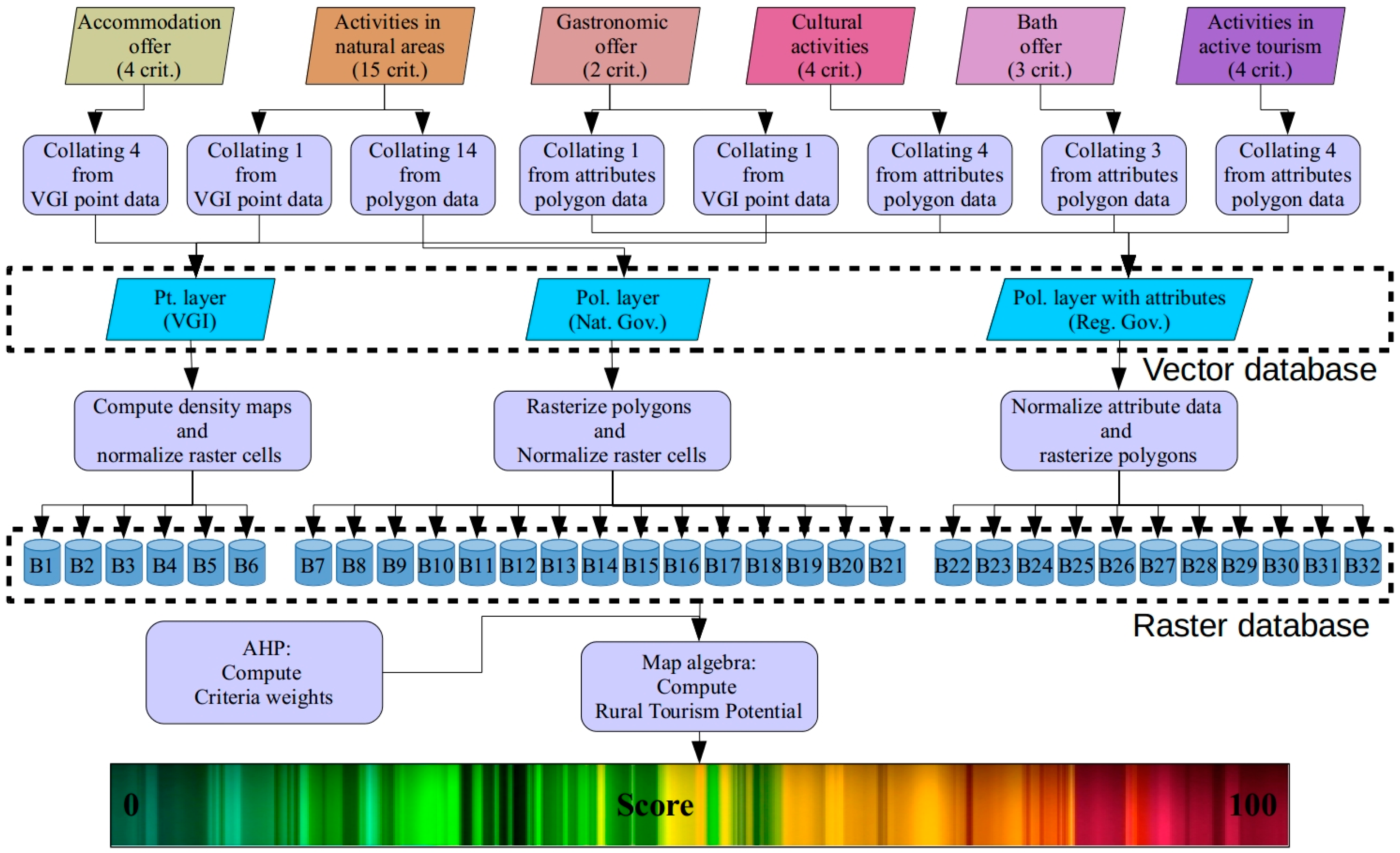
2.2.1. Design and Establishment of the Evaluation Model
2.2.2. Weighting of Evaluation Factors and Criteria
2.2.3. Data Collection and Collation
2.2.4. Selection of the Evaluation Unit
2.2.5. Standardization of Evaluation Criteria
2.2.6. Assessing the Potential of Rural Tourism
3. Results and Discussion
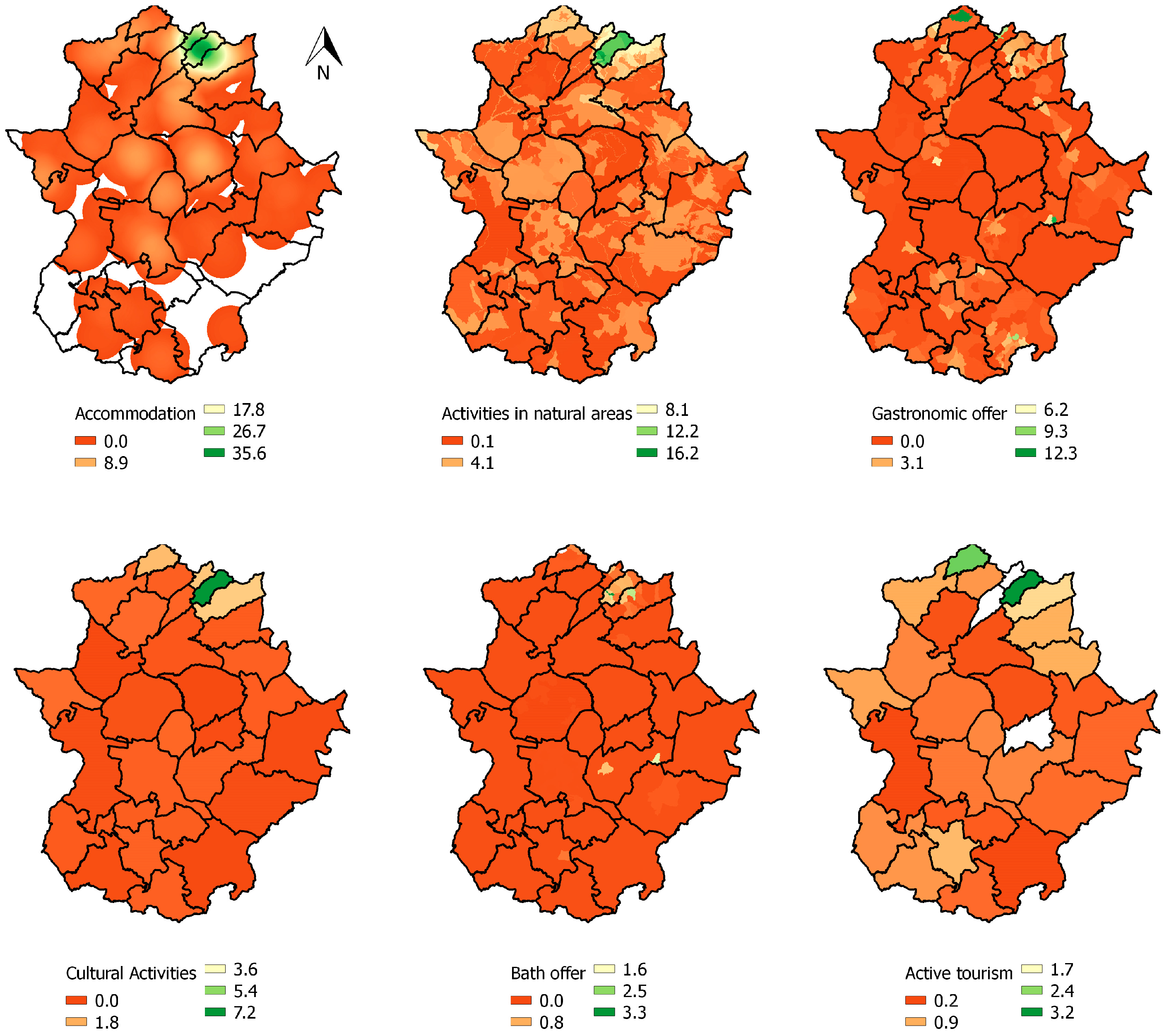
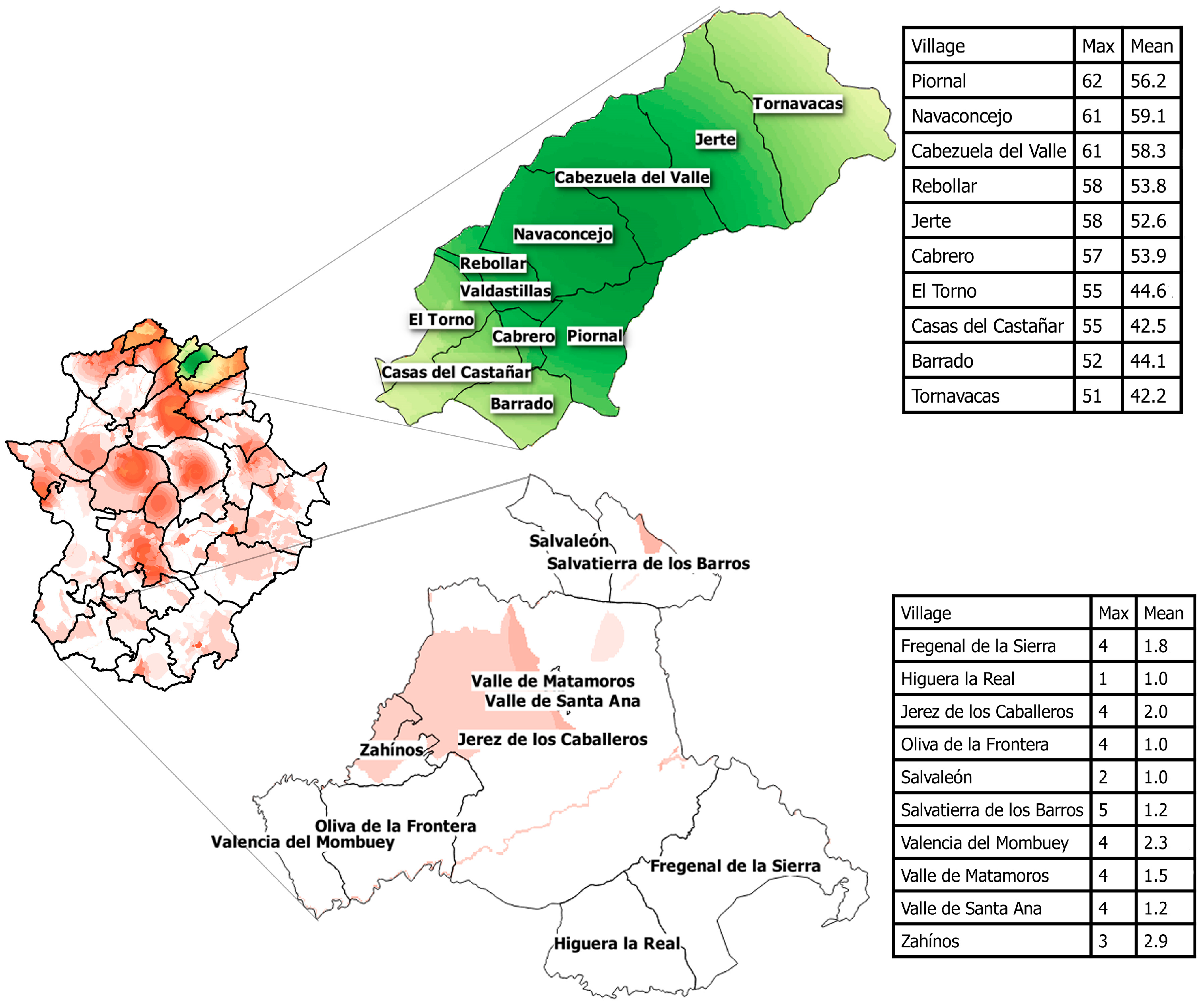
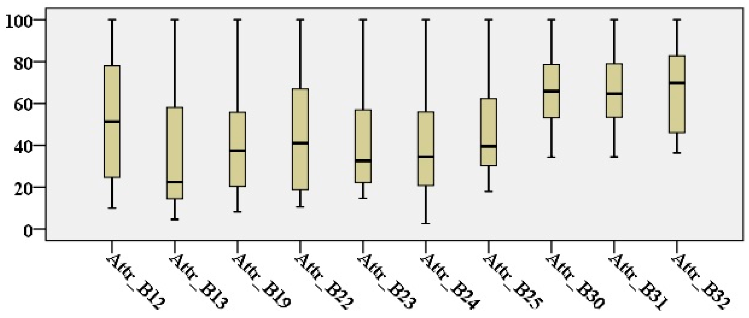
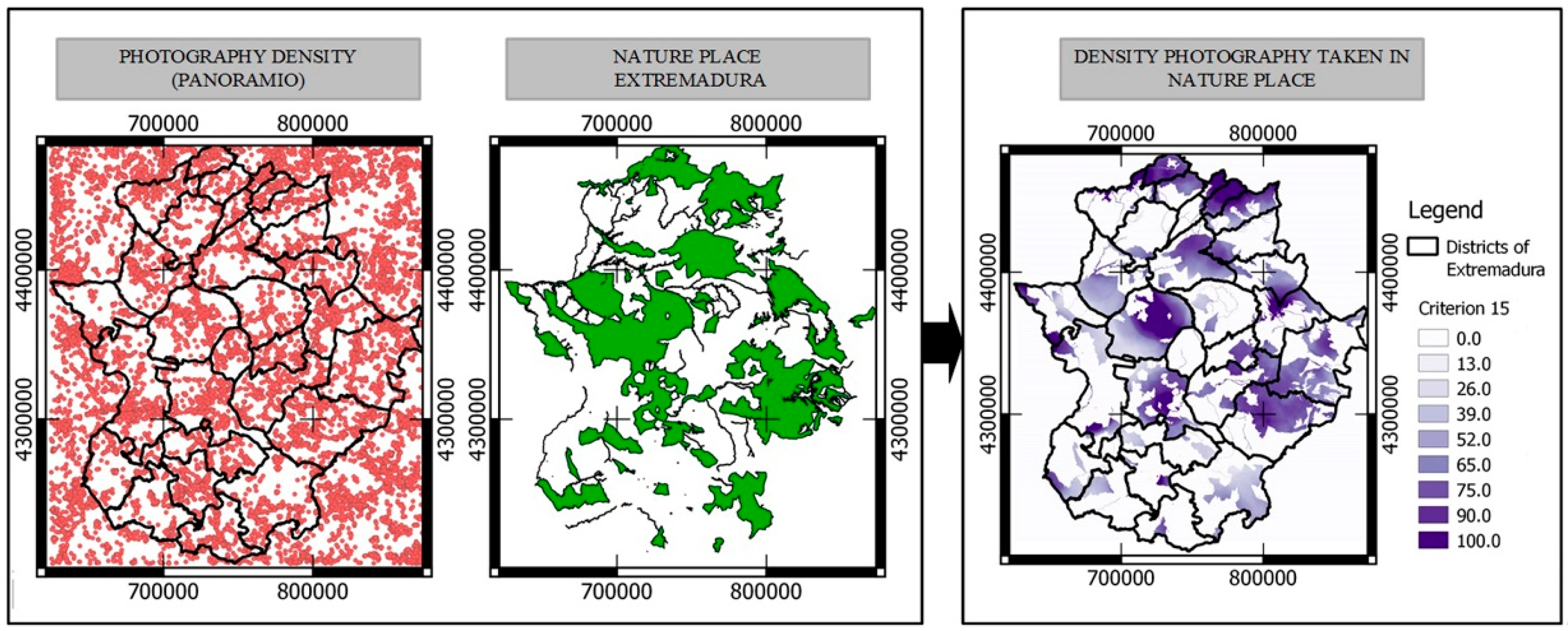
3.1. Analysis of the Evaluation Factors
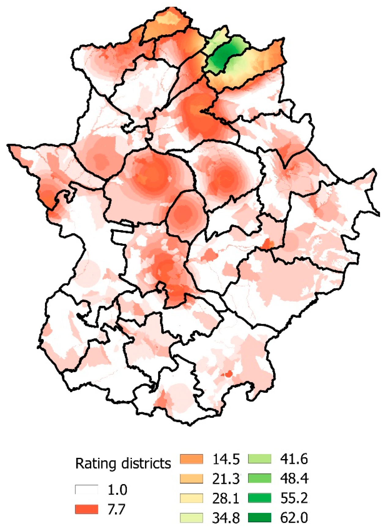
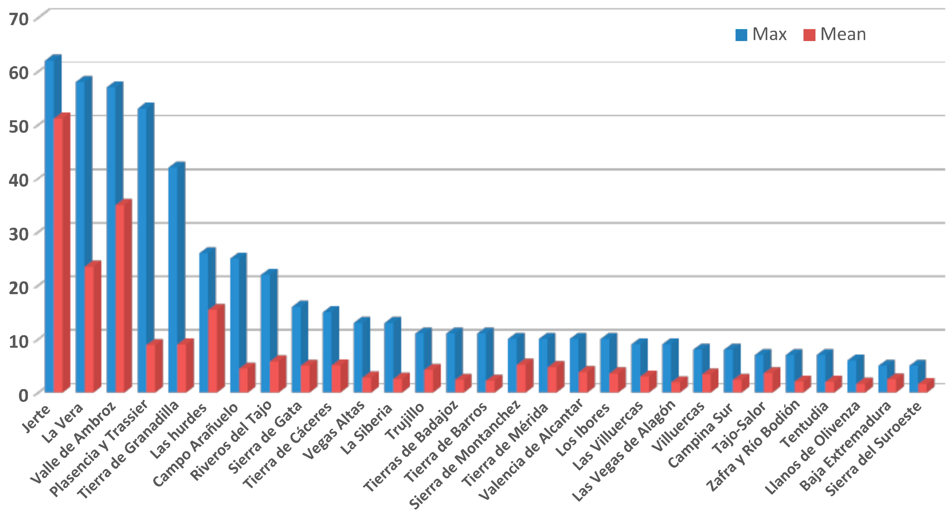
3.2. Analysis of the Potential of Rural Tourism
4. Conclusions
Acknowledgments
Author Contributions
Conflicts of Interest
References
- World Tourism Organization (UNWTO). Tourism, Key to Development, Prosperity and Well-Being; World Tourism Organization (UNWTO): Madrid, Spain, 2016. [Google Scholar]
- Gutiérrez-Domènech, M. Impacto Económico del Sector Turístico en España. Available online: http://www.caixabankresearch.com/1405im-d4-es (accessed on 4 November 2016). (In Spanish)
- Albaladejo, I.P.; González-Martínez, M.I.; Martínez-García, M.P. Quality and endogenous tourism: An empirical approach. Tour. Manag. 2014, 41, 141–147. [Google Scholar] [CrossRef]
- Exceltur Valoración Turística Empresarial de 2015 y Perspectivas Para 2016. Available online: http://www.exceltur.org/perspectivas-turisticas/ (accessed on 4 November 2016). (In Spanish)
- Masot, A.; Gascón, J. The rural model and the impact of the LEADER and PRODER program in Extremadura (Methodological proposed). Scr. Nova-Revista Electron. Geogr. y Ciencias Soc. 2010, 14, 1–25. [Google Scholar]
- Antonio, J.; Jiménez, M.; Vargas, M.V. An Analysis of Cultural Tourism in Castilla-La Mancha (Spain): The impact of the European Rural Tourism Development Programs LEADER and PRODER. Estud. y Perspect. en Tur. 2008, 17, 359–370. [Google Scholar]
- Ciolac, R.; Csosz, I.; Petroman, C.; Petroman, I.; Marin, D.; Dincu, A.; Rujescu, C.; Stanciu, S. Public-private Partnerships on Rural Tourism Field in Europe an Innovation for Rural Development—Achievements and Proposals. Anim. Sci. Biotechnol. 2013, 46, 387–392. [Google Scholar]
- García Henche, B. Características diferenciales del producto turismo rural. Cuad. Tur. 2005, 15, 113–133. (In Spanish) [Google Scholar]
- Pascariu, G.C.; Tiganasu, R. Tourism and sustainable regional development in Romania and France: An approach from the perspective of new economic geography. Amfiteatru Econ. 2014, XVI, 1089–1110. [Google Scholar]
- Dwyer, L.; Kim, C. Destination Competitiveness: Determinants and Indicators. Curr. Issues Tour. 2003, 6, 369–414. [Google Scholar] [CrossRef]
- Gomezelj, D.O.; Mihalič, T. Destination competitiveness—Applying different models, the case of Slovenia. Tour. Manag. 2008, 29, 294–307. [Google Scholar] [CrossRef]
- Maleki, M.R.; Moradi, E.; Parsa, S. Rural tourism as a way to rural development. Int. J. Acad. Res. 2014, 6, 79–84. [Google Scholar]
- Komppula, R. Developing rural tourism in Finland through entrepreneurship. In Tourism in the New Europe: Perspectives on SME Policies and Practices; Thomas, R., Marcjanna, A., Eds.; Elsevier: Oxford, UK, 2007; pp. 123–133. [Google Scholar]
- Komppula, R. The role of individual entrepreneurs in the development of competitiveness for a rural tourism destination—A case study. Tour. Manag. 2014, 40, 361–371. [Google Scholar] [CrossRef]
- McDonald, G.T.; Brown, A.L. The land suitability approach to strategic land-use planning in urban fringe areas. Landsc. Plan. 1984, 11, 125–150. [Google Scholar] [CrossRef]
- Malczewski, J. GIS-based multicriteria decision analysis: A survey of the literature. Int. J. Geogr. Inf. Sci. 2006, 20, 703–726. [Google Scholar] [CrossRef]
- Hjalager, A.-M. Agricultural diversification into tourism: Evidence of a European Community development programme. Tour. Manag. 1996, 17, 103–111. [Google Scholar] [CrossRef]
- Sidali, K.L.; Kastenholz, E.; Bianchi, R. Food tourism, niche markets and products in rural tourism: Combining the intimacy model and the experience economy as a rural development strategy. J. Sustain. Tour. 2013, 9582, 1–19. [Google Scholar] [CrossRef]
- Rivero, M.S.; Martín, J.M.S.; Gallego, J.I.R. Methodological approach for assessing the potential of a rural tourism destination: An application in the province of Cáceres (Spain). Curr. Issues Tour. 2016, 19, 1084–1109. [Google Scholar] [CrossRef]
- Lee, S.-H.; Choi, J.-Y.; Yoo, S.-H.; Oh, Y.-G. Evaluating spatial centrality for integrated tourism management in rural areas using GIS and network analysis. Tour. Manag. 2013, 34, 14–24. [Google Scholar] [CrossRef]
- Aklıbaşında, M.; Bulut, Y. Analysis of terrains suitable for tourism and recreation by using geographic information system (GIS). Environ. Monit. Assess. 2014, 186, 5711–5719. [Google Scholar] [CrossRef]
- Stojanov, S.; Besermenji, S. Measuring Tourism Potential of Places of Interest and Memorial Objects Using Analytical Hierarchy Process (AHP)—Case Study City of Nis, Serbia. Eur. Res. 2013, 59, 2306–2316. [Google Scholar]
- Valle Junior, R.F.; Varandas, S.G.P.; Sanches Fernandes, L.F.; Pacheco, F.A.L. Environmental land use conflicts: A threat to soil conservation. Land Use Policy 2014, 41, 172–185. [Google Scholar] [CrossRef]
- Xu, Y.; Sun, J.; Zhang, J.; Xu, Y.; Zhang, M.; Liao, X. Combining AHP with GIS in synthetic evaluation of environmental suitability for living in China’s 35 major cities. Int. J. Geogr. Inf. Sci. 2012, 26, 1603–1623. [Google Scholar] [CrossRef]
- Kumar, T.; Gautam, A.K.; Kumar, T. Appraising the accuracy of GIS-based Multi-criteria decision making technique for delineation of Groundwater potential zones. Water Resour. Manag. 2014, 28, 4449–4466. [Google Scholar] [CrossRef]
- Varju, V.; Suvak, A.; Dombi, P. Geographic Information Systems in the Service of Alternative Tourism—Methods with Landscape Evaluation and Target Group Preference Weighting. Int. J. Tour. Res. 2014, 16, 496–512. [Google Scholar] [CrossRef] [Green Version]
- Ardeshir, A.; Mohseni, N. Selection of a Bridge Construction Site Using Fuzzy Analytical Hierarchy Process in Geographic Information System. Arab. J. Sci. Eng. 2014, 39, 4405–4420. [Google Scholar] [CrossRef]
- Xiaorui, Z.; Chuanglin, F.; Zhenbo, W.; Haitao, M. Urban Construction Land Suitability Evaluation Based on Improved Multi-criteria Evaluation Based on GIS (MCE-GIS): Case of New Hefei City, China. Chin. Geogr. Sci. 2013, 23, 740–753. [Google Scholar]
- Javadian, M.; Shamskooshki, H.; Momeni, M. Application of Sustainable Urban Development in Environmental Suitability Analysis of Educational Land Use by Using Ahp and Gis in Tehran. Procedia Eng. 2011, 21, 72–80. [Google Scholar] [CrossRef]
- Jeong, J.S.; García-Moruno, L.; Hernández-Blanco, J. A site planning approach for rural buildings into a landscape using a spatial multi-criteria decision analysis methodology. Land Use Policy 2013, 32, 108–118. [Google Scholar] [CrossRef]
- Jeong, J.S.; García-Moruno, L.; Hernández-Blanco, J.; Jaraíz-Cabanillas, F.J. An operational method to supporting siting decisions for sustainable rural second home planning in ecotourism sites. Land Use Policy 2014, 41, 550–560. [Google Scholar] [CrossRef]
- Pourebrahim, S.; Hadipour, M.; Mokhtar, M.B. Integration of spatial suitability analysis for land use planning in coastal areas; case of Kuala Langat District, Selangor, Malaysia. Landsc. Urban Plan. 2011, 101, 84–97. [Google Scholar] [CrossRef]
- Vaz, E.D.N.; Nijkamp, P.; Painho, M.; Caetano, M. A multi-scenario forecast of urban change: A study on urban growth in the Algarve. Landsc. Urban Plan. 2012, 104, 201–211. [Google Scholar] [CrossRef]
- Jaraíz Cabanillas, F.J.; Mora Aliseda, J.; Gutiérrez Gallego, J.A.; Jeong, J.S. Comparison of regional planning strategies: Countywide general plans in USA and territorial plans in Spain. Land Use Policy 2013, 30, 758–773. [Google Scholar] [CrossRef]
- Gannona, A. Rural tourism as a factor in rural community economic development for economies in transition. J. Sustain. Tour. 1994, 2, 51–60. [Google Scholar] [CrossRef]
- Cànoves, G.; Villarino, M.; Herrera, L. Public policies, rural tourism and sustainability: A difficult balance. Boletín la Asoc. Geógrafos Españoles 2006, 41, 199–217. [Google Scholar]
- Saaty, T.L. The Analytic Hierarchy Process; McGraw Hill: New York, NY, USA, 1980. [Google Scholar]
- Saaty, T.L. How to make a decision: The analytic hierarchy process. Eur. J. Oper. Res. 1990, 48, 9–26. [Google Scholar] [CrossRef]
- Aznar Bellver, J.; Guijarro Martínez, F. Nuevos Métodos de Valoración. Modelos Multicrieterio; Editorial Universitat Politècnica de València: Valencia, Spain, 2012. (In Spanish) [Google Scholar]
- Lozano-Oyola, M.; Blancas, F.J.; González, M.; Caballero, R. Sustainable tourism indicators as planning tools in cultural destinations. Ecol. Indic. 2012, 18, 659–675. [Google Scholar] [CrossRef]
- Malczewski, J. Ordered weighted averaging with fuzzy quantifiers: GIS-based multicriteria evaluation for land-use suitability analysis. Int. J. Appl. Earth Obs. Geoinf. 2006, 8, 270–277. [Google Scholar] [CrossRef]
- Pacheco, J.F.; Contreras, E. Manual Metodológico de Evaluación Multicriterio Para Programas y Proyectos; Comisión Económica para América Latina y el Caribe (CEPAL): Santiago, Chile, 2008. (In Spanish) [Google Scholar]
- Ciepłuch, B.; Mooney, P.; Jacob, R.; Winstanely, A.C. Comparison of the accuracy of OpenStreetMap for Ireland with Google Maps and Bing Maps. In Proceedings of the 9th International Symposium on Spatial Accuracy Assessment in Natural Resuorces and Enviromental Sciences, Leicester, UK, 20–23 July 2010; p. 337.
- Ciepłuch, B.; Mooney, P.; Jacob, R.; Zheng, J.; Winstanely, A.C. Location-based services research and applications. Arch. Photogramm. Cartogr. Remote Sens. 2011, 22, 105–116. [Google Scholar]
- Zielstra, D.; Hochmair, H.H. Positional accuracy analysis of Flickr and Panoramio images for selected world regions. J. Spat. Sci. 2013, 58, 251–273. [Google Scholar] [CrossRef]
- Blancas Peral, F.J.; Guerrero Casas, F.M.; Lozano Oyola, M. The spatial location in the planning of the rural tourism in Andalusia: An approach multicrite rion. Rev. Estudios Reg. 2009, 7585, 83–113. [Google Scholar]
- Liu, Y.; Lv, X.; Qin, X.; Guo, H.; Yu, Y.; Wang, J.; Mao, G. An integrated GIS-based analysis system for land-use management of lake areas in urban fringe. Landsc. Urban Plan. 2007, 82, 233–246. [Google Scholar] [CrossRef]
- Yu, H.; Liu, P.; Chen, J.; Wang, H. Comparative analysis of the spatial analysis methods for hotspot identification. Accid. Anal. Prev. 2014, 66, 80–88. [Google Scholar] [CrossRef]
- Epanechnikov, V.A. Non-Parametric Estimation of a Multivariate Probability Density. Theory Probab. Appl. 1967, 14, 153–158. [Google Scholar] [CrossRef]
- De Smith, M.; Goodchild, M.; Longley, P. Geospatial Analysis: A Comprehensive Guide to Principles, Techniques and Software Tools; Troubador Publishing Ltd.: Leicester, UK, 2007. [Google Scholar]
- Brunsdon, C. Estimating probability surfaces for geographical point data: An adaptive kernel algorithm. Comput. Geosci. 1995, 21, 877–894. [Google Scholar] [CrossRef]
- Jiménez, A.M. Modelización cartográfica de densidades mediante estimadores Kernel. Treballs Soc. Catalana Geogr. 2005, 155, 445–460. (In Spanish) [Google Scholar]
- Dhami, I.; Deng, J.; Burns, R.C.; Pierskalla, C. Identifying and mapping forest-based ecotourism areas in West Virginia—Incorporating visitors’ preferences. Tour. Manag. 2014, 42, 165–176. [Google Scholar] [CrossRef]
- Leco, F.; Hernández, J.; Campón, A. Rural Tourists and Their Attitudes and Motivations towards the Practice of Environmental Activities such as Agrotourism. Int. J. Environ. Res. 2012, 7, 255–264. [Google Scholar]
- Gao, J.; Barbieri, C.; Valdivia, C. Agricultural Landscape Preferences: Implications for Agritourism Development. J. Travel Res. 2013, 53, 366–379. [Google Scholar] [CrossRef]
- Blue-Flag. Beaches and Marinas with Blue Flag. Available online: http://www.blueflag.org/ (accessed on 4 November 2016).
- Sánchez Ríos, A. Criterios de Actuación Para el Aprovechamiento Paisajístico de las Masas de Agua en el Suelo Rural: Caso Particular de Extremadura. Ph.D. Thesis, Universidad de Extremadura, Extremadura, España, 2008. [Google Scholar]


| Factor Level | W. | Criteria Level | W. | Sub-Criteria Level | W. | G. | Bi. |
|---|---|---|---|---|---|---|---|
| Tourism accommodation offer | 0.3743 | Camping | 0.0288 | Pt | B1 | ||
| Rural hotel | 0.0630 | Pt | B2 | ||||
| Rural house | 0.1934 | Pt | B3 | ||||
| Rural apartment | 0.0892 | Pt | B4 | ||||
| Activities in natural areas | 0.2597 | Visits to touristic places | 0.0781 | National park | 0.0255 | Pol | B5 |
| Natural park | 0.0159 | Pol | B6 | ||||
| Natural reservoir | 0.0159 | Pol | B7 | ||||
| Zone of special conservation (ZSC) | 0.0034 | Pol | B8 | ||||
| Zone of special protection for birds (ZSPB) | 0.0074 | Pol | B9 | ||||
| Natural monuments | 0.0061 | Attr | B10 | ||||
| Suburban parks of conservation | 0.0021 | Pol | B11 | ||||
| Unique trees | 0.0018 | Attr | B12 | ||||
| Hiking trails | 0.0513 | Attr | B13 | ||||
| Hunting | 0.0065 | Pol | B14 | ||||
| Nature photography | 0.0268 | Pt | B15 | ||||
| Bird watching | 0.0375 | Pol | B16 | ||||
| Festivals of regional touristic interest | 0.0360 | Attr | B17 | ||||
| Cycling | 0.0144 | Attr | B18 | ||||
| Fishing | 0.0091 | Pol | B19 | ||||
| Gastronomic offer | 0.1849 | Gastronomic routes | 0.1233 | Attr | B20 | ||
| Restaurants guide “Pata Negra” | 0.0616 | Pt | B21 | ||||
| Cultural activities in natural environments | 0.0864 | Itineraries by historical monuments | 0.0240 | Attr | B22 | ||
| Workshops of agricultural labors | 0.0341 | Attr | B23 | ||||
| Visits to ethnographic museums/interpretation centers | 0.0141 | Attr | B24 | ||||
| Activities of environment education | 0.0141 | Attr | B25 | ||||
| Bath offer in natural environments | 0.0621 | Medicinal spa | 0.0101 | Attr | B26 | ||
| Natural swimming pool | 0.0335 | Attr | B27 | ||||
| Bathing zones | 0.0184 | Attr | B28 | ||||
| Activities in active tourism | 0.0325 | Hiking | 0.0172 | Pol | B29 | ||
| Adventure sports | 0.0076 | Attr | B30 | ||||
| 4 × 4 routes/quads | 0.0054 | Attr | B31 | ||||
| Rappelling/climbing | 0.0023 | Attr | B32 |
© 2016 by the authors; licensee MDPI, Basel, Switzerland. This article is an open access article distributed under the terms and conditions of the Creative Commons Attribution (CC-BY) license (http://creativecommons.org/licenses/by/4.0/).
Share and Cite
González-Ramiro, A.; Gonçalves, G.; Sánchez-Ríos, A.; Jeong, J.S. Using a VGI and GIS-Based Multicriteria Approach for Assessing the Potential of Rural Tourism in Extremadura (Spain). Sustainability 2016, 8, 1144. https://doi.org/10.3390/su8111144
González-Ramiro A, Gonçalves G, Sánchez-Ríos A, Jeong JS. Using a VGI and GIS-Based Multicriteria Approach for Assessing the Potential of Rural Tourism in Extremadura (Spain). Sustainability. 2016; 8(11):1144. https://doi.org/10.3390/su8111144
Chicago/Turabian StyleGonzález-Ramiro, Abel, Gil Gonçalves, Alonso Sánchez-Ríos, and Jin Su Jeong. 2016. "Using a VGI and GIS-Based Multicriteria Approach for Assessing the Potential of Rural Tourism in Extremadura (Spain)" Sustainability 8, no. 11: 1144. https://doi.org/10.3390/su8111144