1. Introduction
Land use and land cover change (LUCC) is one of the important focuses in the area of global environmental change research because it is not only the significant component but also the major reason of global changes [
1,
2]. Currently, LUCC is focusing on key areas, which have the important strategic roles in global changes (e.g., tropical rainforest), hot spots, which have active artificial and natural driving force (e.g., Beijing City), and vulnerable regions that have the fragile ecological environment features (e.g., ecotone between agriculture and animal husbandry) [
3]. Along with the openness of neighboring countries and the enhancement of economic trade, border regions with geopolitical and geo-economic advantages with a special role in the international political and economic environment undergo dramatic LUCC, which significantly influences border security and ecological security. Therefore, border regions have undoubtedly become the hot and critical areas for LUCC research. It is of great academic and practical significance for studying LUCC in the frontier regions [
4,
5].
LUCC is a complex process subjected to the interactions between natural and social systems at different spatial and temporal scales. Border regions usually with homogenous natural landscape but different socio-economic systems have gained much attention in the field of LUCC studies, such as land cover and landscape pattern change in the trans-boundary areas of Eastern Europe [
6], quantitative estimates of land cover in Israel-Egypt border arid regions [
7], LUCC and ecological security in the trans-boundary China-North Korea [
8], and LUCC and its environmental effects in the border region of China, Laos, Myanmar [
4,
9,
10,
11]. With the opening up of the border in northern Laos, multiple geo-economic cooperation mechanisms were launched, including the “Golden Economic Quadrangle Region” in the borders of China, Laos, Myanmar and Thailand in 1993, and the China-ASEAN (Association of Southeast Asian Nations) Free Trade Area in 2010, etc. Therefore, LUCC in northern Laos becomes increasingly extensive and dramatic [
12]. Regional major economies influence the mode of trade, the movement of people, as well as local farming systems and livelihoods in northern Laos [
13]. Specifically, land use in northern Laos is likely to be affected by the improvement of Road Number 3 (R3), or the international economic corridor called as the Kunming-Bangkok Highway [
5,
12]. The rate and intensity of land use change are accelerated and enhanced gradually after that highway construction [
12,
14]. Roads and paved highways provide an economic impetus for industrial logging, agribusiness, mining, and tourism, which are the main driving forces of LUCC in tropical rainforests [
15].
LUCC is driven by synergetic factor combinations of resource scarcity, changing opportunities created by markets, external policy intervention, loss of adaptive capacity, and changes in social organization and attitudes [
16]. Alternatively, large-scale plantation and intensive agricultural projects increase migrant involvement with commercial cultivation, often at the expense of indigenous people near the forest frontier, where land conflicts follow exist [
17,
18]. For centuries, swidden cultivation (also referred as shifting or slash-and-burn cultivation), being a rational economic and environmental choice for farmers, has been one of the most important land use systems in the humid tropical uplands [
19,
20]. Northern Laos severely restricted geographically and socioeconomically was the main distribution area of that farming method [
21,
22]. Since the implementation of REDD (Reducing Emissions from Deforestation in Developing countries) by the United Nations, an increasing attention has been given to swidden agriculture in the humid tropics nationally and internationally. The dominant land categories are forest land and grassland in northern Laos [
23], and rainfed paddy predominates in agricultural land. However upland rice cultivation through swiddening accounts for 48.9% of rice fields [
24]. Tropical deforestation is largely driven by changing economic factors, which are linked to social, political, and infrastructural changes [
25,
26,
27]. Furthermore, it is negatively correlated with population growth, poverty, and swidden cultivation [
28,
29]. The area of traditional upland agriculture and swidden farming has decreased, while permanent intensive agriculture has increased, and commercial agricultural production of cash crops rose at the expense of subsistence agricultural production [
30]. The most extensive and rapid change in the uplands of northern Laos is the expansion of smallholder rubber plantation, encouraged by governmental land use policy, which is a result of increasing integration with the regional economies of Southeast Asia, particularly southern China [
31]. Much of the upland areas that have been converted to rubber plantation in the region are historically associated with swidden cultivation [
25,
32,
33]. Rubber plantation was established in 1994 in Luang Namtha Province, and displayed a rapid pace since 2003 in responding to high rubber prices due to the growth in demand from China [
34]. The area of forest land decreased greatly, and followed by bamboo and grassland. However, the area of unstocked forest, slash and burn and rice paddy land increased in the trans-boundary Laos-China Biodiversity Conservation Area that is called the Namha National Biodiversity Conservation Areas [
11].
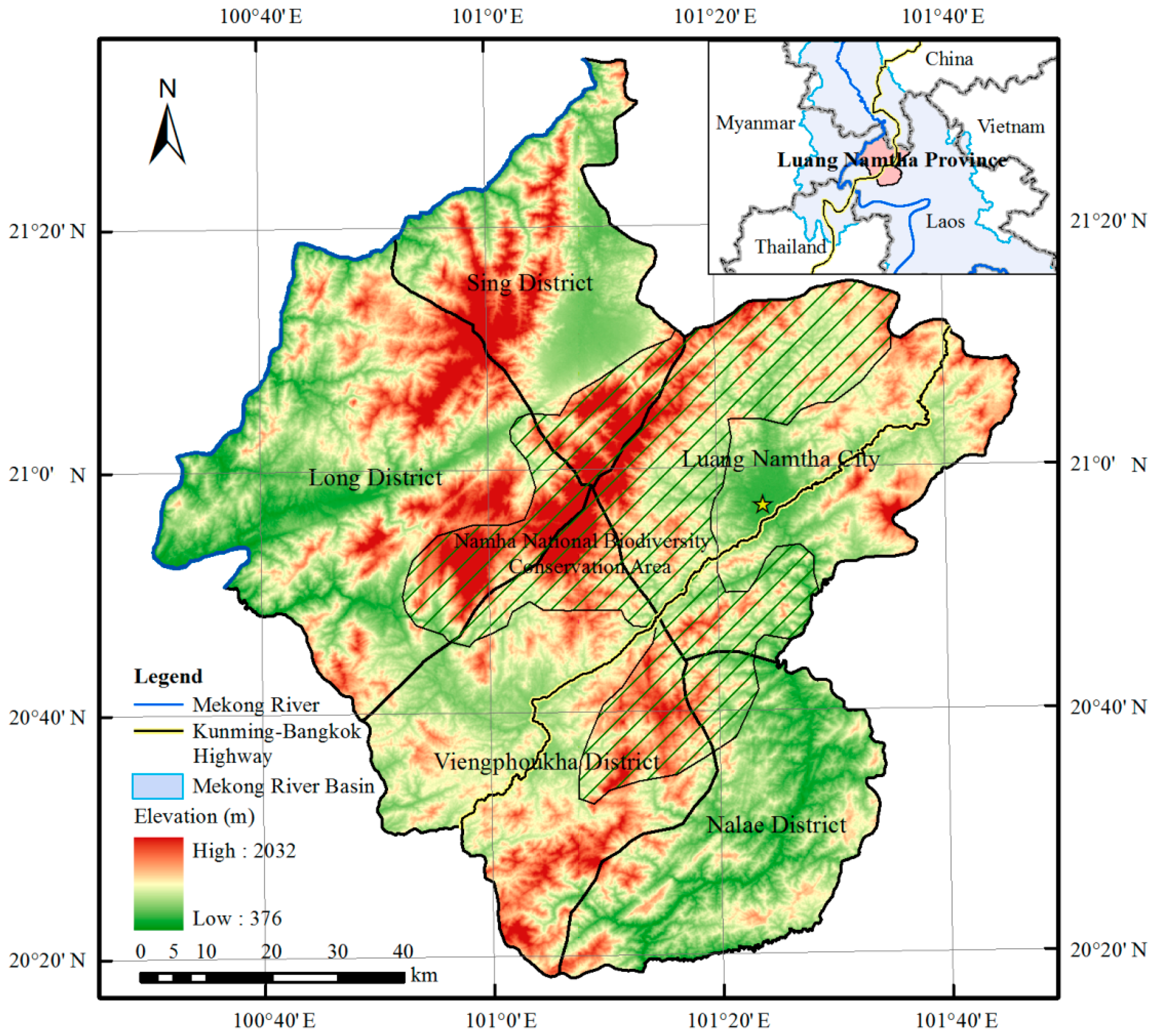
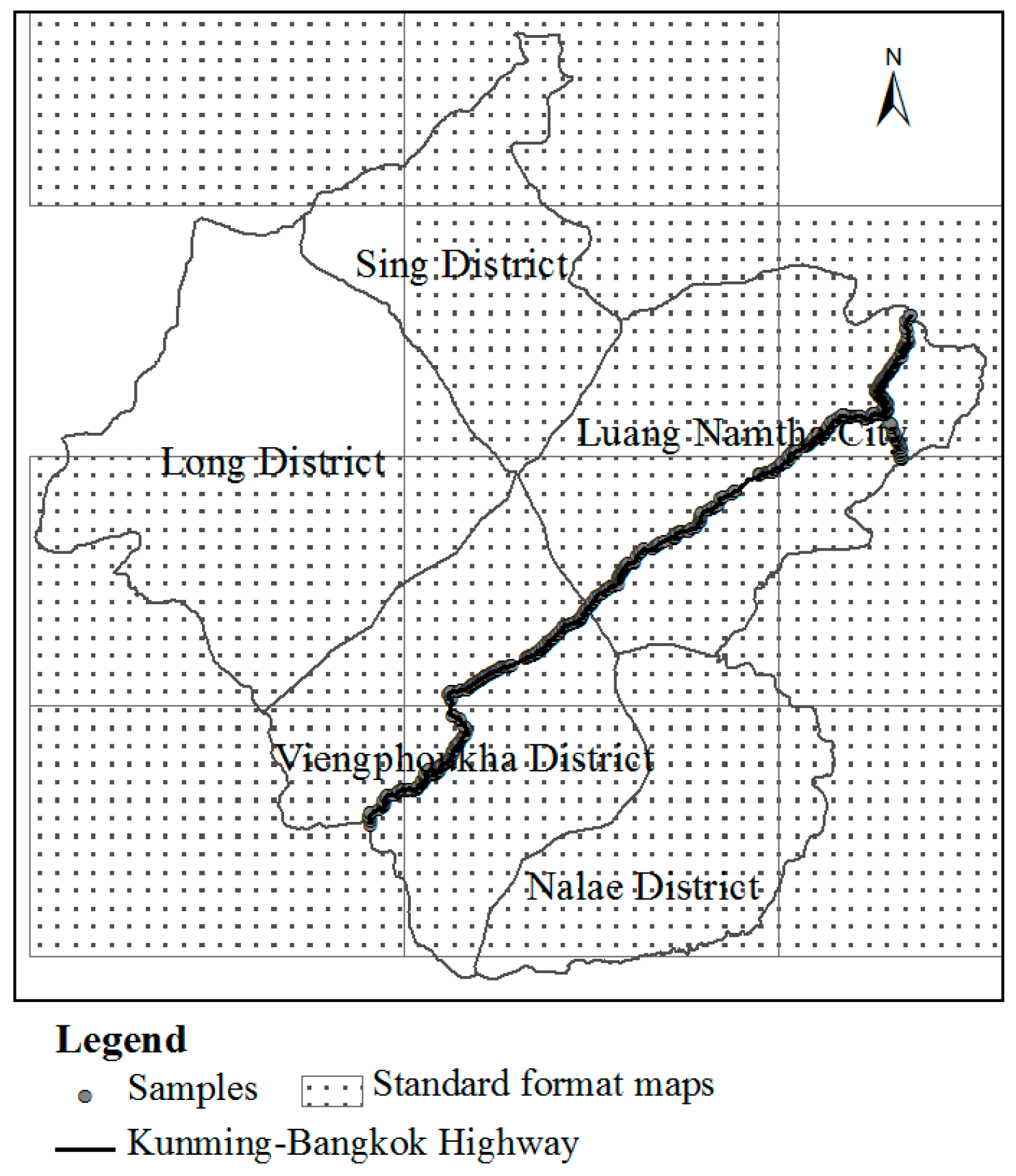
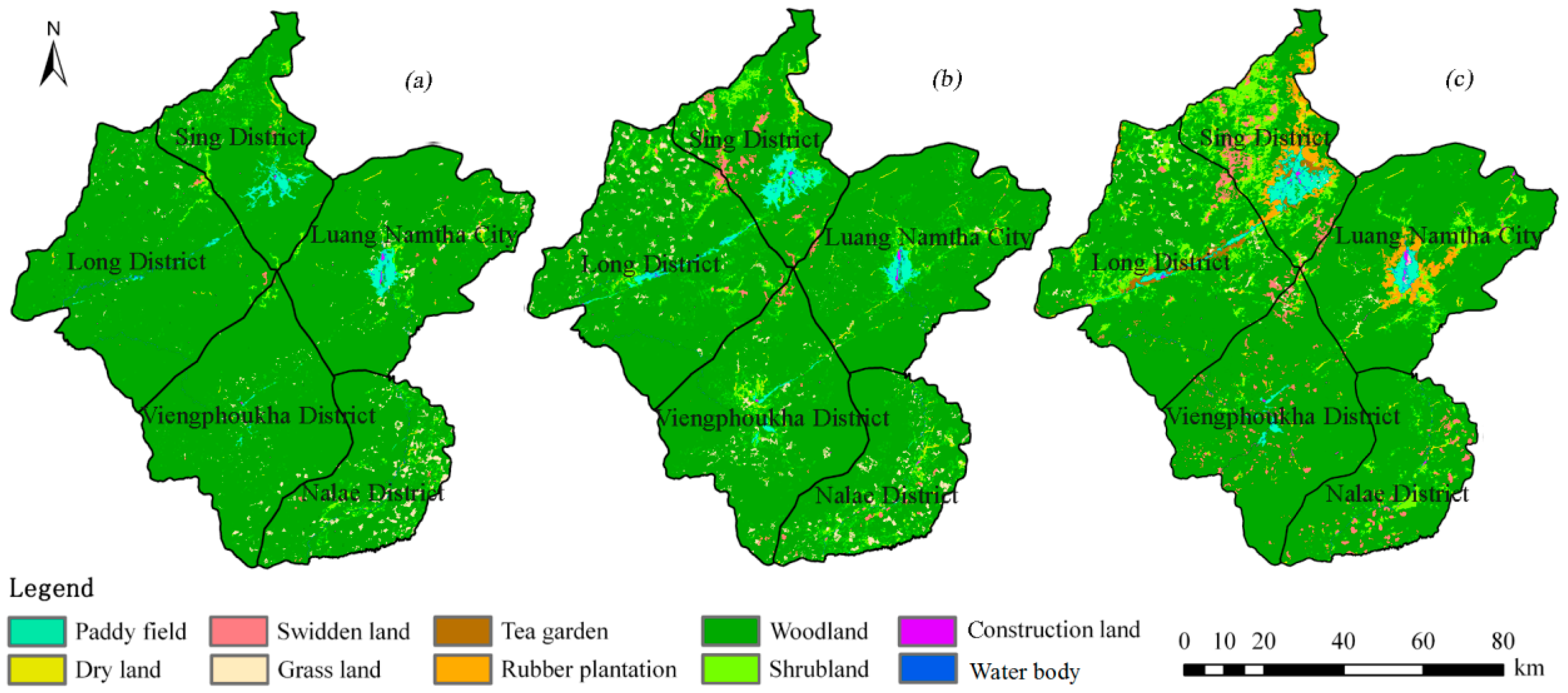
Understanding LUCC in the border region has tremendous implication for land management and planning and border security. It is significant for sustainable development of international trade and commerce. Luang Namtha Province has been constantly experiencing LUCC since the opening of the Boten border in 1994. Land use and land cover classification maps were extracted by interpreting Landsat TM/ETM+ images in 1990, 2000 and 2010 using decision tree classification method. LUCC was analyzed from the perspectives of structure, type conversion, and spatial pattern. The objective of this study was to find out the main changing characteristics of swidden land and rubber plantation systematically for decision support and scientific basis of sustainable land use management and ecological environment protection in Luang Namtha Province of northern Laos.
4. Conclusions and Discussion
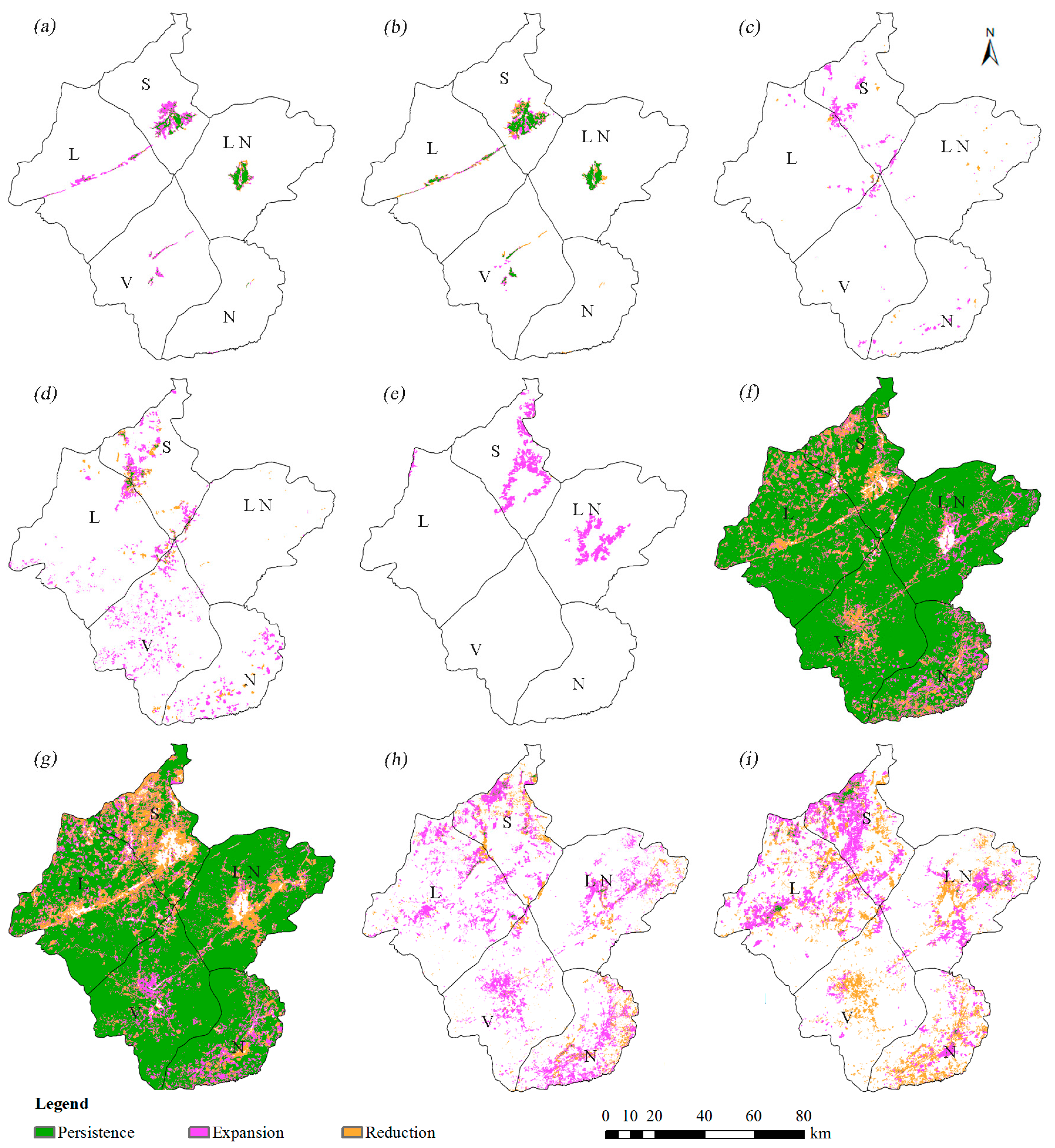
Spatial-temporal changes of land use and land cover in Luang Namtha Province were investigated since the opening of the Boten border adjacent to China from 1990 to 2010. Structure change, type change and distribution change were analyzed, respectively. This research aimed to understand the use of natural resources using LUCC analyses, and provide the basic support for land resource development and ecological environmental protection.
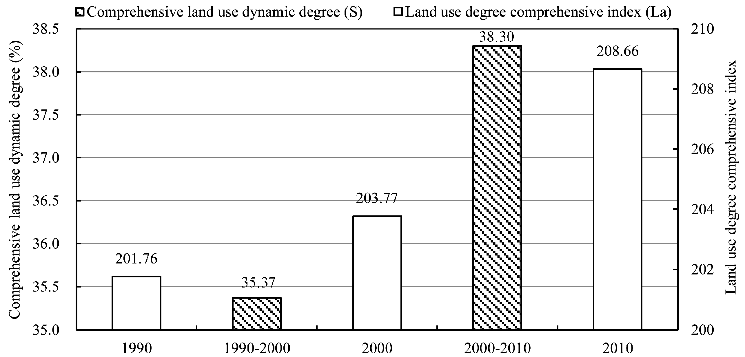
Land use intensity was enhanced obviously because of the disturbance of human activities on LUCC [
30], especially in the recent decade. The land use degree comprehensive index increased from 201.76 to 208.66, and the comprehensive land use dynamic degree increased from 35.37% to 38.30%. Woodland, shrubland, rubber plantation, swidden land and paddy field changed significantly in distribution from 1990 to 2010. As the dominant land use type during 1990–2000, paddy field was replaced by rubber plantation in 2010 with 2.39%. Rubber plantation, shrubland, swidden land, and construction land showed significant expansion, but obvious reduction in woodland in the same period. Woodland was mainly converted into shrubland, rubber plantation and grassland, with a small proportion of natural recovery from grassland. Woodland reduction was so obvious, especially in northern part of three districts (e.g., Sing District, Long District, and Luang Namtha City) and the areas along the Kunming–Bangkok highway [
12]. Population growth and swidden agriculture were the primary causes of deforestation [
17,
29,
32]. Rubber plantation was mainly distributed in the border region of China and Laos with the expansion from the border region into the non-frontier of Laos with Luang Namtha City as the center. This phenomenon was similar to the expansion features in Xishuangbanna, China [
37,
46]. Economic interests and national policies were the primary causes of rubber expansion [
10,
16,
32,
45,
46,
47]. Swidden land was mainly located in northern mountainous areas, where the obvious expansion indicated human activities have frequently impacted slashing and burning cultivation in the recent decade [
33,
48]. As a traditional farming practice in tropical regions, the increment of swidden land was mainly resulted due to poverty [
19,
22,
48].
In this study, we focused on LUCC in Luang Namtha Province, the border region of China and Laos, and obtained the land use and land cover classification maps since the opening of the Boten border crossings with higher spatial resolution (30 m) and longer temporal scale (20 years). Most of the existing studies had lower spatial precision and an older temporal scale [
9,
30,
33,
45]. Research performed mainly focused on changes of the structure and type conversion, while we analyzed LUCC from the perspectives of structure, type conversion and spatial pattern [
23,
33]. We paid more attention to the changes of swidden land and rubber plantation, which were affected significantly by human activities [
24,
31,
32,
47,
48]. In light of the quality of Landsat images and limited field samples, accuracy assessment of land use and land cover classification maps should be improved further, especially for the grassland and tea garden. For the vegetation types with obvious growth cycles, higher spatial resolution remote sensing images and multi-temporal Landsat images can obviously improve the classification accuracy [
46]. References from the Xishuangbanna region that have similar geographical environment and classification data of “The Second National Land Resource Survey”, and more field survey samples obtained in the future will be used to improve the classification accuracy based on our research projects. This study has primarily focused on the spatial-temporal of LUCC and land use intensity, while analyses of the driving forces of natural and human factors (e.g., terrain, policy, soil characteristics) and stakeholders should be carried out in future research. The Kunming-Bangkok highway across the Namha National Biodiversity Conservation Areas becomes the major driving force of land use and land cover change and economic development in the future because of different international cooperation mechanisms. However, the road construction is a great challenge for biodiversity and ecological environment protection. More related dynamic research and measures should be carried out for avoiding negative ecological effects.
Located in the northern part of Laos, Luang Namtha Province is adjoined to Xishuangbanna in southwest China with abundance in land, heat, water, biodiversity, and humanity resources. Meanwhile, as the frontier region adjacent to the border to China in Laos, land use and land cover will greatly be affected by Chinese border agricultural policies, especially rubber plantation expansion [
10,
47]. Investments from China, Vietnam, Thailand, etc. in rubber plantations in Laos have been obviously increasing since 2004 [
32,
49]. Laos is devoted to becoming an important exporter of natural rubber in 2020 [
50]. Furthermore, with the “Opium Poppy Substitution Planting” (OPSP) being an important filing of cooperation in the neighboring countries of the “Golden Triangle,” vital projects supported by national and international organizations and more frequent economic exchanges after the establishment of China-ASEAN Free Trade Area, there is no doubt that land use and land cover will be changed more extensively and dramatically, especially in rubber plantation [
10,
32]. More attention should be paid to growing potential evaluation of rubber plantations in the border region of China, Laos, and Myanmar. Based on scenario analysis, simulations of LUCC should be enhanced in northern Laos to analyse future potential environmental consequences and to help planning for land resource development and ecological environmental protection in the border region of China and Laos. Simultaneously, environmental effects of LUCC should be studied with more detailed data from investigation to experiments, especially in hydrology and ecosystems. As a developing region, along with the international political-economic cooperation, LUCC in northern Laos will undoubtedly affect the geopolitical and economic environment.


