
Utilizing the Analytic Hierarchy Process to Establish Weighted Values for Evaluating the Stability of Slope Revegetation based on Hydroseeding Applications in South Korea


Abstract
:1. Introduction
2. Methods
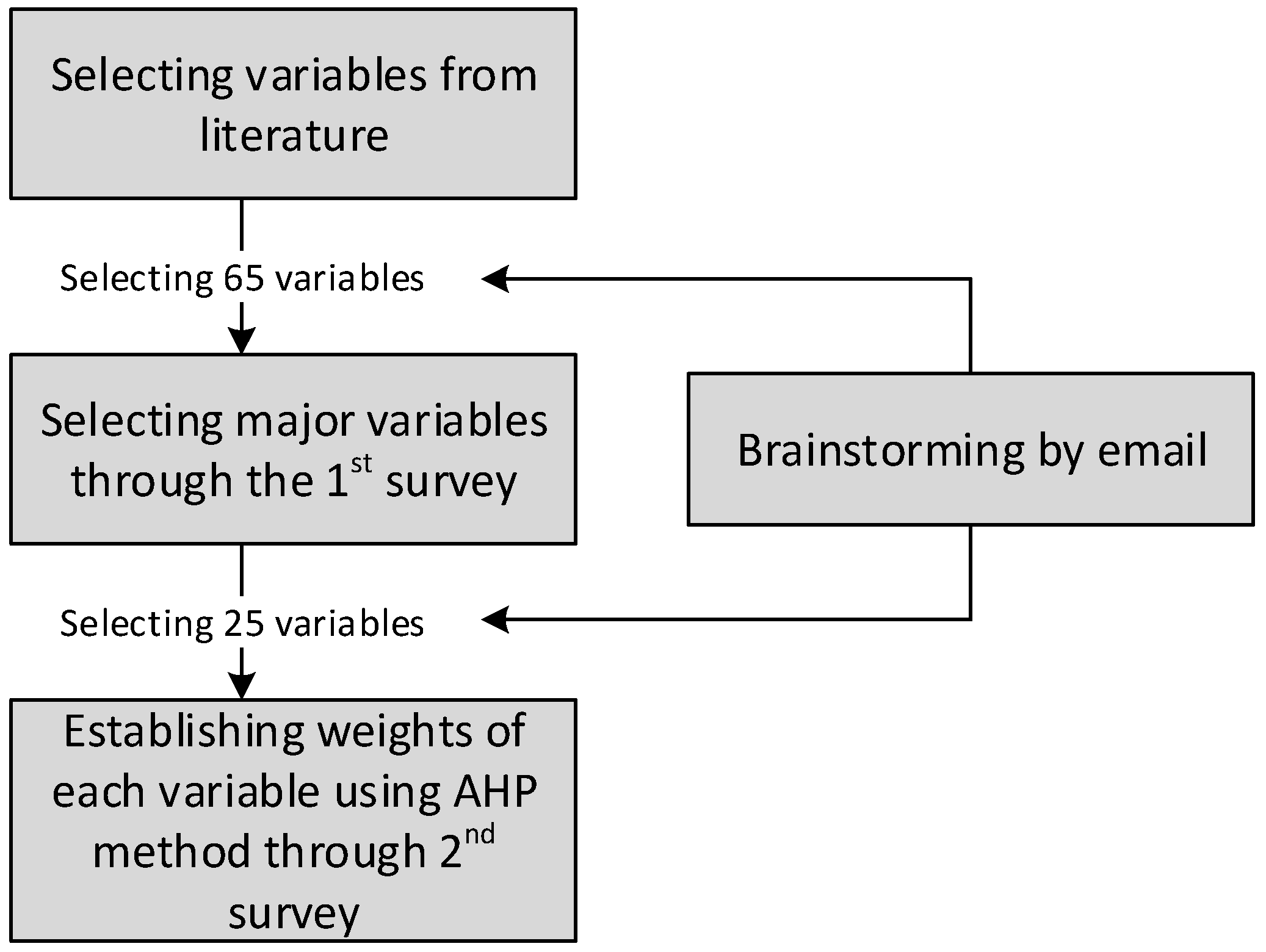
2.1. Variable Selection and Survey Method


| Categories | Major Variables | References |
|---|---|---|
| Topography | Slope angle, Slope height, Slope location, Slope type, Slope length, Altitude, Aspect, Curvature, Catchment basin, Stream power index (SPI), Topographic wet index (TWI) | [39,40,41,42,43,44,45,46,47] |
| Geology | Ground layer, Rock type, Joint condition, Joint orientation, Weathering characteristics, Weathered condition, Tension crack, Seepage water | [39,40,41,42,43,48,49,50] |
| Climate | Rain intensity, Daily rainfall, Accumulated rainfall | [39,40,44,47,51] |
| Soil physics | Porosity, Bulk density, Gravel contents, Grain size, Soil hardness, Water content, Soil texture, Permeability coefficient, Tensile strength, Shear strength, Specific gravity | [22,40,43,46,47,51,52,53,54,55,56,57,58] |
| Soil chemistry | Soil acidity (pH), Cation Exchange Capacity (CEC), Electronic conductivity (EC), Available phosphate, Soil organic matter, C/N, Salt concentration, Total nitrogen (T-N), Exchangeable calcium, Exchangeable magnesium, Exchangeable potassium, Exchangeable sodium | [43,55,59] |
| Vegetation | Forest stand, Tree height, Species diversity, Dominant plant species, Number of trees, Number of herbs, Vegetation coverage, Vegetation density, Germination percentage, Vegetation community, Timber age class, Timber diameter class, Root reinforcement | [40,46,54,55,58,60,61,62] |
| Construction | Soil depth, Land use, Drainage system, Elapsed year, Scale of failure, Collapse history, Reinforced facility for slope protection | [39,45,46,57,62] |
| Categories | Extracted Variables |
|---|---|
| Topography | Slope angle, Aspect, Slope length, Slope height, Slope type |
| Geography | Ground condition, Seepage water |
| Climate | Rain intensity, Accumulated rainfall |
| Soil physics | Porosity, Soil hardness, Water contents, Soil texture, Tensile strength, Hydraulic conductivity |
| Soil chemistry | Soil acidity (pH), Salt concentration, Organic Matter |
| Vegetation | Vegetation community, Vegetation coverage rate, Number of trees, Number of herbs |
| Construction | Elapsed year, Drainage condition, Soil depth |
| Classification | First Survey | Second Survey | |
|---|---|---|---|
| Major | Environment | 28 | 23 |
| Civil engineering | 9 | 15 | |
| Career | Above 10 years | 25 | 27 |
| 6 to 9 years | 10 | 8 | |
| Below 5 years | 2 | 3 | |
| Organization | Educational institution | 10 | 11 |
| Government | 3 | 10 | |
| Private company | 24 | 17 | |
| Total | 37 | 38 | |
2.2. AHP Analysis
| Intensity of importance | Definition | Explanation |
|---|---|---|
| 1 | Equal importance | Two categories or variables contribute equally to the objective |
| 3 | Moderate importance | Experience and judgment slightly favor one category or variable over another |
| 5 | Strong importance | Experience and judgment strongly favor one category or variable over another |
| 7 | Very strong or demonstrated importance | An category or variable is favored very strongly over another; its dominance demonstrated in practice |
| 9 | Extreme importance | The evidence favoring one category or variable over another is of the highest possible order of affirmation |
| Reciprocals of above | If activity i has one of the above nonzero numbers assigned to it when compared with activity j, then j has the reciprocal value when compared with i | A reasonable assumption |
| Rational | Ratios arising from the scale | If consistency were to be forced by obtaining n numerical values to span the matrix |
| n | 1 | 2 | 3 | 4 | 5 | 6 | 7 |
|---|---|---|---|---|---|---|---|
| RI | 0 | 0 | 0.58 | 0.9 | 1.12 | 1.24 | 1.32 |
3. Results
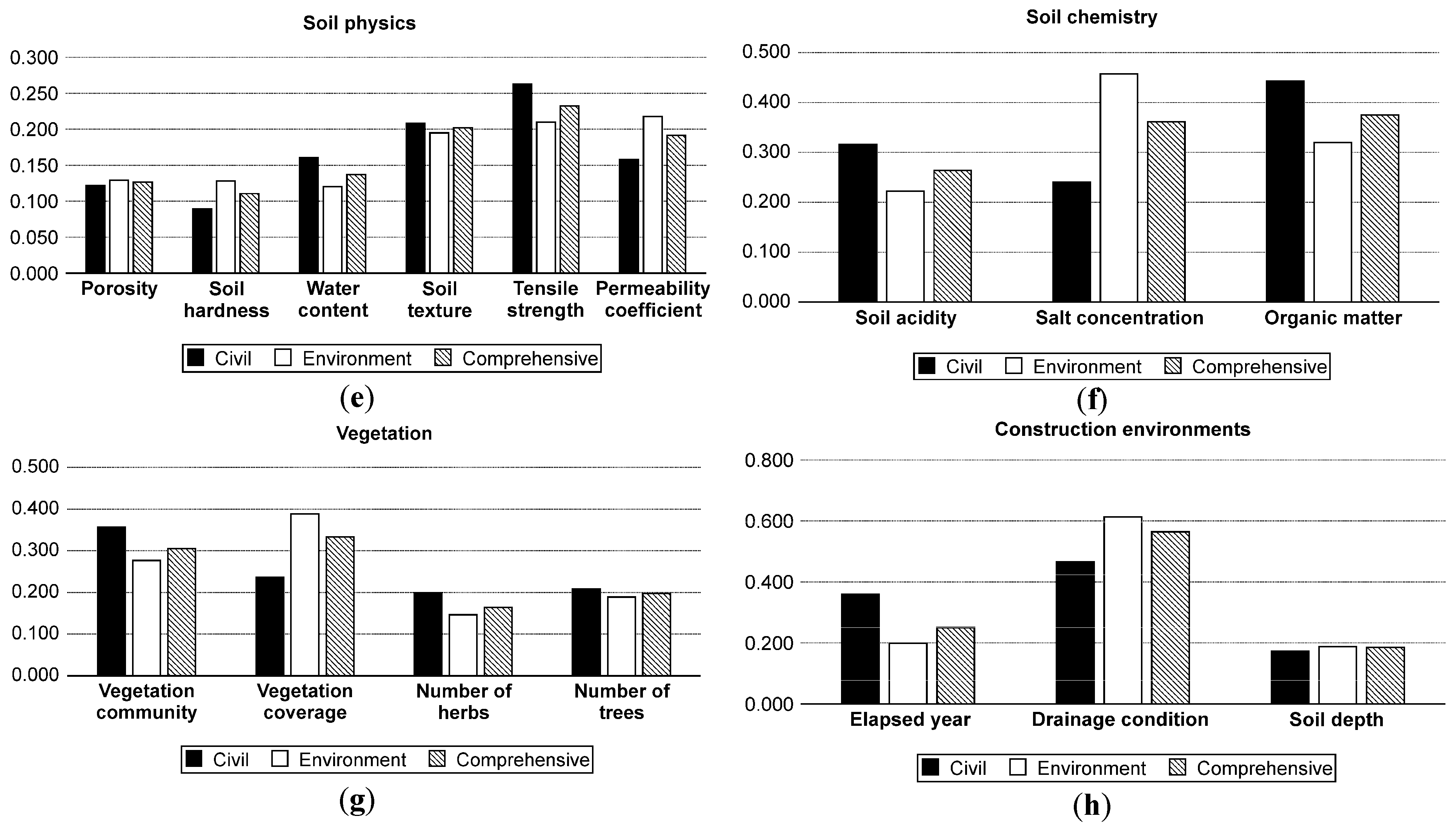
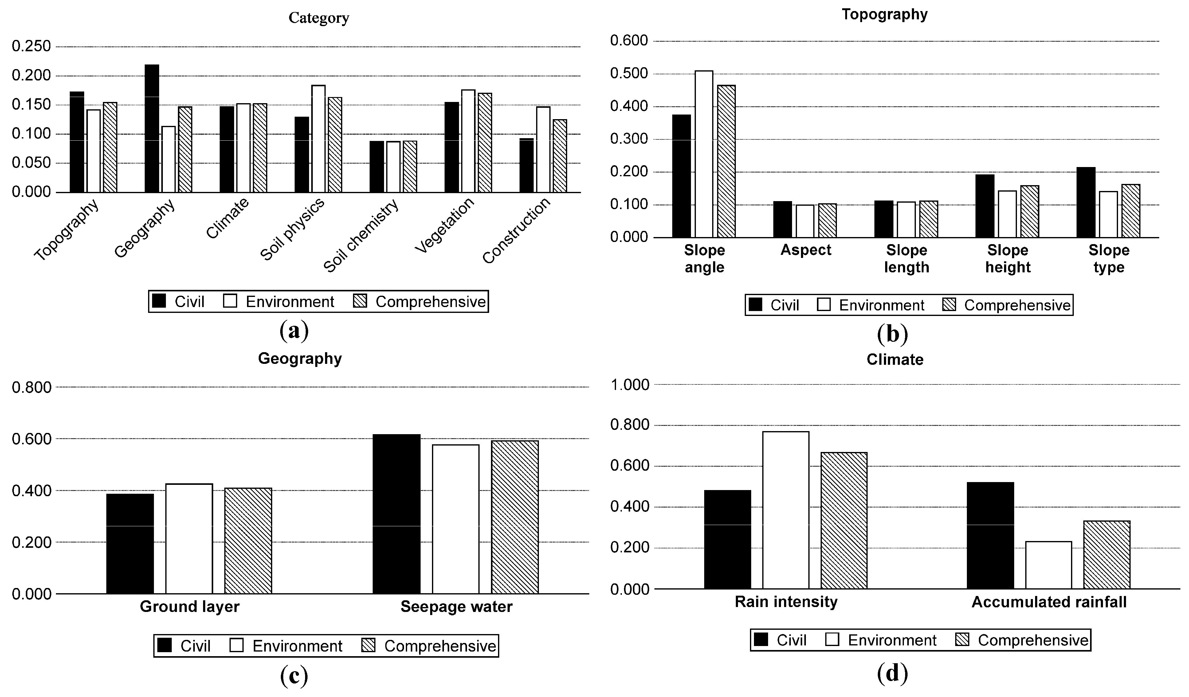
3.1. Tendencies for Weighted Factors
3.1.1. Weighted Values of Environmental Experts
| Categories | Local Weight | Variables | Local Weight | Global Weight | Rank |
|---|---|---|---|---|---|
| Topography | 0.142 | Slope angle | 0.509 | 0.0723 | 3 |
| Aspect | 0.099 | 0.0141 | 25 | ||
| Slope length | 0.109 | 0.0155 | 24 | ||
| Slope height | 0.142 | 0.0202 | 21 | ||
| Slope type | 0.141 | 0.0200 | 22 | ||
| Geography | 0.113 | Ground layer | 0.424 | 0.0479 | 7 |
| Seepage water | 0.576 | 0.0651 | 5 | ||
| Climate | 0.152 | Rain intensity | 0.769 | 0.1169 | 1 |
| Accumulated rainfall | 0.231 | 0.0351 | 12 | ||
| Soil physics | 0.183 | Porosity | 0.129 | 0.0236 | 18 |
| Soil hardness | 0.128 | 0.0234 | 19 | ||
| Water content | 0.121 | 0.0221 | 20 | ||
| Soil texture | 0.195 | 0.0357 | 11 | ||
| Tensile strength | 0.210 | 0.0384 | 10 | ||
| Permeability coefficient | 0.218 | 0.0399 | 8 | ||
| Soil chemistry | 0.087 | Soil acidity | 0.222 | 0.0193 | 23 |
| Salt concentration | 0.458 | 0.0398 | 9 | ||
| Organic matter | 0.320 | 0.0278 | 15 | ||
| Vegetation | 0.176 | Vegetation community | 0.277 | 0.0488 | 6 |
| Vegetation coverage rate | 0.388 | 0.0683 | 4 | ||
| Number of trees | 0.146 | 0.0257 | 17 | ||
| Number of herbs | 0.189 | 0.0333 | 13 | ||
| Construction | 0.147 | Elapsed year | 0.199 | 0.0293 | 14 |
| Drainage condition | 0.613 | 0.0901 | 2 | ||
| Soil depth | 0.188 | 0.0276 | 16 |
3.1.2. Weighted Values of Civil Engineers
| Categories | Local Weight | Variables | Local Weight | Global Weight | Rank |
|---|---|---|---|---|---|
| Topography | 0.172 | Slope angle | 0.374 | 0.0643 | 5 |
| Aspect | 0.110 | 0.0189 | 22 | ||
| Slope length | 0.112 | 0.0193 | 21 | ||
| Slope height | 0.191 | 0.0329 | 13 | ||
| Slope type | 0.213 | 0.0366 | 9 | ||
| Geography | 0.219 | Ground layer | 0.385 | 0.0843 | 2 |
| Seepage water | 0.615 | 0.1347 | 1 | ||
| Climate | 0.147 | Rain intensity | 0.480 | 0.0706 | 4 |
| Accumulated rainfall | 0.520 | 0.0764 | 3 | ||
| Soil physics | 0.129 | Porosity | 0.122 | 0.0157 | 24 |
| Soil hardness | 0.089 | 0.0115 | 25 | ||
| Water content | 0.160 | 0.0206 | 19 | ||
| Soil texture | 0.208 | 0.0268 | 17 | ||
| Tensile strength | 0.262 | 0.0338 | 11 | ||
| Permeability coefficient | 0.158 | 0.0204 | 20 | ||
| Soil chemistry | 0.087 | Soil acidity | 0.316 | 0.0275 | 16 |
| Salt concentration | 0.241 | 0.0210 | 18 | ||
| Organic matter | 0.443 | 0.0385 | 8 | ||
| Vegetation | 0.154 | Vegetation community | 0.356 | 0.0548 | 6 |
| Vegetation coverage rate | 0.237 | 0.0365 | 10 | ||
| Number of trees | 0.199 | 0.0306 | 15 | ||
| Number of herbs | 0.208 | 0.0320 | 14 | ||
| Construction | 0.092 | Elapsed year | 0.360 | 0.0331 | 12 |
| Drainage condition | 0.467 | 0.0430 | 7 | ||
| Soil depth | 0.173 | 0.0159 | 23 |
3.2. Weighted Values of Comprehensive Experts.
| Categories | Local Weight | Variables | Local Weight | Global Weight | Rank |
|---|---|---|---|---|---|
| Topography | 0.154 | Slope angle | 0.465 | 0.0716 | 3 |
| Aspect | 0.104 | 0.0160 | 25 | ||
| Slope length | 0.111 | 0.0171 | 24 | ||
| Slope height | 0.158 | 0.0243 | 18 | ||
| Slope type | 0.162 | 0.0249 | 17 | ||
| Geography | 0.147 | Ground layer | 0.409 | 0.0601 | 5 |
| Seepage water | 0.591 | 0.0869 | 2 | ||
| Climate | 0.152 | Rain intensity | 0.668 | 0.1015 | 1 |
| Accumulated rainfall | 0.332 | 0.0505 | 8 | ||
| Soil physics | 0.163 | Porosity | 0.127 | 0.0207 | 22 |
| Soil hardness | 0.111 | 0.0181 | 23 | ||
| Water content | 0.137 | 0.0223 | 21 | ||
| Soil texture | 0.202 | 0.0329 | 12 | ||
| Tensile strength | 0.232 | 0.0378 | 9 | ||
| Permeability coefficient | 0.191 | 0.0311 | 14 | ||
| Soil chemistry | 0.088 | Soil acidity | 0.264 | 0.0232 | 19 |
| Salt concentration | 0.361 | 0.0318 | 13 | ||
| Organic matter | 0.375 | 0.0330 | 11 | ||
| Vegetation | 0.170 | Vegetation community | 0.305 | 0.0519 | 7 |
| Vegetation coverage rate | 0.333 | 0.0566 | 6 | ||
| Number of trees | 0.164 | 0.0279 | 16 | ||
| Number of herbs | 0.198 | 0.0337 | 10 | ||
| Construction | 0.125 | Elapsed year | 0.250 | 0.0313 | 15 |
| Drainage condition | 0.564 | 0.0705 | 4 | ||
| Soil depth | 0.185 | 0.0231 | 20 |
4. Discussion
4.1. Variable Extraction
4.2. Comparison of Weighted Values between Environmental Experts and Civil Engineers

5. Conclusions
Acknowledgments
Author Contributions
Conflicts of Interest
Appendix
| Topography | Unit | Explanation |
|---|---|---|
| Slope angle | ° | Angle of inclination |
| Slope height | m | Straight-line distance from the center of the bottom of a slope to the top of adjacent forests |
| Slope location | - | Location of a revegetated slope |
| Slope type | - | Various types of curved or straightened slope after constructing (Straight (口), Concave (凹), Convex (凸), Compound (凹凸)) |
| Slope width | m | Straight-line distance of lower section in a slope |
| Altitude | m | Altitude above sea level |
| Aspect | ° | Compass direction facing of a slope |
| Curvature | Torsion degree of a curved-slope | |
| Catchment basin | m2 | An area of land having capacity of water resources |
| Stream power index (SPI) | m | Measurement of erosive power connected to flowing water in a certain catchment area |
| Topographic wet index (TWI) | m | Upslope contributing area per width orthogonal to local topographic gradient as a steady state wetness index (frequently used to analyze soil moisture conditions in a certain catchment area) |
| Geology | Unit | Explanation |
| Ground layer | - | Various types of underlying rock or soil after constructing such assoil, weathered rock and blasted rock |
| Rock type | - | Various types of rock such as granite, gneiss and sandstone |
| Joint condition | - | Condition of discontinuities measured from roughness, separation and weathering of joint wall |
| Joint orientation | ° | Dip direction measured with geological compass |
| Weathering characteristics | - | Weathering peculiarity on the bedrock |
| Weathered condition | - | Weathering degree on the bedrock |
| Tension crack | - | A discrete rock fracture forming perpendicularly to the direction of maximum extension |
| Seepage water | - | Sporadic seepage flow when the pores between soils or the hole of a crack in a bedrock become saturated with water and intersect a restrictive layer |
| Climate | Unit | Explanation |
| Rain intensity | mm h−1 | Hourly rainfall |
| Daily rainfall | mm day−1 | Rainfall in a day |
| Accumulated rainfall | mm | Cumulative rainfall in a couple of days |
| Soil physics | Unit | Explanation |
| Porosity | % | Capacity of air-filled voids in dry soil |
| Bulk density | g cm−3 | Measurement as the dry weight of soil divided by its volume |
| Gravel contents | % | Mineral particles larger than 2 mm in diameter |
| Grain size | mm | Particle size referring to the diameter of individual soil |
| Soil hardness | mm | Physical treatment of soil as a result of trampling or by mechanical equipment. (soil compaction) |
| Water content | % | Water quantity contained in a soil |
| Soil texture | - | Systematic arrangement of soils classified into relative ratios of sand, silt, and clay (soil classification) |
| Permeability coefficient | m s−1 | Permeability about how much water in a soil can move though pore fractures (Darcy’s law (Calculation by constant head method using the flux per hour, length of soil column, and hydraulic head)) |
| Tensile strength | kg m−2 | Maximum stress that a soil can withstand while it is stretched before it breaks |
| Shear strength | kg m−2 | Maximum resistance of a structural member or material to shearing stress |
| Specific gravity | % | Ratio of the density of a soil |
| Soil chemistry | Unit | Explanation |
| Soil acidity (pH) | - | Soil alkalinity (1:5 solution of soil : water) |
| Cation Exchange Capacity (CEC) | cmol kg−1 | The number of positive cations that a soil can hold |
| Electronic conductivity (EC) | dS kg−1 | Measuring ability of a soil to accommodate the transport of an electrical charge. (generally charged according to the degree of salination) |
| Dissolved phosphate | mg/kg | Amount guaranteed on the fertilizer label to be available to plants (P2O5) |
| Soil organic matter | % | Organic components by the decomposed plant and animal residues |
| C/N | % | Carbon-to-nitrogen ratio (A ratio of the amount of carbon to the amount of nitrogen in a soil) |
| Salt concentration | % | Soil salinity |
| T-N | % | Total nitrogen |
| Exchangeable calcium (Ca) | cmol kg−1 | Solubility of Ca sources |
| Exchangeable magnesium (Mg) | cmol kg−1 | Solubility of Mg sources |
| Exchangeable potassium (K) | cmol kg−1 | Solubility K sources |
| Exchangeable sodium (Na) | cmol kg−1 | Solubility Na sources |
| Vegetation | Unit | Explanation |
| Forest stand | m | Large area of predominant trees |
| Tree height | m | Height of a tree |
| Species diversity | No. | The number of different species that are represented in a certain community |
| Dominant plant species | No. | A plant group including the most number and the highest coverage of an individual plant in a specific ecosystem |
| Number of trees | No. | Number of tree species by plant nomenclature |
| Number of herbs | No. | Number of herb species by plant nomenclature |
| Vegetation coverage | % | Rate of a vegetation area covered in a specific area |
| Vegetation density | No. | The number of different plants that are represented in plant community |
| Germination percentage | % | A percentage of germination in a certain amount of time |
| Plant community | - | A group of plant species expressed by a layered form which classified into tree, shrub and herbaceous layer in a defined plant area |
| Timber age class | No. | An average age of a plant group |
| Timber diameter class | No. | An average diameter of a plant group |
| Root reinforcement | m year−1 | Permanently increment in volume of a root or root system |
| Construction | Unit | Explanation |
| Soil depth | m | Depth of revegetated soil removed from the slope surface down to the ground layer |
| Land use | - | Utilization of use including category designated on developing plans |
| Drainage system | - | Supporting well-managed drainage system followed by an act, regulation, or notification of drain facilities provided by the government |
| Elapsed year | year | Number of years elapsed since revegetation work was completed |
| Scale of failure | m2 | Damaged slope area when failed |
| Collapse history | - | Previous trace of failure |
| Reinforced facility for slope protection | - | Physically-based secondary device to prevent a revegetation measure from failure when a slope is steep (45° or more) and ground layer is weathered rock or blasted rock (Its method: fiber mesh, wire mesh and gabion block) |
References
- Matesanz, S.; Valladares, F.; Tena, D.; Costa-Tenorio, M.; Bote, D. Early dynamics of plant communities on revegetated motorway slopes from southern Spain: Is hydroseeding always needed? Restor. Ecol. 2006, 14, 297–307. [Google Scholar] [CrossRef]
- Sheldon, J.C.; Bradshaw, A.D. The development of a hydraulic seeding technique for unstable sand slopes: I. Effects of fertilizers, mulches and stabilizers. J. Appl. Ecol. 1977, 14, 905–918. [Google Scholar] [CrossRef]
- Tormo, J.; Bochet, E.; García-Fayos, P. Roadfill revegetation in semiarid mediterranean environments—Part II: Topsoiling, species selection, and hydroseeding. Restor. Ecol. 2007, 15, 97–102. [Google Scholar] [CrossRef]
- Morgan, R.P.C.; Rickson, R.J. Slope Stabilization and Erosion Control: A Bioengineering Approach; Taylor & Francis: New York, NY, USA, 2003. [Google Scholar]
- Mitchley, J.; Buckley, G.P.; Helliwell, D.R. Vegetation establishment on chalk marl spoil: The role of nurse grass species and fertiliser application. J. Veg. Sci. 1996, 7, 543–548. [Google Scholar] [CrossRef]
- Cerdà, A.; García-Fayos, P. The influence of slope angle on sediment, water and seed losses on badland landscapes. Geomorphology 1997, 18, 77–90. [Google Scholar] [CrossRef]
- García-Fayos, P.; Cerdà, A. Seed losses by surface wash in degraded Mediterranean environments. Catena 1997, 29, 73–83. [Google Scholar] [CrossRef]
- Kang, G.-C.; Song, Y.-S.; Kim, T.-H. Behavior and stability of a large-scale cut slope considering reinforcement stages. Landslides 2009, 6, 263–272. [Google Scholar] [CrossRef]
- Pulko, B.; Majes, B.; Mikoš, M. Reinforced concrete shafts for the structural mitigation of large deep-seated landslides: An experience from the Macesnik and the Slano blato landslides (Slovenia). Landslides 2012, 11, 81–91. [Google Scholar] [CrossRef]
- Richards, K.S. Slope Stability; Volume 648, Anderson, M.G., Ed.; John Wiley & Sons: New York, NY, USA, 1987. [Google Scholar]
- Cheng, Y.M.; Lansivaara, T.; Wei, W.B. Two-dimensional slope stability analysis by limit equilibrium and strength reduction methods. Comput. Geotech. 2007, 34, 137–150. [Google Scholar] [CrossRef]
- Peng, W.X.; Mo, J.J.; Xie, Y.J. Comparison for the results from 2D and 3D analysis for slope stability. Appl. Mech. Mater. 2011, 90, 255–259. [Google Scholar] [CrossRef]
- May, C.L.; Gresswell, R.E. Spatial and temporal patterns of debris-flow deposition in the Oregon Coast Range, USA. Geomorphology 2004, 57, 135–149. [Google Scholar] [CrossRef]
- Mikoš, M.; Četina, M.; Brilly, M. Hydrologic conditions responsible for triggering the Stože landslide, Slovenia. Eng. Geol. 2004, 73, 193–213. [Google Scholar] [CrossRef]
- Tecca, P.R.; Galgaro, A.; Genevois, R.; Deganutti, A.M. Development of a remotely controlled debris flow monitoring system in the Dolomites (Acquabona, Italy). Hydrol. Process. 2003, 17, 1771–1784. [Google Scholar] [CrossRef]
- Coe, J.; Kinner, D.; Godt, J.W. Initiation conditions for debris flows generated by runoff at Chalk Cliffs, central Colorado. Geomorphology 2008, 96, 270–297. [Google Scholar] [CrossRef]
- Godt, J.W.; Coe, J.A. Alpine debris flows triggered by a 28 July 1999 thunderstorm in the central Front Range, Colorado. Geomorphology 2007, 84, 80–97. [Google Scholar] [CrossRef]
- Pelfini, M.; Santilli, M. Frequency of debris flows and their relation with precipitation: A case study in the Central Alps, Italy. Geomorphology 2008, 101, 721–730. [Google Scholar] [CrossRef]
- Wen, B.P.; Aydin, A. Mechanism of a rainfall-induced slide-debris flow: Constraints from microstructure of its slip zone. Eng. Geol. 2005, 78, 69–88. [Google Scholar] [CrossRef]
- Iverson, R.M.; Reid, M.E. Gravity-driven groundwater flow and slope failure potential: 1. Elastic effective-stress model. Water Resour. Res. 1992, 28, 925–938. [Google Scholar] [CrossRef]
- Pack, R.T.; Tarboton, D.G.; Goodwin, C.N. The SINMAP approach to terrain stability mapping. In Proceedings of the 8th congress of the international association of engineering geology, Vancouver, British Columbia, Canada, 21–25 September 1998; p. 8.
- Wu, W.; Sidle, R.C. A distributed slope stability model for steep forested basins. Water Resour. Res. 1995, 31, 2097–2110. [Google Scholar] [CrossRef]
- Burton, A.; Bathurst, J.C. Physically based modeling of shallow landslide sediment yield at a catchment scale. Environ. Geol. 1998, 35, 89–99. [Google Scholar] [CrossRef]
- Karim, M.N.; Mallik, A.U. Roadside revegetation by native plants I. roadside microhabitats, floristic zonation and species traits. Ecol. Eng. 2008, 32, 222–237. [Google Scholar] [CrossRef]
- Mola, I.; Jiménez, M.D.; Jiménez, N.L.; Casado, M.A.; Balaguer, L. Roadside reclamation outside the revegetation season: Management options under schedule pressure. Restor. Ecol. 2011, 19, 83–92. [Google Scholar] [CrossRef]
- Bonano, E.J.; Apostolakis, G.E.; Salter, P.F.; Ghassemi, A.; Jennings, S. Application of risk assessment and decision analysis to the evaluation, ranking and selection of environmental remediation alternatives. J. Hazard Mater. 2000, 71, 35–57. [Google Scholar] [CrossRef]
- Lee, G.K.L.; Chan, E.H.W. The Analytic Hierarchy Process (AHP) approach for assessment of urban renewal proposals. Soc. Indic. Res. 2008, 89, 155–168. [Google Scholar] [CrossRef]
- De Montis, A.; Toro, D.; Droste-franke, B.; Omann, I.; Stagl, S. Criteria for quality assessment of MCDA methods. In Proceedings of the 3rd Biennial Conference of the European Society for Ecological Economics, ESEE, Vienna, Austria, 3–6 May 2000.
- Altuzarra, A.; Moreno-Jiménez, J.M.; Salvador, M. A Bayesian priorization procedure for AHP-group decision making. Eur. J. Oper. Res. 2007, 182, 367–382. [Google Scholar] [CrossRef]
- Banai, R. Anthropocentic Problem Solving in Planning and Design, with Analytic Hierarhy Process. J. Archit. Plan. Res. 2005, 22, 107–120. [Google Scholar]
- Cheng, E.W.L.; Li, H.; Yu, L. The Analytic Network Process (ANP) approach to location selecion: A shopping mall illustration. Constr. Innov. 2005, 5, 83–97. [Google Scholar] [CrossRef]
- De Felice, F.; Petrillo, A.; Autorino, C. Development of a framework for sustainable outsourcing: Analytic Balanced Scorecard Method (A-BSC). Sustainability 2015, 7, 8399–8419. [Google Scholar] [CrossRef]
- Laininen, P.; Hämäläinen, R.P. Analyzing AHP-matrices by regression. Eur. J. Oper. Res. 2003, 148, 514–524. [Google Scholar] [CrossRef]
- Saaty, T.L. The Analytic Hierarchy Process: Planning, Priority Setting, Resources Allocation; McGraw-Hill: New York, NY, USA, 1980. [Google Scholar]
- Vaidya, O.S.; Kumar, S. Analytic hierarchy process: An overview of applications. Eur. J. Oper. Res. 2006, 169, 1–29. [Google Scholar] [CrossRef]
- Rasheed, S.; Wang, C.; Lucena, B. Risk leveling in program environments—A structured approach for program risk management. Sustainability 2015, 7, 5896–5919. [Google Scholar] [CrossRef]
- Maerz, N.H.; Youssef, A.; Fennessey, T.W. New risk–consequence rockfall hazard rating system for Missouri highways using digital image analysis. Environ. Eng. Geosci. 2005, 11, 229–249. [Google Scholar] [CrossRef]
- Pierson, L.A.; Davis, S.A.; van Vickle, R. Rockfall Hazard Rating System: Implementation Manual; No. FHWA-OR-EG-90–01; Federal Highway Administration U.S. Department of Transportation: Washington, DC, USA, 1990. [Google Scholar]
- Santi, P.M.; Russell, C.P.; Higgins, J.D.; Spriet, J.I. Modification and statistical analysis of the Colorado Rockfall Hazard Rating System. Eng. Geol. 2009, 104, 55–65. [Google Scholar] [CrossRef]
- Xu, J. Analytic hierarchy process for assessing factors influencing the stability of soil slopes reinforced with piles. Environ. Earth Sci. 2013, 70, 1507–1514. [Google Scholar] [CrossRef]
- Ayalew, L.; Yamagishi, H.; Ugawa, N. Landslide susceptibility mapping using GIS-based weighted linear combination, the case in Tsugawa area of Agano River, Niigata Prefecture, Japan. Landslides 2004, 1, 73–81. [Google Scholar] [CrossRef]
- Gokceoglu, C.; Sonmez, H.; Nefeslioglu, H.; Duman, T.Y.; Can, T. The 17 March 2005 Kuzulu landslide (Sivas, Turkey) and landslide-susceptibility map of its near vicinity. Eng. Geol. 2005, 81, 65–83. [Google Scholar] [CrossRef]
- Gray, D.H. Biotechnical and Soil Bioengineering Slope Stabilization: A Practical Guide for Erosion Control; John Wiley & Sons: New York, NY, USA, 1996. [Google Scholar]
- Han, J.G. The characteristics analysis of landslides and rainfall at Pusan area. J. Korea Soc. Environ. Restor. Reveg. Technol. 2001, 4, 24–31. (In Korean) [Google Scholar]
- Lee, D.-H.; Yang, Y.-E.; Lin, H.-M. Assessing slope protection methods for weak rock slopes in Southwestern Taiwan. Eng. Geol. 2007, 91, 100–116. [Google Scholar] [CrossRef]
- Lee, S.; Ryu, J.-H.; Won, J.-S.; Park, H.-J. Determination and application of the weights for landslide susceptibility mapping using an artificial neural network. Eng. Geol. 2004, 71, 289–302. [Google Scholar] [CrossRef]
- Terlien, M.T.J. The determination of statistical and deterministic hydrological landslide-triggering thresholds. Environ. Geol. 1998, 35, 124–130. [Google Scholar] [CrossRef]
- Einstein, H.H.; Veneziano, D.; Baecher, G.B.; O’Reilly, K.J. The effect of discontinuity persistence on rock slope stability. Int. J. Rock. Mech. Min. Sci. Geomech. Abstr. 1983, 20, 227–236. [Google Scholar] [CrossRef]
- Lu, N.; Godt, J. Infinite slope stability under steady unsaturated seepage conditions. Available online: http://onlinelibrary.wiley.com/doi/10.1029/2008WR006976/full (accessed on 3 August 2015).
- Yang, X.; Yin, J. Slope Stability Analysis with Nonlinear Failure Criterion. J. Eng. Mech. 2004, 130, 267–273. [Google Scholar] [CrossRef]
- Collins, B.D.; Znidarcic, D. Stability analyses of rainfall induced landslides. J. Geotech. Geoenviron. Eng. 2004, 130, 362–372. [Google Scholar] [CrossRef]
- Abramson, L.W. Slope Stability and Stabilization Methods; John Wiley & Sons: New York, NY, USA, 2002. [Google Scholar]
- Chappell, N.; Ternan, J.; Bidin, K. Correlation of physicochemical properties and sub-erosional landforms with aggregate stability variations in a tropical Ultisol disturbed by forestry operations. Soil Tillage Res. 1999, 50, 55–71. [Google Scholar] [CrossRef]
- García-Palacios, P.; Soliveres, S.; Maestre, F.T.; Escudero, A.; Castillo-Monroy, A.P.; Valladares, F. Dominant plant species modulate responses to hydroseeding, irrigation and fertilization during the restoration of semiarid motorway slopes. Ecol. Eng. 2010, 36, 1290–1298. [Google Scholar] [CrossRef]
- Kil, S.-H.; Lee, D.K.; Cho, M.W.; Yang, B.-E. A study on the factors affecting vegetation cover after slope revegetation. J. Korea. Soc. Environ. Restor. Reveg. Technol. 2011, 14, 127–136. (In Korean) [Google Scholar]
- Mosher, D.C.; Moran, K.; Hiscott, R.N. Late Quaternary sediment, sediment mass flow processes and slope stability on the Scotian Slope, Canada. Sedimentology 1994, 41, 1039–1061. [Google Scholar] [CrossRef]
- Mukhlisin, M.; Taha, M.R.; Kosugi, K. Numerical analysis of effective soil porosity and soil thickness effects on slope stability at a hillslope of weathered granitic soil formation. Geosci. J. 2008, 12, 401–410. [Google Scholar] [CrossRef]
- Osman, N.; Barakbah, S.S. The effect of plant succession on slope stability. Ecol. Eng. 2011, 37, 139–147. [Google Scholar] [CrossRef]
- García-Orenes, F.; Guerrero, C.; Mataix-Solera, J.; Navarro-Pedren, J.; Gόmez, I.; Mataix-Beneyto, J. Factors controlling the aggregate stability and bulk density in two different degraded soils amended with biosolids. Soil Tillage Res. 2005, 82, 65–76. [Google Scholar]
- Guariguata, M.R. Landslide disturbance and forest regeneration in the upper Luquillo Mountains of Puerto Rico. J. Ecol. 1990, 78, 814–832. [Google Scholar] [CrossRef]
- Keim, R.F.; Skaugset, A.E. Modelling effects of forest canopies on slope stability. Hydrol. Process. 2003, 17, 1457–1467. [Google Scholar] [CrossRef]
- Watson, A.; Phillips, C.; Marden, M. Root strength, growth, and rates of decay: Root reinforcement changes of two tree species and their contribution to slope stability. Plant Soil 1999, 217, 39–47. [Google Scholar] [CrossRef]
- Peterson, D.L.; Silsbee, D.G.; Schmoldt, D.L. A case study of resources management planning with multiple objectives and projects. Environ. Manag. 1994, 18, 729–742. [Google Scholar] [CrossRef]
- Al-Harbi, K.M.A.S. Application of the AHP in project management. Int. J. Proj. Manag. 2001, 19, 19–27. [Google Scholar] [CrossRef]
- Armacost, R.L.; Componation, P.J.; Mullens, M.A.; Swart, W.W. An AHP framework for prioritizing customer requirements in QFD: an industrialized housing application. IIE Trans. 1994, 26, 72–79. [Google Scholar] [CrossRef]
- Mawapanga, M.N.; Debertin, D.L. Choosing between alternative farming systems: An application of the analytic hierarchy process. Rev. Agric. Econ. 1996, 18, 385–401. [Google Scholar] [CrossRef]
- Huang, R.Y.; Yeh, C.H. Development of an assessment framework for green highway construction. J. Chin. Inst. Eng. 2011, 31, 573–585. [Google Scholar] [CrossRef]
- Dale, V.H.; Beyeler, S.C. Challenges in the development and use of ecological indicators. Ecol. Indic. 2001, 1, 3–10. [Google Scholar] [CrossRef]
- Locantore, N.W.; Tran, L.T.; O’Neill, R.V.; McKinnis, P.W.; Smith, E.R.; O’Connell, M. An overview of data integration methods for regional assessment. Environ. Monit. Assess. 2004, 94, 249–261. [Google Scholar] [CrossRef] [PubMed]
- Huang, L.; Zhang, Z. The Stability of revegetated ecosystems in sandy areas: An assessment and prediction index. Water 2015, 7, 1969–1990. [Google Scholar] [CrossRef]
- Saaty, T.L.; Vargas, L.G. Models, Methods, Concepts & Applications of the Analytic Hierarchy Process; Springer: New York, NY, USA, 2001. [Google Scholar]
- Romana, M. New adjustment ratings for application of Bieniawski classification to slopes. In Proceedings of the International Symposium for Rock mechanics, Zacatecas, Mexico, 2–4 September 1985; pp. 49–53.
- Steinfeld, D.E.; Riley, S.A.; Wilkinson, K.M.; Landis, T.D.; Riley, L.E. Roadside Revegetation: an Integrated Approach to Establishing Native Plant; No. FHWA-WFL/TD-07–005; Federal Highway Administration U.S. Department of Transportation: Washington, DC, USA, 2007. [Google Scholar]
- Cano, A.; Navia, R.; Amezaga, I.; Montalvo, J. Local topoclimate effect on short-term cutslope reclamation success. Ecol. Eng. 2002, 18, 489–498. [Google Scholar] [CrossRef]
- Rawls, W.J.; Ahuja, L.R.; Brakensiek, D.L.; Shirmohammadi, A.; Maidment, D.R. Infiltration and Soil Water Movement; McGraw-Hill Inc.: New York, NY, USA, 1992. [Google Scholar]
- Brady, N.; Weil, R. Elements of the Nature and Properties of Soils, 3rd ed.; Pearson Prentice Hall: Upper Saddle River, NJ, USA, 2009. [Google Scholar]
- Lal, R. Soil Quality and Soil Erosion; Soil and Water Conservation Society: Ankeny, IA, USA, 1999. [Google Scholar]
- Morgan, R.P.C. Vegetative-based Technologies for Erosion Control. In Eco- and Ground Bio-Engineering: The Use of Vegetation to Improve Slope Stability; Springer: New York, NY, USA, 2007. [Google Scholar]
- Toy, T.J.; Foster, G.R.; Renard, K.G. Soil Erosion: Processes, Prediction, Measurement, and Control; John Wiley & Sons: New York, NY, USA, 2002. [Google Scholar]
- Greenwood, J.R. SLIP4EX—A Program for Routine Slope Stability Analysis to Include the Effects of Vegetation, Reinforcement and Hydrological Changes. Geotech. Geol. Eng. 2006, 24, 449–465. [Google Scholar] [CrossRef]
- Norris, J.E.; Stokes, A.; Mickovski, S.B.; Cammeraat, E.; van Beek, R.; Nicoll, B.C.; Achim, A. Slope Stability and Erosion Control: Ecotechnological Solutions; Springer: New York, NY, USA, 2008. [Google Scholar]
- Osiński, P.; Rickson, R.J.; Hann, M.J.; Koda, E. Assessment of slope stability influenced by vegetation cover and additional loads applied. Ann. Warsaw Univ. Life Sci. Land Reclam. 2014, 46, 81–91. [Google Scholar]
- Campbell, G.S.; Norman, J.M. An Introduction to Environmental Biophysics, 2nd ed.; Springer-Verlag: New York, NY, USA, 1998. [Google Scholar]
- Evans, T.P.; Winterhalder, B. Modified solar insolation as an agronomic factor in terraced environments. Land Degrad. Dev. 2000, 11, 273–287. [Google Scholar] [CrossRef]
- Jeon, G.S. A study on the revegetation structural analysis for environment factor of road slope. J. Korea Soc. Environ. Restor. Reveg. Technol. 2004, 7, 12–20. (In Korean) [Google Scholar]
- Korea Highway Corporation (KHC). A Study on Revegetation Method of Cutting-Rock Slopes; Korean Government: Whaseong, Korea, 1999; (In Korean). Available online: http://www.riss.kr/link?id=G3624568 (accessed on 5 January 2016).
- Tomas, R.; Cuenca, A.; Cano, M.; García-Barba, J. A graphical approach for slope mass rating (SMR). Eng. Geol. 2012, 124, 67–76. [Google Scholar] [CrossRef]
© 2016 by the authors; licensee MDPI, Basel, Switzerland. This article is an open access article distributed under the terms and conditions of the Creative Commons by Attribution (CC-BY) license (http://creativecommons.org/licenses/by/4.0/).
Share and Cite
Kil, S.-H.; Lee, D.K.; Kim, J.-H.; Li, M.-H.; Newman, G. Utilizing the Analytic Hierarchy Process to Establish Weighted Values for Evaluating the Stability of Slope Revegetation based on Hydroseeding Applications in South Korea. Sustainability 2016, 8, 58. https://doi.org/10.3390/su8010058
Kil S-H, Lee DK, Kim J-H, Li M-H, Newman G. Utilizing the Analytic Hierarchy Process to Establish Weighted Values for Evaluating the Stability of Slope Revegetation based on Hydroseeding Applications in South Korea. Sustainability. 2016; 8(1):58. https://doi.org/10.3390/su8010058
Chicago/Turabian StyleKil, Sung-Ho, Dong Kun Lee, Jun-Hyun Kim, Ming-Han Li, and Galen Newman. 2016. "Utilizing the Analytic Hierarchy Process to Establish Weighted Values for Evaluating the Stability of Slope Revegetation based on Hydroseeding Applications in South Korea" Sustainability 8, no. 1: 58. https://doi.org/10.3390/su8010058