Article

Strategic Planning for Land Use under Extreme Climate Changes: A Case Study in Taiwan

1
Soil and Water Conservation Bureau (SWCB), Council of Agriculture, Executive Yuan, No. 6, Guanghua Rd., Nantou City, Nantou 54044, Taiwan
2
Taiwan Agricultural Science and Technology Resources Logistics Management Association, 2F., No. 19, Dehuei St., Jhongshan Dist., Taipei 10460, Taiwan
*
Author to whom correspondence should be addressed.
Sustainability 2016, 8(1), 53; https://doi.org/10.3390/su8010053
Submission received: 26 October 2015 / Revised: 24 December 2015 / Accepted: 4 January 2016 / Published: 8 January 2016

Abstract

:
Extreme weather caused by global climate change affects slope-land in Taiwan, causing soil loss, floods, and sediment hazards. Although Taiwan is a small island, the population density is ranked second highest worldwide. With three-fourths of the island area being slope-land, soil and water conservation (SWC) is crucial. Therefore, because of the impact of climate and social change, the means of maintaining sustainable development of slope-land and the safety of the living environment in Taiwan is a developing and crucial issue. This study applied four foresight analysis tools that covered both qualitative and quantitative aspects, including international trend analysis, a focus group, the Delphi method, and a strategy roadmap. By combining the four analysis tools, we developed corresponding strategies to address climate change for use as references for policy-makers. The findings of this study can contribute to consensus-forming among multiple stakeholders on the sustainable development of soil and water resources and to devising foresight strategies for SWC in short-term, middle-term, and long-term bases. Ultimately, the goal of “considering climate and socioeconomic change, watershed resources being managed on a multiple-use basis to avoid disasters and to sustain SWC” can be realized by the year 2025.

1. Introduction

Climate change has led to frequent extreme weather events, including the bushfire in Australia in 2013; floods in Italy, China, Nepal, and India in 2014; snowstorms in the United States, Japan, and China; and sediment hazards in Afghanistan and Nepal [1,2,3]. According to the Intergovernmental Panel on Climate Change Fifth Assessment Report (IPCC AR5) [4], the frequency of heavy precipitation will increase because of climate change [5]. Even with a sound prevention and rescue system, the United States was still severely affected by the Category 5 hurricane, Katrina, in 2005, which resulted in property damage of USD81.2 billion and at least 1833 casualties [6]. Climate change has become a significant threat to human survival and health [7]. The United Nations Environment Programme reported 21 emerging issues for the global environment in the twenty-first century, with five of the issues being related to soil and water conservation (SWC), namely “Aligning Governance to the Challenges of Global Sustainability”, “New Challenges for Climate Change Mitigation and Adaptation”, “Acting on the Signal of Climate Change in the Changing Frequency of Extreme Events”, “Accelerating the Implementation of Environmentally-Friendly Renewable Energy Systems”, and “New Insights on Water-Land Interactions: Shift in the Management Paradigm”. This demonstrates that SWC is a crucial global challenge [8].
Taiwan is characterized by its steep terrain and high stream gradient, and with the fragility of the geological structure caused by the Earth’s crust movements; as such, heavy precipitation can easily lead to surface erosion and slope-land disasters. Current extreme climate event impact on slope-land in Taiwan is mainly caused by two factors: one is the higher frequency of rainfall with high recurrence intervals [9], such as the impact of Typhoon Morakot with a 200-year recurrence interval to Southern Taiwan in 2009 [10], which caused severe sediment hazards and casualties; and the other is the deterioration of agricultural environments on slope-land, which is caused by sudden excessive rain, water deficits, water contamination, and decreasing soil fertility. Because of socioeconomic factors, people prefer mountain vegetables and fruits, which further contributes to land vulnerability [11]. Thus, it is essential to determine the current problems affecting slope-land in Taiwan and their countermeasures to maintain soil- and water-based environments and avoid disasters [12].
Foresight technology is a crucial type of technology for resource distribution and future planning; this type of technology is used by 65 countries worldwide. There are 33 types of foresight technology that correspond to various applications according to user requirements. The applications can be divided into technology foresight and policy foresight. Policy foresight emphasizes changing socioeconomic environments. Diversified participation and the integration of different fields can generate policy agendas that are more feasible to implement. This study applied policy foresight, and the aim was to identify potential future challenges, investigate how to rationalize slope-land use to provide living safety and sustainable soil and water resources, and finally generate corresponding strategies to address climate change for use as references for policy-makers [13]. Consequently, four foresight analysis tools were applied, namely international trend analysis, a focus group, the Delphi method, and a strategy roadmap. An Eisenhower Matrix was also used as a decision-support tool [14] to achieve an objective and fair result. The findings of this study can contribute to consensus-forming among multiple stakeholders [15,16,17] on the sustainable development of soil and water resources [18,19] and to devising foresight strategies [20,21]. This can facilitate mitigating and adjusting to the impact of domestic climate and socioeconomic change [22,23]. Consequently, this study demonstrated how cross-field experts can provide their opinions on the complexity of sustainable soil and water use on a platform to avoid a monopoly. The logical structure, “current problem analysis, goal setting, and policy research”, can be a foresight technology reference for not only policy-makers in Taiwan but also for policy-makers in other countries with problems that are similar to those of Taiwan.

2. Materials and Methods

2.1. Study Area

Taiwan lies in the Western Pacific island chain, with the Pacific Ocean to the east and the Taiwan Strait to the west. It is situated between the Eurasian Plate and the Philippine Sea Plate, and crust movements and orogenic movements are relatively constant, resulting in more rugged mountains and fewer plains. There are approximately 2.64 million hectares of slope-land in Taiwan, accounting for 73.3% of its total area. It has a monsoon climate with an annual average precipitation of 2500 mm. Tropical depressions and convective rains in summer consistently cause rainstorms. However, because of steep slopes and the rapid flow of rivers, these rainstorms do not result in efficient rain penetration and storage, resulting in droughts and water shortages in dry seasons. The population of Taiwan is approximately 23 million with the density reaching 639 people per square kilometer, which is ranked as the second highest worldwide. When a natural disaster occurs, it consistently results in serious damage. The Janmi, Sinlaku, and Kalmaegi typhoons in 2008 all generated approximately 1000 mm of single-day precipitation and 2000 mm of 3-day precipitation. Typhoon Morakot in 2009 caused 1400 mm of single-day precipitation and 619 confirmed deaths, which is the second highest death toll after the Flood of 1959 [10].

2.2. Materials and Methods

The term “strategic planning” appeared at the end of the 1950s. It was used as a corporate thinking tool to integrate organization and the environment to achieve goals [24]. Strategic planning combines the planning technology of innovation and flexibility and consequently is widely adopted in political systems, business units, governmental departments, and nonprofit organizations. This study analyzed foreign and domestic research by using international trend analysis, and it specified the extreme climate change impact on Taiwanese slope-land in accordance with the IPCC AR5. Furthermore, a focus group was used to identify the most urgent problems concerning slope-land and to outline 28 issues related to soil and water resources. The Delphi method was used to investigate five aspects of these issues, familiarity, priority, national living quality, ecological environment, and industry [25], to pursue consensus among experts on specific problems. Finally, a strategy roadmap was employed [19,26]. With limited human and material resources, prioritizing the issue of investment is required; thus, an Eisenhower Matrix was used as a decision-making support tool to establish priorities [27] and to determine short-term, middle-term, and long-term foresight strategies.

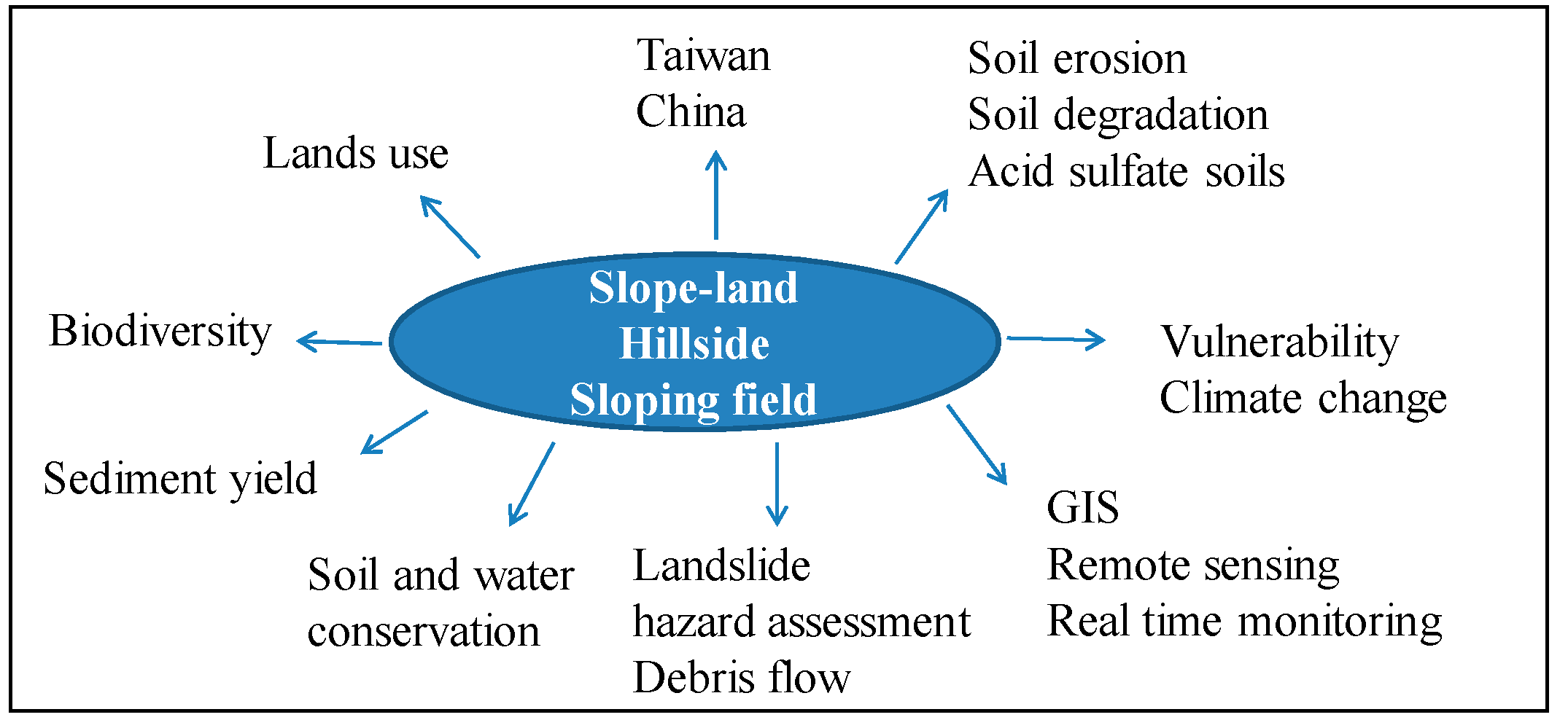
2.2.1. International Trend Analysis

International trend analysis is a tool for observing, predicting, and comparing global technology and industry development trends through scientific calculation to discover emerging technological opportunities [28]; this tool was applied for international document database searching [29]. Foreign research and documents related to the SWC of slope-land were filtered using “slope-land”, “hillside”, and “sloping field” as keywords (Figure 1) in AuthorMapper searches. The foresight technology strategies of other countries were also investigated. For a domestic trend analysis, the literature review method [30] was adopted, and information on 264 SWC projects executed by the Soil and Water Conservation Bureau from 2007 to 2012 was collected and reviewed. Keywords such as “watershed management”, “ecological engineering method”, “disaster reduction and prevention”, and “monitoring and prevention of debris flows” were applied to further identify problems of conservation and management of Taiwanese slope-land from 2009 to 2015; these keywords were applied in an attempt to distinguish the factors of slope-land conservation from one another and to facilitate contemplating future development caused by global socioeconomic demands and developing trends. The outcomes were used as the background information for the focus group analysis [31,32] to grasp the current foreign and domestic SWC situation and to further identify SWC issues.
Figure 1. Keywords for slope-land.
Sustainability 08 00053 g001

2.2.2. Focus Group

Using a focus group is a qualitative research method. Typically, 6 to 12 participants are involved when this method is employed, and these participants are allowed to engage in free and interactive discussions regarding a specific topic. The discussions can generate simultaneous conversations, reflective thinking, knowledge sharing, and even the discovery of new turning points [33]. According to this method, the present study reviewed the current development of soil and water resources in Taiwan, and during the discussions and conversations, it facilitated exploring the plans for future growth and resolutions. Some advantages of the focus group method are as follows: (a) the study materials provided are consistent with reality; (b) the results are easy to interpret; (c) information can be gathered quickly; and (d) it offers the opportunity for flexible discussions and feedback [34].
On the basis of the results of the international trend analysis, the focus group analyzed the impact of extreme climate and socioeconomic change on slope-land in Taiwan. In accordance with a compilation of SWC data and references from the IPCC AR5, profile setting, land use, and climate and socioeconomic change were established as background information for the focus group. Experts from a variety of fields, including SWC, environmental protection, hydraulic engineering, water conservation, agricultural chemistry, earth science, geology, mining, soil, and disaster prevention, were invited to prevent narrow conclusions from being reached, which usually occurs when experts with similar backgrounds engage in discussions, as in traditional focus groups [35]. After the first expert seminar, 28 issues related to the SWC of slope-land were summarized and used to design the Delphi questionnaire. The second expert seminar was held after two rounds of Delphi questionnaires, and it determined multiple stakeholder expectations, goals, and strategies regarding the soil and water resources of slope-land in Taiwan, which were used as a reference for the strategy roadmap.

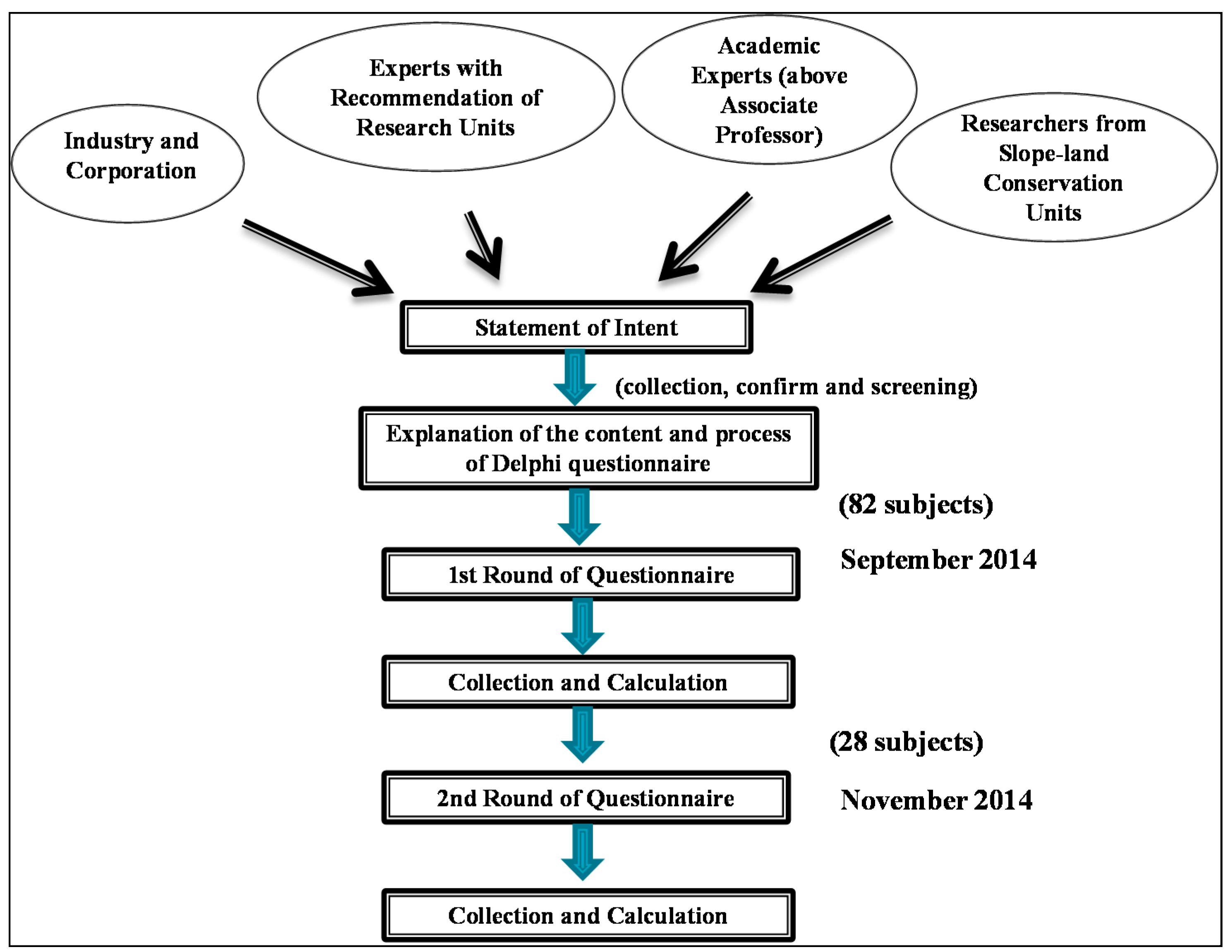
2.2.3. Delphi Method

This was a social science study. The Delphi method is widely applied [36] because of its anonymity, which enables each expert to provide his or her own judgment freely. The process involves two rounds of feedback. The experts can refer to the statistical results of the first round to answer the questions in the second round; by doing so, they can gradually reach a consensus [28]. This is the standard procedure of the Delphi method. Participants remain anonymous during the process to encourage free expression of opinions, which is essential for a qualitative analysis method. The facilitator collects various opinions and delivers them to each participant to encourage interaction between them to achieve an ultimate consensus on the topic [37]. This study applied a method similar to the Delphi method and recorded the opinions of multiple stakeholders. Under the Delphi method, the number of participants and content of questionnaires is typically maintained between rounds [38,39], whereas in this study, only those who provided in-depth answers were allowed to join the second round. Experts that joined in the second round were requested to complete the questionnaire according to the results (average values) of the first round. Once participants finished the two rounds of questionnaires, their questionnaires were considered effective. This process was performed to encourage a panel of experts to form a consensus on certain issues [40].
The current environmental policy goal of Taiwan is to promote the sustainable development of soil and water resources regarding life, production, and ecology. Accordingly, the design of the questionnaire focused on experts’ familiarity with relevant issues (considering the cross-field nature of the issues), their prioritization of the issues, and the influence on their valuation of the aforementioned aspects of life, production, and ecology. The life aspect referred to safe and secure public living; the production aspect represented the influence on the national industrial economy; and the ecology aspect referred to the biodiversity in nature. There were 28 issues covered by the Delphi questionnaire, and each issue was investigated using five questions. In the first round, experts answered the questions regarding (a) their familiarity with relevant issues (as a reference for weight distribution); (b) their prioritization of environmental issues in Taiwan; (c) the influence of the issues on national living quality; (d) the effect of the issues on the ecological environment; and (e) the influence of the issues on related industries. An effective questionnaire required that 80% of questions were answered in each round and that the results demonstrated the differences between various questions. Because an expert may be unfamiliar with issues other than those in his or her area of expertise, the questionnaire provided background information on the 28 issues in this study as references, which were the results from the international trend analysis and the first round of focus group questions. Familiarity was used to determine weight distribution [41]. Because the expert opinions were connected with the production of the subsequent issues and strategy roadmap, the selection of experts was crucial. The experts comprised SWC experts among industrial, governmental, and academic fields in Taiwan. Those who taught in the areas of domestic soil and water resource technology and were at least associate professors were considered academic experts, and they provided relatively innovative ideas. Governmental experts were Soil and Water Conservation Bureau members who were recommended internally and had experience in policy planning. Industrial experts were volunteers recruited from SWC associations. A simulation of the Delphi questionnaire used in this study is shown in Figure 2. Its results can provide policy-makers with information on short-term, middle-term, and long-term countermeasures against the threat posed by the extreme climate and socioeconomic change to the slope-land in Taiwan to mitigate the impact of this change [42].
Figure 2. Process of Delphi questionnaire.
Sustainability 08 00053 g002

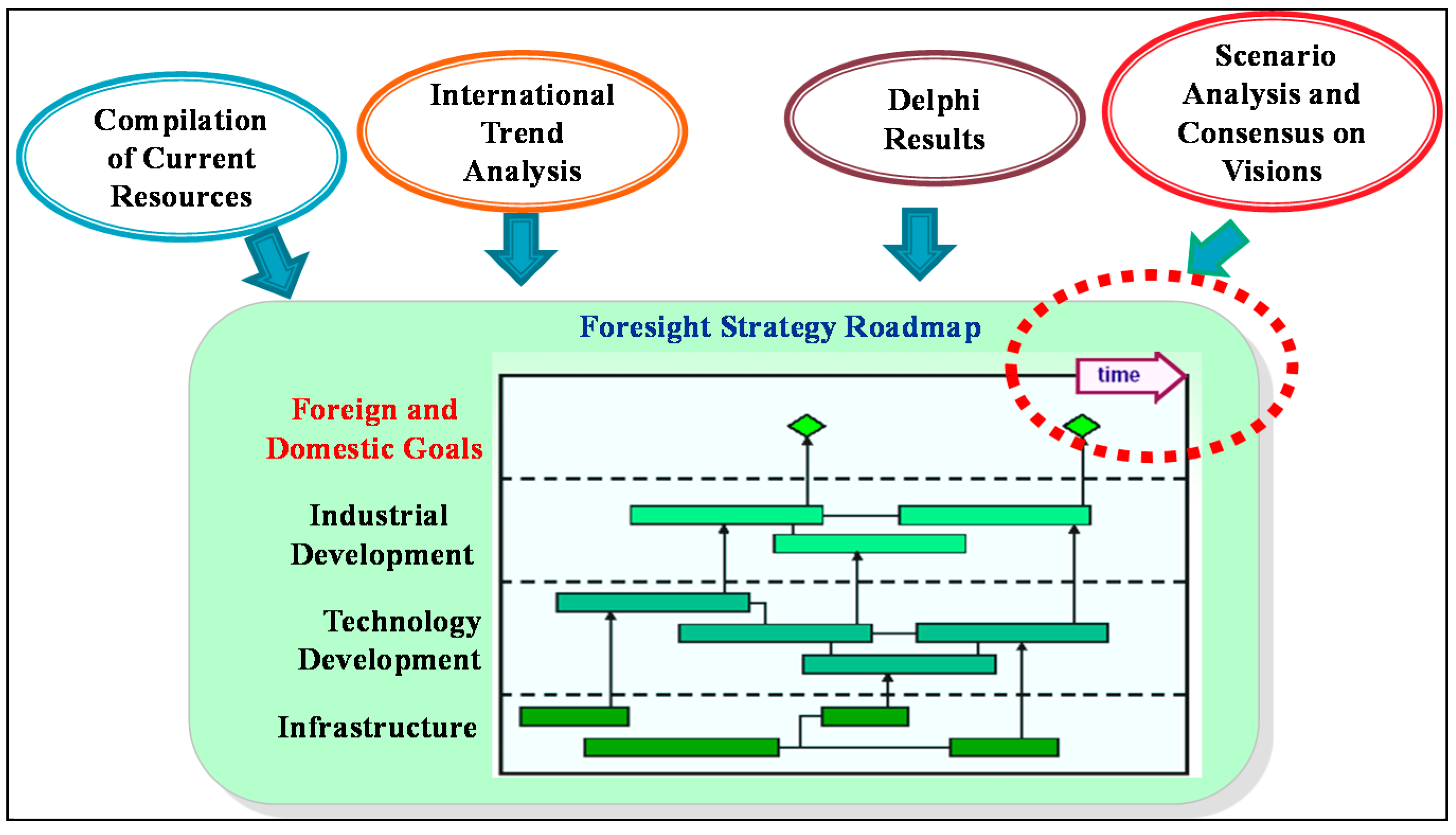
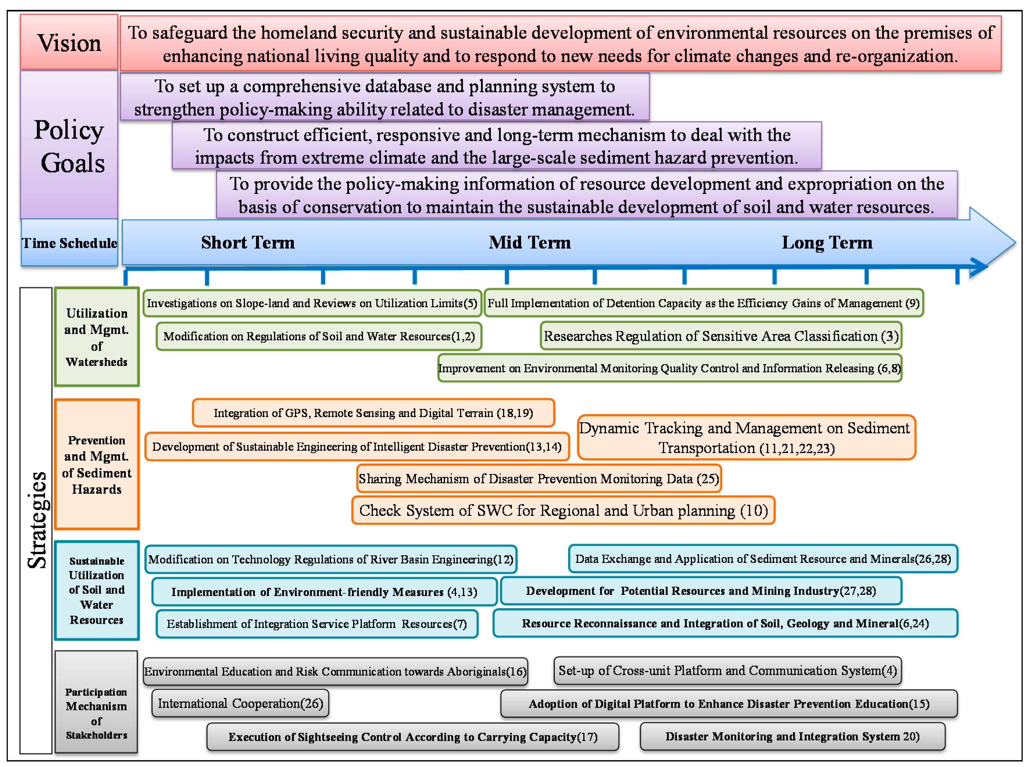
2.2.4. Strategy Roadmap

A strategy roadmap is a semi-quantitative analysis that was proposed by Professor Robert S. Kaplan of the Harvard Business School and Dr. David P. Norton of the Balanced Scorecard Collaborative. They reasoned that an enterprise could develop its most competitive strategy on the basis of its own characteristics and that all the employees could work together to follow the strategy [43]. A strategy roadmap involves logical connections between strategies, also called a “strategy portfolio”, which enable it to be seen as “the route of actions to achieve certain value propositions” (Figure 3). The benefits that a strategy roadmap provides are as follows: (a) integrated technology for delivering foresight and diversified messages; (b) visualization of a strategy; (c) a communication tool for opinion-exchanging and information understanding among multiple stakeholders; (d) the prioritization of foresight issues; (e) control of middle-term and long-term technology development trends; and (f) support for policy-makers to identify key directions [44]. Consequently, this study combined the goal of developing soil and water resources, basic priorities, and a compilation of research resources as well as evaluating and generating foresight issues with an execution schedule into a strategy roadmap to facilitate policy-makers easily grasping the overall resource distribution situation. The purpose of this method was to develop resource distribution priorities and strategies.
Figure 3. Strategy roadmap of this study.
Sustainability 08 00053 g003

2.2.5. Eisenhower Matrix

The Eisenhower Matrix was created by U.S. President Dwight D. Eisenhower. He used this matrix to prioritize his tasks. Also known as a Priority Matrix, it can help decision-makers separate tasks into four categories according to priority and urgency. It was adopted in this study to prioritize the strategies [14]. To categorize the priorities of the middle-term and long-term countermeasure strategies on the strategy roadmap, this study separated the Eisenhower Matrix on the basis of the average maximum and minimum values for the strategies, as plotted on X- and Y-axes. In other words, the average values for the strategies, as plotted on the X- and Y-axes, were taken as the coordinates to divide the matrix into the four quadrants. The first quadrant represented the first priority, which was followed by the second quadrant and the fourth quadrant; the third quadrant was last. The stakeholders could adjust the orders of the strategy roadmap according to this matrix.

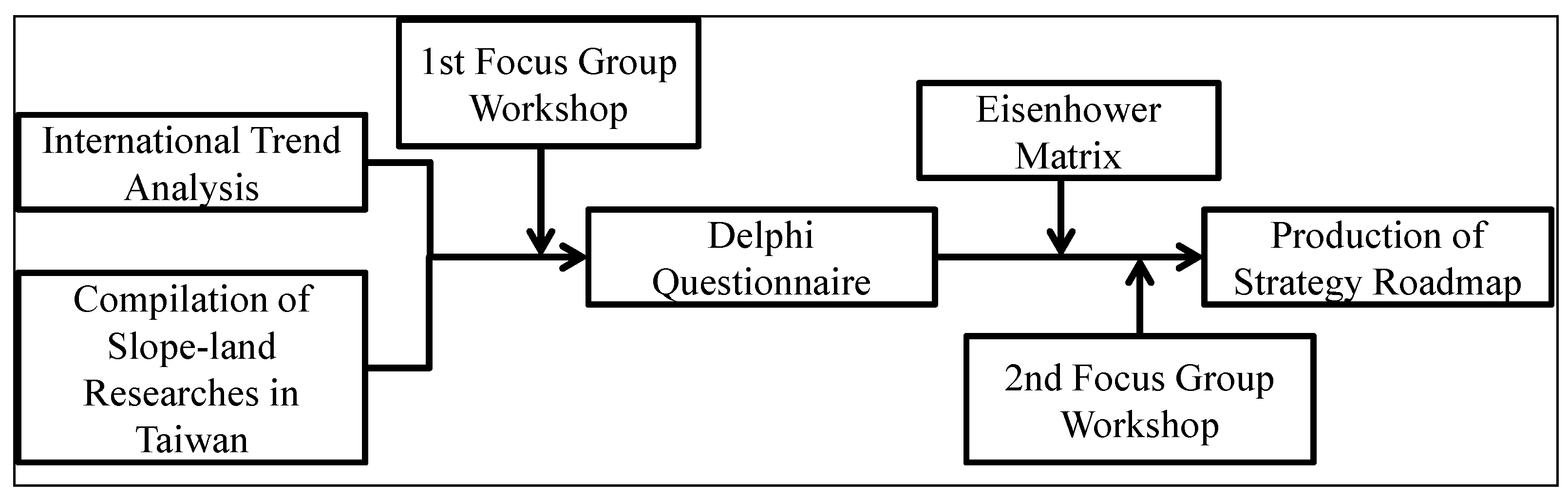
2.3. Study Structure

For this study, a keyword-search of the materials and research projects of the international trend analysis and the Taiwanese SWC management unit of slope-land was conducted to identify the current situation and potential future environmental deterioration (see Figure 4). With the compilation of related data, the first focus group was held, which resulted in 28 foresight issues concerning current challenges and corresponding scenarios. According to these issues, two Delphi questionnaire rounds were completed, and the results were collected and analyzed. The Eisenhower Matrix was then used to prioritize the issues. Moreover, to consolidate the Delphi questionnaire surveys and to generate an objective strategy roadmap [45], the second focus group was held to reach the second stage of consensus among multiple stakeholders. Finally, the strategy roadmap was produced.
Figure 4. Process of research.
Sustainability 08 00053 g004

3. Results and Discussion

3.1. International Trend and Status Quo in Taiwan

According to the results of the international trend analysis, the concerns involving slope-land included farmland use, biodiversity, soil degradation, vulnerability and adaptation to climate change, SWC, landslides, delimitation of dangerous zones, debris flow, and geographic information systems. According to an examination of the volume of documents issued globally from 2012 to 2015, most of the results were from the United States, followed by China and Germany. Furthermore, environmental management, earth science, geography, geology, mining, ecology, and civil engineering were the essential background fields regarding soil and water resource use.
Climate change very likely causes severe global effects, which are very likely to affect Taiwan. The main purpose of reducing the concentration of greenhouse gases (GHGs) is to lower carbon dioxide emissions. Reducing GHG emissions reduces the risk of impact from extreme climate events. The budgets for SWC projects were USD15 million in 2007, USD16.18 million in 2008, USD31.13 million in 2009, USD24.05 million in 2010, USD22.76 million in 2011, and USD22.28 million in 2012. The implementation area of these projects extended throughout Taiwan. The result of the trend analysis was divided into four fields.

3.1.1. Slope-Land Conservation and Recovery

A total of 57 research projects for green technology were being executed, including vegetation projects, green-environment construction, green material development, and habitat conservation. In 2008, e-technology was applied to a slope-land management and prevention monitoring system to develop an information platform. In 2009, a GIS was developed on the basis of the information platform to benefit field investigation. In 2011, remote sensing technology was applied as an investigative tool for slope-land use, and a multiscale remote sensing geospacial information system was approved to consolidate coverage and other developments. Starting in 2012, focus was placed on establishing a disaster catalog and ecosystem conservation database and on promoting and educating others about slope-land conservation and disaster prevention.

3.1.2. Slope-Land Disaster Prevention

The slope-land disaster prevention program involved 109 landslide prevention projects and used monitoring and preventive measures to cover high-risk areas. Especially after Typhoon Morakot in 2009, research and prevention projects related to debris flow and large-scale landslides have been extensively increased. Various studies on extremely heavy rain caused by climate change have been carried out, and the risks of sediment hazards have been reexamined. Additionally, countless monitoring and remote sensing techniques have been developed and integrated using the aforementioned information platform. Moreover, a dynamic management review was performed on autonomous prevention mechanisms of slope-land communities for further improving prevention programs.

3.1.3. Watershed Management and Recovery

The analysis indicated that the 58 projects covering treatment engineering, watershed investigation and planning, and improvement of geological survey techniques focused more on soft design research in SWC engineering. However, since 2012, environmentally friendly research with ecosystem conservation has been the highest priority.

3.1.4. Torrent Investigation and Planning

A total of 40 projects associated with ecological engineering, research on torrent treatment, and regulation of flood-prone areas were implemented. The investigation and planning of ecological conservation has been the focus of torrent erosion and sediment control in the past. However, the frequency of rainfall with high recurrence intervals has recently increased, causing the focus of projects to shift to disaster prevention. These projects include the investigation of potential debris flow torrent, water-disaster prevention and control of river basins, and torrent dredging engineering.
Both foreign and domestic data were collected and analyzed to review the technology development and measures related to sustainable soil and water resources in Taiwan. Furthermore, key points released by the IPCC AR5 were used to contemplate the possible goals, which could link SWC in Taiwan to international issues. The results demonstrated that when the environment is under pressure from extreme climate and socioeconomic change, the impact (extreme precipitation) on slope-land increases and the carrying capacity of slope-land (potential for land use) decreases. This is an urgent challenge for slope-land SWC in Taiwan. The future scenario analysis is shown in Table 1.
Table 1. Future scenario analysis of environmental stress for slope-land in Taiwan.
Driving FactorScenarios and Goals
Extreme ClimateThe changes of rain types and the higher frequency of extreme climate lead to the severity of floods and droughts, sediment hazards, reservoir sedimentation, and increasing temperature. It further results in crop production on slope-land, high demands of water, water contamination in watersheds and deterioration of habitats. The goal shall be mitigation and adaptation on climate change.
Socio-economic ChangesDue to socio-economic influences, such as aging society, falling birth rate and wealth inequality, the traditional slope-land agriculture is commonly shifted for leisure and recreational use. The goal shall be introducing green industry for SWC, recovery and sustainable use.

3.2. Vision and Functional Positioning of Slope-Land Development

A total of 40 experts from industries, governmental units, and academic institutions related to the SWC of Taiwanese slope-land were screened regarding international trends and whether their research focused on a status quo analysis in Taiwan. They were the multiple stakeholders in this study. The focus group method was executed to examine the urgent problems of slope-land and to reach a consensus on the sustainable utilization of soil and water resources. The experts agreed that the vision of slope-land conservation in Taiwan is as follows: “regarding climate and socioeconomic change, based on multiple uses to manage watershed resources to avoid disasters and sustain SWC”. The core priorities were as follows: (a) establishing a comprehensive database and investigation system for mastering the resources of water and soil to provide the infrastructure of disaster prediction and the foundation for policy-making on resource utilization; (b) constructing efficient, responsive, timely, and long-term mechanisms in accordance with environmental trends and the characteristics of potential disasters; and (c) determining how to apply the environmental information to policy-making regarding slope-land development and conservation.
For specialization and integration, the experts all stated that the challenges from climate change and socioeconomic deterioration should be seriously considered and that the corresponding improvements should be understandable and accessible to the public. Consistent with this concept, it is necessary to develop an environmental database covering land use, water resource management, sediment management, and sustainable environmental maintenance as a reference for policy-making for disaster prevention and conservation of slope-land. For land use, this database should apply the concept of national spatial planning to integrate the current geological information and use it as the foundation for managing different developing projects, such as development, sensitive, and non-sensitive areas. For water resource management, the river basins should be considered in their entirety for policy-planning management. For business execution, the watersheds can be understood as management units. For sediment management, the big data of environmental resources can be used to determine the geologically sensitive areas and mineral locations. During engineering projects, useful minerals can be used to increase the added value of sediments. For maintaining a sustainable environment, focusing on the aspect of “safety and sustainability” for future slope-land resources, policies and legal concurrence (e.g., the Geology Act, the Soil, Sand, Gravel, and Rock Exploitation Law, the Forest Act, and the Water Resource Act) should be considered as a means of strengthening the regulations and systems. A long-term and stable information system should be established, and information releases and explanations should be provided. In-depth education on slope-land environments and risk communications could ease the doubts and arguments among the public. Thus, the focus group in this study analyzed nine key aspects, including regulations, talent training, innovative technology, new engineering, and industrial development, and 28 foresight issues (Table 2) for the benefit of future policy execution.
Table 2. 28 Foresight issues for sustainable utilization of soil and water resources.
CategoryForesight Issues
Regulation Reviews and Modifications(SWC Act, Geology Act, Mining Law)
1.
To review the regulations related to soil and water resources and to modify and strengthen contents for legal concurrence in order to minimum the difficulty of development and conservation on slope-land in watersheds.
2.
To review and modify the related regulations to enhance the sustainability of sediments and underground water.
3.
To conduct researches on land expropriation and regulations to locate sensitive zones and reinforce the conservation.
4.
To establish a platform across units to carry out communications and management systems among each unit and stakeholders for facilitating watershed management.
Establishment and Integration of Environmental Database
5.
To re-investigate developed slope-land for clarifying the utilization limit in order to rationalize slope-land use.
6.
To integrate different data and resource reconnaissance on soil, geology, and minerals for disaster reading and reactions.
7.
To set up an integration platform of sediment resources, including technology information worldwide, to level up the efficiency of disaster reactions.
8.
To strengthen the quality control on environmental monitoring information and to lay down information-releasing policy to benefit the categorization of geological sensitive areas and the rationalization of land use.
Quantitative Evaluation and Control of SWC and Management
9.
To combine the detention function into the efficiency gains of slope-land management to enhance the capacity of water storage and to decrease the occurrence of flooding.
10.
To strengthen the check system of SWC for regional and urban planning to avoid disasters in urban areas.
11.
To conduct quantitative evaluation on sediment production on slope-land and to adopt dynamic tracking and management to control sediment transportation for increasing the efficiency of conservation engineering.
Environment-friendly Engineering
12.
To integrate and modify regulations of engineering technology on upstream, mid-stream and downstream to facilitate river-basin management.
13.
To establish a mechanism for new technology of SWC to improve the technology development and to ensure safety of the public.
14.
To develop the sustainable engineering concept and methods related to recovery and support after disasters in order to escalate the recovery speed and disaster prevention.
Establishment of Public Engagement Mechanism
15.
To enhance public educations on conservation and disaster prevention and to set up digital information platform for strengthening concepts.
16.
To intensify aboriginals’ educations on slope-land environment and risk communication to safeguard their villages and living welfare.
17.
Considering the carrying capacity and resistance capacity in mountain areas, to implement controls on mountain sight-seeing for the sake of minimizing environmental damages and increasing the odds for live-saving.
Disaster Prevention Monitoring and Technology Application
18.
To integrate systems of GPS, remote sensing and digital terrain to enhance the monitoring capacity of watersheds for controlling in-time characteristics of each area.
19.
To employ cloud technology to strengthen collection and analysis of monitoring data and the policy-making ability to further increase the prevention efficiency.
20.
To build up a disaster monitoring mechanism at the departmental level to execute the comprehensive business planning.
Planning and Talent-training
21.
To reinforce human resources and evaluation tools for investigations on sediment resources and sensitive areas to improve evaluation accuracy.
22.
To deploy talents for project teams to execute prevention tasks (such as removing fragile sediments and clearing potential collapse areas by mining engineering method) and to train the people with planning and thinking skills.
Disaster Management and Preparation
23.
To strengthen the cleaning and re-use of sediments after disasters to achieve the sustainability of sediment resources.
24.
To enhance the integration capacity of horizontal application on various data to develop the system of disaster dynamic information and to increase the response ability.
25.
To set up a sharing mechanism of satellite images, soil and water resources and other disaster prevention data for accelerate monitoring and early warning capacity.
Development of Mining Industry
26.
To facilitate information exchanges and value-added application concerning to international mining industry and sediment resources for sustainable development of minerals, such as participating in international economic and trade meetings on mining industry.
27.
To research and develop potential resource for the possibility of minerals.
28.
To take advantage of current minerals and high-tech industry to increase the added values of domestic minerals and industrial competitiveness.

3.3. Delphi Questionnaire to Determine Sustainable Utilization of Soil and Water Resources

The Delphi questionnaire is a questionnaire survey conducted in two rounds that aims to converge opinions from a panel of experts. There were 28 questions in the questionnaire in this study. An effective questionnaire required that 80% of questions were answered in each round and that the results demonstrated the differences between various questions. Because an expert may be unfamiliar with issues outside of his or her expertise, the questionnaire provided background information on the 28 issues as references. Furthermore, the familiarity of experts with issues was used to determine the weight distribution of the results.
This study required three months for completing the two rounds of surveys. In the first round, 147 experts from industries, governmental units, and academic institutions agreed to act as subjects. A total of 82 questionnaires were answered, with the response rate being 55%. A total of 69 experts completed the questionnaires online, accounting for 84% of the questionnaires answered. In the second round, the 28 remaining experts, who were recommended by the Soil and Water Conservation Bureau, participated. They completed the questionnaires on the basis of the results from the first round for the purpose of convergence. There were 28 issues in this survey, and each issue was investigated using five questions. In the first round, experts answered the questions on their familiarity with related issues, their prioritization of environmental issues for Taiwan, the influence of the issues on national living quality, the effect of the issues on the ecological environment, and the influence of the issues on related industries. Experts in the second round were requested to answer the questionnaires according to the results of the first round.
To facilitate an understanding of the prioritization of the 28 issues by these experts, other than familiarity, the top 10 issues for each question are listed in Table 3. Five issues ranked in the top 10 concerning the four aforementioned questions, namely Issues 1, 2, 5, 6 and 8. This demonstrated that these issues were more highly prioritized.
Table 3. Top 10 issues from 1st-round investigation.
RankImportance to TaiwanInfluence on National Living QualityInfluence on Ecological EnvironmentInfluence on Related Industries
1Issue 18Issue 5Issue 5Issue 5
2Issue 20Issue 10Issue 3Issue 8
3Issue 15Issue 2Issue 2Issue 18
4Issue 25Issue 15Issue 9Issue 23
5Issue 6Issue 8Issue 17Issue 2
6Issue 5Issue 9Issue 1Issue 6
7Issue 8Issue 3Issue 6Issue 3
8Issue 2Issue 1Issue 8Issue 17
9Issue 10Issue 6Issue 18Issue 25
10Issue 1Issue 25Issue 15Issue 1
To centralize the questions in the second round, this study observed the connections between each index and the priority of the issues by using an index cross-analysis. The results demonstrated that three indexes, namely national living quality, ecological environmental protection, and industrial development, positively correlated with the priority of the issues, with coefficients of 0.87, 0.76, and 0.72, respectively. The index of national living quality had the highest coefficient of the three, indicating that the sustainable utilization of soil and water resources should be based on accessibility and property security. Consequently, the questionnaire for the second round was designed to focus on the priority of the issues regarding Taiwan, their influence on national living quality, and suggestions for countermeasures in the pursuit of a consensus on policy implementation. A total of 28 questionnaires were answered, with a response rate of 100%. During the analysis, a statistical method was used to highlight the differences in responses. The scores were defined as follows: 20 points for “the lowest”, 40 points for “low”, 60 points for “fair”, 80 points for “high” and 100 points for “the highest”. Moreover, weighting was included to enhance the accuracy of the results. The familiarity of experts was weighted, starting from 0.5 for “the lowest”, 0.75 for “low”, 1 for “medium”, 1.25 for “high” and 1.5 for “the highest”. The questionnaires were weighted and calculated for their average values. Table 4 reveals the average values and standard deviations of each issue. The top 10 answers from the second round are listed in Table 5.

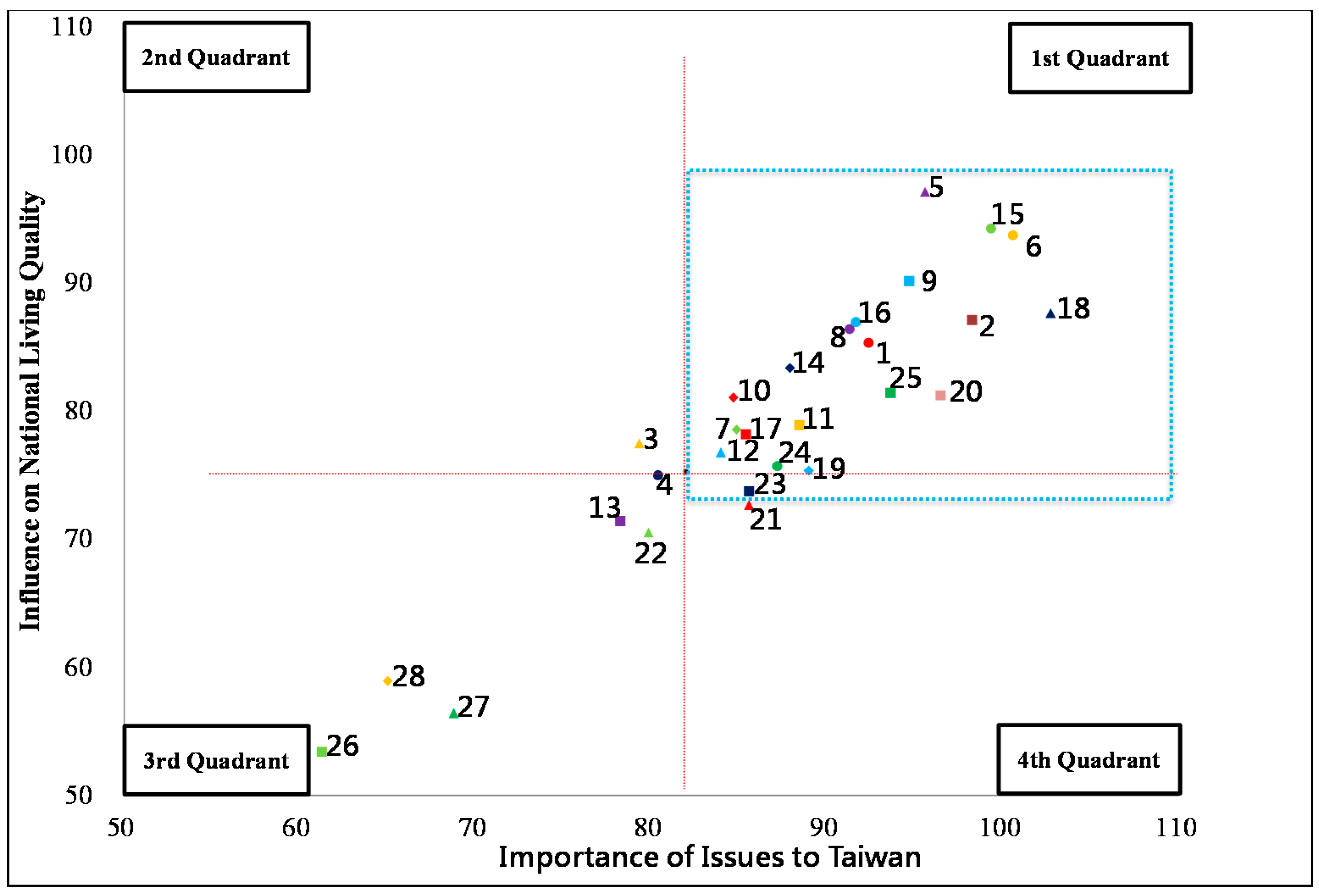
3.4. Strategy Roadmap of Foresight Issues

To prioritize the short-term, middle-term, and long-term strategies on the strategy roadmap, the Eisenhower Matrix was used to arrange the order of issues. The two axes of the matrix represented the “Influence on National Living Quality” and “Priority of Issues”, and the four quadrants were subsequently divided. The first quadrant indicated that an issue was highly prioritized and that the national living quality could be largely improved once the issue was addressed. The issues in this quadrant were considered to be first priority strategies on a “short-term” basis. If the value of an issue was high on only one axis, then the issue was placed in the second or fourth quadrant and listed as a “middle-term” strategy. Being in the third quadrant meant that the priority and influence of an issue were both low and that they were “long-term” strategies. In accordance with the results of the second round Delphi questionnaire, the average value of the “Importance to Taiwan” was indicated on the X-axis, whereas the average value of the “Influence on National Living Quality” was indicated on the Y-axis. A coordinate map was then produced, as shown in Figure 5. At this stage, the Eisenhower Matrix was applied to prioritize the 28 issues for short-, middle-, and long-term periods.
Table 4. Statistics from 2nd-round.
IssueImportance of Issues to TaiwanInfluence on National Living Quality
AverageStandard DeviationAverageStandard Deviation
Issue 192.3224.0285.3625.67
Issue 298.2126.0487.1423.39
Issue 379.2924.7577.5026.99
Issue 480.3626.2875.0025.78
Issue 595.5426.9997.1427.60
Issue 6100.5423.8693.7524.52
Issue 784.8226.9678.5728.77
Issue 891.2530.3686.4328.93
Issue 994.6429.4490.1828.79
Issue 1084.6427.3281.0723.23
Issue 1188.3928.7778.9323.31
Issue 1283.9329.9876.7929.67
Issue 1378.2129.0371.4325.71
Issue 1487.8625.6683.3923.88
Issue 1599.2924.8694.2923.75
Issue 1691.6124.3586.9622.91
Issue 1785.3632.4678.2134.43
Issue 18102.6822.3887.6824.93
Issue 1988.9328.3975.3625.85
Issue 2096.4328.4481.2528.86
Issue 2185.5424.8872.6822.50
Issue 2279.8231.4370.5430.20
Issue 2385.5427.4073.7527.64
Issue 2487.1421.6275.7128.18
Issue 2593.5726.7081.4328.31
Issue 2661.2527.4453.3929.28
Issue 2768.7534.7656.4333.55
Issue 2865.0033.1758.9333.18
Table 5. Top 10 issues from 2nd-round.
RankImportance of Issues to TaiwanInfluence on National Living Quality
1Issue 18Issue 5
2Issue 6Issue 15
3Issue 15Issue 6
4Issue 2Issue 9
5Issue 20Issue 18
6Issue 5Issue 2
7Issue 9Issue 16
8Issue 25Issue 8
9Issue 1Issue 1
10Issue 16Issue 14
Once their priorities were determined, the 28 issues were translated into the strategy roadmap. The order determined from the Eisenhower Matrix was considered the result of an objective analysis method. For the feasibility of actions, the amount of invested resources and expected policy concepts were required to be considered. Thus, the aforementioned analysis results are mainly provided for use as references by experts. The current primary strategy roadmap was proposed in the second round of the focus group. After discussions, the nine aspects of the 28 issues were integrated into four aspects. Some of the issues were also integrated and adjusted to redevelop the strategy roadmap. The final structure of the strategy roadmap incorporated visions, policy goals, time schedules, and strategies for execution (Figure 6).
Figure 5. Prioritization of the issues through Eisenhower matrix.
Sustainability 08 00053 g005
Figure 6. Strategy roadmap for sustainable utilization of soil and water resources. The number inside the brackets stands for the number of issues. The abbreviation of “SWC” stands for soil and water conservation.
Sustainability 08 00053 g006

4. Conclusions and Suggestion

While generating the strategy roadmap, the multiple stakeholders provided supportive measures for rule-making, information integration, talent-training, efficiency evaluation, and other management tasks to facilitate the consolidation of authority on slope-land policy in the future. Regarding reviews on regulations, clarification of the division of labor between authorities and units is required. Especially concerning legal concurrence, the original meanings of certain regulations require clarification for further examination. For basic information, because information is the foundation for management, developing a comprehensive database is crucial. The reorganization of this database would also provide an opportunity for integration. The establishment of a slope-land management governmental unit may facilitate the introduction of an updated database of national soil and water resources that is accessible to the public and includes different scales for disasters and information on the limitations and mechanisms of geological hazard-prone areas. Watersheds should be understood as management units for slope-land conservation in Taiwan, and their time schedule should be coordinated with a strategy for addressing extreme climate events. The strategy roadmap in this study suggested the following key strategies at each stage as references for policy-makers. The difference between short-term, middle-term, and long-term strategies is in the initiation time. In principle, a short-term strategy aims to improve public safety; a middle-term strategy aims to enhance ecological sustainability (including strategies for enhancing work performed in an earlier period); and a long-term strategy aims to intensify the industrial environment without overlooking public living and ecology (including strategies for enhancing work performed in an earlier period). For example, Issues 1 and 2 in Figure 6 are short-term strategies (because they concern public safety).
  • Short-term strategy: Its focus was on sediment adaptation strategy, disaster prevention, management of watershed sources, and improvement of water quality during extreme climate events. Because of socioeconomic change, the types of slope-land use have shifted. Thus, it is crucial to reinforce management of slope-land, to realize disaster prevention education, and to establish a platform for communications. The main task was to strengthen national living and property safety
  • Middle-term strategy: Its emphasis was on every issue of watershed operation management to recover and maintain the water conservation and purifying abilities of slope-land. Simultaneously, environmentally sensitive areas should be highlighted for conservation and management to pursue legislation promoting rational land control, reasonable use of resources, and strict management. This strategy aimed to provide a sustainable method for both living and ecological maintenance
  • Long-term strategy: Its focus was on national spatial planning, according to which this collection of issues could improve the legislative status of SWC and the extreme climate event countermeasures of processing and maintenance. With the introduction of low-impact development, e-governance, water conservation, and national spatial conservation, it could also ease the impact from land use on soil and water resources to ensure the environmental sustainability of the three aforementioned aspects of living, production, and ecology
This study provided a foresight SWC strategy according to experiences in Taiwan. The operation of the foresight technology portfolio could be considered as a reference for other small-island countries to be used for developing strategies for adapting to climate change to generate a strategy roadmap. This study discovered two driving factors, which were global-warming impact and socioeconomic change (increase of carbon emission and slope-land use), in Taiwan, and it predicted future problems and threats to watersheds, namely floods, droughts (water contamination), and sediment hazards, by using foresight strategic planning. Furthermore, it outlined possible resolutions or mitigation methods, which could be used as a decision-making reference for both present and precautionary issues by governments to ease the impact of extreme climate events and to guard public safety. As the governmental organization is remodeled and the international socioeconomic situation changes, the sustainable use of soil and water resources is likely to be highly prioritized by governments, industries, and academic communities. Applying foresight strategic planning tools enhances the likelihood of consensus between multiple stakeholders concerning the future development of strategies and increases the feasibility of achieving the ideal sustainability of soil and water resources. The technology of slope-land disaster prevention in Taiwan is one of the most effective within the Asia-Pacific zone. Under the system of democracy, new government policies are usually questioned by the people. Thus, it is more efficient to consider the government as similar to the service industry, which should create niches to drive the competitiveness of a country. A sound foresight policy-making system can assist in conducting long-term policy surveys and supporting policy-making. By regularly employing the focus group method with multiple stakeholders, the government could obtain advice and opinions from experts in different fields during the policy-making process to reduce problems that occur following the execution of policies and to increase policy-making quality. During the operation of the foresight mechanism, the greatest challenge is participant organization, such as ensuring the participation of experts and coordination among fields. In addition, performing the adjustments in accordance with policy change is another difficulty. In the future, actions must be modified to execute strategies, and regular expert meetings should be held to facilitate examinations and revisions to reach the ultimate goal of “considering climate and socioeconomic change, watershed resources being managed on a multiple-use basis to avoid disasters and to sustain SWC” can be realized by the year 2025.

Acknowledgments

We would like to express our sincere gratitude to Soil and Water Conservation Bureau, Council of Agriculture, Executive Yuan for providing research materials that greatly assisted this study. The materials are “Conservation Strategies Response to Climate Change for the Key Watersheds” and “Research Project on Foresight and Strategic Planning of Water and Soil Resources Sustainable Management”.

Author Contributions

Wen-Cheng Huang and Yi-Ying Lee conceived and designed the study; Yi-Ying Lee carried out questionnaire and analysis; Wen-Cheng Huang searched literature, analyzed questionnaire and statistics results and wrote the manuscript.

Conflicts of Interest

The authors declare no conflict of interest.

References

  1. Hapgood, M.A. Towards a scientific understanding of the risk from extreme space weather. Adv. Space Res. 2011, 47, 2059–2072. [Google Scholar] [CrossRef]
  2. Lu, Q.C.; Zhang, J.Y.; Peng, Z.R.; Rahman, A.B.M.S. Inter-city travel behaviour adaptation to extreme weather events. J. Transp. Geogr. 2014, 41, 148–153. [Google Scholar] [CrossRef]
  3. Grand Century Natural Disasters Homepage. Available online: http://www.epochtimes.com/b5/nf425.htm (accessed on 10 May 2015).
  4. Intergovernmental Panel on Climate Change (IPCC). Summary for policymakers. In Climate Change 2014: Impacts, Adaptation, and Vulnerability; Intergovernmental Panel on Climate Change: New York, NY, USA, 2014. [Google Scholar]
  5. Travis, W.R. Weather and climate extremes: Pacemakers of adaptation? Weather Clim. Extrem. 2014, 5–6, 29–39. [Google Scholar] [CrossRef]
  6. National Hurricane Center, National Climatic Data Center USA. Hurricane Katrina; National Hurricane Center, National Climatic Data Center USA: University Park, FL, USA, 2005.
  7. Oven, K.J.; Curtis, S.E.; Reaney, S.; Riva, M.; Stewart, M.G.; Ohlemüller, R.; Dunna, C.E.; Nodwell, S.; Dominelli, L.; Holdenf, R. Climate change and health and social care: Defining future hazard, vulnerability and risk for infrastructure systems supporting older people’s health care in England. Appl. Geogr. 2012, 33, 16–24. [Google Scholar] [CrossRef]
  8. United Nations Environment Programme (UNEP). 21 Issues for the 21st Century: Result of the UNEP Foresight Process on Emerging Environmental Issues. In UNEP 2012; United Nations Environment Programme: Nairobi, Kenya, 2012; p. 56. [Google Scholar]
  9. Executive Yuan (EY). The Project of Overall Forestry Conservancy and Disaster Prevention from 2013–2016; Executive Yuan: Taipei, Taiwan, 2012. [Google Scholar]
  10. Chen, Y.L. Report on Typhoon Morakot (0908) of 2009. Available online: http://photino.cwb.gov.tw/rdcweb/lib/cd/cd02tyrp/typ/2009/98_02_Morakot_0908.pdf (accessed on 6 January 2016). (In Chinese)
  11. Council of Agriculture (COA), Executive Yuan (EY). Outlook of Water Environmental Management Strategies in Asia; Executive Yuan, Council of Agriculture: Taipei, Taiwan, 2012. [Google Scholar]
  12. Soil and Water Conservation Bureau (SWCB), Council of Agriculture (COA), Executive Yuan (EY). Research Project on the Foresight and Strategic Planning of Water and Soil Resources Sustainable Management; Executive Yuan, Council of Agriculture, Soil and Water Conservation Bureau: Taipei, Taiwan, 2013. [Google Scholar]
  13. Luca, D.B.; Jiri, K. The Environmental Performance Strategy Map: An integrated LCA approach to support the strategic decision-making process. J. Clean. Prod. 2009, 17, 900–906. [Google Scholar]
  14. Cook, C.N.; Inayatullah, S.; Burgman, M.A.; Sutherland, W.J.; Wintle, B.A. Strategic foresight: How planning for the unpredictable can improve environmental decision-making. Trends Ecol. Evol. 2014, 29, 531–541. [Google Scholar] [CrossRef] [PubMed]
  15. McDonald, S.L.; Gallagher, D.R. A Story About People and Porpoises: Consensus-Based Decision Making in the Shadow of Political Action. Environ. Manag. 2015, 56, 814–821. [Google Scholar] [CrossRef] [PubMed]
  16. Hill, R.; Davies, J.; Bohnet, I.C.; Robinson, C.J.; Maclean, K.; Pert, P.L. Collaboration mobilises institutions with scale-dependent comparative advantage in landscape-scale biodiversity conservation. Environ. Sci. Policy 2015, 51, 267–277. [Google Scholar] [CrossRef]
  17. Mees, H.L.P.; Driessen, P.P.J.; Runhaar, H.A.C. “Cool’’ governance of a ‘‘hot’’ climate issue: Public and private responsibilities for the protection of vulnerable citizens against extreme heat. Reg. Environ. Chang. 2015, 15, 1065–1079. [Google Scholar] [CrossRef]
  18. Roy, M.; Curry, R.; Ellisc, G. Spatial allocation of material flow analysis in residential developments: A case study of Kildare County, Ireland. J. Environ. Plan. Manag. 2015, 58, 1749–1769. [Google Scholar] [CrossRef]
  19. Schwerdtner, W.; Siebert, R.; Busse, M.; Freisinger, U.B. Regional Open Innovation Strategy roadmap: A New Framework for Innovation-Based Regional Development. Sustainability 2015, 7, 2301–2321. [Google Scholar] [CrossRef]
  20. Cook, C.N.; Wintle, B.C.; Aldrich, S.C.; Wintle, B.A. Using Strategic Foresight to Assess Conservation Opportunity. Conserv. Biol. 2015, 28, 1474–1483. [Google Scholar] [CrossRef] [PubMed]
  21. Raford, N. Online foresight platforms: Evidence for their impact on scenario planning & strategic foresight. Technol. Forecast. Soc. Chang. 2015, 97, 65–76. [Google Scholar]
  22. Al-Bakri, J.T.; Salahat, M.; Suleiman, A.; Suifan, M.; Hamdan, M.R.; Khresat, S.; Kandakji, T. Impact of Climate and Land Use Changes on Water and Food Security in Jordan: Implications for Transcending “The Tragedy of the Commons”. Sustainability 2013, 5, 724–748. [Google Scholar] [CrossRef]
  23. Lee, C.; Song, B.; Park, Y. An instrument for scenario-based technology roadmapping: How to assess the impacts of future changes on organisational plans. Technol. Forecast. Soc. Chang. 2015, 90, 285–301. [Google Scholar] [CrossRef]
  24. Mintzberg, H. Managing government—Governing management. Harv. Bus. Rev. 1996, 74, 75–83. [Google Scholar]
  25. Huang, L.; Zhang, Y.; Guo, Y.; Zhu, D.; Porter, A.L. Four dimensional Science and Technology planning: A new approach based on bibliometrics and technology strategy roadmap. Technol. Forecast. Soc. Chang. 2014, 81, 39–48. [Google Scholar] [CrossRef]
  26. Vishnevskiy, K.; Karasev, O.; Meissner, D. Integrated roadmaps and corporate foresight as tools of innovation management: The case of Russian companies. Technol. Forecast. Soc. Chang. 2015, 90, 433–443. [Google Scholar] [CrossRef]
  27. Graham, G.; Mehmood, R.; Coles, E. Exploring future cityscapes through urban logistics prototyping: A technical viewpoint. Supply Chain Manag. Int. J. 2015, 20, 237–248. [Google Scholar] [CrossRef]
  28. National Chengchi University (NCUC). Thinking of Policy Foresight; National Chengchi University: Taipei, Taiwan, 2010. [Google Scholar]
  29. Staffas, L.; Gustavsson, M.; McCormick, K. Strategies and Policies for the Bioeconomy and Bio-Based Economy: An Analysis of Official National Approaches. Sustainability 2013, 5, 2751–2769. [Google Scholar] [CrossRef]
  30. Carvalho, M.M.; Fleury, A.; Lopes, A.P. An overview of the literature on technology strategy roadmap (TRM): Contributions and trends. Technol. Forecast. Soc. Chang. 2013, 80, 1418–1437. [Google Scholar] [CrossRef]
  31. Leonidou, L.C.; Leonidou, C.N.; Palihawadana, D.; Hultman, M. Evaluating the green advertising practices of international firms: A trend analysis. Int. Mark. Rev. 2010, 28, 6–33. [Google Scholar] [CrossRef]
  32. Yenigun, K.; Ecer, R. Overlay mapping trend analysis technique and its application in Euphrates Basin, Turkey. Meteorol. Appl. 2013, 20, 427–438. [Google Scholar] [CrossRef]
  33. Wu, H.Y. Constructing a strategy map for banking institutions with key performance indicators of the balanced scorecard. Eval. Progr. Plan. 2012, 35, 303–320. [Google Scholar] [CrossRef] [PubMed]
  34. Spickermann, A.; Grienitz, V.; von der Gracht, H.A. Heading towards a multimodal city of the future? Multiple stakeholder scenarios for urban mobility. Technol. Forecast. Soc. Chang. 2013, 89, 201–221. [Google Scholar] [CrossRef]
  35. Wu, Q.S.; Lin, T.Y. New Dictionary of Education; Higher Education Culture Undertakings Ltd.: Taipei, Taiwan, 2005. [Google Scholar]
  36. Landeta, J. Current validity of the Delphi method in social sciences. Technol. Forecast. Soc. Chang. 2006, 73, 467–482. [Google Scholar] [CrossRef]
  37. Spickermann, A.; Zimmermann, M.; von der Gracht, H.A. Surface-and deep-level diversity in panel selection—Exploring diversity effects on response behaviour in foresigh. Technol. Forecast. Soc. Chang. 2013, 85, 105–120. [Google Scholar] [CrossRef]
  38. Gnatzy, T.; Warth, J.; von der Gracht, H.; Darkow, I.L. Validating an innovative real-time Delphi approach—A methodological comparison between real-time and conventional Delphi studies. Technol. Forecast. Soc. Chang. 2011, 78, 1681–1694. [Google Scholar] [CrossRef]
  39. Hung, C.Y.; Lee, W.Y.; Wang, D.S. Strategic foresight using a modified Delphi with end-user participation: A case study of the iPad’s impact on Taiwan’s PC ecosystem. Technol. Forecast. Soc. Chang. 2013, 80, 485–497. [Google Scholar] [CrossRef]
  40. Birko, S.; Dove, E.S.; Ozdemir, V. Evaluation of Nine Consensus Indices in Delphi Foresight Research and Their Dependency on Delphi Survey Characteristics: A Simulation Study and Debate on Delphi Design and Interpretation. PLoS ONE 2015. [Google Scholar] [CrossRef] [PubMed]
  41. Yoda, T. Perceptions of domain experts on impact of foresight on policy making: The case of Japan. Technol. Forecast. Soc. Chang. 2011, 78, 431–447. [Google Scholar] [CrossRef]
  42. Al-Saleh, Y.M.; Vidican, G.; Natarajan, L.; Theeyattuparampil, V.V. Carbon capture, utilisation and storage scenarios for the Gulf Cooperation Council region: A Delphi-based foresight study. Futures 2012, 44, 105–115. [Google Scholar] [CrossRef]
  43. Wu, Q.S.; Lin, T.Y. Education noun—Policy Management. Educ. Data Res. 2001, 41, 1–66. [Google Scholar]
  44. Phaal, R.; Farrukh, C.J.P.; Probert, D.R. Technology strategy roadmap—A planning framework for evolution and revolution. Technol. Forecast. Soc. Chang. 2004, 71, 5–26. [Google Scholar] [CrossRef]
  45. Ecken, P.; Gnatzy, T.; von der Gracht, H.A. Desirability bias in foresight: Consequences for decision quality based on Delphi results. Technol. Forecast. Soc. Chang. 2011, 78, 1654–1670. [Google Scholar] [CrossRef]

