Article

Assessment and Management of the Geomorphological Heritage of Monte Pindo (NW Spain): A Landscape as a Symbol of Identity

by
Manuela Costa-Casais
1,*,
María Isabel Caetano Alves
2,† and
Ramón Blanco-Chao
1,†
1
Department of Geography, Faculty of Geography and History, University of Santiago de Compostela, Praza da Universidade, 1, 15782 Santiago de Compostela, Spain
2
María Isabel Caetano Alves, Institute of Earth Sciences-ICT/UM/CCT, University of Minho, Campus de Gualtar, 4710-057 Braga, Portugal
*
Author to whom correspondence should be addressed.
These authors contributed equally to this work.
Sustainability 2015, 7(6), 7049-7085; https://doi.org/10.3390/su7067049
Submission received: 13 March 2015 / Revised: 4 May 2015 / Accepted: 21 May 2015 / Published: 2 June 2015
(This article belongs to the Special Issue Sustainable Management of Geomorphological Heritage)

Abstract

:
This study focuses on the granite mountain known as Monte Pindo (627 m above sea level) in the Autonomous Community of Galicia (NW Spain). This territory is included in the area classified as “Costa da Morte” in the “Politica de Ordenación Litoral” (POL) (Coastal Planning Policy) for the region of Galicia. This coastal unit, located between “Rías Baixas” and “Cape Fisterra” has great potential for demonstrating geological processes and its geomorphological heritage is characterized by a high degree of geodiversity of granite landforms. The main objective of our work is to assess the geomorphological heritage of the site, thus revealing its wide geodiversity. We shall analyze and highlight: its scientific value, developing an inventory of granite landforms; its educational valuel and its geotouristic potential. It must be ensured that the Administration understands that natural diversity is composed of both geodiversity and biodiversity. Only then will the sustainable management of Monte Pindo become possible by integrating natural and cultural heritage values. The goal is to ensure that Monte Pindo and its immediate surroundings become a geopark with the aim of promoting local development projects based on the conservation and valorization of its geological heritage.

Graphical Abstract

1. Introduction

The systematic study of geological heritage and geodiversity is relatively recent. In some countries, like Britain, it was pioneered in the mid-twentieth century, although in Spain and in most of Europe it was not truly recognized until the early twenty-first century. Over the last decade, a knowledge base, along with the legislation that this implicitly requires, has been built up worldwide in relation to the characterization, conservation and management of both geological heritage and geodiversity. During 2007, for the first time in the history of Spain, important laws were passed by the Spanish Parliament explicitly mentioning geological heritage and geodiversity. Law 5/2007 (National Parks Network) [1] incorporates a list of geological contexts that are most representative of Spanish geodiversity. Law 42/2007, 13 December 2007 (Natural Heritage and Biodiversity) [2], elaborates on the conservation and management of geological heritage and geodiversity and incorporates the list of geological frameworks identified for Spain under UNESCO’s Geosites Program. This includes the concepts of geodiversity and geological heritage. This law identifies the public administrations of Spain’s autonomous regions (communities) as the entities responsible for the preservation of natural heritage and states that geoheritage must be inventoried as Geosites (Lugares de Interés Geológico-LIG—Sites of Geological Interest). Law 45/2007 (Sustainable Development of Rural Environment) establishes that rural development plans must consider the conservation and sustainable use of archaeo-industrial and geological heritage [3]. In general, the new legislative framework referring to natural conservation, supposes that inventories and on-going studies of the state of conservation of geodiversity and geological heritage be carried out. There are a multitude of concepts and definitions in scientific literature concerning geodiversity, geological heritage, geosites, and geoconservation [4,5,6,7,8,9,10,11,12]. However, these concepts have often been misused and, even today, it is common to see them applied in quite unconventional ways [13]. Geodiversity is an important term for future geoheritage management strategies. It is modeled on the term biodiversity that today dominates the work of nature conservation. It describes a complexity of natural attributes on all levels and represents both opportunities and challenges for management strategies [14]. Geological interpretation is a strategy that aims to facilitate communication between different kinds of publics, aiding the promotion of their scientific culture and the generation of feelings of esteem and protection for geoheritage [15]. The identification and characterization of sites are decisive steps in any geoconservation strategy [13,16].
This study focuses on the granite mountain known as Monte Pindo in the Autonomous Community of Galicia (NW Spain). This territory is included in the area classified as “Costa da Morte” established in the Coastal Planning Policy (Politica de Ordenación Litoral—POL) for the region of Galicia [17]. This unit is located between the areas classified in the POL as “Rías Baixas’” and “Cape Fisterra”. Currently, Monte Pindo’s biotic values are partially protected. It is designated as SCI (Site of Community Interest) 1110008 Carnota-Monte Pindo, and is included in the Natura 2000 network as an area of special protection of natural values related to both its vegetation and birdlife (ZEPA). However, the abiotic values and geological heritage of this territory have been forgotten, and are, therefore, unprotected. It is necessary to urgently find a solution that protects both its biodiversity and geodiversity. There is an urgent need to accentuate the principle that natural diversity is composed of both geodiversity and biodiversity, and that proficient conservation requires a holistic approach that views nature as a complex interaction of biodiversity and geodiversity patterns and processes. This geo-ecological approach would encourage a shift away from conserving individual biotic species and abiotic landforms and viewing nature through a static, “balance of nature” lens, towards a holistic agenda aimed at conserving landscapes, acknowledging episodic disturbance and change as natural phenomena, recognizing the importance of ecological processes, and managing landscapes accordingly [18]. Understanding the links between geodiversity and biodiversity is particularly crucial for conservation management in dynamic environments where natural processes (e.g., floods, sediment transport and flow regimes) maintain habitat diversity and ecological functions. Consideration of geomorphological sensitivity is a vital part of working in sympathy with natural processes, in assessing natural hazards and implementing the sustainable management of ecosystems, particularly under future climate change scenarios [19]. There are many elements of geodiversity that do not have a particular scientific value but which are still important resources for education, tourism, or the cultural identity of their communities [13]. The momentum of heritage in the field of geomorphology does not depend on the landforms, but rather depends on the willingness of people to communicate and recognize the geomorphological heritage of their region [20]. Monte Pindo is also a symbol of identity with the landscape for both the local population and visitors from outside the area. This fact leads to the site being valued in different ways. Since ancient times, intellectuals have regarded Monte Pindo as the “Celtic Olympus” [21,22]. This identity with the landscape can be supported on a scientific level [23,24,25]. In this sense, an association has been set up by some members of the local population with the aim of protecting the landscape. This association (Asociación Monte Pindo Parque Natural—Monte Pindo Natural Park Association) is supported by other groups, political parties and researchers, who argue that Monte Pindo must be proclaimed a “Natural Park” in order to protect the landscape with the aim of ensuring its preservation for future generations [26]. In this context, the Administration is aware of the situation but stands by and refuses to give a definitive answer. Monte Pindo is characterized by its coastal geodiversity with a large number of potential geosites. Its privileged location on the coast between Cape Fisterra and Monte Louro and Lagoon, make it an area of special interest on both a natural and cultural level. In relation to cultural aspects, it can be said that Cape Finisterre is about a 90-km walk from Santiago de Compostela. There is a recent tradition for pilgrims to burn their clothes or boots at the end of their journey at the Cape. There are testimonies from several previous rituals from the twentieth century, but this habit dates from the 1990s when it related to the Camino de Santiago [27,28]. However, today it is prohibited to burn things in Cape Fisterra. This stretch of coast includes three SCIS (Cape Fisterra—SCI ES 111005 Costa da Morte; Carnota beach—SCI ES 1110008 Carnota-Monte Pindo; and Monte Louro and lagoon—SCI ES 1110012) and Miñarzos Marine Fishing Reserve located in Lira (Carnota) (Figure 1). The various levels of government do not agree on who should grant the site protection. Therefore, it is necessary to obtain recognition for the geological-geomorphological and cultural heritage interest of Monte Pindo and its immediate surroundings as a Geopark (Cape Fisterra, Carnota beach, Monte Louro and lagoon and Miñarzos Marine Fishing Reserve). Obtaining this status would help to promote a local development project based on the conservation and valorization of the site’s terrestrial and maritime geological heritage [12]. Based on the conservation of natural and cultural assets and on the promotion of education and geotourism, geoparks are tools designed to promote the sustainable development of local populations. The geological interpretation is a key factor for the proper management of geosites, mainly in geoparks and protected areas [13].
Figure 1. Location of the area of study with the protected areas cited in the text.
Sustainability 07 07049 g001
The main objective of our work is to assess the geomorphological heritage of Monte Pindo, thus revealing its wide geodiversity and its landforms. This study aims to demonstrate the importance and interest of its granite landscape in the hope that will be recognized as an area, containing a high number of potential geosites. We will analyze and highlight: its scientific value; its educational value and its geotouristic potential in order to promote its preservation as Geological Heritage, that is to say, its Geoconservation [13,16,29,30]. The goal is to ensure that Monte Pindo and its immediate surroundings obtain the status of Geopark with the objective of promoting a local development project based on the conservation and valorization of its geological heritage.

2. Material and Methods

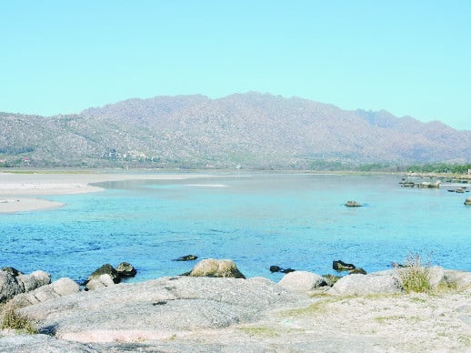
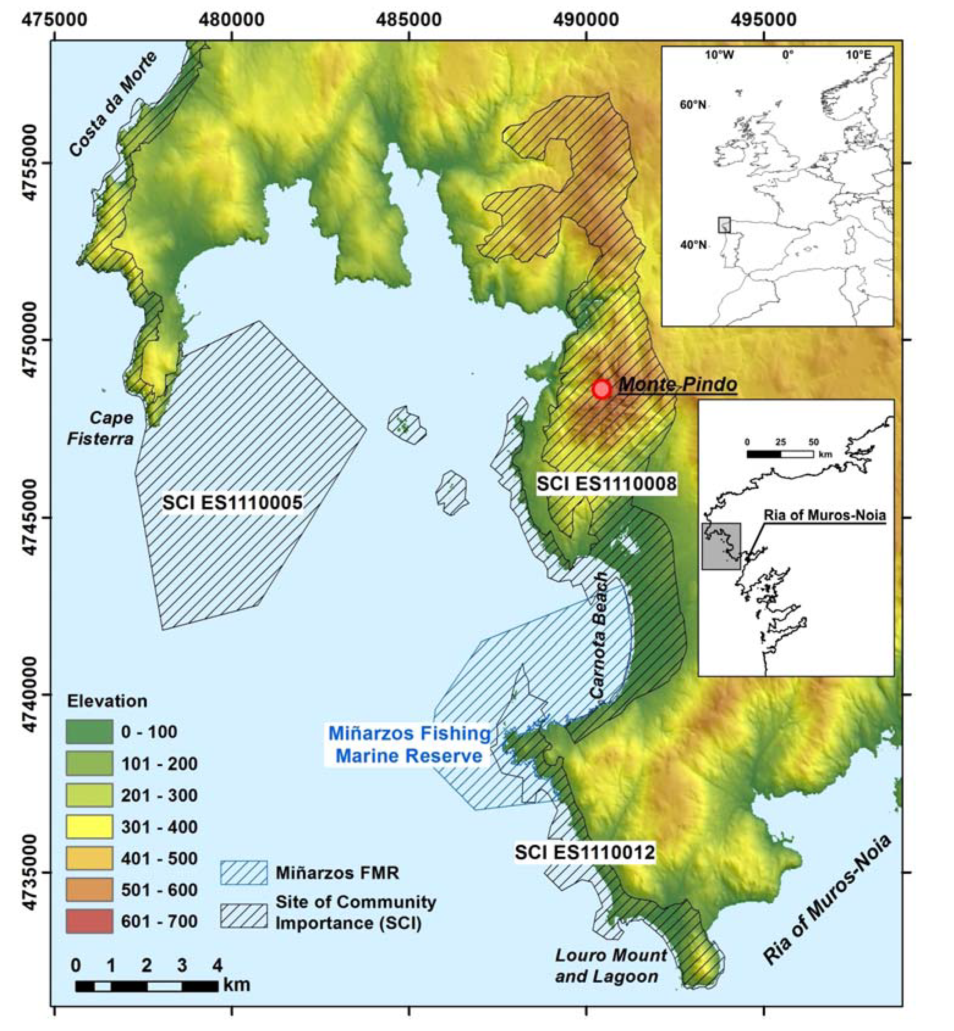
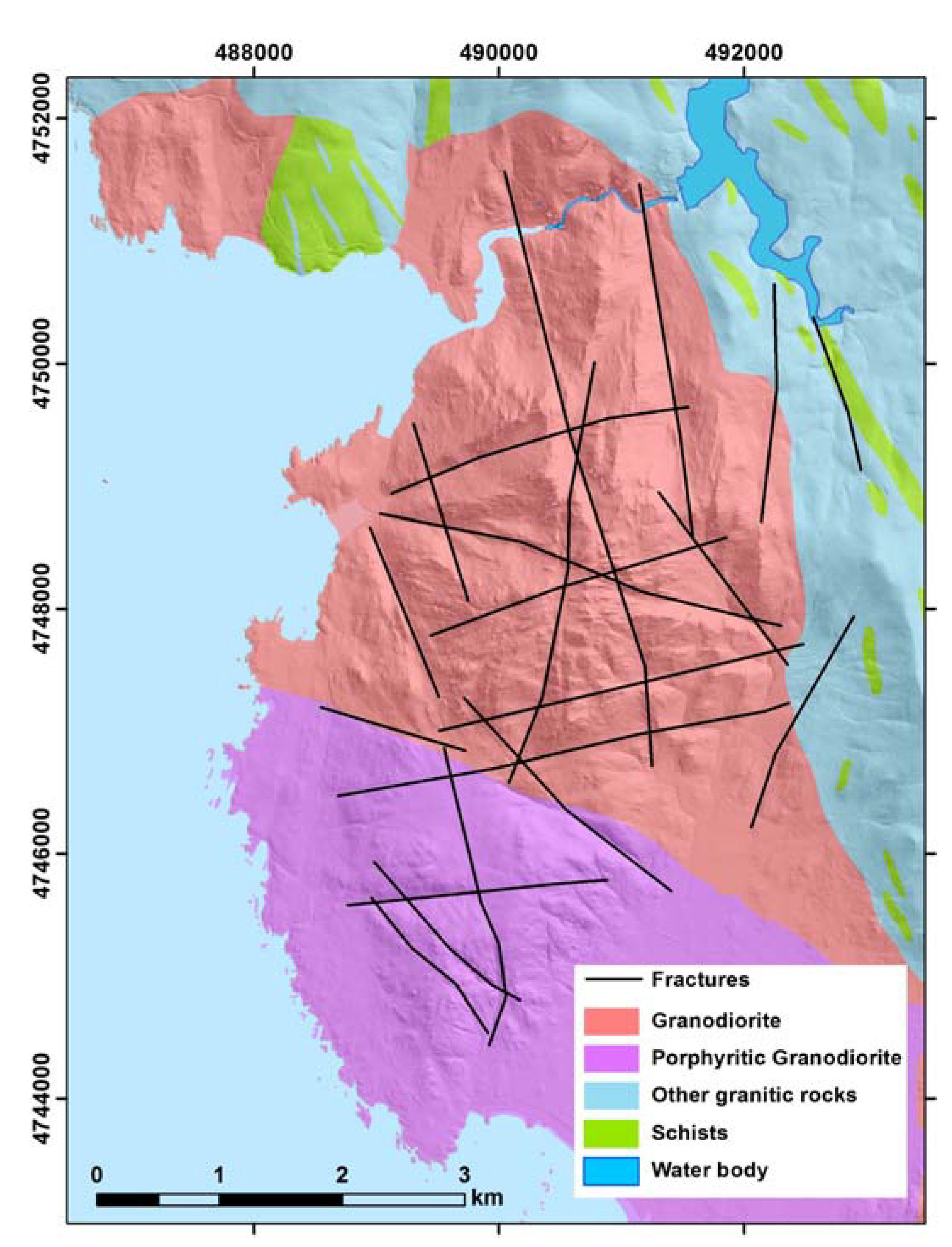
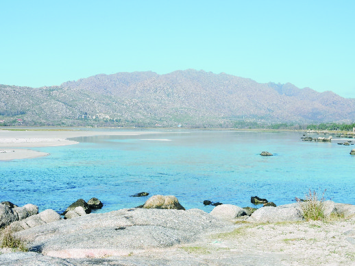
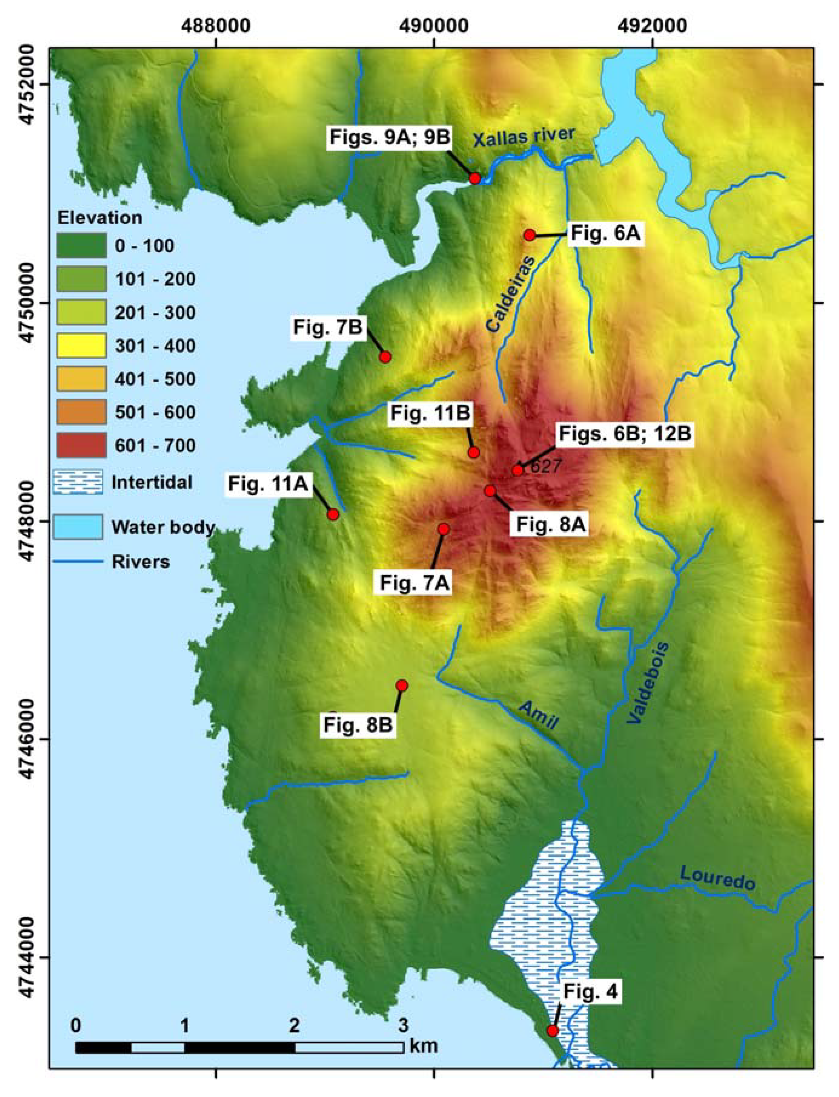
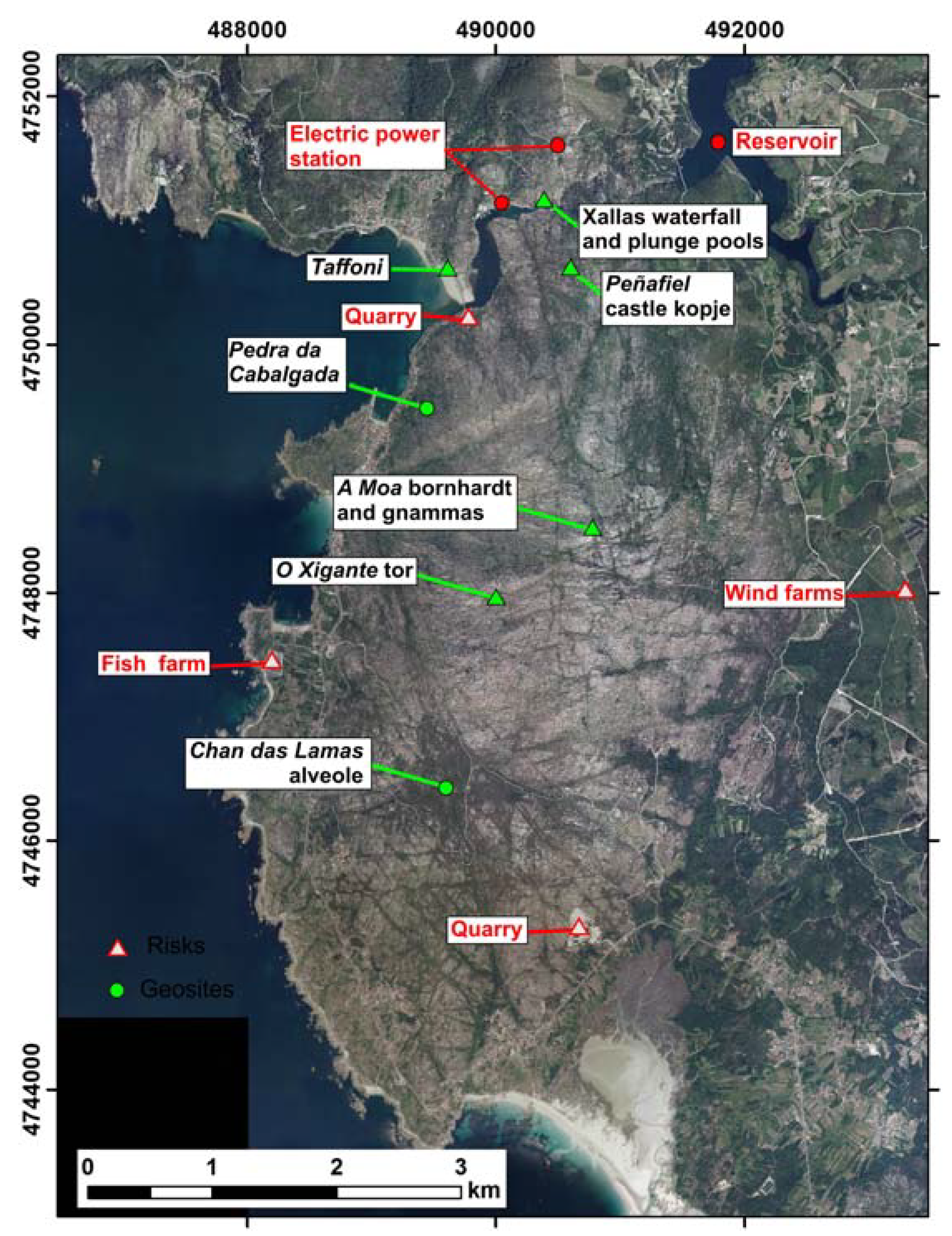
2.1. Regional Setting and Analysis of Geological Context of Monte Pindo

The landscape is characterized by its coastal geodiversity with a large number of potential geosites. Monte Pindo, located on the coast, has great potential for explaining geological processes and its geomorphological heritage is represented by the high degree of geodiversity of its granite landforms.
The massif of Monte Pindo is made up of Late Hercynian calc-alkaline granitoids, with a predominance of biotite, within the group of the late granodiorites [31]. It belongs to the migmatitic domain of granitic rocks. The predominant type of rock is late granodiorite, which intruded after the late phases of folding. It is, therefore, not deformed and can be found in localized massifs in more or less circular forms. It is possible to differentiate two types in the massif: late granodiorite, with marginal facies occupying the northern half and late granodiorite, with central facies, occupying the southern part [32] (Figure 2). These differences have an effect on the final forms. They are biotitic granites, pink in color, which have facies with medium to thick grain (sometimes porphyritic) and are without orientation [33]. They are composed of: quartz, plagioclase, potassium feldspar and biotite. They also have apatite, zircon, clinozoisite, zoisite, fluorite and opaques as accessories. The only difference between the central and the marginal granodiorite facies is the presence of muscovite in the former. Intrusions of quartz are frequent, and are usually found in Late Hercynian fractures in a NE-SW or NNW-SSE direction. Mineralogically, these intrusions are made up of quartz, plagioclase, potassium feldspar and biotite.
The granodiorites, were affected by Late Hercynian tectonics, which determined their future evolution. The geomorphological features appear to show that Neogene tectonics caused a period of decompression leading to the creation of an intense set of blocks, reactivating the Late Hercynian NE-SW fractures [34]. This activity produced an extensive network of vertical joints, from which various different weathering processes began, thus determining the granitic modeling. The breakdown of the granite occurred by means of both physical and chemical weathering, which affected its internal structure, in direct relation with its component materials. This can be seen, for example, in the hydrolysis processes affecting orthoclase, an abundant mineral in the area.
Geomorphological [35] and palynological studies [36] have provided more data on the evolution of the hillsides in more recent times (Cenozoic). The prevailing geomorphological processes during the Quaternary left their mark on the hillsides, especially those of cold and periglacial climate origin, by shaping the valleys and by forming accumulation of debris.
Figure 2. Geological map of the area (simplified from [32]).
Sustainability 07 07049 g002

2.2. Fieldwork and Mapping

Topographical maps at a scale of 1:10,000, aerial photos (flight 1981–1983) at a scale of 1:18,000 and color photos (flight 1989) at a scale of 1:5000 were used in order to identify the landforms and carry out the geomorphological characterization of the sector. This phase consisted of four stages: (a) differentiating the relief units; (b) locating granite landforms; (c) describing and cataloguing representative granite landforms; and (d) analyzing the impacts on the area. The most interesting features from a geomorphological point of view were selected for description.

2.3. Methodological Proposal for the Drawing up of an Inventory of Sites of Geological Interest (SGIs)

In order to carry out a methodological proposal, we followed the guidelines set out in the Methodological Document for the Drawing Up of the Spanish Inventory of Sites of Geological Interest of the Spanish Geological Survey (IGME) [11,37]. For the purposes of this study, Monte Pindo as a whole has been selected as representative of a granite massif to apply this methodology. However, we are aware that it is not a geosite but rather an area that contains many geosites. The assessment of the site of interest under each of the three categories (scientific, educational and touristic) was carried out by applying fixed parameters for each type of value and corresponding coefficients giving each parameter a numerical value 0, 1, 2 or 4 in terms of: representative value; character as a typical site; availability of scientific studies for the site; state of preservation; observation conditions; rarity; geological diversity; educational content/educational use; logistical infrastructure; population density (potential immediate demand); accessibility; intrinsic fragility; association with other elements of natural and/or cultural heritage; scenic value or beauty; informative content/informative use; potential for touristic activities; proximity to recreational areas (potential immediate demand) and socio-economic issues [11,37] (Table 1).
Table 1. Parameters and indicators to calculate sites of geological interest (SGI) value.
MONTE PINDO
ParametersIntrinsic Value
PointsRepresentative
0Not very useful as a model for representation, even in part, of a feature or process
1Useful as a model for partial representation of a feature or process
2Useful as a model for full representation of a feature or process
4The best known example, as far as the geological domain taken into account is concerned, to fully represent a feature or process4
PointsCharacter as a type locality Intrinsic value
0Does not fulfill the following three criteria
1A site of regional reference1
2An internationally recognized site of reference (due to metallogenic, petrological, mineralogical, tectonic, stratigraphical, etc. reasons), or a site of reference for fossils or biozones of wide scientific use
4A stratotype accepted by the IUGS or an IMA type locality
PointsDegree of scientific knowledge of the site Intrinsic value
0Published studies and/or doctoral theses do not exist concerning the site
1Published studies and/or doctoral theses exist concerning the site
2The site has been researched by several scientific groups and has been the object of doctoral theses and published studies referenced in national scientific journals
4The site has been researched by several scientific groups and has been the object of doctoral theses and published studies referenced in international scientific journals4
PointsState of conservation Intrinsic value
0Greatly degraded: the site is practically destroyed
0Degraded: the site is significantly deteriorated
1Altered: There is deterioration which prevents some interesting characteristics from being appreciated
2Favorable with alterations: There is some deterioration which does not significantly affect the value or degree of interest of the Geosite2
4Favorable: The Geosite in question is in a good state of preservation, it is practically intact
PointsConditions of observation Intrinsic value
0With elements strongly masking the features of interest
1With elements which mask the Geosite and which prevent some interesting characteristics from being appreciated
2With some elements which do not prevent the Geosite from being observed in its entirety
4Able to be easily and perfectly observed practically in its entirety4
PointsRarity Intrinsic value
0There are several similar sites in the region
1One of the few known examples on a regional level
2The only known example on a regional level
4The only known example on a national (or international) level4
PointsDiversity Intrinsic value
0The SGI only possesses one main point of interest
1The Geosite possesses another point of interest, in addition to its principal feature, which is not relevant
2The Geosite possesses 2 points of interest, in addition to its principal feature, or only one which is relevant
4The Geosite possesses 3 or more points of interest, or only two more but both are relevant4
PointsEducational content Intrinsic value and use
0Does not fulfill the following three criteria
1It illustrates contents of the university curriculum
2It illustrates contents of the curriculum of any level of the educational system or is being used for university activities
4It is frequently used in educational activities of any level of the educational system4
PointsLogistical Infrastructure Use value
0Does not fulfill the following three criteria
1Accommodation and restaurants for groups of up to 20 people less than 25 km away
2Accommodation and restaurants for groups of up to 40 people less than 25 km away2
4Accommodation and restaurants for groups of 40 people less than 5 km away
PointsPopulation density (potential for immediate demand) Use value and protection
1Less than 200,000 inhabitants within a radius of 50 km1
2Between 200,000 and 1,000,000 inhabitants within a radius of 50 km
4More than 1,000,000 inhabitants within a radius of 50 km
PointsAccessibility Use value and protection
0Does not fulfill the following three criteria (asphalted road without parking facilities, track or path, boat, etc.)
1Direct access via unpaved track suitable for use by vehicles
2Direct access via asphalted road with coach park
4Direct access via unpaved track suitable for use by bus4
PointsSize of SGI
0Features of meters in length which are vulnerable to visits, such as speleothems, etc.0
1Features measuring decameters in length which are not vulnerable to visits but which are sensitive to other, more aggressive, human activities
2Features measuring hectometers in length which could undergo a certain degree of deterioration due to human activity
4Features measuring kilometers in length which are unlikely to suffer deterioration due to human activity)
PointsAssociation with other elements of natural and/or cultural heritage Use value
0There are no elements of natural or cultural heritage within a radius of 5 km
1The presence of a single element of natural or cultural heritage within a radius of 5 km
2The presence of several elements of natural or cultural heritage within a radius of 5 km
4The presence of several elements of both natural and cultural heritage within a radius of 5 km4
PointsSpectacular nature or beauty Intrinsic value
0Does not fulfill the following three criteria
1(1) Amplitude of the relief or (2) flowing rivers/large sheets of water (or ice) or (3) remarkable chromatic variety. Also fossils and/or spectacular minerals
2Coincidence of two of the first three characteristics. Also fossils and/or spectacular minerals
4Coincidence of the first three characteristics4
PointsEducational content/Educational use detected Intrinsic value and use
0Does not fulfill the following three criteria
1It instructs groups of a certain cultural level clearly and expressively
2It instructs groups of any cultural level clearly and expressively on the importance and usefulness of Geology
4It is frequently used in informative content4
PointsPotential for tourism and recreational activities Intrinsic value and use
0No touristic opportunities or recreational activities
1Potential for tourism or the possibility of recreational activities
2Potential for tourism and possibilities for recreational activities2
4There are organized activities
PointsProximity to recreational areas (potential immediate demand) Intrinsic value and protection
0Site located more than 5 km from a recreational area (camp sites, beaches, etc.)
1Site located less than 5 km and more than 2 km from a recreational area (camp sites, well-used beaches, national or natural parks, visitors centers, etc.)
2Site located less than 2 km away and more than 500 m from a recreational area
4Site located less than 500 m away from a recreational area4
PointsSocio-economic environment Use value
0Region located in an area with rates of per capita income, education and employment which are superior to the regional average
1Site located in an area with rates of per capita income, education and employment which are similar to the regional average but less than the national average1
2Site located in an area with rates of per capita income, education and employment which are lower than the regional average
4Site located in an area in socio-economic decline
TOTAL Points53
The most recent methodological document published regarding the Spanish Inventory of Sites of Geological Interest [11] takes into account [38] criteria according to which three types of value should be considered when a site is assessed: its intrinsic value, its value related to potential use, and its value related to the necessity for protection.
Following the collection of data and fieldwork, the next step was to evaluate Monte Pindo according to the above-listed parameters, which were given varying weight in order to evaluate their scientific, educational and touristic interest. Sites with values higher than 6.65 points are considered to be of very high value; between 3.33 and 6.65 of high value; and with less than 3.33 points, of medium value. The inclusion in the Spanish Inventory of Sites of Geological Interest of those geosites whose scientific, educational and touristic value is less than 1.25 points should be reconsidered.
The necessity of protection or its degree of priority is a parameter to be evaluated once a site has been selected due to its intrinsic value and potential for use. A Site of Geological Interest should, firstly, be evaluated according to its intrinsic values in relation to its potential for use in order to determine the three criteria for a SGI; its scientific, educational and touristic-recreational interest or value. Bearing in mind these parameters linked to the site’s necessity of protection, the susceptibility of the SGI to deterioration should be assessed, in order to be able to prioritize its possible protection.
Once the geosite is selected and its values calculated, the susceptibility to natural degradation and vulnerability to anthropic threats must also be calculated. Once the scientific, educational and touristic values have been calculated separately, the degree to which its protection is a priority should be analyzed. To carry this out, a series of parameters focused on establishing the susceptibility of degradation of the SGI is applied, in order to produce an objective score. The susceptibility of degradation is the ease with which a site of geological interest can become degraded according to its size, its fragility and its vulnerability (due to natural or anthropic causes) (Table 2). In order to calculate the susceptibility of degradation due to natural causes (SDN), the size factor (EF) is multiplied by the natural vulnerability (VN). This comes from the product of its fragility (F) due to natural threats (AN). The formula is expressed as follows: SDN = EF × VN = EF × F × AN. A value of between 0 and 10 is attributed. In order to calculate the susceptibility of degradation due to anthropic threats (SDA), the values of the parameters referring to the evaluation of vulnerability due to anthropic threats are added up and multiplied by the size factor of the SGI (EF) and a value of between 0 and 10 is obtained. The formula is as follows: SDA = V × EF. The assessment of the susceptibility of degradation (SD) is carried out by making an average of the susceptibility of natural degradation (SDN) and that of anthropic degradation (SDA). The formula is expressed as follows: SD = ½ (SDN + SDA). As a general rule, the susceptibility of natural or anthropic degradation is considered to be high if the score is higher than 6.66 points and low if it does not exceed 3.33 points. The evaluation of the susceptibility to natural degradation was carried out according to the following specific parameters; size factor of SGI, fragility and natural threats. These values can be seen in (Table 2). The evaluation of the susceptibility to anthropic degradation was carried out according to the following parameters, each one being given a value of 0, 1, 2 or 4: interest to mining or hydro-electric industries, vulnerability to pillaging, proximity to infrastructures, protection regime of site, indirect protection, accessibility (potential aggression), land ownership and access regime, population density (potential aggression), proximity to recreational areas (potential aggression) [11,37].
Once the value (V) and susceptibility of degradation (SD) of Monte Pindo is assessed, it will be possible to determine the extent of the risk of natural (RDN) or anthropic (RDA) degradation and to estimate the protection priority. This factor is an estimate, which combines the susceptibility of degradation of the site with its value. The risk of degradation is indicative of the necessity or priority of protection of this site, as it is possibly the best indicator when it comes to prioritizing acts of preservation. The risk of degradation of the site’s scientific (RDC), educational (RDD) and touristic (RDT) values can be known but the risk of degradation of the SGI (RD) should be considered to be the greatest of the three and not their average. Geosites with an RDA higher than 6.66 are considered to be in need of urgent protection (at high risk of degradation). Those with RDA values of between 3.33 and 6.66 are recommended for protection in the medium-short-term (risk of medium degradation), while those with RDA values lower than 3.33 could be subjected to protection measures in the long-term (risk of low degradation) or do not need protection (insignificant risk of degradation) [11,37].
Table 2. Parameters or indicators for the assessment of the susceptibility to degradation of geosites.
SUSCEPTIBILITY TO NATURAL DEGRADATION (SDN)
ValueSize factor of SGI (EF)Monte Pindo
10/400Features measuring meters in length (vulnerable simply by visits, such as to speleothems, poorly consolidated geological structure, etc.)10/400
6/400Features measuring decameters (poorly consolidated geological structure, such as stratigraphic sections, etc.)
3/400Features measuring hectometers in length which could undergo a certain degree of deterioration due to human activity)
1/400Features measuring kilometers in length which are unlikely to suffer deterioration due to human activity)
ValueFragility (F)
1Very resistant lithologies (quartzites or similar), with little fracturing, without weathering
5Resistant or very resistant but a high degree of fracturing and/or weathering5
10Consolidated soft lithologies with little fracturing and/or weathering
20Unconsolidated lithologies or consolidated but soft and very fractured and/or weathered
ValueNatural Threats (AN)
1SGI not significantly affected by natural processes (geological or biological)
5 SGI affected by natural processes (geological or biological)) of little relevance
10SGI affected by natural processes (geological or biological) of moderate relevance10
20SGI affected by natural processes (geological or biological) of high intensity
SUSCEPTIBILITY TO ANTHROPIC DEGRADATION (SDA)
PointsInterest to mining or hydro-electric industryMonte Pindo
0Substance without interest or a low degree of interest and no alternative explanations in the area
1Substance low or moderate interest and with alternative exploitations in the area
2Substance of great interest and with alternative exploitations in the area2
4Substance of great interest and no alternative exploitations in the area
PointsVulnerability to pillaging
0There is no paleontological or mineralogical deposit or they are difficult to pillage
1Paleontological or mineralogical deposit of low value and easy to pillage1
2Paleontological or mineralogical deposit of great value, with numerous specimens and easy to pillage
4Paleontological or mineralogical deposit, with few specimens and easy to pillage
PointsProximity to infrastructures
0Site unthreatened
1Site located less than 100 m from a main road, 1 km from an industrial or mining activity, less than 2 km from urban land in cities with fewer than 100,000 inhabitants or less than 5 km in greater populations
2Site located adjacent to an industrial or mining activity, with urban land not designated for building or located less than 25 m from a main road2
4Site located in an industrial area, mining exploitation, on urban land or on the edge of a main street
PointsProtection regime of site
1Site located in national parks or nature reserves or other area with a management plan and protected by guards
2Site classified as protected but not subject to management plan and with no guard protection. Also with assets of cultural interest due to its paleontological/archaeological content2
4Site located on rural land and protected from transformation by building thanks to a territorial or urban management, or lacking any kind of protection status
PointsIndirect protection
0Easily accessible
1Site easily accessible but located far from paths and camouflaged by vegetation
2Site easily accessible, only camouflaged by vegetation
4Site lacking any form of indirect protection4
PointsAccessibility (potential aggression)
0No direct access by track. Does not fulfill the following three criteria (asphalted road without parking facilities, track or path, touristic train, boat, etc.)
1Direct access via unpaved track suitable for use by vehicles
2Direct access via asphalted road with coach park
4Direct access via unpaved track suitable for use by bus4
PointsLand ownership and access regime
1Site located in restricted areas and on public property
2Site located in restricted areas and on private property
4Site located in areas of open access (public or private property)4
PointsPopulation density (potential aggression)
0Less than 200,000 inhabitants within a radius of 50 km0
1More than 100,000 but less than 200,000 inhabitants within a radius of 50 km
2Between 200,000 and 100,000 inhabitants within a radius of 50 km
4More than 1,000,000 inhabitants within a radius of 50 km
PointsProximity to recreational areas (potential aggression)
0Sited located more than 5 km from a recreational area (camp sites, beaches, etc.)
1Site located less than 5 km and more than 2km from a recreational area
2Site located less than 2 km and more than 500 m from a recreational area
4Site located less than 500 m away from a recreational area4

3. Results and Discussion

3.1. Patrimonial Types. The Heritage Values of Monte Pindo

Monte Pindo demonstrates a wide variety of added values. These may be intrinsic (representativity, a site of reference, of a scenic nature), intrinsic and relating to use (educational content), use (association with other elements of the natural, historical or ethnological (traditions) heritage, use and protection (fragility, accessibility, etc.), all of which contributes towards a site of exceptional natural and cultural value, as can be seen in the following sections.

3.1.1. Geomorphological Value

Monte Pindo, located on the coast, stands out from the surrounding area thanks to its characteristic and unusual pink color, its 627 m above sea level, and to its wild and irregular appearance (Figure 3 and Figure 4). This is the result of the interaction between internal and external geological processes, which have left a variety of granite forms of incalculable natural value and great beauty. The hill’s relief has great ecological importance as it provides shelter for communities of animals and plant species and even microorganisms, for example on the speleothems [25]. Monte Pindo has great potential for explaining geological processes and its geomorphological heritage is characterized by a high degree of diversity of its granite landforms, constituting a landscape resource that should be preserved and protected.
Figure 3. Topography of the Monte Pindo and surroundings (Elevation data from LiDAR-PNOA © Instituto Geográfico Nacional de España and location of the pictures mentioned in the text.
Sustainability 07 07049 g003
Figure 4. View of Monte Pindo from Carnota beach.
Sustainability 07 07049 g004

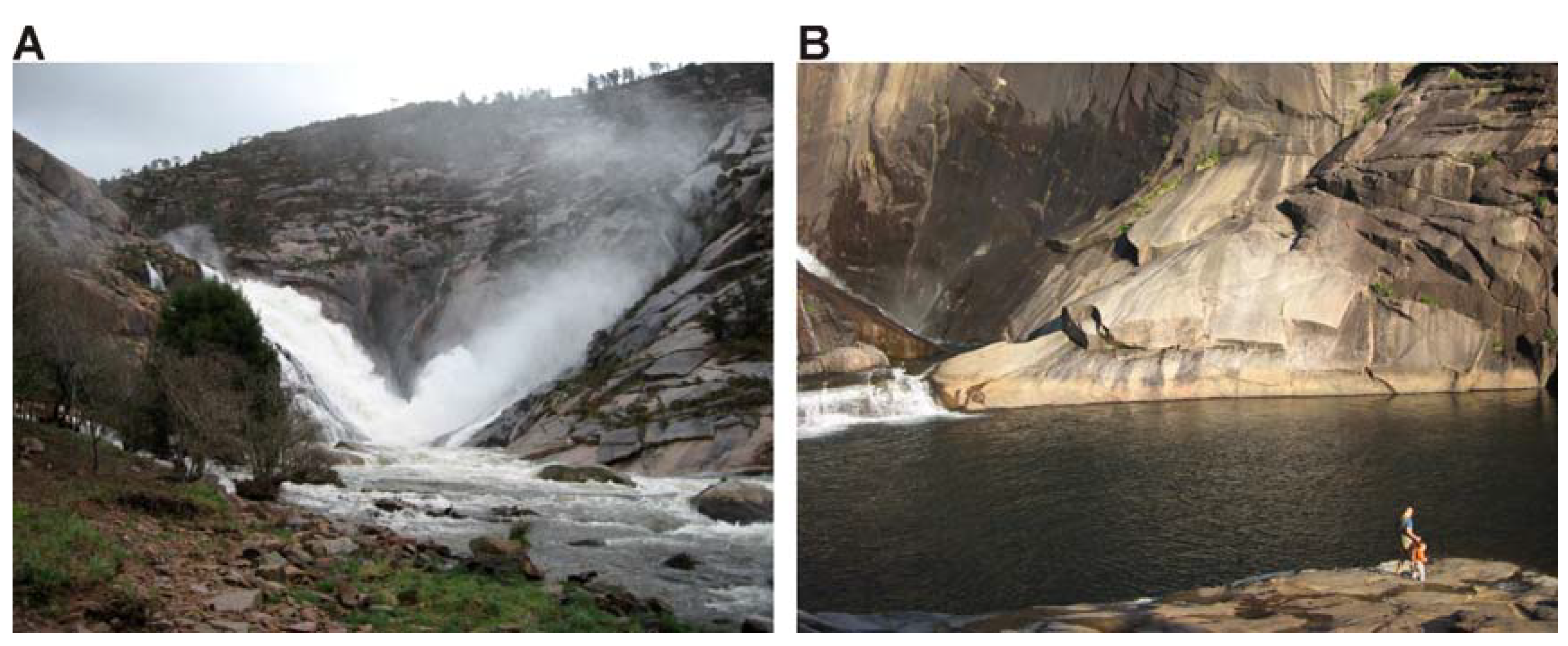
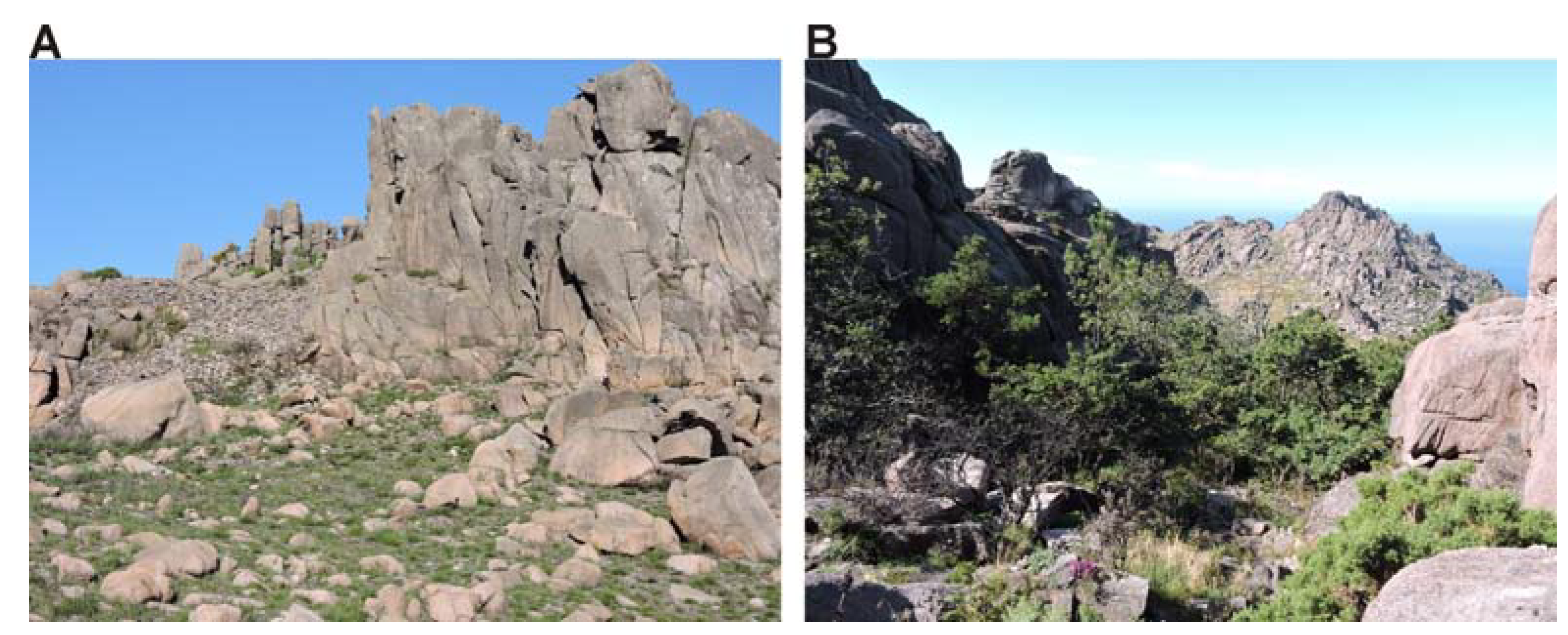
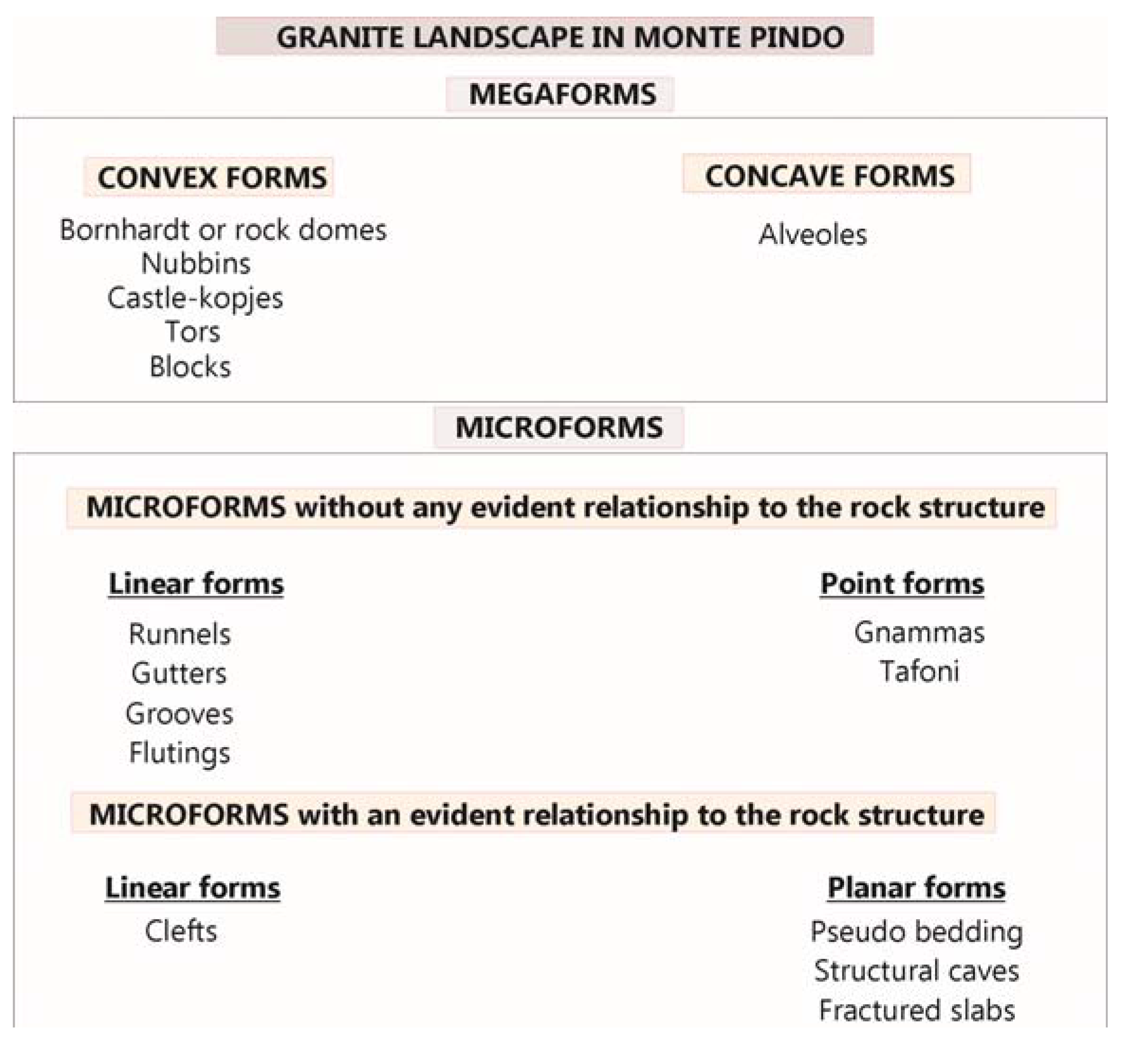
3.1.1.1. Granite Landforms

Studies carried out on the granite geomorphology [39,40,41,42,43,44,45,46] and other specific research on granite forms of Monte Pindo [23,25] have identified and inventoried the most significant aspects. The granite landforms are classified into two groups depending on their size: megaforms or large-scale forms, and microforms or smaller forms [47,48,49] (Figure 5).
Figure 5. The granite landscapes in Monte Pindo classified into two groups depending on their size: megaforms and microforms.
Sustainability 07 07049 g005
Megaforms are those with a minimum size of about 100 meters and can even be up to 1 km in length. Thus, we are dealing with features that allow for a macro- and megascopic description of the landscape of Monte Pindo. Some macroforms (tors, blocks) may have decametric size but they are included in this group because they constitute the traces of the final phase in the evolution of the megaforms. There are convex megaforms (bornhardts or rock domes, nubbins, castle-kopjes, tors, blocks) and concave megaforms (alveoles). The most important are convex megaforms, represented by bornhardts or rock domes, nubbins or incipient rock domes and castle-kopje (Figure 6A). Bornhardts present typical curved surfaces of bare rock, as result of sheet fractures. These landforms dominate the upper sections of the granite massif. In Galicia this type of megaform is named “Moa” due to its rounded and protruding profile. The most representative example corresponds to the hill’s highest point (A Moa, 627 m) (Figure 3 and Figure 6B). Its surface has been carved by numerous gnammas. The castle-kopje is defined by systems or orthogonal joints, which give rise to castle shaped reliefs. They are numerous in the whole sector and are associated with tors. These are convex forms with vertical development. They have horizontal joints, creating parallelepiped blocks, on top of each other, resulting in chaotic forms. They can either appear isolated or in groups or associated with other exhumed megaforms. The term of “tor” is ambiguous [45]. It is of local Cornish origin, meaning a heap or pile. Tor was long used to describe castellated granite outcrops and there are “solid rock outcrops as big as a house rising abruptly from the smooth and gentle slopes of a rounded summit or broadly convex ridge” [39]. A Spanish terminology of granite residuals is worth presenting, as it encompasses more categories than the English language appears to allow. It emphasizes size and fracture control as mutually dependent parameters [44]. But not all geomorphologists seem to agree with the above descriptive meaning of a tor. For example, [40] stated that tors can be described simply as groups of spheroidally weathered boulders, rooted in bedrock and, more significantly, that a castle kopje (angular outcrop) is a distinct landform which also has a different origin. Some tors are extremely representative in Monte Pindo. They can be clearly identified by visitors because they have anthropomorphic, zoomorphic or other resemblances and they have particular names (e.g., “O Xigante-The giant”) (Figure 7A,B).
Figure 6. (A) Examples of bornhardts, nubbins, castle-kopjes at the upper part of the hill; (B) the most representative of bornhardt corresponds to the hill’s highest point (A Moa, 627 m).
Sustainability 07 07049 g006
Figure 7. (A) Tors are frequent and can be easily identified by visitors due to their peculiar morphology, some of them are given popular names due to their anthropomorphic forms, such as the “Giant” (O Xigante); (B) others have zoomorphic forms.
Sustainability 07 07049 g007
There are crests in the massif, residual forms that dominate the elevated parts. In general, the slopes are covered with abundant blocks (Figure 8A). These are the smallest examples of macroforms. They are a consequence of the stripping processes of the granite rock. The origin of these accumulations is not clear but can be attributed to different processes: (i) they respond to gravitational phenomena, which favor the movement of blocks down the slope; (ii) they were generated by surface processes operating in cold climates during the Late Pleistocene, thus making them inherited forms. These accumulations can be compared to others existing in coastal chains, such as the Sierra de A Groba in the south of Galicia [50,51].
Figure 8. (A) The slopes are covered with abundant blocks. (B) Alveole located in Chan das Lamas with a surface area of 200 m.
Sustainability 07 07049 g008
Alveoles are also present in this sector, albeit to a lesser degree. Due to their morphology, they have the capacity to retain and accumulate matter, thus favoring the formation of soil. Their profile is gentle, in many cases almost flat, soil can develop more easily and small wetlands can form, which become spaces with a high degree of paleoenvironmental value and biodiversity for the area. Chan das Lamas and Chan da Moa are good examples (Figure 8B).
Microforms are defined as having a maximum size of one meter, although they are frequently smaller. They are associated with macroforms. Two groups can be distinguished: (a) forms without any evident relationship to the rock structure; and (b) forms with an evident relationship to the rock structure (Figure 5). The first group is represented by linear forms and point forms. The linear forms are: runnels, gutters (developed on a horizontal or very slightly sloped topography), or grooves and flutings (corresponding to similar features developed on inclined surfaces). It is very common to find examples in which these microforms concentrate the water flowing over the rocky surfaces. They are related to small blocks, and are linked to the draining of the gnammas. The point forms are concave: gnammas, tafone, and vasques. These are extremely common on Monte Pindo [25]. Gnammas are small circular depressions. They develop both on flat and sloped surfaces and can be completely enclosed or have a drainage channel. Sometimes the concavities appear on the inner part of a wall. In this case the resulting landform is known as a tafone. On the coast there are beautiful honeycomb structures. These alveoles, usually they occur in groups, not uncommonly along lines of weakness within the rock, and are separated by narrow walls, forming an intricate pattern. Tafoni, by contrast, are singular features and even if two or more tafoni occur side by side, they are usually geometrically different [45].
Concavities can also appear in connection with watercourses. These can reach several meters in size, as is the case of the vasques, or plunge pools of larger dimensions, which are best shown at the base of the Xallas Waterfall, at the mouth of river (Figure 9A,B). The second group, microforms with an evident relationship to the rock structure, can be divided into: linear and planar forms. In the first, clefts can be included and in the second, pseudo bedding, structural caves and fractured slabs. The presence of granitic slabs in the sector must be highlighted, with those located near the mouth of Xallas River being extremely fine examples. They are minor forms that are related to the structure of the rock—their joints are mainly flat in shape and are tilted slightly down. They are associated with other smaller linear forms not related to the rock structure and are usually located on vertical surfaces, such as grooves and channels, with small pits like gnammas.
Figure 9. (A) The Xallas Waterfall is unique on the Atlantic coast of the Iberian Peninsula due to the fact that it falls directly into the sea. (B) Plunge pools at the base of the Xallas Waterfall and the granitic slabs.
Sustainability 07 07049 g009
The study of these granite forms provides valuable data with regard to the formation and evolution of granite massifs and their geomorphological aspects. Granite rocks in general, and cavities in particular [52] are the necessary substratum for lichens, moss and grasses, which constitute the permanent or circumstantial refuges for reptiles. They also accumulate rainwater for aquatic invertebrates, larvae and even occasionally for bats or birds (gnammas or different types). Potential geosites exist in this area, such as the Xallas Waterfall, the variety of tafone found on the hillside of the Xallas hydro-electric power station [25], the A Moa Bornhardt, the castle-kopje (e.g., Pedrullo, Peñafiel) and the tors (e.g., Xigante) and other granite forms which cover the hill (e.g., Pedra da Cabalgada) (Figure 10).
Figure 10. Orthophoto with the location of geosites of particular interest and potentially threatening activities.
Sustainability 07 07049 g010
The geomorphic evolution of granite terrains is controlled by a multitude of factors and they all need to be simultaneously considered if these landscapes are to be properly explained in their wider environmental, geographical, and geotectonic context. It is clear that there is a whole range of granite landforms, at all possible spatial scales, which originate due to certain structural and lithological predispositions. It is most evident in the progress of deep weathering and descent of weathering front and there is usually good correlation between rock characteristics and properties of weathering mantles, unless the duration of profile deepening has been long enough to erase bedrock variability in its upper part. The influence of climatic conditions on the formation of certain granite landforms cannot be denied. But the most evident climatic control is on the rates and intensity of deep weathering. The unique appearance of many granite landscapes and the specific development of individual landforms at individual sites usually results from a unique combination of these controlling factors rather than from a single unique cause [45].
The genesis and evolution of granite landforms would be controlled by: (i) Geological control assumes major importance in granite landscapes. Geotectonic setting and specific rock characteristics helps to explain the distinctiveness of granite morphology and geomorphic variability within the granite areas. Geological control is hierarchical and scale dependent. (ii) The temporal context of relief development is important. Many granite landforms, even more so their regional assemblages, are relatively slow to evolve because of the strength and resistance of the rock. (iii) Granite surfaces, once exposed, are very durable. Burial and exhumation may bring landforms of widely different ages and origins into close juxtaposition. Thus, granite landscapes are expected to have a significant inherited component and if this is not properly recognized, spurious conclusions can be made about some alleged climate–landform relationships. In terms of formative processes, granite landforms are good examples of equifinality [45].

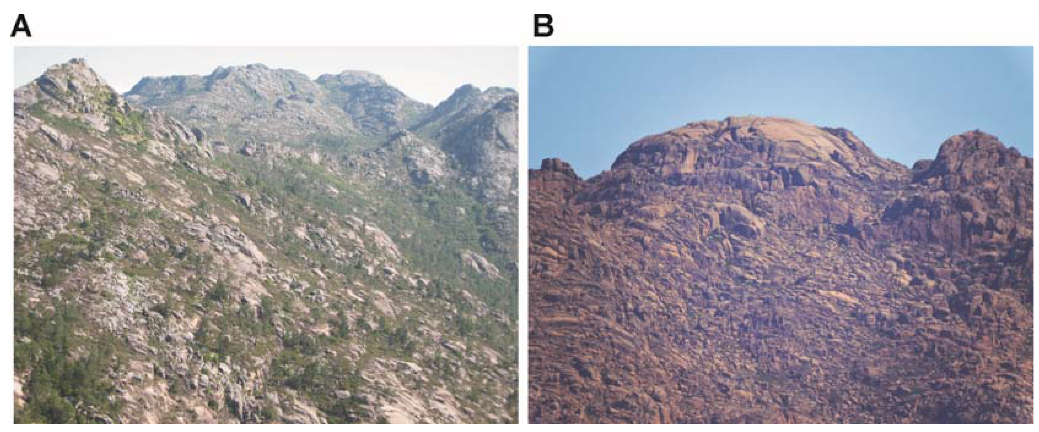
3.1.1.2. The Distribution of the Forms and Their Ages

Arenization has not been observed in any of the geosites. Perhaps some vestiges could be preserved under the soils in the valley bottoms or in alveolar depressions. We are aware of the possibility of searching for new outcrops exposed by work carried out to open/widen roads, and, if arenization is visible, then these sites could be included to complement the explanation of the processes. Broadly speaking, the distribution of the granite forms can be divided into two sectors [25]: (i) The periphery of mica granite (biotite). This has the greatest topographic highlights and is also the youngest part (Figure 2 and Figure 3). It has a pinkish hue, which can be attributed to the oxidation of the iron contained in the granite minerals by the oxygen in the atmosphere. It has large fractures in a N-S and NE-SW direction and its northern part is divided by the Xallas River. Bornhardts, tors, fractured slabs, tafoni and gnammas are present in large numbers. The cosmogenic measurements carried out and applied to exposed granite surfaces give ages of 49 ± 24 Ka B.P. [23]; (ii) The central area, formed of granite with two types of porphyritic mica (biotite and muscovite), which do not form cavities so well. This is the oldest and most degraded area, which presents more monotonous landscapes where arenization develops, gnammas or runnelsrills, rock domes, that occur very eroded, and there is an abundance of blocks. This area has large NW-SE, N-S and NE-SW fractures (Figure 2 and Figure 3). It has a surface area of 200 m (Chan das Lamas), which is strongly defined by the sheet structure. The cosmogenic measurements carried out and applied to exposed surfaces give ages of 88 ± 27 Ka B.P. [22].

3.1.2. Geocultural Value

Monte Pindo is, above all, a spectacular landscape, which can be appreciated on numerous levels. It is a landmark from the sea and from inland due to the fact that the hill, with its pinkish hue, stands out on the horizon, due to its macroforms and also, from closer up, its granitic microforms. It dominates a landscape of great beauty, rising to the Alto da Moa at 627 m above sea level. It is a spectacular viewpoint over the coastline extending from Cape Fisterra to beyond the Muros-Noia Ria. In Latin, Fisterra means “the end of the Earth”. Cape Fisterra is located in the northwest of Spain in Galicia. It is considered to be the western-most point of continental Europe, although geographers have demonstrated that the capes of Roca in Portugal and Touriñán—very close to Fisterra, also in Galicia—are situated further to the west. Other European mythical “ends of the world” include Land’s End in Britain, Finistère in Brittany, France and Dingle in Ireland. The end of the world is linked to the idea of conquering territories and expanding the limits of the known world [53,54].
From ancient times, many historians, geographers and writers have made reference to the greatness and the mystery surrounding Monte Pindo, one of the most mythical places in Galicia. The first clear documentary reference to its name came from Padre Sarmiento who described the massif in his book “Viaxe a Galicia” and referred to it as “Monte Pindo”, thus affirming that it was named due to its similarity to the Pindos Mountains in Greece [21]. Another famous name also made reference to the site in his “Guía de Galicia”, dating from 1926 [22,55]. He refers to the hill in this way: «Se le ha llamado uno de los Olimpos Célticos de Galicia y es, en verdad, uno de los más bellos montes litorales de ella» (“It has been called one of the Celtic Olympus of Galicia and is, truly, one of the most beautiful coastal mountains it possesses”). It is, perhaps, due to this reference that Monte Pindo has come to be known as the Celtic Olympus of Galicia. Thus, the hill came to be a reference point and a symbol of identity in the strengthening of Galician roots and was used by the intellectuals of the time belonging to the Xeración Nós, such as Otero Pedrayo and Vicente Risco.
However, the site is also, according to oral tradition, a place where the sun, the stars and the elements were worshipped. The particular shape of the hill has led to the creation of a multitude of legends and fantastical stories. Furthermore, very real stories, close to the heart of the local population, have been forged, such as those in which the rocks of the hillside served as a refuge for those escaping the enemy during the Spanish Civil War.
On an archaeological level, Monte Pindo is rich in cultural heritage. Archaeological remains can be found dating from different historical periods. Rock art carved out of the pink granite, remains of Neolithic structures, forts (the castle of San Xurxo, built in the 10th century and destroyed by the Irmandiños in 1467, and the castle of Peñafiel), hermitages, walls, paths, etc., all reflect the fact that this place has been occupied and used by different cultures throughout history [56,57,58,59,60] (Figure 11A).
Figure 11. (A) Archaeological remains located in the left side of Castle-kopje; (B) Quercus lusitanica in the small valley, between castle-kopjes.
Sustainability 07 07049 g011
Monte Pindo is a symbol of identity with the landscape for both the local population and visitors from outside the area. This fact leads to the hill being valued in different ways. Some members of the local population have set up an association with the aim of protecting the landscape. This association is supported by other groups, political parties and researchers, who argue that Monte Pindo should be proclaimed a “Natural Park” in order to protect the landscape with the aim of ensuring its preservation for future generations [26]. On the other hand, another part of the local population is against this idea due to the restrictions, which would be put in place regarding constructions, routes, events, etc., although the Monte is also a symbol of identity for them, an idea that is often reinforced by the sense of pride they obtain from visitors’ opinions of the site. Geomorphological heritage becomes a local heritage, captured by local population and visitors. All this contributes to the evaluation and dissemination of geomorphological heritage [20].
The concern for the protection of Monte Pindo is not only a current matter. The first reference to the site’s protection comes from a 1917 Royal Decree dated 23 February, is cited by the geographer [61]. As the result of a study entrusted to the district forestry engineers (Pedro Pidal and Bernaldo de Quirós), Monte Pindo was proposed as one of 46 “notable sites” which were candidates for becoming National Parks or National Sites (the equivalent of modern-day Natural Parks). This was a pioneering environmental policy in the Europe of the time, which, unfortunately, would never become fully-defined or developed.

3.1.3. Biodiversity Value

Monte Pindo is designated as SCI ES (Site of Community Interest) 1110008 Carnota-Monte Pindo, and is included in the Natura 2000 network as an area of special protection of natural values related to both its vegetation and birdlife (ZEPA). The mountain has a protection category at Community level (SCI) due to its wealth of plant species (about 650 species have been catalogued, fifty of them protected and some in “critical” danger of extinction). It has five habitats protected by a European directive, eight plant species and twelve different species of wildlife also have regional protection. Here, the Quercus lusitanica, a shrub existing only in Galicia, central Portugal, the southern provinces of Cadiz and Malaga and in the north of Africa, deserves special mention (Figure 11B). The biotic aspects of Monte Pindo are protected by the public administration, but the abiotic aspects, which are the lifeline of the Monte, are currently completely unprotected. Furthermore, the threat of fire cannot be ignored. Fires occur frequently and the effects are devastating. Fauna and vegetation (mainly oaks, wetland vegetation and threatened species) suffer directly from intentional fires. These are repeated cyclically. The effects are catastrophic for wildlife, vegetation and soil. But there is no preventive policy on the part of the Administration for this not to happen again.

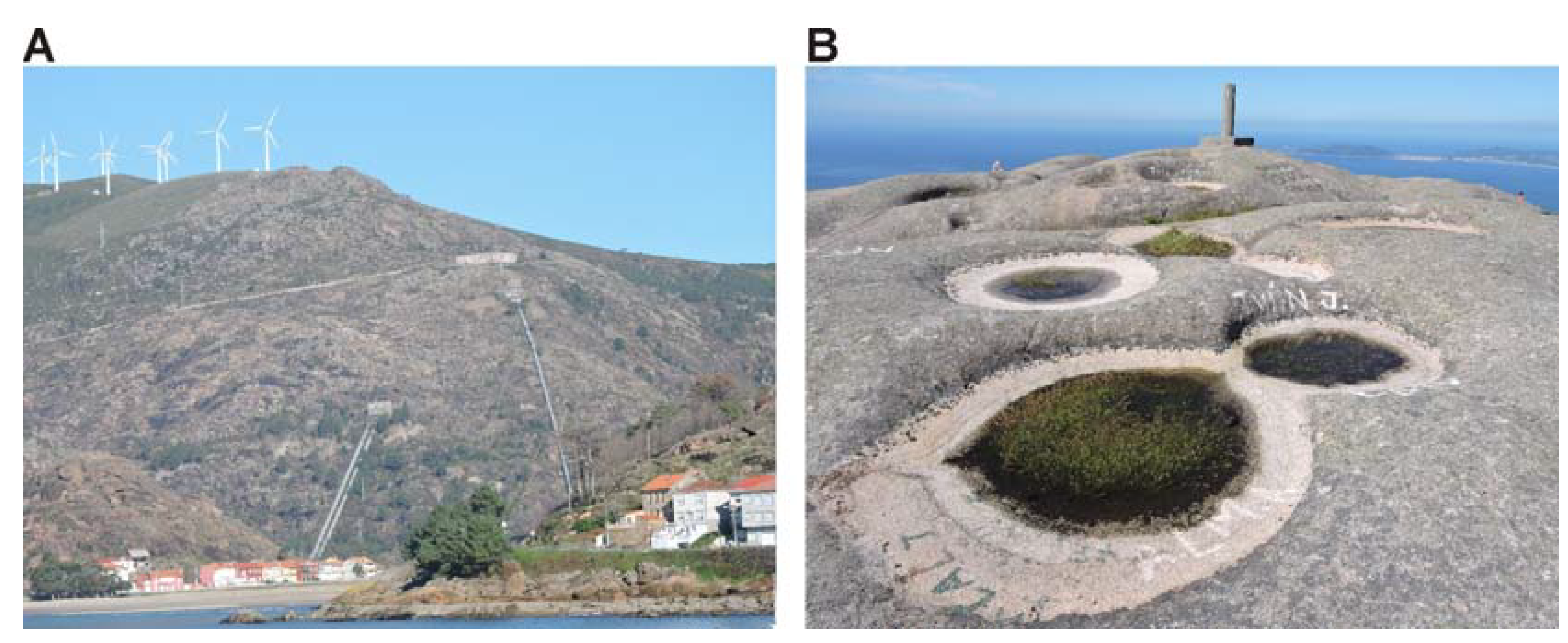
3.1.4. Vulnerability

Monte Pindo is an area with a spectacular granite landscape but it is severely threatened and extremely vulnerable. The Administration is aware of this situation but stands by and refuses to give a solution. The construction of an electric power station, wind farms, a reservoir, quarries and a fish farm have had a great impact on the area, which is not reflected economically in the local population (Figure 10).
The construction of an electric power station located in the council of Ézaro, at the foot of Monte Pindo, has had a great visual impact on the area, both due to the construction of the plant and to the pipelines which scar the hillside (Figure 12A).
Figure 12. (A) The construction of an electric power station, pipeline, wind farms, etc., have had a great impact on the area. (B) Gnammas with vegetation in A Moa (627 m), this surface is marked with graffiti.
Sustainability 07 07049 g012
The reservoir, built by the company Carburos Metálicos, was finished at the end of the 1980s. It was built at the mouth of the river without respecting its environmental flow. This has resulted in alterations to the minimum flow necessary for the preservation of the river’s ecological values (such as the natural habitats of a wealth of flora and fauna), its environmental functions (such as the dilution of contaminants, the absorption of climatological and hydrological extremes) and the preservation of the landscape. Its construction modified the biotope’s natural conditions, without guaranteeing the functioning of natural life as had existed prior to its existence. This river, before it meets the sea, has formed three waterfalls over granitic material and wide pools with sculpted columns. The largest of the waterfalls lies at the river’s mouth and is known as “A Fervenza do Xallas” (Xallas Waterfall), unique on the Atlantic coast of the Iberian Peninsula due to the fact that it falls into the sea. The construction of the reservoir, as well as altering the dynamics of the Xallas River, led to the destruction of the village of Sta. Uxía and its farmland. It also caused alterations of a biological nature. The elver, the fry of the eel, from the anguillidae family, suffered the alteration of its migration due to the reduction in the quantity of water, which is now retained by the dam. From the construction of the reservoir in 1988, the Xallas River did not maintain the minimum environmental flow at its mouth until 2011. The gates were only opened for the waterfall to flow on specific dates and according to a timetable established by the regional government. The current lease-holder, “FerroAtlántica”, has been obliged to maintain the river’s minimum environmental flow in accordance with the law entitled “Resolución de Aguas de Galicia”. This decision was motivated by the complaints made by residents of the area along with an ecological group called “Ríos Sin Vida”, who made their complaints heard in Europe, demanding that the Xallas River have its environmental flow at its mouth. One of the most damaging actions suffered by Monte Pindo is the uncontrolled exploitation of the Xallas [62]. It refers to the depletion of the flow of a living river, firstly made into a dry riverbed, then a Sunday waterfall and finally a prostatic dribble.
Yet another threat to the site is the construction of wind farms, which surround the area. It is still feared that new wind turbines may be installed, leaving Monte Pindo as an island besieged by a sea of windmills. “Eurovento’s project” to construct more wind farms threatens an even more serious gradual destruction of the wealth of heritage of the area. This company’s documentation recognizes that it plans to build three new farms, which would have an impact on both the environment and the landscape of the hill. However, the company alleges, to its own benefit, that these installations would be much smaller than others that already exist in the area [63] (Figure 12A).
Monte Pindo is also under threat from quarries, attracted by its pink granite. The effects of quarrying are irreversible [62] (an open-cast quarry for the construction of the Santa Uxía reservoir, heaps left following the installation of the pipelines for the Ézaro hydro-electric power station and the Caldebarcos quarry). The most direct impact is visual. However, the extraction of granite leads to the destruction of the most important value of the hill, its abiotic aspect, the rock with its granitic model, which sustains great biodiversity. It should be highlighted that the great value of the rock for the construction industry, without prior control on the part of the local administrations, means that this area is extremely vulnerable to this kind of threat.
The construction of a fish farm, the “Stolt Sea Farm”, at the foot of the hill, in the village of Quilmas-Carnota, has also had a significant effect on the coastline. The fish farm, some 123,935 m2 in size, lies within the SCI Carnota-Monte Pindo, an area of high ecological value, which forms part of the Galician Red Natura. What is more, its location affects habitats and species of European interest according to EU Directive 92/43. The immediate surroundings of the farm, which is coastline, is not looked after. The installations have a strong visual impact on the area. Tracks have been opened up over the dunes, waste is not disposed of correctly and the pipes of the fish farm are visible. All of this contributes towards a high level of vulnerability for such a fragile habitat as the coastline. In addition, complaints from nearby residents must be taken into account regarding the dumping of wastewater. Faced with this situation, the directors of the farm have no interest in, or even stand against, Monte Pindo acquiring legal protection. A protection status would oblige them to keep to certain guidelines in the fish farm, which, at the present time, they do not fulfill. The number of jobs created is negligible. Fish farms on land only generate 9% of the total of employment in the area of fish farming, with an average of 31 professionals per company, according to data from the survey on the population employed by the marine fishing and fish farming sectors in Galicia (Ocupesca), recently published by the Consellería de Medio Rural e do Mar [64]. The benefits provided by the farm to the local population do not compensate for the impact caused on the landscape, particularly on coastal heritage, to its geodiversity and biodiversity. The lack of protection from all levels of government (local, regional and national) has led to a seriously damaging use of the coastline. It is, therefore, necessary for Monte Pindo to obtain recognition and protection, so that the farms installed there can be better controlled and fulfill the requisite European regulations.
The hill is periodically burnt by deliberate fires, usually in the summer when the northwest wind blows more strongly. If there is extreme precipitation following the fires, this can lead to catastrophic events on the landscape. The intensity of the rain can have a great impact on the formation and development of colluvial soil [65]. Not all precipitation leads to erosive processes on the hillsides, as it also depends on other associated factors, such as the intensity of the rain, the type of geomorphological unit affected, the existence, or not, of vegetation, etc. Therefore, the effects of the rain are added to those of the fires, thus causing the ground to be more sensitive to the effects of erosion [66]. In this way, a section of land unprotected by vegetation becomes eroded and a significant amount is lost in the sea. There is also evidence that the properties of the soil are affected by a combination of deforestation, fire, erosion and modifications to the vegetation. One of these properties is the reaction of the soil (pH) [67,68]. Thus, the change in the forestry cover is accompanied by the acidification of the soil. The most worrying effect of the fires is the loss of soil. This means that there is a geomorphological reconfiguration of the landscape. The material accumulates in streambeds and basins, with the hillsides becoming more and more deprived of soil and the rock, often blackened by fire, coming to the fore [69].
These fires are started deliberately for no apparent reason. The area is totally unprotected by the government, as there is no kind of maintenance of the hill. No preventive work is carried out. There is no policy for control and this does not appear to be of interest to the Administration. The vegetation destroyed by the fires is mainly pine and eucalyptus, which are invasive species. For this reason, the recovery of the area should avoid the reintroduction of these species. Although Quercus lusitanica suffers damage, its greater resistance to fire means that it can hide in small valleys and rocky areas with little soil. Finally, the high volume of visitors must be mentioned. The number of people who climb Mount Pindo (627 m above sea level) is very high. Tours are conducted without any control or planning, paths are made, the rocks are graffitied, people use motorbikes and quads and mass sporting events are organized (Figure 12B). Therefore, heightened social responsibility towards the use of Earth’s resources is needed, specifically of its geomorphological elements with exceptional scientific, educational, touristic or cultural value.

3.2. Proposal for the Assessment of Degradation Risk and Estimate of Protection Priority for Monte Pindo

Monte Pindo, located on the coast, has great potential for explaining geological processes and its geomorphological heritage is characterized by a high degree of geodiversity of granite landforms. Heritage values are represented by geological, geomorphological, biotic, geocultural and educational features. Monte Pindo should be considered as an area, with a high number of potential geosites, in terms of its scientific value based on geological, geomorphological, coastal geomorphology and other criteria.
The score obtained for the “VC” (Scientific Value) was 8.75, The “VD” (Educational value) score was 7.75 and the score for “VT” (Touristic Value) was 6.87 (Table 3).
Table 3. Calculation of scientific, educational and touristic value.
PointsValue of InterestScientific (VIc)Educational (VId)Touristic or Recreational (VIt)Monte Pindo
VIcVIdVIt
Representative (R)
0Not very useful as a model for representation, even in part, a feature or process×30×5×0
1Useful as a model for partial representation of a feature or process×30×5×0
2Useful as a model for full representation of a feature or process×30×5×0
4The best known example, as far as the geological domain taken into account is concerned, to fully represent a feature or process×30×5×0120200
Character as a type locality (T)
0Does not fulfill the following three criteria×10×5×0
1A site of regional reference×10×5×01050
2An internationally recognized site of reference (due to metallogenic, petrological, mineralogical, tectonic, stratigraphical, etc. reasons), or a site of reference for fossils or biozones of wide scientific use×10×5×0
4A stratotype accepted by the IUGS or an IMA type locality×10×5×0
Degree of scientific knowledge of the site (K)
1Published studies and/or doctoral theses exist concerning the site×15×0×0
2The site has been researched by several scientific groups and has been the object of doctoral theses and published studies referenced in national scientific journals×15×0×0
4The site has been researched by several scientific groups and has been the object of doctoral theses and published studies referenced in international scientific journals×15×0×06000
State of conservation (C)
0Greatly degraded: the site is practically destroyed×10×5×0
0Degraded: the site is significantly deteriorated×10×5×0
1Altered: There is deterioration which prevents some interesting characteristics from being appreciated×10×5×0
2Favorable con alterations: There is some deterioration which does not significantly affect the value or degree of interest of the Geosite×10×5×020100
4Favorable: The Geosite in question is in a good state of preservation, it is practically intact×10×5×0
Conditions of observation (O)
0With elements strongly masking the features of interest×0×5×5
1With elements which mask the Geosite and which prevent some interesting characteristics from being appreciated×10×5×5
2With some elements which do not prevent the Geosite from being observed in its entirety×10×5×5
4Able to be easily and perfectly observed practically in its entirety×10×5×5402020
Rarity (A)
0There are several similar sites in the region×15×5×0
1One of the few known examples on a regional level×15×5×0
2The only known example on a regional level×15×5×0
4The only known example on a national (or international) level×15×5×060200
Diversity (D)
0The SGI only possesses one main point of interest×10×10×0
1The Geosite possesses another type of interest, in addition to its principal feature, which is not relevant×10×10×0
2The Geosite possesses 2 types of interest, in addition to its principal feature, or only one which is relevant×10×10×0
4The Geosite possesses 3 or more types of interest, or only two more but both are relevant×10×10×040400
Educational content (CDD)
0Does not fulfill the following three criteria×0×20×0
1It illustrates contents of the university curriculum×0×20×0
2It illustrates contents of the curriculum of any level of the educational system or is being used for university activities×0×20×0
4It is frequently used in educational activities of any level of the educational system×0×20×00800
Logistical Infrastructure (LL)
0Does not fulfill the following three criteria×0×15×5
1Accommodation and restaurant for groups of up to 20 people less than 25 km away×0×15×5
2Accommodation and restaurant for groups of up to 40 people less than 25 km away×0×15×503010
4Accommodation and restaurant for groups of 40 people less than 5 km away×0×15×5
Population density (potential immediate demand (DP)
1Less than 200,000 inhabitants within a radius of 50 km×0×5×5055
2Between 200,000 and 1,000,000 inhabitants within a radius of 50 km×0×5×5
4More than 100,000 inhabitants within a radius of 50 km×0×5×5
Accessibility (AC)
0Does not fulfill the following three criteria (asphalted road without parking facilities, track or path, boat, etc.)×0×10×10
1Direct access via unasphalted track suitable for use by vehicles×0×10×10
2Direct access via asphalted road with coach park×0×1 0×10
4Direct access via unasphalted track suitable for use by bus×0×10×1004040
Size of SGI (E)
0Features of meters in length which are vulnerable to visits, such as speleothems, etc.×0×5×15000
1Features measuring decameters in length which are not vulnerable due to visits but which are sensitive to other, more aggressive, human activities×0×5×15
2Features measuring hectometers in length which could undergo a certain degree of deterioration due to human activity×0×5×15
4Features measuring kilometers in length which are unlikely to suffer deterioration due to human activity×0×5×15
Association with other elements of natural and/or cultural heritage (NH)
0There are no elements of natural or cultural heritage within a radius of 5 km
1The presence of a single element of natural or cultural heritage within a radius of 5 km×0×5×5
2The presence of several elements of natural or cultural heritage within a radius of 5 km×0×5×5
4The presence of several elements of both natural and cultural heritage within a radius of 5 km×0×5×502020
Spectacular nature or beauty (B)
0Does not fulfill the following three×0×5×20
1(1) Amplitude of the relief or (2) flowing rivers/large sheets of water (or ice) or (3) remarkable chromatic variety. Also fossils and/or spectacular minerals×0×5×20
2Coincidence of two of the first three characteristics. Also fossils and/or spectacular minerals×0×5×20
4Coincidence of the first three characteristics×0×5×2002080
Educational content/Educational use detected (CDV)
0Does not fulfill the following three criteria×0×0×15
1It instructs groups of a certain cultural level clearly and expressively×0×0×15
2It instructs groups of any cultural level clearly and expressively on the importance and usefulness of Geology×0×0×15
4It is frequently used in informative content×0×0×150060
Potential for tourism and recreational activities (PTR)
0No tourist opportunities or recreational activities×0×0×5
1Potential for tourism or the possibility of recreational activities×0×0×5
2Potential for tourism and possibilities for recreational activities×0×0×50010
4There are organized activities×0×0×5
Proximity to recreational areas (potential immediate demand) (ZR)
0Site located more than 5 km from recreational area (camp sites, beaches, etc.)×0×0×5
1Site located less than 5 km away from a recreational area (camp sites, well-used beaches, national or natural parks, visitors centers, etc.)×0×0×5
2Site located less than 2 km away from a recreational area×0×0×5
4Site located less than 500 m away from a recreational area×0×0×50020
Socio-economic environment (ES)
0Region located in a district with rates of per capita income, education and employment which are superior to the regional average×0×0×10
1Site located in a district with rates of per capita income, education and employment which are similar to the regional average but less than the national average×0×0×100010
2Site located in a district with rates of per capita income, education and employment which are less than the regional average×0×0×10
4Site located in a district with socio-economic decline×0×0×10
SUMS∑C∑D∑T350310275
VALUE (over 10)VC = ∑C/40VD = ∑D/40VT = ∑T/408.757.756.87
Sites with values higher than 6.65 points are considered to be of very high value. With regard to the criteria for evaluating the susceptibility of degradation (fragility and vulnerability) of Monte Pindo, the scores obtained for the susceptibility to natural degradation (SDN) were 1.25 and for susceptibility to anthropic degradation (SDA) 5.38. Finally the score obtained for the susceptibility to degradation was 3.32. Susceptibility to anthropic degradation is considered low, because the score is lower than 3.33 points, while susceptibility to anthropic degradation is medium, not exceeding 6.66 points [11,32] (Table 4).
Table 4. Calculation of the susceptibility of degradation (fragility and vulnerability).
ValueSize factor of SGI (EF)Monte Pindo
10/400Features measuring meters in length (vulnerable simply by visits, such as to speleothems, poorly consolidated geological structure, etc.)10/400
6/400Features measuring decameters (poorly consolidated geological structure, such as stratigraphic sections, etc.)
3/400Features measuring hectometers in length which could undergo a certain degree of deterioration due to human activity)
1/400Features measuring kilometers in length which are unlikely to suffer deterioration due to human activity)
ValueFragility (F)Monte Pindo
1Very resistant lithologies (quartzites or similar), with little fracturing, without weathering
5Resistant or very resistant but a high degree of fracturing and/or weathering5
10Consolidated soft lithologies with little fracturing and/or weathering
20Unconsolidated lithologies or consolidated but soft and very fractured and/or weathered
ValueNatural Threats (AN)Monte Pindo
1SGI not significantly affected by natural processes (geological or biological)
5SGI affected by natural processes (geological or biological)) of little relevance
10SGI affected by natural processes (geological or biological) of moderate relevance10
20SGI affected by natural processes (geological or biological) of high intensity
SDN = EF × VN = EF × F × AN = 10/400 × 5 × 10 = 1.25
VULNERABILITY ASSESSMENT TO ANTHROPOGENIC THREATS
MONTE PINDO
PointsWeightValue
Interest to mining or hydro-electric industry (M)
0Substance without interest or a low degree of interest and no alternative explanations in the area×25
1Substance low or moderate interest and with alternative exploitations in the area×25
2Substance of great interest and with alternative exploitations in the area×2550
4Substance of great interest and no alternative exploitations in the area×25
Vulnerability to pillaging (Ex)
0There is no paleontological or mineralogical deposit or they are difficult to pillage×25
1Paleontological or mineralogical deposit of low value and easy to pillage×2525
2Paleontological or mineralogical deposit of great value, with numerous specimens and easy to pillage×25
4Paleontological or mineralogical deposit, with few specimens and easy to pillage×25
Proximity to human activities (infrastructures) (Urb)
0Site unthreatened×15
1Site located less than 100 m from a main road, 1 km from an industrial or mining activity, less than 2 km from urban land in cities with fewer than 100,000 inhabitants or less than 5 km in greater populations×15
2Site located adjacent to an industrial or mining activity, with urban land not designated for building or located less than 25 m from a main road×1530
4Site located in an industrial area, mining exploitation, on urban land or on the edge of a main street×15
Accessibility (potential aggression) (Ac)
0No direct access by track. Does not fulfill the following three criteria (asphalted road without parking facilities, track or path, touristic train, boat, etc.)×10
1Direct access via unpaved track suitable for use by vehicles×10
2Direct access via asphalted road with coach park×10
4Direct access via unpaved track suitable for use by bus×1040
Physical or indirect protection (PF)
0Easily accessible×5
1Site easily accessible but located far from paths and camouflaged by vegetation×5
2Site easily accessible, only camouflaged by vegetation×5
4Site lacking any form of indirect protection×520
Protection regime of site (P)
1Site located in national parks or nature reserves or other area with a management plan and protected by guards×5
2Site classified as protected but not subject to management plan and with no guard protection. Also with assets of cultural interest due to its paleontological/archaeological content×510
4Site located on rural land and protected from transformation by building thanks to a territorial or urban management, or lacking any kind of protection status.×5
Land ownership and access regime (TS)
1Site located in restricted areas and on public property×5
2Site located in restricted areas and on private property×5
4Site located in areas of open access (public or private property)×520
Population density (potential aggression) (DP)
0Less than 200,000 inhabitants within a radius of 50 km×50
1More than 100,000 but less than 200,000 inhabitants within a radius of 50 km×5
2Between 200,000 and 100,000 inhabitants within a radius of 50 km×5
4More than 1,000,000 inhabitants within a radius of 50 km×5
Proximity to recreational areas (potential aggression) (ZR)
0Site located more than 5 km from a recreational area (camp sites, beaches, etc.)×5
1Site located less than 5 km and more than 2 km from a recreational area×5
2Site located less than 2 km and more than 500 m from a recreational area×5
4Site located less than 500 m away from a recreational area×520
TOTAL Points215
SDA = V × EF = 215 × 10/400 = 5.375/= 5.38 SD = ½ (SDN + SDA) = ½ (1.25 + 5.38) = 3.315/= 3.32
Table 5 shows the calculation of the degradation risk and estimate for protection priority. The degradation risk of Monte Pindo due to natural threats (RDN) reaches maximum values of 1.09 (RDNC score), the degradation risk due to anthropic threats (RDA) is 4.71 (RDAC score), and the degradation risk of SGI (RD) is 2.95 (RDC score). The estimate of the protection priority of Monte Pindo was carried out based on the risk of degradation to anthropic threats. The score obtained for necessity/protection priority is 4.71, maximum value of RDA. Geosites with RDA values of between 3.33 and 6.66 are recommended for protection in the medium-short-term (risk of medium degradation). This suggests that a specific protection status is necessary for Monte Pindo in the medium-term (short-term measures of geoconservation) [11,37] (Table 5).
Table 5. Calculation of degradation risk and estimate of protection priority of Monte Pindo.
InterestSymbol
Scientific value of SGIVC = 8.75
Educational value of SGIVD = 7.75
Touristic value of SGIVT = 6.88
Susceptibility to natural degradationSDN = 1.25
Susceptibility to anthropogenic degradationSDA = 5.38
SGI Susceptibility to degradationSD = ½ (SDN + SDA) = 3.32
SymbolFormulaResult: MONTE PINDO
Degradation risk of scientific value due to natural hazardsRDNCRDNC = 1/10·(VC × SDN)1/10·(8.75 × 1.25) = 1.09
Degradation risk of educational value due to natural hazardsRDNDRDND = 1/10·(VD × SDN)1/10·(7.75 × 1.25) = 0.97
Degradation risk of touristic value due to natural hazardsRDNTRDNT = 1/10·(VT × SDN)1/10·(6.88 × 1.25) = 0.86
Degradation risk of SGI due to natural hazardsRDNRDN = MAX (RDNC, RDND, RDNT)RDN = 1.09
Degradation risk of scientific value due to anthropic hazardsRDACRDAC = 1/10·(VC × SDA)1/10·(8.75 × 5.38) = 4.71
Degradation risk of educational value due to anthropic hazardsRDADRDAD = 1/10·(VD × SDA)1/10·(7.75 × 5.38) = 4.17
Degradation risk of touristic value due to anthropic hazardsRDATRDAT = 1/10·(VT × SDA)1/10·(6.88 × 5.38) = 3.70
Degradation risk of SGI due to anthropic hazardsRDARDA = MAX (RDAC, RDAD, RDAT)RDA = 4.71
Degradation risk of scientific valueRDCRDC = 1/10·(VC × SD)1/10·(8.75 × 3.32) = 2.91
Degradation risk of educational valueRDDRDD = 1/10·(VD × SD)1/10·(7.75 × 3.32) = 2.57
Degradation risk of touristic valueRDTRDT = 1/10·(VT × SD)1/10·(6.88 × 3.32) = 2.28
Degradation risk of SGIRDRD = MAX (RDC, RDD, RDT)RD = 2.91
NECESSITY/PROTECTION PRIORITYRDAMONTE PINDO
High (urgent measures of geoconservation)High. RDA > 6.66
Medium (short-term measures of geoconservation)Medium. 3.33 ≤ RDA ≤ 6.66RDA = 4.71
Low (medium to long-term measures of geoconservation)Low 1≤ RDA < 3.33
No protection (measures of geoconservation unnecessary or in the long-term)No significant RDA < 1
One of the main objectives, in terms of obtaining protection status for Monte Pindo, should be to recognize its vulnerability. From this starting point, the relevant local authorities should document this area of natural heritage. Based on this study, this knowledge/strategy should be implemented in stages, with the option of including the site in the list of Spain’s geosites. In order to do this, it is necessary to put strategies into practice to enable the assessment of geological sites of interest with scientific, educational and didactic, cultural or touristic value; that is, those geomorphological geosites that form part of our Geological Heritage. After they have been inventoried and characterized and their degree of interest, relevance and vulnerability quantified, the next step is to work towards their geoconservation [6,16,29].

4. Conclusions

Monte Pindo is a symbol of identity with the landscape for both the local population and visitors from outside the area. The association “Monte Pindo Natural Park” is supported by other groups, political parties and researchers, who argue that Monte Pindo must be proclaimed a “Natural Park” in order to protect the landscape with the aim of ensuring its preservation for future generations. On the other hand, another part of the local population is against this idea. For them, however, the Monte is also a symbol of identity, an idea that is often reinforced by the assessment made of this landscape by visitors. The Administration is aware of this situation but stands by and refuses to give a definitive answer. Therefore, heightened social responsibility towards the use of Earth’s resources is needed, specifically of its geomorphological elements with exceptional scientific, educational, touristic or cultural value.
Monte Pindo is potentially an open-air museum of granite landforms and it is a point of scientific reference for research in this field. Heritage values are represented by geomorphological, biotic, geocultural and educational and didactic features. The privileged location of Monte Pindo on the Galician coastline between Cape Fisterra and Monte Louro makes this area one of special interest, both in terms of nature and culture. Currently, the biotic value of this area is partially protected. However, it is necessary to find a solution not only for the protection of its natural values, among which is its biodiversity but also for its geodiversity and its cultural values. Due to the lack of understanding between local and regional governments regarding the protection status of Monte Pindo, as a Natural Park for example, as proposed by the Asociación Monte Pindo, it would be necessary to obtain recognition of Monte Pindo’s (and its surrounding area) heritage interest on a geological-geomorphological level and its cultural interest on a worldwide level (Cape Fisterra, included in the SCI ES 111005 Costa da Morte; Carnota Beach, included in the SCI ES 1110008 Carnota-Monte Pindo; Monte Louro and its Lagoon, included in the SCI ES 1110012 and the Miñarzos Marine Fishing Reserve located in Lira, Carnota council). The final objective is to name all these sectors a Geopark and, thus, form part of a worldwide network supported by UNESCO, whose main aim is to promote a project of local development based on conservation and the value of geological heritage. In this sense, these sectors, in which the Area of Geological Interest of Monte Pindo is included, would represent an excellent platform for working and sharing experiences in Science, Geoconservation, Education and Geotourism.

Acknowledgments

This research was conducted under the research projects CPC2014/009 and R2014/001 funded by the Xunta de Galicia.

Author Contributions

The authors contributed equally to this work. Manuela Costa-Casais and María Isabel Caetano Alves designed the research, which was performed by Manuela Costa-Casais. The maps were generated by Ramón Blanco-Chao and the pictures by Manuela Costa-Casais. The discussions were realized conjointly by the authors. All authors have read and approved the final manuscript.

Conflicts of Interest

The authors declare no conflict of interest.

References

  1. De 3 de Abril, de Red de Parques Nacionales (National Parks Network). Law 5/2007. 4 April 2007.
  2. De 13 de Diciembre, del Patrimonio Natural y de la Biodiversidad (Natural Heritage and Biodiversity) LPNB. Law 42/2007. 14 December 2007.
  3. De 13 de Diciembre, de Desarrollo Sostenible del Medio Rural (LDSMR) (Sustainable Development of Rural Environment). Law 45/2007. 14 December 2007.
  4. Nieto, L.M. Geodiversidad: Propuesta de una definición integradora. Boletín Geológico y Minero 2001, 112, 3–11. (In Spanish) [Google Scholar]
  5. Serrano, E.; Ruíz-Flaño, P. Geodiversidad: Concepto, evaluación y aplicación territorial. El caso de Tiermes Caracena (Soria). Boletín de la Asociación de Geografos Españoles 2007, 45, 79–98. (In Spanish) [Google Scholar]
  6. Carcavilla, L.; López, J.; Durán, J.J. Patrimonio Geológico y Geodiversidad: Investigación, Conservación, Gestión y Relación con los Espacios Naturales Protegidos; Serie Cuadernos del Museo Geominero; Instituto Geológico y Minero de: España, Madrid, 2007; Volume 7. (In Spanish) [Google Scholar]
  7. Gray, J.M. Geodiversity: Developing the paradigm. Proc. Geol. Assoc. 2008, 119, 287–298. [Google Scholar] [CrossRef]
  8. Gray, J.M. Geodiversity: Valuing and Conserving Abiotic Nature, 2nd ed.; John Wiley & Sons: Chichester, UK, 2013. [Google Scholar]
  9. Pena dos Reis, R.; Henriques, M.H. Approaching an Integrated Qualification and Evaluation System for Geological Heritage. Geoheritage 2009, 1, 1–10. [Google Scholar] [CrossRef]
  10. Browne, M.A.E. Geodiversity and role of the planning system in Scotland. Scott. Geogr. J. 2012, 128, 226–277. [Google Scholar] [CrossRef]
  11. García-Cortés, A.; Carcavilla, L.; Díaz-Martínez, E.; Vegas, J. (Coords) Documento Metodológico Para la Elaboración del Inventario Español de Lugares de Interés Geológico (IELIG). Instituto Geológico y Minero de España (IGME). Available online: http://www.igme.es/internet/patrimonio/novedades/METODOLOGIA/IELIG/V16 web.pdf (accessed on 13 January 2015).
  12. Carcavilla, L.; Delvene, G.; Díaz-Martínez, E.; García-Cortés, A.; Lozano, G.; Rábano, I.; Sánchez, A.; Vegas, J. Geodiversidad y Patrimonio Geológico; Instituto Geológico y Minero de España: Madrid, Spain, 2012; pp. 1–21. [Google Scholar]
  13. Brilha, J. Inventory and Quantitative Assessment of Geosites and Geodiversity Sites: A Review. Geoheritage 2015. [Google Scholar] [CrossRef] [Green Version]
  14. Erikstad, L. Geoheritage and geodiversity management–the questions for tomorrow. Proc. Geol. Assoc. PGA 2013, 124, 713–719. [Google Scholar] [CrossRef]
  15. Pacheco, J.; Brilha, J. Importância da interpretaçâo na divulgaçâo do património geológico: Uma revisâo. Comun. Geol. 2014, 10, 101–107. (In Portuguese) [Google Scholar]
  16. Henriques, M.H.; Pena dos Reis, R.; Brilha, J.; Mota, T.S. Geoconservation as an emerging geoscience. Geoheritage 2011, 3, 117–128. [Google Scholar] [CrossRef] [Green Version]
  17. Xunta de Galicia. Plan de Ordenación do Litoral de Galicia (POL). Información Mantida Pola Xunta de Galicia. Servizo Prestado Pola Conselleria de Medio Ambiente, Territorio e Infraestruturas. Available online: http://www.xunta.es/litoral/ (accessed on 15 December 2014).
  18. Matthews, T.J. Integrating Geoconservation and Biodiversity Conservation: Theoretical Foundations and Conservation Recommendations in a European Union Context. Geoheritage 2014, 6, 57–70. [Google Scholar] [CrossRef]
  19. Kirkbride, V.; Gordon, J.E. The geomorphological heritage of the Cairngorm Mountains. Scott. Nat. Herit. Comm. Rep. 2010, 348, 1–121. [Google Scholar]
  20. Portal, C. Reliefs et Patrimonie Géomorphologique. Applications aux Parcs Naturales de la Façade Atlantique Européenne. Availabale online: https://tel.archives-ouvertes.fr/tel-00537350 (accessed on 25 May 2015).
  21. Pensado, J.L. Martín Sarmiento (1754): Viaje que el Padre Sarmiento hizo a Galicia en año 1745. Universidad de Salamanca. Acta Salmant. 1975, 88, 1–217. (In Spanish) [Google Scholar]
  22. Otero-Pedrayo, R. Guía de Galicia; Galaxia: Vigo, Spain, 1991; pp. 1–610. (In Spanish) [Google Scholar]
  23. Fernández-Mosquera, D. Geocronología de Superficies Graníticas Mediante 21Ne Cosmogénico en Cuarzo. Ph.D. Thesis, Universidad de la Coruña, A Coruña, Spain, 2002. [Google Scholar]
  24. Latorre, J.A. Estudio Etnobotánico de la Provincia de La Coruña. Ph.D Thesis, Departamento de Botánica, Facultad de Farmacia, Universitat de València, València, Spain, 2008. [Google Scholar]
  25. Mayor-Rodríguez, J.A. Génesis de las Cavidades Graníticas en Ambientes Endógenos y Exógenos. Ph.D. Thesis, Instituto Universitario de Geología Isidro Parga Pondal, Universidad de la Coruña, A Coruña, Spain, 2011. [Google Scholar]
  26. Asociación Monte Pindo Parque Natural. Available online: http://www.montepindo.gal/ (accesed on 13 December 2014).
  27. Margry, P.J. Imagining an end of the world: Histories and mythologies of the Santiago-Finisterre connection. In Heritage, Pilgrimage and the Camino to Finisterre; Sánchez-Carretero, C., Ed.; Springer: Amsterdam, The Netherlands, 2015. [Google Scholar]
  28. Sánchez-Carretero, C. To walk and to be walked… at the end of the world. In Heritage, Pilgrimage and the Camino to Finisterre; Sánchez-Carretero, C., Ed.; Springer: Amsterdam, The Netherlands, 2015. [Google Scholar]
  29. Brilha, J. Património Geológico e Geoconservação: A Conservação da Natureza na sua Vertente Geológica; Palimage: Viseu, Portugal, 2005; pp. 1–183. [Google Scholar]
  30. Carcavilla, L.; Durán, J.J.; García-Cortés, A.; López-Martínez, J. Geological heritage and geoconservation in Spain: Past, present, and future. Geoheritage 2009, 1, 75–91. [Google Scholar] [CrossRef]
  31. Instituto Geológico y Minero de España–IGME. Mapa Geológico de España, E. 1:50.000. Outes; Servicio de Publicaciones, Ministerio de Industria y Energía: Madrid, Spain, 1981; pp. 1–54. [Google Scholar]
  32. GEODE. Mapa Geológico Digital Contínuo de España. Sistema de Información Geológica Continua: SIGECO. 2015. Available online: http://cuarzo.igme.es/sigeco/default.htm (accessed on 1 January 2015).
  33. Capdevila, R.; Floor, P. Les différents types de granites hercyniens et leur distribution dans le nord ouest de I’Espagne. Bol. Geol. Min. 1970, 81, 215–225. (In French) [Google Scholar]
  34. Pérez-Alberti, A. A Xeografía de Galicia; Tomo, I., Medio, O., Eds.; Sálvora: Santiago, Chile, 1982; pp. 9–210. [Google Scholar]
  35. Nonn, H. Les Régions Côtières de la Galice (Espagne); Presses universitaires de Strasbourg: Paris, France, 1966. [Google Scholar]
  36. Medus, J. Contribution Palynologique à la Connaisance de la Flore et de la Végétation Néogène de l’ouest de I’Espagne; étude des sédiments récents de Galice, Thèse 3° cycle; Univercity de Montpellier: Montpellier, France, 1965; pp. 1–92. [Google Scholar]
  37. García-Cortés, A.; Carcavilla, L. (Coords) Documento Metodológico para la Elaboración del Inventario Español de Lugares de Interés Geológico (IELIG). Instituto Geológico y Minero de España (IGME). Available online: http://www.igme.es/internet/patrimonio/novedades/METODOLOGIA/IELIG/V12.pdf. 2009 (accessed on 1 February 2010).
  38. Cendrero, A. El patrimonio geológico. Ideas para su protección, conservación y utilización. MOPTMA. In El Patrimonio Geológico. Bases Para su Valoración, Protección, Conservación y Utilización; Ministerio de Obras Públicas. Transportes y Medio Ambiente: Madrid, Spain, 1996; pp. 17–38. [Google Scholar]
  39. Linton, D.L. The problem of tors. Geogr. J. 1955, 121, 470–487. [Google Scholar] [CrossRef]
  40. Thomas, M.F. Some aspects of the geomorphology of domes and tors in Nigeria. Z. Geomorphol. NF 1965, 9, 63–81. [Google Scholar]
  41. Twidale, C.R. Inselberg exhumed and exposed. Z. Geomorphol. NF 1981, 25, 215–221. [Google Scholar]
  42. Twidale, C.R. Granite Landforms; Elsevier Publising Company: Amsterdam, The Netherlands, 1982; pp. 1–312. [Google Scholar]
  43. Vidal-Romaní, J.R. Geomorfología granítica en Galicia (NW España). Cuadernos do Laboratorio Xeolóxico de Laxe 1989, 13, 89–163. (In Spanish) [Google Scholar]
  44. Pedraza, J.; Angel Sanz, M.; Martín, A. Formas Graniticas de la Pedriza; Agencia de Medio Ambiente: Madrid, Spain, 1989. [Google Scholar]
  45. Migoń, P. Granite Landscapes of the World; Oxford University Press: Oxford, UK, 2006; pp. 1–384. [Google Scholar]
  46. Vidal-Romaní, J.R.; Vaqueiro, M.; Sanjurjo, J. Granite landforms in Galicia. In Landscapes and Landforms of Spain; Gutiérrez, F., Gutiérrez, M., Eds.; Springer: Heidelberg, Germany, 2014; Volume XVII, pp. 63–70. [Google Scholar]
  47. Godard, A. Pays et Paysages du Granite; Presses Universitaires de France: Paris, France, 1977. [Google Scholar]
  48. Twidale, C.R. Granite landforms evolution: Features and implications. Geol. Runds. 1986, 75, 769–779. [Google Scholar] [CrossRef]
  49. Twidale, C.R. La iniciación subsuperficial de las formas graníticas y sus implicaciones en las teorías generales de evolución del paisaje. Cuadernos do Laboratorio Xeolóxico de Laxe 1989, 13, 49–68. (In Spanish) [Google Scholar]
  50. Costa-Casais, M. Análise Sedimentaria e Reconstrución Paleoambiental da Costa Atlántica de Galicia. Ph.D. Thesis, Universidade de Santiago de Compostela, Servizo de Publicacións e Intercambio Científico, Santiago de Compostela, Spain, 2001. [Google Scholar]
  51. Costa-Casais, M.; Caetano, M.I. Geological heritage at risk in NW Spain. Quaternary deposits and landforms of “Southern Coast” (Baiona-A Garda). Geoheritage 2013, 5, 227–248. [Google Scholar] [CrossRef] [Green Version]
  52. York, B. Granite outcrops: A collective ecosystem. J. R. Soc. West. Aust. 1997, 80, 113–122. [Google Scholar]
  53. Sánchez-Carretero, C. Heritage Regimes and the Camino de Santiago: Gaps and Logics. In Heritage Regimes and the State; Bendix, R.F., Eggert, A., Peselmann, A., Eds.; Universitätsverlag Göttingen: Göttingen, Germany, 2012; pp. 141–155. [Google Scholar]
  54. Herrero, N.; Roseman, S. The Tourism Imaginary and Pilgrims to the Edges of the World. Channel View Publications. Series: Tourims and Cultural Change, 2015. Available online: http://www.channelviewpublications.com (accessed on 22 April 2015).
  55. Otero-Pedrayo, R. Sínteses Xeográfica de Galicia; Biblioteca do Seminario de Estudos Galegos: Coruña, Spain, 1926; pp. 1–80. [Google Scholar]
  56. Barreiro, J. Notas arqueológicas e históricas de los Montes del Pindo. Compostelanum 1970, 15, 635–643. [Google Scholar]
  57. Barreiro, J. Monte Pindo: Olimpo Celta y desierto de piedra; Deputación de A Coruña: A Coruña, Spain, 1986. [Google Scholar]
  58. Gago, M. No Corazon do Xigante (I): A Casa da Xoana. Available online: http://www.manuelgago.org/blog/index.php/2011/09/07/no-corazon-do-xigante-i-a-casa-da-xoana/ (accessed on 22 December 2014).
  59. Gago, M. No Corazon do Xigante (II): Castelos cardinais. Available online: http://www.manuelgago.org/blog/index.php/2011/09/08/no-corazon-do-xigante-ii-castelos-cardinais/ (accessed on 22 December 2014).
  60. Galovart, J.L. El Monte Pindo de Galicia y los Petroglifos Prehistóricos. Available online: http://jlgalovartcarrera.blogspot.com.es/ (accessed on 9 January 2015).
  61. Mulero, A. La Protección de Espacios Naturales en España; Ediciones Mundi-Prensa: Madrid, Spain, 2002; pp. 1–309. [Google Scholar]
  62. Vidal-Romaní, J.R. O Pindo ha muerto, viva O Pindo. La voz de Galicia.es. Tribuna. 20 September 2013. Available online: http://www.lavozdegalicia.es/noticia/opinion/2013/09/20/pindo-muerto-viva-pindo/0003_201309G20P15995.htm (accessed on 11 January 2015).
  63. Obelleiro, P. Industria Tramita tres Parques Eólicos que Cercarán el Monte Pindo. Available online: http://elpais.com/diario/2011/03/11/galicia/1299842302_850215.html (accesed on 13 January 2015).
  64. Barral, M. Las piscifactorías instaladas en Galicia apenas dan empleo a 600 trabajadores. Available online: http://noticias.lainformacion.com/ (accessed on 10 January 2015).
  65. Costa-Casais, M.; Martínez-Cortizas, A.; Pontevedra-Pombal, X.; Criado-Boado, F. Analysis of landforms in geoarchaeology: Campo Lameiro, Nw Iberian Peninsula. Mem. Descr. Carta Geol. D’it. 2009, 86, 39–52. [Google Scholar]
  66. Costa-Casais, M.; Martínez-Cortizas, A. Dinámica geomorfológica del área de estudio y su relevancia en la transformación del paisaje. In Petroglifos, Paleoambiente y Paisaje. Estudios Interdisciplinares del arte Rupestre de Campo Lameiro (Pontevedra); Criado-Boado, A., Martínez-Cortizas, A., García Quintela, M.V., Eds.; Consejo Superior de Investigaciones Científicas: Madrid, Spain, 2013; pp. 65–82. [Google Scholar]
  67. Martínez-Cortizas, A.; Costa-Casais, M.; López-Sáez, J.A. Environmental change in NW Iberia between 7000 and 500 cal BC. Quat. Int. 2009, 200, 77–89. [Google Scholar] [CrossRef]
  68. Martínez-Cortizas, A.; Costa-Casais, M.; Kaal, J.; Ferro-Vázquez, C.; Pontevedra-Pombal, X.; Viveen, W. De la geoquímica al paisaje: Composición elemental de los suelos. In Petroglifos, Paleoambiente y Paisaje. Estudios Interdisciplinares del arte Rupestre de Campo Lameiro (Pontevedra); Criado-Boado, A., Martínez-Cortizas, A., García Quintela, M.V., Eds.; Consejo Superior de Investigaciones Científicas: Madrid, Spain, 2013; pp. 239–254. [Google Scholar]
  69. Costa-Casais, M.; Martínez Cortizas, A.; Kaal, J.; Ferro-Vázquez, C.; Criado-Boado, F. Depósitos coluviales holocenos del NO Peninsular: Geoarchivos para la reconstrucción de la dinámica geomorfológica. In Trabajos de Geomorfología en España 2006–2008; Benavente, J., Gracia, F.J., Eds.; SEG, X Reunión Nacional de Geomorfología: Cádiz, Spain, 2008; pp. 83–86. [Google Scholar]

