1. Introduction
If space could be conceptualized as a natural, and in many cases limited resource, then strategies to constrain the expansion of the built-up footprints of urban areas can be considered as strategies to more sustainably and responsibly use this scarce resource. Densification strategies can be thought of as an approach to using space for optimal or maximal potential.
Limiting the expansion of a city or urban settlement, and thereby fostering inner-city consolidation and densification, be it temporary or long-term, is an old idea. The British garden city pioneer and leading proponent of the New Town Programme Frederic Osborn demonstrated that the practice of surrounding cities with a belt of agricultural land or open space is ancient [
1]. Osborn argued that dating back at least to the 13th century B.C.E., both the Levitical cities of Palestine referred to in the Old Testament, and the cities of Jerusalem seven centuries later, had a reservation zone for agricultural land around their fortifications. Most of the resources required by the city’s population were either brought in from nearby territories, or produced within.
Later, the British urban planner Ebenezer Howard, widely acknowledged as one of the founding fathers of modern greenbelts and garden cities, referred to the idea of limiting the size of cities in his seminal work, “Garden Cities of Tomorrow” [
2]. Howard argued that such limits to growth were important for maintaining a productive and recreational relationship to the open land, as well as for promoting social cohesion.
However, it was not until the 1970s that the ecological aspects of containing growth became paramount [
3]. Around that time, as the environmental movement was establishing itself in the mainstream, planners worldwide began to focus on spatial strategies to limit the outward expansion of urbanized areas in favor of densification. Cities in Great Britain, Japan, South Korea, Australia, Austria, New Zealand, Germany, the former USSR, the United States, India, China, Canada and Kenya experimented with implementing some sort of urban growth boundary during this time. Many arguments were set forth for developing a city on its existing footprint, rather than expanding outward, such as in order to lower the costs of providing services in newly urbanized land, to prevent the corrosion of land and loss of agricultural land, and to better control the urban fringe [
4].
In more recent years, critics of sprawl—or development oriented outward, often using valuable agricultural, cultivated, and other fragile lands adjacent to urban areas—have presented even more compelling arguments in favor of densification, such as the exponential increase in the consumption of resources produced by sprawl developments, e.g., fossil fuels for automobile-based transportation, for the heating, cooling, and maintenance of non-compact building forms; the corrosion of land, and the social and economical problems arising from isolation and lack of connectivity [
5,
6,
7,
8].
So what are the implications if a city cannot grow outward, but must densify from within?
The spatial containment of West Berlin by the Wall was not planned, but was the result of larger political and historic forces of the Cold War era. Therefore, it presents a unique case of a relatively large modern city with very limited space available for physical expansion. With an indelible demarcation around its territory, namely, the Berlin Wall, space was a very scarce resource indeed in West Berlin. Spatial expansion in West Berlin was severely restricted; there was simply no periphery available into which to expand.
In West Berlin, the pressure for densification was not very extreme during the years of containment. West Berlin experienced an overall loss of population (from 2.23 million in 1957 to 1.84 million in 1984, or −17.5%) [
9], and also a loss of governmental functions. Outside the focus of major streams of foreign capital investments, the pressure posed by population-based growth was not severe. However, the physical expansion of cities is not always exactly congruent with population numbers. Factors such as changing lifestyles and the demand for larger housing have a significant impact on the form of cities in the Global North.
Until the year 1990, Berlin as a whole did not sprawl. In West Berlin, there was simply not any space for suburbanization and sprawl. In East Berlin, the planning mechanisms did not allow for sprawl. Even until recently, the majority of the population of Berlin lived inside the S-Bahn ring. As such, Berlin was the only German town in the 2000s in which more people lived in the center than in the periphery [
10].
The period of containment in West Berlin reveals how inner city densification under spatial constraints can lead to entirely new spatial paradigms. This paper will focus on two aspects: (1) the organization of urban infrastructure within the city; and (2) hybrid architectural and urban space typologies that negotiate the challenges of densification, such as multiple uses or difficult sites produced by the dense urban environment.
2. Background
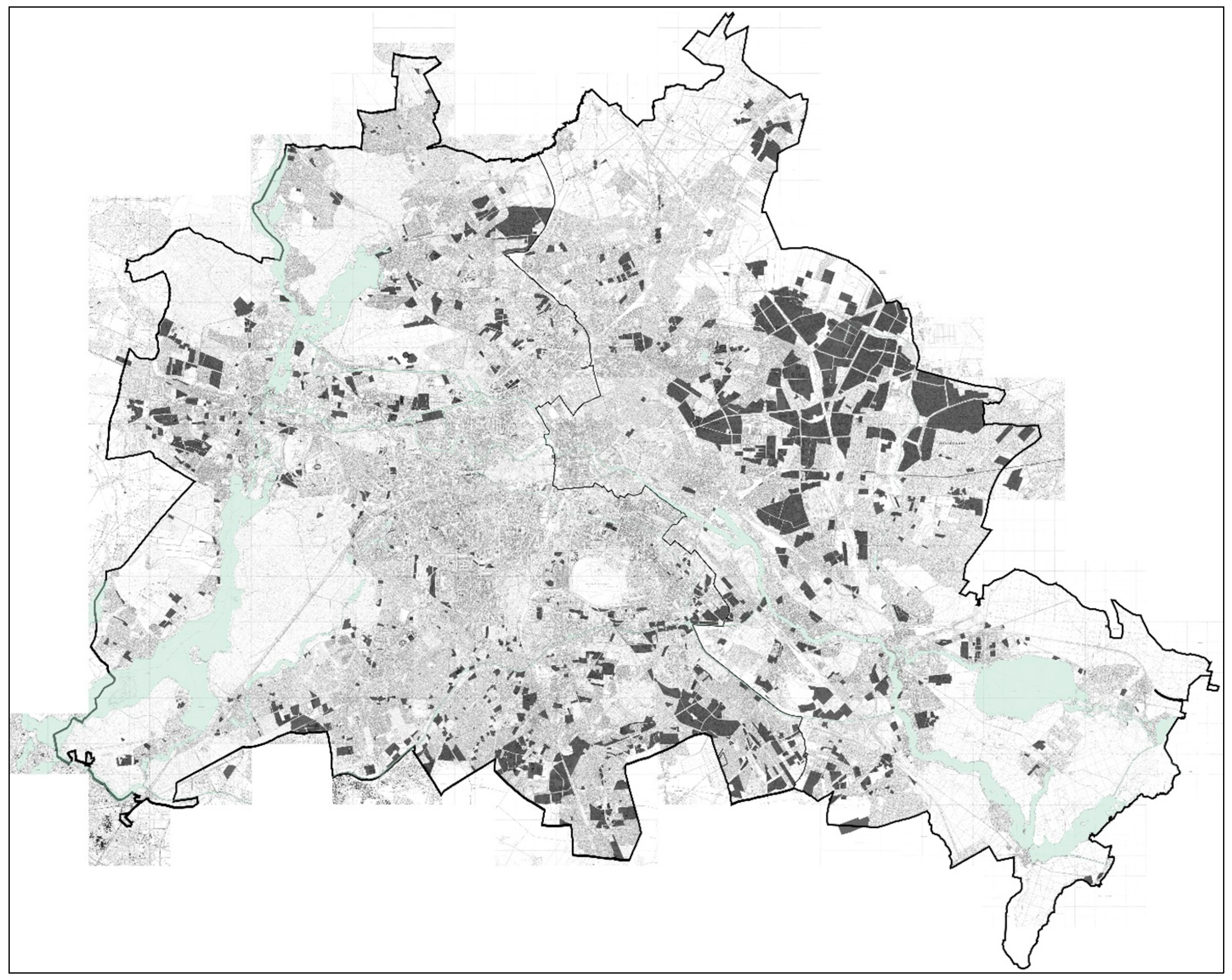
In the year 1961, the spatial containment of West Berlin was cemented by the construction of the Berlin Wall, limiting the city of West Berlin to a clearly demarcated area. This wall, a physical emblem of the division of Germany, and the practical device delimitating West Berlin, confronted all aspects of the city’s environment, from forests and lakes, to dense metropolitan districts and suburbs.
The undivided Greater Berlin had encompassed an area of 883 km
2. After the Wall, 480 km
2 belonged to West Berlin (54%), and 403 km
2 (46%) to East Berlin. In 1961, 2.2 million people lived in West Berlin, and 1.07 million people in East Berlin. The basis for this analysis is the Map of Berlin at scale 1:5000. Using maps from the years 1961 and 1990, the physical and land use changes during the period of containment was reconstructed. The sum of these are shown in
Figure 1: “Berlin 1961–1990: Newly built land”, showing the land that was newly covered, and
Figure 2: “Berlin 1961–1990: Transformation areas”. For a better understanding of the new spatial paradigm and the original composition of the city, the maps show both parts of the city.
A few key numbers draw attention to the dynamics of densification activities undertaken in West Berlin during the period of containment. Between 1961 and 1989, 36.5 km
2 of land (equal to 7.6% of the territory) was newly opened for development in West Berlin. In contrast, in East Berlin, it was 48.9 km
2 (equal to 12.1%). This indicates that the rate of new construction was higher in the uncontained East Berlin than in the contained West Berlin by almost double (
Figure 1). In addition, between 1961 and 1989, 0.037 km
2 (or 0.0076% of the urban area) of West Berlin was transformed by densification, renovation, and interventions into blocks that included a change of land use. In East Berlin, the rate of such transformations was only half: 0.017 km
2 (or 0.0042%) (
Figure 2). This indicates that in West Berlin, higher preference was given to transformation than in East Berlin, where space was not as scarce.
Figure 1.
Berlin 1961–1990: Newly built land.
Figure 1.
Berlin 1961–1990: Newly built land.
Figure 2.
Berlin 1961–1990: Transformation areas.
Figure 2.
Berlin 1961–1990: Transformation areas.
3. Urban Infrastructures
If cities are defined as the places of the densest interaction of networks, the degree to which networks are interwoven may be understood as an indicator of the degree to which a landscape is considered urbanized. These networks are important indicators of social and economic activity. In the case of Berlin, the scarcity of available space for infrastructure during the period of containment clearly affected their physical networks, influencing their layout and operability.
With the termination of the Allies’ collaboration in 1948 began the disintegration of various networks that had previously connected and serviced the entire city. Only a few elements of the pre-1948 infrastructure, namely, parts of the sewage system and the quadripartite control over air traffic, remained undivided. The task of infrastructural division, including the public transport networks, road networks, and energy and communication networks, was more or less completed by 1952. The city’s formerly unified networks of municipal services, traffic routes, public transportation, and communication facilities remained divided until reunification in 1990, even though some softening was agreed upon in the Quadripartite Agreement (1971).
Even though West Berlin had linkages to the outside world and could trade goods, some of the most crucial infrastructure had to be newly established on the ground of the city, adjusted to meet the new condition, or, if they were already located in the West, upgraded and maintained. After 1961, a number of vital small- and large-scale technical installations were built that would in other circumstances be located away from the urban center. However, in the case of West Berlin, those vital pieces of infrastructure could not be pushed out to peripheral locations, out of sight from the city. This spatial constraint led to innovations in architectural design for typically strictly utilitarian buildings, which can even today be aesthetically appreciated.
These new installations include: a new center for the City Cleaning Department (1969–1974, architect Josef Paul Kleihues), three waste incineration plants, and a phosphate elimination plant to treat drinking water (1981–1985, architect Gustav Peichl). For example, it was required to build the phosphate elimination plant in West Berlin because the water in Berlin was increasingly contaminated with phosphates, due to increased use of phosphate-based fertilizers in the drainage area of the river Spree [
11]. This plant was realized in the framework of the 1984/87 International Building Exhibition (IBA), a program designed to promote architectural design innovations in the urban context. Another example of a piece of utilitarian infrastructure which was developed as a piece of architecture is the sewage pump station in Tiergarten, by architect Oswald Mathias Ungers. Built in 1987, it resembles a little villa in the postmodern style. All three of the abovementioned waste incineration plants were also carefully designed by well-known architects [
12].
The largest new infrastructural structure that was built in West Berlin between 1961 and 1990 was Tegel Airport (1969–1971, Architects von Gerkan, Marg and Partners). A significant increase in passenger numbers was expected, but enlarging the existing Tempelhof Airport was considered impossible, since it was constrained on all four sides by the city. Since West Berlin wanted a “representative gate to the world”, a large international competition for a new airport was announced in 1966. The selected design for the airport featured a very innovative accessibility concept. As a so-called drive-in airport, passengers could approach the different gates as closely as possible by car, bus or by foot. The terminal building was designed such that a later extension would have been possible.
Thus, under the containment, various large infrastructural elements were integrated into the urban fabric of West Berlin, even if they produced adverse effects, such as noise and pollution. These negative effects had to be negotiated on the ground of the city. However, these examples can also been seen as a hybrid between infrastructure and architecture. Because they had to be located in densely built areas, they were also taken on as special design opportunities. Commissions that would normally be considered as engineering projects crossed over into the world of architecture, and many talented architects of that generation worked on these problems.
4. The Mobility Network: From Backbone to Hyper-connectivity
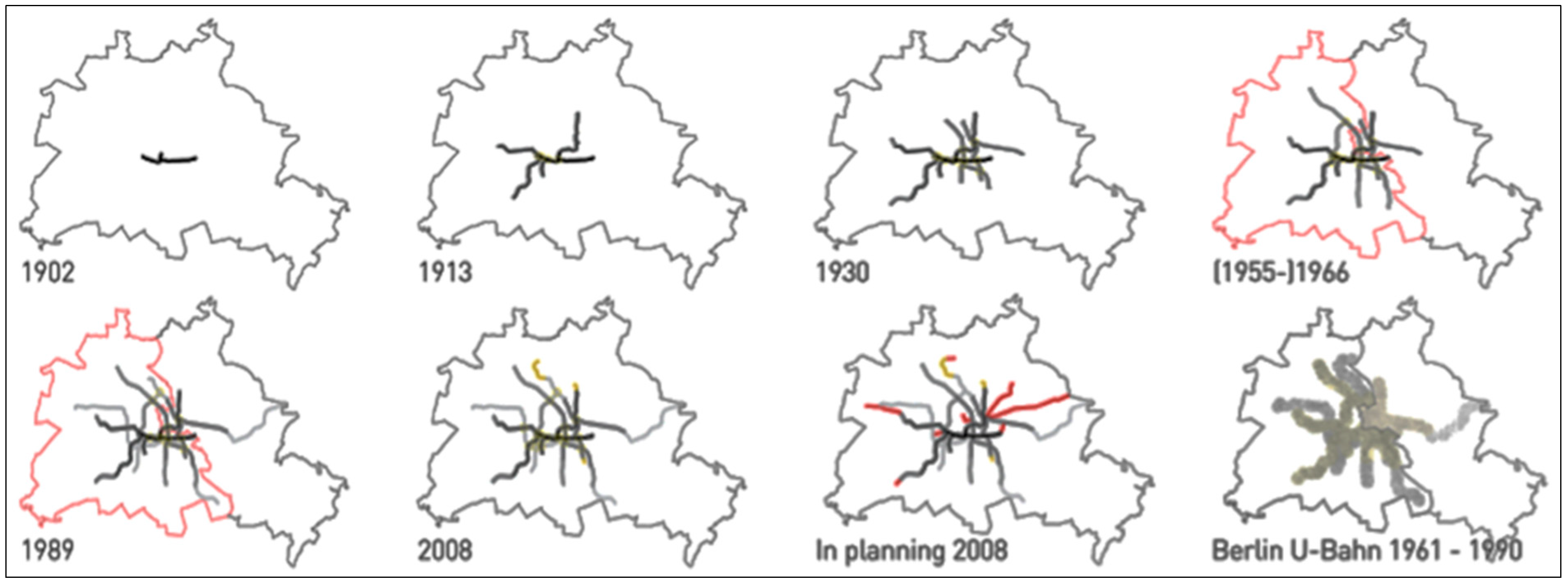
The spatial containment of West Berlin also produced a distinct effect on the layout, use pattern and spatial typologies of the mobility network. During this period, Berlin’s public transport network experienced an increase in patronage, documented by the steadily growing ridership and longer operating hours, and supplemented by technical upgrades such as electronic traffic guiding systems. In West Berlin, the spatial organization, or layout, of the U-Bahn network during this time reveals a shift, from a layout based on spatial expansion of the city (the “backbone”), to a layout based on hyper-connectivity of the city, aimed at flexibility and reinforcement of the system. This shift also resulted in a different typology of the U-Bahn station, from simple nodes and terminus, to a more complex model, providing maximal interchange possibilities.
Figure 3 illustrates how the Berlin U-Bahn network grew since its founding in 1902. In 1913, the system consisted of one “backbone” (the U1 line), from which five longer and one shorter arms extended outwards. The three longest arms connected the densely populated districts of Charlottenburg, Prenzlauer Berg, and the prosperous Zehlendorf in the southwest. In this system, there were four transfer possibilities: two allowing transfer in one direction, and the other two allowing transfers in two directions.
Figure 3.
U-Bahn-network.
Figure 3.
U-Bahn-network.
After World War I and the annexation of other municipalities to form “Groß-Berlin” or Greater Berlin, the U-Bahn network was extended to facilitate the outward expansion of the city. In 1930, Wedding, Friedrichsfelde (an industrial area at the eastern end of the city) and the new Olympic Stadium west of the city center were included into the U-Bahn network as new destinations. The network became more complex. In addition to the four interchange facilities of the original backbone structure, six new transfer stations were built. All of these provided the possibility to change to at least two other directions. From Alexanderplatz, where three lines intersected, four different directions could be chosen. During this period to until the beginning of the 1960s, the network was extended northward and southward, and one more centrally located shortcut between two existing lines was built. Only two new interchange facilities were realized, and these emerged only as a consequence of the shortcut that now connected the two older lines.
However, in the period of containment in West Berlin, there is a marked difference in the manner by which the U-Bahn network is expanded. During this period, two existing routes were extended and two new lines, the U7 and the U9, were constructed, under the “200 km Plan”. Because these two new lines each crossed all of the other already existing routes in the western part of the city, a maximum of interchange possibilities was generated. There is a shift in how the mobility network relates to the development of the city: new lines were not devices with which to extend into new, hitherto unconnected parts of the city, but rather devices that reinforced and connected parts of the existing network.
During this period, an area of hyper-connectivity emerged, in which stations exist in close proximity, and the accessibility of already well-connected areas was even more intensified. In this area, the underground network is organized like a grid, rather than a backbone. The map also shows that with the two new lines, several loops emerged from which arms extend into the periphery.
Where networks of infrastructure become loops, terminal stations become outdated as a building typology. It is interesting to note that compared to the period before 1961, only two “dead ends” or terminal stations were added to the network, even though two new lines were built. Whereas in 1966, eight lines had dead ends, in 1989, only 10 did. This indicates a higher overall integration of the network. In East Berlin, in contrast, the organizational structure of the underground network did not change much after the Wall was built. The U5 line was extended to connect the new large-scale developments towards the east (Marzahn, Hellersdorf). Trams and S-Bahn complemented the U-Bahn network.
Notably, after the Wall came down, the now-unified network did not change much in its organizational structure. Even though the trains today run on adjusted routes, and old connections that had been cut are linked again, the network structure remains more or less the same. Three lines were extended outwards, and future plans show two new lines heading eastward, following the large radial roads Greifswalder Straße and Prenzlauer Allee. In West Berlin, three lines will be extended at the end to form loops with already existing lines. Two of these extensions had been planned before 1989.
5. The 200 km Plan
I will examine the development of the U-Bahn network in the period of 1961 to 1989 in West Berlin in more detail. In 1955, six years after the founding of the two German States, and 10 years after the administrative division of the two Berlins, the BVG (the municipal transportation company) implemented the “200 km Plan” [
13] (p. 55). The plan foresaw the physical extension of the West Berlin U-Bahn network, from 80 to 200 km. In addition to the extension and alteration of existing lines, two entirely new routes were planned. One of the two lines—the U7 from Spandau in the north-west to Rudow in the southeast—was partially built on already existing tracks; the U9 leading from Wedding to Wilmersdorf, going north-south, was conceived after the separation of the city. With this plan, the main centrality of the Zoologischer Garten (or “Zoo”) in West Berlin was strengthened, since the new network structure supported this area by making it highly accessible, a point where many lines intersected. Multiple ways of interchange, inter-modal as well as between different U-Bahn lines, were provided in the area around the Zoo. From there, connections west, east, and southwest were possible. However, connections in the directions south and north were missing. For those directions, passengers used trams.
Complementing an underground line from Wedding to Tegel, by which the northern Berlin district and the important sub-center Tegel was connected efficiently to the Zoo, the need for an efficient south connection became urgent. The U9 line, providing an additional north-south connection in West Berlin, was thus the logical answer. The U9 also allowed the key strategic possibility to operate the entire West Berlin underground network independently from East Berlin, since four out of eight existing lines crossed the sector borders. Two of these lines were oriented in a north-south direction (U6, U8), and two in an east-west (U1, U2) direction. All of these lines were in operation during the years of the separation. The East Berlin underground stations crossed by these lines, for example the Heinrich-Heine-Straße stop or the Bernauer Straße stop, were so-called “spectre stations” [
14], since West Berlin trains were not allowed to stop in East Berlin. Furthermore, the stations were not accessible from East Berlin, in order to prevent defection through the tunnels. However, for almost 10 years after the Wall had been built, it remained unclear whether the passage of these U-Bahn lines would be accepted on a regular basis, and remain so in the future. The new north-south direction provided by the new U9 line guaranteed the operability of the entire network, in case the lines crossing East Berlin would be intercepted.
Between 1966 and 1974, the extension towards Walter-Schreiber-Platz in Steglitz was also realized. At the same time, the extension of the new U7 between Kreuzberg and Wilmersdorf was opened. The two lines intersected at the station Berliner Straße. In 1969, the construction of the U-Bahn began at Schloßstraße in Steglitz. The demand for that station was very high. Not only the U9, but also another projected line, the U10, was supposed to be led through the corridor below street level. In order to save on construction costs later, the tunnel was built with four tracks on two layers. In the station Schloßstraße, the tracks were arranged to be direction-sensitive: on the upper floors, the two tracks go north (towards the city center), while on the lower deck the two tracks go south, to the periphery of the city.
The section between Spichernstraße and Steglitz on the U9 line was opened in 1974. The U10 however, remained a phantom line that was never built. The plan was abandoned in 1984, when the already existing parallel S-Bahn tracks were re-integrated into the public transport network. Also in 1969, the construction of the U9 in a northerly direction progressed. In 1976 the terminal station Osloer Straße was opened. With this station another hub in the network was realized, connecting the U9 with the U8, which was extended from Gesundbrunnen to Osloer Straße [
13,
15,
16].
6. Implications on the Urban Fabric
After the Wall was built in 1961, 59 new U-Bahn stations were constructed in West Berlin. Thus, while up to the beginning of the 1960s the network grew mainly radially from an original spine or “backbone”, the organizational logic of the network itself shifted during the period of spatial containment of West Berlin. Even earlier planned outward expansions of the city (like Gropiusstadt), already existing peripheral settlements (for example Spandau), and peripheral industrial locations (for example Siemensstadt) were integrated into the network within this period. The network therefore complimented the densification of the city.
The layout of two new lines produced a new spatial pattern in which the number of interchange possibilities within the network increased considerably, because two new lines formed intersections with themselves and with already existing lines. In that way, not only an area of hyper-connectivity around the Zoo emerged, supporting Zoo’s importance as the main center of West Berlin, but also the overall flexibility of the network increased considerably. Based on the new network infrastructure, a number of loops and an U-Bahn grid emerged that allowed better connectivity and shorter routes, compared with a radial network in which all lines are guided through a central point. The overall inter-connectivity of the network increased, and the number of terminal stations decreased, relative to the number of lines and stations in operation.
Therefore, it can be stated that, during the time of spatial containment, the accessibility of existing settlements in West Berlin was improved, rather than connections to new and more peripheral places being facilitated. In that sense, West Berlin experienced a continuous densification alongside an upgrade of inhabited spaces towards better connectivity and polycentric development. Not only did the inter-connectivity within one mode of transport improve, also the connectivity with other modes of transport improved.
The example of the U-Bahn network demonstrates that the proliferation of that network, combining the two aspects of the intensification of traffic flows and the nature of the physical extension of the networks, promoted and reinforced the densification and improvement of the existing fabric of West Berlin.
7. A Culture of Urban Density
In West Berlin, between the years 1961 to 1989, space was a very scarce resource. This constraint on the city produced a number of progressive, unconventional, locally unique, and innovative spatial compositions and functional combinations during this period, and precipitated innovations at the material, architectural, and urban scales.
By approaching space in cities as a resource, urban conditions that may be otherwise be perceived as handicaps and/or difficulties force and also enable people to approach these spaces with resourcefulness, creativity, and innovation. It fosters a new culture of urban density. The examples pointed to in this paper may not always be classical examples of beautiful or grand architecture, and indeed in some cases do not always express good taste. The spatial composition—be it on the architectural or neighborhood scale—is thus interesting, not for its architectural quality, per se, but for its response to its particular spatial constraints and the possibility to trigger a new cultural practice in a dense city.
People in Berlin have accepted the mixture of traffic space and human space produced by the spatial constraints. Here, I am thinking of the historical example of the elevated U-Bahn in Kreuzberg and Prenzlauer Berg, but also examples such as the “Bierpinsel”, Schlangenbader Strasse or Kollhoff’s and Timmermann’s Seeseneer Straße apartments. The architectural design of such infrastructure-led architectures is exciting in itself, because it is not only dealing with the functional aspect of its services, but its negotiation with the dense fabric of the city. Such developments and refinements of logistic infrastructures have shaped Berlin’s spaces. In the following, I will present four examples of how the scarcity of space led to the opening of sites with very difficult conditions close to major infrastructure arteries along the S-Bahn ring and inner urban highway. They are examples of inner city densification.
7.1. Intermodal Small Scale Hub
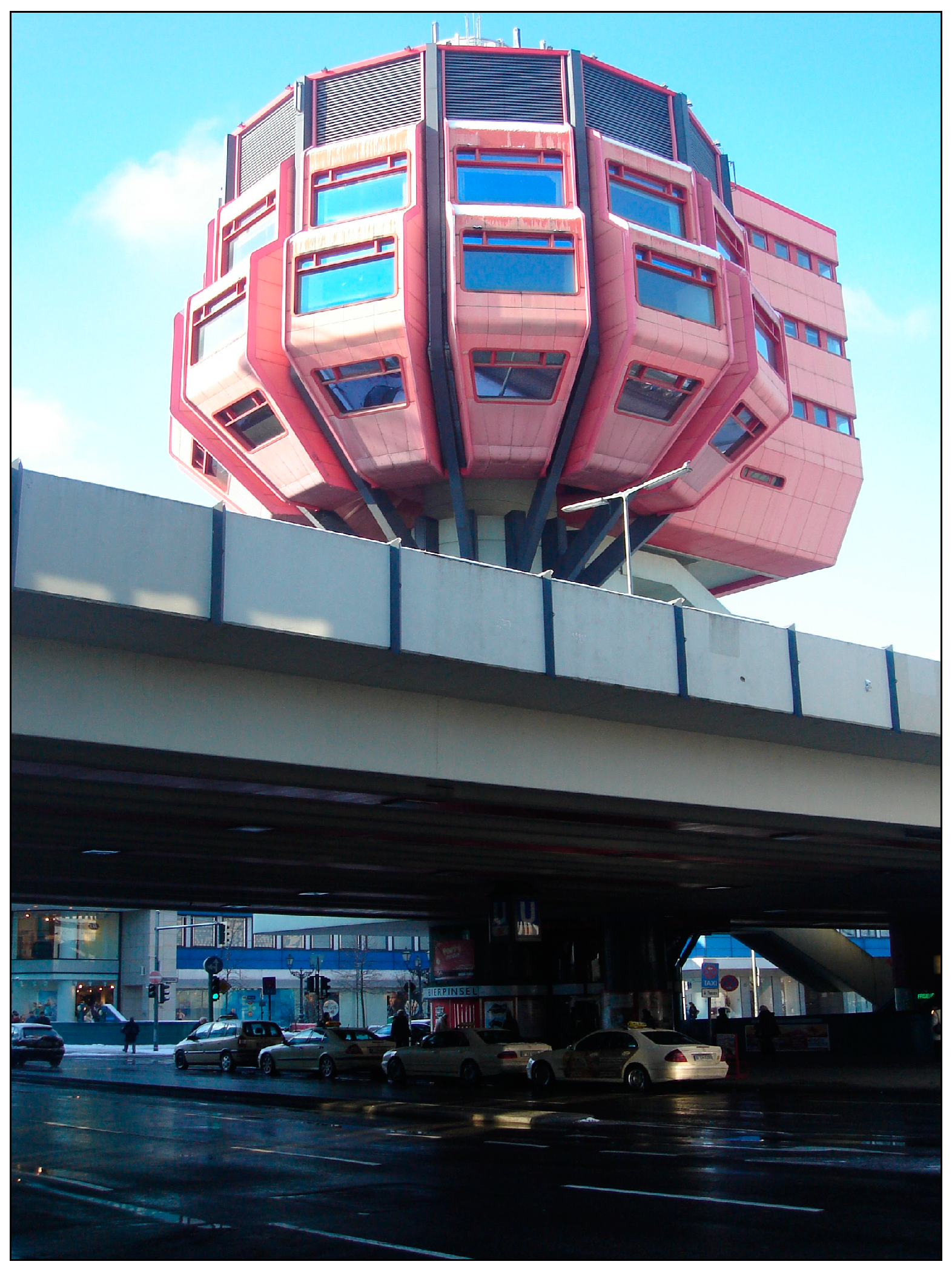
On the ground of a seemingly ordinary intersection of one of the most popular shopping streets and local centers in West Berlin, the Schloßstraße in Steglitz, two U-Bahn lines, an elevated exit road from a highway, several bus lines, and parking facilities intersect on five floors to form an inter-modal small-scale hub. As
Figure 4 shows, the 46m high tower crowning the top this conglomerate, colloquially called the “Bierpinsel”, is the iconic landmark of the intersection. This structure attempts to integrate the elevated highway exit ramp into the urban fabric of the 19th century city. This hub combines traffic infrastructure, entertainment, and consumption.
Figure 4.
“Bierpinsel”.
Location: Berlin Steglitz, Schloßstraße 17; built between 1972–1976; architects: Ralf Schüler and Ursulina Schüler-Witte.
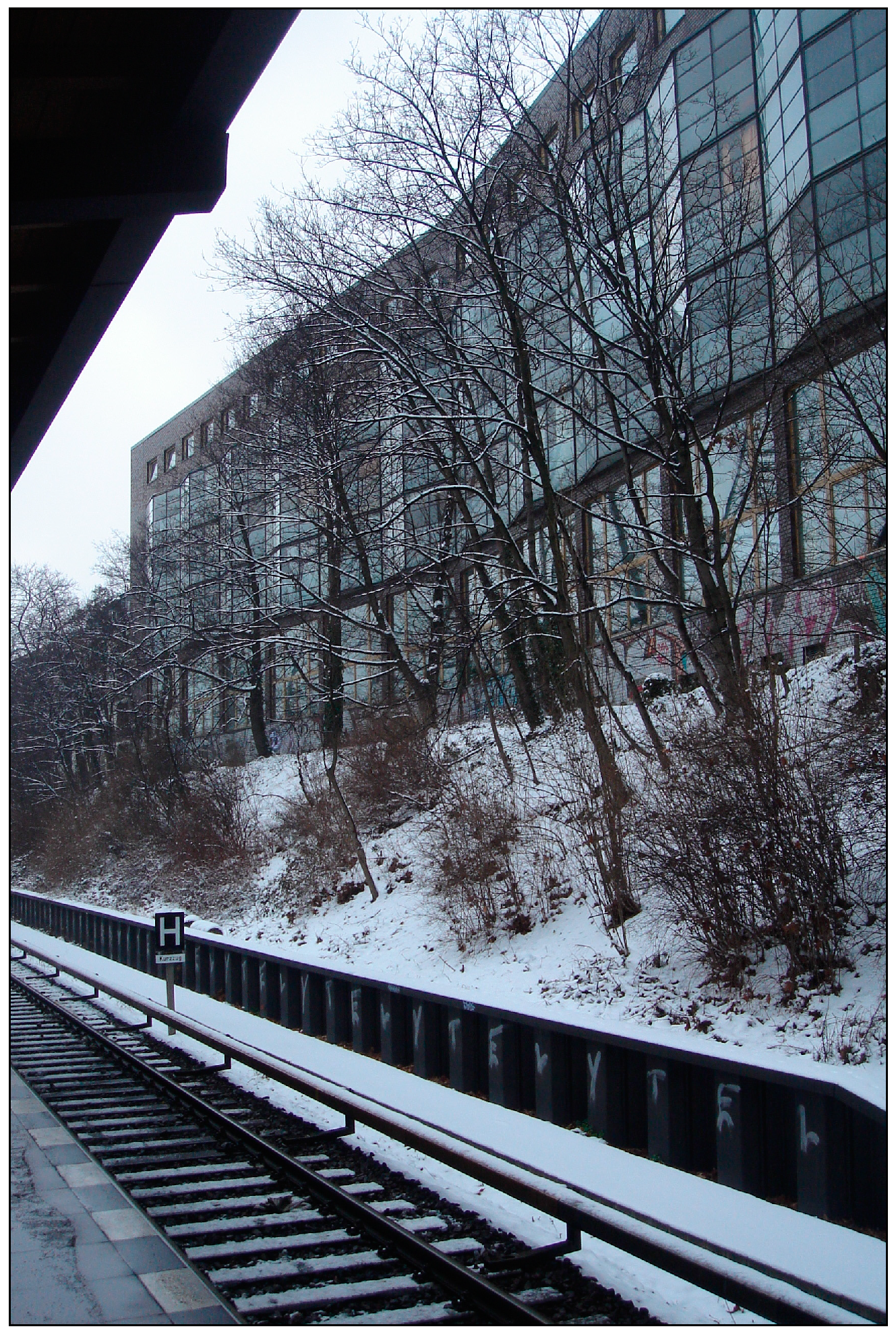
7.2. Screen Railway Apartments
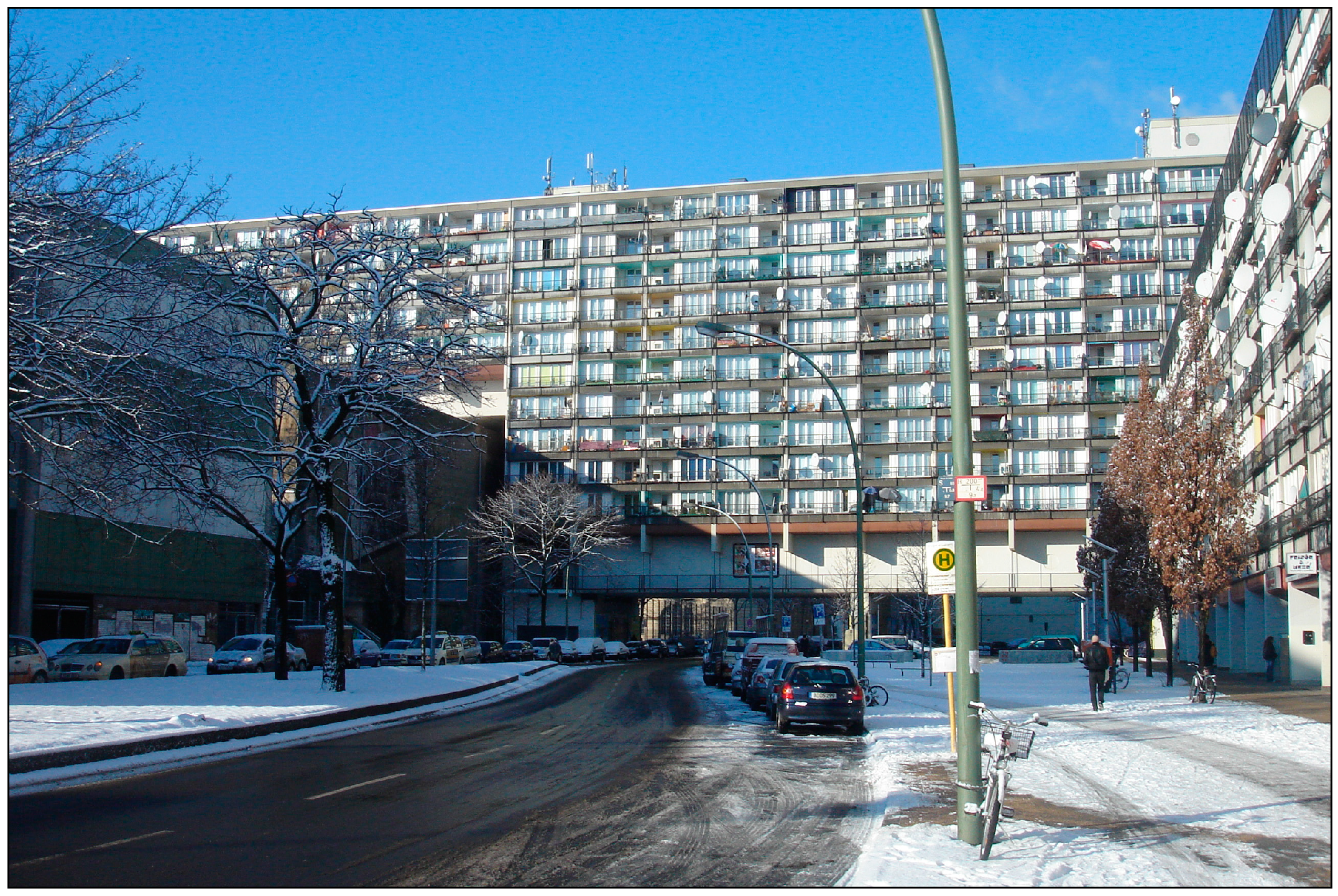
North of the S-Bahn ring and the inner urban highway, the architects Hans Kollhoff and Helga Timmermann had to solve the problem of a residential building’s exposure to extensive noise and emissions. As
Figure 5 shows, the building reacts to a very disadvantaged condition, which is brought about by its location next to a major piece of traffic infrastructure. The architects designed a long building, with a courtyard shielded from noise and emissions. As a v-shaped figure, the building reflects the sound of the S-Bahn. The apartments from the first to the third floors have screens of slightly protruding winter gardens that also mitigate sound by introducing a spatial noise buffer zone. What the building mitigates in noise emissions, it allows in view: to see the sky is a rare condition in a dense city.
Figure 5.
Screen Railway Apartments.
Figure 5.
Screen Railway Apartments.
Location: Berlin Wilmersdorf, Seesener Straße 70; competition 1988; built between 1992–1994; architects: Hans Kollhoff and Helga Timmermann.
7.3. Inhabited Bridge
The aesthetically powerful mega-structure “Residence at Kleist Park” was constructed between 1974 and 1977. As can be seen in
Figure 6, the façade is dominated by windows and balconies, creating an astonishing visual contrast with its context. In order to realize a high density, the building utilizes air rights over an existing street. From the street, a public deck can be reached, which crosses the street on +1 level.
The configuration of the three lower courtyard houses is also very dense. The building—now vernacularly called “Sozialpalast”—contains 541 apartments, leisure facilities, and shops.
Figure 6.
Inhabited Bridge.
Figure 6.
Inhabited Bridge.
Location: Berlin Schöneberg, Pallasstrasse 08; built between 1974–1977; architects: Dietmar Grötzebach and Günter Plessow with Jürgen Sawade and Dieter Frowein; Contributers: Thomas Krebs, Karl-Eugen Müller, Gustav Silde, Karin Burkat.
7.4. Viaduct
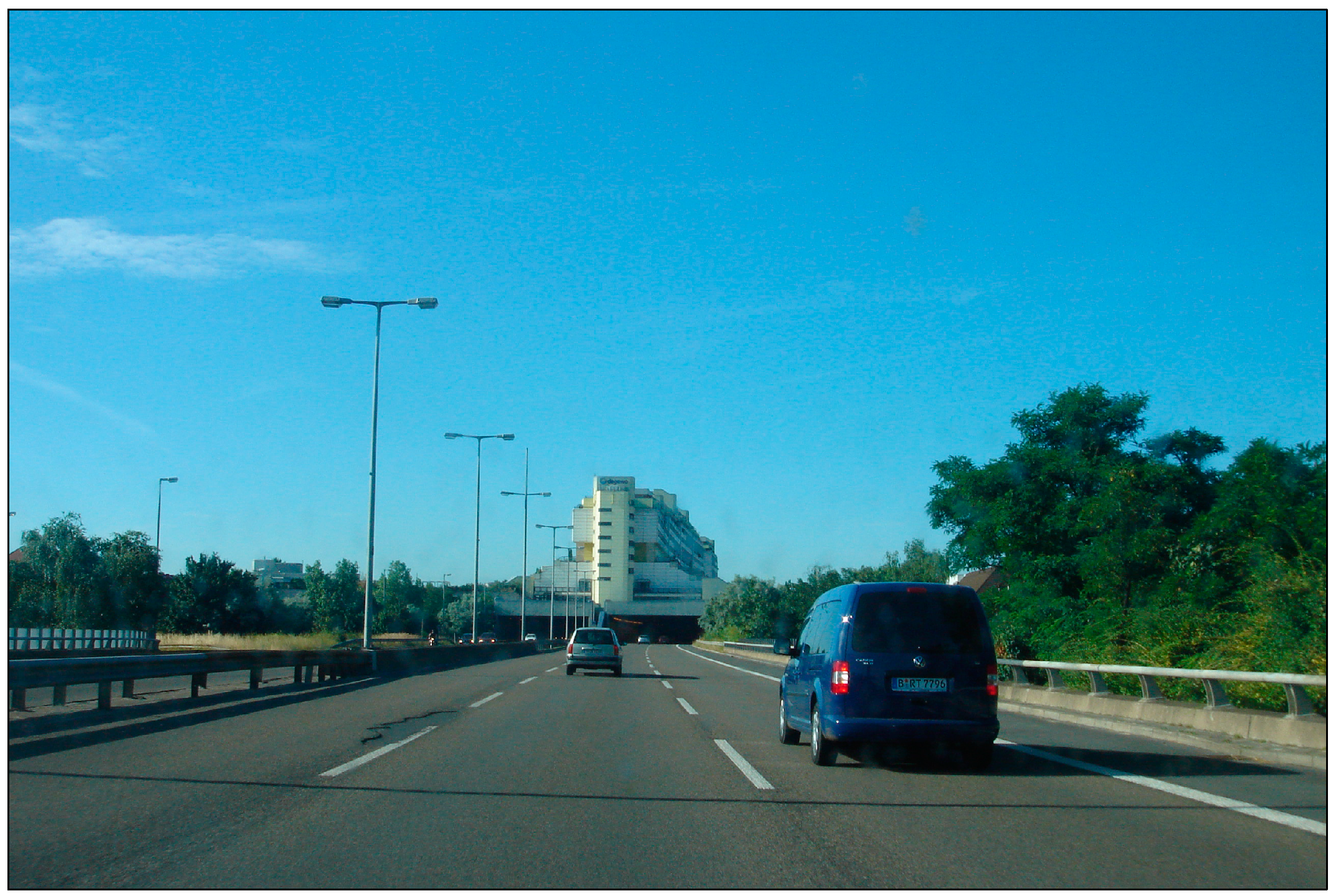
In the 1970s, architects and planners sought the integration of previously considered mutually exclusive functions in the same space,
i.e., residences and highways, with the project at Schlangenbader Straße, which is shown in
Figure 7. This highway superstructure is essentially an inhabited viaduct, covering the then newly-built highway, which cuts through in two tunnels. Structurally and acoustically, building and highway are separated. It was a pilot project for the integration of different functions on scarce building land. The building is almost half a kilometer long, and consists of 2200 apartments. At its highest point it is 14 floors high. It also protects neighboring buildings from the noise of the highway.
Figure 7.
Viaduct.
Location: Berlin Wilmersdorf, Schlangenbader Straße 12-36; Opened: 1980; Architects: Georg Heinrichs with Gerhard Krebs and Klaus Krebs; Artists: Haus Rucker & Co., Georg Seibert.
8. Conclusions
The investigation of West Berlin during the years 1961 to 1989 brings to attention the spatial and practical implications of densification strategies in an urban development: a dense layout of vital infrastructures will most likely support or trigger an urban densification. Accordingly, a study of this period of containment reveals a number of spatial paradigms of density, only a part of which has been focused on in this paper, namely, the development of its urban infrastructure and hybrid architectural and urban typologies that deal creatively with the challenges of dense urban development. These projects demonstrate the emergence of a new building culture of urban density.
The link between sustainability and density lies in the notion of space as a resource. Defining “space” (as opposed to energy) as the very resource that architectures and urban projects are foremost using and consuming provides a new angle on the sustainability discourse, by proposing a shift away from technological thinking towards a cultural practice of using and appropriating space in cities and urban landscapes. This also indicates potential links to other sustainability concepts.
From this case study, one can project into the future: as many large cities continue to grow, and as available space becomes increasingly scarce, the notion of space as a resource must be embraced by architects and planners, all the more so in this age of global exploitation of resources of all kinds. The way space is used has a direct impact on how other resources are used. Space must therefore be thought of as something that can be scarce, and something that can also be used more productively. The case of West Berlin during its period of containment reveals that for space to be productive, architects and planners should embrace unconventional combinations of uses and hybrid typologies, and aim to reinforce and improve the existing city.

