Article

Urban Land Pattern Impacts on Floods in a New District of China

1
State Key Laboratory of Lake Science and Environment, Nanjing Institute of Geography and Limnology, Chinese Academy of Sciences, 73 East Beijing Road, Nanjing 210008, China
2
University of Chinese Academy of Sciences, No.19A Yuquan Road, Beijing 100049, China
*
Author to whom correspondence should be addressed.
Sustainability 2014, 6(10), 6488-6508; https://doi.org/10.3390/su6106488
Submission received: 4 June 2014 / Revised: 15 August 2014 / Accepted: 5 September 2014 / Published: 26 September 2014
(This article belongs to the Special Issue Landscape and Sustainability)

Abstract

:
Urban floods are linked to patterns of land use, specifically urban sprawl. Since the 1980s, government-led new districts are sweeping across China, which account for many of the floods events. Focuses of urbanization impact on floods are extending gradually from hydraulic channels, to imperviousness ratio, to imperviousness pattern in urban areas or urbanized basins. Thus, the paper aims to explore how urban land pattern can affect floods in urban areas to provide decision makers with guidance on land use and stormwater management. Imperviousness was generally correlated with spatial variations in land use, with lower imperviousness in less dense, new districts, and higher imperviousness in more dense, uniform/clustered development in local areas adjacent to hot nodes. The way imperviousness and channel are organized, and the location of imperviousness within a catchment, can influence floods. Local government’s approach to new district planning, in terms of zoning provisions, has only considered some development aspects and has not adequately integrated flood management. A key issue for the planning should been done to adequately cater for flooding, particularly considering the benefits of keeping natural conveyance systems (rivers) and their floodplains to manage flood waters.

1. Introduction

The world urban-dwelling population has increased rapidly since the end of the 19th century and had rising overall percentages from 13% in 1900 to 49% in 2005, a figure expected to reach 60% in 2030 [1]. The negative environmental impacts associated with urbanization, such as loss of cultivated land and biodiversity, aesthetic degradation, and rising urban flooding are linked to the patterns of land use, specifically poorly designed and coordinated development and low-density urban sprawl [2,3], which has increased at alarming rates in many countries worldwide. Urban flooding is also the major threat to many cities worldwide, with more significant impacts on developing countries [4]. Since the early 1980s, the Chinese government launched sweeping reforms of the structure of institutions, among which, the most influential changes are the establishment of land use rights, commercialization of housing, and restructuring of the urban development, which led to rapid expansion of new districts around large cities. More than 100 cities countrywide have been “planned” into the international metropolis, and 144 prefecture-level cities in 12 developed provinces have 216 new districts. The total area of urban land increased from 12,200 km2 in 1990 to 40,500 km2 in 2010. Although new districts adopted the clear design of urban drainage system, urban land pattern has still altered natural ecosystems and accounted for much of the higher frequency of urban floods since 2008.
Urbanization impact on runoff and flood damage in urban areas is still an important area of research [5]. Initially, most studies focused on local hydraulic representation of streets and sewer system in the early 1960s [6]. Then, impervious thresholds started to be used directly as a common way to quantify impacts on hydrological process in the 1970s [7,8] and benchmarks in watershed planning efforts [9,10]. The impervious cover model defines four categories of urban streams, based on the imperviousness ratio (IR) value [9], such as sensitive streams, impacted streams, nonsupporting streams, and urban drainage. The categories have been extensively tested in ecoregions around the U.S. and elsewhere. Schueler et al. [11] proposed the reformulated changes, among which IR should be the transition band rather than a fixed line. Natural landscape can play an important role in managing flood risk. Increased imperviousness will increase runoff volume and flow rate. While there are some metrics available for measuring urban expansion [12,13], researchers have also indicated that urban imperviousness pattern and road networks within a watershed can determine changes in hydrologic function, such as the flow rate [7,8,14,15,16,17]. The dispersed or clustered characteristics of the impervious area did not affect runoff volumes, only flow rates [18]. The placement of impervious surface determines changes in hydrologic function including the speed with which surface flow enters the stream and the volume that enters the stream. In general, upstream impacts will create disturbances over longer stream length while downstream disturbances will create more concentrated impacts [19,20,21]. Yang et al. [22,23] studied hydrologic responses of watersheds to urban/impervious area and the impact of urban spatial pattern/location on hydrology, including floods in central Indiana by use of the estimated effective impervious area (EIA) as input to the Variable Infiltration Capacity (VIC) hydrology model with urban representation. This research demonstrated that the spatial pattern of urban development can affect the hydrologic regime by influencing the hydrologic connectivity of urban area at a catchment scale, while at the river basin scale it is the travel time of urban location that controls flood patterns. The distance between impervious cover and the channel appears to be one of the most important factors regarding placement, particularly for areas in which runoff is not piped directly to the stream. Imperviousness further from the stream has less impact on the hydrologic system simply by not destroying the buffer. Thus, the percentage cover, distribution, and spatial variation of imperviousness impacts on floods in urban areas, are simulated to show that the way imperviousness is organized does affect floods.
Then, more currently, there is growing interest in using the urban landscape for managing and controlling stormwater [6,7]. The effects of urbanization on land processes can be an important control, and later, the research focused on the implementation of urban planning technologies, such as LID (Low Impact Development) in North America [24,25], for which, equivalent terms such as sustainable urban drainage systems (SUDS) in the United Kingdom, water-sensitive urban design (WSUD) in Australia [26] and the Low Impact Urban Development Design (LIUDD) [27], is an alternative approach to stormwater management and avoid negative effects of conventional urban land redevelopment by using the catchment context as the design framework and encouraging the minimization and the clustering of urbanization areas to maximize surface permeability. A catchment-based structure planning approach needs to involve all professional sectors and a nested hierarchy of units for design and management [28], and should begin whilst a basin is still in its natural state [29,30,31].
Moreover, focuses of urbanization impact on floods are extending gradually from hydraulic channels, to imperviousness ratio, to imperviousness pattern in urban areas or urbanized basin. However, most Chinese studies paid more attention to land use change impacts on floods in natural basin, as well as the hydraulic design of channels in local lot scale [32,33,34]. Today’s urban planners have used the neighborhood as the dominant design unit, rarely using the catchment [27]. Little attention was paid to urban land pattern impacts on floods in urban areas [35,36]. However, high frequency of urban floods has made it necessary for a better understanding of the sustainability of urban development and planning and land pattern which rely strongly upon available information about interactions between urbanization process and hydrological system [37,38]. Thus, the study aims to gain insight into how urban land pattern can affect rising urban flooding, provide planners and decision makers with guidance on urban development and stormwater management: analyzing characteristics and driving factors of urban land pattern through a set of metrics, in terms of flooding; assessing urban land pattern scenarios impacts on floods through hydrological models.

2. Methods and Data

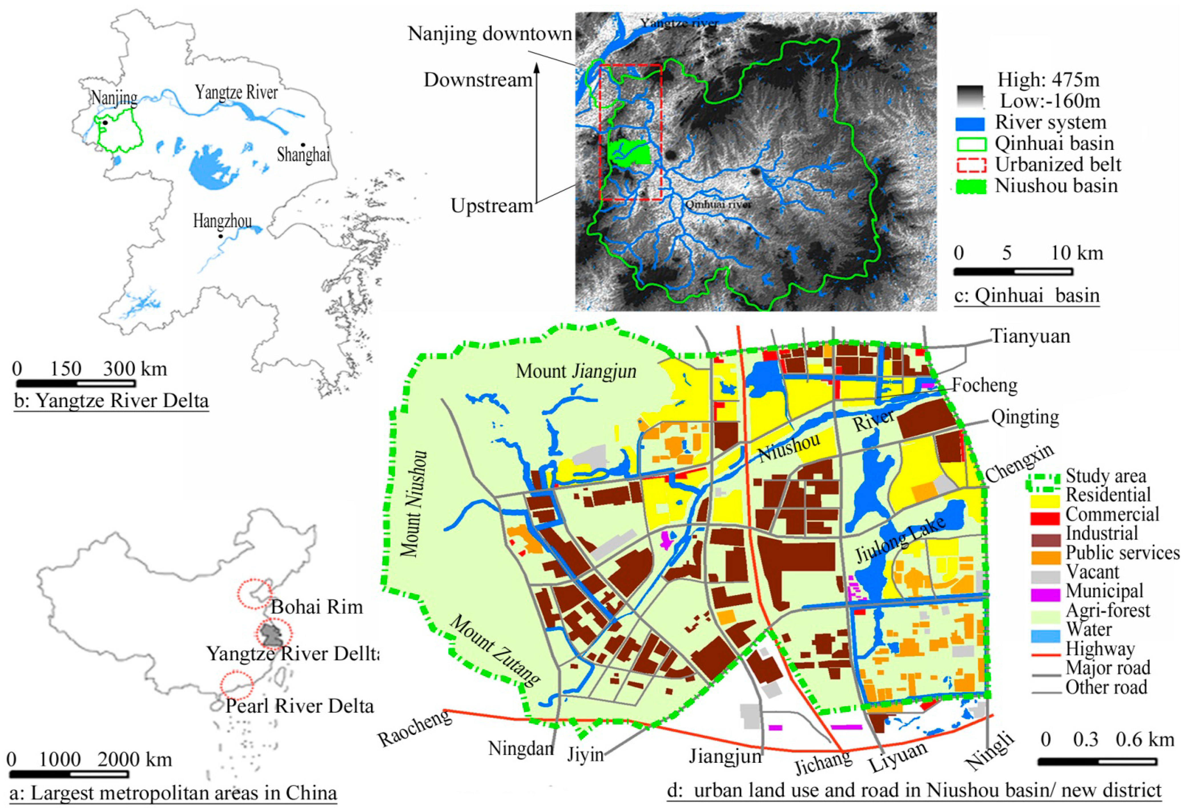
2.1. Study Area and Urban Land Use Types

The Yangtze River Delta, with an area of 99,600 km2, is centered at Shanghai city and has two sub-centers, such as Hangzhou and Nanjing (Figure 1a,b). Urban land in the Yangtze River Delta has the largest concentration of adjacent metropolitan areas in the world and surpassed two other largest metropolitan areas in China (the Pearl River Delta and Bohai Rim region). Demographia [39] shows that Shanghai, with a population of 21.76 million, is listed 5th in cities worldwide, and Nanjing, with a population of 5.77 million, is listed the 59th worldwide and the 9th in China. Nanjing downtown, with an urban land percentage of 89.9%, lies in the downstream Qinhuai basin on the Yangtze River Delta and is gradually expanding to upstream Niushou basin with urban land percentage of 62.11% (Figure 1c). Thus, the study area, with an area of 33.68 km2, refers to the new district covering the whole Niushou basin (Figure 1c), belongs to the north subtropical monsoon climate zone with a yearly average temperature of 17.8 °C and an amount of yearly precipitation of 1034 mm, and adopts the clear drainage system in Urban Master Plan [35].
Each land use including its imperviousness was obtained by the SPOT5 (France name as Systeme Probatoire d’Observation dela Tarre-5) imagery and actual land plan data about greening rate (Figure 1d). Overall accuracy (OA) and kappa coefficient (Kappa) are used to evaluate the land use classification results, which have indicated that the OA, Kappa of the classifications were 86.22%, 0.844 for images in 2010, and also were compared with land use maps of Urban Master Plan (1996–2010). The paper selected ten random samples in each land use for the accuracy assessment through the site investigation. Residential and mixed-use patches with the regular form were compared with the polygons on land use plan maps to check up the accuracy of land use patches obtained by SPOT5 image. The accuracy of other types depends on a variety of factors, therefore is checked up by the site investigation and survey. All urban land uses have an overall accuracy of over 85%.
Figure 1. The location of the study area and its land use types in 2010.
Sustainability 06 06488 g001

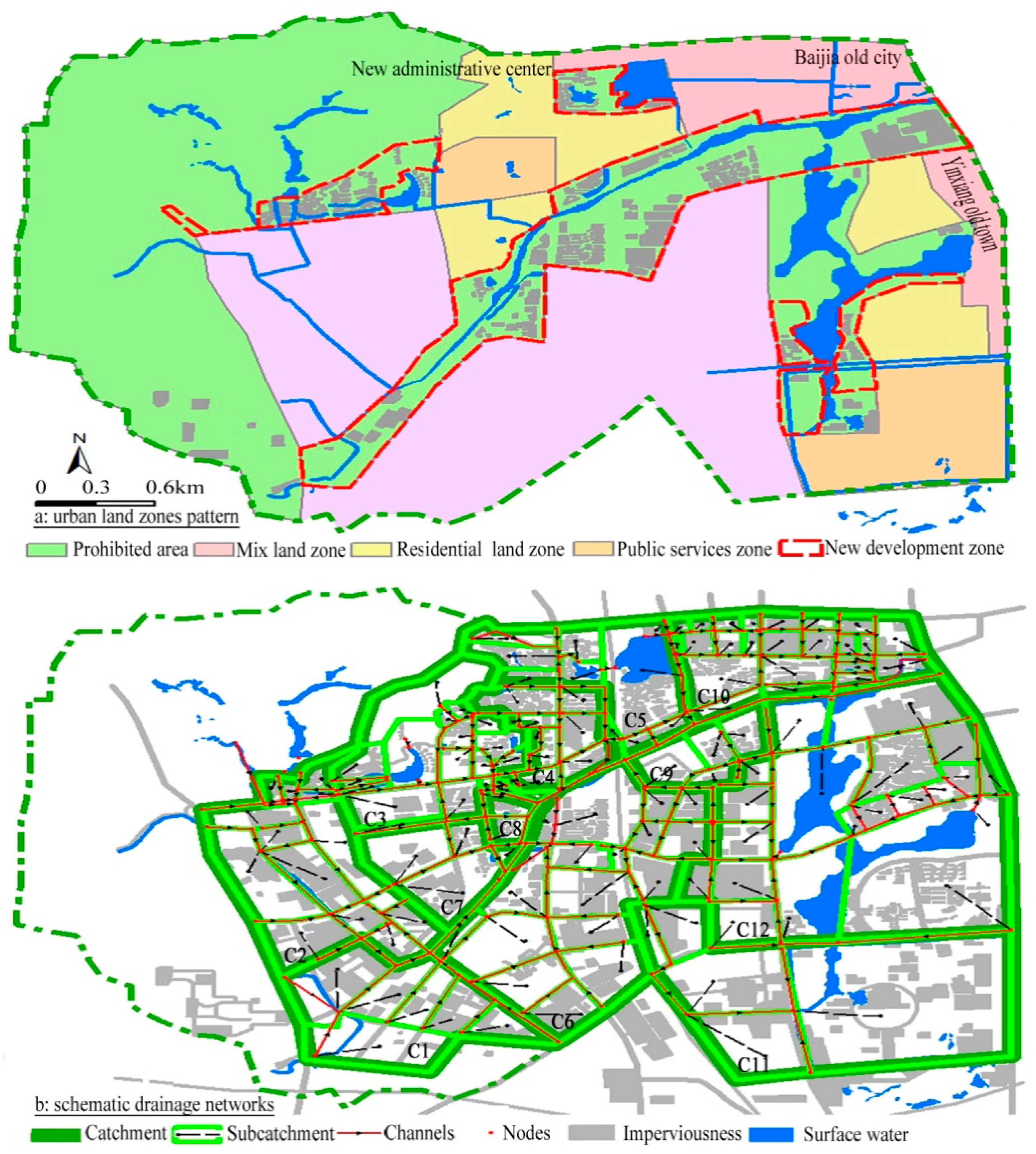
2.2. Urban Zones and Drainage System

Urban land pattern in new district is organized through land zoning laws, which may include regulation of the kinds of activities, which will be acceptable on urban zones. Urban zones are determined by the Land Suitability Evaluation Technology (LSET) to overlay the multiplicity of factors affecting urban activities in any location based on the use of map overlays [40]. The district is divided into the prohibited development areas and suitable development areas including mix, residential, industrial, public services, etc., zones (Figure 2a). There are three development hot nodes including the Baijia old city (BJ), Yinxiang old town (YX), and new administrative center (AC), which further led to three development hot belts including the high-density mix zones along Tianyuan road and Ningli road, the high-density mix zones along Ningli road and the high-density residential zones along Jiangjun road. Other industrial and public services zones have presented a low-density and dispersed pattern since 2003. Although the initial planning (1996–2010) preserved some hydrological sensitive areas, in also supplied redundant urban land exceeding actual land demand, and three new development zones (NDZs) including along the northern Focheng road, along Niushou River and around Jiulong Lake have also broken through the planned boundaries of the prohibited areas. The latest planning (2011–2030) not only legalized current three NDZs in the prohibited areas. It also directly altered some prohibited areas (other NDZs in Figure 2a) into suitable development areas.
Figure 2. Configuration of urban zones and drainage system in the study area.
Sustainability 06 06488 g002
Then, based on urban zones and road network, a set of plan control units (e.g., residential, industrial lots) is formed and regulates their plot ratio, greening rate, and civic facilities, among which an urban drainage system attaches itself to urban zones/land pattern and also represents a nested hierarchy of drainage units, i.e., subcatchment, catchment, and basin (Niushou basin). An urban catchment is composed of land subcatchments (equivalent to plan control units), conduits (pipes and channels) and nodes (manholes and outlets) directly. Thus, based on the real urban drainage system from the data in Urban Master Plan (1996–2010) and Arc Hydro Tools in the ArcGIS software, the urban drainage system in the study area is digitized and converted into the schematic drainage networks including an urban basin (Niushou basin), 11 catchments, 128 subcatchments, 223 channels with an area of 361 km and 239 nodes (Figure 2b): the urban basin collected the rainfall flow into the Niushou River; urban catchment and subcatchment have their own independent drainage system and also are greatly restrained by the framework of land zones and roads.
Thus, the urban catchment with a regular form was enclosed by roads and cannot completely follow the natural flow routes and catchments with an irregular form enclosed by contours, based on the three-meter resolution DEM from the Data Exchange and Sharing Platform of Lake and Watershed of Chinese Sciences Academy (Figure 3a). Moreover, based on the spatial relationship between urban drainage lines and natural flow lines within the subcatchment, an urban catchment is divided into the conflict part (CP) and the conflict-free part (CFP).
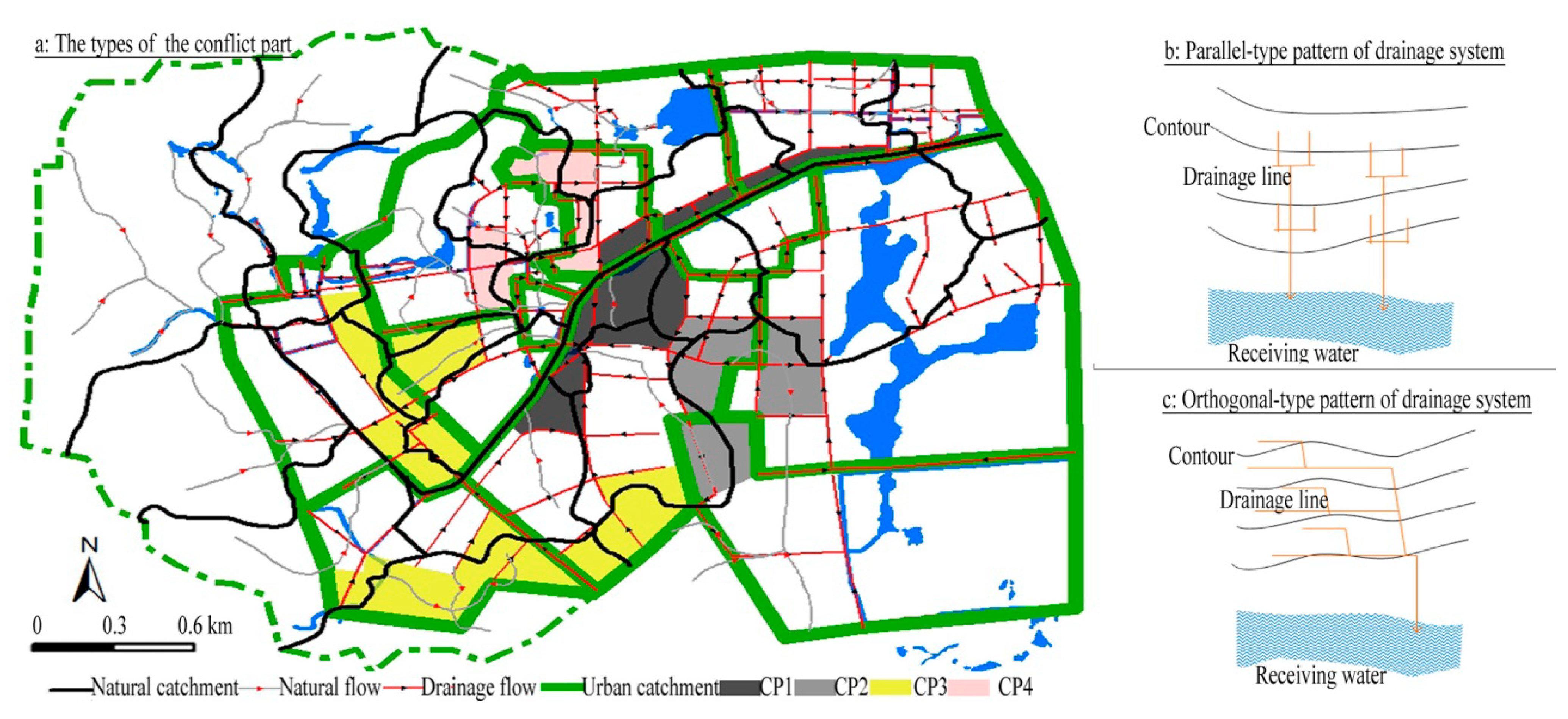
  • The CP drainage lines against natural flow lines fall into four categories of patterns (Figure 3a). The CP1 lies in the belts adjacent to the downstream Niushou River dams, where the roads parallel to the river absorb massive floodwaters and even make floodwaters back flow into adjacent residential lots. The CP2 lies in the downstream lowlands with indistinct flow routes, easily leading to floods. The CP3 lies in the upstream, uneven topographic areas. The CP4 results from the cut of natural flow lines between different urban land zones only connecting own pipes with the municipal lines.
  • The CFP drainage lines mostly following natural flow lines fall into two categories of patterns. One is a parallel-type pattern with the main channel parallel to the contours in catchment, such as the C2, C4, C7, C9, where the main channels are commonly at intersections between different natural catchments and regarded as the flood intercepting trenches to absorb floodwaters from upstream rapid flow-rate sub-channels into the receiving water (Figure 3b). In addition, the belts along the slow flow channel with many lowlands adopt flooding measures, such as flyovers, pumps, and elevated works. The other is an orthogonal-type pattern with the main drainage channel perpendicular to the contours in the catchment, where urban zones are commonly located at hillsides or are elevated through work (Figure 3c). Roads and channels are the rapid flood passages and have the greatest floods pressures at their outlets.
Figure 3. Types of urban drainage system pattern.
Sustainability 06 06488 g003

2.3. Urban Land Pattern Metrics in Terms of Urban Floods

The imperviousness pattern affects flow rate and is expressed frequently using the terms dispersed/clustered, upstream/downstream, and distance of imperviousness from channels in the literature [7,8]. Our approach follows Batty’s concept of form as a result of function [41]. The application of the concept in the field of urban land and stormwater management focuses on impacts of urban form, such as the amount and location of imperviousness on urban function, such as hydrologic services in urban areas.
  • Each catchment falls into three parts, i.e., downstream, middle, upstream, by the main stem of the channel/stream, and is estimated the clustering degree of imperviousness in vertical dimension (parallel to the main stem of the channel/stream) (CL-V) via Equation (1), where Xi for area percentage of imperviousness in each part (e.g., upstream) and X for average area percentage of imperviousness over the catchment. The CL-V equals 0 when imperviousness is maximally disaggregated in three parts, and increases as imperviousness is increasingly aggregated in some parts.
    CL-V = 100[∑(Xi − X)2/3]0.5
  • Each catchment falls into two parts, i.e., adjacent and non-adjacent, by the main channel buffer with its radius, r, based on the mean size of all subcatchments S, i.e., r = S0.5 = 42.01 m, and is assessed the clustering degree of imperviousness in horizontal dimension (orthogonal to the main channel) (CL-H) via Equation (2), where Xi for area percentage of imperviousness in each part (e.g., adjacent) and X for average area percentage of imperviousness in two parts. The CL-H equals 0 when imperviousness is maximally disaggregated in two parts, and increases as imperviousness is increasingly aggregated in the adjacent part.
    CL-H = 100[∑(Xi − X)2/3]0.5
  • Each catchment falls into four parts by elevation breaks of 4 m, 13 m, and 22 m based on ArcGIS. Firstly, the surfaces ≤13 m and surfaces >13 m are defined as lowlands (L) and hillsides (H), respectively. Secondly, according to the area ratio of lowlands and hillsides in the catchment, each catchment falls into three categories, such as L%, H%, LHr, where L% is regarded as a low-elevation-led catchment with its lowlands area ratio of over 80% (e.g., L85 means that the area ratio of lowlands in the catchment is 85%) and, moreover, the H% referring to a high-elevation-led catchment with hillsides area ratio of over 80%. However, if both L% and H% are less than 80% in the catchment, LHr means that there is not an obvious leading elevation area, where r is the ratio of hillsides area to lowlands area in the catchment. Lastly, which elevation area does the imperviousness incline to move to? The I-E-D (Imperviousness elevation distribution) is calculated by subtracting the actual ratio of imperviousness in the catchment from its lowlands area ratio (m shows the subtractive value) to measure the elevation characteristics of imperviousness pattern: The I-E-D is greater than 1 and labeled as L-m when the imperviousness is maximally disaggregated in lowlands in the catchment, and increases as the imperviousness is increasingly aggregated in lowlands; The I-E-D is less than −1 and labeled as H-(-m) when the imperviousness is maximally disaggregated in hillsides in the catchment, and increases as the imperviousness is increasingly aggregated in hillsides; If the I-E-D is between −1 and 1 and labeled as 0, the imperviousness spatial feature corresponds to states of the catchment elevation by the leading DEM.

2.4. Effects of Patterns of IR on Flooding Based on Modeling Runs

The United States Environmental Protection Agency (EPA) Storm Water Management Model (SWMM) [42] is a dynamic rainfall-runoff-subsurface runoff simulation model used for single-event to long-term (continuous) simulation of the surface/subsurface hydrology quantity and quality from primarily urban/suburban areas. The EPA and other agencies have applied SWMM widely throughout North America and through consultants and universities throughout the world. Spatial variability in all of these processes is achieved by dividing a study area into a collection of smaller, homogeneous watersheds or subcatchments.
Firstly, each subcatchment, all channel/pipe and nodes in Niushou basin based on the drainage system provided by the Urban Master Plan, Urban Planning and Civic Engineering Bureau of Jiangning, Nanjing were manually digitized and converted into GIS databases as the input data of SWMM model. The databases include the location of inlets, length, sized and flow direction of each channel. The DEM spatial data combined with the GRID module of ArcGIS were used to compute the subcatchment and channels/pipes slopes. The slopes were then used to compute the impervious depression storage coefficients. More information on the methodology is available [42].
The second step determined empirical coefficients through related reference materials [43]. The max/min rates and decay constant was respectively for 76.2 mm/h/3.18 mm/h and 0.0006, and the depression storage/Manning’s roughness in impervious and pervious subareas respectively 5 mm/0.015 and 7 mm/0.030. In the channel flow process, the channel Manning’s roughness of the artificial masonry and natural grassy, respectively, is 0.017 and 0.03.

3. Results

3.1. Urban Land Use Pattern Characteristics

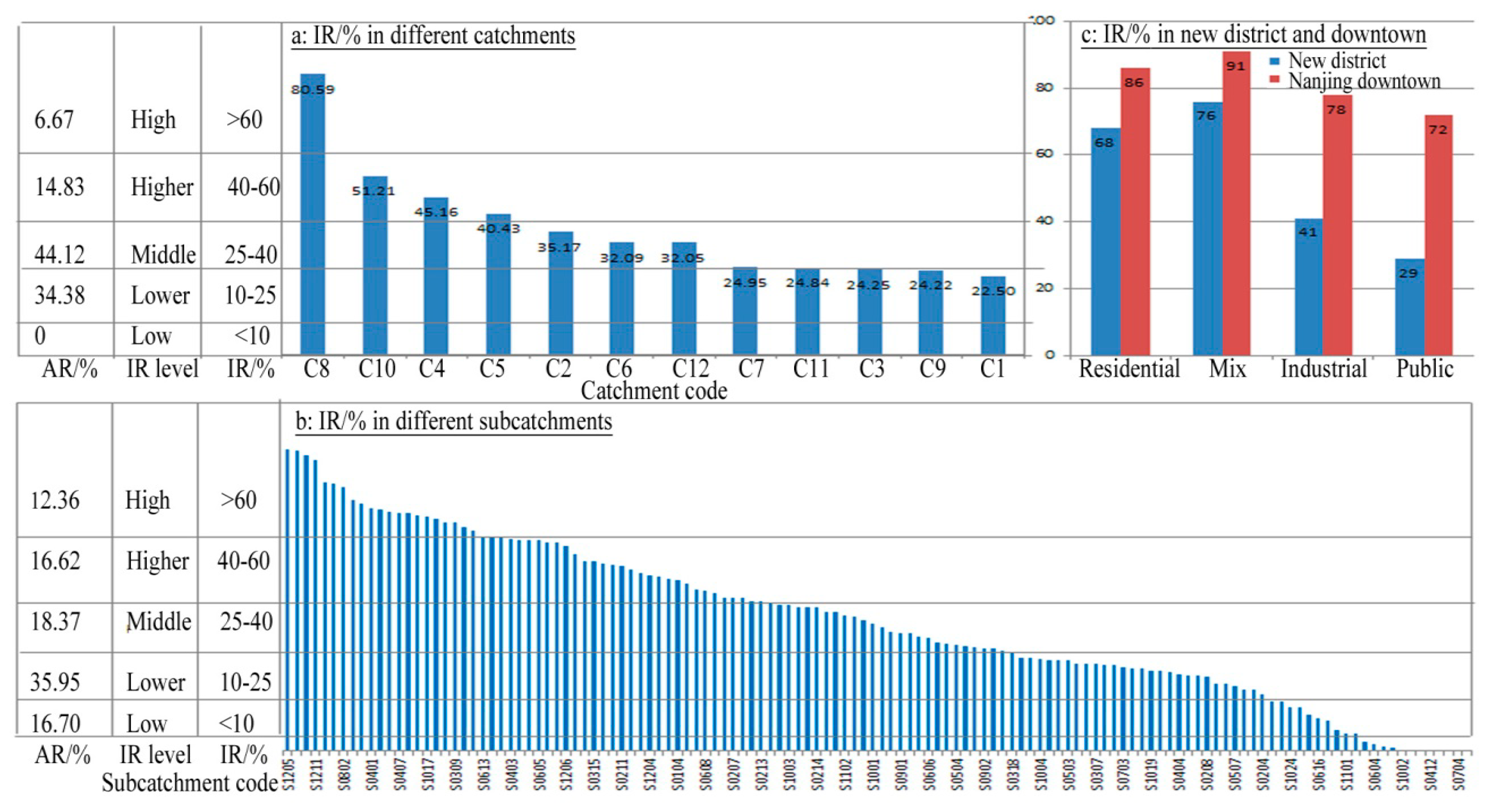
3.1.1. Imperviousness Ratio

The catchment C0, with only few of tourist facilities, has the lowest IR of 0.96%. Three large reservoirs with bank and intake gate hold against floods and often make the downstream natural streams dried-up in dry season but overflow in rainy season based on visual observations and measurements data of runoff volume at the Hohai Meteorological Station during 2000–2009. The suitable development area includes C1-C12, which has a mean IR of 31.97%. According to Table 1 and Figure 4a, high-density catchments exceeding the IR 40% include the C4, C5, C8, and C10 and almost follow the regulated land use type and density in Urban Master Plan. Middle-density catchments with the IR30-40% include the C2, C6, and C12 and are mostly covered by industrial and residential land. Low-density catchments with the IR 20–25% include the C1, C3, C7, C9, and C11 and are covered by industrial and residential land under construction. The AR (area ratio) of 52.65% of the total area of all subcatchments has an IR less than 25% (Figure 4b). The IR in earlier-developed mix and residential zones is relatively higher but still lower than that of Nanjing downtown [44] (Figure 4c). However, the industrial and public land with a lower-density IR covered most of the study area. Thus, the study area generally represents a lower-density development pattern and an obvious IR variation because of the differences of urban zones types and development process.
Table 1. Imperviousness ratio characteristics.
CatchmentC9C12C5C3C7C10C6C1C2C11C8C4
IR [%]24.2232.0540.4324.2524.9551.2132.0922.5035.1724.8480.5945.16
CL-V [-]28.724.923.620.86178.968.2824.4724.4722.781.411.25
CL-H [-]50302022351016355107.525.32
Mean DEM [m]7.15.712.313.79.99.610.819.713.37.15.310.8
Leading DEM [m]L95.8L96.7LH1.34LH1.53L82L92.7LH1.99H87.9LH1.87L96.7L100LH1.97
I-E-D [-]0H-2.40L-10.2L-3.3H-3.9L-5.8L-6.6L-3.5000
Pattern typesCCMPH-CLMPCCH-CUMPCCL-CUL-CUH-CUH-CU
1985 water ratio [%]10.8120.8715.8412.1319.263.3910.369.9524.3718.2525.4611.09
2010 water ratio [%]10.3415.1315.583.554.962.451.460.730.332.0214.432.72
Channel density [km/km2]2.102.613.693.732.995.423.093.153.551.368.975.85
Main typesResiMixResiResi/indusIndusMixResi/indusIndusIndusPublicResiMix
Figure 4. Imperviousness ratio characteristics in different spatial units.
Sustainability 06 06488 g004

3.1.2. Imperviousness Pattern

Imperviousness patterns fall into five categories based on the CL-V and CL-H (Table 2). The high-density catchment uniform pattern (H-CU) with low CL-V (≤10), low CL-H (≤10) but high IR includes mix and residential land-led catchments C8, C10, C4. The higher-density catchment local uniform pattern (H-CL) with high CL-V (≥20), high IR, and middle CL-H (<20 and ≥10) includes the residential land-led catchment C5. The low-middle-density catchment uniform pattern (dispersed, L-CU) with the low value of the CL-V, CL-H, and IR includes the residential and public services-led catchments C11 and C2. The higher-density mix pattern of local uniform and channel clustering (MP) with greatly different values of both CL-V and CL-H and a higher IR includes catchments C3, C6 and C12 covered by a massive water surface and unused land. The channel clustering pattern (CC) with high CL-H (≥20) but low IR includes residential and industrial-led catchments C1, C7 and C9 in the initial development phase.
Table 2. Imperviousness pattern types and characteristics.
Pattern typesH-CUH-CLL-CUMPCC
IRHighHigherLow-middleHigherLow-middle-high
CL-VLowHighLowLow-middle-highLow-middle-high
CL-HLowMiddleLowLow-middle-highHigh
Land-led typesMix-Resi.Resi.Resi.-publicUnused-waterResi-indus.
CatchmentC8, C10, C4C5C11, C2C3, C6, C12C1, C7, C9
High-tech industrial park and livable settlement are regarded as two functions of the new district, under the guidance of which residential, industrial and public (campus) land dominate urban expansion from hot nodes to hot belts to infilling development. The nodes BJ and YX with a good location and well-grounded development firstly were developed in the earlier years. Small-size residential lots have been developed into the higher-density uniform pattern strictly following the planning regulations, but also break through the growth boundaries to still expand into prohibited areas. However, larger-size industrial and public lots had high vacancy rates but low economic benefits and public service effectiveness. In summary, the imperviousness pattern characteristics are closely related to planning urban zones types and development intensity.
The catchment C0 in upstream mountains is the highest in altitude. The C1 is in elevated hillsides of Zutang Mountain and concentrates industrial land on the belts along main channels with the I-E-D value of L-6.6, which means that much of actual imperviousness lies in the lowlands (Table 1). Adjacent to the C0, the downstream catchments C2, C3, C4, C5, and C6 as typical piedmont plain features have the LHr ranging from 1.34–1.97. Higher-density imperviousness is uniformly distributed and especially clustered in lowlands along the channels in catchments C2, C3, and C6 with an I-E-D of L-3.5, L-10.2, and L-5.8, respectively, but the C4 and C5 with the I-E-D of zero. Other catchments lie in the low-elevation, downstream of the Niushou River, where vast imperviousness expanded to the waterfront areas. However, due to the land shortage, the high-density C10 has no choice but to expand to unused hillsides. In summary, the initial rural settlements and urban development were concentrated on the 13–22 m elevation areas, but, since 2000, the urban imperviousness rapidly expanded to the lowlands with the L82.8 and I-E-D of L-8.9. The current industrial imperviousness in the initial phase mostly lies in elevated areas, but the mix and residential land mostly lie in and will also continue to expand to lowlands with waterfront landscape attracting real developers.

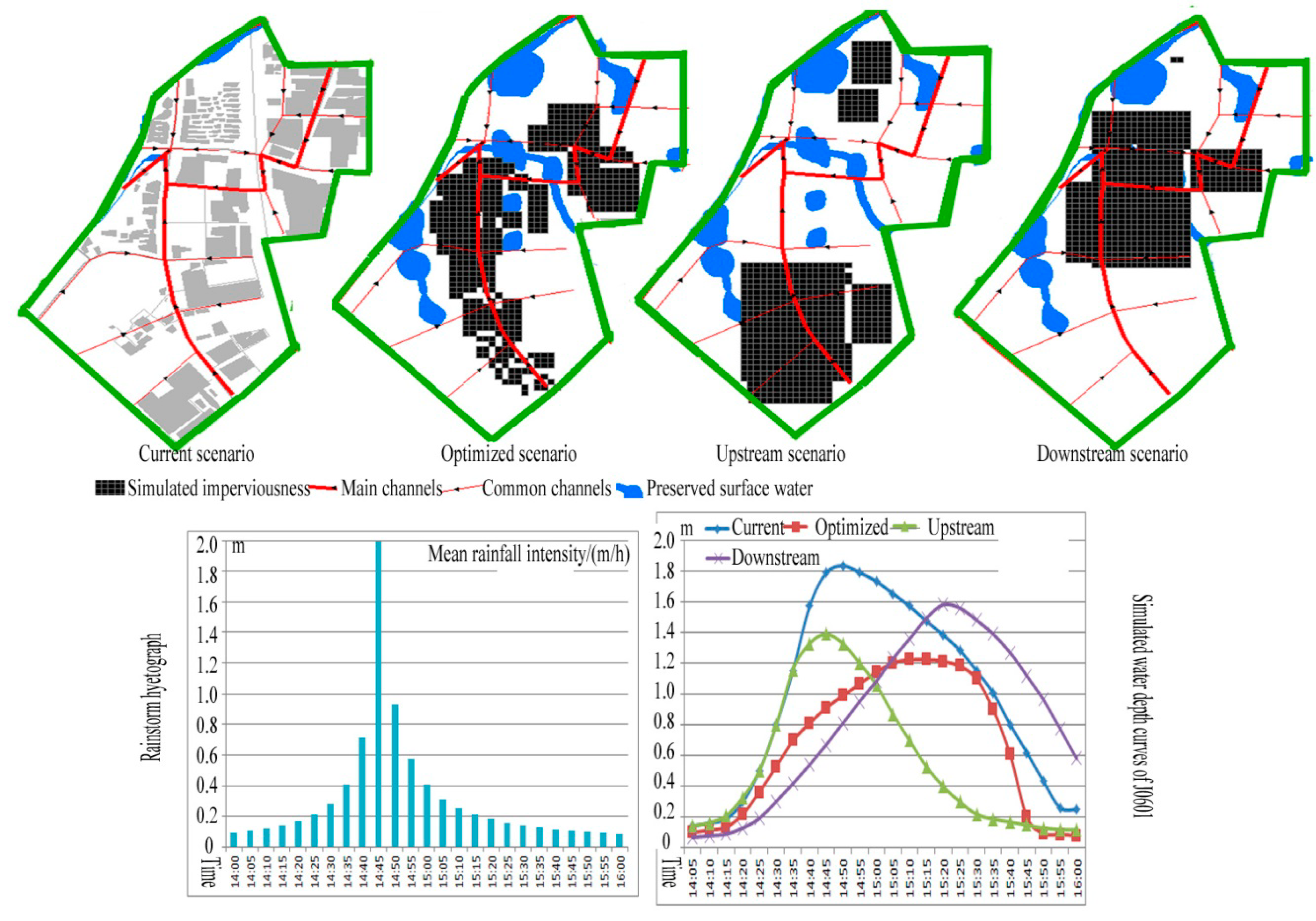
3.2. Effects of Patterns of IR on Flooding Based on SWMM
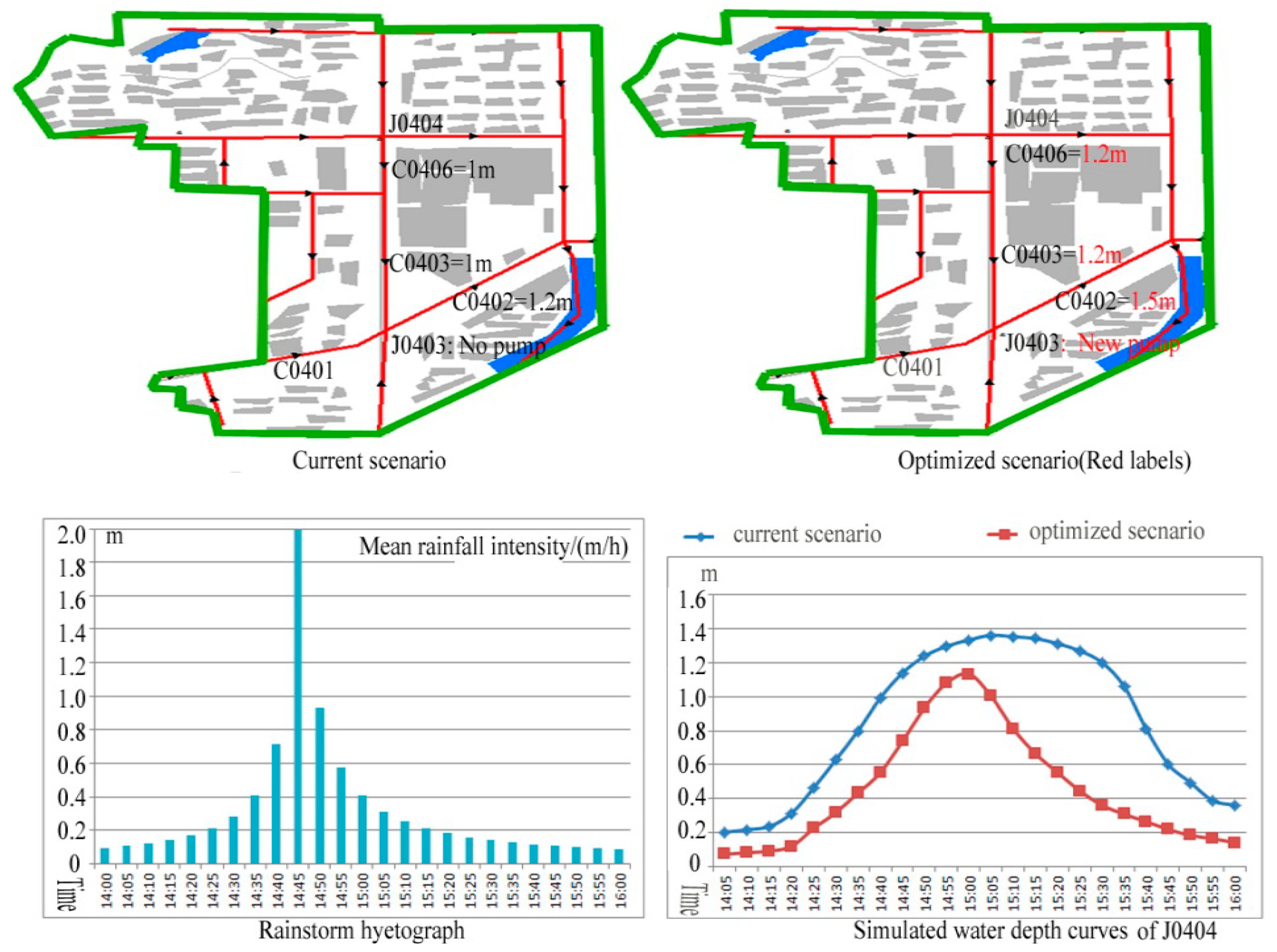
Firstly, we adopt time serials of rainfall intensity based on storm intensity i = 17.9 (1 + 0.671 lgT)/(t + 13.3) 0.8 (mm/min) and Chicago approach to design the storm hyetograph (Figure 5c), where the recurrence interval T is for five years, the rainfall duration t is for 2 h (14:00–16:00), the rain peak coefficient for 0.4 and the time step for 5 min. A typical rainstorm event, for example, 5 July 2007 (rainfall duration 2 h, total rainfall of 107.5 mm) and the monitoring data at the hydrological station of Hohai University (J0404 in Figure 5a) were used for a calibration of model parameters. Monte-Carlo method and Nash- Sutcliffe efficiency coefficients was adopted to estimate and compare the simulation and monitoring results. The Nash-Sutcliffe efficiency coefficient of calibration events was 0.87 (generally an effective value greater than 0.7) [45].
Secondly, based on the imperviousness ratio and patterns, typical catchments C4 with a high-density catchment uniform pattern and the parallel-type channels pattern and C6 with a middle-density local uniform/channel clustering pattern and an orthogonal-type channel pattern are selected to simulate and measure impacts of imperviousness-drainage patterns on urban floods.
The current pattern in the C4 showed the floods areas at the outlets J0404 (Figure 5). The 1-m-diameter J0404 and its downstream pipes, with very gentle slopes, are key factors causing floods. Thus, the optimized pattern enlarges the C0406 and C0403 from 1 m to 1.2 m, supplements a pump at the J0403, and enlarges the C0402 from 1.2 m to 1.5 m (Figure 5). The simulation results showed that the water depth was always lower than 120 mm without the overflows occurrence.
Figure 5. Simulated floods in different scenarios in catchment C4.
Sustainability 06 06488 g005
All C6 scenarios, only with the placements being changed, simulated the water depth at outlet J0601 with a diameter of 120 mm (Figure 6). The current scenario as the actual imperviousness pattern: The high-density imperviousness at the downstream outlet and upstream highlands causes a sharp rise and general decline of the water depth. The overflow emerged at 14:30 before rainfall peak, lasted nearly one hour until 15:30 (Table 3). Optimized scenario with the high-density development in a 500 m-buffer of two downstream main channels, low-density development in a 100 m-buffer of the upstream main channel preserved natural vegetation. The water depth, always lower than 120 mm without overflows, arrives at the top value at 15:10 and then declines sharply after 15:35. The upstream scenario with the high-density development in a 500 m-buffer of the upstream main channel preserved downstream vegetation. The water depth rises slowly to overflow until 15:20 and declines slowly at 15:45. The downstream scenario with the high-density development in a 500 m-buffer of two downstream main channels preserved upstream vegetation. The water depth rises rapidly to the maximum value as the runoff peak emerges at 14:45, and then declines rapidly at 14:55.
Figure 6. Simulated floods in different scenarios in catchment C6.
Sustainability 06 06488 g006
Table 3. Simulated depths (m) in scenarios of urban imperviousness pattern.
CatchmentThe catchment C4The catchment C6
Time\ScenariosCurrentOptimizedCurrentOptimizedUpstreamDownstream
14:050.200.070.140.100.140.07
14:100.220.080.160.120.170.08
14:150.240.090.190.140.210.09
14:200.310.120.300.220.330.13
14:250.460.220.500.360.500.19
14:300.630.320.800.530.800.30
14:350.800.431.150.701.160.42
14:400.990.551.570.811.330.54
14:451.140.741.790.911.390.67
14:501.240.931.830.991.330.81
14:551.301.081.791.071.200.96
15:001.331.131.731.141.061.09
15:051.361.001.651.200.871.23
15:101.350.811.571.220.701.36
15:151.340.671.481.220.531.49
15:201.310.551.381.210.401.58
15:251.270.451.281.180.301.56
15:301.200.361.151.100.221.48
15:351.060.311.010.900.191.39
15:400.810.260.810.610.171.27
15:450.600.220.620.200.151.12
15:500.490.180.430.090.130.96
15:550.390.160.260.090.120.78
16:000.360.140.250.080.120.58
The main reason for the decrease and delay in peak flows from the optimized scenario is because the current scenario and downstream scenario tend to concentrate imperviousness near the outlet and produce a faster response and higher peak flows at the outlet. The upstream scenario results in the delay and also higher peak flows at the outlet. Thus, the C6 in the developing phase should be optimized, only by the way of urban land pattern, will be organized in future and the C4 in the developed phase should be optimized by improving the discharge ability of channels system. In summary, the way imperviousness and channel are organized, and the location of impervious surface within a basin or catchment, can influence floods: favorite control measures for the orthogonal-type pattern include the channel clustering pattern, preserving a certain vegetation, lowlands, flood discharge rivers, and pump facilities at the outlets; effective parallel-type pattern encourages dispersed land placements in elevated areas, preserving a certain storage spaces, directly connecting pipes to main channels and pump facilities.

4. Discussions

4.1. Causes of Impacts of Urban Land Pattern on Floods

A variety of researchers have also acknowledged the importance of impervious surface location within a watershed [8]. The dispersed or clustered characteristics of the impervious area did not affect runoff volumes, only flow rates [18]. The placement of the impervious surface determines changes in hydrologic function including the speed with which surface flow enters the stream and the volume that enters the stream. Upstream impacts will create disturbances over a longer stream length while downstream disturbances will create more concentrated impacts [19,20]. Yang et al. [23] studied the impact of urban spatial pattern/location on hydrology, including floods in Central Indiana by use of the estimated effective impervious area (EIA) as input to the Variable Infiltration Capacity (VIC) hydrology model with urban representation. This research demonstrated that the spatial pattern of urban development can affect the hydrologic regime by influencing the hydrologic connectivity of urban area at a catchment scale, while, at the river basin scale, it is the travel time of urban location that controls flood patterns. Imperviousness farther from the stream has less impact on the hydrologic system simply by not destroying the buffer. Natural landscape can play an important role in managing flood risk [7,8,16,17].
Thus, the causes of forming patterns of imperviousness should be understood by Chinese policies and planning historical background, and create opportunities to invest in actions that can reduce the risk of flooding.
  • The rapid land development of new districts contributes to the local governments’ dependence on land-originated revenues and economic-led development policies. Dispersed urban development is a powerful top-down government-driven process in China, but a direct bottom-up economic-driven consequence in U.S. Sprawl is rooted in obvious attractions, such as good location, low land prices, housing, and availability [46,47], which also exit and cannot play a role in attracting more population to move there due to poor public facilities, such as education, entertainment and medical treatment of the residents. Inner city has obvious decentralization forces, such as high levels of taxation, small apartments, urban diseases, and lack of open space [48,49,50], however, Chinese inner cities still maintain a rapid development through urban renewal and attracts more people to live. New district development results directly from the powerful government-led development policies and Nanjing downtown development restructure reforms, including the implementation of Economic Development Area in 1992, the administrative-level transition of the county to the district in 2000, land and housing policies and investments in infrastructure during 1996–2003. In response to the global economic crisis in 2008, local government adopted the policies of stimulating housing market. Furthermore, high levels of taxation and land replacement in Nanjing downtown led to an obvious economic decentralization. In addition, the new district imperviousness pattern is closely relevant to spatial variations of attracting factors in a new district, including distance from old centers, location, availability, and public facilities. Two ‘hot nodes’ of BJ and YX are driven by factors such as good location and old development centers. Administrative center transition policy, beautiful landscape, and good accessibility led to the high-density AC and its southern belts along Jiangjun road. Downtown campus land replacement policy and natural landscape lead to the NDZs in the prohibited areas. High-tech industrial park policy and relatively poor location result in the low-density industrial and public services areas with a high vacancy rate since 2003.
  • Urban planning has not played a very strong role in controlling urban land development, for instances the land supply exceeding actual land demand, breakthrough of the growth boundaries, unbalanced development pattern and low economic benefits/occupancy rate. The industrial land has been sold out until 2003, but had a low plot ratio (i.e., the gross floor area that you are allowed to build on) and a high vacancy rate (values range from 0 to 1). The plot ratio and vacancy rate are 0.61 and 0.74 in 2003, 0.66 and 0.72 in 2007, 0.69 and 0.68 in 2010, which cannot meet the responding plan control value, i.e., 1 and ≤0.45. The output value is 300–400 CNY/m2 in 2003 and 450 CNY/m2 in 2010, which are lower than that of Nanjing downtown with 750 CNY/m2. The housing price per square meter increased from 2000 in 1998, to 3000 in 2003, to 5000 in 2007, to 10,000 in 2010 in response to the different-period policies. Thus, local government has an incessant enthusiasm for lucrative land sales, and sold out 365,000 m2 of land in 2010, 60.6% and 32.5% of which, respectively, are used as the residential and resi-mix use, and the other only for the commercial land. However, the lack of public facilities and unbalance between working and residential population lead to the low occupancy rate/plot ratio referring to respectively 15%/1.2 in 2003, and 20–35%/1.4 in 2007, and 30–60%/1.6 in 2010, which are less than the plan control value of ≥60%/1.0–3.5. 40%, 30%, 15% and 15% of dwellers in housings are respectively from local villagers, local workers, and young citizens from downtown and real estate speculators. When the education systems, housing stock, and overall community quality are improved, many more communities may have the opportunity to become attractive to the market place. In summary, the formation of a urban subcatchment pattern is greatly restrained by the framework of the land zones and roads which reorganize the rainfall flow routes by underground drainpipes and pumps. The LSET always emphasizes the engineering conditions and regional economic needs. Actual urban land development with more investments on visible traffic infrastructure than on invisible sewer pipes breaks through the planned growth boundary.
  • The drainage system planning has also design factors affecting flooding. The CPs results from the regular pattern of urban zones and the links of regional cities-economic system and mainly adopts the parallel-type pattern with longer and indistinct routes, which are prone to lead to higher frequency of floods along the main stem of channels. The belt along main channels commonly has been the concentration of residential land due to the good conditions, such as natural landscape and accessibility.
Therefore, local governments’ approaches to new district planning, in terms of zoning provisions, have only considered some development aspects and have not adequately integrated flood management. Urban drainage planning has also not been adequately integrated into development strategies and land zone plans.

4.2. Suggestions on Floods Relief for Urban Planners and Stormwater Managers

Understanding causes of forming patterns of imperviousness and information on impacts of imperviousness patterns on flooding will create opportunities to invest in actions that can reduce the risk of flooding for an urban planner and stormwater manager. A better planning protocol needs, not only the application of advanced technologies and various scientific sectors, but also holistic development strategies. Encouragingly, the government has issued guidelines on urban infrastructure construction and scientific, practical, and control of urban planning. The guidelines provides a framework that urban planning must obey the primary principle of underground infrastructure prior to ground buildings and involve the LID ideas and SWMM models in a succession of units.
  • The urban subcatchment should be integrated with the planning control unit in land use and drainage infrastructure. A more favorable urban land pattern should use the catchment context as the design framework and encourage the minimization and the clustering of urbanization areas to maximize surface permeability. A key issue for the planning should be done to adequately cater for flooding, particularly considering the benefits of keeping natural conveyance systems (rivers) and their floodplains, to manage flood waters. Particularly, the upstream catchments have the potential to provide the capacity for surface storage and infiltration to control runoff volume and flow rate by the combination of maintaining a certain area of natural vegetation and soil, additionally, the downstream catchments promote the capacity for the surface storage and discharge to carefully select development “hot areas” and improve drainage hydraulic efficiency along main channels and conceiving waters [7,8].
  • Three current top-down planning approaches should be turned into three interactive planning approaches, including aspects of urban development, and land and drainage planning: Land-driven urban development requires a rational balance between urban land supply and demand to avoid an empty town of buildings aggregation; The government-dominated planning could then become a coordinated effort between the government’s role as plan authority, planner’s role in plan rationality, and public participation to ensure plans are realistic. Drainage planning could change in two ways. Firstly by amending the planning process to ensure that drainage infrastructure is considered at the same time, or in advance, of development layout. Secondly by integrating detention (storage) and retention (infiltration/volume loss) into stormwater management to ensure that drainage planning cannot be only a water conservancy project.

5. Conclusions

The paper proposed the imperviousness pattern metrics in terms of flooding and assessed urban land pattern characteristics: The study area generally represents a lower-density and an obvious spatial variation of imperviousness ratio due to the differences of urban zones types and development process; The current industrial imperviousness, mostly, is in the initial development phase and lies in relatively elevated areas, but mixed-use and residential imperviousness mostly is in the developed phase and will continue to expand to lowlands; with the combination of the IR, imperviousness patterns fall into five categories including high-density catchment uniform pattern with mixed-use and residential land-led catchments C8, C10, C4, higher-density catchment local uniform pattern with the residential land-led catchment C5, low-middle-density catchment uniform pattern with residential and public services-led catchments C11 and C2, higher-density mixed-use pattern of local uniform and channel clustering with catchments C3, C6 and C12, and channel clustering pattern with residential and industrial-led catchments C1, C7 and C9 in the initial development phase.
Based on catchments C4 and C6 with typical pattern features and SWMM model, the paper revealed the effects of imperviousness-drainage patterns on urban floods. The way imperviousness and channel are organized, and the location of imperviousness within a catchment, can influence floods: catchment C6 in the developing phase, has a middle-density mixed pattern of local uniform/channel clustering and the orthogonal-type channel pattern, and should be optimized mainly by way of urban land patterns; catchment C4 in the developed phase, has a high-density catchment uniform pattern and the parallel-type channel pattern, and should be optimized through the improvements on channel systems; especially, favorite control measures for the orthogonal-type pattern include adopting a channel clustering pattern of developed urban land in future, preserving a certain vegetation, lowlands, flood discharge rivers and pump facilities at the outlets, and the effective parallel-type pattern encourages dispersed land placements in elevated areas, preserving certain storage spaces, directly connecting pipes to main channels and pump facilities.
In the background of Chinese economic development and urban planning, we further found that local governments’ approach to new district planning, in terms of zoning provisions, has only considered some development aspects and has not adequately integrated flood management. Urban drainage planning has also not been adequately integrated into development strategies and land zone plans. The rapid land development and the formation of dispersed patterns in new districts contributes to the local governments’ dependence on land-originated revenues and economic-led development policies, including the implementation of Economic Development Area in 1992, the administrative-level and center transition policies in 2000, and housing policies and investments in infrastructure during 1996–2003, the policies of stimulating housing market after 2008. Under the above developmental policies, actual urban land development, with more investments in visible traffic infrastructure than on invisible sewer pipes, breaks through the planned growth boundary.
Finally, the paper proposed suggestions on floods relief for urban planners and stormwater managers: A key issue for the planning should be to adequately cater for flooding, particularly, considering the benefits of keeping natural conveyance systems (rivers) and their floodplains to manage flood waters; Particularly, upstream catchments have the potential to provide the capacity for surface storage and infiltration, to control runoff volume and flow rate by the combination of maintaining a certain area of natural vegetation and soils, and the downstream catchments promote capacity for surface storage and discharge to carefully select development “hot areas” and improve drainage hydraulic efficiency along main channels and conceiving waters. Land-driven urban development requires a rational balance between urban land supply and demand to avoid an empty town of building aggregation. Government-dominated planning could become a coordinated effort between the government’s role as plan control, the planner’s role in plan rationality, and public participation, and ensure that plans are realistic; By amending the planning process to ensure that drainage infrastructure is considered at the same time, or in advance, of development layout, and, then, by integrating detention (storage) and retention (infiltration/volume loss) into stormwater management to ensure that drainage planning cannot be only a water conservancy project.

Acknowledgments

We would like to thank the Michigan State University, Guo Chen for helpful comments and edits, and Yingbao Yang for advances about the use of SWMM model. This work was supported by the National Natural Science Foundation of China (nos.41171429) and the Program for Frontier Research Issues in Chinese Academy Science (No. NIGLAS2012135022).

Author Contributions

Weizhong Su developed the original idea and contributed to the research design for the study. Gaobin Ye was responsible for data collecting. Shimou Yao and Guishan Yang provided guidance and improving suggestion. All authors have read and approved the final manuscript.

Conflicts of Interest

The authors declare no conflict of interest.

References

  1. World Population Prospects: The 2004 Revision; Department of Economic and Social Affairs, United Nations: New York, NY, USA, 2005.
  2. Pauleit, S.; Ennos, R.; Golding, Y. Modeling the environmental impacts of urban land use and land cover change—A study in Merseyside, UK. Landsc. Urban Plan. 2005, 71, 295–310. [Google Scholar]
  3. Chaves, M.L.; Camozzato, A.L.; Eizirik, C.L.; Kaye, J. Predictors of Normal and Successful Aging among Urban-Dwelling Elderly Brazilians. J. Gerontol. Ser. B 2009, 64, 597–602. [Google Scholar]
  4. Haase, D. Effects of urbanisation on the water balance—A long-term trajectory. Environ. Impact Assess. Rev. 2009, 29, 211–219. [Google Scholar]
  5. Isidoro, J.M.G.P.; de Lima, J.L.M.P.; Leandro, J. Influence of wind-driven rain on the rainfall-runoff process for urban areas: Scale model of high-rise buildings. Urban Water J. 2012, 9, 199–210. [Google Scholar]
  6. Delleur, J. The Evolution of Urban Hydrology: Past, Present, and Future. J. Hydraul. Eng. 2003, 129, 563–573. [Google Scholar]
  7. Mejía, A.; Moglen, G. Spatial Patterns of Urban Development from Optimization of Flood Peaks and Imperviousness-Based Measures. J. Hydrol. Eng. 2009, 14, 416–424. [Google Scholar]
  8. Brabec, E.A. Imperviousness and Land-Use Policy: Toward an Effective Approach to Watershed Planning. J. Hydrol. Eng. 2009, 14, 425–433. [Google Scholar]
  9. Schueler, T.R. The importance of imperviousness. Watershed Prot. Tech. 1994, 1, 100–111. [Google Scholar]
  10. Shuster, W.D.; Bonta, J.; Thurston, H.; Warnemuende, E.; Smith, D.R. Impacts of impervious surface on watershed hydrology: A review. Urban Water J. 2005, 2, 263–275. [Google Scholar]
  11. Schueler, T.; Fraley-McNeal, L.; Cappiella, K. Is Impervious Cover Still Important? Review of Recent Research. J. Hydrol. Eng. 2009, 14, 309–315. [Google Scholar]
  12. Riitters, K.; Wickham, J.; Coulston, J. Use of road maps in national assessments of forest fragmentation in the United States. Ecol. Soc. 2004, 9. Article 13. [Google Scholar]
  13. Jaeger, J.A.; Bertiller, R.; Schwick, C.; Müller, K.; Steinmeier, C.; Ewald, K.C.; Ghazoul, J. Implementing landscape fragmentation as an indicator in the Swiss Monitoring System of Sustainable Development (MONET). J. Environ. Manag. 2008, 88, 737–751. [Google Scholar]
  14. Vorosmarty, C.J.; Green, P.; Salisbury, J.; Lammers, R.B. Global water resources: Vulnerability from climate change and population growth. Science 2000, 289, 284–288. [Google Scholar] [PubMed]
  15. Pielke, R.A. Land Use and Climate Change. Science 2005, 310, 1625–1626. [Google Scholar] [PubMed]
  16. Allan, D.; Erickson, D.; Fay, J. The influence of catchment land use on stream integrity across multiple spatial scales. Freshw. Biol. 1997, 37, 149–161. [Google Scholar]
  17. Wang, L.; Lyons, J.; Kanehl, P.; Bannerman, R. Impacts of Urbanization on Stream Habitat and Fish across Multiple Spatial Scales. Environ. Manag. 2001, 28, 255–266. [Google Scholar]
  18. Corbett, C.W.; Wahl, M.; Porter, D.E.; Edwards, D.; Moise, C. Nonpoint source runoff modeling A comparison of a forested watershed and an urban watershed on the South Carolina coast. J. Exp. Mar. Biol. Ecol. 1997, 213, 133–149. [Google Scholar]
  19. Yoder, C.O.; Rankin, E.T. Assessing the condition and status of aquatic life designated uses in urban and suburban watersheds. In Effects of Watershed Development and Management on Aquatic Ecosystems; Roesner, L.A., Ed.; American Society of Civil Engineers: New York, NY, USA, 1996; pp. 201–227. [Google Scholar]
  20. Maxted, J.R.; Shaver, E.; Council, A.R. The use of detention basins to mitigate stormwater impacts to aquatic life. In Proceedings of National Conference on Retrofit Opportunities for Water Resource Protection in Urban Environments (EPA/625/R-99/002), Chicago, IL, USA, 9–12 February 1998; pp. 6–15.
  21. Booth, D.B.; Jackson, C.R. Urbanization of aquatic systems: Degradation thresholds, stormwater detection, and the limits of mitigation. J. Am. Water Resour. Assoc. 1997, 33, 1077–1090. [Google Scholar]
  22. Yang, G.; Bowling, L.C.; Cherkauer, K.A.; Pijanowski, B.C.; Niyogi, D. Hydroclimatic response of watersheds to urban intensity: An observational and modeling-based analysis for the White River Basin, Indiana. J. Hydrometeorol. 2010, 11, 122–138. [Google Scholar]
  23. Yang, G.; Bowling, L.C.; Cherkauer, K.A.; Pijanowski, B.C. The impact of urban development on hydrologic regime from catchment to basin scales. Landsc. Urban Plan. 2011, 103, 237–247. [Google Scholar]
  24. Coffman, L.S. In Low-impact development design: A new paradigm for stormwater management mimicking and restoring the natural hydrologic regime an alternative stormwater management technology. In Proceedings of National Conference on Tools for Urban Water Resources Management and Protection, Chicago, IL, USA, 7–10 February 2000; pp. 158–167.
  25. Mejía, A.I.; Moglen, G.E. Impact of the spatial distribution of imperviousness on the hydrologic response of an urbanizing basin. Hydrol. Process. 2010, 24, 3359–3373. [Google Scholar]
  26. Lloyd, S.D.; Wong, T.H.; Chesterfield, C.J. Opportunities and impediments to water sensitive urban design in Australia. In Proceedings of the 2nd South Pacific Stormwater Conference, Auckland, New Zealand, 27–29 June 2001; pp. 27–29.
  27. Van Roon, M. Low impact urban design and development: Catchment-based structure planning to optimise ecological outcomes. Urban Water J. 2011, 8, 293–308. [Google Scholar]
  28. Ahmad, S.S.; Simonovic, S.P. Spatial and temporal analysis of urban flood risk assessment. Urban Water J. 2013, 10, 26–49. [Google Scholar] [CrossRef]
  29. Campana, N.A.; Tucci, C.E.M. Predicting floods from urban development scenarios: Case study of the Dilúvio Basin, Porto Alegre, Brazil. Urban Water 2001, 3, 113–124. [Google Scholar]
  30. Zhou, F.; Xu, Y.; Shi, Y. Risk Zoning Study of Flood/Waterlogging Disaster Based on AHP-OWA Method: A Case Study on Middle and Lower Reaches of Qinhuai River. J. Nat. Disasters 2012, 21, 83–90. (In Chinese) [Google Scholar]
  31. Backhaus, A.; Dam, T.; Jensen, M.B. Stormwater management challenges as revealed through a design experiment with professional landscape architects. Urban Water J. 2012, 9, 29–43. [Google Scholar]
  32. Xu, Y.; Ding, J.; Chen, Y. Impacts of urbanization on hydrology in the Yangtze River Delta. Hydro-Sci. Eng. 2009, 4, 67–73. (In Chinese) [Google Scholar]
  33. Zheng, J.; Fang, W.H.; Shi, P.J.; Zhuo, L. Modeling the impacts of land use change on hydrological processes in fast urbanizing region—A case study of the Buji Watershed in Shenzhen City, China. J. Nat. Resour. 2009, 24, 1560–1570. [Google Scholar]
  34. Chen, L.Q. Applicability research of SWMM on the urban drainage plan design. Water Wastewater Eng. 2010, 36, 114–117. [Google Scholar]
  35. Su, W.Z.; Yang, G.S.; Chen, S. The impact of urban spatial expansion on regional environment of flood hazards gestation: A case study in Jiangning District of Nanjing City. Resour. Sci. 2012, 34, 934–940. [Google Scholar]
  36. Xu, J.T.; Xu, Y.P.; Ye, Z.W. Observation and simulation of hydrological processes in urban districts—A case study of Anji experimental district in the Xitaoxi Watershed of Taihu Basin. Resour. Environ. Yangtze Basin 2011, 20, 445–450. (In Chinese) [Google Scholar]
  37. Mentens, J.; Raes, D.; Hermy, M. Green roofs as a tool for solving the rainwater runoff problem in the urbanized 21st century? Landsc. Urban Plan. 2006, 77, 217–226. [Google Scholar] [CrossRef]
  38. Nie, L.; Lindholm, O.; Lindholm, G.; Syversen, E. Impacts of climate change on urban drainage systems–A case study in Fredrikstad, Norway. Urban Water J. 2009, 6, 323–332. [Google Scholar]
  39. Cox, W. Demographia World Urban Areas: 10th Annual Edition. Available online: http://demographia.com/db-worldua.pdf (accessed on 10 September 2014).
  40. McHarg, I.L.; Mumford, L. Design with Nature; American Museum of Natural History: New York, NY, USA, 1969. [Google Scholar]
  41. Batty, M.; Kim, K.S. Form follows function: Reformulating urban population density functions. Urban Stud. 1992, 29, 1043–1069. [Google Scholar]
  42. U.S. Environmental Protection Agency (USEPA): Storm Water Management Model. Available online: http://www.epa.gov/nrmrl/wswrd/wq/models/swmm/ (accessed on 10 September 2014).
  43. Liu, J.; Guo, L.; Zhang, J.; Lv, T. Study on simulation of drainage and flooding in urban areas of shanghai based on improved SWMM. China Water Wastewater 2006, 22, 64–66. (In Chinese) [Google Scholar]
  44. Chen, S.; Zhang, X.; Peng, L. Impervious Surface Coverage in Urban Land Use Based on High Resolution Satellite Images. Resour. Sci. 2006, 28, 41–46. [Google Scholar]
  45. Bennis, S.; Crobeddu, E. New runoff simulation model for small urban catchments. J. Hydrol. Eng. 2007, 12, 540–544. [Google Scholar]
  46. Ewing, R. Is Los Angeles-style sprawl desirable? J. Am. Plan. Assoc. 1997, 63, 107–126. [Google Scholar] [CrossRef]
  47. Hayek, U.W.; Jaeger, J.A.; Schwick, C.; Jarne, A.; Schuler, M. Measuring and assessing urban sprawl: What are the remaining options for future settlement development in Switzerland for 2030? Appl. Spat. Anal. Policy 2011, 4, 249–279. [Google Scholar] [CrossRef] [Green Version]
  48. Zhang, T. Community features and urban sprawl: The case of the Chicago metropolitan region. Land Use Policy 2001, 18, 221–232. [Google Scholar]
  49. Aguayo, M.I.; Wiegand, T.; Azócar, G.D.; Wiegand, K.; Vega, C.E. Revealing the Driving Forces of Mid-Cities Urban Growth Patterns Using Spatial Modeling: A Case Study of Los Ángeles, Chile. Ecol. Soc. 2007, 12. Article 13. Available online: http://www.ecologyandsociety.org/vol12/iss1/art13/ (accessed on 10 September 2014).
  50. Song, Y.; Zenou, Y. Property tax and urban sprawl: Theory and implications for US cities. J. Urban Econ. 2006, 60, 519–534. [Google Scholar]

