Local Development and Protection of Nature in Coastal Zones: A Planning Study for the Sulcis Area (Sardinia, Italy)


Department of Civil and Environmental Engineering and Architecture, University of Cagliari, Via Marengo 2, 09123 Cagliari, Italy
*
Author to whom correspondence should be addressed.
Sustainability 2019, 11(18), 5095; https://doi.org/10.3390/su11185095
Submission received: 4 July 2019
/
Revised: 2 September 2019
/
Accepted: 12 September 2019
/
Published: 18 September 2019
(This article belongs to the Special Issue Ecosystem Services, Green Infrastructure and Spatial Planning)
Abstract
:In 2008, the Council of the European Union adopted the “Protocol on Integrated Coastal Zone Management” (ICZM Protocol), then ratified by Decision No. 2010/631/EU. The ICZM Protocol defines integrated coastal zone management as a dynamic and flexible process that accounts for the relations between coastal ecosystems and landscape as well as the activities and the uses that characterize coastal areas. Integrated management of coastal zones is still a critical process in terms of translating theory into practice. In this theoretical framework, strategic environmental assessment (SEA) helps to improve decision-making processes related to coastal spatial planning by integrating development goals and sustainability criteria. This study proposes a methodological approach concerning ICZM-based decision-making processes at the local level. The methodology is implemented in relation to three case studies concerning three towns located in southwest Sardinia. The results show a general consistency between the analyzed plans in terms of objectives and themes. Three specific issues are particularly relevant in terms of integration of economic and social objectives and sustainability goals, that is, relations between beach services and coastal ecosystems, protection of coastal ecosystems, and accessibility to the coastal zones.
1. Introduction
The integrated approach to planning and management of coastal areas has been a key concept of the European spatial planning strategy since the early 1970s [1]. The Resolution of the Council of Europe No. (73) 29 on the protection of coastal areas, adopted by the Committee of Ministers on 26 October 1973, recommends considering “…the national coastal heritage as a whole…” (point 1).
At present, the integrated approach to coastal zone management has increasingly acquired importance within the international theoretical and technical debate, as it represents a key paradigm for the implementation of sustainable development-related policies concerning coastal areas [2]. In 2008, the Council of the European Union (EU) adopted a key document, the “Protocol on Integrated Coastal Zone Management” [3] (ICZM Protocol from now on), then ratified by Decision No. 2010/631/EU. The ICZM Protocol defines integrated coastal zone management as “…a dynamic process for the sustainable management and use of coastal zones, taking into account at the same time the fragility of coastal ecosystems and landscapes, the diversity of activities and uses, their interactions, the maritime orientation of certain activities and uses and their impact on both the marine and land parts” (article 2). Integrated coastal zone management should be related to the specificity of the local contexts because coastal and marine planning issues cannot be dealt with on the basis of a one-size-fits-all approach [4].
However, the integrated management of coastal zones is still a critical process in terms of translating theory into practice [5]. As suggested by Soriani et al. [4], two typologies of problems may occur. The first one is connected with strategies and policies, whereas the second is related to the definition and the implementation of spatial planning processes. Both issues depend on the concurrence of several factors such as: the increasing demand for new building sites in the coastal areas; the complexity of administrative and technical management of coastal and marine resources; the often difficult and conflicting relationships between academicians, politicians, and public officials at the various administrative and technical scales; problems concerning institutional governance; the complex implementation of the subsidiarity principle as regards the relationships among public administrations and the implementation of effective participatory processes; and the integration between objectives and policies aimed at protecting environment and natural resources within spatial planning processes [4,6,7].
In this theoretical and technical context, strategic environmental assessment (SEA) may increase the effectiveness of decision-making processes regarding coastal management [8]. Indeed, EU Directive No. 2001/42/EC (SEA Directive) indicates that “The objective of this Directive is to provide for a high level of protection of the environment and to contribute to the integration of environmental considerations into the preparation and adoption of plans and programmes with a view to promoting sustainable development, by ensuring that, in accordance with this Directive, an environmental assessment is carried out of certain plans and programmes which are likely to have significant effects on the environment” (article 1). In a nutshell, SEA-based procedures improve decision-making processes by integrating economic and social development goals and sustainability criteria [9]. Moreover, according to the United Nations Environment Programme (UNEP) [10], Harvey [11], and Partidário et al. [12], SEA is identified as a tool to support countries in the implementation of the ICZM Protocol in relation to national strategies and coastal management plans.
This study defines a methodological approach by building on SEA-based procedures in order to support decision-making processes in the implementation of the ICZM Protocol at the local (municipal) level. In particular, objectives deriving from different plans, such as coastal land use plans (CLUPs) and management plans (MPs) of Natura 2000 Sites [13], are analyzed and compared in terms of reciprocal consistency in order to integrate their planning strategies and to identify potentially-negative impacts of CLUPs on MPs. The proposed methodology is implemented in relation to three case studies concerning three towns located in southwest Sardinia.
The study develops through four sections. Following the Introduction (this section), the second section presents the methodological approach, identifies materials and documents necessary to carry out the analyses, and describes the three towns whose CLUPs and MPs are assessed through the proposed methodology. Results of the analysis are presented in the following section (third section), whereas the concluding section (fourth section) discusses implications, caveats, and directions for future research.
2. Materials and Methods
This study implements and discusses a methodology that aims at achieving consistency with the other MPs of Natura 2000 Sites and CLUPs through the implementation of a logical framework (LF) that integrates the conservation measures established by the MPs into the spatial strategies of the CLUPs. The LF reflects the concepts of sustainability, endoprocedimentality, and identification of alternatives that characterize SEA processes under the provisions of the Italian Law enacted by Decree No. 152 of 3 April 2006 that implemented the SEA Directive into the Italian legislation [9].
The proposed LF builds on previous studies [14,15], where municipal masterplans’ objectives and MPs’ objectives are compared in terms of mutual consistency. In this study, the LF aims at analyzing the relations between MPs and CLUPs in terms of sustainability-oriented objectives by identifying the potentially negative impacts of CLUPs’ actions on MPs’ objectives. The LF is reported in Table 1, which shows a diagram whose five columns represent: (i) sustainability-oriented objectives; (ii) spatial planning themes; (iii) specific objectives of CLUPs; (iv) specific objectives of MPs; and (v) actions planned by CLUPs that may generate negative impacts as regards specific conservation-related objectives of MPs.
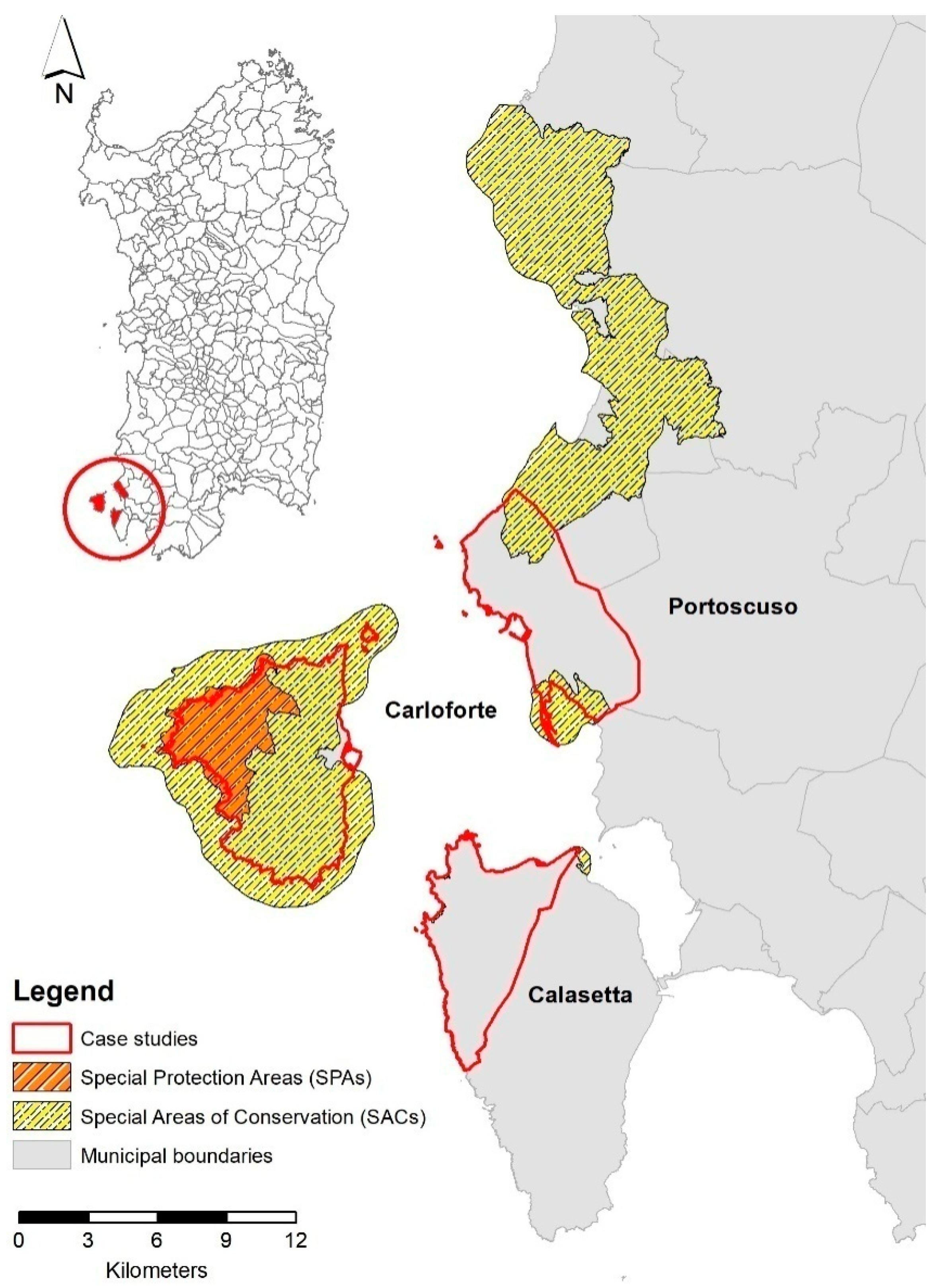
The proposed methodology is implemented in relation to three coastal municipalities—Calasetta, Carloforte, and Portoscuso—located in southwest Sardinia in the Sulcis sub-regional area (Figure 1). Calasetta, Carloforte, and Portoscuso are three small-medium sized towns with municipal areas of 31.06 km2, 51.10 km2, and 38.09 km2, respectively, and population densities of 90.86 residents/km2, 123.30 residents/km2, and 137.46 residents/km2 [16]. Moreover, Carloforte is located in a small island connected to the Sardinian island through the Port of Portovesme (in the municipality of Portoscuso) and through the Port of Calasetta. The choice of these three towns reflects the idea that they may be conceived as a homogeneous urban system where, although each municipality keeps its administrative autonomy, the coastal zone needs an integrated management approach.
Moreover, each town is characterized by the presence of a number of Natura 2000 Sites. In particular, three small-sized Special Areas of Conservation (SACs) (SAC ITB042210 “Punta Giunchera”, SAC ITB042208 “Tra Poggio La Salina e Punta Maggiore”, and SAC ITB042209 “A nord di Sa Salina”) overlap the territory of Calasetta. As regards Carloforte, its entire territory is included within the SAC ITB040027 “Isola di San Pietro”, and the Specially Protected Area (SPA) ITB043035 “Coste e Entroterra tra Punta Cannoni e Punta delle Oche—Isola di San Pietro” is located in the northwest part of the municipality. The territory of Portoscuso is partially overlapped by the SAC ITB040028 “Punta S’Aliga” and the SAC ITB040029 “Costa di Nebida”.
The documental sources of the study are the following:
- The CLUP of Calasetta, the MP of the SACs ITB042210 “Punta Giunchera,” ITB042208 “Tra Poggio La Salina e Punta Maggiore”, and ITB042209 “A nord di Sa Salina”;
- The CLUP of Carloforte, the MP of the SAC ITB040027 “Isola di San Pietro”, and the MP of the SPA ITB043035 “Coste e Entroterra tra Punta Cannoni e Punta delle Oche—Isola di San Pietro”;
- The CLUP of Portoscuso, the MP of the SAC ITB040028 “Punta S’Aliga”, and the MP of the SAC ITB040029 “Costa di Nebida”.
3. Results
The proposed methodology and its implementation in relation to the CLUPs of the three towns of Sulcis identify coastal planning processes that integrate strategies at different scales, such as the local context, represented by the local municipalities that define and approve the CLUPs, and the regional and the national levels, which superintend planning policies oriented to environmental protection.
Table 2, Table 3 and Table 4 show the LFs related to the integration of CLUPs and the MPs related to the municipalities of Calasetta, Carloforte, and Portoscuso, respectively. In particular, taking account of the specific goals and contents of the MPs, each table focuses on sustainability-oriented objectives that account for protection of plants, animals, and biodiversity. The analyzed plans are consistent with each other in terms of objectives and themes. The three CLUPs address the following specific themes: (i) relations between beach services and coastal ecosystems (T_1); (ii) protection of coastal ecosystems (T_2); and (iii) accessibility to the coastal zones (T_3). For instance, in the case of Calasetta, the CLUP’s goals are oriented towards the relations between beach services and coastal ecosystems, paying particular attention to ecosystem protection, the CLUP of Carloforte focuses on the relations between beach services and coastal ecosystem, considering accessibility as the core issue, and the CLUP of Portoscuso prioritizes ecosystem protection and accessibility. This is not surprising since: (i) the Carloforte’s municipal land coincides with the SAC “Isola di San Pietro” and, that being so, each projected spatial transformation has to pass an Appropriate Assessment which, under the provisions of the Habitats Directive, is mandatory to evaluate if (and to what extent) it may possibly generate negative impacts on the SAC [17]; (ii) Portoscuso is characterized by the presence of an important industrial site featured by non-ferrous metals manufacturing plants and, as a consequence, the CLUP’s objectives focus on protection of coastal ecosystems.
In general, despite the apparent consistency between the CLUPs’ and the MPs’ specific objectives in terms of sustainability-oriented goals, the actions planned in the CLUPs may conflict with the MPs.
As regards the municipality of Calasetta (Table 2), the main potential conflicts concern the coastal ecosystems conceived as environmental assets that need protection and as sources of economic development based on tourism and recreational activities. Indeed, the CLUP aims at defining alternative planning options to marine and coastal tourism (Goal Cal_CLUP_2) and at preventing coastal erosion processes and degradation (Goal Cal_CLUP_3). On the other hand, CLUP’s spatial transformations are oriented towards the development of coastal and marine tourist activities and towards making beaches more attractive for local and external visitors (Actions Cal_CLUP_A_2, Cal_CLUP_A_3, Cal_CLUP_A_4, Cal_CLUP_A_5, Cal_CLUP_A_6, Cal_CLUP_A_7, and Cal_CLUP_A_8). Moreover, the MP’s objectives aim at discouraging tourism (Goal Cal_MP_3), at mitigating negative impacts on the natural status of dunes (Goal Cal_MP_4), and at reducing the impacts generated by anthropic activities, animals, and infrastructure on habitats and species (Goal Cal_MP_1).
Carloforte (Table 3) shows two inconsistencies. First, the protection of marine waters (Goal Car_MP_1) and of the brown turtle Caretta caretta, a species of community interest (Goal Car_MP_9), contrasts with the authorization released to small boat charters (Action Car_CLUP_A_1). Generally, small boats do not require licenses or certified skills. As a consequence, no specific technical knowledge is needed, which relates to marine ecosystems such as seabed, particular habitats such as Posidonia oceanica, or protected species such as Caretta caretta. The second inconsistency regards the accessibility of the beaches through the installation of boardwalks (Action Car_CLUP_A_3) and the location of parking sites in proximity of protected habitats and plants (Action Car_CLUP_A_4) that may generate potential conflicts in terms of conservation of dunal habitats (Goal Car_MP_3) and of arborescent matorral, thickets, and phrygana habitats (Goal Car_MP_5).
Portoscuso (Table 4) shows the same inconsistencies as Carloforte. In fact, the realization of new pedestrian and vehicular paths (Action Por_CLUP_A_2) is likely to generate negative impacts on habitat and species (Goal Por_MP_12) as regards future expansions and conservation status (Goal Por_MP_6). Under this perspective, the construction of pedestrian and vehicular paths may entail an increase in fragmentation of habitats that implies a loss of biodiversity. The second inconsistency concerns the installation of two floating docks for leisure fishing and nautical tourism (Action Por_CLUP_A_1) and: (i) the measures that aim at protecting habitats and species (Goal Por_MP_3); and (ii) the mitigation of degradation processes of habitats and species, both in quantitative and qualitative terms (Goal Por_MP_8). The presence of floating docks may possibly increase the number of boats and, as a consequence, the negative impacts on habitats and species. Moreover, floating docks are sometimes anchored to the seabed through concrete blocks that may damage the seabed and the marine species thereof.
The quantitative relevance of the potential conflicts between the CLUPs’ actions and the MPs’ objectives is identified by an overlay area that corresponds to around 10% of the SAC ITB040027 “Isola di San Pietro” located in the municipality of Carloforte [19] and to around 30% of the SAC ITB040028 “Punta S’Aliga” located in the municipality of Portoscuso [20]. Table 5 shows the habitat areas and the corresponding percentage shares as regards the overlay areas. In the case of the SAC ITB040028 “Punta S’Aliga” in the municipality of Portoscuso, a share of about 86% of the overlay area is covered by habitats classified under the provisions of the Habitats Directive (from now on indicated as “classified habitats”). The largest habitat is “Posidonia beds” that covers 73.81% of the overlay area. In relation to the SAC ITB040027 “Isola di San Pietro” in the municipality of Carloforte, the overlay area covered by classified habitats is around 41%. The largest overlay area shows the simultaneous presence of two classified habitats (“vegetated sea cliffs of the Mediterranean coasts with endemic Limonium spp.” and “low formations of Euphorbia close to cliffs”) that cover 18.31% of the overlay area.
Moreover, as explained in the examples below, the conflicts between CLUPs’ actions and MPs’ objectives are not only related to the overlay areas but also to impacts on classified habitats generated by CLUPs’ actions that take place outside the overlay areas.
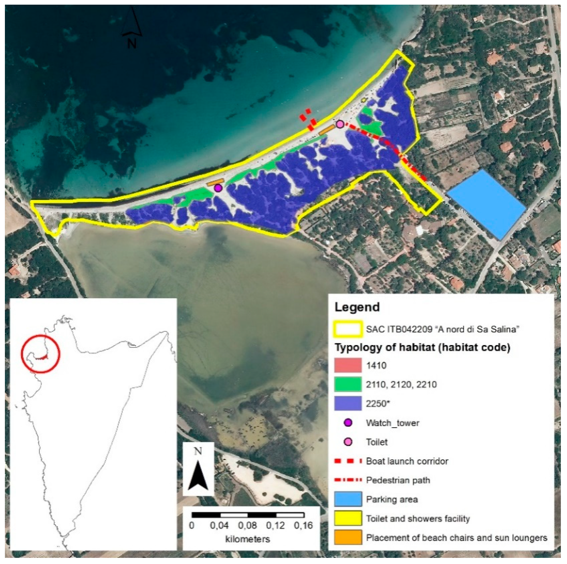
In the case of Calasetta, beach chairs, sun loungers, toilets, and shower facilities planned by the CLUP in order to make the beaches more attractive are likely to generate negative impacts on classified coastal habitats by increasing the number of tourists, even though they are located outside the MP’s area. The overlay area just concerns the access to the beaches through pedestrian paths, as shown in Figure 2.
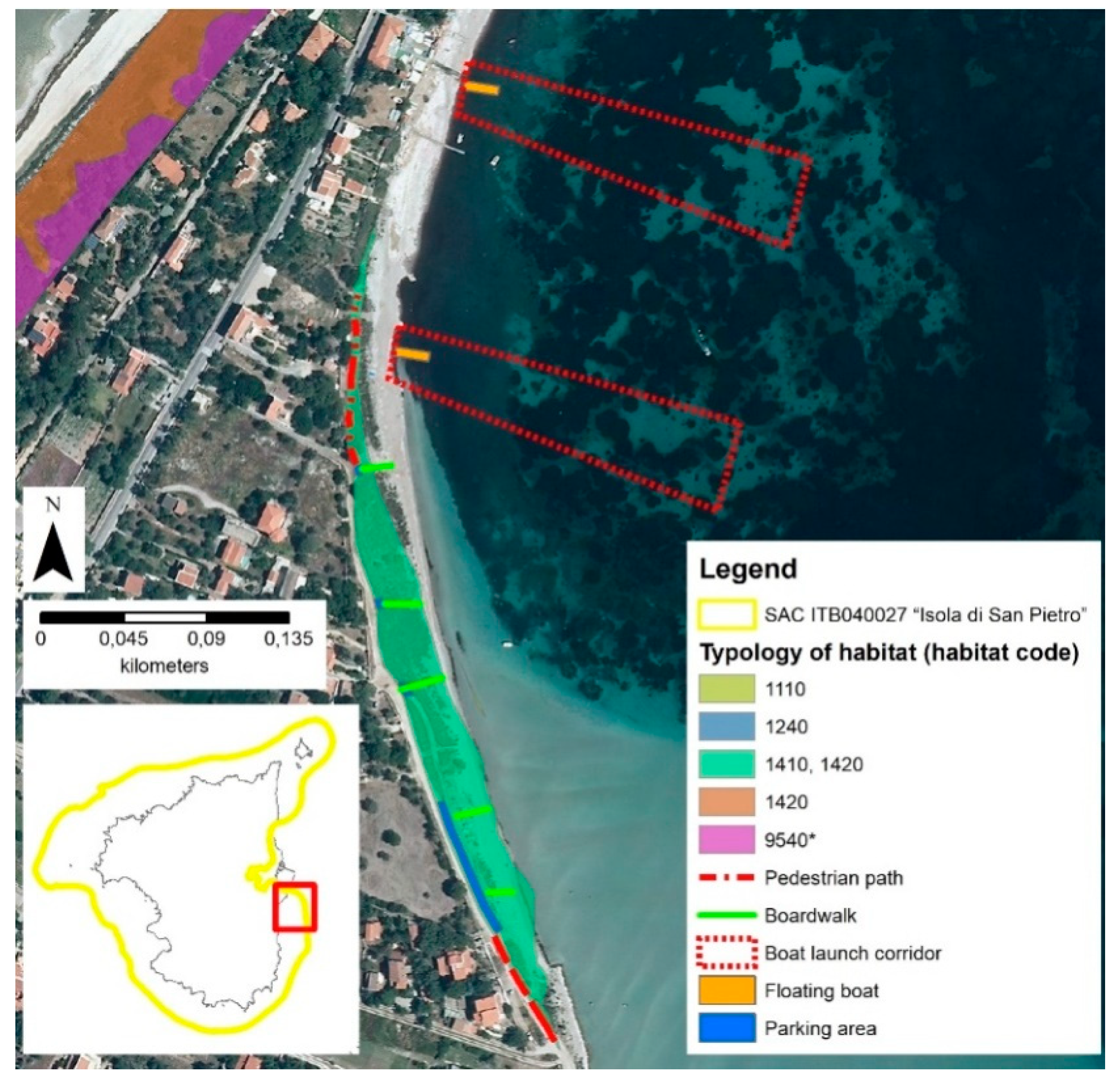
Similarly, in the case of Carloforte, some conflicts are not specifically related to overlay areas. For instance, the conflict of Goals Car_MP_1 and Car_MP_9 with respect to Action Car_CLUP_A_1 is due to the potential negative impacts of small boat charters on classified marine habitats, which are not related to overlay areas. Furthermore, the conflicts of Action Car_CLUP_A_3 with respect to Goal Car_MP_3 and of Action Car_CLUP_A_4 with respect to Goal Car_MP_5 are due to the newly-planned beach accesses, whose negative impacts are not related to the very small size of the overlay areas. As shown in Figure 3, the total parking area of 490 square meters (the blue area within the green coastal patch) is about 5% of the area covered by habitats 1410 and 1420 (“Mediterranean salt meadows” and “Mediterranean and thermo-Atlantic halophilous scrubs”) that are in the green coastal patch. The increase in parking areas, vehicles, and tourist presences will eventually generate relevant negative impacts on classified coastal and marine habitats that are not connected to their areal size.
As regards the municipality of Portoscuso, no overlay area is detected with reference to the CLUP’s actions and the classified habitat areas. For example, as shown in Figure 4, although the newly-planned floating docks for leisure fishing and nautical tourism (Action Por_CLUP_A_1) do not overlay any habitat area, the presence of these facilities may very possibly generate negative impacts on classified habitats and species.
4. Discussion and Conclusions
The three LFs show potential negative impacts that may be generated by the actions planned by the CLUPs. The assessment of the three cases concerning the towns of Calasetta, Carloforte, and Portoscuso highlights that the CLUPs and the MPs are characterized by a marked inconsistency since they were defined and approved through autonomous planning approaches, which were implemented by different public administrations, namely, the region as regards the MPs and the municipalities with reference to the CLUPs. Moreover, the two types of plan have different scopes since MPs state conservation measures related to Natura 2000 Sites, that is, protection of habitats and species, whereas CLUPs concern sustainable land-use approaches to coastal zone management.
Under this perspective, this study proposes and implements (as regards the coastal zones of the three municipalities of the Sulcis area) a methodology that aims at achieving consistency between the CLUPs and the MPs on the basis of the definition of the LFs.
The proposed detailed comparative assessment of the MPs and the CLUPs related to the three Sulcis municipalities implies a relevant contribution in this direction and, moreover, it leads the question of protection and improvement of species and habitats beyond the limits of sectoral plans regarding the Natura 2000 Sites. The proposed LF makes the issue of protection of habitats and species a central question in spatial policies as regards the coastal zones of the municipal areas regulated by the CLUPs. Supporting ecosystem services (ESs) provided by habitats and species [21] are the founding elements of the LFs since sustainability objectives, which are the LF’s backbone, are largely based on the need to protect Natura 2000 Sites and to extend this conservationist approach outside the boundaries of the Natura 2000 Network [15].
Consistency of CLUPs and MPs entails overcoming the conflicts generated by different and sometimes conflicting objectives, which are mirrored by the planned land uses and spatial policies. These are the conflicts between the conservation of supporting ecosystems (habitats and species) and the increase in the supply of tourism-related ESs concerning the increase in the attractiveness of the coastal areas for tourists and local visitors, which is the main reason for the definition and the approval of CLUPs [22].
A central issue to be addressed and discussed as regards this study is how its implications can be generalized in order to resolve or at least mitigate the conflicts arising from the inconsistencies between the different priorities of coastal land use plans, defined and implemented by the local administrations, and of conservation measures established on Natura 2000 Sites, defined by the national governmental administrations of the EU countries under the provisions of the Habitats and Birds Directives.
From this point of view, it is evident that the quantitative spatial relevance of the conflicts is an important question since, if different priorities between local plans and Natural 2000 Sites are identified in large parts of the coastal areas, the effectiveness of public spatial policies will be heavily dependent on how these conflicts are addressed. This is the case of the municipalities of Carloforte and Portoscuso, where the conflicting areas cover about 10% of the SAC ITB040027 “Isola di San Pietro” in the municipality of Carloforte and about 30% of the SAC ITB040028 “Punta S’Aliga” in the municipality of Portoscuso. On the other hand, potential conflicts are not only ascribable to the overlay areas but also to the impacts of CLUPs’ actions, though they are irrelevant with reference to their areal size, which may generate relevant negative effects on classified habitats. Consistent with what is observed in the planning processes of several coastal areas of the EU [23,24,25], the conflicts are essentially due to the fact that coastal land use plans aim at making coastal areas easily accessible for car, bike, and pedestrian traffic and attractive in terms of beach tourist services (see the potentially unfavorable CLUP’s actions reported in the last column of Table 2), whereas the conservation measures related to Natura 2000 Sites aim at preventing negative impacts on coastal and marine habitats and species, which are likely to be generated by the implementation of the provisions of local coastal plans.
This premise entails that the nature of the conflicts and their relevant spatial size make the case of the Sulcis municipalities an important and significant paragon to address the general question of resolving the conflicts between local plans and conservation measures established by national plans. This is even more the case since the conservation measures of the Natura 2000 Sites are based on the Standard Data Form (SDF) [26] established by the EU Decision taken on 11 July 2011. That being so, management and conservation measures derived from the SDFs are consistent with each other as regards all the countries of the Union. As a consequence, the implications coming from the outcomes of this study can be taken as general recommendations related to the solution of conflicts as regards all the countries of the EU and all the spatial contexts where ecological networks are established whose institutional and technical frameworks are similar to the Natura 2000 Network’s.
Under this perspective, an outstanding implication can be derived by combining the results presented in the previous section with the conclusions of an important study of Kovács et al. on identifying and resolving conflicts related to trade-offs between protection of nature and natural resources and expectations regarding local development based on the exploitation of the provisions generated by the environment and its services [27]. The main point of the Kovács et al.’s study [27] is that the scale issues play a fundamental role in generating the conflicts. As a consequence, the solution of the conflicts has to be identified by dealing with the scale of the planning process. In Kovács et al.’s study [27], the scale issue was related to the fact that conservation measures related to three Natura 2000 Sites established by the Hungarian government in the Great Hungarian Plain were in conflict with the traditional agricultural land uses defined by the local rural plans. The argument of Kovács et al. [27] is that a fine-tuning of the spatial and the temporal layout of the conservation measures based on close cooperation between the national and the local authorities would have been the most effective approach to mitigating, if not avoiding, the negative impact of the Natura 2000 Sites-related spatial policies on the local economy mainly based on small farmers’ production. The scale issue is quite similar with respect to the case of the Sulcis municipalities and of the other EU Natura 2000 Sites-related spatial contexts.
Thus, the integration of Kovács et al.’s article [27] and the findings of this study entails that a unique planning authority should be established, which should plan and implement both conservation measures related to the Natura 2000 Sites and regulations concerning coastal land uses. Representatives of the national Ministry of the Environment and of the local governments should participate in political and technical boards of this authority so as to make all priorities and expectations equitably visible and expressed in a decision-making process, which should result in a unique planning and regulatory instrument. Moreover, an important task of the authority should be the development of appropriate awareness-raising campaigns aimed at increasing the attitude of the local communities towards the relevant role of conservation of nature and natural resources in promoting and catalyzing the local social and economic development so as to bridge the obstacles generated by the under-evaluation of the temporal layout problems related to planning policies’ implementation [27,28].
At present, a very heterogeneous situation characterizes the Italian approach to the definition and the implementation of conservation measures and MPs of the Natura 2000 Sites. While conservation measures are always approved by the national Ministry of the Environment, the definition of the measures can be either part of the MPs of the Natura 2000 Sites or established through a planning process not related to an MP. The definition of conservation measures and MPs can be under the responsibility of a number of public bodies, such as municipalities, regional administrations, regional parks and natural reserves, and regional environmental protection agencies. Public participation and public awareness-raising processes are not mandatory and are not frequently implemented. Finally, only three out of 21 regional administrations implement conservation measures and MPs into their spatial planning regulations [29]. The Italian situation, which is quite consistent with what occurs in the other EU countries, gives support to the implication discussed above, which integrates the findings of this study into Kovács et al.’s argument. This implication entails the need to establish a new authority responsible for the definition and the implementation of spatial policies that implement MPs and conservation measures into local planning regulations. In order to be effective and operational, the establishment of the new authority should be based on the provisions of a new regulation or directive approved by the European Parliament and the Council.
There are three promising future directions coming from this study. First, the restrictions on land uses imposed by the MPs and evidenced in the last column of the LFs of the three towns of the Sulcis area, which are likely to generate a decrease in the attractiveness of the coastal areas for tourists and local visitors, entail the need to assess the trade-off between the decreased provision of tourism-related ESs and supporting ESs provided by habitats and species [15]. Several studies in the current literature deal with the economic evaluation of tourism-related ESs, which are based on estimates of the market values of these services [30,31,32,33].
Furthermore, assessments of the economic value made available from species and habitats protected according to the Habitats and Birds Directives are rare, and, that being so, there is plenty of room for future research on the evaluation of the economic value of supporting ESs. The Millennium Ecosystem Assessment [21] and Busch et al. [34] estimate the economic value of habitats- and species-related ESs in terms of indirect or direct willingness to pay on the basis of the public-good nature, which implies the impossibility of identifying the value of these supporting ESs through their market price, which cannot be observed since they are non-excludable and non-rivalrous [15]. Estimates implemented on the basis of the hedonic approach in terms of direct (observed) willingness to pay [35,36,37] or of the contingent valuation methodologies in terms of indirect willingness to pay [34,38,39] are solid references for the assessment of the economic value of supporting ESs.
Research aimed at identifying the value of tourism-related and supporting ESs will make adequate estimates available that will make it possible to implement effective decision-making processes concerning the optimal mix between provisions of different types of ESs and, as a consequence, between CLUPs’ and MPs’ planning policies and related conflicting actions.
Secondly, the following relevant question should be carefully taken into account as regards the trade-offs between tourism-related and supporting ESs. The assessment of the economic value of the trade-offs between recreational and supporting ESs should entail the comparison between the additional demand for recreational ESs, which would eventually be unsatisfied as a consequence of the implementation of conservation measures aimed at preserving habitats and species and the increase in the demand for supporting ESs satisfied through these measures, since a balance of the gained and the lost economic value can only be associated with truly demanded ESs. This question is treated by Bastian et al. [40] from a theoretical standpoint on the basis of ecosystem potentials, properties, and services of ESs (EPPS). The integration of Bastian et al.’s findings [40] and the outcomes of this study could be very helpful in order to deal with the issue of the demand side as regards the trade-off between tourism-related and supporting ESs.
Thirdly, following Bastian [41] among many, it has to be highlighted that the exploration of trade-offs concerning the supply of other ESs—namely, provisioning, regulating, and cultural ESs—is quite promising as a future research direction.
Finally, addressing the conflicts that may arise between planning measures and actions just on the basis of the spatial zoning regulations of CLUPs and MPs can possibly result in scientifically-weak implications. An important complementary spatial analysis would entail the assessment of losses and gains in the supply of ESs on the basis of land cover taxonomies made available by CORINE Land Cover-based detailed datasets [42], such as the Copernicus Project Database [43]. In future research, the trade-offs between planning policies and actions identified through differences in the provision of categories of ESs should be qualified in terms of losses and gains in the supply of land uses rather than of land covers, since the intensity of management and the production of wealth can only be identified through land uses, which CORINE-like spatial taxonomies do not capture. Another relevant issue that needs to be addressed is the relationship between planning policies and measures and the resulting visual landscape, which plays an important role in shaping the attractiveness of spatial contexts [44,45,46,47].
Author Contributions
Funding
This research received no external funding.
Acknowledgments
The study was implemented within the Research Program “TSulki: Tourism and Sustainability in the Sulcis sub-regional area”, funded by the Autonomous Region of Sardinia for the period 2018–2019, under the provisions of the Call for the presentation of “Projects related to fundamental or basic research for the implementation of interventions in relation to the research context of the Sulcis Plan” of the year 2015, implemented at the Department of Civil and Environmental Engineering and Architecture (DICAAR) of the University of Cagliari, Italy.
Conflicts of Interest
The authors declare no conflict of interest. The supporting sponsor had no role in the design of the study; in the collection, analyses, or interpretation of data; in the writing of the manuscript, and in the decision to publish the results.
References and Notes
- Saffache, P.; Angelelli, P. Integrated coastal zone management in small islands: A comparative outline of some islands of the Lesser Antilles. J. Integr. Coast. Zone Manag. 2010, 10, 255–279. [Google Scholar] [CrossRef]
- Billé, R. Integrated coastal zone management: Four entrenched illusions. Surv. Perspect. Integr. Environ. Soc. 2008, 1, 12. [Google Scholar] [CrossRef]
- The Text of the ICZM Protocol. Available online: https://eur-lex.europa.eu/legal-content/EN/TXT/PDF/?uri=CELEX:22009A0204(01)&from=EN (accessed on 10 May 2019).
- Soriani, S.; Buono, F.; Camuffo, M. Problems and pitfalls in ICZM implementation: Lessons from some selected Mediterranean and Black Sea cases. J. Integr. Coast. Zone Manag. 2015, 18, S1-002. [Google Scholar] [CrossRef]
- Burbridge, B.; Humphrey, S. Introduction to the special issue on the European demonstration program on integrated coastal zone management. Coast. Manag. 2003, 31, 121–126. [Google Scholar] [CrossRef]
- Suárez de Vivero, J.L.; Rodríguez Mateos, J.C. Coastal crisis: The failure of coastal management in the Spanish Mediterranean Region. Coast. Manag. 2007, 33, 197–214. [Google Scholar] [CrossRef]
- Shipman, B.; Stojanovic, T. Facts, fictions, and failures of integrated coastal zone management in Europe. Coast. Manag. 2007, 35, 375–398. [Google Scholar] [CrossRef]
- Rochette, J.; Billé, R. (Eds.) Analysis of the Mediterranean ICZM Protocol: At the Crossroads Between the Rationality of Provisions and the Logic of Negotiations. Institute for Sustainable Development and International Relations (IDDRI), 2010. Available online: http://www.cirspe.it/gizc/Pubblicazioni/Pubblicazioni%202/4-%20ICZM_Med_IDDRI.pdf (accessed on 10 May 2019).
- Leone, F.; Zoppi, C. The delicate relationship between capitalization and impoverishment of cultural and landscape resources in the context of Strategic Environmental Assessment of municipal master plans: A case study concerning Tertenia, Sardinia. In Atti della XVIII Conferenza Nazionale SIU. Italia ’45-’45. Radici, Condizioni, Prospettive. Venezia, 11–13 Giugno 2015 [Proceedings of the XVIII National Conference of SIU [The Italian Society of Urban and Regional Planners]. Italy ’45-’45. Roots, Conditions, Perspectives. Venice, Italy, 11–13 June 2015]; Various Authors, Ed.; Planum Publisher: Rome-Milan, Italy, 2015; pp. 1458–1467. [Google Scholar]
- UNEP (United Nations Environment Programme); MAP (Mediterranean Action Plan). Priority Actions Program. Action Plan. for the Implementation of the ICZM Protocol for the Mediterranean—2012–2019. Draft (September 2011). Available online: https://www.pap-thecoastcentre.org/razno/Action%20Plan%20clear%20version%2013%20Sept%2011%20BS-2.pdf (accessed on 10 May 2019).
- Harvey, N. Strategic environmental assessment in coastal zones, especially Australia’s. Impact Assess. Proj. Apprais. 2000, 18, 225–232. [Google Scholar] [CrossRef]
- Partidário, M.R.; Vicente, G.; Lobos, V. Strategic environmental assessment of the national strategy for integrated coastal zone management in Portugal. J. Coast. Res. 2009, 2, 1271–1275. [Google Scholar]
- Natura 2000 sites includes three typologies of areas: Special protection areas (SPAs), established under EU Directive 2009/147/EC (the Birds Directive), and Sites of community importance (SCIs) and Special areas of conservation (SACs), established under EU Directive 92/43/EEC (the Habitats Directive).
- Leone, F.; Zoppi, C. Ecosystem services as external drivers in the Strategic environmental assessment of management plans of the sites of the Natura 2000 network. Urban. Inf. 2015, 42, 34–38. [Google Scholar]
- Leone, F.; Zoppi, C. Conservation measures and loss of ecosystem services: A study concerning the Sardinian Natura 2000 Network. Sustainability 2016, 8, 1061. [Google Scholar] [CrossRef]
- Istat [The Italian National Institute of Statistics] Superfici delle Unità Amministrative. Superficie di Comuni, Province e Regioni Italiane al 9 Ottobre 2011 [Surfaces of Administrative Units. Surfaces of Italian Local Municipalities, Provinces and Regions on 9 October 2011]. 2011. Available online: https://www.istat.it/it/archivio/156224 (accessed on 10 May 2019).
- “Any plan or project not directly connected with or necessary to the management of the site but likely to have a significant effect thereon, either individually or in combination with other plans or projects, shall be subject to appropriate assessment of its implications for the site in view of the site’s conservation objectives […] [T]he competent national authorities shall agree to the plan or project only after having ascertained that it will not adversely affect the integrity of the site concerned and, if appropriate, after having obtained the opinion of the general public.” (Habitats Directive, art. 6, paragraph 3).
- The information sources concerning the items of the five columns of Table 2, Table 3 and Table 4 are the following. (i) “Sustainability-oriented objectives,” “Themes.” “CLUP’s specific objectives” and “Potentially unfavorable CLUP’s actions.” Calasetta: CLUP of Calasetta. Available online: http://albopretorio.comune.it/calasetta/AmministrazioneTrasparente/Pianificazionegovernoterritorio.aspx (accessed on 10 May 2019). Carloforte: CLUP of Carloforte. Available online: http://ww2.gazzettaamministrativa.it/opencms/opencms/_gazzetta_amministrativa/amministrazione_trasparente/_sardegna/_carloforte/190_pia_gov_ter/2015/Documenti_1424947761165/ (accessed on 10 May 2019). Portoscuso: CLUP of Portoscuso. Available online: https://drive.google.com/drive/folders/1LVQLSZlgYVgpdNyoHt-KknlYOOzzDjQi (accessed on 10 May 2019). (ii) “Sustainability-oriented objectives” and “MP’s specific objectives.” Calasetta: The MP of the SACs ITB042210 “Punta Giunchera,” ITB042208 “Tra Poggio La Salina e Punta Maggiore” and ITB042209 “A nord di Sa Salina.” Available online: http://www.sardegnaambiente.it/documenti/18_183_20160421121516.zip. Carloforte: The MP of the SAC ITB040027 “Isola di San Pietro” (Available online: http://www.sardegnaambiente.it/documenti/18_183_20170830162930.zip, accessed on 10 May 2019), and the MP of the SPA ITB043035 “Coste e Entroterra tra Punta Cannoni e Punta delle Oche—Isola di San Pietro” (Available online: http://www.sardegnaambiente.it/documenti/18_183_20170830163754.zip, accessed on 10 May 2019). Portoscuso: The MP of the SAC ITB040028 “Punta S’Aliga” (Available online: http://www.sardegnaambiente.it/documenti/18_183_20160418181506.zip, accessed on 10 May 2019), and the MP of the SAC ITB040029 “Costa di Nebida” (Available online: http://www.sardegnaambiente.it/documenti/18_183_20160419103004.zip, accessed on 10 May 2019). The “Sustainability-oriented objectives” are defined through the integration of the CLUPs’ and the MPs’ sustainability objectives, which are substantially consistent with each other.
- The SPA ITB043035 “Coste e Entroterra tra Punta Cannoni e Punta delle Oche—Isola di San Pietro” is totally included within the SAC ITB040027 “Isola di San Pietro”. That being so, the calculation of the overlay area is redundant.
- In the case of the SAC ITB040029 “Costa di Nebida,” located in the municipality of Portoscuso, and of all the SACs located in the municipality of Calasetta is not possible to calculate the the overlay share due to lack of reliable geo-referenced data.
- Millennium Ecosystem Assessment. Ecosystems and Human Well-Being: A Framework for Assessment; Island Press: Washington, DC, USA, 2003; ISBN 1559634030. [Google Scholar]
- Lai, S.; Zoppi, C. The influence of Natura 2000 Sites on land-taking processes at the regional level: An empirical analysis concerning Sardinia (Italy). Sustainability 2017, 9, 259. [Google Scholar] [CrossRef]
- Jones, P.J.; Lieberknecht, L.M.; Qiu, W. Marine spatial planning in reality: Introduction to case studies and discussion of findings. Mar. Policy 2016, 71, 256–264. [Google Scholar] [CrossRef]
- Piwowarczyk, J.; Wróbel, B. Determinants of legitimate governance of marine Natura 2000 Sites in a post-transition European Union country: A case study of Puck Bay, Poland. Mar. Policy 2016, 71, 310–317. [Google Scholar] [CrossRef]
- Fraschetti, S.; Pipitone, C.; Mazaris, A.D.; Rilov, G.; Badalamenti, F.; Bevilacqua, S.; Claudet, I.; Carić, H.; Dahl, K.; D’Anna, G.; et al. Light and shade in marine conservation across European and contiguous seas. Front. Mar. Sci. 2018, 5, 420. [Google Scholar] [CrossRef]
- The Standard Data Forms of all Natura 2000 Sites. Available online: http://natura2000.eea.europa.eu/ (accessed on 10 May 2019).
- Kovács, E.; Kelemen, K.; Kalóczkai, A.; Margóczi, K.; Pataki, G.; Gébert, J.; Málovics, G.; Balázs, B.; Roboz, A.; Krasznai Kovács, E.; et al. Understanding the links between ecosystem service trade-offs and conflicts in protected areas. Ecosyst. Serv. 2015, 12, 117–127. [Google Scholar] [CrossRef] [Green Version]
- As regards the three Sulcis municipalities, at present, there is no evidence of any attempt to deal with the spatial scale issue, that is to develop a virtuous cooperative planning process involving the national and local governments in order to bridge the gap between national and local planning processes, and related spatial regulations. Moreover, there is no evidence of any attempt to consider the temporal scale, since no time was dedicated by the national authorities to increase the local authorities’ and communities’ awareness concerning the importanve, and the implied value-added, for the local economies of protection and improvement of the quality of nature and natural resources.
- The information presented in this paragraph is drawn from the analytical assessment of the process of definition and implementation of MPs and conservation measures concerning the Italian Natura 2000 Sites proposed in: Lai, S. Tra tecnocrazia e inclusione nella pianificazione per la tutela delle risorse naturali: un’analisi dei processi nei siti Natura 2000 in Italia [Between technocracy and inclusion in spatial planning for conservation of natural resources: An analysis of processes related to Natura 2000 sites in Italy]. In Ricerca in Vetrina 2018. Ricerca è democrazia. Il Ruolo dell’Attività Scientifica nella Costruzione di un Futuro Equo e Solidale [Research in a Shop Window. Research is Democracy. The Role of Scientific Activity in the Building Process of a Fair and Equitable Future]; Saiu, V., Mastinu, M., Angius, F., Leccis, F., Mei, G., Mura, E., Lai, L., Mais, S., Pinna, A., Cabras, R., et al., Eds.; FrancoAngeli: Milan, Italy, 2018; pp. 124–135. ISBN 9788891783806. [Google Scholar]
- Campagne, C.S.; Salles, J.M.; Boissery, P.; Deter, J. The seagrass Posidonia oceanica: Ecosystem services identification and economic evaluation of goods and benefits. Mar. Pollut. Bull. 2015, 97, 391–400. [Google Scholar] [CrossRef] [PubMed]
- Barbier, E.B.; Hacker, S.D.; Kennedy, C.; Koch, E.W.; Stier, A.C.; Silliman, B.R. The value of estuarine and coastal ecosystem services. Ecol. Monogr. 2011, 81, 169–193. [Google Scholar] [CrossRef]
- Zander, K.K.; Straton, A. An economic assessment of the value of tropical river ecosystem services: Heterogeneous preferences among Aboriginal and non-Aboriginal Australians. Ecol. Econ. 2010, 69, 2417–2426. [Google Scholar] [CrossRef]
- Lange, G.M.; Jiddawi, N. Economic value of marine ecosystem services in Zanzibar: Implications for marine conservation and sustainable development. Ocean Coast. Manag. 2009, 52, 521–532. [Google Scholar] [CrossRef]
- Busch, M.; La Notte, A.; Laporte, V.; Erhard, M. Potentials of quantitative and qualitative approaches to assessing ecosystem services. Ecol. Indic. 2012, 21, 89–103. [Google Scholar] [CrossRef]
- Zoppi, C.; Argiolas, M.; Lai, S. Factors influencing the value of houses: Estimates for the city of Cagliari, Italy. Land Use Policy 2015, 42, 367–380. [Google Scholar] [CrossRef]
- Cheshire, P.; Sheppard, S. On the price of land and the value of amenities. Economica 1995, 62, 247–267. [Google Scholar] [CrossRef]
- Palmquist, R.B. Estimating the demand for the characteristic of housing. Rev. Econ. Stat. 1984, 66, 394–404. [Google Scholar] [CrossRef]
- Zoppi, C.; Lai, S. Assessment of the Regional Landscape Plan of Sardinia (Italy): A participatory-action-research case study type. Land Use Policy 2010, 27, 690–705. [Google Scholar] [CrossRef]
- León, C.J. El metodo dicotomico de valoracion contingente: Una aplicacion a los espacios naturales en Gran Canaria [The dichotomous method of Contingent Valuation: An application to the natural resources of Great Canaria]. Investig. Econ. 1995, 19, 83–106. [Google Scholar]
- Bastian, O.; Haaseb, D.; Grunewald, K. Ecosystem properties, potentials and services—The EPPS conceptual framework and an urban application example. Ecol. Indic. 2012, 21, 7–16. [Google Scholar] [CrossRef]
- Bastian, O. The role of biodiversity in supporting ecosystem services in Natura 2000 Sites. Ecol. Indic. 2013, 24, 12–22. [Google Scholar] [CrossRef]
- European Environment Agency. CORINE Land Cover. 2013. Available online: http://www.eea.europa.eu/publications/COR0-landcover (accessed on 10 May 2019).
- Copernicus is the European Union’s Earth Observation Programme, Looking at our Planet and Its Environment for the Ultimate Benefit of All European Citizens. It Offers Information Services Based on Satellite Earth Observation and in situ (non-space) data (text drawn from): The Copernicus Project Database Europe’s eyes on Earth. Available online: https://www.copernicus.eu/en/about-copernicus; https://www.copernicus.eu/en/research/project-database (accessed on 10 May 2019).
- Heagney, E.C.; Rose, J.M.; Ardeshiri, A.; Kovac, M. Optimising recreation services from protected areas—Understanding the role of natural values, built infrastructure and contextual factors. Ecosyst. Serv. 2018, 31, 358–370. [Google Scholar] [CrossRef]
- Lai, S.; Leone, F.; Zoppi, C. Implementing green infrastructures beyond protected areas. Sustainability 2018, 10, 3544. [Google Scholar] [CrossRef]
- Amoako-Tuffour, J.; Martinez-Espineira, R. Leisure and the net opportunity cost of travel time in recreation demand analysis: An application to Gros Morne national park. J. Appl. Econom. 2012, 15, 25–49. [Google Scholar] [CrossRef]
- Font, A.R. Mass tourism and the demand for protected natural areas: A travel cost approach. J. Environ. Econom. Manag. 2000, 39, 97–116. [Google Scholar] [CrossRef]
Figure 1.
The study area.

Figure 2.
Overlay area related to the CLUP’s actions and the SAC ITB042209 “A nord di Sa Salina” in the municipality of Calasetta.
Figure 2.
Overlay area related to the CLUP’s actions and the SAC ITB042209 “A nord di Sa Salina” in the municipality of Calasetta.

Figure 3.
Overlay area related to the CLUP’s actions and the SAC ITB040027 “Isola di San Pietro” in the municipality of Carloforte.
Figure 3.
Overlay area related to the CLUP’s actions and the SAC ITB040027 “Isola di San Pietro” in the municipality of Carloforte.

Figure 4.
Overlay area between CLUP’s actions and the SAC ITB040028 “Punta S’Aliga” in the municipality of Portoscuso.
Figure 4.
Overlay area between CLUP’s actions and the SAC ITB040028 “Punta S’Aliga” in the municipality of Portoscuso.


Table 1.
The structure of the logical framework (LF).
| Sustainability-Oriented Objectives | Themes | CLUP’s Specific Objectives | MP’s Specific Objectives | Potentially Unfavorable CLUP’s Actions |
|---|---|---|---|---|
| Sustainability-oriented objectives 1 | Theme 1 | Specific objective 1 of CLUP | Specific objective 1 of MP | Action 1 Action m |
| Specific objective k of MP | Action 1 Action m | |||
| Specific objective j of CLUP | Specific objective 1 of MP | Action 1 Action m | ||
| Specific objective k of MP | Action 1 Action m | |||
| Theme h | Specific objective 1 of CLUP | Specific objective 1 of MP | Action 1 Action m | |
| Specific objective k of MP | Action 1 Action m | |||
| Specific objective j of CLUP | Specific objective 1 of MP | Action 1 Action m | ||
| Specific objective k of MP | Action 1 Action m |
CLUP: coastal land use plans; MP: management plans.
Table 2.
LF of the integration of the CLUP and of the MP concerning the town of Calasetta [18].
Table 2.
LF of the integration of the CLUP and of the MP concerning the town of Calasetta [18].
| Sustainability-Oriented Objectives | Themes | CLUP’s Specific Objectives | MP’s Specific Objectives | Potentially Unfavorable CLUP’s Actions |
|---|---|---|---|---|
| Cal_SOO_1 Conservation and protection of biodiversity and coastal ecosystems | T_1 Relations between beach services and coastal ecosystems | Cal_CLUP_1 Planning beach services in relation to natural, rural, and urban contexts | Cal_MP_1 Reduction or elimination of impacts induced by anthropic activities, animals and infrastructure on habitats and species | Cal_CLUP_A_1 Authorization for pet-care services |
| Cal_CLUP_A_2 Installation of pedestrian boardwalks | ||||
| Cal_MP_2 Restoration of the natural coastal morphology | ||||
| Cal_CLUP_2 Definition of naturalistic measures in relation to reefs, in order to identify possible alternatives available to marine and coastal tourism | Cal_MP_3 Mitigation of overuse of beaches, in particular during summer | Cal_CLUP_A_3 Installation of dressing rooms and small cabanas | ||
| Cal_CLUP_A_4 Placement of beach chairs and sun loungers | ||||
| Cal_CLUP_A_5 Installation of cabanas for the watchpersons | ||||
| Cal_CLUP_A_6 Installation of toilet and shower facilities | ||||
| Cal_CLUP_A_7 Installation of kiosks selling beverages and snacks | ||||
| Cal_CLUP_A_8 Installation of small stands in support of beach services and activities such as small boat charters, diving, and sailing schools | ||||
| T_2 Protection of coastal ecosystems | Cal_CLUP_3 Prevention of coastal erosion processes and degradation | Cal_MP_4 Mitigation of negative impacts on the natural status of dunes and prevention of their degradation | Cal_CLUP_A_2 Installation of pedestrian boardwalks | |
| Cal_MP_5 Mitigation of coastal erosion effects and restoration of dunal systems | ||||
| Cal_MP_6 Integration of measures aiming at removing Posidonia oceanica deposits from the beaches and at protecting coastal and marine habitats | ||||
| Cal_CLUP_4 Promotion of environmental rehabilitation | Cal_MP_1 Reduction or elimination of impacts determined by anthropic activities, animals, and infrastructure on habitats and species | Cal_CLUP_A_1 Authorization for pet-care services | ||
| Cal_MP_2 Restoration of the natural coastal morphology | ||||
| Cal_MP_4 Mitigation of damages to the natural status of dunes e prevention of their degradation | Cal_CLUP_A_2 Installation of pedestrian boardwalks | |||
| Cal_MP_7 Protection and restoration of Posidonia oceanica meadows in the mooring areas | ||||
| Cal_CLUP_5 Conservation of the salt pan | Cal_MP_6 Integration of measures aiming at removing Posidonia oceanica deposits from the beaches and at protecting coastal and marine habitats |
Table 3.
LF of the integration of the CLUP and of the MP concerning the town of Carloforte [18].
Table 3.
LF of the integration of the CLUP and of the MP concerning the town of Carloforte [18].
| Sustainability-Oriented Objectives | Themes | CLUP’s Specific Objectives | MP’s Specific Objectives | Potentially Unfavorable CLUP’s Actions |
|---|---|---|---|---|
| Car_SOO_1 Conservation and restoration of coastal ecosystems, paying particular attention to habitats and species of community interests | T_1 Relations between beach services and coastal eco-systems | Car_CLUP_1 Planning beach-related services and activities consistently with landscape and environmental protection goals | Car_MP_1 Protection of marine waters | Car_CLUP_A_1 Authorization released to small boat charters |
| Car_MP_2 Conservation of the reef habitats | Car_CLUP_A_2 Provision of the minimum service level in support of tourism in the most popular sandy and rocky beaches | |||
| Car_MP_3 Conservation of dunal habitats | ||||
| Car_MP_4 Promotion of sustainable uses of sites and related environmental resources | ||||
| Car_MP_5 Conservation of arborescent matorral, thickets, and phrygana habitats | ||||
| Car_MP_6 Conservation of important botanical species, such as Astragalus maritimus and Rouya polygama | ||||
| Car_MP_7 Protection of the most important bird species living in the Natura 2000 Sites located in Carloforte | ||||
| Car_MP_8 Protection of the local faunistic resources | ||||
| Car_MP_9 Protection of Caretta caretta, a species of community interest | Car_CLUP_A_1 Authorization released to small boat charters | |||
| T_3 Accessibility | Car_CLUP_2 Organization of an access point system and of the parking sites in order to regulate public access to beaches and coastal areas, minimizing environmental impacts | Car_MP_2 Conservation of the reef habitats | ||
| Car_MP_3 Conservation of dunal habitats | Car_CLUP_A_3 Installation of boardwalk access to beaches | |||
| Car_MP_4 Promotion of sustainable uses of sites and related environmental resources | ||||
| Car_MP_5 Conservation of arborescent matorral, thickets, and phrygana habitats | Car_CLUP_A_4 Identification of parking sites in proximity of arborescent matorral, thickets, and phrygana habitats |
Table 4.
LF of the integration of the CLUP and of the MP concerning the town of Portoscuso [18].
Table 4.
LF of the integration of the CLUP and of the MP concerning the town of Portoscuso [18].
| Sustainability-Oriented Objectives | Themes | CLUP’s Specific Objectives | MP’s Specific Objectives | Potentially Unfavorable CLUP’s Actions |
|---|---|---|---|---|
| Por_SOO_1 Biodiversity conservation | T_2 Protection of coastal ecosystems | Por_CLUP_1 Conservation and protection of coastal ecosystems | Por_MP_1 Conservation of processes concerning ecological relations between biotic and abiotic components | |
| Por_MP_2 Conservation and enhancement of physical and biological processes consistent with the ecosystems and their livability and development | ||||
| Por_MP_3 Prevention of negative impacts on habitats and species protected under the Habitats Directive | Por_CLUP_A_1 Installation of two portable floating docks for leisure fishing and nautical tourism | |||
| Por_MP_4 Control and continuous assessment of ecological functioning and processes of habitats, floristic, and faunistic resources | ||||
| Por_MP_5 Control and assessment of negative impacts on habitats and species protected under the Habitats Directive | ||||
| Por_MP_6 Mitigation or prevention of negative impacts on habitats and species of community interest in terms of future expansion potential and conservation status | Por_CLUP_A_2 Realization of new pedestrian and vehicle-accessible paths | |||
| Por_MP_7 Increase in scientific knowledge and expertise on habitats and species of community interest in order to: (i) monitor the evolutionary dynamics and the population trends, (ii) assess the implementation of the MP; and (iii) fill the knowledge gap associated with the presence of new taxa | ||||
| Por_CLUP_2 Promotion and enhancement of environmental restoration | Por_MP_8 Mitigation of processes that cause quantitative and qualitative degradation of habitats, plants, and animals | Por_CLUP_A_2 Realization of new pedestrian and vehicle-accessible paths | ||
| Por_MP_9 Mitigation or prevention of pollution-related impacts generated by industrial activities | ||||
| Por_MP_10 Reinstatement of the ecosystems as regards habitats and species protected under the Habitats Directive and their development potential | ||||
| Por_MP_11 Reinstatement of degraded ecosystems damaged by industrial activities | ||||
| Por_MP_12 Improvement or maintenance or reinstatement of habitats and habitats of Community interest through interventions aimed at preventing negative impacts generated by anthropic activities | Por_CLUP_A_2 Realization of new pedestrian and vehicle-accessible paths | |||
| T_3 Accessibility | Por_CLUP_3 Improving the accessibility and the use of coastal areas to prevent erosion and degradation processes | Por_MP_13 Optimization and management of site accessibility and internal mobility of vehicles and walkers | ||
| Por_MP_14 Promotion of tourist activities compatible with environmental conservation | ||||
| Por_MP_15 Promotion of tourism and recreational activities in order to increase the economic attractiveness of the Special Areas of Conservation (SACs) through information and awareness-building campaigns |
Table 5.
Classified habitats and percentage shares related to the overlay areas of MPs and CLUPs.
| Typology of Classified Habitat | Carloforte | Portoscuso | |||
|---|---|---|---|---|---|
| Habitat Area Within the Overlay Area [m2] | Percentage of Habitat Surface in Relation to Overlay Area [%] | Habitat Surface Within the Overlay Area [m2] | Percentage of Habitat Surface in Relation to Overlay Area [%] | ||
| 1110 | “Sandbanks which are slightly covered by sea water all the time” | 436.13 | 0.004 | / | / |
| 1120 | * “Posidonia beds” | 116.34 | 0.001 | / | / |
| 1150 | * “Coastal lagoons” | / | / | 1,549,216.87 | 73.810 |
| 1210 | “Annual vegetation of drift lines” | 4240.29 | 0.044 | / | / |
| 1210, | 2110 “Annual vegetation of drift lines”, “Embryonic shifting dunes” | 79.95 | 0.001 | / | / |
| 1240 | “Vegetated sea cliffs of the Mediterranean coasts with endemic Limonium spp.” | 611,432.23 | 6.373 | / | / |
| 1240, | 5320 “Vegetated sea cliffs of the Mediterranean coasts with endemic Limonium spp.”, “Low formations of Euphorbia close to cliffs” | 1,757,256.61 | 18.310 | / | / |
| 1310 | “Salicornia and other annuals colonising mud and sand” | / | / | 180.82 | 0.009 |
| 1310, | 1420 “Salicornia and other annuals colonising mud and sand”, “Mediterranean and thermo-Atlantic halophilous scrubs” | / | / | 304.55 | 0.014 |
| 1410 | “Mediterranean salt meadows” | 6802.84 | 0.071 | 5344.58 | 0.255 |
| 1410, | 1420 “Mediterranean salt meadows”, “Mediterranean and thermo-Atlantic halophilous scrubs” | 229,628.30 | 2.393 | 5349.29 | 0.255 |
| 1420 | “Mediterranean and thermo-Atlantic halophilous scrubs” | 222,802.86 | 2.322 | 62,631.38 | 2.984 |
| 1420, | 1410 “Mediterranean and thermo-Atlantic halophilous scrubs”, “Mediterranean salt meadows” | / | / | 25,092.77 | 1.195 |
| 2110 | “Embryonic shifting dunes” | 431.86 | 0.004 | 1566.87 | 0.074 |
| 2110, | 2120, 2210 “Embryonic shifting dunes”, “Shifting dunes along the shoreline with Ammophila arenaria”, “Crucianellion maritimae fixed beach dunes” | 10,021.93 | 0.104 | / | / |
| 2110, | 1410. 2210 “Embryonic shifting dunes”, “Mediterranean salt meadows”, “Crucianellion maritimae fixed beach dunes” | / | / | 59,689.98 | 2.844 |
| 2110, | 2210 “Embryonic shifting dunes”, “Crucianellion maritimae fixed beach dunes” | / | / | 29,644.01 | 1.412 |
| 2120 | “Shifting dunes along the shoreline with Ammophila arenaria” | / | / | 25.59 | 0.001 |
| 2120, | 2210 “Shifting dunes along the shoreline with Ammophila arenaria”, “Crucianellion maritimae fixed beach dunes” | / | / | 72.90 | 0.003 |
| 2210 | “Crucianellion maritimae fixed beach dunes” | / | / | 9007.92 | 0.429 |
| 2210, | 2250* “Crucianellion maritimae fixed beach dunes”, Coastal dunes with Juniperus spp. | / | / | 5325.44 | 0.250 |
| 2230, | 2250* “Malcolmietalia dune grasslands”, “Coastal dunes with Juniperus spp.” | 1096.62 | 0.011 | / | / |
| 2230, | 2250*, 2270* “Malcolmietalia dune grasslands”, “Coastal dunes with Juniperus spp.”, “Wooded dunes with Pinus pinea and/or Pinus pinaster” | / | / | 2991.49 | 0.142 |
| 2250 | * “Coastal dunes with Juniperus spp.” | 6699.08 | 0.070 | / | / |
| 2250 | *, 2260 “Coastal dunes with Juniperus spp.”, “Cisto-Lavenduletalia dune sclerophyllous scrubs” | / | / | 27,431.58 | 1.307 |
| 2250 | *, 2260, 2270 * “Coastal dunes with Juniperus spp.”, “Cisto-Lavenduletalia dune sclerophyllous scrubs”, “Wooded dunes with Pinus pinea and/or Pinus pinaster” | / | / | 18,023.35 | 0.859 |
| 2250 | *, 2270 * “Coastal dunes with Juniperus spp.”, “Wooded dunes with Pinus pinea and/or Pinus pinaster” | 15,448.55 | 0.161 | / | / |
| 2260 | “Cisto-Lavenduletalia dune sclerophyllous scrubs” | 1843.92 | 0.019 | 609.63 | 0.029 |
| 2270 | * “Wooded dunes with Pinus pinea and/or Pinus pinaster” | / | / | 597.93 | 0.028 |
| 2270 | *, 2250 * “Wooded dunes with Pinus pinea and/or Pinus pinaster”, “Coastal dunes with Juniperus spp.” | / | / | 2012.27 | 0.096 |
| 5210 | “Arborescent matorral with Juniperus spp.” | 376,258.66 | 3.922 | / | / |
| 5330, | 5430 “Thermo-Mediterranean and pre-desert scrub”, “Endemic phryganas of the Euphorbio-Verbascion” | 422,122.57 | 4.400 | / | / |
| 5430 | “Endemic phryganas of the Euphorbio-Verbascion” | 14.15 | 0.0001 | / | / |
| 6220 | * “Pseudo-steppe with grasses and annuals of the Thero-Brachypodietea” | 12,450.94 | 0.130 | / | / |
| 92D0 | * “Southern riparian galleries and thickets” | 323.39 | 0.003 | / | / |
| 9540 | * “Mediterranean pine forests with endemic Mesogean Pines” | 267,262.78 | 2.786 | / | / |
The star (*) stands for the EU standard notation for priority habitats.
© 2019 by the authors. Licensee MDPI, Basel, Switzerland. This article is an open access article distributed under the terms and conditions of the Creative Commons Attribution (CC BY) license (http://creativecommons.org/licenses/by/4.0/).
Share and Cite
MDPI and ACS Style
Leone, F.; Zoppi, C. Local Development and Protection of Nature in Coastal Zones: A Planning Study for the Sulcis Area (Sardinia, Italy). Sustainability 2019, 11, 5095. https://doi.org/10.3390/su11185095
AMA Style
Leone F, Zoppi C. Local Development and Protection of Nature in Coastal Zones: A Planning Study for the Sulcis Area (Sardinia, Italy). Sustainability. 2019; 11(18):5095. https://doi.org/10.3390/su11185095
Chicago/Turabian StyleLeone, Federica, and Corrado Zoppi. 2019. "Local Development and Protection of Nature in Coastal Zones: A Planning Study for the Sulcis Area (Sardinia, Italy)" Sustainability 11, no. 18: 5095. https://doi.org/10.3390/su11185095
Note that from the first issue of 2016, this journal uses article numbers instead of page numbers. See further details here.