Article

Detecting Land Use Changes in a Rapidly Developing City during 1990–2017 Using Satellite Imagery: A Case Study in Hangzhou Urban Area, China

1
Center for Housing Innovations, Chinese University of Hong Kong, Shatin 999077, Hong Kong
2
Key Laboratory of Lunar Science and Deep-Exploration, National Astronomical Observatories, Chinese Academy of Sciences, Beijing 100101, China
3
Faculty of Information Science, Beijing University of Technology, Beijing 100124, China
*
Authors to whom correspondence should be addressed.
Sustainability 2018, 10(9), 3303; https://doi.org/10.3390/su10093303
Submission received: 14 July 2018 / Revised: 12 September 2018 / Accepted: 12 September 2018 / Published: 15 September 2018

Abstract

:
As one of the rapidly-developing mega cities in China, Hangzhou has experienced great land use change during the past three decades. By analyzing land use change in designated period, it is beneficial to understand urbanization process in Hangzhou, and undertake further urban management and urban planning. In this study, the land use change from 1990 to 2017 in Hangzhou urban area was detected by a method of supervised classification with Landsat TM images from 1990, 1997, 2004, 2010 and 2017, and analyzed by a Markov matrix. The results show that from 1990 to 2017, a great deal of rural areas transformed into built up areas in the Hangzhou urban area. Consequently, the urban area of Hangzhou increased eight times over the period from 1990 to 2017. This may imply that such a change should be directly related to the Chinese government policy, of which the main factor is rapidly-developing urbanization in China, such as in Hangzhou. Thus, it is believed that China’s land use change is going to be small in the following decades. This may indicate that China’s urban construction is slowing down, while its urban planning is being shifted from construction to management.

1. Introduction

With the acceleration of global urbanization trends and a booming world population, the demand for urban and rural construction land has been increasing dramatically. A large number of natural lands (such as forest, wetland and grassland) were destroyed by human activities, especially during the designated period. According to the Global Forest Resources Assessments 2015, the world’s forest annual net loss was 7.3 million hectares per year from 1990 to 2000 [1]. What’s more, although all countries around the world are attempting to improve the situation of losing forest, there were still losses 3.3 million hectares of forest per year from 2010 to 2015 [1]. The forest area in China was 2.228 million km2 in 1988, but decreased to 2.219 million km2 in 2008 [2]. There was a decrease of forest area of 38,743 km2 in China from 2000 to 2012 [3]. There is no doubt that all of the forest and woodland destroyed have been transformed to other uses in the process of global urbanization [4,5,6]. As a consequence of the extensive deforestation and land use changes, a large number of environmental issues are constantly emerging which have had an increasingly-severe influence on the environment and people’s living, for instance, climate change, urban heat islands, tsunamis, atmospheric ozone holes, biodiversity decline, sea level rise, global warming, and land desertification [7,8,9,10]. As a developing country with a large population, China has experienced rapid and large land-use change over the last three decades. In China, the urban built-up area was 12.2 thousand square kilometers in 1990; it rapidly increased to 40.5 thousand square kilometers in 2010, an increase of more than 3 times [11]. By the end of 2017, there were approximately 813 million people living in cities and towns in China, which account for 58.52% of total population (about 1.39 billion by the end of 2017) [12]. In addition, according to the World Urbanization Prospects 2018, urban population in China is expected to grow up to approximately 1.09 billion by 2050 [13]. Definitely, China will experience a dramatically rapid urbanization in the coming decades.
In China, an obvious area of land-use change is in the cities, especially in first-tier cities (e.g., Beijing, Shanghai, Guangzhou, and Shenzhen) and new first-tier cities (e.g., Chengdu, Hangzhou, Chongqing, Wuhan, Suzhou, Xi’an, Tianjin, Nanjing, Zhengzhou, Changsha, Shenyang, Qingdao, Ningbo, Dongguan, and Wuxi) [14]. As one of the second new first-tier cities in China, the speed of urban expansion and urban population growth in Hangzhou are also astonishing. From 1990 to 2010, the total population in Hangzhou increased dramatically, from 5.8 million to 8.7 million [15,16]. Some researchers have found that the increase of built-up land in Hangzhou was due to the decline of forest and farmland [17,18,19]. The decrease of forest and cropland resulted in numerous side effects to the development of environment [7,8,9,10]. According to the study of Tian et al. (2015) [18], the areas of farmland and forest in Hangzhou were 3551 km2 and 11,540 km2 in 2000, respectively. The areas of farmland and forest decreased to 3284 km2 and 11,486 km2 in 2010. The area of construction land in Hangzhou increased from 539 km2 in 2000 to 853 km2 in 2010. The areas of grassland and water were about 380 km2 and 1030 km2 in both 2000 and 2010 [18]. In light of the challenges of rapid growth of urban areas and population, a long-term change detection of land use and land cover (LULC) in Hangzhou from satellite images will provide a reference for future urban planning and the development of other cities in China.
As a study of land surface change, LUCC is an intrinsically multidisciplinary science which draws the attention of scientists and researchers from various fields (such as social sciences, climatology, geography, geo-information system (GIS), and remote sensing etc.) [20]. Land use and land cover are often interact with each other, in the sense that land use mainly describes the effect of human activities on the earth, while land cover represents natural features on land surface [20]. Since 1990, the research of land-use change has aroused more and more focus from governments, organizations, and scientists all around the world [21,22,23,24]. Considering the significance of land use change to the world environment and sustainable development, LUCC, a cooperative core project, was launched by the Human Dimensions of Global Environmental Change Programme (HDP) and the International Geosphere-Biosphere Programme (IGBP) [22,23,24], in which there is also a Research Plan promulgated by them [22,23,24].
In fact, there is a large quantity of research on land use change both at home and abroad [22,23,24,25]. However, most of these studies merely focus on spatial patterns and temporal variation. For instance, Reidsma et al. applied land use intensity in Europe (2000) and attempted to explore future trends by analyzing the land use change of farms, and then assigning to different grades of farms [22]. Honnay et al. found that plant diversity was related to landscape structure and the complexity index [23], for which the relationship between land use change and plant species in the 4 km × 4 km grid cells was examined in the Flanders region of Belgium [23]. Another example is that the land use change of vegetation types has been applied to the Variable Infiltration Capacity (VIC) hydrology model [24] in the Great Lakes region. In addition, the land use change can be applied to assess the emissions of greenhouse gases by using a global agricultural model in America [25]. Although there were many previous studies of land use change detection and application, there have been few studies on land use changes in rapid developing cities [26,27,28].
There were lots of approaches for land use change studies, such as Cellular Automata models (CA), Multi-agent System, Markov chain analysis (also called transition matrix), Logistic Regression, Expert Models, and Evolutionary Models, which are widely used by researchers all around the world. For instance, Li and Yeh explored the evolution of multiple land uses in North America by the cellular automatic method [29]. Deadman et al. analyzed the land use change in family farms in the Amazon Rainforest by the simulation of a Multi-agent System [30]. Liu et al. studied the spatial features of land use in China by the land-use dynamic degree model with Landsat TM digital images in 1995/1996 and 1999/2000 [31]. Weng et al. applied satellite data and Markov modeling to analyze land use change in the Zhujiang Delta of China [32] and in the Niagara Region, Ontario, Canada [33], as well as in Beijing from 1986 to 2001 [34]. Recently, some new models have been developed and applied to perform better than those traditional models, such as the temporally-weighted logit model (GTWLM), the spatio-temporal panel logit model (ST-PLM), and the generalized spatio-temporal logit model (GSTLM) [32,33,34].
There are many studies and methods about land use change, but studies that focused on rapidly-developing cities for long-term detection are still lacking, especially for those cities which are not first-tier in China. Most cities in China show a lack of scientific and rigorous land use change monitoring based on remote sensing and new technologies, while these cities are still facing the challenges of rapid urbanization. Therefore, the objectives of this study focused on analyzing the spatial patterns and temporal variation of land use change in the long term, with a case study in Hangzhou, China. Satellite Landsat TM images covering Hangzhou from 1990 to 2017 were classified into four types of land use and cover (i.e., built-up area, rural area, forest, and water), and their changes were compared using the Markov matrix. The comparison shows that the changes of land use have been varied among different periods in Hangzhou over past three decades. The results provide reference data support for Hangzhou’s further urban studies, and should be beneficial for future urban planning and management in Hangzhou, and in other similar cities in China.

2. Materials and Methods
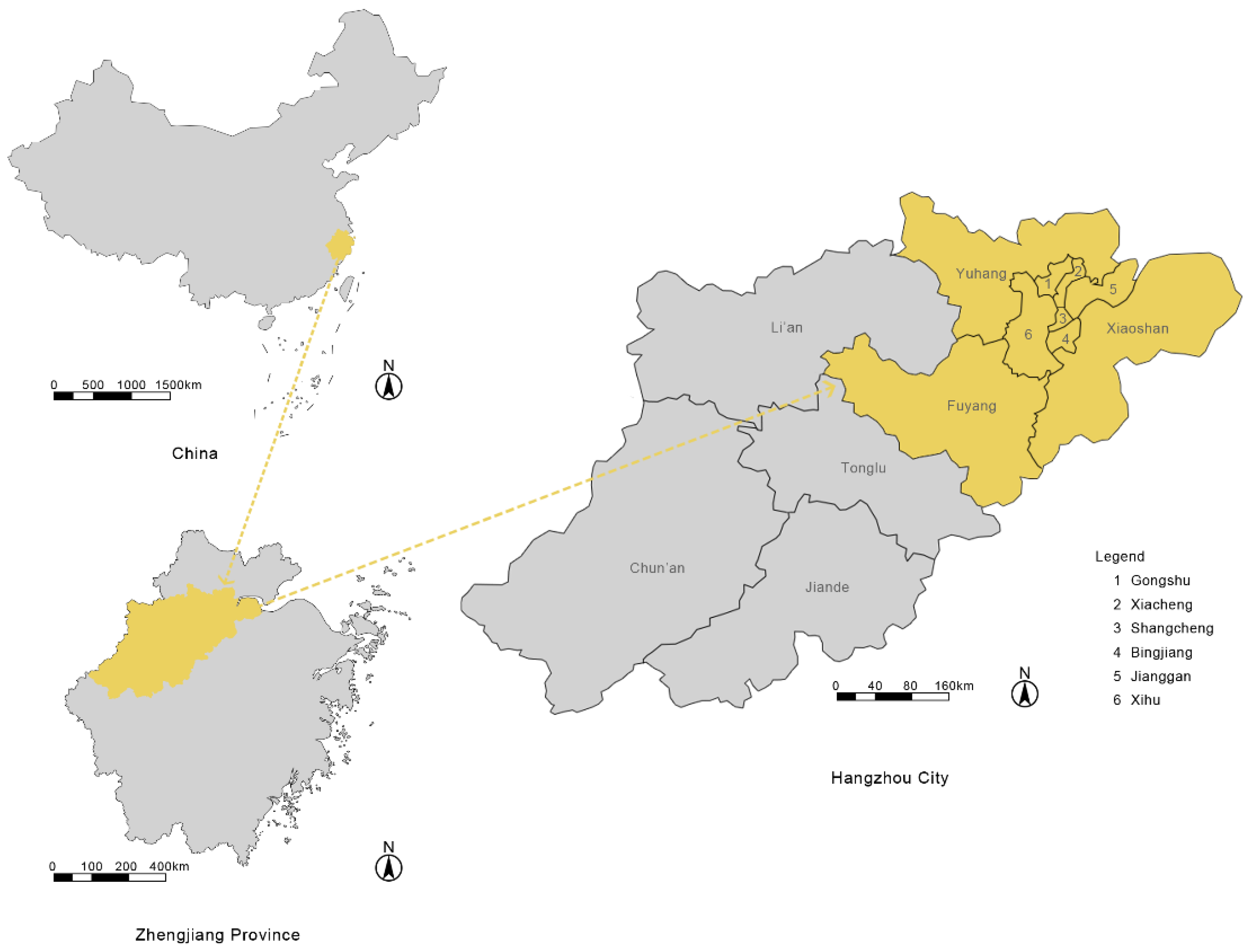
2.1. Study Area

Hangzhou (E 118°21′–120°30′, N 29°11′–30°33′), the capital of Zhejiang Province, is located in the north of the southeast coast of China and north of Zhejiang Province [35]. As shown in Figure 1, Hangzhou is located on the western edge of Hangzhou Bay and Shaoxing city, northeast of Quzhou city and Huangshan city (Anhui Province), south of Huzhou city and Jiaxing city, southeast of Xuancheng city (Anhui Province) [36]. Covering a total area of approximately 16,853 square kilometers, Hangzhou ranks as the second biggest city in Zhengjiang Province. There are 9 municipal districts (Gongshu, Shangcheng, Xiacheng, Jianggan, Xihu, Binjiang, Xiaoshan, Yuhang, Fuyang), 2 counties (Tonglu, Chun’an), and 2 county-level cities (Li’an, Jiande) in Hangzhou at present. Fuyang district was established on 13 December 2014, instead of Fuyang county-level city, which was approved by the China’s State Council [36]. In this study, the urban area (9 municipal districts, 5205.27 square kilometers) is the study area because the land use change in it was more obvious and dramatic than that in the countryside during the study period of time (1990–2017).
Having a long history, Hangzhou is listed as one of the China’s seven ancient capitals. Because of the beautiful scenery in the area of the West Lake, it is also known as “an earthly paradise” in China, and attracts a lot of tourists, including poets and artists. In addition, Hangzhou was an important commercial distribution center in history because of the convenience of the Beijing Hangzhou Great Canal and its trading ports, as well as its own developed silk and grain-processing industries. In the 21st century, with the promotion of high-tech enterprises such as Alibaba (a famous hi-tech and internet company in China) and other enterprises, Hangzhou is famous as one of the most important e-commerce centers in China. What’s more, it is also the political, economic, cultural, educational, transportation, and financial center in Zhejiang Province. By the end of 2017, the total GDP in Hangzhou was 12,556 billion yuan, which is 8% more than that of 2016.
Nowadays, as the second new first-tier city, Hangzhou is facing the coexistence of opportunity and challenge. Since the 2016 G20 Summit was held in Hangzhou, the Chinese government decided to build Hangzhou into a world famous city. High-tech enterprises attract more and more young people, which led to a dramatic increase in the urban population. By the end of 2017, the resident population in Hangzhou was about 9.5 million; it increased 280,000 in just one year. What’s more, the urban area of Hangzhou also expanded because of the development of county towns. There is no doubt that rapid growth of the urban area and population will bring a great deal of urban and environmental problems. The rapid economic development and frequent human activities in Hangzhou boost the urbanization, as various infrastructures were built so as to be compatible with the development of different industries [37,38]. For example, railways, airports, and highways were required to be upgraded, or the number of these infrastructures had to be increased [39]. Hence, a scientific and rigorous study of land use change in its urban area over a long period, i.e., from 1990 to 2017, will contribute to the future development of Hangzhou as a world famous city.

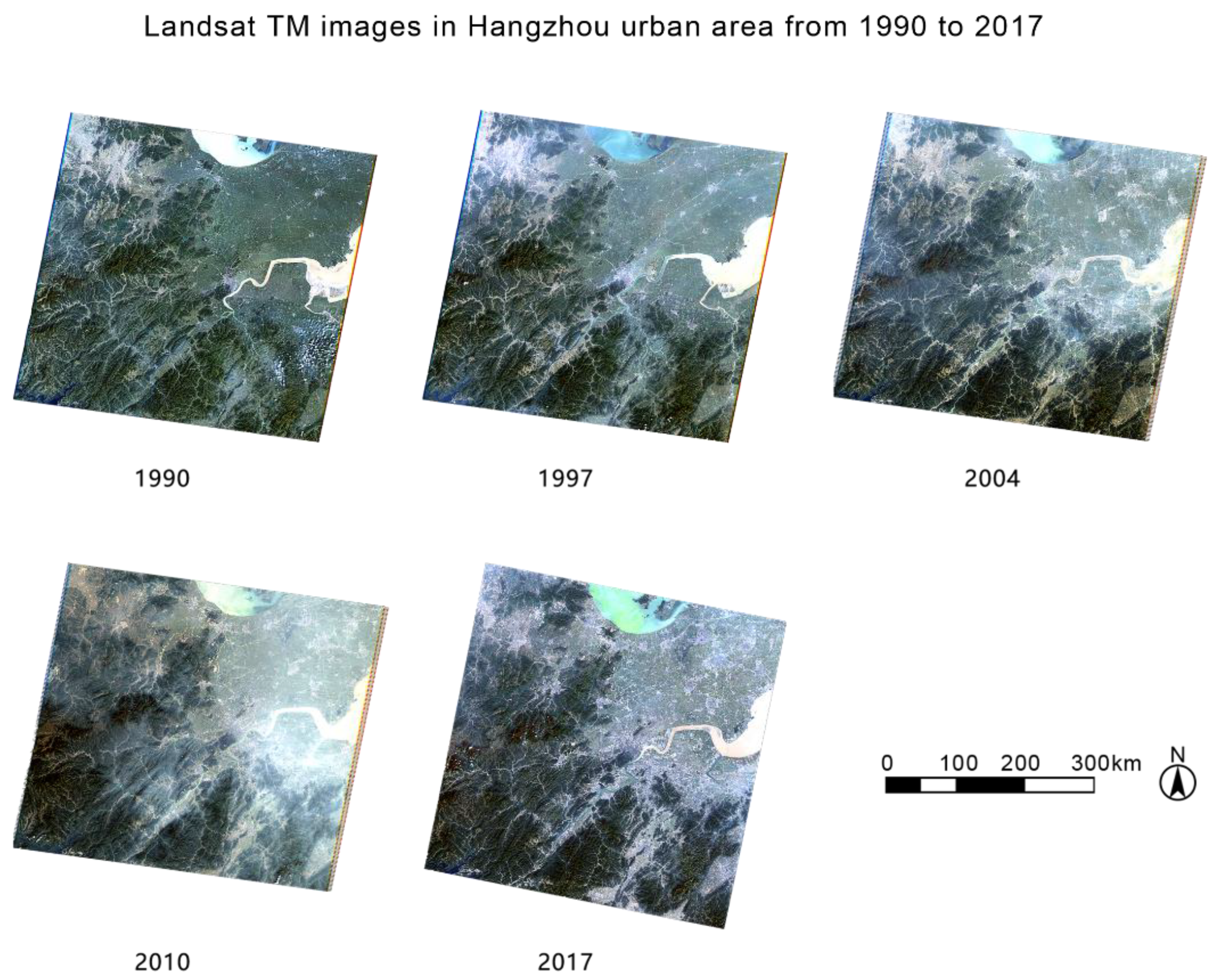
2.2. Data Collection

In order to analyze the spatial patterns in the Hangzhou urban area from 1990 to 2017 based on remote sensing, Landsat TM images should be chosen in almost the same season (the date intervals are ideal with no more than one month between dates). What’s more, the time intervals among the selected years should also be as equal as possible. In addition, the interference of sky clouds should also be considered when selecting Landsat TM images. After considering all these requirements, the images on 8 October 1990, 11 October 1997, 14 October 2004, 31 October 2010 and 3 November 2017 (Figure 2) were selected as data sources; detailed information is shown in Table 1.

2.3. Methods

In order to analyze land use change in Hangzhou from 1990 to 2017, image preprocessing is essential at the very beginning. After the images are cut according to the boundary line of Hangzhou urban area, land use classification maps will be the preliminary results of supervised classification, in which land use is divided into four types: built up areas (including urban fabric, industrial units, commercial buildings, transportation infrastructures, dump and construction sites, green urban areas, and leisure facilities), rural areas (includes cropland, paddy land, fish ponds and some scattered small village houses), forest, and water bodies. After post-processing, the land use classification maps were truly complete, and it is easy to see the changes in the values of different land use types in different years. Finally, a Markov matrix analysis of land use will be used to describe the change process.

2.3.1. Images Classification by the Method of Supervised Classification

In general, the classification methods of remote sensing images are mainly divided into supervised and unsupervised classification [40]. In this study, the method of supervised classification will be used to classify the land use types in Hangzhou urban area. Supervised classification is also called training classification; it is the process of identifying other unknown pixels with the recognized sample pixels. In this sort of classification, a certain number of training areas are selected for each category on the image [40]. By calculating this, each pixel and training samples are compared, and the most similar pixels are classified into the same sample-classes according to different rules. The main process of supervised classification comprises the following: (1) selecting feature bands and training areas; (2) selecting an algorithm; (3) classifying the image; (4) post-processing of image classification; (5) evaluating classification accuracy. In the second step, there are many different algorithms of supervised classification. Some of them are based on traditional statistical analysis, such as parallelepiped classification, minimum distance method, mahalanobis distance classification, and maximum likelihood classification. In addition, this includes neural networks, support vector machines, and spectral angle mapper classification etc. In this study, the support vector machine is chosen as the algorithm for land use change classification.
The support vector machine (SVM) for classification was first proposed by Corinna Cortes and Vladimir Vapnik in 1995 [41]. Structural risk theory, two optimization theory, and kernel space theory are the three basic theories of SVM. In general, SVM is a two-class classification model whose basic model is defined as a linear classifier with the largest interval in the feature space. That is to say, the learning strategy of the support vector machine is to maximize the interval, and finally, to transform it into a convex, two-degree programming problem. SVM provides a meaningful line of function complexity which is independent from the dimension of the problem. Using the pre-defined nonlinear transform function set, the vector is mapped to the high dimensional feature space, and the optimal hyperplane is generated according to the gap maximization principle of the support vector and the decision surface; then, the linear decision boundary of the high dimensional feature space is mapped to the nonlinear decision boundary of the input space [42]. SVM can automatically find the support vectors that have the ability to distinguish the classification, and thus, construct the classifier, thereby maximizing the interval between classes and classes, and having better generalization and higher classification accuracy.
A total of 150 training sites were manually selected by a region of interest (ROI) tool in ENVI for each image, to make sure that all spectral categories of land use are adequately expressed in the process of classification. What’s more, according to Google Maps and existing land use maps in Hangzhou urban area from 1990 to 2017, 50 training sites were chosen as samples to check the accuracy of classification by confusion matrix using ground truth ROIs in the post classification step.
In order to determine the accuracy and reliability of the classification, it is essential to evaluate the classification results. There are two methods to verify accuracy of classification: one is the confusion matrix, which is more commonly used; the other is a ROC (receiver operating characteristic) curve, which is more abstract with image expression. Overall classification accuracy and Kappa coefficient are the main evaluation indexes of the confusion matrix; a simple sample of a confusion matrix is shown in Table 2. Among them, overall classification accuracy equals the ratio of the number of correctly classified pixels (located in the diagonal of the confusion matrix table) to total pixels. The kappa coefficient was first proposed as a new tool by Jacob Cohen in 1960 [43,44,45,46,47]. The computational formulas of Cohen kappa coefficient is shown as Formulas (1)–(3).
K = P o P e 1 P e = 1 1 P o 1 P e  
P o = a + b a + b + c + d  
P e = P Y e s + P N o = a + b a + b + c + d a + c a + b + c + d + c + d a + b + c + d b + d a + b + c + d  
where, Po is the overall classification accuracy which equals the ratio of the number of correctly classified pixels to total pixels, Pe is the overall random agreement possibility, PYes is the expected possibility that both are “Yes” at random, and PNo is the expected possibility that both are “No” at random.
The value range of K is from −1 to 1, but K usually falls within the range from 0 to 1. What’s more, it can be divided into five groups to represent different levels of consistency: ① slight, 0.0–0.20; ② fair, 0.21–0.40; ③ moderate, 0.41–0.60; ④ substantial, 0.61–0.80; ⑤ almost perfect, 0.81–1 [48].

2.3.2. Analysis of Land Use Change Process by the Method of Markov Matrix

The finite first-order Markov process is a random process with the property that the value Xt at time t only depends on the value Xt−1 at time t − 1, and it is not related to the values of Xt−2, ..., X0. It is shown as follows:
P { X t = a j | X 0 = a 0 , X 1 = a 1 , , X t 1 = a i } = P { X t = a j | X t 1 = a i }  
where t = 0, 1, 2, ...
The possibility of a land use change from ai to aj in a period of time is a one-step transition possibility, P{Xt = aj|Xt−1 = ai}. When there is a homogeneous Markov chain [45], the transition possibility is shown as follows:
P { X t = a j | X t 1 = a i } = P i j  
and the transition possibility can be evaluated by the following formula:
P i j = n i j n i  
where nij is the number of times that the land use changed from state i to j, and ni is the number of times that land use type ai happened.
Considering all transition possibilities among all states, a transition matrix is proposed as follows:
P = ( p 11 p 12 p 1 m p 21 p 22 p 2 m p m 1 p m 2 p m n )  
So the transition matrix in n steps is easy to find by this formula:
P ( n ) = P n  

3. Results

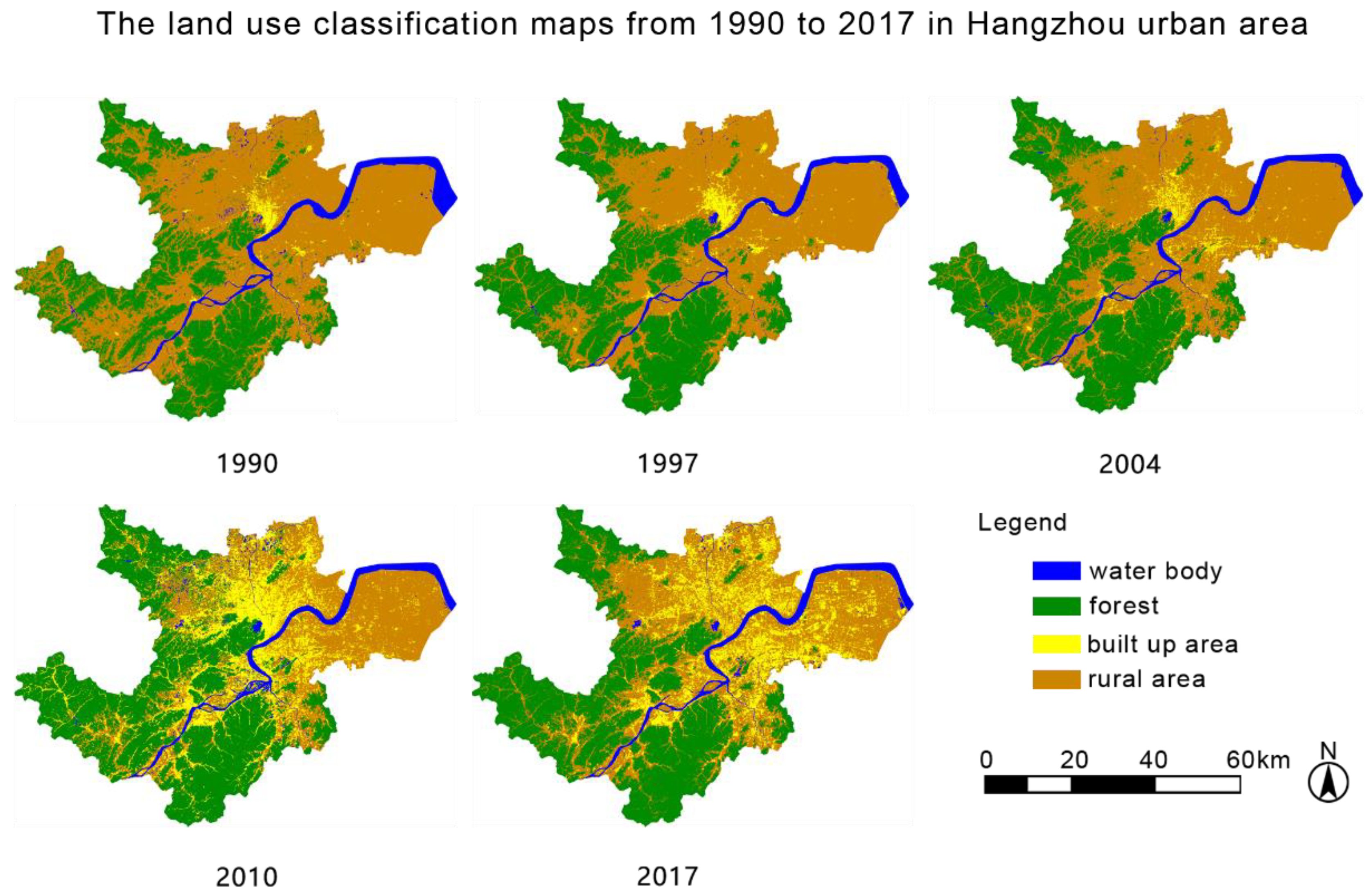
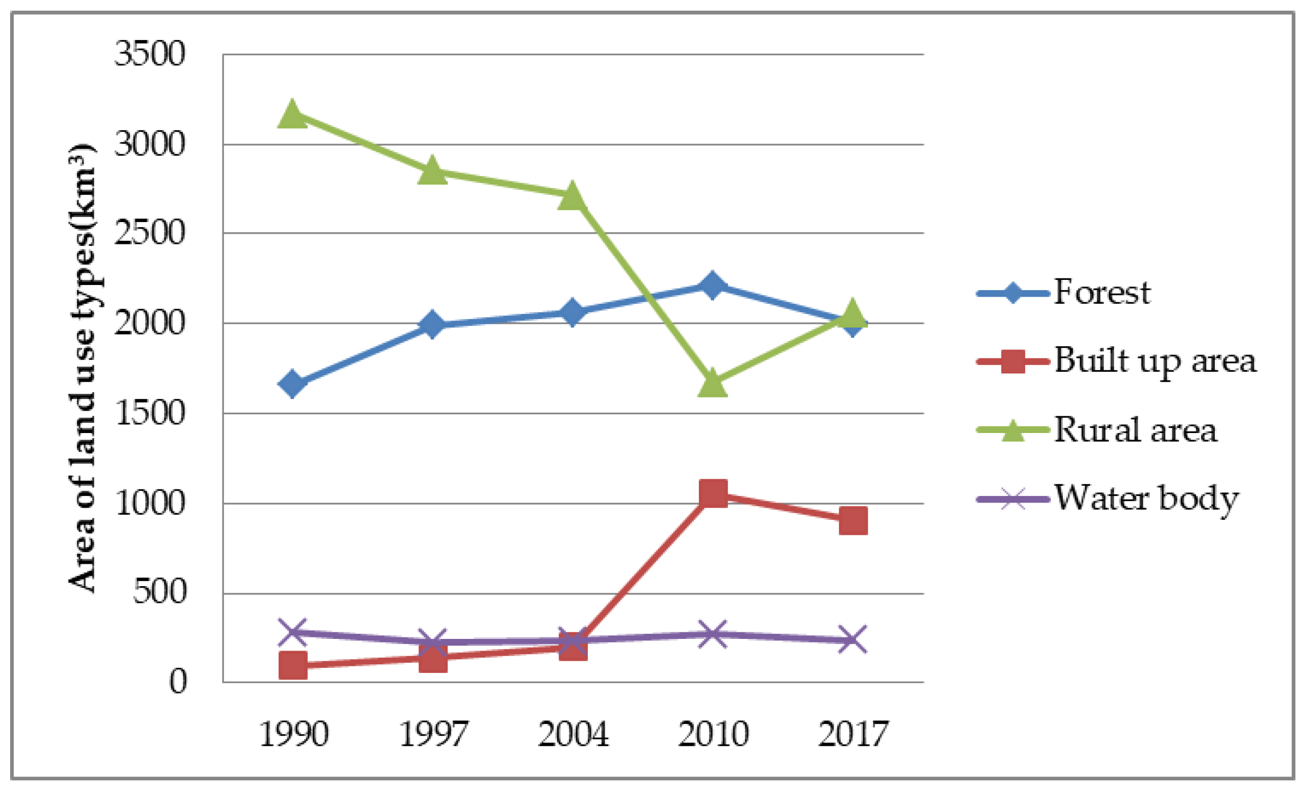
3.1. Classification Results from 1990 to 2017

After post-processing of image classification, the land use classification maps from 1990 to 2017 in Hangzhou are shown in Figure 3.
It is obvious that land use has changed dramatically from 1990 to 2017 in the Hangzhou urban area. From 1990 to 1997, there were two obvious changes: one was the expansion of forest area, and the other was the small area reclamation project in Hangzhou Bay. Until 2004, there were no dramatic changes, except slight expansion of built up area and decrease of rural area. By 2010, the built-up area boomed rapidly, and the center was mainly concentrated around the West Lake. Comparing the classification map from 2010 with that of 2017, it is easy to find that the built up area began to spread to the Xiaoshan District, and the too-dense situation of the original built up area around the West Lake was also improved. Obviously, the urban fabric of Hangzhou was integrated from 2010 to 2017.

3.2. Classification Accuracy

By the method of confusion matrix using ground truth ROIs with 50 training sites as samples, the results of classification accuracy for land use in Hangzhou urban area from 1990 to 2017 are shown in Table 3.
According to Table 3, it is obvious that the overall classification accuracies in 1990, 1997, 2004, 2010, and 2017 are over 90%. In addition, the Kappa coefficients in 1990, 1997, 2004, 2010, and 2017 are over 0.89, which means the results of the supervised classification are almost perfect according to the levels rules mentioned in the methodology.

3.3. Markov Matrix

The variation and percentage of each land use category in two years can reflect the degree of land use change in this period. In the study of land use change, a Markov matrix is a general method [45] to analyze the land use change of different types during a period of time as shown in Figure 4. Using the tool of confusion matrix using ground truth image in ENVI, the classification results of 1990 and 1997, 1997 and 2004, 2004 and 2010, 2010 and 2017, and 1990 and 2017 are compared with each other. In order to compare the total land use change of different types in different years, the results of Markov matrix are summarized in Table 4.

4. Discussion

According to Table 4 and Figure 4, it is clear that transition values (including area and percentage) are various among land types in different years. By analyzing these changes of land use types and comparing them with planning, policies, regulations, and natural conditions at that time, the factors causing these land use changes are summarized.

4.1. Analysis of Land Use Change from 1990 to 1997

The area of water bodies decreased by 57.64 km2 (20.508%), while retaining 214.78 km2 (76.423%) from 1990 to 1997. About 59.26 km2 of water bodies were transformed into rural areas. This may be related to the reclamation project in Hangzhou Bay, which is obvious in Figure 3. It may also be have been affected by the 1997 drought in China [49,50]. Furthermore, the forest area increased 329.47 km2 (19.836%), and the land type which is mainly converted into forest is rural area, which transformed 415.60 km2 (13.110%) into forest. There is no doubt that the changes between forest and rural areas are related to artificial afforestation initiated and implemented by the Chinese local government [51]. Finally, built-up areas increased by 44.77 km2 (48.063%) until 1997 in the initial stage of the process of urbanization [52].

4.2. Analysis of Land Use Change from 1997 to 2004

Except for built up areas, the changes of other types of land use are less than 5%. The increase area of built-up areas in Hangzhou from 1997 to 2004 is 61.54 km2 (44.620%), which is similar to the change of the previous period [53]. At this time, the local government introduced no new regulations to limit the use of rural areas to be converted into urban areas [54].

4.3. Analysis of Land Use Change from 2004 to 2010

It is obvious that built up areas increased rapidly by 851.08 km2 (426.667%), and that rural areas were the majority of all converted land into built up areas, although it was during the period of Global Economic Crisis. Definitely, the rapid expansion of urban areas was due to the policy of encouraging the rural population to live and work in cities [53]. At the same time, China’s GDP growth was more than 10% per year during this period [55]. Moreover, the forest area increased by 149.20 km2 (7.236%), which was also transformed from rural areas [56]. In other words, when most of the rural land is converted into urban land, part of the rural land has been transformed into forest [57]. This is because the Chinese central government released a new regulation to change rural farmland into forest in the early 2000’s [57,58].

4.4. Analysis of Land Use Change from 2010 to 2017

In contrast to previous periods of time, built-up area decreased by 145.32 km2 (13.833%) from 2010 to 2017. According to the master plan of Hangzhou and Figure 3, although the total amount of built-up area declined; the radiation range of the city has become larger because of scientific and systematic urban planning, in which the originally-dense city was transformed into a garden city with large area of green spaces and parks [59,60,61,62]. Compared to blindly focusing on the quantity in the past 20 years, China’s government has begun to pay close attention to the quality of city construction and planning. At the same time, China’s GDP growth has also begun to slow down, to make the urban planning more reasonable and suitable for people living in cities such as Hangzhou, China [63,64,65,66].

5. Conclusions

This article presents a case study for detecting land use changes in a rapid developing city from 1990–2017 using satellite imagery in Hangzhou, China. With the improvement of urbanization levels, land-use types are changing by human activities dramatically. In China, an obvious area of land use change is in the mega-cities, especially in first-tier cities and new first-tier cities, such as Hangzhou.
As one of the rapidly-developing first-tier cities in China, Hangzhou has experienced a great change of land use types during the past three decades. Detecting land use change over a designated period is beneficial for understanding the urbanization process in Hangzhou, and exercising more informed urban management and planning. In this study, we detected land use changes from 1990 to 2017 in the Hangzhou urban area using a method of supervised classification with Landsat TM images of 1990, 1997, 2004, 2010, and 2017. The results showed that from 1990 to 2017, a great deal of rural areas were transformed into built-up areas in Hangzhou urban area. Consequently, the urban area of Hangzhou increased eight times from 1990 to 2017. This may imply that such a big change is directly related to Chinese governmental policy, of which the main factor is rapidly-developing urbanization in Hangzhou and other similar cities. Thus, it is believed that China’s land use changes are going to be small over the following decades. This may indicate that China’s urban construction is slowing down, while its urban planning is being shifted from construction to management.

Author Contributions

Y.A. and Y.Z. conceived, designed, and performed the experiments, analyzed the data, and wrote the paper; K.W., D.L., and Y.L. improved the data analysis; J.Y.T. contributed reagents/materials/analysis tools.

Funding

This research was supported by the National Key Research and Development Program of China and (Project Ref. No. 2016YFB0501501) and the APC was funded by (Project Ref. No. 2016YFB0501501).

Acknowledgments

The data from the website of USGS and from the local government of Hangzhou are highly appreciated. This research is jointly supported by the National Key Research and Development Program of China (Project Ref. No. 2016YFB0501501) and the China-Italy Collaborate Project for lunar surface mapping (2016YFE0104400).

Conflicts of Interest

The authors declare no conflict of interest.

References

  1. FAO. Global Forest Resources Assessment 2015; FAO: Rome, Italy, 2016. [Google Scholar]
  2. Song, W.; Deng, X. Land-use/land-cover change and ecosystem service provision in China. Sci. Total Environ. 2017, 576, 705–719. [Google Scholar] [CrossRef] [PubMed]
  3. Li, Y.; Sulla-Menashe, D.; Mottesharrei, S.; Song, X.P.; Kalnay, E.; Ying, Q.; Li, S.; Ma, Z. Inconsistent estimate of forest cover change in China between 2000 and 2013 from multiple datasets: Differences in parameters, spatial resolution, and definitions. Sci. Rep. 2017, 7. [Google Scholar] [CrossRef] [PubMed]
  4. Geist, H.J.; Lambin, E.F. Proximate causes and underlying forces of tropical deforestation. BioScience 2002, 52, 143–150. [Google Scholar] [CrossRef]
  5. Nepstad, D.C.; Stickler, C.M.; Almeida, O.T. Globalization of the Amazon soy and beef industries: Opportunities for conservation. Conserv. Biol. 2006, 20, 1595–1602. [Google Scholar] [CrossRef] [PubMed]
  6. Rudel, T.K. Tropical Forests: Regional Paths of Destruction and Regeneration in the Late Twentieth Century; Columbia University Press: New York, NY, USA, 2005. [Google Scholar]
  7. Bounoua, L.; DeFries, R.; Collatz, G.; Sellers, P.; Khan, H. Effects of land cover conversion on surface climate. Clim. Chang. 2002, 52, 29–64. [Google Scholar] [CrossRef]
  8. Bonan, G.; Pollard, D.; Thompson, S. Effects of boreal forest vegetation on global climate. Nature 1992, 359, 716–718. [Google Scholar] [CrossRef]
  9. Kleidon, A.; Fraedrich, K.; Heimann, M. A green planet versus a desert world: Estimating the maximum effect of vegetation on the land surface climate. Clim. Chang. 2000, 44, 471–493. [Google Scholar] [CrossRef]
  10. Giam, X. Global diversity loss from tropical deforestation. Proc. Natl. Acad. Sci. USA 2017, 114, 5775–5777. [Google Scholar] [CrossRef] [PubMed]
  11. Wang, L.; Li, C.; Ying, Q.; Cheng, X.; Wang, X.; Li, X.; Hu, L.; Liang, L.; Yu, L.; Huang, H.; et al. China’s urban expansion from 1990 to 2010 determined with satellite remote sensing. Chin. Sci. Bull. 2012, 57, 2802–2812. [Google Scholar] [CrossRef] [Green Version]
  12. National Bureau of Statistics of the People’s Republic of China. Statistical Bulletin on National Economic and Social Development in 2017; National Bureau of Statistics of the People’s Republic of China: Beijing, China, 2018.
  13. The Department of Economic and Social Affairs of the United Nations. World Urbanization Prospects 2018; The Department of Economic and Social Affairs of the United Nations: New York, NY, USA, 2018. [Google Scholar]
  14. Top 15 ‘new first-tier’ cities in China. China Daily. 15 May 2017. Available online: http://www.chinadaily.com.cn/business/2017top10/2017-05/15/content_29343927.htm (accessed on 8 June 2018).
  15. National Bureau of Statistics of the People’s Republic of China. The Forth National Census; National Bureau of Statistics of the People’s Republic of China: Beijing, China, 1990.
  16. National Bureau of Statistics of the People’s Republic of China. The Sixth National Census; National Bureau of Statistics of the People’s Republic of China: Beijing, China, 2011.
  17. Du, X.; Huang, Z. Ecological and environmental effects of land use change in rapid urbanization: The case of Hangzhou, China. Ecol. Indic. 2017, 81, 243–251. [Google Scholar] [CrossRef]
  18. Tian, Y.; Xia, Y.; Zhou, L.; Li, D. Land use and cover change simulation and prediction in hangzhou city based on CA-markov model. Int. Proc. Chem. Biol. Environ. Eng. 2015, 90, 108–113. [Google Scholar]
  19. Wu, K.; Ye, X.; Qi, Z.; Zhang, H. Impacts of land use/land cover change and socioeconomic development on regional ecosystem services: The case of fast-growing Hangzhou metropolitan area, China. Cities 2013, 31, 276–284. [Google Scholar] [CrossRef]
  20. Zvoleff, A.; Wandersee, S.; An, L.; López-Carr, D. Land use and cover change. In Geography, Oxford Bibliographies; Oxford University Press: Oxford, UK, 2014. [Google Scholar]
  21. Li, X. A review of the international researches on land use/land cover change. Acta Geogr. Sin. 1996, 6, 344–356. [Google Scholar]
  22. Lavalle, C.; Baranzelli, C.; Silva, F.B.E.; Mubareka, S.; Gomes, C.R. A high resolution land use/cover modelling framework for Europe: Introducing the EU-ClueScanner100 model. Lect. Notes Comput. Sci. 2011, 6782, 60–75. [Google Scholar]
  23. Turner, B.L., II; Lambin, E.F.; Reenberg, A. The emergence of land change science for global environmental change and sustainability. Proc. Natl. Acad. Sci. USA 2007, 104, 20666–20671. [Google Scholar] [CrossRef] [PubMed] [Green Version]
  24. Reidsma, P.; Tekelenburg, T.; Berg, M.M.; van den Alkemade, R. Impacts of land-use change on biodiversity: An assessment of agricultural biodiversity in the European Union. Agric. Ecosyst. Environ. 2006, 114, 86–102. [Google Scholar] [CrossRef]
  25. Honnay, O.; Piessens, K.; van Landuyt, W.; Hermy, M.; Gulinck, H. Satellite based land use and landscape complexity indices as predictors for regional plant species diversity. Landsc. Urban Plan. 2006, 63, 241–250. [Google Scholar] [CrossRef]
  26. Mao, D.; Keith, A. Cherkauer, impacts of land-use change on hydrologic responses in the great lakes region. J. Hydrol. 2009, 374, 71–82. [Google Scholar] [CrossRef]
  27. Searchinger, T.; Heimlich, R.; Houghton, R.A.; Dong, F.; Elobeid, A.; Fabiosa, J.; Tokgoz, S.; Hayes, D.; Yu, T.-H. Use of U.S. croplands for biofuels increases greenhouse gases through emissions from land-use change. Science 2008, 319, 1238–1240. [Google Scholar] [CrossRef] [PubMed]
  28. Li, J.; Li, C.; Zhu, F.; Song, C.; Wu, J. Spatiotemporal pattern of urbanization in Shanghai, China between 1989 and 2005. Landsc. Ecol. 2013, 28, 1545–1565. [Google Scholar] [CrossRef]
  29. Simwanda, M.; Murayama, Y. Spatiotemporal patterns of urban land use change in the rapidly growing city of Lusaka, Zambia: Implications for sustainable urban development. Sustain. Cities Soc. 2018, 39, 262–274. [Google Scholar] [CrossRef]
  30. Yu, W.; Zang, S.; Wu, C.; Liu, W.; Na, X. Analyzing and modeling land use land cover change (LUCC) in the Daqing City, China. Appl. Geogr. 2011, 31, 600–608. [Google Scholar] [CrossRef]
  31. Pazúr, R.; Bolliger, J. Land changes in Slovakia: Past processes and future directions. Appl. Geogr. 2017, 85, 163–175. [Google Scholar] [CrossRef]
  32. Li, X.; Yeh, A.G. Neural-network-based cellular automata for simulating multiple land use changes using GIS. Int. J. Geogr. Inf. Sci. 2010, 16, 323–343. [Google Scholar] [CrossRef]
  33. Deadman, P.; Robinson, D.; Moran, E.; Brondizio, E. Colonist household decision making and land-use change in the Amazon Rainforest: An agent-based simulation. Environ. Plan. B 2004, 31, 693–709. [Google Scholar] [CrossRef]
  34. Liu, J.; Liu, M.; Zhuang, D.; Zhang, Z.; Deng, X. Study on spatial pattern of land-use change in china during 1995–2000. Sci. China Ser. D 2003, 46, 373–384. [Google Scholar]
  35. Xin, W. Economic and Social Development Report on Hangzhou Metropolitan Circle (2007–2012); Social Sciences Academic Press: Beijing, China, 2013. (In Chinese) [Google Scholar]
  36. China Internet Information Center. Illuminating China’s Provinces, Municipalities and Autonomous Region. PRC Central Government Official Website. 2001. Available online: http://www.china.org.cn/english/features/43610.htm (accessed on 8 June 2018).
  37. Canning, D.; Pedroni, P. Infrastructure, long-run economic growth and causality tests for cointegrated panels. Manch. Sch. 2008, 76, 504–527. [Google Scholar] [CrossRef]
  38. Xiong, C.; Becmann, V.; Tan, R. Effects of infrastructure on land use and land cover change (LULC): The case of Hangzhou international airport, China. Sustainability 2018, 10, 2013. [Google Scholar] [CrossRef]
  39. Li, B.; Mayraz, G. Infrastructure spending in china increase trust in local government. Soc. Indic. Res. 2017, 132, 341–356. [Google Scholar] [CrossRef]
  40. Weng, Q. Land use change analysis in the Zhujiang delta of China using satellite remote sensing, GIS and stochastic modelling. J. Environ. Manag. 2002, 64, 273–284. [Google Scholar] [CrossRef]
  41. Michael, R.; Muller, J.M. A markov model of land-use change dynamics in the Niagara Region, Ontario, Canada. Landsc. Ecol. 1994, 9, 151–157. [Google Scholar]
  42. Wu, Q.; Li, H.; Wang, R.; Paulussen, J.; He, Y.; Wang, M.; Wang, B.-H.; Wang, Z. Monitoring and predicting land use change in Beijing Using remote sensing and GIS. Landsc. Urban Plan. 2006, 78, 322–333. [Google Scholar] [CrossRef]
  43. Cortes, C.; Vapnik, V. Support-vector networks. Mach. Learn. 1995, 20, 273–297. [Google Scholar] [CrossRef] [Green Version]
  44. Wang, Y.; Li, J. A review of land use/cover classification methods for remote sensing images. Remote Sens. Inf. 2004, 1, 53–59. [Google Scholar]
  45. Kumar, S.; Radhakrishnan, N.; Mathew, S. Land use change modelling using Markov model and remote sensing. Geomat. Nat. Hazards Risk 2014, 5, 145–156. [Google Scholar] [CrossRef]
  46. Cohen, J. A coefficient of agreement for nominal scales. Educ. Psychol. Meas. 1960, 20, 37–46. [Google Scholar] [CrossRef]
  47. Landis, J.R.; Koch, G.G. The measurement of observer agreement for categorical data. Biometrics 1977, 33, 159–174. [Google Scholar] [CrossRef] [PubMed]
  48. Zanotta, D.C.; Zortea, M.; Ferreira, M.P. A supervised approach for simultaneous segmentation and classification of remote sensing images. ISPRS J. Photogramm. Remote Sens. 2018, 142, 162–173. [Google Scholar] [CrossRef]
  49. Chen, W.; Wang, D.; Huang, Y.; Chen, L.; Zhang, X.; Sang, M.; Wang, F.; Liu, J.; Hu, H. Monitoring and analysis of coastal reclamation from 1995–2015 in Tainjin Binhai New Area, China. Sci. Rep. 2017, 7. [Google Scholar] [CrossRef]
  50. Mu, J.B.; Huang, S.C.; Lou, H.F. Effects of the large-scale reclamation project on hydro-dynamic environment in the estuary. Appl. Mech. Mater. 2012, 226–228, 2317–2322. [Google Scholar] [CrossRef]
  51. Peng, S.; Chen, L.; Li, T. Reforming China: Major events (1978–1991). In Enrich Series on China’s Economic Reform; Enrich Professional Publishing: London, UK, 2010. [Google Scholar]
  52. Zhou, J. Interpretation of urbanization mechanism with system theories. Urban Stud. 1997, 4, 51–54. [Google Scholar]
  53. Li, L.; Lu, D.; Kuang, W. Examining urban impervious surface distribution and its dynamic change in Hangzhou metropolis. Remote Sens. 2016, 8, 265. [Google Scholar] [CrossRef]
  54. Wei, Y.D. Planning Chinese cities: The limit of transitional institutions. Urban Geogr. 2005, 16, 200–221. [Google Scholar] [CrossRef]
  55. Lin, F.; Sun, Q.; Peng, Z.; Chen, X. The innovations in China’s primary health care reform: Development and characteristics of the community health service in Hangzhou. Fam. Med. Commun. Health 2015, 3, 52–66. [Google Scholar] [CrossRef]
  56. Zhang, L.; Yue, W.; Liu, Y.; Fan, P.; Wei, Y.D. Suburban industrial land development in transitional China: Spatial restructuring and determinants. Cities 2018, 78, 96–107. [Google Scholar] [CrossRef]
  57. Shi, K.; Chen, Y.; Yu, B.; Xu, T.; Li, L.; Huang, C.; Liu, R.; Chen, Z.; Wu, J. Urban expansion and agricultural land loss in China: A multiscale perspective. Sustainability 2016, 8, 790. [Google Scholar] [CrossRef]
  58. Yue, W.; Liu, Y.; Fan, P. Polycentric urban development: The case of Hangzhou. Environ. Plan. A 2010, 42, 563–577. [Google Scholar] [CrossRef]
  59. You, H. Assessing land ecological security based on BP neural network: A case study of Hangzhou, China. J. Comput. 2013, 8, 1394–1400. [Google Scholar] [CrossRef]
  60. Spiekermann, M.; He, Y.; Yang, J.; Pauleit, S. Hangzhou: Fast urbanization and high population growth. In Peri-Urban Futures: Scenarios Models for Land Use Change in Europe; Springer: Berlin, Germany, 2018. [Google Scholar]
  61. Viña, A.; McConnell, W.J.; Yang, H.; Xu, Z.; Liu, J. Effects of conservation policy on China’s forest recovery. Sci. Adv. 2016, 2. [Google Scholar] [CrossRef] [PubMed]
  62. Banister, D.; Liu, J. Urban transport and the environment, Hangzhou, China. In Case Study Prepared for Global Report on Human Settlements; Nairobi, United Nations, 2013. Available online: https://unhabitat.org/wp-content/uploads/2013/06/GRHS.2013.Case_.Study_.Hangzhou.China_.pdf (accessed on 8 June 2018).
  63. Huang, J.W.; Teng, W.; Galliers, R. Transitioning beyond the economic-environmental trade-off in the city of Hangzhou. In Proceedings of the Annual Meeting of the Academy of Management, Anaheim, CA, USA, 5–9 August 2016. [Google Scholar]
  64. Tsou, J.Y.; Gao, Y.; Zhang, Y.; Sun, G.; Ren, J.; Li, Y. Evaluating urban land carrying capacity based on the ecological sensitivity analysis: A case study in Hangzhou, China. Remote Sens. 2017, 9, 529. [Google Scholar] [CrossRef]
  65. Wang, H.; Zhang, Y.; Tsou, J.Y.; Li, Y. Surface urban heat island analysis of Shanghai (China) based on the change of land use and land cover. Sustainability 2017, 9, 1538. [Google Scholar] [CrossRef]
  66. Wong, K.; Zhang, Y.; Tsou, J.Y.; Li, Y. Assessing impervious surface changes in sustainable coastal land use: A case study in Hong Kong. Sustainability 2017, 9, 1029. [Google Scholar] [CrossRef]
Figure 1. Location of study area in Hangzhou, China.
Sustainability 10 03303 g001
Figure 2. Landsat TM images in Hangzhou urban area from 1990 to 2017.
Sustainability 10 03303 g002
Figure 3. The land use classification maps from 1990 to 2017 in Hangzhou urban area.
Sustainability 10 03303 g003
Figure 4. Land-use change trends from 1990 to 2017 in Hangzhou urban area.
Sustainability 10 03303 g004
Table 1. Data sources information in this study.
DateType of ImageNo. of BandsSun Elevation (degree)Sun Azimuth (degree)
8 October 1990TM644.38789220137.22180616
11 October 1997TM645.42697568142.52459223
14 October 2004TM645.83292862147.08323317
31 October 2010TM641.42500448152.91220365
3 November 2017TM741.43678741156.63973651
Table 2. Sample of confusion matrix.
B
YesNo
AYesab
Nocd
Table 3. Results of classification accuracy for land use in Hangzhou urban area.
Landsat TM ImagesOverall Classification AccuracyKappa Coefficient
199097.6105%0.9621
199799.3119%0.9894
200496.3759%0.9444
201098.1455%0.9718
201792.6960%0.8941
Table 4. Summary of land use change results from 1990 to 2017.
Land Use TypeForestBuilt up AreaRural AreaWater Body
Years and Change
1997
(compared with 1990)
Into the area (km2)1990.44137.932853.50223.41
Out of the area (km2)1660.9693.153170.12281.04
Change area (km2)329.4744.77−316.62−57.64
Change percentage (%)19.83648.063−9.988−20.508
2004
(compared with 1997)
Into the area (km2)2061.85199.472713.24230.71
Out of the area (km2)1990.44137.932853.50223.41
Change area (km2)71.4261.54−140.267.30
Change percentage (%)3.58844.620−4.9153.269
2010
(compared with 2004)
Into the area (km2)2211.061050.551673.74269.93
Out of the area (km2)2061.85199.472713.24230.71
Change area (km2)149.20851.08−1039.5039.22
Change percentage (%)7.236426.667−38.31217.000
2017
(compared with 2010)
Into the area (km2)2004.83905.232057.79237.43
Out of the area (km2)2211.061050.551673.74269.93
Change area (km2)−206.23−145.32384.05−32.50
Change percentage (%)−9.327−13.83322.946−12.039
2017
(compared with 1990)
Into the area (km2)2004.83905.232057.79237.43
Out of the area (km2)1660.9693.153170.12281.04
Change area (km2)343.86812.07−1112.33−43.61
Change percentage (%)20.703871.749−35.088−15.518

