Article

Remote Sensing and GIS Support to Identify Potential Areas for Wetland Restoration from Cropland: A Case Study in the West Songnen Plain, Northeast China

Key Laboratory of Wetland Ecology and Environment, Northeast Institute of Geography and Agroecology, Chinese Academy of Sciences, Changchun 130102, China
*
Author to whom correspondence should be addressed.
Sustainability 2018, 10(7), 2375; https://doi.org/10.3390/su10072375
Submission received: 18 May 2018 / Revised: 2 July 2018 / Accepted: 2 July 2018 / Published: 9 July 2018
(This article belongs to the Section Environmental Sustainability and Applications)

Abstract

:
Wetland restoration is important to responding to climate change and ensuring ecological security. In terms of the serious wetland loss and limited wetland restoration in China, there is a need to investigate approaches to identifying potential areas for wetland restoration from cropland, in order to support making spatial decisions at a regional scale. Here, we provide an example of integrating remote sensing (RS) and geographical information systems (GIS) effectively to identify where and how many croplands could be converted into wetlands in the West Songnen Plain (WSNP). The map of potential areas for wetland restoration from croplands generated in this study is expected to help decision makers to implement wetland restoration in the WSNP. Besides the widely highlighted hydrological, topographical, and landscape features, four indicators, namely, flooded area, time under cultivation, human disturbance, and wetland conservation level, were selected to identify the potential areas for wetland restoration—with different priorities—from croplands. Satellite observation revealed that a total of 2753.3 km2 of wetlands have been cultivated into croplands for grain production from 1990 to 2015 in the WSNP. It is estimated that 8882.1 km2 of croplands are suitable for conversion to wetlands, of which 3706 km2 (29.4%) are with high priority, and 44.5% are from dry farmlands. A total of 3284.7 km2 of paddy fields are identified to be potential areas for wetland restoration, of which 1119.6 km2 are high priority, and another 2165.1 km2 are medium priority.

1. Introduction

Wetlands are valuable to humans due to their notable ecosystem functions and services, such as protecting biodiversity, adjusting hydrology and climate, and providing important habitats, products, and tourism resources [1,2]. Intensive human activities and climate change worldwide, however, have led to extensive wetland loss [3,4,5]. Such losses also have caused pronounced ecological consequences including floods [6], biodiversity loss [7], coastal damage [8], water quality degradation [9], and carbon sequestration decline [10,11]. Therefore, human efforts should respond to these wetland losses and associated negative consequences.
Wetland restoration projects are an important approach to achieving wetland ecosystem conservation and sustainable management [12]. To perform effective wetland restoration, the first necessary step is to identify the potential areas. In past decades, multiple methods and indicators were used to do such work [13]. For example, O’Neill et al. [14] employed a wetness index to develop a conceptual model for identifying restoration sites for riparian wetlands within the Upper Arkansas River basin in Colorado, United States. Huang et al. [15] attempted to select sites for converting cropland to wetland in China’s Sanjiang Plain through the use of indexes for wetness and cropland productivity. Potential restoration areas of freshwater wetlands in the Yellow River Delta in China were identified by assessing habitat suitability [16]. All these studies highlighted the importance of hydrology and terrain conditions for restoring wetlands. However, many other important indicators have not yet been adequately considered in designing a site selection system for wetland restoration. For example, the duration of farming, which relates to the availability of the soil seed bank, is an important indicator of natural wetland restoration [17,18]. Human disturbances and conservation using protected areas should be considered in planning restoration priorities. For example, agricultural activities in the core and experimental zones of nature reserves should be prohibited. Therefore, there is a need to improve the indicator system for scientific decision support to achieve effective wetland restoration.
Previous studies also indicated that remote sensing (RS) and geographic information systems (GIS) were important data sources and tools in supporting spatial decisions for wetland restoration [19,20]. RS can characterize the current situation of the land surface, and also provide historical data contributing to the assessment of restoration suitability [21]. With GIS software, much spatial analysis can be performed, such as overlay and buffer analyses. Therefore, by selecting suitable indicators and designing scientific criteria based on both RS and GIS technologies, identifying potential areas for wetland restoration is feasible.
China developed a national wetland conservation action plan in 2000, which made a set of ambitious goals, including the intention to restore an area of 1.4 × 10⁹ ha [22]. As reported by Mao et al. [21], there were only 1369 km2 of natural wetlands that were restored from cropland over the period from 1990–2010, accounting for 8.7% of the natural wetland loss due to crop cultivation. Northeast China should perform more natural wetland restoration projects, because the proportional area of natural wetlands restored from cropland was much smaller than its contribution to the agricultural encroachment of natural wetlands in the whole of China [21].
The West Songnen Plain (WSNP), located in central Northeast China, is an important geographic region because of its role in protecting biodiversity, providing critical habitat for migrating waterfowls, and regulating regional climate [23]. However, WSNP was also identified as a hotspot area of wetland loss in several studies [24]. Wang et al. [25] revealed that WSNP experienced considerable shrinkage and fragmentation of wetlands from the 1950s to 2008, which can be mostly attributed to agricultural encroachment and a drier climate. In the recent decades, another study [21] also documented that the extensive loss of wetlands over the WSNP was largely related to cropland expansion during 1990–2010. The areal decline in wetlands has caused obvious ecological consequences, such as loss of the habitat of the red-crowned crane and the white crane, and decreased capacity in abating floods. Although the importance of wetlands in the WSNP have been recognized by China’s central and local governments, and wetland restoration projects have been performed in some plots since the 1990s [21], policies for grain production and ecological security are still conflicting factors. In response to these ecological issues, and in the pursuit of a balance between food demand and ecological conservation, we should know how many wetlands there are, and which ones can be restored from croplands in the WSNP. But such information is limited. A spatially explicit map for potential area and priority of wetland restoration for the WSNP is unavailable; this is urgently needed for regional sustainable ecosystem management.
For contributing to scientific wetland restoration and sustainable ecosystem management, this paper aims to determine the potential area for wetland restoration from croplands with different priorities in the WSNP, based on RS and GIS technology. For this purpose, we specifically intend (1) to map the land cover and examine the wetland loss encroached upon by cropland expansion; (2) to document different indicators and their criteria for wetland restoration; (3) and to discuss the advantages of RS and GIS in supporting spatial decisions for wetland restoration and management implications. This study is expected to guide the implementation of restoration projects and provide scientific method instruction for wetland restoration in other regions or on larger scales.

2. Materials and Methods
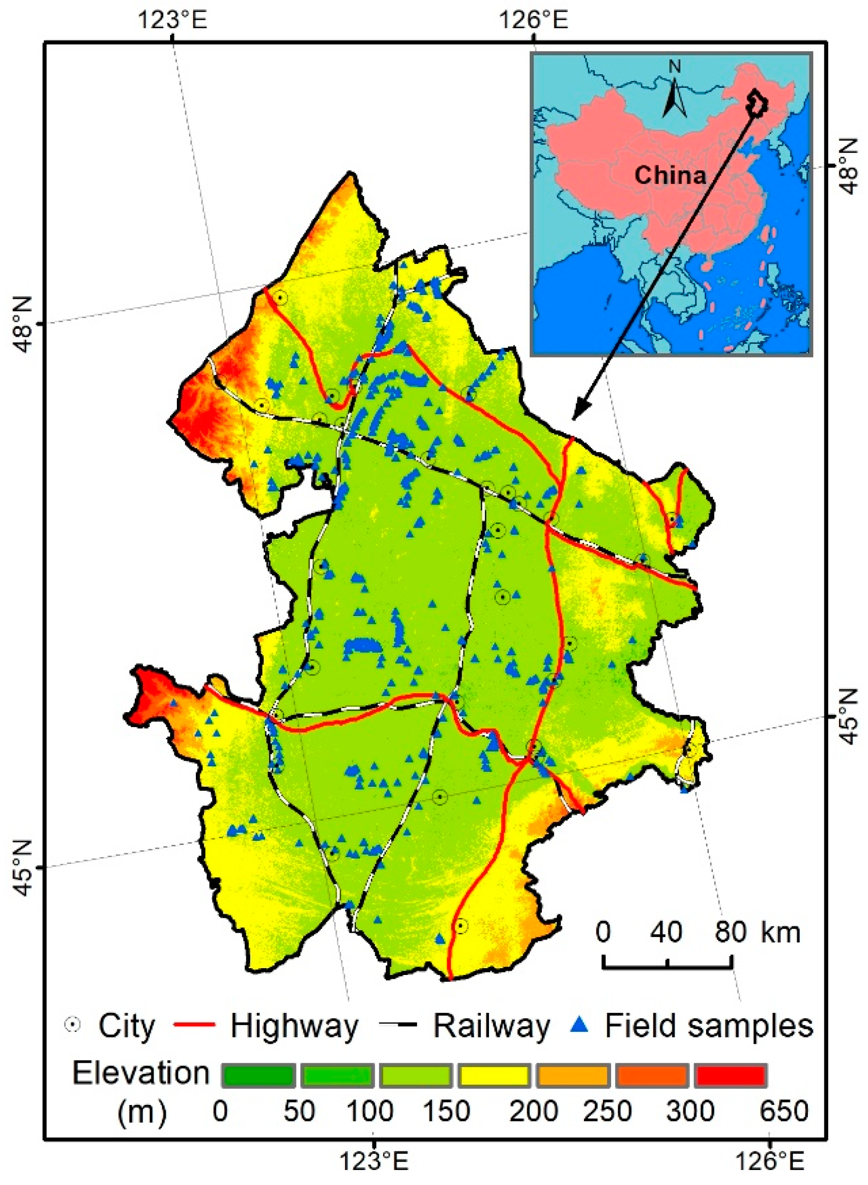
2.1. Study Area

The West Songnen Plain is located in the central part of Northeast China, extending from 44° N to 48°33’ N and from 121°38’ E to 126°38’ E, and covering 22 counties, with a total area of 1.02 × 10⁵ km2 (Figure 1). The study area is characterized by a temperate, semiarid, continental monsoon climate. Air temperature spatially increases from north to south, with a mean annual value of 3.6 °C when summer is warm and winter is cold. Annual precipitation varies remarkably from 350 to 650 mm, while mean potential evapotranspiration is 1100 mm. Over the past decades, WSNP experienced significant increases in air temperatures and dryness, and decreased precipitation [25]. Changing hydrological regimes affects the wetland systems [25]. WSNP is a typical ecotone between agriculture and pasture in northern China, and is ecologically sensitive to human activities and climate change. Excluding extensive croplands, dominant natural land cover is grasslands and wetlands. Dominant soil types are chernozem, chestnut soil, meadow soil, and aeolian soil [26]. Major rivers, including Songhuajiang, Nenjiang, and Taoerhe, flow through this region, while many lakes and reservoirs, including the largest Chaganhu Lake and Nierji Reservoir, are sparsely distributed in the study area. Large areas of wetlands were thus observed in the study area.
WSNP is recognized as providing important habitats to a large number of migrating waterfowls in the East Asia–Australasian Flyway (EAAF). Accordingly, five natural reserves were designed at the national level, while seven reserves were designed at the provincial level. In addition, three national nature reserves have been listed in the Ramsar Sites of Wetlands with International Importance. Due to significant human disturbances, especially agricultural activities and climate change, the wetlands in this ecologically sensitive region have been damaged to a remarkable degree [25]. Ecological conservation and restoration is thus necessary for biodiversity and ecological security.

2.2. Land Cover Dataset

To aid in generating multiple indicators for wetland restoration and understanding wetland changes across the WSNP, land cover data sets in 1990, 2000, 2005, 2010, and 2015 were obtained. The land cover data sets in the former four dates were extracted from the China National Land Cover Database (ChinaCover), which was developed by the Chinese Academy of Sciences [24,27]. ChinaCover was designed to examine the ecological changes in China based on object-oriented image classification methods and multisource satellite images. This database achieved good classification accuracy, i.e., greater than 88%, and has been widely used [28,29]. For an accurate assessment of wetland loss, we made further visual revisions of these datasets. Based on the Landsat images provided by the U.S. Geological Survey (USGS) and land cover in 2010, a change-detection algorithm and visual interpretation were used to generate the land cover in 2015. In this process, substantial field samples (Figure 1) carried out in 2015, and high-resolution images from Google Earth, were used to improve object recognition. Classification accuracy for the land cover dataset in 2015 was assessed through independent ground surveys, indicating an overall accuracy of 94%.
In this study, the land cover was categorized into seven types, namely, woodland, grassland, wetland, waterbody, cropland, built-up land, and bare land, as shown in Table 1. Particularly, we separated “waterbody” from “wetland” in this study to document the hydrological conditions. “Wetland” in our study refers only to marsh, which is the only wetland type covered by vegetation. “Cropland” is also classified as two types: dry farmlands and paddy fields. In May and June, these two types are easily distinguishable from satellite images due to the use of irrigation in paddy fields.

2.3. Indicators for Wetland Restoration

To identify potential areas for wetland restoration, six indicators were selected. A detailed introduction to these indicators is given below.

2.3.1. Distribution of Wetland Lost to Cropland

In this study, natural land covers such as woodland and grassland would not require extensive restoration. Therefore, we only focused on cropland. Before we perform wetland restoration from cropland, it is necessary to know the location of wetlands lost to cropland. In addition, the duration of farming is also important to natural restoration because it is easier to restore the natural wetland vegetation from the soil seed bank in croplands with a shorter duration of farming [17]. This information could be characterized by the conversions between the land cover in different years. Wang et al. [18] revealed that important wetland vegetation survived cultivation as seeds for 10 years. Therefore, we assigned high restoration priority to the croplands cultivated from wetlands during the periods 2010–2015 and 2005–2010, and medium priority to the croplands cultivated from wetlands during periods 2000–2005 and 1990–2000.

2.3.2. Hydrological Condition and Flood Monitoring

Hydrological conditions are the most important for wetland restoration [15]. Based on the land cover dataset, we extracted the waterbody in 2015 to characterize the current hydrological conditions. Over the past decades, two of the largest floods occurred in 1998 and 2013, which had a serious influence on socioeconomic development. Mapping flooded areas can reflect both the potential hydrological connectivity and suitable terrain condition for wetland restoration. In this study, object-oriented image analysis and the decision rule designed from the normalized differential water index (NDWI) and brightness were used to map the flooded areas in 1998 and 2013. Because the flooded area in 1998 is larger than that of 2013 in the WSNP, we assumed that the areas within a 300-m distance from the waterbodies and the flooded area in 2013 had a high priority for conversion, while the other flooded areas in 1998 were of medium priority.

2.3.3. Topographic Condition

Wetland restoration cannot ignore the impact of topographic conditions [23]. The land slope over the study area was generated by a digital elevation model (DEM) with a spatial resolution of 30 m from USGS (www.usgs.gov/). The land with larger slopes is limited in water and soil retention [15]. Based on the flooded areas in 1998 and 2013, we excluded croplands over areas with a slope greater than 15° for wetland restoration.

2.3.4. Human Disturbance

Humans have imposed great threats to wetland ecosystems [30]. Therefore, wetland restoration should minimize potential human disturbances. In this study, a buffer of 500 m around the boundary of built-up land was used to exclude unsuitable areas.

2.3.5. Landscape Features

Landscape features are an important indicator of potential areas for wetland restoration because small patches of cropland are more suitable for conversion into wetlands than large patches. In this study, high priority for wetland restoration was assigned to isolated croplands with an area smaller than 5 ha.

2.3.6. Ecological Conservation

China has constructed more than 600 wetland nature reserves to protect existing wetlands [21]. Previous studies revealed that the effectiveness of the wetland protected areas in Northeast China should be improved [31,32]. Based on the designing rules for wetland nature reserves, there should be no agricultural cultivation in the core and buffer zones of such reserves. Therefore, the croplands in the core and buffer zones of wetland nature reserves were assigned as high priority for restoration, while croplands in experimental zones were of medium priority.

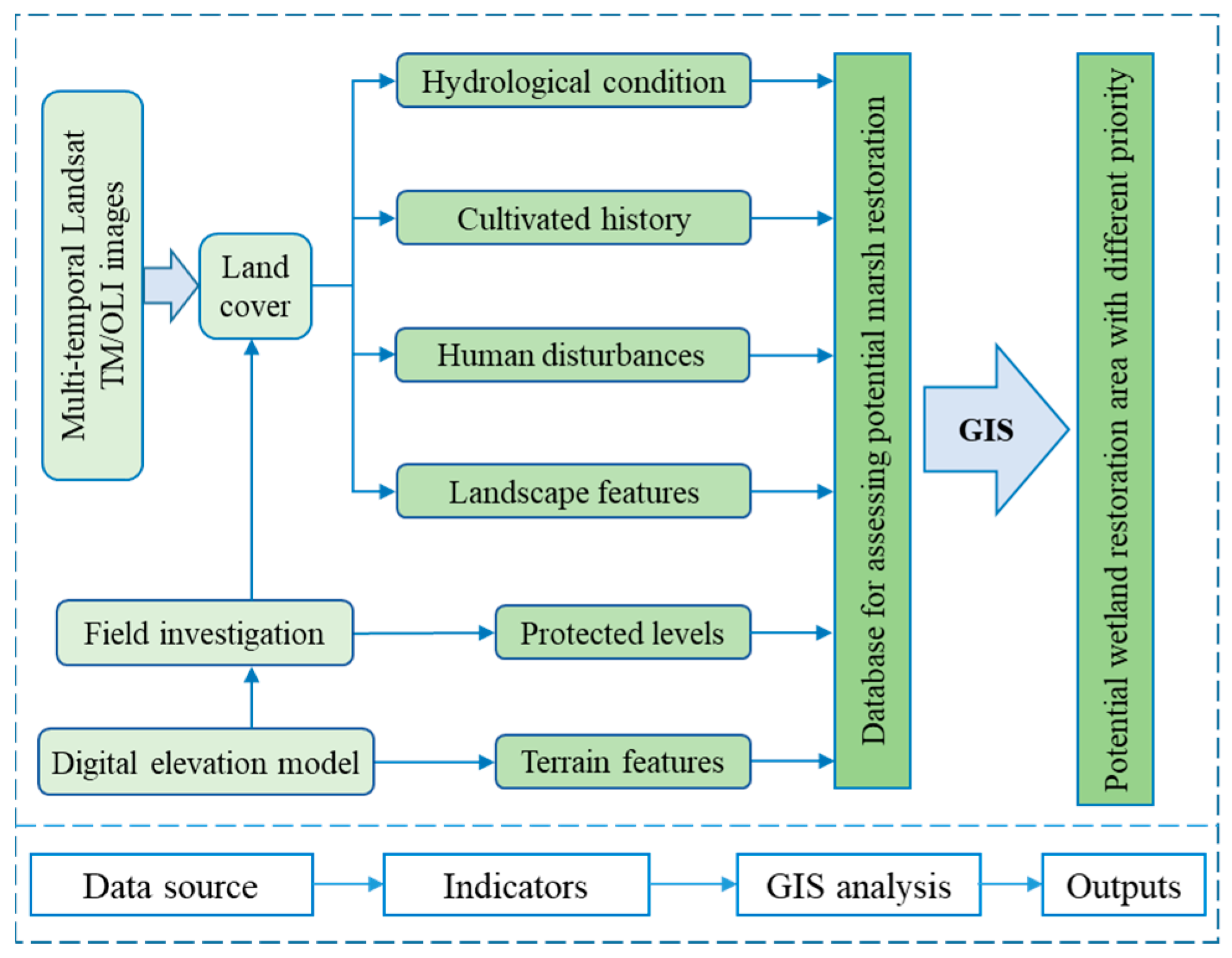
2.4. Approach for Identifying Potential Areas for Wetland Restoration

The potential areas for wetland restoration from cropland were identified by overlaying these six dataset layers using the ArcGIS 10.1 software. We focused on the regions with high and medium priorities for wetland restoration from croplands. First, the flooded croplands, croplands converted from wetlands during 1990–2015, and croplands in the protected areas were merged into a dataset layer. Second, the croplands meeting hydrological conditions were clipped from the dataset layer. Third, some croplands were excluded based on the terrain and human disturbance indicators. Fourth, the remaining croplands were separated into potential areas for wetland restoration with high and medium priorities, based on the stated criteria. Finally, we mapped and summarized the potential areas for wetland restoration from croplands. The GIS-based model for wetland restoration is described in Figure 2.

3. Results

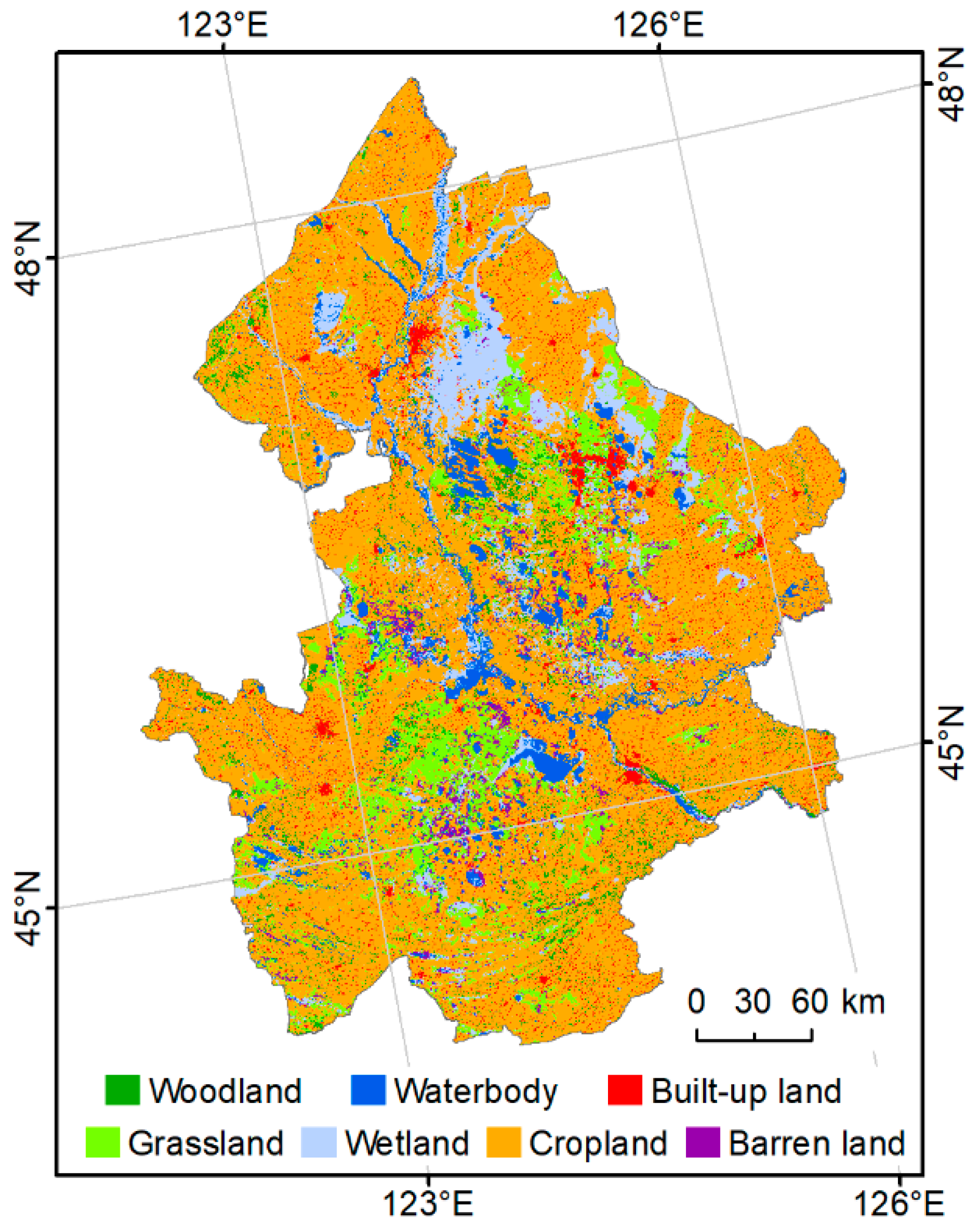
3.1. Landscape Pattern and Composition in 2015

Figure 3 documents the spatial pattern of landscape over the WSNP in 2015. Cropland is the dominant landscape type. The area of croplands in the WSNP was estimated to be 64,497.0 km2, accounting for 63.6% of the study area. Grasslands were extensively observed in the central part, and had the second largest area, 10,109.7 km2 or 10% of the WSNP. Wetlands and waterbodies totally covered 15% of the study area, were mostly identified in the northern part, and were estimated to be 9642.8 km2 and 5623.6 km2, respectively. The largest wetland patch, with an area of 2009.1 km2, was observed in the Zhalong Ramsar site. Small areas of woodlands (4151.3 km2) were observed in the WSNP. Built-up and barren lands were widely distributed in the study area, with a total area of 4935.7 (4.9%) and 2453.3 km2 (2.4%), respectively.

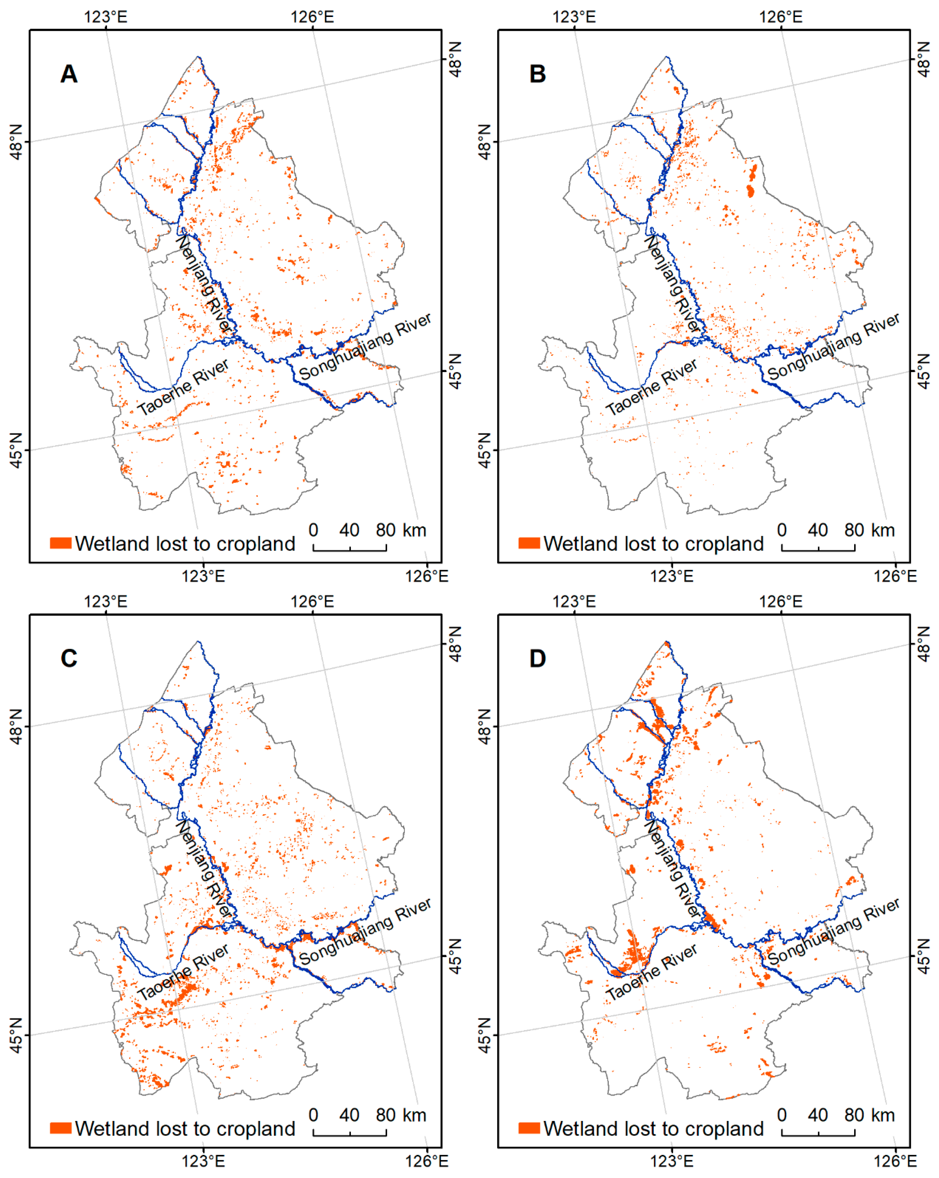
3.2. Wetlands Loss Encroached by Cropland Expansion

For determining the amount and location of historical wetlands lost to cropland expansion, the data layers of croplands and wetlands were overlaid. The intersected results revealed that extensive wetlands were converted into croplands during the observed four periods: 2010–2015, 2005–2010, 2000–2005, and 1990–2000 (Figure 4 and Table 2). Isolated and scattered wetlands were encroached upon by cropland expansion during the last two periods of 2010–2015 and 2005–2010, while the wetlands converted into croplands were dominant in southern WSNP during 2000–2005 and in northern WSNP during 1990–2000. Wetlands close to rivers were more likely to be cultivated.
From 1990 to 2015, there were a total of 2753.3 km2 of wetlands converted into croplands. The largest reclamation rate (130.5 km2·yr−1) was identified in the period 2000–2005, and a declined conversion from wetland to cropland was revealed during the past decade. Additionally, there was a decreasing ratio of cropland cultivation-induced wetland loss to the total wetland loss over the WSNP (Table 2). Cropland cultivation contributed to 74.2% of the wetland loss during the period 1990–2000, but only 23.5% during the period 2010–2015.

3.3. Spatial Explicit Information of Wetland Restoration Indicators

Understanding current hydrological conditions is required for making decisions for wetland restoration. Our analysis indicated good hydrological conditions due to extensive waterbodies in the WSNP, despite the semiarid climate that predominates in the study area (Figure 5A). An overlay between a buffer of 300 m from waterbody and cropland in 2015 revealed that 5923.2 km2 of croplands had good hydrological conditions for wetland restoration. In addition, satellite images documented that the two floods in the WSNP mapped in Figure 5B inundated a large area of land including croplands. Out results indicated that the flooded area in 1998 covered 9347.9 km2 of cropland in 2015, while that of 2013 covered 3583.6 km2.
A slope analysis indicated that 1090.2 km2 of croplands were located in areas with a slope value larger than 15°. These croplands were excluded from the potential areas for wetland restoration. Additionally, there were a total of 263.2 km2 of isolated croplands with an area smaller than 5 ha. Where they meet the stated above criteria, these isolated croplands were assigned to be with high priority for wetland restoration.
Obvious potential for human disturbances, especially from agricultural activities, were identified for the wetlands in the national wetland nature reserves. As shown in Table 3, there were still many croplands distributed in the core and buffer zones which should have been prohibited. Specifically, the Momoge nature reserve had the most croplands, with an area of 845.9 km2, accounting for 57.1% of the total area of reserve. The Dabusu nature reserve had the smallest area of cropland (32.6 km2), accounting for 29.2% of the total area. If they met the stated hydrological and terrain criteria, the croplands in these core and buffer zones of nature reserves were assigned as high priority for wetland restoration, while croplands in experimental zones were assigned medium priority.

3.4. Pattern in Potential Areas for Wetland Restoration

After the overlay analysis of these indicators for wetland restoration, the distribution of potential areas for restoration with different priorities were identified. As shown in Figure 6, the potential areas with high priority for restoration are mostly observed along the Nenjiang and Songhuajiang Rivers. Potential areas with medium priority for wetland restoration are mainly concentrated along the Nenjiang, Songhuajiang, and Taoerhe Rivers, and scattered in the southern WSNP.
Table 4 reports potential areas for wetland restoration from cropland with different priorities. As we estimated, 12,588.1 km2 of croplands are suitable for conversion to wetlands, of which 3706 km2 (29.4%) are of high priority, and 8882.1 km2 (70.6%) are of medium priority. There are 5597.4 km2 of dry farmlands identified as potential areas for wetland restoration, of which 46.2% (2586.4 km2) are of high priority. A total of 3284.7 km2 of paddy fields are identified as potential areas for wetland restoration, of which 1119.6 km2 are of high priority, and another 2165.1 km2 are of medium priority.

4. Discussion

4.1. Indicators for Wetland Restoration

China lost a large amount of wetland, which caused serious ecological consequences over the past decades [24,25,26,27,28,29,30,31,32,33,34]. The dominant factor driving China’s wetland loss has been identified as agricultural cultivation [21]. In response to wetland degradation and negative ecological consequences, China has made ambitious aims to restore more wetlands. Therefore, scientific spatial decisions are critical to achieving more wetland restoration from croplands. Identifying where croplands can be converted to wetlands is the primary and most important step.
Many publications have been made to investigate potential areas for wetland restoration. For example, O’Neill et al. [14] developed a conceptual model in terms of a wetness index to identify sites for riparian wetland restoration over the upper Arkansas River basin in United States. However, the wetness index is a topographically derived parameter, which is limited due to digital elevation model (DEM) resolution. A single index is inadequate to identify potential sites for wetland restoration. Furthermore, a wetness index and cropland productivity were integrated by Huang et al. [15] to identify potential sites for wetland restoration from croplands in China’s Sanjiang Plain. However, the net primary productivity (NPP) product used in their study should not be equal to grain production. Furthermore, these two studies have not considered the disturbance from human activities. White and Fennessy [35] designed a GIS-based model to simulate the suitability of wetland restoration potential at a watershed scale by selecting criteria from hydrological regime, vegetation and soil characters, topography, and so on. Hua et al. [16] also established an eco-hydrological approach to identify potential restoration areas. Both studies greatly improved the indicator system for wetland restoration suitability. The cultivation period of wetlands and wetland conservation levels, which are important to wetland restoration, were not used as indicators for wetland restoration with different priorities. Therefore, a comprehensive indictor system is necessary for wetland restoration. Soil drainage has been considered by Horvath et al. [13] to identify potential areas for restoration. In our study area, we argue that all croplands are suitable from the perspective of soil property.
In this study, six indicators were integrated to identify the potential areas for converting cropland into wetland. Wetlands play an important role in flood abatement; however, WSNP still experienced serious flood disasters in the past decades. Therefore, it is important to categorize the flooded cropland as potential areas for wetland restoration with priority. Previous studies also highlighted the importance of time under cultivation in converting croplands into wetlands in terms of maximizing the effectiveness of the soil seed bank [18,36]. Besides the hydrological and terrain conditions and landscape features, we incorporated the flooded area, cultivation period of wetlands, human disturbance, and wetland protection into the criteria. In our opinion, multiple indicators largely improved the feasibility in identifying the potential areas for performing wetland restoration in the WSNP.

4.2. Advantages of RS and GIS in Supporting Wetland Restoration

The advantages of RS and GIS in wetland ecosystem management have been confirmed in previous studies. For example, large numbers of studies have been conducted based on RS and GIS to investigate the conversions between wetland and cropland [21,25]. RS provides important data, covering a broad spatial extent and a long time series, while GIS has been widely used to develop data analysis and mapping [23,37]. Making spatial decisions is critical to wetland restoration at a regional scale [13]. In this study, we quantitatively documented the potential areas for converting cropland to wetland by integrating RS and GIS technologies. Landsat images provide a critical data source for examination of conversions from wetland to cropland during historical periods, investigations the flooded extent, discrimination among the hydrological conditions, and identification of human disturbance. GIS provides an important approach to achieving buffer and overlay analyses. The object-oriented image classification method played an important role in obtaining the land cover for the WSNP, and has been proven to be more accurate and robust than the traditional, pixel-based method [38]. Compared to analyses on raster data, the present study carried out analyses directly on the vector data, which minimized the error from raster data analyses due to coarse resolution.
It was estimated that global wetlands lost more than 50% of their area during the past decades [4,5]. In China, 15,765 km2 of wetlands were lost to cropland expansion during 1990–2010, but only 1369 km2 were returned based on the RS and GIS [21]. Therefore, identifying potential areas for restoring wetlands on a national scale is necessary, based on both RS and GIS. The method used in this study can provide effective examples for achieving such identification, because all the input data could be obtained for the whole country. However, Landsat images with a spatial resolution of 30 m were used to classify the land cover in this study, which may limit the ability to identify the contribution of streams in wetland restoration. Although indicators of flooded areas minimized this effect, high-resolution images are necessary for planning wetland restoration on a small scale and for future studies. New technology, such as unmanned aerial vehicles, is available for rapidly acquiring the current features of the land surface [39].

4.3. Management Implications for Regional Sustainability

In this study, we focused on wetland restoration only from cropland. It is necessary to balance the demand between food production and ecological conservation [40,41]. Scientific wetland restoration is beneficial for addressing ecological issues in the WSNP. Meanwhile, in response to regional ecological security and the pressure of agriculture on water resources, WSNP must develop sustainable plans to stop additional cropland expansion. Although WSNP is located in a semiarid zone of China, WSNP is one of the three important lake-distributed areas in the country [42]. Reducing flood disaster and making efficient use of flood water are important to regional ecosystem management and sustainable development. Restoring additional wetlands, especially along rivers, is the key to addressing this ecological problem. WSNP should return more wetlands from croplands instead of constructing more dams. As noted, large areas of croplands still exist in nature reserves, even in the core and buffer zones of the Ramsar sites. Agricultural activities imposed remarkable threats to the wetland ecosystem and caused negative consequences, including decreased wildlife habitat suitability, polluted water, and other weakened ecosystem services [10,21]. Therefore, managers should pay additional attention to the return of croplands to natural ecosystems in order to improve the ecological effectiveness of nature reserves. Before anthropogenic restoration, abandoning cultivation on croplands with restoration priority is the first important step. Local governments should play more dominant roles in this process, such as providing grain subsidies to those that participate in restoration activities, and creating more employment for farmers.
Although we estimated that 3706 km2 of croplands were of high priority for restoration to wetlands, and 5176.1 km2 were of medium priority, the final implementation of wetland restoration projects may need to consider additional factors, such as cost, land ownership, etc. Combing our map, field investigation is still necessary for designing specific wetland restoration projects. Besides scientific planning for restoring wetlands in suitable regions, effective implementation of wetland restoration should also require more integrated knowledge related to wetland ecosystem functions and services [43]. Except for recognizing where wetlands can be reconstructed, we should maximize the function and service of the restored wetland ecosystem. For example, most of the restored wetlands in the flooded area are expected to regulate floods, conserve water resources, and provide more wildlife habitats. The restored wetlands in the nature reserves are primarily expected to protect biodiversity and improve carbon sequestration. Restored wetlands in areas that serve as drinking water sources could contribute to purifying and protecting water quality. Additionally, wetland creation may be needed in specific regions for protecting or repairing the environment, which should be fully studied in future. Therefore, place-based strategies and implementation plans for wetland restoration and creation are still needed. Additionally, RS and GIS should also be used to assess the effectiveness of wetland restoration and creation projects [44].

5. Conclusions

The integration of RS data and GIS analysis has enabled the investigation of potential for the conversion of croplands into wetlands. We identified the landscape patterns in WSNP, and the wetlands cultivated into croplands during the different periods from 1990 to 2015. Furthermore, besides the current hydrological, topographical, and landscape features, flooded area, time under cultivation, human disturbance, and wetland conservation levels were selected to identify the potential areas for wetland restoration from croplands with different priorities. Results revealed that a total of 2753.3 km2 of wetlands were cultivated into cropland for grain production from 1990 to 2015. Additionally, 8882.1 km2 of croplands are suitable for conversion to wetlands, of which 3706 km2 (29.4%) are of high priority. Our study documents that the combination of RS and GIS is a quick and effective approach to identifying potential areas for wetland restoration from croplands. The method used in our study could provide a reference for the identification of potential areas for the conversion of cropland to wetland in other regions. The map of potential areas for wetland restoration from croplands generated in this study is also expected to help decision makers to implement wetland restoration in the WSNP.

Author Contributions

L.L., D.M. and Z.W. conceived the study. L.L., B.D. and H.Y. generated the datasets. L.L. and D.M. performed the data analysis and prepared the manuscript. Z.W. and B.Z. provided critical feedback and edited the manuscript.

Funding

This research was jointly supported by the Strategic Planning Project of the Institute of Northeast Geography and Agroecology, Chinese Academy of Sciences [IGA-135-05], National Key Research and Development Program of China [2016YFC0500408 and 2016YFC0500201], National Natural Science Foundation of China [41771383], the funding from Youth Innovation Promotion Association Chinese Academy of Sciences [2017277 and 2012178], and the Outstanding Young Scientist Foundation of Northeast Institute of Geography and Agroecology, Chinese Academy of Sciences [Y5h1061001].

Acknowledgments

We are very grateful to those who participated in the image classification and field investigation to produce the land cover.

Conflicts of Interest

The authors declare no conflict of interest.

References

  1. Millennium Ecosystem Assessment. Ecosystems and Human Well-Being: Wetlands and Water; World Resources Institute: Washington, DC, USA, 2005; p. 1. [Google Scholar]
  2. Cao, L.; Fox, A.D. Birds and people both depend on China’s wetlands. Nature 2009, 460, 173. [Google Scholar] [CrossRef] [PubMed]
  3. Asselen, S.; Verburg, P.H.; Vermaat, J.E.; Janse, J.H. Drivers of wetland conversion: A global meta-analysis. PLoS ONE 2013, 8, e81292. [Google Scholar] [CrossRef] [PubMed]
  4. Hu, S.; Niu, Z.; Chen, Y.; Li, L.; Zhang, H. Global wetlands: Potential distribution, wetland loss, and status. Sci. Total Environ. 2017, 586, 319–327. [Google Scholar] [CrossRef] [PubMed]
  5. Rebelo, L.M.; Finlayson, C.M.; Nagabhatla, N. Remote sensing and GIS for wetland inventory, mapping and change analysis. J. Environ. Manag. 2009, 90, 2144–2153. [Google Scholar] [CrossRef] [PubMed]
  6. Nicholls, R.J. Coastal flooding and wetland loss in the 21st century: Changes under the SRES climate and socio-economic scenarios. Glob. Environ. Chang. 2004, 14, 69–86. [Google Scholar] [CrossRef]
  7. Ma, Z.; Melville, D.S.; Liu, J.G.; Chen, Y.; Yang, Y.; Ren, W.; Zhang, Z.; Piersma, T.; Li, B. Rethinking China’s new great wall. Science 2014, 346, 912–914. [Google Scholar] [CrossRef] [PubMed]
  8. Yang, H.; Ma, M.; Thompson, J.R.; Flower, R.J. Protecting coastal wetlands in China to save endangered migratory birds. PNAS 2017, 114, 5491–5492. [Google Scholar] [CrossRef] [PubMed]
  9. Zedler, J.B. Wetlands at your service: Reducing impacts of agriculture at the watershed scale. Front. Ecol. Environ. 2003, 1, 65–72. [Google Scholar] [CrossRef]
  10. Song, K.; Wang, Z.; Du, J.; Liu, L.; Zeng, L.; Ren, C. Wetland degradation: Its driving forces and environmental impacts in the Sanjiang Plain, China. Environ. Manag. 2014, 54, 255–271. [Google Scholar] [CrossRef] [PubMed]
  11. Man, W.; Yu, H.; Li, L.; Liu, M.; Mao, D.; Ren, C.; Wang, Z.; Jia, M.; Miao, Z.; Lu, C.; et al. Spatial expansion and soil organic carbon storage changes of croplands in the Sanjiang Plain, China. Sustainability 2017, 9, 563. [Google Scholar] [CrossRef]
  12. Erwin, K.L. Wetlands and global climate change: The role of wetland restoration in a changing world. Wetl. Ecol. Manag. 2009, 17, 71–84. [Google Scholar] [CrossRef]
  13. Horvath, E.K.; Christensen, J.R.; Mehaffey, M.H.; Neale, A.C. Building a potential wetland restoration indicator for the contiguous United States. Ecol. Indic. 2017, 83, 463–473. [Google Scholar] [CrossRef] [PubMed]
  14. O’Neill, M.P.; Schmidt, J.C.; Dobrowolski, J.P.; Hawkins, C.P.; Neale, C.M.U. Identifying sites for riparian wetland restoration: Application of a model to the upper Arkansas River Basin. Restor. Ecol. 1997, 5, 85–102. [Google Scholar] [CrossRef]
  15. Huang, N.; Wang, Z.; Liu, D.; Niu, Z. Selecting sites for converting farmlands to wetlands in the Sanjiang Plain, Northeast China, based on remote sensing and GIS. Environ. Manag. 2010, 46, 790–800. [Google Scholar] [CrossRef] [PubMed]
  16. Hua, Y.; Cui, B.; He, W.; Cai, Y. Identifying potential restoration areas of freshwater wetlands in a river delta. Ecol. Indic. 2016, 71, 438–448. [Google Scholar] [CrossRef]
  17. Stroh, P.A.; Hughes, F.M.R.; Sparks, T.H.; Mountford, J.O. The influence of time on the soil seed bank and vegetation across a landscape-scale wetland restoration project. Restor. Ecol. 2012, 20, 103–112. [Google Scholar] [CrossRef]
  18. Wang, G.; Wang, M.; Lu, X.; Jiang, M. Effects of farming on the soil seed banks and wetland restoration potential in Sanjiang Plain, Northeastern China. Ecol. Eng. 2015, 77, 265–274. [Google Scholar] [CrossRef]
  19. Ballanti, L.; Byrd, K.B.; Woo, I.; Ellings, C. Remote sensing for wetland mapping and historical change detection at the Nisqually River Delta. Sustainability 2017, 9, 1919. [Google Scholar] [CrossRef]
  20. Klemas, V. Using remote sensing to select and monitor wetland restoration sites: An overview. J. Coast. Res. 2013, 29, 958–970. [Google Scholar] [CrossRef]
  21. Mao, D.; Luo, L.; Wang, Z.; Wilson, M.C.; Zeng, Y.; Wu, B.; Wu, J. Conversion between natural wetlands and farmland in China: A multiscale geospatial analysis. Sci. Total Environ. 2018, 634, 550–560. [Google Scholar] [CrossRef] [PubMed]
  22. Wang, Z.; Wu, J.; Madden, M.; Mao, D. China’s wetlands: Conservation plans and policy impacts. AMBIO 2012, 41, 782–786. [Google Scholar] [CrossRef] [PubMed]
  23. Dong, Z.; Wang, Z.; Liu, D.; Li, L.; Ren, C.; Tang, X.; Jia, M.; Liu, C. Assessment of habitat suitability for waterbirds in the West Songnen Plain, China, using remote sensing and GIS. Ecol. Eng. 2013, 55, 94–100. [Google Scholar] [CrossRef]
  24. Mao, D.; Wang, Z.; Wu, J.; Wu, B.; Zeng, Y.; Song, K.; Yi, K.; Luo, L. China’s wetlands loss to urban expansion. Land Degrad. Dev. Available online: https://onlinelibrary.wiley.com/doi/abs/10.1002/ldr.2939?af=R& (accessed on 4 July 2018).
  25. Wang, Z.; Huang, N.; Luo, L.; Li, X.; Ren, C.; Song, K.; Chen, J. Shrinkage and fragmentation of marshes in the West Songnen Plain, China, from 1954 to 2008 and its possible causes. Int. J. Appl. Earth Obs. 2011, 13, 477–486. [Google Scholar] [CrossRef]
  26. Wang, Z.; Song, K.; Zhang, B.; Liu, D.; Ren, C.; Luo, L.; Yang, T.; Huang, N.; Hu, L.; Yang, H.; et al. Shrinkage and fragmentation of grasslands in the West Songnen Plain, China. Agric. Ecosyst. Environ. 2009, 129, 315–324. [Google Scholar] [CrossRef]
  27. Wu, B.; Yuan, Q.; Yan, C.; Wang, Z.; Yu, X.; Li, A.; Ma, R.; Huang, J.; Chen, J.; Chang, C.; et al. Land cover changes of China from 2000 to 2010. Quat. Sci. 2014, 34, 723–731. (In Chinese) [Google Scholar]
  28. Zhang, L.; Li, X.; Yuan, Q.; Liu, Y. Object-based approach to national land cover mapping using HJ satellite imagery. J. Appl. Remote Sens. 2014, 8, 083686. [Google Scholar] [CrossRef]
  29. Ouyang, Z.; Zheng, H.; Xiao, Y.; Polasky, S.; Liu, J.; Xu, W.; Wang, Q.; Zhang, L.; Xiao, Y.; Rao, E.; et al. Improvements in ecosystem services from investigates in natural capital. Science 2016, 352, 1455–1459. [Google Scholar] [CrossRef] [PubMed]
  30. Tian, Y.; Luo, L.; Mao, D.; Wang, Z.; Li, L.; Liang, J. Using landsat images to quantify different human threats to the Shuangtai Estuary Ramsar site, China. Ocean Coast. Manag. 2017, 135, 56–64. [Google Scholar] [CrossRef]
  31. Lu, C.; Wang, Z.; Li, L.; Wu, P.; Mao, D.; Jia, M.; Dong, Z. Assessing the conservation effectiveness of wetland protected areas in Northeast China. Wetl. Ecol. Manag. 2016, 24, 381–398. [Google Scholar] [CrossRef]
  32. Zheng, Y.; Zhang, H.; Niu, Z.; Gong, P. Protection efficacy of national wetland reserves in China. Chin. Sci. Bull. 2012, 57, 1116–1134. [Google Scholar] [CrossRef]
  33. Gong, P.; Niu, Z.; Cheng, X.; Zhao, K.; Zhou, D.; Guo, J.; Liang, L.; Wang, X.; Li, D.; Huang, H.; et al. China’s wetland change (1990–2000) determined by remote sensing. Sci. China Earth Sci. 2010, 53, 1036–1042. [Google Scholar] [CrossRef] [Green Version]
  34. Niu, Z.; Zhang, H.; Wang, X.; Yao, W.; Zhou, D.; Zhao, K.; Zhao, H.; Li, N.; Huang, H.; Li, C.; et al. Mapping wetland changes in China between 1978 and 2008. Chin. Sci. Bull. 2012, 57, 2813–2823. [Google Scholar] [CrossRef] [Green Version]
  35. White, D.; Fennessy, S. Modelling the suitability of wetland restoration potential at the watershed scale. Ecol. Eng. 2005, 24, 359–377. [Google Scholar] [CrossRef]
  36. Middleton, B.A. Soil seed banks and the potential restoration of forested wetlands after farming. J. Appl. Ecol. 2003, 40, 1025–1034. [Google Scholar] [CrossRef] [Green Version]
  37. Stein, E.D.; Dark, S.; Longcore, T.; Grossinger, R.; Hall, N.; Beland, M. Historical ecology as a tool for assessing landscape change and informing wetland restoration priorities. Wetlands 2010, 30, 589–601. [Google Scholar] [CrossRef]
  38. Wang, Z.; Mao, D.; Li, L.; Jia, M.; Dong, Z.; Miao, Z.; Ren, C.; Song, C. Quantifying changes in multiple ecosystem services during 1992–2012 in the Sanjiang Plain of China. Sci. Total Environ. 2015, 514, 119–130. [Google Scholar] [CrossRef] [PubMed]
  39. Klemas, V.V. Coastal and environmental remote sensing from unmanned aerial vehicles: An overview. J. Coast. Res. 2015, 31, 1260–1267. [Google Scholar] [CrossRef]
  40. Dalin, C.; Qiu, H.; Hanasaki, N.; Mauzerall, D.L.; Rodriguez-Iturbe, I. Balancing water resource conservation and food security in China. PNAS 2015, 112, 4588–4593. [Google Scholar] [CrossRef] [PubMed] [Green Version]
  41. Lu, Y.; Jenkins, A.; Ferrier, R.C.; Bailey, M.; Gordon, I.J.; Song, S.; Huang, J.; Jia, S.; Zhang, F.; Liu, X.; et al. Addressing China’s grand challenge of achieving food security while ensuring environmental sustainability. Sci. Adv. 2016, 1, e1400039. [Google Scholar] [CrossRef] [PubMed] [Green Version]
  42. Ma, R.; Yang, G.; Duan, H.; Jiang, J.; Wang, S.; Feng, X.; Li, A.; Kong, F.; Xue, B.; Wu, J.; et al. China’s lakes at present: Number, area and spatial distribution. Sci. China: Earth Sci. 2011, 54, 283–289. [Google Scholar] [CrossRef]
  43. Ma, Z.; Cai, Y.; Li, B.; Chen, J. Managing wetland habitats for waterbirds: An international perspective. Wetlands 2010, 30, 15–27. [Google Scholar] [CrossRef]
  44. Cui, B.; Yang, Q.; Yang, Z.; Zhang, K. Evaluating the ecological performance of wetland restoration in the Yellow River Delta, China. Ecol. Eng. 2009, 35, 1090–1103. [Google Scholar] [CrossRef]
Figure 1. Geographic situation of the West Songnen Plain.
Sustainability 10 02375 g001
Figure 2. Frame model for identifying potential areas for wetland restoration.
Sustainability 10 02375 g002
Figure 3. Spatial distribution and composition of land cover in 2015.
Sustainability 10 02375 g003
Figure 4. Distribution of wetlands lost to croplands in West Songnen Plain: (A) 2010–2015; (B) 2005–2010; (C) 2000–2005; (D) 1990–2000.
Sustainability 10 02375 g004
Figure 5. Spatial pattern of indicators for wetland restoration: (A) hydrological condition in 2015; (B) flooded area in 1998 and 2013; (C) land slope; (D) human disturbance; (E) isolated cropland; (F) protected area.
Sustainability 10 02375 g005
Figure 6. Spatial pattern of potential areas for wetland restoration from cropland.
Sustainability 10 02375 g006
Table 1. Land cover categories in West Songnen Plain and image features.
CategoryDescriptionImage ExamplePhoto Example
WoodlandWoody vegetation Sustainability 10 02375 i001 Sustainability 10 02375 i002
GrasslandHerbaceous vegetation with dry soil Sustainability 10 02375 i003 Sustainability 10 02375 i004
WetlandHerbaceous vegetation with water saturation in soil Sustainability 10 02375 i005 Sustainability 10 02375 i006
WaterbodyOpen surface water Sustainability 10 02375 i007 Sustainability 10 02375 i008
CroplandArtificial vegetation with obvious phenology, harvested Sustainability 10 02375 i009 Sustainability 10 02375 i010
Built-up landArtificial bare surface Sustainability 10 02375 i011 Sustainability 10 02375 i012
Bare landNatural bare surface Sustainability 10 02375 i013 Sustainability 10 02375 i014
Table 2. Wetland loss to cropland during different periods.
Wetlands Lost to Crop Cultivation2010–20152005–20102000–20051990–2000
Area (km2)444.3541.5652.51115.0
Contribution of crop cultivation in wetland loss (%)23.527.132.674.2
Table 3. Cropland area in the national wetland nature reserves.
Reserve NameCore Zone (km2)Buffer Zone (km2)Experimental Zone (km2)Total
Zhalong45.280.2225.1350.5
Xianghai129.556.5288.5474.5
Momoge259.8292.5293.6845.9
Chaganhu6.518.438.863.7
Dabusu0.67.124.932.6
Total441.6454.7870.91767.2
Table 4. Area in potential areas for wetland restoration from cropland with different priorities.
Area (km2)High PriorityMedium PriorityTotal
Dry farmland2586.43706.03011.05176.15597.48882.1
Paddy field1119.62165.13284.7

