Understanding the Spatial Structure of Urban Commuting Using Mobile Phone Location Data: A Case Study of Shenzhen, China


Abstract
:
1. Introduction
2. Study Area and Dataset
3. Methodology
3.1. Extracting the Home and Work Location
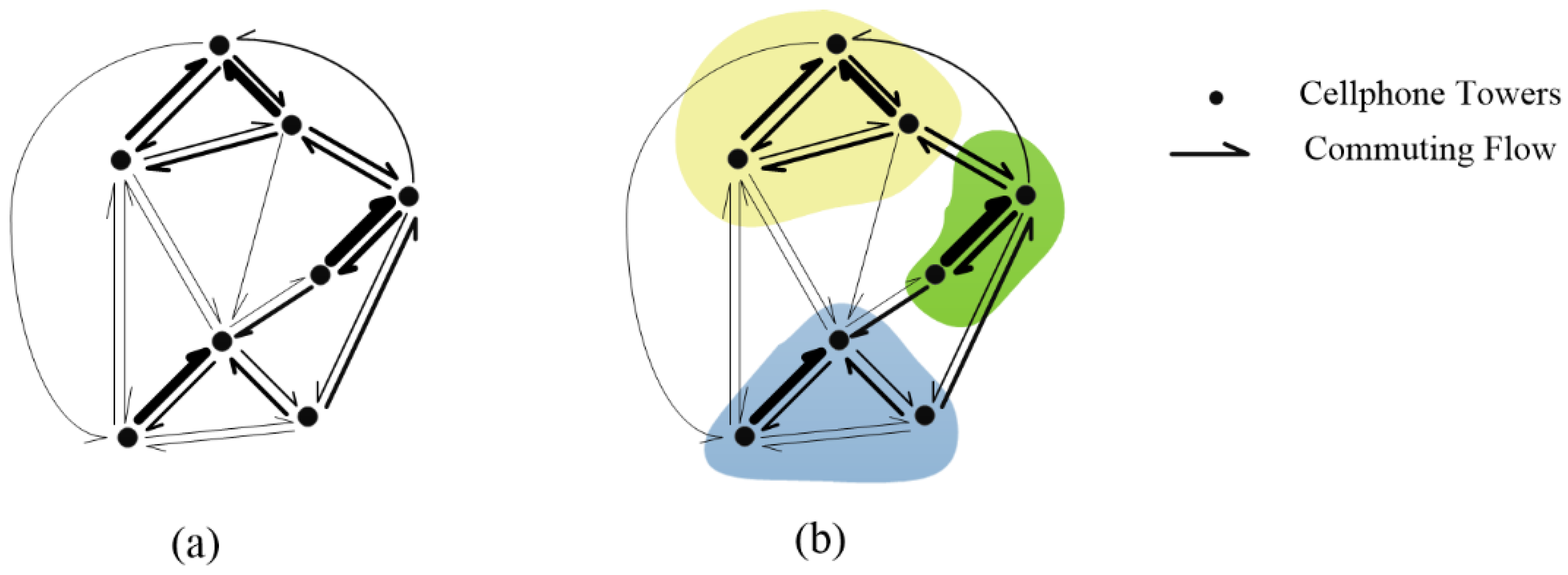
3.2. Detecting the Commuting Communities
3.3. Identifying Commuting Convergence and Divergence Areas for Each Community
4. Results and Discussion
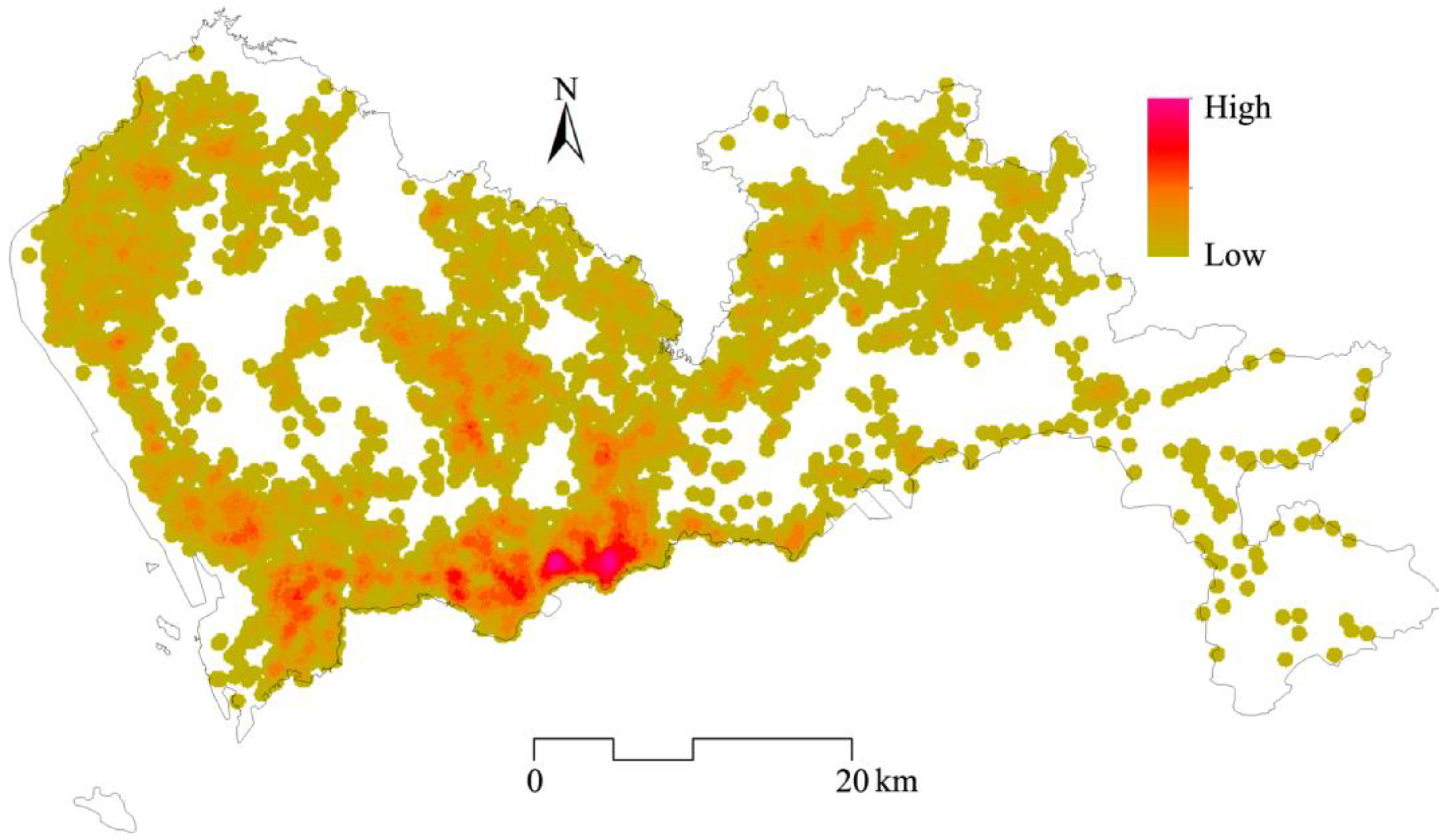
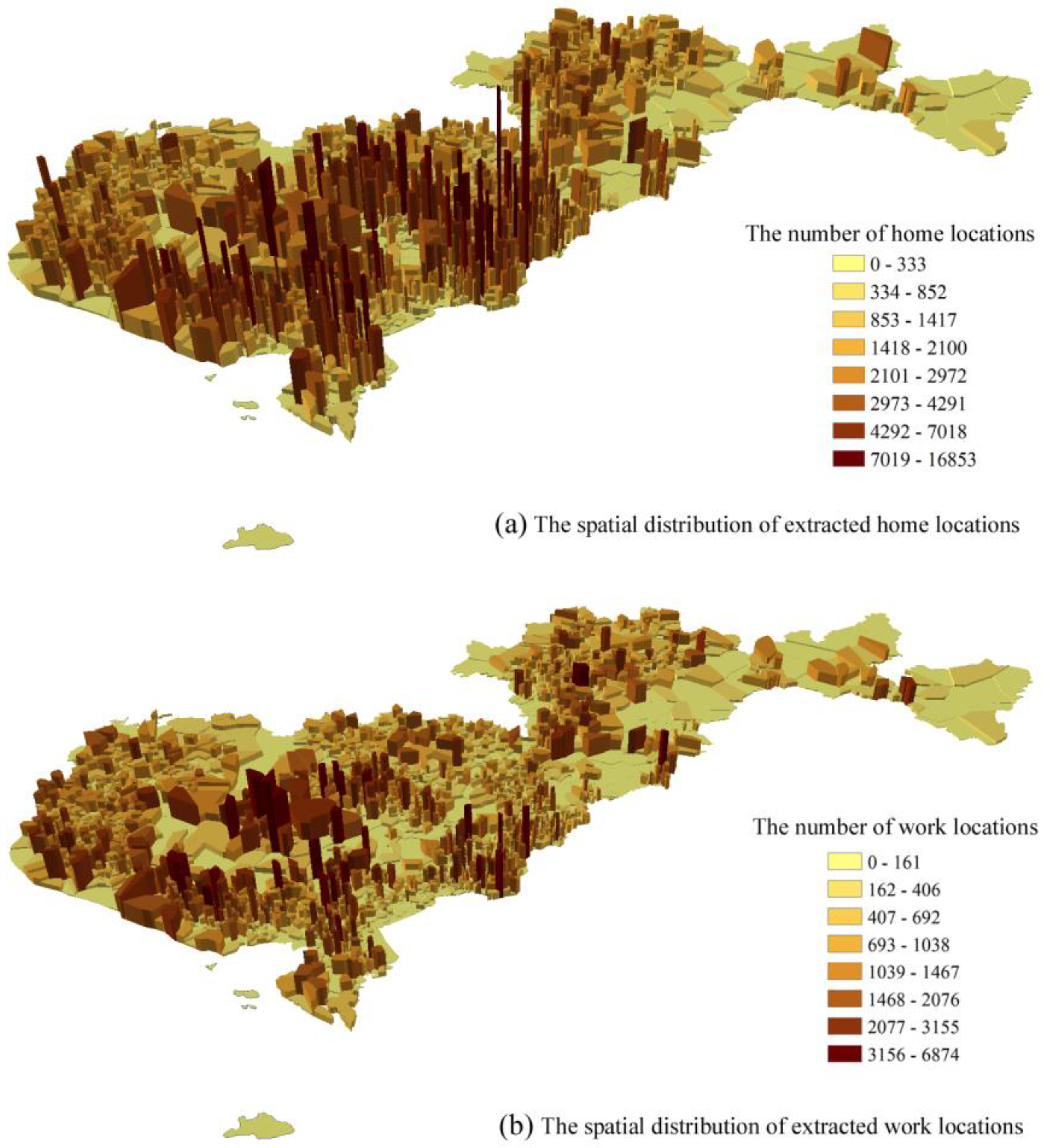
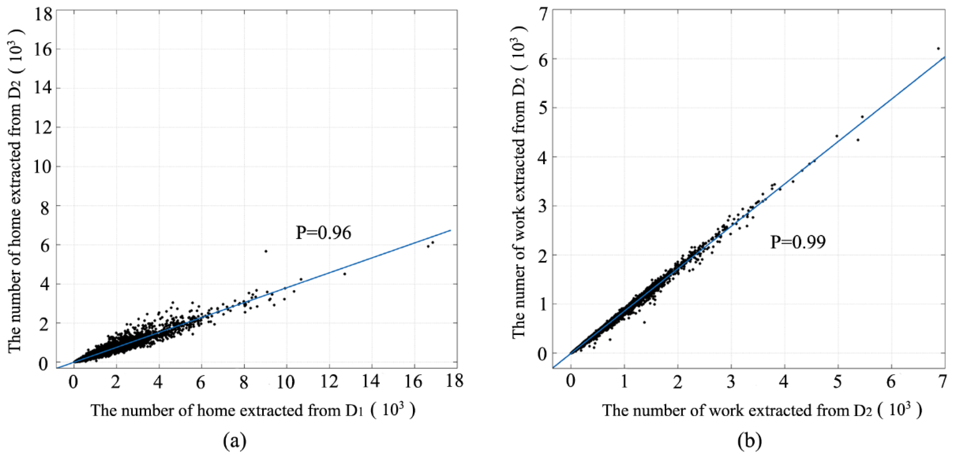
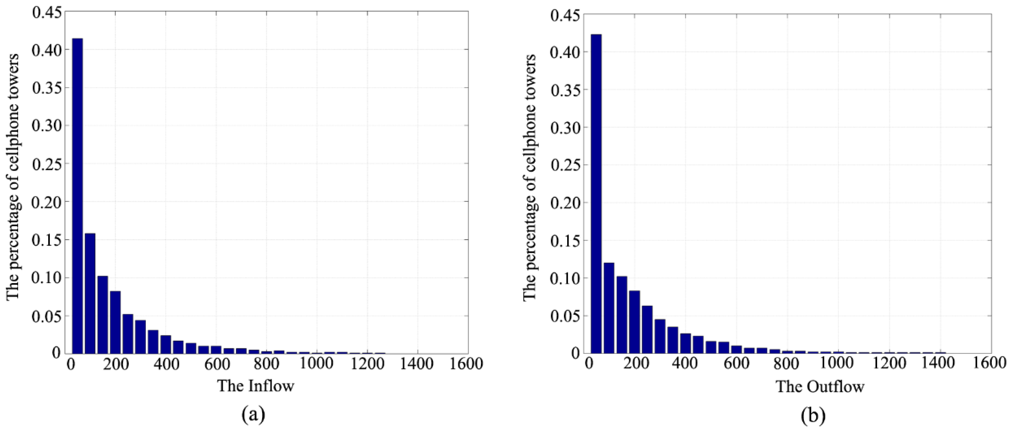
4.1. Extraction of Home and Work Locations
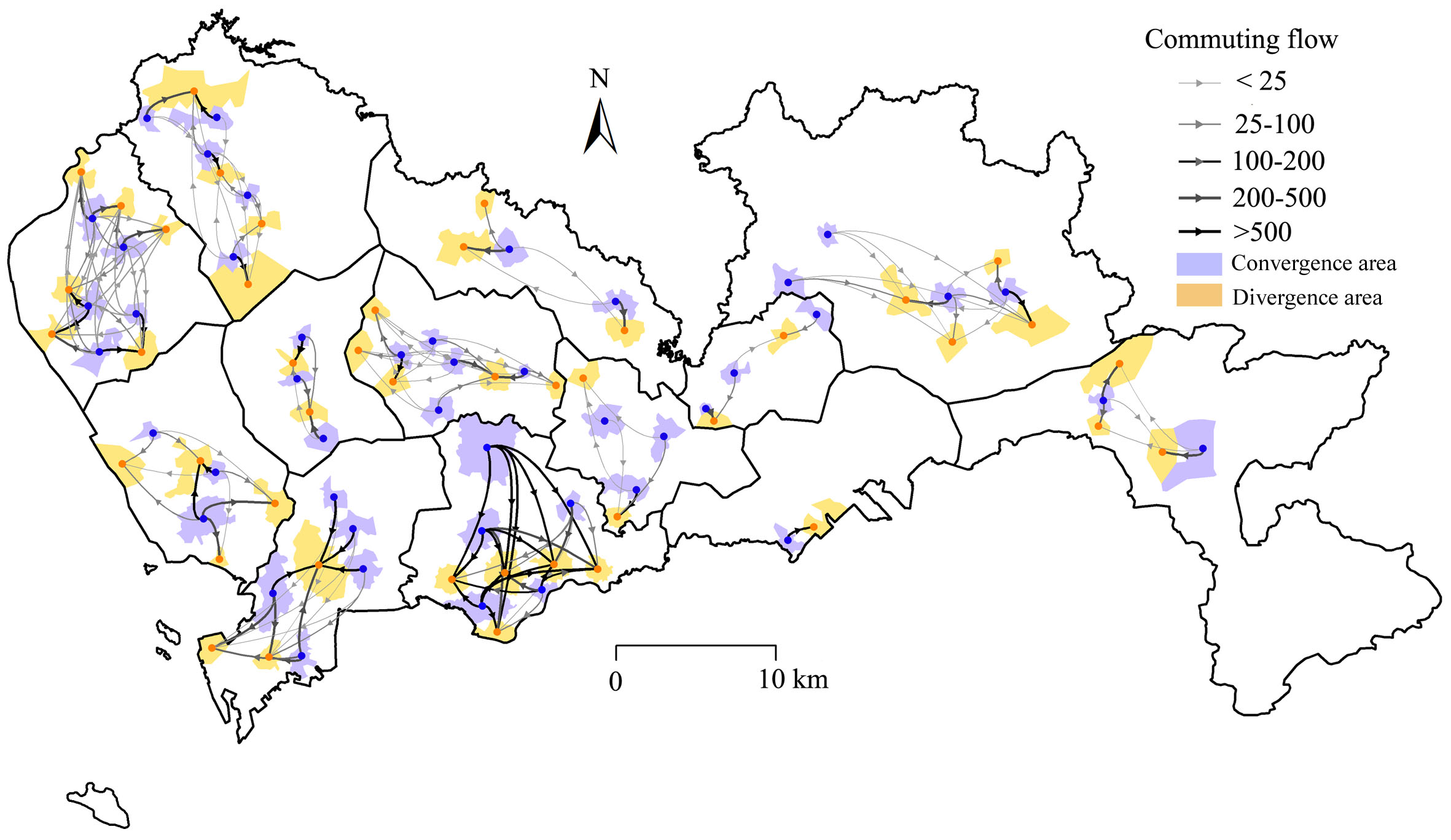
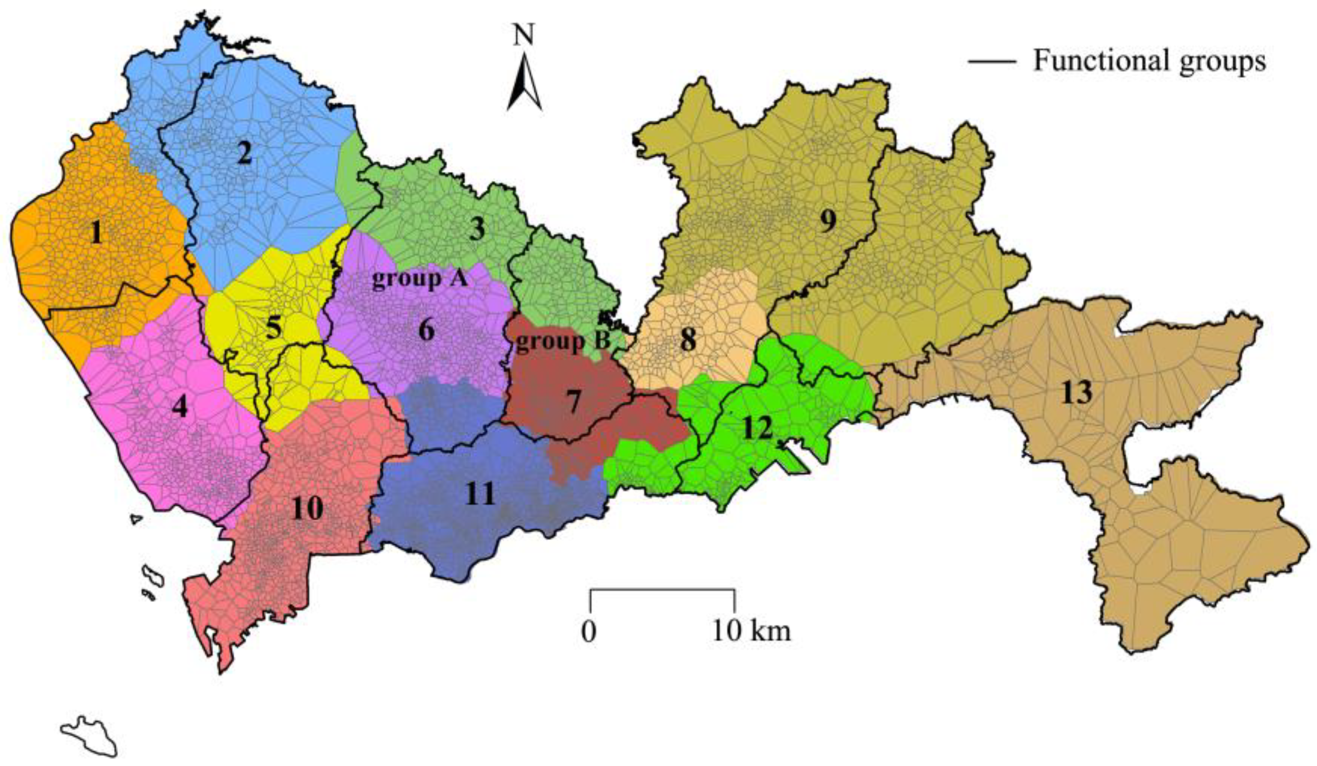
4.2. The Communities Detected Based on Commuting Flows
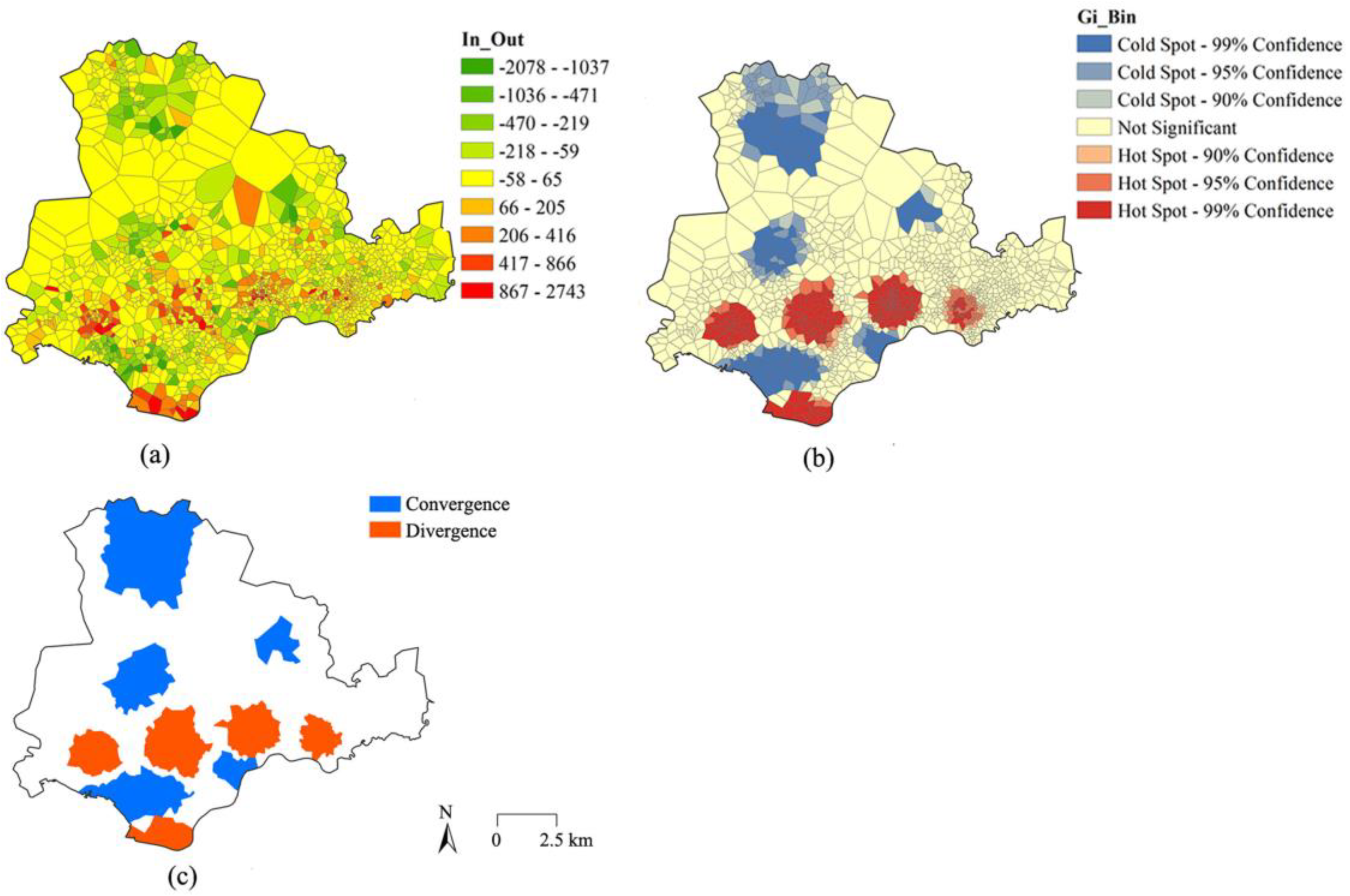
4.3. The Commuting Convergent and Divergent Areas for Each Community
5. Conclusions
Author Contributions
Acknowledgments
Conflicts of Interest
References
- Sohn, J. Are commuting patterns a good indicator of urban spatial structure? J. Transp. Geogr. 2005, 13, 306–317. [Google Scholar] [CrossRef]
- Ta, N.; Chai, Y.; Zhang, Y.; Sun, D. Understanding job-housing relationship and commuting pattern in chinese cities: Past, present and future. Transp. Res. Part D Transp. Environ. 2017, 52, 562–573. [Google Scholar] [CrossRef]
- Martin, R.W. Spatial mismatch and costly suburban commutes: Can commuting subsidies help? Urban Stud. 2001, 38, 1305–1318. [Google Scholar] [CrossRef]
- Koppelman, F.S.; Bhat, C.R.; Schofer, J.L. Market research evaluation of actions to reduce suburban traffic congestion: Commuter travel behavior and response to demand reduction actions. Transp. Res. Part A Policy Pract. 1993, 27, 383–393. [Google Scholar] [CrossRef]
- Modarres, A. Commuting and energy consumption: Toward an equitable transportation policy. J. Transp. Geogr. 2013, 33, 240–249. [Google Scholar] [CrossRef]
- Karanasiou, A.; Viana, M.; Querol, X.; Moreno, T.; de Leeuw, F. Assessment of personal exposure to particulate air pollution during commuting in european cities—Recommendations and policy implications. Sci. Total Environ. 2014, 490, 785–797. [Google Scholar] [CrossRef] [PubMed]
- Li, H.C.; Chiueh, P.T.; Liu, S.P.; Huang, Y.Y. Assessment of different route choice on commuters’ exposure to air pollution in Taipei, Taiwan. Environ. Sci. Pollut. Res. Int. 2017, 24, 3163–3171. [Google Scholar] [CrossRef] [PubMed]
- Zhu, J.; Fan, Y. Commute happiness in Xi’an, China: Effects of commute mode, duration, and frequency. Travel Behav. Soc. 2018, 11, 43–51. [Google Scholar] [CrossRef]
- McLafferty, S. Gender, race, and the determinants of commuting: New york in 1990. Urban Geogr. 1997, 18, 192–212. [Google Scholar] [CrossRef]
- Sang, S.; O’Kelly, M.; Kwan, M.P. Examining commuting patterns: Results from a journey-to-work model disaggregated by gender and occupation. Urban Stud. 2011, 48, 891–909. [Google Scholar] [CrossRef]
- Na, T.; Zhao, Y.; Chai, Y. Built environment, peak hours and route choice efficiency: An investigation of commuting efficiency using gps data. J. Transp. Geogr. 2016, 57, 161–170. [Google Scholar]
- Dai, D.; Zhou, C.; Ye, C. Spatial-temporal characteristics and factors influencing commuting activities of middle-class residents in Guangzhou city, China. Chin. Geogr. Sci. 2016, 26, 410–428. [Google Scholar] [CrossRef]
- Wang, D.; Chai, Y. The jobs–housing relationship and commuting in Beijing, China: The legacy of Danwei. J. Transp. Geogr. 2009, 17, 30–38. [Google Scholar] [CrossRef]
- Han, H.; Yang, C.; Wang, E.; Song, J.; Zhang, M. Evolution of jobs-housing spatial relationship in Beijing metropolitan area: A job accessibility perspective. Chin. Geogr. Sci. 2015, 25, 375–388. [Google Scholar] [CrossRef]
- Song, Y.; Shao, G.; Song, X.; Liu, Y.; Pan, L.; Ye, H. The relationships between urban form and urban commuting: An empirical study in China. Sustainability 2017, 9, 1150. [Google Scholar] [CrossRef]
- Martin, D.; Gale, C.; Cockings, S.; Harfoot, A. Origin-destination geodemographics for analysis of travel to work flows. Comput. Environ. Urban Syst. 2018, 67, 68–79. [Google Scholar] [CrossRef]
- Yuan, Y.; Raubal, M. Extracting Dynamic Urban Mobility Patterns from Mobile Phone Data; Springer: Berlin/Heidelberg, Germany, 2012; pp. 354–367. [Google Scholar]
- Yue, Y.; Lan, T.; Yeh, A.G.; Li, Q.-Q. Zooming into individuals to understand the collective: A review of trajectory-based travel behaviour studies. Travel Behav. Soc. 2014, 1, 69–78. [Google Scholar] [CrossRef]
- Liu, Y.; Liu, X.; Gao, S.; Gong, L.; Kang, C.; Zhi, Y.; Chi, G.; Shi, L. Social sensing: A new approach to understanding our socioeconomic environments. Ann. Assoc. Am. Geogr. 2015, 105, 512–530. [Google Scholar] [CrossRef]
- Shaw, S.L.; Tsou, M.H.; Ye, X. Editorial: Human dynamics in the mobile and big data era. Int. J. Geogr. Inf. Sci. 2016, 30, 1687–1693. [Google Scholar] [CrossRef]
- Bakillah, M.; Mobasheri, A.; Liang, S.H.L.; Zipf, A. Towards an efficient routing web processing service through capturing real-time road conditions from big data. In Proceedings of the Computer Science and Electronic Engineering Conference, Colchester, UK, 17–18 September 2013; pp. 152–155. [Google Scholar]
- Yue, S.; Chai, Y. Study on commuting flexibility of residents based on gps data: A case study of suburban mega-communities in beijing. Acta Geogr. Sin. 2012, 67, 733–744. [Google Scholar]
- Frias-Martinez, V.; Soguero, C.; Frias-Martinez, E. Estimation of urban commuting patterns using cellphone network data. In Proceedings of the ACM SIGKDD International Workshop on Urban Computing, Beijing, China, 12–16 August 2012; pp. 9–16. [Google Scholar]
- Yang, X.; Fang, Z.; Xu, Y.; Shaw, S.L.; Zhao, Z.; Yin, L.; Zhang, T.; Lin, Y. Understanding spatiotemporal patterns of human convergence and divergence using mobile phone location data. ISPRS Int. J. Geo-Inf. 2016, 5, 177. [Google Scholar] [CrossRef]
- Xu, Y.; Shaw, S.L.; Zhao, Z.; Yin, L.; Fang, Z.; Li, Q. Understanding aggregate human mobility patterns using passive mobile phone location data: A home-based approach. Transportation 2015, 42, 625–646. [Google Scholar] [CrossRef]
- Liu, X.; Gong, L.; Gong, Y.; Liu, Y. Revealing travel patterns and city structure with taxi trip data. J. Transport. Geogr. 2015, 43, 78–90. [Google Scholar] [CrossRef]
- Yang, X.; Zhao, Z.; Lu, S. Exploring spatial-temporal patterns of urban human mobility hotspots. Sustainability 2016, 8, 674. [Google Scholar] [CrossRef]
- Pei, T.; Sobolevsky, S.; Ratti, C.; Shaw, S.-L.; Li, T.; Zhou, C. A new insight into land use classification based on aggregated mobile phone data. Int. J. Geogr. Inf. Sci. 2014, 28, 1988–2007. [Google Scholar] [CrossRef]
- Tu, W.; Cao, J.; Yue, Y.; Shaw, S.L.; Zhou, M.; Wang, Z.; Chang, X.; Xu, Y.; Li, Q. Coupling mobile phone and social media data: A new approach to understanding urban functions and diurnal patterns. Int. J. Geogr. Inf. Sci. 2017, 31, 2331–2358. [Google Scholar] [CrossRef]
- Anastasios, N.; Salvatore, S.; Renaud, L.; Massimiliano, P.; Cecilia, M. A tale of many cities: Universal patterns in human urban mobility. PLoS ONE 2012, 7, e37027. [Google Scholar]
- Mobasheri, A.; Sun, Y.; Loos, L.; Ali, A. Are crowdsourced datasets suitable for specialized routing services? Case study of openstreetmap for routing of people with limited mobility. Sustainability 2017, 9, 997. [Google Scholar] [CrossRef]
- García-Albertos, P.; Picornell, M.; Salas-Olmedo, M.H.; Gutiérrez, J. Exploring the potential of mobile phone records and online route planners for dynamic accessibility analysis. Transp. Res. Part A Policy Pract. 2018. [Google Scholar] [CrossRef]
- Kung, K.S.; Greco, K.; Sobolevsky, S.; Ratti, C. Exploring universal patterns in human home-work commuting from mobile phone data. PLoS ONE 2014, 9, e96180. [Google Scholar] [CrossRef] [PubMed]
- Ma, X.; Liu, C.; Wen, H.; Wang, Y.; Wu, Y.-J. Understanding commuting patterns using transit smart card data. J. Transport. Geogr. 2017, 58, 135–145. [Google Scholar] [CrossRef]
- Alexander, L.; Jiang, S.; Murga, M.; González, M.C. Origin–destination trips by purpose and time of day inferred from mobile phone data. Transp. Res. Part C 2015, 58, 240–250. [Google Scholar] [CrossRef]
- Zhou, J.; Murphy, E.; Long, Y. Commuting efficiency in the beijing metropolitan area: An exploration combining smartcard and travel survey data. J. Transport. Geogr. 2014, 41, 175–183. [Google Scholar] [CrossRef]
- Long, Y.; Thill, J.-C. Combining smart card data and household travel survey to analyze jobs–housing relationships in beijing. Comput. Environ. Urban Syst. 2015, 53, 19–35. [Google Scholar] [CrossRef]
- Zhang, P.; Zhou, J.; Zhang, T. Quantifying and visualizing jobs-housing balance with big data: A case study of shanghai. Cities 2017, 66, 10–22. [Google Scholar] [CrossRef]
- Zhou, X.; Chen, X.; Zhang, T. Impact of megacity jobs-housing spatial mismatch on commuting behaviors: A case study on central districts of Shanghai, China. Sustainability 2016, 8, 122. [Google Scholar] [CrossRef]
- Giuliano, G.; Small, K.A. Is the journey to work explained by urban structure? Urban Stud. 1993, 30, 1485–1500. [Google Scholar] [CrossRef]
- Modarres, A. Polycentricity, commuting pattern, urban form: The case of southern California. Int. J. Urban Reg. Res. 2011, 35, 1193–1211. [Google Scholar] [CrossRef]
- Shenzhen Statistical Yearbook 2013. Available online: http://www.sztj.gov.cn/nj2014/indexeh.htm (accessed on 7 April 2018).
- Gao, S. Spatio-temporal analytics for exploring human mobility patterns and urban dynamics in the mobile age. Spat. Cogn. Comput. 2015, 15, 86–114. [Google Scholar] [CrossRef]
- Ahas, R.; Silm, S.; Saluveer, E.; Järv, O. Modelling home and work locations of populations using passive mobile positioning data. In Location Based Services and Telecartography II; Springer: Berlin/Heidelberg, Germany, 2009; pp. 301–315. [Google Scholar]
- Xu, N.; Yin, L.; Hu, J. Identifying Home-Work Locations from Short-Term, Large-Scale, and Regularly Sampled Mobile Phone Tracking Data. Geomat. Inf. Sci. Wuhan Univ. 2014, 39, 750–756. [Google Scholar]
- Fang, Z.; Yang, X.; Xu, Y.; Shaw, S.-L.; Yin, L. Spatiotemporal model for assessing the stability of urban human convergence and divergence patterns. Int. J. Geogr. Inf. Sci. 2017, 31, 2119–2141. [Google Scholar] [CrossRef]
- Sobolevsky, S.; Szell, M.; Campari, R.; Couronné, T.; Smoreda, Z.; Ratti, C. Delineating geographical regions with networks of human interactions in an extensive set of countries. PLoS ONE 2013, 8, e81707. [Google Scholar] [CrossRef] [PubMed] [Green Version]
- Kang, C.; Qin, K. Understanding operation behaviors of taxicabs in cities by matrix factorization. Comput. Environ. Urban Syst. 2016, 60, 79–88. [Google Scholar] [CrossRef]
- Pons, P.; Latapy, M. Computing communities in large networks using random walks. In Proceedings of the International Symposium on Computer and Information Sciences; Kemer-Antalya, Turkey, 27–29 October 2004, Springer: Berlin/Heidelberg, Germany; Volume 10, pp. 284–293.
- Newman, M.E.; Girvan, M. Finding and evaluating community structure in networks. Phys. Rev. E 2004, 69, 026113. [Google Scholar] [CrossRef] [PubMed]
- Rosvall, M.; Bergstrom, C.T. Maps of random walks on complex networks reveal community structure. Proc. Natl. Acad. Sci. USA 2007, 105, 1118–1123. [Google Scholar] [CrossRef] [PubMed]
- Fortunato, S. Community detection in graphs. Phys. Rep. 2010, 486, 75–174. [Google Scholar] [CrossRef]
- Csardi, G.; Nepusz, T. The igraph software package for complex network research. Int. J. Complex Syst. 2006, 1695, 1–9. [Google Scholar]
- Getis, A.; Ord, J.K. The analysis of spatial association by use of distance statistics. Geogr. Anal. 1992, 24, 189–206. [Google Scholar] [CrossRef]
- Hardisty, F.; Klippel, A. Analysing spatio-temporal autocorrelation with lista-viz. Int. J. Geogr. Inf. Sci. 2010, 24, 1515–1526. [Google Scholar] [CrossRef]
- Habibi, R.; Alesheikh, A.; Mohammadinia, A.; Sharif, M. An assessment of spatial pattern characterization of air pollution: A case study of co and PM2.5 in Tehran, Iran. Int. J. Geo-Inf. 2017, 6, 270. [Google Scholar] [CrossRef]
- Liu, Y.; Sui, Z.; Kang, C.; Gao, Y. Uncovering patterns of inter-urban trip and spatial interaction from social media check-in data. PLoS ONE 2014, 9, e86026. [Google Scholar] [CrossRef] [PubMed]
- Gao, S.; Liu, Y.; Wang, Y.; Ma, X. Discovering spatial interaction communities from mobile phone data. Trans. GIS 2013, 17, 463–481. [Google Scholar] [CrossRef]


| User ID | Record Time | Time Window | Longitude | Latitude |
|---|---|---|---|---|
| 3c5d2b7 ****** | 00:25:36 | 00:00–01:00 | 113 *** | 22 *** |
| 3c5d2b7 ****** | 01:26:40 | 01:00–02:00 | 113 *** | 22 *** |
| 3c5d2b7 ****** | 02:20:53 | 02:00–03:00 | 113 *** | 22 *** |
| 3c5d2b7 ****** | … | … | … | |
| 3c5d2b7 ****** | 23:33:50 | 23:00–24:00 | 113 *** | 22 *** |
| ID | (%) | (%) | ID | (%) | (%) | ||
|---|---|---|---|---|---|---|---|
| 1 | 221,636 | 98.6 | 1.4 | 8 | 80,468 | 97.4 | 2.6 |
| 2 | 119,527 | 98.6 | 1.4 | 9 | 242,961 | 98.9 | 1.1 |
| 3 | 100,415 | 98.6 | 1.4 | 10 | 221,898 | 91.1 | 8.9 |
| 4 | 239,809 | 92.2 | 7.8 | 11 | 402,198 | 94.8 | 5.2 |
| 5 | 87,966 | 95.1 | 4.9 | 12 | 47,030 | 93.3 | 6.7 |
| 6 | 213,470 | 94.9 | 5.1 | 13 | 25,335 | 98.9 | 1.1 |
| 7 | 106,746 | 89.7 | 10.3 |
© 2018 by the authors. Licensee MDPI, Basel, Switzerland. This article is an open access article distributed under the terms and conditions of the Creative Commons Attribution (CC BY) license (http://creativecommons.org/licenses/by/4.0/).
Share and Cite
Yang, X.; Fang, Z.; Yin, L.; Li, J.; Zhou, Y.; Lu, S. Understanding the Spatial Structure of Urban Commuting Using Mobile Phone Location Data: A Case Study of Shenzhen, China. Sustainability 2018, 10, 1435. https://doi.org/10.3390/su10051435
Yang X, Fang Z, Yin L, Li J, Zhou Y, Lu S. Understanding the Spatial Structure of Urban Commuting Using Mobile Phone Location Data: A Case Study of Shenzhen, China. Sustainability. 2018; 10(5):1435. https://doi.org/10.3390/su10051435
Chicago/Turabian StyleYang, Xiping, Zhixiang Fang, Ling Yin, Junyi Li, Yang Zhou, and Shiwei Lu. 2018. "Understanding the Spatial Structure of Urban Commuting Using Mobile Phone Location Data: A Case Study of Shenzhen, China" Sustainability 10, no. 5: 1435. https://doi.org/10.3390/su10051435