Article

Effects of Landscape Changes on Species Viability: A Case Study from Northern Slovakia

1
Department of Geography and Applied Geoinformatics, University of Prešov, 081 16 Prešov, Slovakia
2
Alterra WUR, 6700AA Wageningen, The Netherlands
3
Department of Environmental Ecology, Comenius University, 842 15 Bratislava, Slovakia
4
Swiss Federal Institute for Forest, Snow and Landscape Research WSL, 8903 Birmensdorf, Switzerland
5
Institute of Geography, Slovak Academy of Sciences, 814 73 Bratislava, Slovakia
*
Author to whom correspondence should be addressed.
Sustainability 2018, 10(10), 3602; https://doi.org/10.3390/su10103602
Submission received: 7 September 2018 / Revised: 27 September 2018 / Accepted: 7 October 2018 / Published: 10 October 2018
(This article belongs to the Section Sustainable Urban and Rural Development)

Abstract

:
Urbanization, increasing road networks, agricultural intensification, and land abandonment are widespread land change processes found in most European landscapes. As land changes affect animal species and their populations, there is a need to evaluate the effects of future developments on the viability of protected species. In this paper, we model population size and viability of selected indicator species for a selected area in Slovakia. Our results indicate that selected species are viable in the current landscape composition. However, the expected spread of settlement and the increase of road density in this area would likely lead to decline and loss of viability of species. Similarly, continuous land abandonment followed with spontaneous reforestation would likely trigger a decline of grassland species. In contrast, developing a biocorridor and restoration of existing green elements as modeled in our conservation scenario would strongly improve the viability of all species and avoid the impact of the expected developments. Our results underline the actions that prevent further loss of biodiversity in human-dominated landscapes and, thus, have particular importance for landscape planning and decision-making processes.

1. Introduction

During the last hundred years, more than half the landscapes in Europe exhibited some change driven by human needs [1]. Urbanization and change of the agricultural areas are the most widespread land changes in recent decades [2]. These changes have multiple, often negative impacts on biodiversity and distribution of animal species [3,4], while protected areas worldwide are not isolated from human activity influences [5,6,7]. The increase of urban areas may lead to habitat loss, diminishing habitat area, and a decrease of landscape elements, such as small forested patches, hedgerows, and riparian zones. Construction of road networks increase the barriers for animal movement that weakens population viability and might even lead to local extinction of some species [8,9]. The environmental consequences of agricultural intensification include the increased use of fertilizers and biocides, land draining, irrigation, and the loss of many biodiversity-rich landscape features [10]. On the other hand, agricultural abandonment followed by succession and spontaneous reforestation may improve the biodiversity [11]. However, abandonment on agricultural fields often leads to transformation of the vegetation structure, changes of species distribution, simplification of composition of communities [12], and a decrease in total species diversity [13]. Since the processes of intensification and abandonment are important forces driving central Europe landscape change, the issue is of great concern for landscape planning agencies [14].
Ecological networks are proclaimed to be an adaptation strategy to help species survive in a human-dominated landscape. Part of the network strategy is to conserve and restore dispersal corridors and stepping stones, which function as habitat structures between core nature areas and facilitate the biological conductivity in the landscape [15]. Ecological corridors or biocorridors, thus, have an important role in nature conservation. Some corridors are designed to prevent isolation of certain selected species. Other corridors are designed to compensate polarizing areas of intensive human activity. In this study, we selected a representative area of fragmented and intensively human-used landscape that may be considered as a vital biocoridor between two interlinking protected Natura 2000 sites: Biosphere reserve Tatras and Levočské vrchy Mts. In the area, a terrestrial biocorridor of national importance was proposed as part of the official National Ecological network in Slovakia [16]. However, most riparian biocorridors exist in the Popradská kotlina basin where the realization of terrestrial biocorridors is difficult due to intensive human-based land use [17].
Scenarios of plausible future landscape management are important frameworks for studying the effects of land change on species populations [18]. Major benefits of using scenario planning are (1) increased understanding of key uncertainties and (2) incorporation of alternative perspectives of landscape development into conservation planning [19]. The scenarios may also help to analyze the role of uncertainties on future development and, subsequently, organize those alternatives, that might compromise the benefits for different ecosystem services. In this study, we assess these scenarios by investigating how changes in the land uses can affect the potential abundance and viability of fauna in human-dominated agriculturally used landscapes. We compared the current landscape composition with future changes in three main management scenarios.
Evaluation of the effects of different developments and changes in land use management on the population of species is usually done by analyzing population viability [20]. Population viability, however, requires detailed data on the life history of the investigated species, which might largely limit its spatial extent and focus towards one species only [21]. In our study, we evaluate the effect of land management on multiple species by using a general model. This approach allowed us to discuss the ecological effects of foreseen landscape changes at the local level.

2. Material and Methods
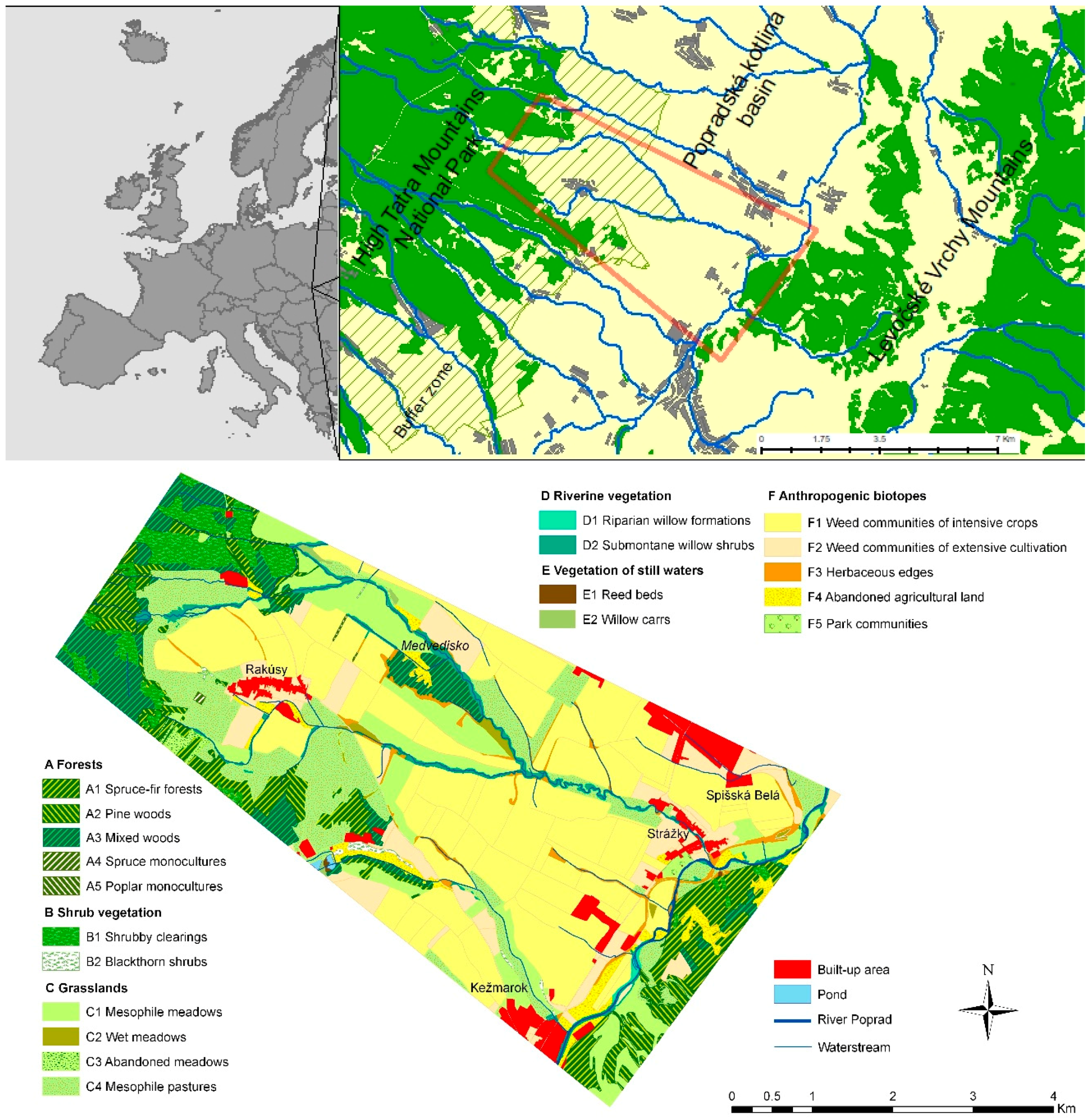
2.1. Study Area

The study area covers 33.9 km2 and is situated in the northern part of Slovakia (Figure 1), in the Popradská kotlina basin located between the High Tatra Mountains and Levočské vrchy Mountains. The study area was chosen because of its ecological perspective as potential functional biocorridor connecting two different mountain ranges. The rural landscape is composed of patches of different vegetation types. The altitude ranges from 600 m to 750 m asl. The area is characterized by a moderately cool climate region, built by flysh layers covered by Quartenary sediments mainly glacio-fluvial and fluvial sediments. The potential natural vegetation of the study region belongs to the Western-Carpathian flora (Carpaticum occidentale) represented by fir and firspruce forests (alliance Abietion Březina et Hadač ex Hadač 1965, Piceion excelsae Pawlowski ex Pawlowski et al. 1928) and submontane alder forests along the watercourses (alliance Alnion glutinosae Malcuit 1929). Vegetation structure is described in detail in Reference [22]. From the socioeconomic perspective, the area covers the edge and hinterland of the city of Kežmarok, which is also the center of the district.
The present vegetation and landscape structure are largely affected by the past political and economic changes and natural disturbances. From the socio-economical perspective, the area historically underwent a large exodus of inhabitants with foreign nationality, massive collectivization of the land through socialism, its restitution and then privatization in post-socialism and the reemergence of subsidies in forestry and agriculture in the EU accession and membership period [23,24]. Each period largely influenced the complexity and amount of land use types related to that area. In addition, a part of the study area was a non-accessible military area until 1999 which still significantly influences its current land use and vegetation structure. The forest patches in the study area were also affected by natural disturbances; specifically a wind calamity that occurred in 2004 and destroyed most of the Prius stands in the High Tatras National Park [25].

2.2. Actual Vegetation

The actual vegetation was mapped according to CORINE Biotopes methodology [26]. A field research campaign on vegetation was realized in 2009 and focused on detailed large-scale mapping of plant communities, their boundaries, and preliminary classification according to the nomenclature of biotopes [26]. While species composition of plant communities was characterized in detail in Reference [22], below we described only the main components of the vegetation structure. The actual vegetation along the river Poprad consists of riparian willow formations (Salix triandra, Salix fragilis, Salix caprea) (Figure 1). The riverine vegetation along smaller watercourses has a character of submontane willow shrubs (Salix purpurea, Salix fragilis, Alnus incana). The forests of nearest mountains represent interactive and buffer zones of protected areas of High Tatra Mts. National Park and Levočské vrchy Mts. protected by the Natura 2000 network. Forests consist of a mosaic of spruce-pine forests (Picea abies, Pinus sylvestris), pine woods (Pinus sylvestris), and mixed pioneer woods (Betula pendula, Sorbus aucuparia, Populus termula, Pinus sylvestris, Alnus glutinosa). Forests of High Tatra Mountains contain a high number of shrubby clearings (Rubus idaeus, Rubus caesius, Sambucus racemosa, Sambucus nigra), which cover the vast areas of the wind calamity of 2004. Grasslands in the chosen area consist of mesophile meadows, wet meadows, and mesophile pastures. More than a third of the study area consists of arable lands with weed communities of crops and to a lesser extent, extensive cultivation. Some agricultural parcels, especially close to the forest, were abandoned and cover 2.59% of all study area.

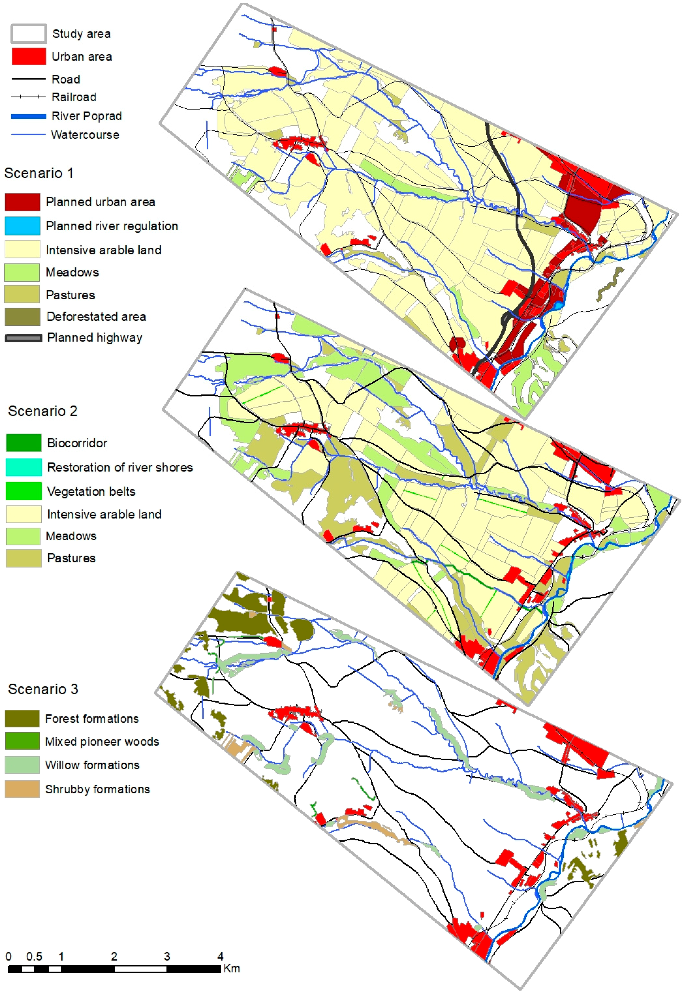
2.3. Land Use Scenarios

To assess the impact of future developments, we constructed three different scenarios of states of biotopes. The scenarios represent the variation of the landscape structure covering a plausible range of pathways of landscape development and comprise the storylines of (1) Maximum territorial development, (2) Restoration, and (3) Land abandonment (Figure 2 and Table 1).

2.3.1. Maximum Territorial Development

In this scenario, we assumed a large increase in development in agriculture, forestry, and built-up area. In the agricultural area, we expected an increase in the amount of arable land. In forestry, we assumed a trend of afforestation in Levočské vrchy Mts. based on findings in Reference [27]. The built-up area in the scenario included all changes proposed in existing spatial plans, as, e.g., increase of built-up and factory areas of nearby towns, new road construction and removal of trees in zones of river regulation.

2.3.2. Restoration

In this scenario, we assumed agricultural optimization by dividing large arable fields into smaller parcels by following the rules for the protection of soil against to erosion [28] and the re-use of abandoned meadows and pastures. A few elements of nature conservation were also considered here: renaturalization of river banks and localization of a new regional biocorridor between the High Tatra Mts. and Levočské vrchy Mts. We used the Least Cost-Path Analysis in ArcGIS10.3 to identify the shortest path between those two core areas. The goal of this scenario was to reach a balance between agricultural use and nature conservation.

2.3.3. Land Abandonment

In this scenario, we assumed land abandonment followed by natural succession. The main elements were: conversion of abandoned agricultural fields into shrubs and conversion of abandoned pastures covered mostly by pioneer shrubs into the class of mixed pioneer woods. We also assumed a fast-spreading plant species as Salix caprea, S. fragilis, S. cinerea (riparian willow and submontane formations), Betula pendula (mixed pioneer woods), and Rubus idaeus (shrubby clearings) into neighboring pastures. For this purpose, we buffered the potential succession spread by medium distance dispersal of tree diaspores [29]. In this scenario, we also assumed decreasing agricultural intensity and no growth of urban areas.

2.4. Modeling

2.4.1. Selection of Representative Species

To assess the changes in the configuration of the different ecosystems in the area, six species with different habitat requirements and dispersal distances were selected (Table 2). The selection was discussed with zoologists to find representative species of main habitats in the study area: riparian forests (Common frog and Water shrew), grasslands (Sand lizard and European ground squirrel), and forests (Hazel dormouse and Red squirrel). For all six species, the size of the study area corresponds with the size of a metapopulation. Therefore, species like Lynx are not chosen as this species’ home range exceeded the size of the study area. Water shrew were chosen as they might be the characteristic species for the submontane willow shrubs habitat. European ground squirrel were chosen according to the historical appearance on foothills of High Tatra Mts. [30]. The habitat requirements of species required for the model, such as parameters of dispersal, home range distances, and carrying capacities, were calibrated based on the literature and expert knowledge (Table 2).

2.4.2. The Model LARCH

For the assessment of the population viability of the selected species, LARCH (Landscape ecological Analysis and Rules for the Configuration of Habitat) was used. LARCH has been developed to assess the potential biodiversity in the landscape [21,31] and has been used for impact assessments of land changes [32,33,34], planning of ecological networks and corridors [18,31], and in studies assessing potential impacts of climate change to species viability [35,36].
As input, LARCH requires species-specific habitat data (a vegetation or land use map) and ecological parameters (home range, dispersal distance, and carrying capacity for all habitat types). These parameters were defined according to multiple literature resources and empirical studies. The model itself also contains parameters and standards for area requirements for viable (meta)populations based on simulations carried out with the dynamic population model [37,38]. Actual species distribution or abundance data are not required for LARCH since the assessment is based on the potential for an ecological network of a species. According to the habitat distribution and estimated carrying capacities, the model evaluates the size and viability of local populations. The habitat patches within the home range of a species are considered as part of one local population. Local populations can be classified as small populations, key populations, and minimum viable populations (MVP) based on the quality and size of the patches [21,37]. Local populations within dispersal distance of a species belong to one network. The size of the network is assessed by LARCH and considered viable when (1) at least one patch in the network exceeds MVP size, (2) there is at least one key population that is supported by several other small populations to guarantee one immigrant per generation, or (3) the network consists only of small patches but the total network size is large [37]. The carrying capacity of the different types of networks is compared with predefined standards ensuring an extinction risk of less than 5% in 100 years [37]. LARCH estimates the viability of each selected species.

3. Results

3.1. Current State

The model outputs show that at present most of the species analyzed form relatively large local populations that are well connected in ecological networks. Regarding the potential population size, Sand lizard, Common frog, and Hazel dormouse are the most numerous (Table 3). Riparian forest species like Water shrew forms a smaller ecological network due to their specific habitat of watercourse shores. Lack of suitable habitat in the study area is found for European ground squirrel, which may form only small populations here.

3.2. Scenarios

3.2.1. Maximum Territorial Development

The increase of utilized arable land as proposed in scenario 1 is expected to result in an overall reduction of 72% of grasslands, which will lead to a decrease in population size of grassland species, most markedly in the case of the European ground squirrel. LARCH predicts the decrease of grassland size will have an impact on the viability of the assessed species. The networks will decrease from sustainable to nearly sustainable.
Removal of trees on river regulation zones will result in a reduction of 5% of riparian forests and willow scrubs, mostly the middle stretch of the River Poprad and Čierna voda watercourse (Figure 2). LARCH predicts a decrease of Water shrew and Common frog population size due to the destruction of their optimal habitats. The networks of these species will also decrease from sustainable to nearly sustainable.

3.2.2. Restoration

The realization of a biocorridor in this scenario assumes an increase of broad-leaved forest. The appearance of new forested patches would likely lead to an increase in population size of Dormouse and Red squirrel. The biocorridor connects isolated forest patches on edges of the study area resulting in one large sustainable network for Hazel dormouse.
The spatial configuration of arable land and grasslands in this scenario leads to a potential increase of 9.4% of the European ground squirrel population, resulting in a highly sustainable ecological network for this species. This result was partially a consequence of changed configuration of habitat patches on basis of dispersal distance, which seems practical knowledge for the improvement of the viability of endangered species.

3.2.3. Land Abandonment

Afforestation of abandoned grasslands and natural willow forest succession foreseen in this scenario will result in an increase of 4% of continuous forests dominated by broad-leaved species. A proportional increase of willow shrubs might lead to a higher spatial cohesion of habitats for Common frog and Water shrew.
A possible increase of mixed pioneer woods and shrubs from low-productive grasslands in this scenario caused a decrease of −17% of pastures and meadows. As pastures and meadows are optimal habitats for the European ground squirrel and Sand lizard, such change would lead to a higher degree of fragmentation of their remaining habitats. In the case of the Sand lizard, the fragmentation leads to an increase of local populations of almost three times in comparison to the present situation. The model predicts a decrease of the total population size to one quarter compared to the current population size (Table 3).

4. Discussion

By using the scenario assessment in combination with population modeling, our study provides important support for landscape planning process in Slovakia. Using the LARCH model, we found that the present configuration of the landscape provides suitable conditions for most chosen species. The analysis of different management scenarios in the study area, however, indicates that populations of the Water shrew and the Common frog will most likely be negatively affected by the growth of new settlements, construction of roads, and reduction of riparian forests and willow scrubs (most prevailing in “Maximum territorial development” scenario). The increase of built-up areas in the surroundings of towns (also assumed in the spatial plans), would lead to a coherent strip of built-up area along the river Poprad (0.25–1 km wide). Since dense urbanized areas and highways act as main barriers and unsuitable habitats to common frog distribution [46], the new constructions would probably result in significant barriers for movement of animals in relation to river sites leading to fragmentation and isolation of their local populations. Riparian species are generally also sensitive to water quality, which may be harmed by intensifying of agricultural production, i.e., in case of Water shrew, there were no signs of habitat avoidance in response to human disturbance, but the species was absent from the river catchment with lowest water quality [47]. Besides other effects, the intensification of agriculture might increase the nitrate concentrations of surface waters which is the common trend recorded since the Second World War. The elevated levels of ammonium nitrate can be detrimental to amphibian development, especially for the Common frog, and cause declining populations [48].
Another expected factor negatively impacting the viability of many species is the abandonment of agricultural land followed by spontaneous reforestation. For the Sand lizard, the decrease of suitable habitat resulted in population fragmentation. This will likely affect all other small grassland species as well. In the case of the European ground squirrel, the impact of abandonment might be even worse, due to the specific habitat of managed meadows and pastures this species need. In the past, these areas have been extensively used for grazing, which is currently true for only limited areas as a large decline of production in recent decades has been recorded in this region [49]. Abandonment results in succession processes, worsening the habitat qualities and likely leads to local extinction of the related species [50].
The purpose of the designed restoration scenario was to maintain existing and restore abandonment agricultural fields. We found that the proposed restoration improves habitat configuration and connectivity between local populations especially of specialist species (those using one habitat type, in our study: the European ground squirrel and Hazel dormouse). For both species the proposed scenario positively impacted the species population by the amount and change in the configuration of habitats. Such findings are important for planning due to decreasing numbers of the European ground squirrel in their traditional habitats in Slovakia in recent years as consequence of higher chemigation in agriculture, ending traditional pasture farming, and abandonment of meadows and pastures [30]. Restoration of grazing in combination with the reintroduction of species into their traditional habitats is a good strategy of protecting the European ground squirrel populations in the region [49]. In case of the reintroduction of the European ground squirrel, it is important to consider the hinterland of the landscape, as it is important that newly formed European ground squirrel colonies are in mutual contact with other existing colonies [50].
One of the measures in the “Restoration” scenario was proposing a biocorridor at a regional level. The biocorridor would connect the Biosphere reserve Tatras and regional biocentre Zlatý vrch (Levočské vrchy Mts. by a continuous strip of forest and ecotone formations. According to our results, the Hazel dormouse benefitted the most from such changes as the biocorridor connects two isolated local populations into one network population that is more stable. This confirms the knowledge that habitat specialist species will benefit most from habitat corridors [51], because habitats of specialist species usually contrast strongly with surrounding land use types in fragmented landscapes and corridors are needed to cross unsuitable areas. Considering the current land cover configuration in Slovakia (e.g., CORINE land cover dataset) many potential areas that can act as biocorridors are currently discontinued [52]. Our results suggest that the reinstatement of biocorridor management, especially the filling of nonforested gaps, may increase rates of successful dispersal of the Hazel dormouse as was stated in Reference [51]. Constructing a continuous corridor and arranging all necessary fauna passages is important to consider avoiding the negative effects of traffic to animal species due to the construction of new roads. The scenario assessment we presented is a powerful tool for evaluation of the effects of land cover changes in the human-dominated landscape.
The current situation in our study area provides suitable conditions for most generalist species, but not for specialist species, what confirms the results of a similar study [32]. Further spread of settlement and high intensity of agricultural use would negatively impact all investigated species. Further abandonment followed by spontaneous reforestation would have a positive impact for forest and ecotone species, but not for grassland species. We demonstrated that by implementing the “Restoration” scenario, a combined conservation of generalist and specialist species can be realized. This result emphasizes the possibility for the successful combination of nature conservation and agricultural use while keeping a conservative variant of infrastructure and development planning.
The scenarios analyzed in our study were developed on the main land change trajectories in the region [24]. As the most probable land change trajectory is scenario 1, we modeled urbanization, which is characterized as the increase of built-up and industrial areas and construction of new roads [2]. As the aim of nearby towns representatives is to increase the job opportunities, they largely subsidize the establishment of new industrial sites, which may improve the rates of unemployment and attractiveness of the region. Our results show that the urban sprawl in the study area will detrimentally impact most of the evaluated species. Thus, a sensitive approach to infrastructure and construction planning with environmental impact assessment is necessary. Less likely to occur in the future is the spread of agricultural areas into the surrounding landscape, which was assumed within the scenarios. It confirms continuous abandonment, which may trigger the increase of land use intensity on surrounding agricultural plots (polarization of agricultural production).
Agricultural land abandonment and afforestation is nowadays a widespread trend in Europe [2] and especially in post-socialist countries [53]. Therefore, we can expect an ongoing process of natural succession and afforestation in remote areas under extensive land use with difficult access [54].
Presented results show the capability of the LARCH model in assessing functional ecological networks, concerning the survival or even extinction of existing species. Such an approach puts the “species perspective” insights into various aspects of development, e.g., water management of different areas [18]. However, such assessments have limitations and include a high level of uncertainty. While setting up the model we found, similar to different studies [55,56], a large sensitivity of modeling outcomes based on input parameters. Even small alterations in the parameter values (e.g., parameters used for translating habitat type and area into carrying capacity) may lead to significant differences in the modeling output. Setting up the parameters is, therefore, crucial but also a time-consuming task. The merits of the approach are, that one can calculate these statistics not only for existing landscapes but for future projections defined for other purposes [21]. Furthermore, it is emphasized by authors [21] that, the assessment method was intended for the comparison scenarios and focuses on the main differences between the results for the various scenarios and species not on the absolute values of the results.

5. Conclusions

The scenarios analyzed in our study were developed on the basis of main expected land use transitions in central European countries, namely an increase of settlement and infrastructure and land abandonment and spontaneous reforestation on agricultural fields. Our results showed that the present conditions in the study area still offer suitable conditions for most of the investigated species. However, we also found possible land use transformations that modify landscape elements composition mostly in agricultural landscape and improvement of habitat conditions for selected forest, grassland, and riparian species. Recovery of riparian forest, extensive management of grasslands, and realization of a biocorridor are concrete actions necessary to accomplish these goals. We conclude that the recovery of key habitats is critical for preventing further loss of biodiversity, especially in human-dominated landscapes. We consider the procedure used for the evaluation of possible future scenarios useful in landscape planning processes, due to highlighting potential impacts, before real changes to habitats occur. To come to balanced development in spatial planning processes, which take into account both environmental and societal needs, is important [18]. We suggest that scenario modeling should be widely used in the process of decision making for spatial development, in particular in Slovakia where the landscape exhibits turbulent changes.

Author Contributions

Z.P. conceptualized and designed the study; Z.P. and R.P. (Robert Pazúr) performed the fieldwork and data collection, Z.P. and R.P. (Rogier Pouwels) performed the data analysis and interpretation; R.P. (Rogier Pouwels), J.R., J.B., J.K., J.O., R.P. (Robert Pazúr) assisted in the interpretation; reviewing and improving of the early versions of the manuscript.

Funding

This article has been written under the Project No. 1/0052/17 “Suburban landscape: analysis of land cover changes and organization of socio-economic functions under the effect of urbanization and suburbanization processes” and Grant for young scientists GaPU 39/2017 funded by the University of Prešov, Slovakia.

Acknowledgments

We thank Peter Miklós, Peter Mikulíček, and Dávid Janzdík for their help in choosing representative animal species in the selected study area and setting parameters about home range and dispersal distance. The LARCH model was kindly provided by Alterra, the Netherlands.

Conflicts of Interest

The authors declare no conflict of interest.

References

  1. Fuchs, R.; Herold, M.; Verburg, P.H.; Clevers, J.G.P.W.; Eberle, J. Gross changes in reconstructions of historic land cover/use for Europe between 1900 and 2010. Glob. Chang. Biol. 2015, 21, 299–313. [Google Scholar] [CrossRef] [PubMed]
  2. Feranec, J.; Jaffrain, G.; Soukup, T.; Hazeu, G. Determining changes and flows in European landscapes 1990–2000 using CORINE land cover data. Appl. Geogr. 2010, 30, 19–35. [Google Scholar] [CrossRef]
  3. Vitousek, P.M.; Mooney, H.A.; Lubchenco, J.; Melillo, J.M. Human domination of earth’s ecosystems. Science 1997, 277, 494–499. [Google Scholar] [CrossRef]
  4. Alberti, M.; Correa, C.; Marzluff, J.M.; Hendry, A.P.; Palkovacs, E.P.; Gotanda, K.M.; Hunt, V.M.; Apgar, T.M.; Zhou, Y. Global urban signatures of phenotypic change in animal and plant populations. Proc. Natl. Acad. Sci. USA 2017, 114, 8951–8956. [Google Scholar] [CrossRef] [PubMed] [Green Version]
  5. Guettè, A.; Godet, L.; Juigner, M.; Robin, M. Worldwide increase in Artificial Light at Night around protected areas and within biodiversity hotspots. Biol. Conserv. 2018, 223, 97–103. [Google Scholar] [CrossRef]
  6. Tapia-Armijos, M.F.; Homeier, J.; Draper Munt, D. Spatio-temporal analysis of the human footprint in South Ecuador: Influence of human pressure on ecosystems and effectiveness of protected areas. Appl. Geogr. 2017, 78, 22–32. [Google Scholar] [CrossRef]
  7. Wilson, T.S.; Sleeter, B.M.; Sleeter, R.R.; Soulard, C.E. Land-use threats and protected areas: A scenario-based, landscape level approach. Land 2014, 3, 362–389. [Google Scholar] [CrossRef]
  8. van der Ree, R.; Jaeger, J.A.G.; van der Grift, E.A.; Clevenger, A.P. Effects of roads and traffic on wildlife populations and landscape function: Road ecology is moving towards larger scales. Ecol. Soc. 2011, 16, 48. [Google Scholar] [CrossRef]
  9. Shepard, D.B.; Kuhns, A.R.; Dreslik, M.J.; Philips, C.A. Roads as barriers to animal movement in fragmented landscapes. Anim. Conserv. 2008, 11, 288–296. [Google Scholar] [CrossRef] [Green Version]
  10. Young, J.; Richards, C.; Fischer, A.; Halada, L.; Kull, T.; Kuzniar, A.; Tartes, U.; Uzunov, Y.; Watt, A. Conflicts between biodiversity conservation and human activities in the Central and Eastern European Countries. Ambio 2007, 36, 545–550. [Google Scholar] [CrossRef]
  11. Navarro, L.M.; Pereira, H.M. Rewilding abandoned landscapes in Europe. Ecosystems 2012, 15, 900–912. [Google Scholar] [CrossRef]
  12. Halada, Ľ.; Ružičková, H.; David, S.; Halabuk, A. Semi-natural grasslands under impact of changing land use during last 30 years: Trollio-Cirsietum community in the Liptov region (N Slovakia). Community Ecol. 2008, 9, 115–123. [Google Scholar] [CrossRef]
  13. Gustavsson, E.; Lennartson, T.; Emanuelsson, M. Land use more than 200 years ago explains current grassland plant diversity in a Swedish agricultural landscape. Biol. Conserv. 2007, 138, 45–59. [Google Scholar] [CrossRef]
  14. Hunziker, M.; Kienast, F. Potential impacts of changing agricultural activities on scenic beauty—A prototypical technique for automated rapid assessment. Landsc. Ecol. 1999, 14, 161–176. [Google Scholar] [CrossRef]
  15. Jongman, R.H.G. Homogenisation and fragmentation of the European landscape: Ecological consequences and solutions. Landsc. Urban Plan. 2002, 58, 211–221. [Google Scholar] [CrossRef]
  16. Koreň, M.; Šteffek, J.; Kramárik, J.; Maglocký, Š.; Straka, P.; Ružičková, J.; Sabo, P. Národná ekologická sieť—NECONET 1:1000000. In Atlas Krajiny Slovenskej Republiky; Min. Život. Prostr. SR: Bratislava, Slovakia, 2002; p. 256. [Google Scholar]
  17. Hanušin, J.; Beták, J.; Cebecauerová, M.; Grešková, A.; Huba, M.; Ira, V.; Lacika, J.; Lehotský, M.; Podolák, P. Zlepšenie Siete Chránených Území v Oblasti Tatier; Geografický Ústav SAV: Bratislava, Slovakia, 2007; p. 68. [Google Scholar]
  18. Van der Sluis, T.; Romanowski, J.; Matuszkiewicz, J.; Bouwma, I. Comparison of Scenarios for The Vistula River, Poland. In Landscape Ecological Applications in Man-Influenced Areas: Linking Man and Nature Systems; Hong, S.K., Nakagoshi, N., Fu, B., Morimoto, F., Eds.; Springer: Dordrecht, The Netherlands, 2007; pp. 417–433. ISBN 978-1-4020-5488-4. [Google Scholar]
  19. Peterson, G.D.; Cumming, G.S.; Carpenter, S.R. Scenario planning: A tool for conservation in an uncertain world. Conserv. Biol. 2003, 17, 358–366. [Google Scholar] [CrossRef]
  20. Akçakaya, H.; Sjögren-Gulve, P. Population viability analysis in conservation planning: An overview. Ecol. Bull. 2000, 48, 9–21. [Google Scholar]
  21. Verboom, J.; Pouwels, R. Ecological functioning of ecological networks: A species perspective. In Ecological Networks and Greenways: Concept, Design, Implementation; Jongman, R.H.G., Pungetti, G., Eds.; Cambridge University Press: Cambridge, UK, 2004; pp. 56–72. ISBN 0 521 82776 0. [Google Scholar]
  22. Pazúrová, Z.; Falťan, V.; Pazúr, R. Actual vegetation of cultural landscape in northern Slovakia (study area in the Poprad basin). Rev. Biol. Cienc. Terra 2010, 10, 138–147. [Google Scholar]
  23. Pazúr, R.; Lieskovský, J.; Feranec, J.; Oťaheľ, J. Spatial determinants of abandonment of large-scale arable lands and managed grasslands in Slovakia during the periods of post-socialist transition and European Union accession. Appl. Geogr. 2014, 54, 118–128. [Google Scholar] [CrossRef]
  24. Pazúr, R.; Bolliger, J. Land changes in Slovakia: Past processes and future directions. Appl. Geogr. 2017, 85, 163–175. [Google Scholar] [CrossRef]
  25. Falťan, V.; Pazúrová, Z. Hodnotenie poškodenia vegetácie veternou kalamitou na rôznych typoch geotopov v okolí Danielovho domu (Vysoké Tatry). Geogr. Čas. 2010, 62, 75–88. [Google Scholar]
  26. Ružičková, H.; Halada, Ľ.; Jedlička, L.; Kalivodová, E. Biotopy Slovenska; Ústav Krajin. Ekol. SAV: Bratislava, Slovakia, 1996; p. 1992. [Google Scholar]
  27. Kopecká, M.; Nováček, J. Hodnotenie fragmentácie krajinnej pokrývky na báze dátových vrstiev CORINE Land Cover. Geogr. Čas. 2008, 60, 31–44. [Google Scholar]
  28. STN 75 4501. 2000: Hydromeliorácie: Protierózna Ochrana Poľnohospodárskej Pôdy; UNMS SR: Bratislava, Slovakia, 2000. [Google Scholar]
  29. Daniš, D. Prognózy Dynamiky Sukcesných Procesov a Ich Vplyv na Krajinu PIENAP-u; Technická Univerzita: Zvolen, Slovakia, 2008; p. 133. ISBN 978-80-89183-47-0. [Google Scholar]
  30. Ambros, M. Stav poznania rozšírenia sysľa pasienkového (Spermophilus citellus) na Slovensku v rokoch 1996 až 2008. Lynx 2008, 39, 219–233. [Google Scholar]
  31. Opdam, P.; Verboom, J.; Pouwels, R. Landscape cohesion: An index for the conservation potential of landscapes for biodiversity. Landsc. Ecol. 2003, 18, 113–126. [Google Scholar] [CrossRef]
  32. Franz, K.W.; Romanowski, J.; Saavedra, D. Landscape and Urban Planning Effects of prospective landscape changes on species viability in Segre River valley, NE Spain. Landsc. Urban Plan. 2011, 100, 242–250. [Google Scholar] [CrossRef]
  33. Cormont, A.; Vos, C.C.; Verboom, J.; van Turnhout, C.A.M.; Foppen, R.P.B.; Goedhart, P.W. Population dynamics of Great Bittern (Botaurus stellaris) in the Netherlands: Interaction effects of winter weather and habitat fragmentation. Reg. Environ. Chang. 2013, 14, 943–952. [Google Scholar] [CrossRef]
  34. Snep, R.P.H.; Ottburg, F.G.W.A. The ‘habitat backbone’as strategy to conserve pioneer species in dynamic port habitats: Lessons from the natterjack toad (Bufo calamita) in the Port of Antwerp (Belgium). Landsc. Ecol. 2008, 23, 1277. [Google Scholar] [CrossRef]
  35. Rüter, S.; Vos, C.C.; van Eupen, M.; Rühmkorf, H. Transboundary ecological networks as an adaptation strategy to climate change: The example of the Dutch—German border. Basic Appl. Ecol. 2014, 15, 639–650. [Google Scholar] [CrossRef]
  36. Malinowska, A.H.; van Strien, A.J.; Verboom, J.; Wallis deVries, M.F.; Opdam, P. No Evidence of the Effect of Extreme Weather Events on Annual Occurrence of Four Groups of Ectothermic Species. PLoS ONE 2014, 9, e110219. [Google Scholar] [CrossRef] [PubMed]
  37. Verboom, J.; Foppen, R.; Chardon, P.; Opdam, P.; Luttikhuizen, P. Introducing the key-patch approach for habitat networks with persistant populations: An example for marshland birds. Biol. Conserv. 2001, 100, 89–101. [Google Scholar] [CrossRef]
  38. Vos, C.C.; Verboom, J.; Opdam, P.F.M.; Ter Braak, C.J.F. Toward Ecologically Scaled Landscape Indices. Am. Nat. 2001, 157, 24–41. [Google Scholar] [CrossRef] [PubMed]
  39. Beschkov, V.; Delcheva, M.; Dobrev, D. Breeding Movements and Strict Fidelity to the Place of Egg-Laying of the Common Toads Bufo Bufo Bufo (L.) in Stream Water Reservoir. Ekologija 1986, 19, 62–70. [Google Scholar]
  40. Baker, J.M.; Halliday, T.R. Amphibian colonization of new ponds in an agricultural landscape. Herpetol. J. 1999, 9, 55–63. [Google Scholar]
  41. Sound, P.; Veith, M. Radiotelemetrische untersuchungen zu raumbedarf, habitatwahl und innerhabitatbewegungen der westlichen smaragdeidechse (Lacerta bilineata Daudin 1802) im mittelrheintal, mit vergleichen zwischen männchen und weibchen. In Beiträge zur Naturgeschichte und Zum Schutz der Smaragdeidechsen (Lacerta s.); Elbing, K., Nettmann, H.K., Eds.; Mertensiella, Chimaira: Frankfurt am Main, Germany, 2001; Volume 13, pp. 195–203. [Google Scholar]
  42. Van der Grift, E.A.; van der Sluis, T. Design of an Ecological Network for Piano di Navelli (Abruzzo); Alterra: Wageningen, The Netherlands, 2003; p. 44. [Google Scholar]
  43. Lange, R.; Twisk, P.; van Winden, A.; van Diepenbeek, A. Zoogdieren van West-Europa; Stichting Uitgeverij Koninklijke Nederlanse Natuurhistorische Vereniging: Utrecht, The Netherlands, 1994; 400p. [Google Scholar]
  44. Stefanov, V.; Biserkov, V. Ecoprofile of European Ground Squirrel (Spermophilus citellus); Alterra: Wageningen, The Netherlands, 2007; p. 15. [Google Scholar]
  45. Van Rooij, S.A.M.; van der Sluis, T.; Steingröver, E.G. Development of an Ecological Network for Persiceto (Emilia-Romagna, Italy); Alterra: Wageningen, The Netherlands, 2003; p. 65. [Google Scholar]
  46. Decaut, S.; Manel, S.; Miaud, C.; Luque, S. Integrative approach for landscape-based graph connectivity analysis: A case study with the common frog Rana temporaria in human-dominated landscapes. Landsc. Ecol. 2012, 27, 267–279. [Google Scholar] [CrossRef]
  47. Greenwood, A.; Churchfield, S.; Hickey, C. Geographical distribution and habitat occurrence of the Water Shrew (Neomys fodiens) in the Weald of South-East England. Mammal Rev. 2002, 32, 40–50. [Google Scholar] [CrossRef]
  48. De Wijer, P.; Watt, P.J.; Oldham, R.S. Amphibian decline and aquatic pollution: Effects of nitrogenous fertiliser on survival and development of larvae of the frog Rana temporaria. Appl. Herpetol. 2003, 1, 3–12. [Google Scholar] [CrossRef]
  49. Stefanov, V.; Markova, E. Distribution and Current status of the European Souslik (Spermophillus citellus L.) in Sofia Valley and the Adjacent Areas. Biotechnol. Biotechnol. Equip. 2009, 23, 381–384. [Google Scholar] [CrossRef]
  50. Matějů, J.; Říčanová, Š.; Ambros, M.; Kala, B.; Hapl, E.; Matějú, K. Reintroductions of the European Ground Squirrel (Spermophilus citellus) in Central Europe (Rodentia: Sciuridae). Lynx 2010, 41, 175–191. [Google Scholar]
  51. Bright, P.W. Behaviour of specialist species in habitat corridors: Arboreal dormice avoid corridor gaps. Anim. Behav. 1998, 56, 1485–1490. [Google Scholar] [CrossRef] [PubMed]
  52. Slovstat. Data from the Statistical Database of the Slovstat. Available online: http://portal.statistics.sk/ (accessed on 14 November 2015).
  53. Levers, C.; Schneider, M.; Prishchepov, A.V.; Estel, S.; Kuemmerle, T. Spatial variation in determinants of agricultural land abandonment in Europe. Sci. Total Environ. 2018, 644, 95–111. [Google Scholar] [CrossRef] [PubMed]
  54. MacDonald, D.; Crabtree, J.; Wiesinger, G.; Dax, T.; Stamou, N.; Fleury, P.; Lazpita, J.G.; Gibon, A. Agricultural abandonment in mountain areas of Europe: Environmental consequences and policy response. J. Environ. Manag. 2000, 59, 47–69. [Google Scholar] [CrossRef] [Green Version]
  55. Houweling, H.; Jansen, M.J.W.; Kalkhoven, J.T.R.; Pouwels, R. LARCH-Rivier: Gevoeligheidsanalyse op Basis van de Studie DELTA-ECONET; Alterra, RIZA: Wageningen, The Netherlands, 1999. [Google Scholar]
  56. Romanowski, J. Vistula river valley as the ecological corridor for mammals. Pol. J. Ecol. 2007, 55, 805–819. [Google Scholar]
Figure 1. Actual vegetation in the study area.
Sustainability 10 03602 g001
Figure 2. Main changes in land use in three scenarios.
Sustainability 10 03602 g002
Table 1. Habitat type change in scenarios in comparison to present situation.
Habitat TypePresent Situation (ha)Scenario of Land Change (%)
Scenario 1Scenario 2Scenario 3
Spruce monocultures1.28100100100
Poplar monocultures1100100100
Park communities6.54100100100
Pine woods76.64100100100
Spruce-fir forests234.0198100100
Mixed woods212.21100105236
Shrubby clearings148.011001001
Blackthorn shrubs8.28100100257
Abandoned meadows11.0600100
Herbaceous edges24.6598109138
Mesophile meadows324.3732114100
Abandoned agricultural land76.480063
Mesophile pastures433.421810974
Reed beds1.17100100100
Wet meadows15.1492100100
Willow carrs5.02100100169
Reed canary grass formations18.95978791
Riparian willow formations3.56100100151
Submontane willow shrubs79.5396103239
Weed communities of extensive crops257.8181100100
Weed communities of intensive crops1265.09142100100
Urban and industrial areas150.16195100100
Table 2. Habitat requirements and dispersal distances of modeled species.
ClassSpeciesHabitatHome Range (m)Dispersal Distance (m)References
AmphibiansCommon frog (Rana temporaria)Riparian forest150950[39,40]
ReptilesSand lizard (Lacerta agilis)Grassland225750[41,42]
MammalsWater shrew (Neomys fodiens)Riparian forest502000[43,44]
European ground squirrel (Spermophilus citellus)Grassland5002000[45]
Hazel dormouse (Muscardinus avellanarius)Forest1501500[46]
Red squirrel (Scirius vulgaris)Forest1005000[47]
Table 3. Number of viable networks, predicted changes in the total abundance of species analyzed. Values for present situation expressed in reproductive units (RU = Reproductive Unit; breeding pairs or females depending on the breeding system of particular species), values for scenarios expressed as a percentage of the present situation (where present situation = 100%).
SpeciesPresent SituationScenario 1Scenario 2Scenario 3
No.(RU)No.(%)No.(%)No.(%)
Red squirrel1421198.91102.11129.8
Hazel dormouse21034299.41102.12108
European ground squirrel2867-17.71109.4174
Sand lizard12986124.11103.6187.4
Water shrew1171-93.31102.71165.7
Common frog11257-96.11100.51143.5

