Governance Challenges in an Eastern Indonesian Forest Landscape
by
 , , , ,
Rebecca A. Riggs
1,2,* ,
,
James D. Langston
1,2,
Chris Margules
1,2,3,
Agni Klintuni Boedhihartono
1,2,4,
Han She Lim
1,
Dwi Amalia Sari
1,5,
Yazid Sururi
1 and
Jeffrey Sayer
1,2,4 1
Centre for Tropical Environmental and Sustainability Science, College of Science and Engineering, James Cook University, Cairns, QLD 4870, Australia
2
Tanah Air Beta, Batu Karu, Tabanan, Bali 82152, Indonesia
3
Faculty of Mathematics and Natural Sciences, University of Indonesia, Campus UI Depok, Java Barat 16424, Indonesia
4
Faculty of Forestry, Department of Forest & Conservation Sciences, University of British Columbia, 2329 West Mall, Vancouver, BC V6T 1Z4, Canada
5
The Supreme Audit Board of Indonesia, Jln Jend. Gatot Subroto No. 31, Jakarta Pusat 10210, Indonesia
*
Author to whom correspondence should be addressed.
Sustainability 2018, 10(1), 169; https://doi.org/10.3390/su10010169
Submission received: 24 October 2017
/
Revised: 17 December 2017
/
Accepted: 7 January 2018
/
Published: 11 January 2018
(This article belongs to the Special Issue Sustainable Landscape Management)
Abstract
:Integrated approaches to natural resource management are often undermined by fundamental governance weaknesses. We studied governance of a forest landscape in East Lombok, Indonesia. Forest Management Units (Kesatuan Pengelolaan Hutan or KPH) are an institutional mechanism used in Indonesia for coordinating the management of competing sectors in forest landscapes, balancing the interests of government, business, and civil society. Previous reviews of KPHs indicate they are not delivering their potential benefits due to an uncertain legal mandate and inadequate resources. We utilized participatory methods with a broad range of stakeholders in East Lombok to examine how KPHs might improve institutional arrangements to better meet forest landscape goals. We find that KPHs are primarily limited by insufficient integration with other actors in the landscape. Thus, strengthened engagement with other institutions, as well as civil society, is required. Although new governance arrangements that allow for institutional collaboration and community engagement are needed in the long term, there are steps that the East Lombok KPH can take now. Coordinating institutional commitments and engaging civil society to reconcile power asymmetries and build consensus can help promote sustainable outcomes. Our study concludes that improved multi-level, polycentric governance arrangements between government, NGOs, the private sector, and civil society are required to achieve sustainable landscapes in Lombok. The lessons from Lombok can inform forest landscape governance improvements throughout Indonesia and the tropics.
1. Introduction
Natural resource governance in Indonesia is complex and operates at multiple scales. Power over land is distributed between State, local governments and civil society in diverse ways. Recent years have seen turbulence in Indonesia’s decentralization, recentralization, and bureaucratic processes [1]. Decentralization transferred power down the hierarchy, strengthening local claims over forest resources and giving rise to tenure conflict [2]. Discrepancies between de facto and de jure rights have proliferated in recent years as unclear institutional arrangements led to competition between overlapping claims on forest lands [3]. As a response to these competing and overlapping claims on forest lands, the Indonesian Government established Forestry Management Units (KPH, Kesatuan Pengelolaan Hutan) to integrate natural resource management in forest landscapes [4,5].
Initially introduced in the 1999 Forestry Law, KPHs are mandated to implement sustainable forest management at watershed scale and to be responsive to local economic, social, and conservation goals [4]. They are expected to develop relationships with organizations, government institutions and forest license holders based on coordination, integration, and synchronization. As such, KPHs are mandated to deliver good forest governance, balancing “roles and responsibilities of the government, business community, and civil society, supported by accountable policies and trustworthy law enforcement institutions” [4].
Eight years after their establishment, Forest Management Units have not yet achieved their desired influence over forest management in Indonesia. While still in their development stage, KPHs are struggling with a “complex and rapidly evolving policy and institutional framework”, creating uncertainty in their role in forest landscapes [6]. Studies examining the effectiveness of KPHs find there is a lack of awareness and participation among stakeholders, which inhibits the implementation of KPH activities [7,8]. Inadequate implementation, in turn, negatively influences KPH legitimacy as an authority and discourages the adoption of KPH policies by other actors in the landscape [7,9]. Sahide et al. [1] find that in some cases, the introduction of KPHs has exacerbated existing power struggles between provincial and district governments over forest jurisdiction and budgets. Analyzing the policy implementation of KPH development in Riau Province, Suwarno et al. [10] argues that the effective implementation of KPHs will require behavioral change in Indonesian forest management culture.
These studies offer important insights for building the institutional infrastructure for KPHs. However, they offer little insight for improving the incentives and institutional relationships for effective implementation of KPH activities. If KPHs are to adequately fulfil their mandate, their priority must be to overcome barriers to their influence over forest landscapes to gain recognition among institutions and civil society as a legitimate steward of forest resources. If effectively implemented, KPHs may not only be proponents of good forest governance, but could also be an instrument for coordinating landscape governance. Two-thirds of Indonesia’s terrestrial landmass is classified as forest estate and it is subject to the second highest deforestation rate globally [11,12]. Most of Indonesia’s landscapes are forest landscapes. Therefore forest institutions have a major role to play in broader landscape governance. As stewards of forest resources, KPHs are intended to manage forests for economic value, harmonize spatial planning arrangements and respond to threats and opportunities affecting forest resources. If they are going to adequately fulfil these roles and responsibilities, KPHs must operate across State forest and other tenure boundaries to effectively diagnose and balance the needs of different actors and networks that shape forest landscapes. As bridging organizations [13,14] they can facilitate better coordination and collaboration between different actors whilst developing a more nuanced understanding of demands on forest resources. Consequently, the KPH may drive progress towards effective governance of forest landscapes in Indonesia, meeting social, economic, and environmental goals of integrated natural resource management.
In this paper, we explore and suggest pathways for the KPH to achieve effective landscape governance to meet its mandate of sustainable forest management and we address challenges for achieving this outcome. Using the case study of East Rinjani KPH on the island of Lombok, Indonesia, we discuss the potential for Indonesian Forest Management Units to coordinate landscape governance. We use the term landscape governance to describe the multi-stakeholder process of negotiation and decision making affecting a landscape, including both government and non-government actors intervening across multiple scales [15]. Using this case study, we aim to demonstrate how strengthening governance is crucial to effectively implementing holistic forest landscape management and how Indonesian KPHs can make progress to address challenges inhibiting their mandate [16]. We unravel the local complexities and provide the depth of understanding of these complexities that is needed to improve local resource management and governance arrangements and capabilities. We demonstrate how KPHs can strengthen their role as bridging organizations in Indonesia to facilitate effective landscape governance and provide incentives to help ensure that civil society and institutions govern resources sustainably and inclusively.
2. Background
2.1. Governance Issues in Indonesia
Forest landscapes in Indonesia are characterized by ambiguity, competition and conflict between de facto and de jure claims on resources. At least nine different ministries and institutions have a role in forest management [17]. Community ownership and diverse tenure arrangements are in the process of being recognized and formalized [18]. Multiple de facto arrangements have always existed in forest areas in Indonesia [19]. Recent legislation committed the Government to allocate over 12.7 million hectares of State forest to communities in coming years [20]. Yet coordinating different visions, missions, and responsibilities in Indonesia is challenging and costly. Conservation NGOs, Indigenous groups, private industries, communities, and government institutions both impact and are influenced by forest management decisions. They also play an important role in forest landscape governance. When incentives for collaboration are absent, each group tends to prioritize its own agenda, framing issues from their own perspective, leading to zero-sum outcomes [1,21]. Opportunities for synergies are replaced by ‘egosektoral’ agendas. For example, restoration of degraded land may often be seen as a technical problem to be solved by a narrow sectoral approach and this may exclude the interests of legitimate stakeholders such as local communities [22]. The result is fragmented governance; institutions working side by side but with minimal cross-scale and cross-sectoral communication [23]. REDD+ (Reduced Emission from Deforestation and Degradation Plus) activities in Indonesia have largely failed because of lack of coordination among sectors and across governance scales [24,25,26].
2.2. Pathways to Strengthening Forest Landscape Governance
The introduction of Forest Management Units in Indonesia provides a conceptual framework for effective governance of forest landscapes. The program gained traction in 2010 with support from the German Development Cooperation (GIZ) and over 400 KPHs were established across Indonesia’s forest estate. KPH can consist of protection units (KPHL), production units (KPHP), or conservation units (KPHK). Among other requirements, KPHs are responsible for facilitating collaboration and synergies between Central, Provincial and Regency/Municipal Governments [27]. Currently KPHs prioritize forest management interventions that include developing inventories and planning for conservation and restoration. They also have the responsibility to manage conflict, socialize national forest policies and promote partnerships between different actors in forest landscapes [6].
KPHs are strategically designed to integrate existing governance frameworks and develop long-term management plans based on local social, cultural, economic, and environmental conditions [4]. They are appropriately positioned to navigate change towards more effective governance. In Indonesia, a shift to effective multi-level or polycentric landscape governance arrangements might help set a course towards sustainable social-ecological systems. Effective multi-level and polycentric governance means matching institutions to social-ecological processes [28]. In a practical sense, it implies collaboration and communication between different institutions at different scales, such that rules and responsibilities concerning resources are appropriately adapted to local conditions [29]. Enhancing governance will require (1) building knowledge of ecosystem dynamics; (2) allowing constant learning to underpin adaptive management; (3) supporting flexible institutions and polycentrism; and (4) developing capacity for dealing with the unpredictable [13]. As a bridging organization, KPHs can support management institutions to work with one another so that they can build consensus on how their landscapes might deliver the optimal range of societal benefits [30]. They can utilize participatory tools such as developing a theory of change to help clarify the way to attain better institutional collaboration [31,32]. A by-product of such arrangements can enable weak organizations to gain capacity through institutional co-dependence and learning.
3. Materials and Methods
3.1. Description of Study Area: Lombok
From ridge to reef, the island of Lombok harbors significant biodiversity, along with some of the poorest human communities in Indonesia. Nusa Tenggara Barat, the province comprising Lombok and Sumbawa, ranks 31 out of the 35 Indonesian provinces in the Human Development Index (HDI) [33]. Since HDI is a measurement of life expectancy, education, and income, a low index indicates that the province is underdeveloped. Low socio-economic status is compounded by the effects of harsh climatic and environmental conditions. The people of Lombok are widely recognized by aid agencies for their vulnerability to droughts, floods, and rising temperatures due to climate change. Water resources are already limited; the current water use index for NTB (the ratio between demand and supply) is considered critically high [34]. As farmers look for alternative water sources, they risk placing unsustainable pressure on Lombok’s spring water and groundwater—the island’s current domestic water supply [35].
Although most of the forest on Lombok remains legally protected, satellite imagery shows deforestation and degradation spreading up Rinjani’s slopes from the more accessible lowlands [36]. Since 1990, 28.6% of Lombok’s forests have been converted to non-forest land uses [36]. Small-scale agricultural expansion is the main driver of forest loss and land-use change [36,37]. Communities on Lombok rely on forests for ecosystem services including water, timber, fuelwood, and non-timber forest products. Ecosystem regulating services include flood protection, erosion control, and pollination of major crops. Communities also assign customary value to the forests for ceremonial purposes and receive income from tourism [38]. State forests occupy 35% of Lombok’s most highly valued and limited resource: land.
3.2. East Lombok
Many of the aforementioned issues are most acute in the regency of East Lombok. High seasonality of rainfall, rising temperatures and water resource scarcity combined with rising population density, lack of economic opportunities and poverty is driving forest conversion and degradation [36,39]. Harsh social and environmental conditions create acute competition for resources and seem irreconcilable with long-term conservation. The system is locked into a feedback loop where poverty and environmental degradation reinforce each other.
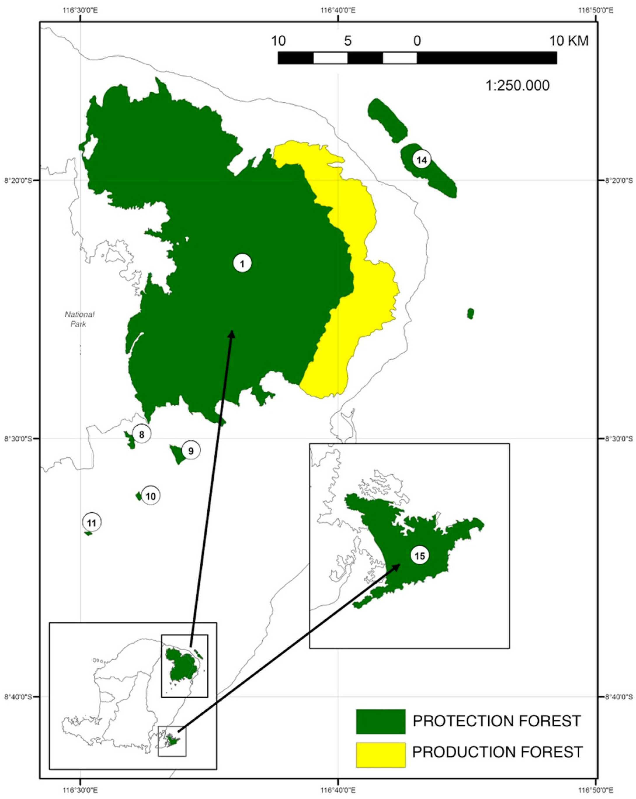
East Lombok regency has a population of 1.2 million and spans 160,600 ha, of which 40% is legally designated as forest [40] (Figure 1). The East Rinjani KPH was established in 2009 under the East Lombok Department of Forestry and Plantations. The forest managed by East Rinjani KPH consists of community forest, one timber concession and Kemitraan areas (Table 1). Kemitraan is the Indonesian term for a ‘partnership’ model—in this case the KPH is working with the local community to plant trees and crops inside the forest boundary for environmental services and to generate local incomes. As the forest in East Lombok ranges from 1600 m to sea level, it encompasses multiple forest types, including moist deciduous, dry deciduous monsoon forest, and mangrove forest. The mangrove forests have largely disappeared from the coast of East Lombok and are now restricted to the small islands of Gili Lawang and Gili Sulat. Land use classification maps [36] show forest conversion to agriculture and shrub land is occurring at the edges of the forest and in populated areas at higher elevations. Shrub land in this case refers to mixed land uses or degraded forest, which are non-forest at present but could return to forest in the future [36]. From our field observations shrub land includes both land degraded by fire and cropland.
The forested slopes of Mt. Rinjani constitute the primary water source for Lombok island [37]. Local communities recognize the relationship between forest cover and water availability; drying springs and unstable river flows are often attributed to deforestation and degradation [42]. Sacred groves exist to protect certain trees for their perceived ability to protect water sources. Sacred groves include exotic species such as mahoni (Sweitenia macrophylla) and indigenous species such as jelateng (Ficus spp.) [43]. Forests and water are linked on many levels including the hydrological continuum and in the socio-cultural beliefs of the community. East Rinjani KPH is only officially responsible for State forest land in East Lombok Regency. However, its potential to facilitate landscape governance means it is also the de facto steward of water resources.
3.3. Methods
The site of East Lombok was selected due to our team’s longstanding engagement in the area and the specific natural resource management challenges of the landscape. Since 2012 we have visited Lombok annually to work with local development partners. Our fieldwork in August 2016 focused on how landscape governance impacts the Forest Management Unit’s integrated natural resource management program. Our approach used interdisciplinary collaborative problem-framing [45] and various visualization and participatory rural appraisal techniques [46] with the aim to co-generate knowledge with local stakeholders for better decision-making [47]. Techniques were selected to help define theory of place and theory of change, addressing the relevant who, what, when, and where questions for landscapes and allowing enquiry into issues that deserves prominence [48]. Relevant and specific methods are described in Table 2.
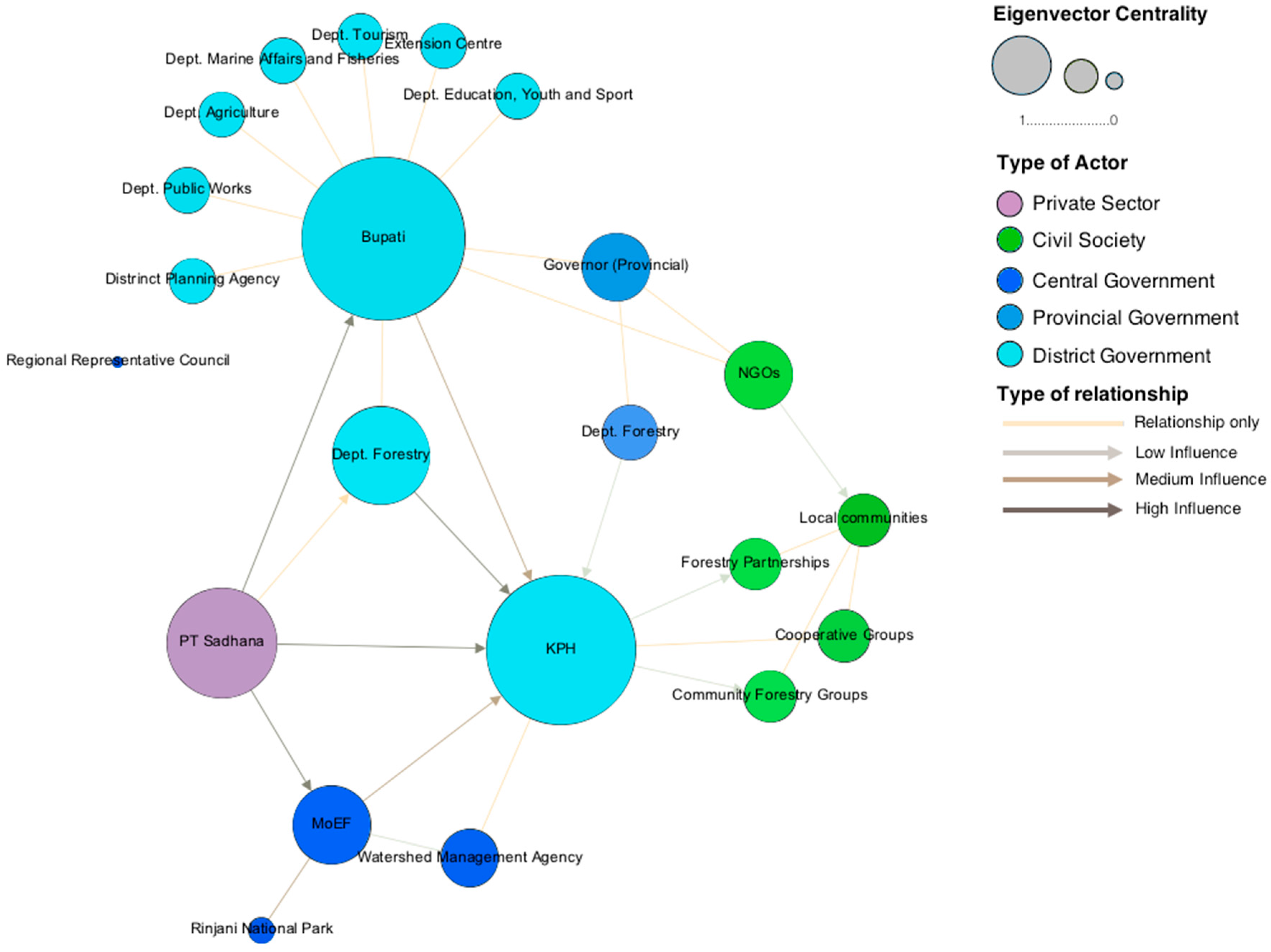
Following preliminary investigations and participatory rural appraisal activities described in Table 2, we facilitated a five-day workshop in East Lombok with members of East Rinjani KPH, University of Mataram forestry students and local NGOs. Invited participants were from Nusa Tenggara and aged between 20 and 35 with varying levels of experience in forest management in Indonesia. Our workshop focused on three landscape issues: reforestation, hydrology, and community needs. We used participatory systems modelling to facilitate broader discussions on the management of social-ecological interactions and revealed the challenges of governance and stakeholder behavior. We then facilitated an actor-network mapping exercise [49] to understand existing governance arrangements. Participants were asked to identify actors in the landscape that either affect or are affected by forest management decisions and to assess power and influence between relationships. We used social network analysis (SNA) software (Gephi 0.9.1) to explore the network. SNA software provided us with an explicit understanding of actor centrality, direction of influence, and types of actors involved. Centrality, calculated through an eigenvector value, symbolizes the importance of an actor, measuring its contribution to the network. Actors or ‘nodes’ with connections to more influential actors are considered to be more influential than those connected with less influential actors [50]. Our actor-network exercise enabled the group to develop a theory of change for the landscape. We identified process and data needs in building this theory of change [51,52]. The theory of change prompted discussion on how to support the staff of East Rinjani KPH to better understand its potential contribution to conservation and development.
4. Results
4.1. Diagnosing Landscape Governance in East Lombok
Lombok’s natural resources are governed by both traditional and non-traditional decision-making processes. Community decisions are influenced by customary laws, known as awig-awig [35]. Government institutions at multiple levels have different roles and responsibilities. At each level of government, multiple agencies exist and are subject to overlapping and often incompatible mandates [53]. Wedged between government agencies are community groups, non-government organizations, and researchers. Officers from the Regency planning agency and KPH reported that short-term projects frequently bring together a subset of these groups but fail to establish durable coordination. Previous studies by Butler and Suadnya [39] support this conclusion. The East Rinjani KPH was established in 2012 to implement integrated forest management and strengthen community incentive for forest and watershed protection. Its capacity to fulfil its mandate is limited by the lack of recognition by other actors in the landscape. Institutions and communities adhere to prior de facto arrangements and resist relinquishing control or ownership over forest resources. The KPH attempts to coordinate with spatial planning and agricultural extension programs but lacks a solid platform for engagement. Rare examples of collaboration do exist; the water management authority works with the KPH to collect district hydrological data. However more frequently, coordination is inhibited by a lack of clarity over roles and responsibilities; multiple water use organizations are present but have overlapping mandates [35]. Table 3 outlines key events contributing to governance arrangements today. Communities are highly dependent on land and resources and have experienced multiple interventions by government, private, and civil actors. Changing forest regulations have weakened trust between community members and government, promoting tensions between government agencies. Communities have observed a longstanding relationship between forest cover and water shortages and this has influenced current opinions and practices.
4.2. Actor Network
During the workshop, participants identified multiple actors present in the East Lombok landscape but were unable to clearly define their respective impact. The actor network map (Figure 2) identifies the influential agents in the landscape active at the district level. Participants focused on natural resource management and the KPH; the map does not identify all potential stakeholders. Visible connections between actors are mainly informal and do not necessarily reflect legislation. NGOs are represented in one cluster, despite a high quantity and variety. We calculated the eigenvector centrality value for each actor, indicating influence within the actor network [50]. The three highest eigenvector centrality scores are KPH (0.99), District Governor (Bupati, 1), District Department of Forestry (0.65), and tobacco manufacturing company Pt Sadhana (0.67). Participants stated PT Sadhana had power in the landscape as it provided income to both civil society and government. At the time of fieldwork, the District Governor and the Ministry of Environment and Forestry were perceived to be the most influential actors in the landscape, likely because they control major financial resources. This was expected to change as the KPH moved from the jurisdiction of the District Department of Forestry to the provincial level. The changing regulations in Indonesia means the long-term position of the KPH is still unclear.
The concession company PT Sadhana is depicted as a powerful actor in the landscape due to its connection through joint venture to PT Sampoerna, one of the largest tobacco companies in Indonesia. PT Sampoerna, despite not being explicitly identified in the actor network, has a significant presence in East Lombok due to its involvement in agricultural production and therefore as a major source of income for the Kabupaten. Participants identified at least sixteen NGOs working with communities in East Lombok. We found NGO influence in the landscape is limited to local civil society groups. However, participants recognized their potential for facilitating interactions between government and communities and this need was also noted by Butler et al. [39]. Our discussions indicated that NGOs, despite being depicted as a single group in the actor network, have different agendas and approaches, in some cases deliberately opposing government. The diversity of NGO positions limits their potential for collective influence. Support from the University of Mataram in aiding the KPH to address landscape challenges is encouraging but not sufficient to address the complexity of the issues.
4.3. East Rinjani KPH Forest Management
When the East Rinjani KPH became functional, the State forest areas were partly planted with rice paddies, maize, and agroforestry trees. However, unlike other parts of Lombok, most households live outside the forest boundaries. The East Rinjani KPH currently focusses its forest restoration activities in two Kemitraan (partnership) schemes, one within the protection forest and one within the production forest. A comparison of the two schemes is given in Table 4. Members of the Kemitraan are not allowed to harvest timber in the protection forest. A third Kemitraan site also exists for tourism in Sembalun village. The purpose of Kemitraan arrangements is to rehabilitate degraded forest land while providing income for local farmers. According to our interviews, most households in the area own less than one hectare of land and Kemitraan provides access to additional land and offers additional income. During the SWOT analysis, farmers identified the Kemitraan protection forest strengths as increased crop diversity and increased production and income from non-timber forest products. The main opportunities farmers identified were capacity building, expanding networks and partnerships and access to seeds. Farmers felt their opportunities were limited by lack of community capacity, access to market value chains, and the quality and variety of seedlings.
4.4. Theory of Change
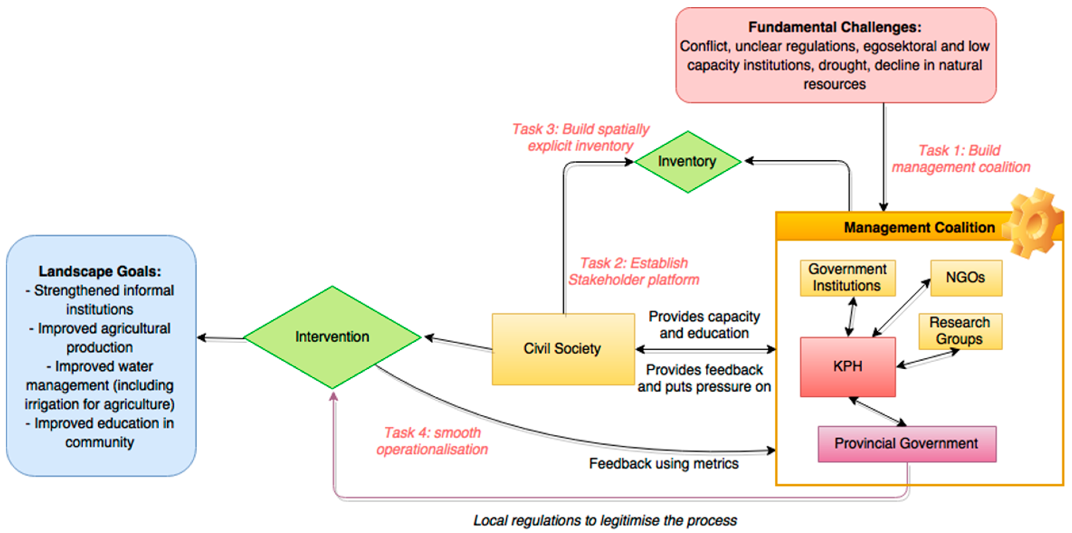
Figure 3 depicts the theory of change developed in our workshop. Civil society is positioned as the main agent driving change. The management coalition consists of active organizations, the KPH, and the district government. As one of the few cross-sectoral agencies, the KPH is responsible for coordinating the process; organizing the management coalition and building an alliance between the district government and other institutions. A coordinated management coalition is intended to raise the capacity of civil society members to make informed decisions. This arrangement creates feedback loops and ensures continued stakeholder engagement. Citizen groups have a responsibility to contribute towards spatially explicit inventories of the natural, social, physical, human, and financial assets of the landscape, giving them the power to identify appropriate institutions and build an appropriate platform for negotiations amongst stakeholders. The inventories would be centrally curated by the KPH, who would make inventories transparent and accessible to all stakeholders. Collaboration between the management coalition and civil society leads to interventions that are legitimized by the district government and local regulations. Participants felt it was important to ensure that these interventions were coordinated across multiple scales, including a national policy to harmonize all land allocation maps known as the “one map” initiative and make this the basis for provincial development plans. The KPH would like to see forests restored to benefit local people via profit-sharing schemes. Informants from nearby villages recognized the value of tree cover but at present obtain more benefits when they clear land for crops. Young local NGO members look forward to increased tourism, stronger outside connections and technological modernization of the landscape. Through building a theory of change, differing views converged into an overarching goal: improved landscape and livelihoods, with multiple outcomes and impacts. Priority outcomes were improvements in incomes, agricultural productivity, education, and coordinating institutions. Outcome goals are linked and there are positive feedbacks between them. The theory of change represents a long-term adaptive process. Process and outcome metrics will be necessary to evaluate progress [32].
5. Discussion
Our results show that unclear regulations and tenure conflicts encourage people of East Lombok to exploit resources opportunistically and this leads to degradation of their environment. Drought, floods, diminishing water supply and forest degradation are key concerns for all actors but institutions and institutional arrangements lack the incentives, power and capacity to deal with these cross-sectoral issues. The actor network analysis and theory of change in this case study support the positioning of the KPH as a bridging organization to foster cross-institutional collaboration and strengthen landscape governance [28]. Yet persistent and fundamental governance challenges of the East Lombok landscape require asking what practical actions can be taken in the short and long-term. If East Rinjani KPH were the responsible institution for coordinating landscape governance, how could it direct change and lead progress towards effective polycentric governance?
Current priorities for the East Rinjani KPH are; (1) building institutional and civil support for forest landscape management; (2) developing incentives for community engagement and; (3) developing locally appropriate solutions that address social-ecological challenges. The theory of change developed at the workshop identifies pathways for the KPH to achieve effective landscape governance, outlining key tasks that would enable the East Rinjani KPH to build capacity for effective polycentric governance while making progress towards these objectives. Understanding landscape dynamics and the complex arrangements that either enhance or inhibit sustainable management are vital to effectively implement key KPH activities, such as forest restoration [15]. By focusing on strengthening cross-institutional communication and information sharing, the East Rinjani KPH can improve the processes that shape forest management decisions [29]. A growing body of literature demonstrates the contribution of polycentric governance to sustainable forest management [29,54,55]. Acknowledging the complexity and the difficulties of transforming governance, the four steps below focus on preparing the system for change, including building support among different actors for integrated landscape management. We deduced the steps from the results of this case and they recapitulate the strategies developed by Olsson et al. [56] for transforming governance in social-ecological systems. The theory of change (Figure 3) describes the explicit change mechanisms linking the tasks below to the landscape challenges and goals identified during the workshop.
5.1. Building a Management Coalition
The first task described in the theory of change is building the management coalition. Currently in East Lombok, multiple actors are working in the landscape with inadequate coordination and collaboration. Climate change research organizations, NGOs, agricultural extension programs, and community development groups work with local communities but operate in silos with different methods, budgets, and targets. The priority for the KPH should therefore be mapping actors within the landscape and using stakeholder analysis or social network analysis procedures [57]. Stakeholder analysis involves identifying key actors in the landscape and assessing their power, influence, and legitimacy [58]. Understanding these characteristics should enable the KPH to establish social networks and gain knowledge of the social-ecological relationships within East Lombok. Multiple methods of stakeholder analysis exist and can be applied in this context.
5.2. Establish a Platform for Stakeholder Dialogue
Once a management coalition is established, the KPH should build a platform for dialogue with civil society to motivate engagement and incentive for landscape management. Frequent dialogue between stakeholders will help build trust, develop norms, and identify shared objectives that can be achieved through improved landscape governance. The quality of stakeholder participation and collective decision-making will depend on the nature of the process [59,60]. Outspoken and engaged members of civil society can mask power differentials and the needs of marginalized groups. As process facilitator, the KPH will be responsible for ensuring different groups are represented and their voices heard. We agree with Reed [59] that long-term success of stakeholder engagement requires the institutionally embedding of participation into governance processes. The methods to achieve effective stakeholder participation in East Lombok will need to take into account local context and stakeholder dynamics, including the diverse range of NGO activities and goals. If the KPH can create a governance culture that embraces feedback between institutions and civil society they will have made immense progress towards the landscape goals depicted in Figure 3.
5.3. Establish a Spatially Explicit Inventory
Effective polycentric governance hinges on how well institutions and responsibilities are matched to the social-ecological components of the landscape [29]. Currently, multiple interventions and studies are being undertaken in East Lombok but there is no mechanism for sharing knowledge. Building a spatially explicitly inventory of all attributes of the landscape, including data on the stocks and dynamics of human, social, natural, financial, and physical assets, can help inform management interventions [32]. Considering the KPH mandate, we argue that it is well-placed to centrally curate this inventory, and facilitate co-learning with the full range of stakeholders. Curating the knowledge inventory should involve co-generating and maintaining knowledge of ecosystem dynamics with the local community and other actors in the landscape. Participatory activities and visualization techniques can elucidate local desires and values using informal inexpensive processes [46]. In addition, previous research and development projects could provide useful contextual data that is otherwise unattainable [36,39,61,62]. If motivated by the KPH, multiple actors can contribute to the knowledge inventory through citizen science [63] and information exchange, including local NGOs, water management groups, government institutions, and farmer cooperatives. The inventory can also contribute to stakeholder discussions and should be used transparently to make trade-offs explicit during decision-making processes.
5.4. Operationalize the Theory of Change
The KPH can act within its mandate to drive a collaborative process of building a theory of change for the East Lombok landscape. The theory of change would provide a comprehensive conceptual framework for how actors in the landscape perceive the key challenges and goals and their shared vision for making progress towards those goals. The KPH could then ‘direct the local context through adaptive management’, coordinating and mobilizing actions and creating incentive for continued engagement [56]. Formalizing arrangements may help to overcome institutional barriers and build durability in the process, especially if it is supported by civil society. Process metrics suggested in Sayer et al. [32] could provide a framework for measuring progress towards the improved landscape scenario. Experimentation, learning, and adaptation will be required.
5.5. Current Challenges Inhibiting Progress towards Improved Governance
The potential for the East Rinjani KPH to deliver improved forest landscape governance is limited by Indonesia’s lack of a formal legislative framework for coordinating sectoral interventions in landscapes. Planning is dominated by sectoral approaches. The KPH is legally restricted to operating inside State forest boundaries, inhibiting its capacity to take a holistic landscape approach. Current mechanisms for improving landscape governance (such as the KPH) are not sufficiently institutionalized or financially supported. East Rinjani KPH officers were very uncertain about their future. Their budget and program was unclear and apparently subject to politically imposed change. Integration between KPHs and local government, existing forest management instruments, and other sectors has not been realized. As bridging organizations, KPHs should not only be responsible for building local capacity for effective governance but also negotiating change at a higher level [56]. They need to be able to influence decision makers at provincial and central levels, managing communication and information sharing both up and down the hierarchy. In East Lombok, ambiguity over natural resource legislation means the role of the KPH in high level decision making is unclear. Overcoming barriers limiting KPH integration into forest landscape management should be the main priority for KPHs moving forward. By bridging the gap between civil society and decision-makers, East Rinjani KPH can help translate local needs into policy and action and clarify responsibilities in the landscape. The actor network map shows civil society groups are well connected to each other and to the KPH, but rarely to other government sectors. Several clusters in the network are not communicating effectively. Local government involvement (especially at the district level in Indonesia) is crucial for legitimacy and building trust among stakeholders. The KPH staff recognize that to achieve their mandate, they must first build consensus among institutions and civil society on how to achieve landscape goals. Fischer et al. [6] report that the KPH leadership sympathizes with these conclusions Indonesia-wide. While they lack control over institutional structure and budget, their capacity to implement their mandate is largely dependent on the willingness of other actors to engage. If the KPHs could facilitate a process that builds social capital between institutions and civil society they could help overcome constraints in legislation for improved landscape management.
5.6. Poverty as an Inhibitor of Nature Conservation
A second challenge inhibiting improved governance in East Lombok is the lack of incentives for managing natural resources among civil society groups. Poverty is frequently recognized as an inhibitor of forest restoration and conservation [64]. Participants at the workshop assumed that the fundamental landscape challenges and goals would be sufficient to motivate civil engagement and cross-sectoral collaboration. While the social-ecological conditions in East Lombok constitute a common concern, we contest the assumption that civil society will engage in forest landscape management without explicit and strong incentives. Andersson and Ostrom [65], have shown that local actors often bear a substantial part of the costs of environmental conservation while receiving only a small part of the benefits. Our observations in East Lombok were that households prioritize meeting daily food needs over long-term conservation. Changing forest utilization arrangements and access rights have created distrust among the community. Farmers would rather harvest timber illegally now than rely on an agreement that might provide them with income in five years’ time. While improved landscape governance arrangements are likely to contribute to forest management, it is less clear how these arrangements will address key concerns of civil society such as education and water security. Interventions requiring buy-in from local communities should be matched to local needs and motivations [30]. To inspire commitment for improved landscape governance, East Rinjani KPH will need to support interventions that benefit local resource users. Local communities may be unwilling to sacrifice short-term gains for long-term wins, especially if their livelihoods are not secure.
The KPH will have to reflect upon and adapt its long- and short-term management plans so that they adequately address the root problems in the landscape. It will have to learn from and reconsider its interventions so they effectively meet community needs while achieving environmental goals. Interventions that address underlying problems in the East Lombok landscape such as flooding, water scarcity, or agricultural productivity are likely to deliver stronger incentives for participation and ultimately lead to better conservation outcomes.
Progress will require restructuring institutions and responsibilities to improve efficiency and effectiveness. The KPH will need to manage egosektoral agendas and find a common concern entry point [66] to reconcile conflicting objectives. Better knowledge of drivers of change and interlinked agricultural, hydrological, and ecological processes would make assumptions about optimal land use arrangements and stakeholder objectives explicit.
6. Conclusions
Demands on natural resources in Indonesia are growing while governance arrangements to resolve competing claims are weak. Current trends are toward recognizing the importance of functional multi-level and polycentric governance; however, implementing a systems approach to natural resource management will require overcoming significant institutional and practical barriers. Our study concludes that Forest Management Units can fulfill their role as bridging organizations for improving forest landscape governance in Indonesia by strengthening institutional relationships and incentives for stakeholder engagement. We recognize that currently KPHs have a restricted mandate and cannot operate outside State forest boundaries. Incentives for KPHs to include non-State forest land within forest landscape management could improve their capacity to achieve their mandate. In complex forested landscapes, legislation alone is unlikely to solve problems—better management must carry that burden. In East Lombok, we find building social capital for effective polycentric governance appears to offer more hope for progress than broad-based institutional change. Progress can emerge from social networks and interactions between private, public, and civil society groups outside formal government structures [67]. Communication and feedback need to flow vertically and horizontally through hierarchal structures. However, meaningful progress towards integrating conservation and development in East Lombok will also require change at higher political levels. Indonesia suffers from a multitude of natural resource conflicts, many of which cannot be resolved at the local scale. Despite numerous poverty and climate change adaptation projects from international NGOs and governments, East Lombok still lacks a coordinated and contextualized approach to dealing with crosscutting issues [39]. We attribute much of this failure to the challenges of dealing with complex systems. Government agencies and NGOs simply do not have the time, budget, or resources to tackle challenging problems [68]. Meeting East Lombok’s landscape goals of strengthened institutions, forest production, water management and community capacity will require legislative and government support. The needs of farmers and communities should be addressed in provincial development plans and accounted for in government expenditure. For Indonesian KPHs and other institutions implementing forest landscape management, relatively simple processes such as formulating stakeholder networks and building a platform for engagement can enable progress towards effective landscape governance. These are short-term actions that should lay down the foundations for long-term landscape transformations. Further research demonstrating the effectiveness of practical ways for dealing with complex systems is required to strengthen evidence-based decision making. Coordinating landscape governance is resource-intensive and requires strong leadership and adaptive management. Currently, KPHs may lack the capabilities to transform governance in forest landscapes but they can make progress by catalyzing cross-sectoral collaboration and exploiting civil society’s commitment to reconciling landscape-level social-ecological conflicts.
Acknowledgments
We thank our colleagues and students at University of Mataram for continually hosting our visits to Lombok with especial thanks to Imam Bachtiar and Suwardji. We are grateful to numerous organisations and institutions that informed our research, especially the East Rinjani Forest Management Unit. Thank you to Aminuddin Munir, Mashlahatul Umami, Bisrul Khofi and Hesty Martiova Artatia for your support and sharing. Special thanks to Zainal Arifin, Suhirman, Jumaher, Abdurrahman Sembahulun, Dinas Kelautan dan Perikanan Kab. Lombok Timur and numerous NGO colleagues Farabisina, LMNLU, WWF, WCS, LPSDM, CDC Sembalun, KKLD, ADBMI, Samanta and Santiri. We thank our workshop participants and the communities who hosted us in Sembalun, Sugian, Sambelia, Dara Kunci and Dadap of East Lombok for sharing their knowledge and experiences.
Author Contributions
Y.S., H.S.L. and A.K.B. facilitated field workshops; C.M., D.A.S., J.S., R.A.R. and J.D.L. analyzed the data; R.A.R. and J.D.L. wrote the paper. H.S.L., A.K.B., C.M., D.A.S. and J.S. contributed edits and comments to subsequent drafts.
Conflicts of Interest
The authors declare no conflict of interest
References
- Sahide, M.A.K.; Supratman, S.; Maryudi, A.; Kim, Y.S.; Giessen, L. Decentralisation policy as recentralisation strategy: Forest management units and community forestry in Indonesia. Int. For. Rev. 2016, 18, 78–95. [Google Scholar] [CrossRef]
- Riggs, R.A.; Sayer, J.; Margules, C.; Boedhihartono, A.K.; Langston, J.D.; Sutanto, H. Forest tenure and conflict in Indonesia: Contested rights in Rempek Village, Lombok. Land Use Policy 2016, 57, 241–249. [Google Scholar] [CrossRef]
- Ravenel, R.M. Community-based logging and de facto decentralization: Illegal logging in the Gunung Palung area of West Kalimantan, Indonesia. J. Sustain. For. 2004, 19, 213–237. [Google Scholar] [CrossRef]
- Kartodihardjo, H.; Nugroho, B.; Putro, H. Forest Management Unit Development—Concept, Legislation and Implementation; Ministry of Forestry: Jakarta, Indonesia, 2011. [Google Scholar]
- Ota, M. Can Forest Management Units Improve the Management of State Forests in Indonesia’s Outer Islands? Institutional Analysis and Case Studies from Lampung Province of Sumatra. Int. For. Rev. 2015, 17, 76–85. [Google Scholar] [CrossRef]
- Fisher, L.A.; Kim, Y.S.; Latifah, S.; Mukarom, M. Managing Forest Conflicts: Perspectives of Indonesia’s Forest Management Unit Directors. For. Soc. 2017, 1, 8–26. [Google Scholar] [CrossRef]
- Ruhimat, I.S. Implementasi kebijakan Kesatuan Pengelolaan Hutan (KPH) Di Kabupaten Banjar. J. Anal. Kebijak. Kehutan. 2010, 7, 169–178. [Google Scholar] [CrossRef]
- Suwarno, E.; Kartodihardjo, H.; Kolopaking, L.M.; Soedomo, S. The Use of Ostrom’s Concept on Rules-in-Use in the Analysis of Regulation of Forest Management Unit Formation. J. Anal. Kebijak. Kehutan. 2016, 12, 13–26. [Google Scholar]
- Nugroho, B.; Kartodihardjo, H.; Nurrochmat, D.R. Formulasi Strategi Komunikasi Kebijakan Kehutanan: Kasus Pembangunan Kesatuan Pengelolaan Hutan; Bogor Agricultural University: Bogor, Indonesia, 2015. [Google Scholar]
- Suwarno, E.; Kartodihardjo, H.; Kolopaking, L.M.; Sudarsono, S. Institutional Obstacles on the Development of Forest Management Unit: The Case of Indonesian Tasik Besar Serkap. Am. J. Environ. Prot. 2014, 2, 41–50. [Google Scholar]
- MacDicken, K.G. Global forest resources assessment 2015: What, why and how? For. Ecol. Manag. 2015, 352, 3–8. [Google Scholar] [CrossRef]
- Sloan, S.; Sayer, J.A. Forest Resources Assessment of 2015 shows positive global trends but forest loss and degradation persist in poor tropical countries. For. Ecol. Manag. 2015, 352, 134–145. [Google Scholar] [CrossRef]
- Folke, C.; Hahn, T.; Olsson, P.; Norberg, J. Adaptive governance of social-ecological systems. Annu. Rev. Environ. Resour. 2005, 30, 441–473. [Google Scholar] [CrossRef]
- Berkes, F. Evolution of co-management: Role of knowledge generation, bridging organizations and social learning. J. Environ. Manag. 2009, 90, 1692–1702. [Google Scholar] [CrossRef] [PubMed]
- Van Oosten, C.; Gunarso, P.; Koesoetjahjo, I.; Wiersum, F. Governing forest landscape restoration: Cases from Indonesia. Forests 2014, 5, 1143–1162. [Google Scholar] [CrossRef]
- Westerink, J.; Opdam, P.; Van Rooij, S.; Steingröver, E. Landscape services as boundary concept in landscape governance: Building social capital in collaboration and adapting the landscape. Land Use Policy 2017, 60, 408–418. [Google Scholar] [CrossRef]
- Peraturan Presiden Republik Indonesia. Kedudukan, Tugas, dan Fungsi Kementerian Negara (24). 2010. Available online: http://kelembagaan.ristekdikti.go.id/wp-content/uploads/2017/01/nomor-24-1.pdf (accessed on 15 December 2017). (In Indonesian).
- Astuti, R.; McGregor, A. Indigenous land claims or green grabs? Inclusions and exclusions within forest carbon politics in Indonesia. J. Peasant Stud. 2017, 44, 445–466. [Google Scholar] [CrossRef]
- Contreras-Hermosilla, A.; Fay, C.; Effendi, E. Strengthening Forest Management in Indonesia through Land Tenure Reform: Issues and Framework for Action; Forest Trends: Washington, DC, USA, 2005. [Google Scholar]
- Safitri, M.; Ramdhaniaty, N.; Arizona, Y.; Abimanyu, G.; Muhajir, M.; Arsyad, I. Legality and Justice in the Establishment of Forest Zones in Indonesia Policy Paper 2/2015. 2015. Available online: http://rightsandresources.org/wp-content/uploads/Epistema-Policy-Paper-2-2015-ENG.pdf (accessed on 6 December 2016).
- Barrett, S. Coordination vs. voluntarism and enforcement in sustaining international environmental cooperation. Proc. Natl. Acad. Sci. USA 2016, 113, 14515–14522. [Google Scholar] [CrossRef] [PubMed]
- Sayer, J.; Chokkalingam, U.; Poulsen, J. The restoration of forest biodiversity and ecological values. For. Ecol. Manag. 2004, 201, 3–11. [Google Scholar] [CrossRef]
- Sahide, M.A.K.; Giessen, L. The fragmented land use administration in Indonesia—Analysing bureaucratic responsibilities influencing tropical rainforest transformation systems. Land Use Policy 2015, 43, 96–110. [Google Scholar] [CrossRef]
- Gallemore, C.; Harianson, R.; Moeliono, M. Discursive barriers and cross-scale forest governance in Central Kalimantan, Indonesia. Ecol. Soc. 2014, 19. [Google Scholar] [CrossRef]
- Moeliono, M.; Gallemore, C.; Santoso, L.; Brockhaus, M.; Di Gregorio, M. Information networks and power: Confronting the “wicked problem” of REDD+ in Indonesia. Ecol. Soc. 2014, 19. [Google Scholar] [CrossRef]
- Wibowo, A.; Giessen, L. Absolute and relative power gains among state agencies in forest-related land use politics: The Ministry of Forestry and its competitors in the REDD+ Programme and the One Map Policy in Indonesia. Land Use Policy 2015, 49, 131–141. [Google Scholar] [CrossRef]
- Kim, Y.-S.; Bae, J.S.; Fisher, L.A.; Latifah, S.; Afifi, M.; Lee, S.M.; Kim, I.A. Indonesia’s Forest Management Units: Effective intermediaries in REDD + implementation? For. Policy Econ. 2016, 62, 69–77. [Google Scholar] [CrossRef]
- Armitage, D.; Plummer, R. Adapting and transforming: Governance for navigating change. In Adaptive Capacity and Environmental Governance; Springer: Berlin/Heidelberg, Germany, 2010; pp. 287–302. [Google Scholar]
- Nagendra, H.; Ostrom, E. Polycentric governance of multifunctional forested landscapes. Int. J. Commons 2012, 6, 104–133. [Google Scholar] [CrossRef]
- Olsson, P.; Bodin, Ö.; Folke, C. Building transformative capacity for ecosystem stewardship in social-ecological systems. In Adaptive Capacity and Environmental Governance; Springer: Berlin/Heidelberg, Germany, 2010; pp. 263–285. [Google Scholar]
- Weiss, C.H. Nothing as practical as good theory: Exploring theory-based evaluation for comprehensive community initiatives for children and families. New Approaches Eval. Community Initiat. Concepts Methods Context. 1995, 1, 65–92. [Google Scholar]
- Sayer, J.; Margules, C.; Boedhihartono, A.K.; Sunderland, T.; Langston, J.D.; Reed, J.; Riggs, R.; Buck, L.E.; Campbell, B.M.; Kusters, K.; et al. Measuring the effectiveness of landscape approaches to conservation and development. Sustain. Sci. 2017, 12, 465–476. [Google Scholar] [CrossRef]
- BPS. Statistics Nusa Tenggara Barat. Badan Pusat Statistik 2016. Available online: http://ntb.bps.go.id/ (accessed on 8 February 2017).
- Moerwanto, A.S. Research strategy and water resources development for supporting sustainable water resources management. In Proceedings of the 10th National Science Congress, Jakarta, Indonesia, 8–10 November 2011. (In Indonesian Language). [Google Scholar]
- Sjah, T.; Baldwin, C. Options for future effective water management in Lombok: A multi-level nested framework. J. Hydrol. 2014, 519, 2448–2455. [Google Scholar] [CrossRef]
- Kim, C. Land use classification and land use change analysis using satellite images in Lombok Island, Indonesia. For. Sci. Technol. 2016, 12, 183–191. [Google Scholar] [CrossRef]
- Monk, K.; De Fretes, Y.; Reksodiharjo-Lilley, G. Ecology of Nusa Tenggara and Maluka; Tuttle Publishing: Clarendon, VT, USA, 2013; Volume 5. [Google Scholar]
- Bae, J.S.; Kim, C.; Kim, Y.S.; Latifah, S.; Afifi, M.; Fisher, L.A.; Lee, S.M.; Kim, I.A.; Kang, J.; Kim, R.; et al. Opportunities for Implementing REDD+ to Enhance Sustainable Forest Management and Improve Livelihoods in Lombok, NTB, Indonesia; CIFOR: Bogor, Indonesia, 2014; Volume 151. [Google Scholar]
- Butler, J.; Suadnya, W.; Puspadi, K.; Sutaryono, Y.; Wise, R.M.; Skewes, T.D.; Kirono, D.; Bohensky, E.L.; Handayani, T.; Habibi, P.; et al. Framing the application of adaptation pathways for rural livelihoods and global change in eastern Indonesian islands. Glob. Environ. Chang. 2014, 28, 368–382. [Google Scholar] [CrossRef]
- NTB Forest Agency. NTB Forest Agency Statistics Year 2011; Nusa Tenggara Barat Provincial Forest Agency: Mataram, Indonesia, 2012. [Google Scholar]
- Ministry of Environment and Forestry. Ministry of Environment and Forestry Statistics 2014; Data and Information Centre, Ministry of Environment and Forestry Indonesia: Jakarta, Indonesia, 2015. [Google Scholar]
- Prasetyo, F.A.; Suwarno, A.; Purwanto; Hakim, R. Making policies work for payment for environmental services (PES): An evaluation of the experience of formulating conservation policies in districts of Indonesia. J. Sustain. For. 2009, 28, 415–433. [Google Scholar] [CrossRef]
- Klock, J.; Sjah, T. (Eds.) Approaches and constraints to urban water management in Lombok, Indonesia. In Water Management in Lombok, Indonesia: Challenges and Solutions; Mataram University Press: Mataram, Indonesia, 2007. [Google Scholar]
- KPH Rinjani Timur. Balai KPH Rinjani Timur. 2015. Available online: http://rinjanitimur.blogspot.com.au/p/tentang-kami.html (accessed on 28 March 2017).
- Brondizio, E. Interdisciplinarity as Collaborate Problem Framing. 2017. Available online: http://items.ssrc.org/interdisciplinarity-as-collaborative-problem-framing/ (accessed on 15 December 2017).
- Boedhihartono, A.K. Visualizing Sustainable Landscapes: Understanding and Negotiating Conservation and Development Trade-Offs Using Visual Techniques; IUCN: Gland, Switzerland, 2012. [Google Scholar]
- Chambers, R. Exploring the cogeneration of knowledge: Critical reflections on PRA and CLTS. In Into the Unknown: Explorations in Development Practice; Practical Action Publishing: Bourton, UK, 2014. [Google Scholar]
- Van Noordwijk, M.; Minang, P.A.; Freeman, O.E.; Mbow, C.; de Leeuw, J. The future of landscape approaches: Interacting theories of place and change. In Climate-Smart Landscapes: Multifunctionality in Practice; World Agroforestry Centre: Nairobi, Kenya, 2015. [Google Scholar]
- Latour, B. Reassembling the Social: An Introduction to Actor-Network-Theory; Oxford University Press: Oxford, UK, 2005. [Google Scholar]
- Khokhar, D. Gephi Cookbook; Packt Publishing Ltd.: Birmingham, UK, 2015. [Google Scholar]
- Stein, D.; Valters, C. Understanding Theory of Change in International Development; The Justice and Security Research Programme: London, UK, 2012. [Google Scholar]
- Retolaza Eguren, I. Theory of Change: A thinking and Action Approach to Navigate in the Complexity of Social Change Processes; Democratic Dialogue Regional Project; The Regional Centre for Latin America and the Caribbean, UNDP and Humanistic Institute for Development Cooperation (HIVOS): Panama City, Panama, 2011. [Google Scholar]
- Fauzi, A.; Anna, Z. The complexity of the institution of payment for environmental services: A case study of two Indonesian PES schemes. Ecosyst. Serv. 2013, 6, 54–63. [Google Scholar] [CrossRef]
- Elbakidze, M.; Angelstam, P.; Sandström, C.; Axelsson, R. Multi-stakeholder collaboration in Russian and Swedish model forest initiatives: Adaptive governance toward sustainable forest management? Ecol. Soc. 2010, 15, 14. [Google Scholar] [CrossRef]
- Bixler, R.P. From community forest management to polycentric governance: Assessing evidence from the bottom up. Soc. Nat. Res. 2014, 27, 155–169. [Google Scholar] [CrossRef]
- Olsson, P.; Folke, C.; Hahn, T. Social-ecological transformation for ecosystem management: The development of adaptive co-management of a wetland landscape in southern Sweden. Ecol. Soc. 2004, 9, 2. [Google Scholar] [CrossRef]
- Prell, C.; Hubacek, K.; Reed, M. Stakeholder analysis and social network analysis in natural resource management. Soc. Nat. Res. 2009, 22, 501–518. [Google Scholar] [CrossRef]
- Mitchell, R.K.; Agle, B.R.; Wood, D.J. Toward a theory of stakeholder identification and salience: Defining the principle of who and what really counts. Acad. Manag. Rev. 1997, 22, 853–886. [Google Scholar]
- Reed, M.S. Stakeholder participation for environmental management: A literature review. Biol. Conserv. 2008, 141, 2417–2431. [Google Scholar] [CrossRef]
- Kusters, K.; Buck, L.; de Graaf, M.; Minang, P.; van Oosten, C.; Zagt, R. Participatory Planning, Monitoring and Evaluation of Multi-Stakeholder Platforms in Integrated Landscape Initiatives. Environ. Manag. 2017, 1–12. Available online: https://doi.org/10.1007/s00267-017-0847-y (accessed on 15 December 2017).
- Rochester, W.A.; Skewes, T.D.; Suadnya, I.W.; Butler, J.R.; Lyne, V.D.; Handayani, T.; Habibi, P.; Cokrowati, N. A typology of natural resource use for livelihood impact assessments in Nusa Tenggara Barat Province, Indonesia. Clim. Risk Manag. 2016, 12, 59–68. [Google Scholar] [CrossRef]
- Kirono, D.G.; Butler, J.R.; McGregor, J.L.; Ripaldi, A.; Katzfey, J.; Nguyen, K. Historical and future seasonal rainfall variability in Nusa Tenggara Barat Province, Indonesia: Implications for the agriculture and water sectors. Clim. Risk Manag. 2016, 12, 45–58. [Google Scholar] [CrossRef]
- Sayer, J.; Margules, C.; Bohnet, I.; Boedhihartono, A.; Pierce, R.; Dale, A.; Andrews, K. The Role of Citizen Science in Landscape and Seascape Approaches to Integrating Conservation and Development. Land 2015, 4, 1200–1212. [Google Scholar] [CrossRef]
- Sandker, M.; Ruiz-Perez, M.; Campbell, B.M. Trade-offs between biodiversity conservation and economic development in five tropical forest landscapes. Environ. Manag. 2012, 50, 633–644. [Google Scholar] [CrossRef] [PubMed]
- Andersson, K.P.; Ostrom, E. Analyzing decentralized resource regimes from a polycentric perspective. Policy Sci. 2008, 41, 71–93. [Google Scholar] [CrossRef]
- Sayer, J.; Sunderland, T.; Ghazoul, J.; Pfund, J.L.; Sheil, D.; Meijaard, E.; Venter, M.; Boedhihartono, A.K.; Day, M.; Garcia, C.; et al. Ten principles for a landscape approach to reconciling agriculture, conservation, and other competing land uses. Proc. Natl. Acad. Sci. USA 2013, 110, 8349–8356. [Google Scholar] [CrossRef] [PubMed]
- Lebel, L.; Anderies, J.; Campbell, B.; Folke, C.; Hatfield-Dodds, S.; Hughes, T.; Wilson, J. Governance and the capacity to manage resilience in regional social-ecological systems. Ecol. Soc. 2006, 11, 19. [Google Scholar] [CrossRef]
- Balint, P.J.; Stewart, R.E.; Desai, A.; Walters, L.C. Wicked Environmental Problems: Managing Uncertainty and Conflict; Island Press: Washington, DC, USA, 2011. [Google Scholar]
Figure 1.
East Rinjani Forest Management Units (Kesatuan Pengelolaan Hutan or KPH). It is centered on the large forest block at Mt. Rinjani (1). But there are outlying fragments at Gong (8) Petandakan (9) Kedatu (10) and Rebanbela (11) and officially includes the islands of Gili Lawang, Gili Sulat, and Gili Petagan (14), and a large outlier on the south-east coast, Sekaroh (15). Adapted from [44].

Figure 2.
Actor Network. Showing the lack of connectivity between civil society organizations and government actors, apart from KPH, or with the main private sector actor.
Figure 2.
Actor Network. Showing the lack of connectivity between civil society organizations and government actors, apart from KPH, or with the main private sector actor.

Figure 3.
Theory of Change for East Lombok landscape.


Table 1.
State forest area and function in East Lombok.
| Forest Function | Hectares |
|---|---|
| Conservation (Rinjani National Park) | 27,445.00 |
| KPHL Total Forest | 37,589 |
Protected (ha)
| 31,987 320 50 |
| Limited production (ha) | 0 |
Production (ha)
| 5602 420 285 2000 |
| Total forest Area (ha) | 64,508.67 |
| Percentage of Lombok total forest | 39.5% |
Table 2.
Description of methodological approach, tools and contribution to results.
| Approach | Method | Outcome |
|---|---|---|
| Collaborative problem framing | Preliminary stakeholder consultation: facilitated discussions with University of Mataram, East Rinjani KPH, West Rinjani KPH community forestry leaders, East Lombok Planning Agency, local government institutions and NGOs. Actor network scoping exercise performed | Preliminary diagnosis of forest landscape governance challenges |
| Participatory Rural Appraisal | SWOT Analysis: Analysis of community perceived strengths, weakness, opportunities, threats of forest-partnership scheme implemented by East Rinjani KPH | Local perspectives on forest management and incentives for engagement |
| Historical Timeline: Built in the villages of Sugian and Sembalun with two village Adat (customary) elders | Understand drivers of change, key events | |
| Knowledge cogeneration | Participatory systems modelling: Exploration of scenarios using Vensim software (Ventana Systems Vensim Profession 6.4b) | Facilitate discussion on synergies and trade-offs in forest management |
| Actor Network Analysis: Mapping of actors and power relations, processed in Gephi 0.9.1 | Understand existing governance arrangements | |
| Theory of Change: Identification of landscape challenges, goals, key actors and process for change | Identify the potential contribution of East Rinjani KPH to forest landscape governance |
Table 3.
Historical Events in East Lombok (based on key informant interviews in Sambelia and Sembalun sub-districts).
Table 3.
Historical Events in East Lombok (based on key informant interviews in Sambelia and Sembalun sub-districts).
| Year | Event |
|---|---|
| 1257 | Mt. Rinjani volcanic eruption (Samalas volcano), destroying forests in significant parts of Lombok, Bali and western Sumbawa |
| 1815 | Mt. Tambora volcanic eruption, taking the lives of over 80,000 people (located on Sumbawa) |
| 1929–1945 | Delineation of forest boundaries under Dutch colonial rule |
| 1945 | Coffee cultivation in Sembalun began, mainly for local consumption |
| 1960s | Village elder recalls much more tree cover on slopes around Sembalun |
| 1972 | Transmigration program brought people to Sambelia for timber exploitation in State forest area |
| 1975 | Road network expansion throughout East Lombok |
| 1977 | Transmigration program relocated farmers from Central Lombok to Sambelia, providing each household with 2 ha of land |
| 1979 | Rinjani Nature Reserve established. Local villagers drained lake near Sembalun for agriculture |
| 1982 | Road to Sambelia district built |
| 1985 | Garlic cultivation replaced coffee plantations around Mt. Rinjani, President Suharto visited Sembalun to encourage garlic as the icon product of the region |
| 1986 | Department of Tourism established |
| 1988 | PT Sembalun Kusuma Emas (SKE) establish garlic plantation in Sembalun (active until 1998) |
| 1989 | Timber concession in Sambelia |
| 1990 | Mt. Rinjani National Park established Interviewees observed natural spring depletion and increase in illegal logging and fires |
| 1992 | MoF defined forest boundaries (KPH Interview) Timber concession owners begin forest rehabilitation program in Sambelia to curb deforestation |
| 1995 | Farmers diversify into potatoes, onions, carrots, chili, and other vegetables in Sembalun |
| 1997 | El Nino drought affecting agricultural yields and environmental degradation provoking fires The Ministry of Agriculture establishes agroforestry program in Sambelia district (within State forest) |
| 1999 | Decentralisation—The Regency Forest Department (Dinas Kehutanan Kabupaten) gained jurisdiction over production and protected forests, while conservation forests remained under the authority of the national government Water management institution Balai Wilayah Sungai (BWS) began working on water issues in Sambelia |
| 2000 | Community forestry (HKM) established in Sambelia, 520 people and 420 ha |
| 2002 | PT Sampoerna Agro established greenhouse system in Sembalun for tomatoes, peppers, lettuce, broccoli, strawberries, and grapes for export. |
| 2006 | Landslide caused flash flooding in Sembalun and Sambelia. Large areas containing houses and crops were severely damaged. Floods raised environmental awareness among communities and were attributed to illegal logging |
| 2008 | Community forestry (HKM) established in Sapit village, 715 households and 450 ha |
| 2010/2012 | Severe floods on Eastern slopes of Mt. Rinjani affecting Sambelia |
| 2012 | East Lombok establish KPHL Rinjani Timur under the district forestry department |
| 2013 | KPH commences rehabilitation program in protection forest, planting cinnamon, candlenut, timber trees |
| 2014 | KPH redefined State forest boundaries, reducing the area where settlement existed (KPH interviewee) |
| 2015 | KPH engages local community in forest rehabilitation and commences Kemitraan program |
Table 4.
East Rinjani Kemitraan profit sharing scheme.
| Protection Forest | Production Forest | |
|---|---|---|
| Village | Mekar Sari | Sugian |
| Year commenced | 2013 | 2015 |
| Current size (2016) (ha) | 320 | 285 |
| Number of people involved | Approx. 470 | Approx. 200 |
| Land status | Degraded rainforest (approx. 40% planted with agroforestry crops) | Degraded dry deciduous forest with minimal tree cover (approx. 75% rice paddy/maize) |
| Cropping arrangement | Divided into blocks, each member has one block, no more than 2 ha. | |
| Main crops planted in rehabilitation program | Avocado Durian Jackfruit Candlenut Cinnamon Tamarind Ginger Mahogany (timber tree) Rajumas (timber tree) Pulai (timber tree) | Sengon (timber tree) Gmelina (timber tree) |
| Profit sharing arrangement | 40% earnings to KPH 60% earnings to members Members pay 1,500,000 annually to village | *39% earnings to KPH 60% earnings to members 1% earnings to village office |
| Future expansion | <9616.77 ha | <2991 ha |
© 2018 by the authors. Licensee MDPI, Basel, Switzerland. This article is an open access article distributed under the terms and conditions of the Creative Commons Attribution (CC BY) license (http://creativecommons.org/licenses/by/4.0/).
Share and Cite
MDPI and ACS Style
Riggs, R.A.; Langston, J.D.; Margules, C.; Boedhihartono, A.K.; Lim, H.S.; Sari, D.A.; Sururi, Y.; Sayer, J. Governance Challenges in an Eastern Indonesian Forest Landscape. Sustainability 2018, 10, 169. https://doi.org/10.3390/su10010169
AMA Style
Riggs RA, Langston JD, Margules C, Boedhihartono AK, Lim HS, Sari DA, Sururi Y, Sayer J. Governance Challenges in an Eastern Indonesian Forest Landscape. Sustainability. 2018; 10(1):169. https://doi.org/10.3390/su10010169
Chicago/Turabian StyleRiggs, Rebecca A., James D. Langston, Chris Margules, Agni Klintuni Boedhihartono, Han She Lim, Dwi Amalia Sari, Yazid Sururi, and Jeffrey Sayer. 2018. "Governance Challenges in an Eastern Indonesian Forest Landscape" Sustainability 10, no. 1: 169. https://doi.org/10.3390/su10010169
Note that from the first issue of 2016, this journal uses article numbers instead of page numbers. See further details here.