1. Introduction
Internet and new Web 2.0 tools are changing the way we communicate in an unprecedented way. The rising importance of communicative aspects of urban planning has been driven by participation, which through new technologies, has had an increasingly decisive role in the process of land transformation [
1]. Today the concept of governance refers to a system that establishes a new relationship between the decision-maker and the receiver making online participatory systems useful tools to inform and involve city users in a system of participatory planning.
Interest in Information Communication Technology (ICT) and in geographic information technologies (GIT) not only derives from the obvious opportunities of new technological frontiers, but also from how these instruments show urban reality and, more generally, territorial, where multi-disciplinary knowledge converges. In fact this offers the possibility of using innovative tools to put together communicative knowledge, which in an ideal scenario of participatory democracy is involved in the information, evaluation and decision making phase necessary to define parts of the project and to implement and manage urban regeneration. While today computer technology is essential to the construction of knowledge and management of the project, on the other hand it cannot standardize the processes of transformation of the territory and cannot be considered sufficient to provide continuous knowledge and management support to the territorial government. For participation to be effective, a cultural change is needed by both administrators and the people involved in the process of participation. This change involves the ability and willingness to work in a team, to define clear roles and to share information efficiently, but above all to discuss and rethink opinions and choices.
The paper is organized into three sections: the first section starts with a brief review of participation and e-participation concepts with the intent to focus on Public Participation GIS (PPGIS). The second section proposes a new way of joining the traditional approach with the participative approach. The third part of the paper illustrates a case study, conducted in Cagliari (Sardinia, Italy). Finally, the results of the case study are discussed, focusing on the integration of traditional and innovative ways of participation.
2. New Era of Participation Processes
The dominant use of new technologies is increasing the use of online media in both the public and private sector, changing patterns, relations and hierarchies of traditional processes in favor of more democratic participation. This “information explosion […] refers to the need and the opportunity to examine the subjective iterative content of the expert planning process: a maximum level of interaction in the new plans surprisingly seems to correspond to a maximum level of personal involvement and self-reflection” [
2].
However, there are several criticisms of how the digital revolution contributes to the isolation and exclusion of individuals or communities. In fact, the use of the Internet has ruined potentially direct participation, and while it has taken away some psychological aspects of a typical public debate, it has also guaranteed anonymity and therefore the freedom to express oneself by allowing an important new local channel of communication.
Over the past fifteen years there have been some problems related to the use and development of participatory online platforms in giving users an effective, efficient and pleasant system [
3,
4]. Obviously, as more research is carried out, these problems have evolved. As far as public administrations are concerned, these can be caused by participative situations where, contrary to what was planned in the preliminary phase [
5], there is no adhesion in the inclusive process; while for the citizen-user these problems regard the fact that access to the network is not evenly distributed. In fact, the system can be accessed from a wide range of devices such as computers, digital televisions, or even mobile phones, which all raise questions that research must address. There may also be usability problems or lack of transparency in information communication. All these issues are due to what is known as the digital divide [
6,
7,
8,
9].
However, it is necessary to underline that strategies for good governance of the territory cannot be supported solely by local authorities [
10]. They need the cooperation of the community through participatory strategies that pay particular attention to the quality of access to the project, encouraging issues to be raised rather than blocking access to those willing to participate.
A participatory environment is one in which the Internet and digital technology are used as systems to engage and facilitate the memorization of knowledge and information. This is especially effective if visual systems such as maps and images are used which are more easily recognized by the participants in the participation process [
11]. In a recent paper, Conroy and Gordon show that over the years e-government systems improve citizen participation opportunities [
12,
13] and consequently, thanks to the natural evolution of computing, such opportunities are becoming increasingly feasible [
14]. Citizens who feel involved in this planning process, as Murgante
et al. show in their article [
15], believe that their actions could be appraised and approved through the development of several alternative, more practical, solutions which characterize city users.
Citizens are now becoming e-citizens living in an increasingly globalized and interconnected society in which development trends critically go through multiple pathways such as e-learning, e-commerce, e-banking, e-business, e-government, e-governance, e-democracy, e-inclusion, e-communication, etc., in short, all sectors can be summarized in “e-society”.
All these systems together make up the transition from scenarios in which planning is based on consolidated, traditional models to local contexts which are instead characterized by negotiation and communication approaches modeled on the phenomena of globalization [
16], which in turn has transformed the practical tasks of the experts. This is explained by the variation in instruments of investigation and intervention, thereby increasing the specialization of these technological tools.
In the last ten years, public participation through online communication has thus become a veritable field of research, innovation and momentum based on web applications thanks to Information Communication Technology (ICT), leading to new forms of communication between citizens, planners and public authorities. When used appropriately, new generation tools could lead to a good level of efficacy not only in land management, but also in decision-making by using for example online forums, web surveys, virtual workshops and conferences, e-mail and discussion groups through online maps. The integration of Geographic Information System (GIS) and tools of public participation is one of the latest innovations in this area. The use of GIS and information technology are essential in the construction of the project, but as in some areas, such as the studied area, they cannot be considered as yet sufficient in replacing the traditional face-to-face interaction.
2.1. The Evolution of Public Participation GIS (PPGIS) and New Technologies Today
The concept of using the Geographic Information System to aid the decision-making process in order to strengthen citizen participation is a relatively new field. In fact, the intentions of the first PPGIS [
17] were to enhance the capabilities of the Geographic Information System (GIS) in order to meet and satisfy the interests of the community, while remaining aware of the potential limitations of these technologies. One of the first descriptions of these applications goes back to 1995 by Trevor M. Harris
et al. [
18] and Richard Krieg [
19]. Although they do not directly use the terminology Public Participation GIS (PPGIS), many of the applications and features they have listed are examples of “community which integrates with GIS” creating widespread participation. The terminology Public Participation GIS (PPGIS) became officially recognized a year later at the two meetings organized by the National Center for Geographic Information and Analysis (NCGIA). The PPGIS has become synonymous with the integration of local knowledge using participatory approaches which unite the face to face model (expressed through traditional meetings), with online GIS tools.
However the literature does not provide a single definition of what exactly identifies or which tools build a PPGIS. For example a publication by Sieber gives us a historical view on the argument [
20] and although it does not provide a clear definition it characterizes PPGIS as a set of practical activities from different disciplines in which the participatory planning is supported, if not improved, by the use of digital tools such as GIS maps. Geertman and Stillwell distinguish the different terminology in the literature (Participatory Geographic Information Systems—PGIS; Public Participation Geographic Information Systems—PPGIS; Participatory Planning Support Systems—PPSS; Public Participatory Planning Support Systems—PPPSS) as all having the democratic support of the local community at the decision-making stage in common [
21]. Schlossberg and Shuford [
22] present a practical example to illustrate PPGIS. They imagine and describe a matrix with different types of “public” along one axis and various types of “participation” along the other. The matrix cells which connect the various points along each axis contain the expected results of PPGIS. According to the authors, the process also works in reverse,
i.e., you start from an objective and then identify the most appropriate type of “public” and “participation”. From the second half of the nineties, participatory planning integrated with information technology produced a great deal of enthusiasm which was put into many experiences [
23,
24,
25,
26,
27,
28,
29,
30,
31] and during this period the importance of social education of the whole community emerged. At present, the development of PPGIS confirms and documents that the technology allows users to participate in the production of information, rather than remain passive consumers. In fact, the netizens can not only take advantage of interactive 3D visualization tools but also integrate digital, dynamic and interactive maps with multimedia content (for example, with ideas, comments, photos, videos, drawings, sketches and other types of data or information) associated with a precise point on the map using the potential of WebGIS. However, it is important to note that the instruments used in a given PPGIS process depend largely on the level of participation that wants to be attained. The International Association for Public Participation (IAP2) has articulated five levels of public participation—to inform, consult, involve, collaborate, empower—each successive level allows a greater impact on the overall process. Low levels of participation (inform, consult) involve the use of information tools such as interactive websites, public meetings or focus groups. Higher levels of participation (involve, collaborate, empower) allow feedback and the consequent practical implementation of community projects, through tools which go beyond a mere expression of willingness by those involved.
However, the interpretation of a PPGIS in a general framework for planning in view of ICT is essential to better understand its use. In the whirl of discussions regarding this debate it is fundamental to focus on the original objectives and resulting criteria that have led to the planning practice (these criteria can include, for example: methods and tools used, data and information circulating, respecting the schedule and working to short, medium and long-term deadlines, effects and assessments of the participatory process, etc.).
However, over the course of time it is not easy to keep up the commitment to building cooperation and adapting such practices into society. It is necessary to systematically monitor its impact through the assessment of tangible results, such as those produced by simple cooperation (agreements or actions) [
32].
2.2. PPGIS: Participation and Practices of Adaptation to New Technologies
The appeal of (or trust in) “traditional” maps (
i.e., paper, to scale, zenith, topologically correct, primarily institutional production,
etc.) is decreasing [
33] in favor of other forms which seem to respond better to new questions of “communication” and “participation”. In fact, giving the user the option of choosing the cartographic representations, means having to give up control of the representations themselves in order to obtain the required information quickly.
The static nature of traditional cartography seems to make it more rigid, less “communicative”, and unsuited to the new dynamic and hypertext languages. In recent years, the key role of GIS has emerged, forming relational data structures which are increasingly integrated with the enormous amount of information available. This is all about making advancements related to “digital culture” [
34] applied to the design and representation of the territory.
The specificity of iconographic representations of territory, and their “geometrical” design character derived from CAD, connects to information which is integrated into complex relational databases. These are managed remotely by multi-users and designed to withstand a huge amount of information ranging from alphanumeric data to pixels that make up a raster image. A new type of information infrastructure is set up which is more suitable to accommodate the needs of participatory practices, storage and data intersection.
Therefore good governance of the territory leads to dialogue and the use of new technologies, which through the Geographic Information Systems not only optimize the efficiency of transformation processes and use of the urban fabric, but project decisively models of e-government and other experiments of governance.
As a result, the practice of active involvement online cannot remain “confined to the virtual sphere of relations” between government and citizens [
35]. The online and conventional practices should result as being communicating, not contradictory and permeable. They must avoid the possibility of creating a virtualization of the participation, but such practices must also prevent the community losing interest after having learned about it as this would be that much harder to recover. One way to prevent this, other than an obvious effort by politicians to bring PPGIS processes into daily life in discreet cycles, could be a “quantitative and qualitative assessment” of the results which measure the contribution citizens want to give to ensure that decision-makers work better. You could for example create indicators to monitor during and post PPGIS process, the cultural, social, intellectual and political growth of the participants. Alternatively, estimates could be produced of the perception that those involved “support” not only their interests but also the community’s. Finally, the increased desire in wanting to participate in decision-making could be analyzed because it gives confidence and credibility to the PPGIS process. Many researchers have also tried to focus attention through a new representation of the GIS which is closer to the citizen-user. This incorporates forms of knowledge which differ from those of cartography and support quantitative and qualitative analysis, thus demonstrating that multiple disciplinary knowledge can be part of the research based on GIS, integrated into public participation [
36,
37,
38].
In public bodies, the identifying, technological, complex and multidisciplinary representation acquires a significant role in relation to the needs of communication and participation. However, as it has been repeatedly pointed out, a process of PPGIS reports to the local community using a highly complex system, which in order to obtain optimal outcomes must take into account certain determining factors, such as the outcomes and objectives of public participation, the catchment area under study, the socio-cultural and demographic characteristics of the stakeholders involved, the right tools and above all not only the timing for obtaining the results but also an assessment of the overall process in terms of impact in the short, medium and long term. All this is needed so as not to return to the previous urban scenario after the PPGIS, but that there are also effects in, e-governance and local governance policies and programs. The practices of PPGIS therefore seek to integrate the stakeholders involved, knowledge and spatial technologies with the intent to focus on factors that determine the inclusiveness, representation and the potential impact of strengthening social and technological developments in the area.
However, there is no shortage of criticism. In fact, some progressive planners [
39,
40,
41,
42,
43,
44], such as Tom Angotti, argue that “the scenario of consensual planning [...] is destined to remain a myth of an imaginary world in which there is no conflict or contradiction, where all benefit and no one loses out. A static paradise like this is impossible. Participatory planning is another myth that can obscure the real differences (between) simple passive and silent adherence to a public hearing, or the initial meetings on key issues […] and real democracy” [
45]. Although the author offers no practical guidance on how to address these obstacles, it is made clear that we must carefully consider the methods and techniques of participation, because the instrumentality of the forms of participatory planning can often influence our perceptions about the overall process and results. In this framework, the practices of PPGIS can be read as a negotiation of compromises between participation, accessibility, and democratic practices in a cross between technological and ethical—social factors.
3. Experimental Section. Introduction Case Study: The Historical Centre of Pirri Neighborhood (Cagliari, Sardinia)
It has been shown that in the last 15 years PPGIS have developed a large and growing literature that has made it difficult to deny how much Information Communication Technology (ICT), infrastructure and the action of the network have changed the relational, decision-making and representative matrix of the city and its territory. Conversely it has been equally difficult to identify, even partially any established and well-defined trends. Nevertheless, literature has shown on the one hand the usefulness [
46,
47,
48] and ease of use [
49,
50,
51] of planning support tools, on the other hand, an underuse. In particular Couclelis stresses the development of strategic planning tools to aid in creating alternative urban scenarios [
52].
However, although from a theoretical point of view the new media offers a range of opportunities to redefine community involvement through the construction of future scenarios from the different project phases (information, assessment and decision making), the practice is quite different.
The historical centre of Cagliari, made up of the five historical neighbourhoods, Castello, Marina, Stampace, Villanova, and historical centre of Pirri represents an exemplary case for the application of participative techniques supported by the ICT. In fact, the City of Cagliari, with the Detailed Plan of historical centre (DP), began testing a participatory process aimed to activate a tool that allows a significant opportunity for research and experimentation in the field.
The idea came from the assumption that it was the citizens who lived, worked or studied in the city who had the best understanding of the city’s resources and critical aspects. Participation is seen then as the active involvement of citizens in administration, even in the preparation of the DP, which is certainly one of the main tools of urban planning. The participatory process of the DP started in 2008 and ended in June 2009 with the shared adoption of strategies of the Plan. Many participatory tools were put into place in order to involve the different groups in the area (surveys, public meetings, information activities, stand leaflets, online forums, thematic groups). These varied depending on the different steps and design stages.
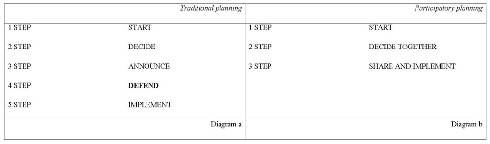
The intention of the team responsible for the DP design was to move from a traditional decision-making process (diagram a) to a participatory design (diagram b), knowing how difficult it might be to communicate both to the citizens and the public administrators the effectiveness of the participatory process (
Figure 1).
Figure 1.
Moving from a traditional decision-making process to a participatory design.
Figure 1.
Moving from a traditional decision-making process to a participatory design.
One of the reasons that led to the choice of a participatory approach was that it gave the opportunity to avoid the typical problems of a classic top-down decision-making process, namely the extension of time taken to implement the plan because of conflict of interests between stakeholders and citizens who previously were not heard, consulted or involved.
The construction of the DP started from the presentation of a preliminary information questionnaire which made it possible to understand how much residents know about their needs. In this way it was possible to actively involve the people or at least those directly involved, such as service users, tenants, property owners and retailers.
The questionnaire also served to: form a comprehensive and specific framework of the needs and expectations of the population; enable citizens to participate with critical comments and suggestions in the planning processes; assess the degree of social consensus, and finally check the possibility of involving the local community in the redevelopment and management of the services and in promoting initiatives to support local development.
From this perspective the capacity of the public administration to promote and organize a participatory process proved essential in order to result in meetings and collaboration with the institutions making the development of alternative proposals based on requests by residents possible, thus promoting the resolution of conflicts generated by the interventions.
On completion of the preliminary stage of discussion and hearing, the Administration committed itself to gathering the views of citizens for the designers to take into account in the drafting of the project. In the months in which the technicians were working on preparing the proposed plan, the WebGis was active and there was communication with technicians to inform on progress and public meetings to present plans before adopting them.
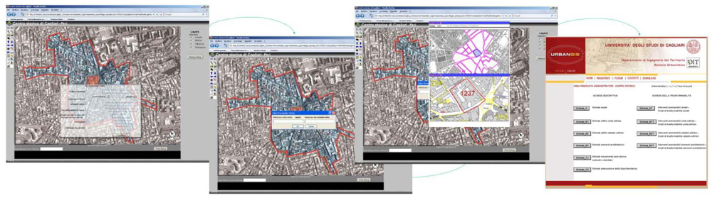
Through the use of the information technologies, users can visualize, manage and appraise the compatibility of the interventions of recovery. The activation of the WebGis has therefore as primary objective the cataloguing and the definition of the various building typo morphologies to formulate sector projects and procedures of intervention, to investigate architectural articles in relation to actual transformations and verifying them with the intervention proposals at the base of the planning tools in use.
Whatever the selected neighborhood, the information available differs between generic users and administrators. Generic users can visualize the requested information, through the reports of the alphanumeric database, or add to database of the urban transformation through an empty interface to be monitored, before it is inserted into the general system (with information related to their own residence). The administrators are able to implement the data and manage the database in order to understand the evolutions of different historical processes from the past up to today.
This has been made possible in a phase following the post—processing of the alphanumeric data, which allows links between the different types of information in the geographical referencing maps. This differentiation of information is due not only to different analytical demands, but also helps to avoid incorrect data being inserted by the generic user. These webpages are made sensitive and are correlated to the graphic representation of every block in every neighborhood which is drawn and read by the browser as a spatial entity, allowing the administrators to enter directly into the data implementation system, or to be guided through “the sea of information” (
Figure 2).
Figure 2.
The structured WebGis.
Figure 2.
The structured WebGis.
Thereafter they proceeded with the production of informative material about the construction of the detailed plan based on the elaboration of the preliminary tables. At this stage citizens could be informed on proposals being analyzed through the online platform.
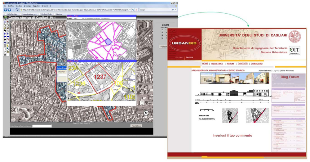
Subsequently, after the first draft of the DP by the technicians in collaboration with the Planning office, citizens were given the opportunity to submit further views and criticisms, through blogs, forums, newsgroups and discussion lists. In this way they were actually involved in the participatory process, working together with the technicians on preparing intervention strategies (
Figure 3).
Figure 3.
The structured WebGis: blog and forum page.
Figure 3.
The structured WebGis: blog and forum page.
4. Results and Discussion
The work carried out has allowed us to develop an overview of “many voices”: we had to admit that despite the efforts of the technicians in carrying out an online participatory process, the vast majority of the community involved preferred to develop their ideas in face to face meetings, in part, derailing our expectations of online participatory methodologies. In fact, only a few people showed real interest and collaborated with technicians and administration in preparing the DP, although various online participatory methodologies were tried. The use of the Internet potentially blocked direct participation and while it took away some psychological aspects which are typical in a public debate, it also guaranteed anonymity and therefore freedom of expression by giving the administration a major communication channel. On the other hand, the face-to-face meetings allowed even those who are not familiar with technology or at least prefer traditional methods of communication to participate in the process of putting together the plan.
Nevertheless those people who actively participated in the planning process underlined that the Public Administration cannot work alone, but need the contribution of the citizens themselves; people have been positioned at the centre of strategies but, more importantly, at the centre of the planning process. Participants expressed the opinion that their involvement can be strategic for the success of intervention planning.
It must be noted that a uniform standard set by a national or regional law can at best provide a rough first reference, but needs to be verified based on the real conditions and needs of the local population, which vary greatly from area to area depending on various factors related to its characteristics, particularly age and socio-economic conditions, besides environmental conditions and ways of supplying services.
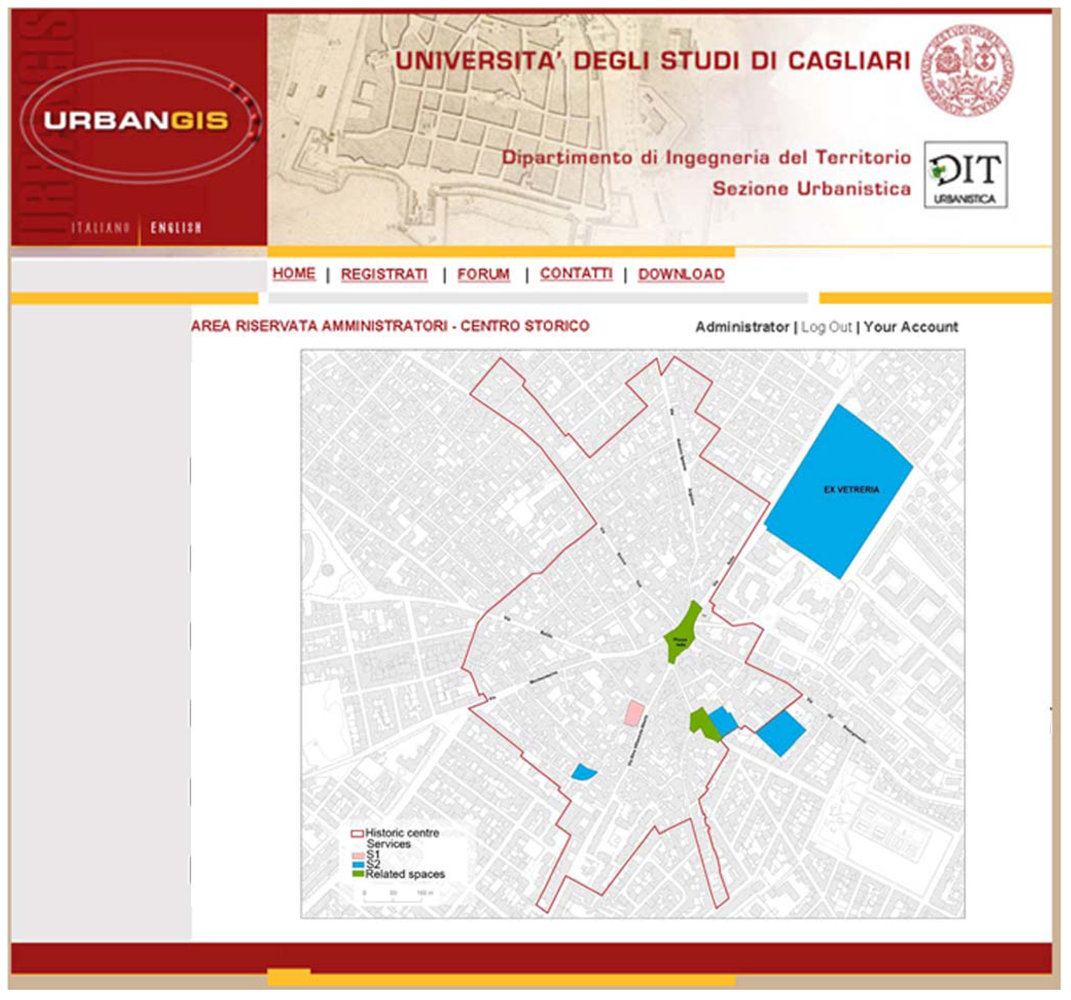
However, the main objective of the DP design team was to consider it as one of the focal targets in drafting the final tables, inserting it into a discourse that would involve the local community directly. In this sense, it was considered essential to use simple and understandable language. Following the outcome of several meetings,
Figure 4 shows part of observations and results produced by the collaboration between engineers and citizens into the project proposals for the neighborhood of Pirri.
Figure 4.
Proposed action—Strategic projects.
Figure 4.
Proposed action—Strategic projects.
5. Conclusions
The participatory approaches, the tools, as well as the more advanced techniques, are certainly more accepted in theory than in practice. In fact they do not ensure the survival of the best urban planning ideas. Moreover, participatory practices, as highlighted by Carp, are difficult to impose because they imply costs in terms of time and attention which are added to changing electoral mandates. They also imply a more complex interpersonal decision-making process which undermines the autonomy and efficiency of planners [
53]. In essence, the rhetoric of the technical and decisive method, may appear more convincing than an appeal to common sense, the ability to listen or design proposals [
54].
Clearly it is necessary to interview citizens, looking for more consistent and effective methodology, which is either interactive, or based on a face to-face approach, or even an efficient combination of different instruments covering both the more traditional and more technological ones [
55,
56]. The new challenges of PPGIS continue to be a development of theories and projects which deal with a wide range of issues cutting across the themes of participation, interaction on the basis of maps and digital communication technologies. Who knows if in the future we will end up with procedures which allow us to govern the territory electronically [
57]. As some authors have theorized, it will certainly require a radical change in bureaucratic thinking [
58].
However, literature on practical applications has shown that, if you look at certain aspects (e.g. put the people first followed by technology; start planning with people and with the tools you have available [
59,
60]; act by reflecting on the core paradigms of the global system [
61,
62], remember that participation is a process which solves the problems and not mere data processing [
63],
etc.), it is possible to achieve specific objectives and a greater adherence of all stakeholders to the decision-making process through the pursuit of effectiveness, efficiency, social justice and sustainability in the long run.
Our intention was essentially aimed at involving the population in the preparation of DP in order to understand if they were “prepared” to cooperate with public administration. It is often assumed that citizens want to intervene in the decision-making processes in order to express their views and put forward new proposals to the experts and that they are just waiting to be given the opportunity, the chance, the cognitive instruments to do so and citizens will therefore immediately be excited and eager to collaborate with the plan’s entourage because “they can’t not be interested”.
In reality, it may well be that “progressive” administrators [
64], confident of the potential of participatory practice, then come up against the apathy of the local population. However, it is our opinion that unless the community is directly concerned in the process of transformation of the territory, it will not always be possible to maintain their interest and overcome these problems.


