Article

Fire Regimes of Remnant Pitch Pine Communities in the Ridge and Valley Region of Central Pennsylvania, USA

by
Joseph M. Marschall
1,*,
Michael C. Stambaugh
1,
Benjamin C. Jones
2,
Richard P. Guyette
1,
Patrick H. Brose
3 and
Daniel C. Dey
3
1
Missouri Tree-Ring Laboratory, School of Natural Resources, University of Missouri, 203 ABNR Building, Columbia, MO 65211, USA
2
Habitat Planning and Development Division, Pennsylvania Game Commission, Harrisburg, PA 17110, USA
3
U.S. Forest Service, Northern Research Station, Newtown Square, PA 19073, USA
*
Author to whom correspondence should be addressed.
Forests 2016, 7(10), 224; https://doi.org/10.3390/f7100224
Submission received: 29 July 2016 / Revised: 23 September 2016 / Accepted: 26 September 2016 / Published: 2 October 2016

Abstract

:
Many fire-adapted ecosystems in the northeastern U.S. are converting to fire-intolerant vegetation communities due to fire suppression in the 20th century. Prescribed fire and other vegetation management activities that increase resilience and resistance to global changes are increasingly being implemented, particularly on public lands. For many fire-dependent communities, there is little quantitative data describing historical fire regime attributes such as frequency, severity, and seasonality, or how these varied through time. Where available, fire-scarred live and remnant trees, including stumps and snags, offer valuable insights into historical fire regimes through tree-ring and fire-scar analyses. In this study, we dated fire scars from 66 trees at two sites in the Ridge and Valley Province of the Appalachian Mountains in central Pennsylvania, and described fire frequency, severity, and seasonality from the mid-17th century to 2013. Fires were historically frequent, of low to moderate severity, occurred mostly during the dormant season, and were influenced by aspect and topography. The current extended fire-free interval is unprecedented in the previous 250–300 years at both sites.

1. Introduction

Natural community restoration is of increasing interest to land managers and scientists throughout the U.S. [1]. Many of these communities are fire dependent and have greatly declined in area due to decades of fire suppression. Prescribed fire and other vegetation management activities (e.g., commercial and non-commercial forest cuttings, mowing/mulching, chemical treatments) are increasingly being applied to increase resilience and resistance to global changes, particularly on public lands [2]. In forests, these activities influence succession and are often applied with the goal of reducing tree density and promoting early successional species and native seedbanks [3]. An understanding of historical ecology, past environmental changes, and long-term ecosystem dynamics is fundamental to such management, and thus provides a reasoned scientific foundation for developing a restoration context [4,5,6].
Fire disturbances are integral to creating and sustaining diverse ecosystems throughout the eastern U.S. [7,8,9,10]. Many fire-dependent ecosystems in the eastern U.S. have remained unburned for nearly a century due to fire-suppression policies initiated in the early 20th century [11,12,13,14]. As a result of this current era of fire suppression, fire-dependent plant species and communities are declining in abundance and failing to regenerate throughout the eastern U.S. [15,16,17,18,19], leading to regional losses in biodiversity and habitat quality [10,20,21,22,23,24].
Restoring fire regimes can create unique communities and species assemblages across taxonomic levels of plants and animals in eastern U.S. ecosystems [3,7,10,25,26]. Restoration of historically fire-dependent ecosystems is essential for creating or improving wildlife habitats [27,28,29]. There is little quantitative data describing historic fire regime attributes such as frequency, severity, and seasonality, or how these varied through time and across regions and habitats in these ecosystems [30]. Defining such fire regime characteristics necessitates regionally-based information because fire regimes vary due to factors such as topography, climate, vegetation, and ignition sources [31,32].
Recurring fires were historically important for maintaining fire-dependent communities in the eastern U.S., particularly pine and/or oak forests, woodlands, and scrublands [33,34,35,36]. For the region of interest in this study, the Ridge and Valley Province of central Pennsylvania, the widespread exclusion of fire is deemed as a “major threat” to key habitats for species of greatest conservation need in Pennsylvania’s State Wildlife Action Plan [28]. Under its mandate to provide hunting opportunity and conserve wildlife habitat, the Pennsylvania Game Commission (PGC) is embarking on landscape-scale habitat restoration using prescribed fire as a primary tool [37]. Success of these ecological restoration efforts will be enhanced by a greater understanding of the fire regime conditions that maintained functionality of these ecosystems [38].
In this study, we used dated fire scars on cross-sections of dead and live pitch pine (Pinus rigida) trees to describe the historical and current fire regimes of two sites in the Ridge and Valley Province of central Pennsylvania. Dating fire scars on old or preserved trees is recognized as one of the best methods to reconstruct fire regimes. Despite little use in previous studies, pitch pine is ideal for reconstructing historical fire events because of its longevity, ability to survive and record multiple fires, and potential for preservation after death due to high resin content. Multiple characteristics of pitch pine indicate that it is a fire-adapted tree species, including basal and epicormic sprouting ability, thick bark, and cone serotiny [39,40,41,42].
The objectives of this research were to: (1) quantify historical fire regime characteristics; (2) identify associations among fire frequency/occurrences and major fire environment factors (human populations, climate conditions, drought, topography); and (3) discuss the implications of these findings to restoration efforts and fire and vegetation management.

2. Materials and Methods

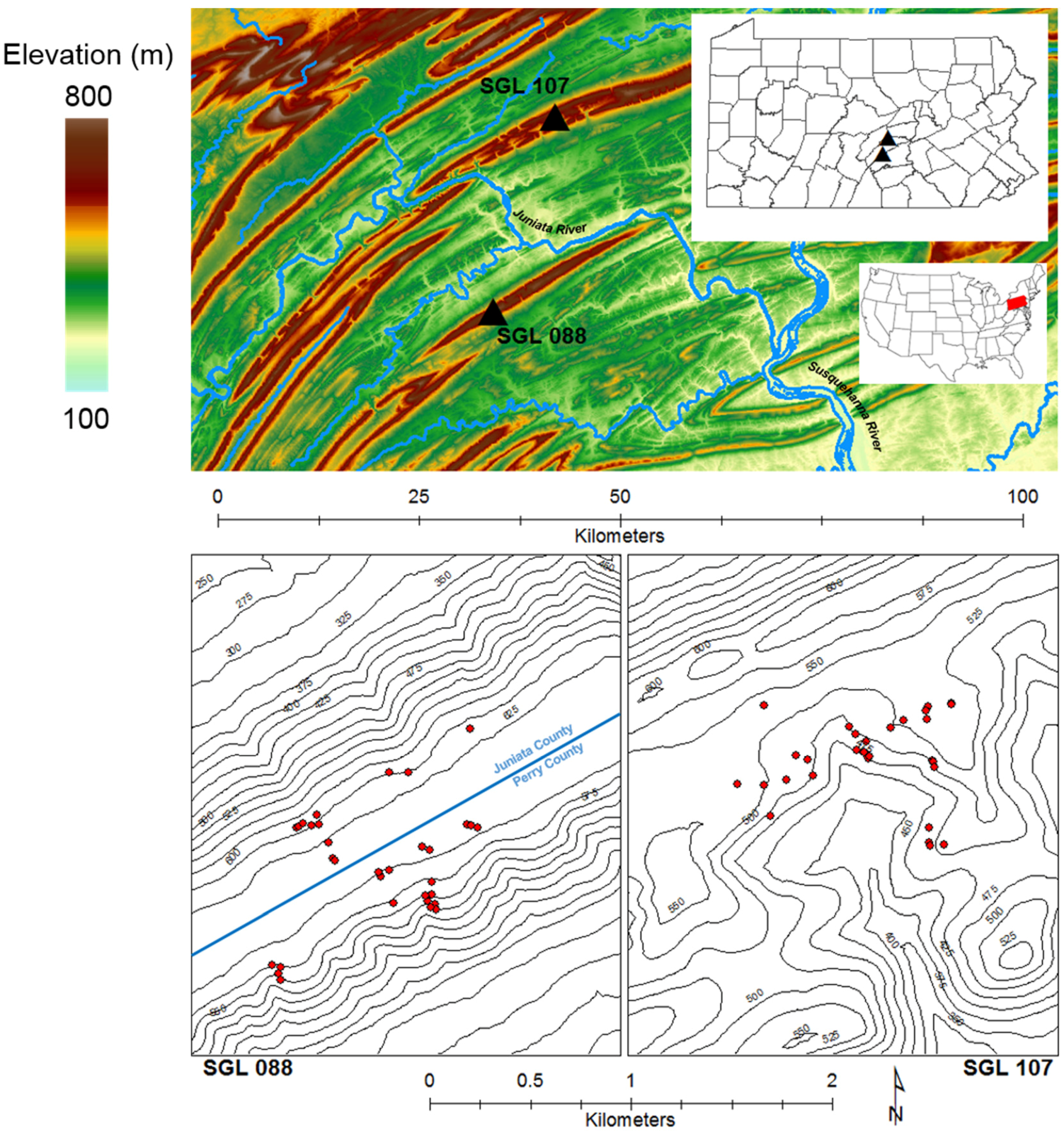
2.1. Study Site Descriptions

From field reconnaissance conducted during 2010 and 2011, two study sites were identified based on the presence of fire-scarred pitch pine remnants (stumps and dead trees). These sites are located in the Appalachian Mountain Section of the Ridge and Valley Province [43] of Juniata and Perry Counties, Pennsylvania, USA (Figure 1). In this region, annual mean precipitation is between 107 and 112 cm, and mean annual temperature is 12 °C (source: NOAA). Mean annual snowfall ranges from 79 to 102 cm and occurs from mid-October to late April (source: NOAA). This region is characterized by long paralleling ridges and adjacent valleys (trending west-southwest, approximately 250°) and is currently comprised of a mixture of agricultural lands, forested ridges, and rural communities.
Study sites are separated 25 km north to south by the Juniata River valley on lands owned and managed by PGC (State Game Lands 088 and 107, hereafter SGL 088 and SGL 107). The SGL 088 study site (40°27′17.8″ N, 77°25′26.4″ W) is located on the south side of the Juniata River on ridgetop, opposing shoulder, and mid-slope positions of Tuscarora Mountain, straddling the boundary of Perry and Juniata Counties (Figure 1). The topography is characterized as a relatively flat ridgetop, approximately 320 m wide, running SW/NE and providing slopes with NW and SE aspects. The SGL 107 study site (40°40′21.8″ N, 77°19′52.0″ W) is located on the opposite (northern) side of the Juniata River in Juniata County. The site is positioned on a sub-apex bench on the south-facing slope of Shade Mountain, at the top of a minor drainage (Laurel Run). According to PGC records, the lands on which the study sites occur were acquired by PGC in the early 1930s, and both sites are comprised of closed-canopy forests that initiated circa 1900.
Both mountains are capped by resistant Tuscarora Formation quartzite and rise approximately 500 m above the Juniata River valley [44]. Both sites were classified by PGC’s ecological classification system as Dry Oak—Heath Forests, noted to occur on xeric, acidic soils with the forest overstories typically dominated by chestnut (Quercus montana), black (Q. velutina), scarlet (Q. coccinea), and white (Q. alba) oak, along with other species, including black gum (Nyssa sylvatica) and sweet birch (Betula lenta) [45]. Based on site inventory data, the forest overstories of both sites are currently fully stocked and dominated by chestnut oak and black gum; 67% and 68% combined for SGL 088 and SGL 107, respectively. At SGL 088, the remaining composition is sweet birch (12%), red maple (Acer rubrum, 10%), black oak (7%), and 2% or less of eastern hemlock (Tsuga canadensis), serviceberry (Amelanchier arborea), and sassafras (Sassafras albidum). The remaining composition at SGL 107 is occupied by northern red oak (Quercus rubra, 11%), red maple (10%), white oak (10%), and eastern hemlock (2%). Very minor components of pitch and white pine (Pinus strobus), and American chestnut (Castanea dentata) were observed at both sites. In PGC’s classified Dry Oak—Heath Forests, shrub layers are commonly dominated by ericaceous species, including mountain laurel (Kalmia latifolia) and other genera (e.g., Gaylussacia, Vaccinium) at such densities that the resulting herbaceous layer is sparse and the primary ground cover is leaf litter [45].
The paucity of living pitch pine, and abundance of pitch pine remnants and fire-intolerant tree species (i.e., red maple, birch) at these sites are indicative of recent prolonged fire intervals [16,46]. The apparent ‘mesophication’, sensu Nowacki and Abrams (2008) [10], of these ecosystems is of concern to PGC habitat managers because wildlife habitat quality, hunting opportunity, and ecosystem resiliency are decreased. This concern applies to management areas across the Ridge and Valley Province, not just the two sites studied here.

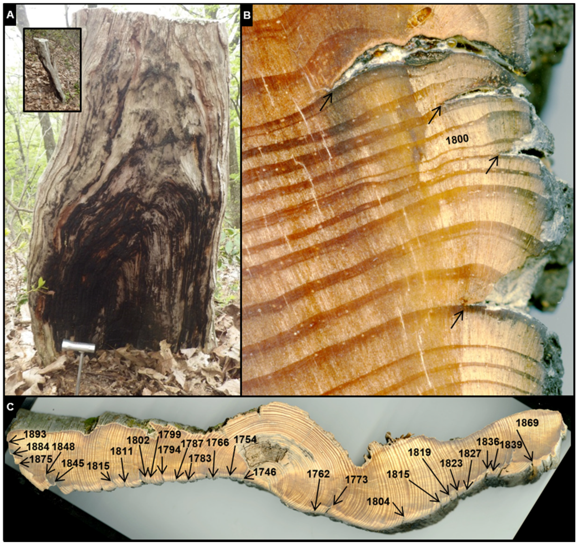
2.2. Data Collection

Fire-Scar Data

Study sites were surveyed for living and dead (stumps and snags) fire-scarred pitch pine trees in May 2014. Full and partial basal cross-sections (~20 cm thick) were removed from trees using a chainsaw (Figure 2). Cross-sections were collected from 39 trees at SGL 088; seven of which were excluded from the study due to rot and/or too few annual growth rings for dendrochronological dating. Cross-sections were collected from 40 trees at SGL 107, six were excluded due to rot and/or too few annual growth rings. The sampling area encompassed approximately 0.70 km2 for SGL 088, and 0.61 km2 for SGL 107, measured using the Minimum Bounding Geometry Tool (Convex Hull type) in ArcGIS (v. 10.3). On some trees, multiple cross-sections were collected at different heights above ground to capture the most complete fire record possible. Cross-sections were assigned a sample number, aspect, orientation, and geographic location. Cross-sections were transported to the Missouri Tree-Ring Laboratory at the University of Missouri (Columbia, MO, USA) for surface preparation and analysis.

2.3. Fire-Scar Data Analysis

Top and bottom surfaces of cross-sections were prepared using an electric orbital sander with progressively finer sandpaper (80 to 1200 grit) to reveal cellular detail of annual rings and fire scars. A radius (pith-to-bark) of each cross-section with the least amount of ring-width variability due to callus was chosen for tree-ring width measurement. All rings were measured to 0.01 mm precision using a binocular microscope and a Velmex measuring stage (Velmex, Bloomfield, New York, NY, USA). Tree ring-width series from each sample were visually cross-dated using ring-width plots [47]. Cross-dating was statistically verified with the COFECHA computer program [48,49]. Fire scars were dated to the year of cambial response to injury and, if possible, to a within-ring location following Kaye and Swetnam (1999) [50]. The number of years with a growing-season fire scar were tallied. Fire scars were identified by the presence of callus tissue, traumatic resin canals, liquefaction of resin, and cambial injury [51].
We used FHX2 software [52] to construct the fire event chronology, analyze fire-scar years, and graph individual tree and composite fire intervals (years between fire events). Fire-scar statistical analysis was restricted to only include time periods which included at least 3 trees in the tree-ring record, resulting in a 349-year record (1663–2013) for SGL 088, and 369-year record (1644–2013) for SGL 107. Mean fire intervals (MFIs), standard deviations, and lower/upper exceedance intervals were computed. The exceedance intervals indicate if a fire interval is significantly longer or shorter than the mean (per time period). Kolmogorov-Smirnov (K-S) Goodness-of-fit tests conducted on the frequency distribution of fire intervals were used to determine whether a Weibull distribution modeled the interval data better than a normal distribution [53]. Weibull median fire intervals were recorded when appropriate. The percentage of trees scarred in fire years and the average per time period (mean percentage of trees scarred) were calculated. K-S tests were conducted using SAS statistical software version 9.4 [54] to determine if MFIs or mean percentage of trees scarred were statistically different (α < 0.05) between sites and time periods (intra-site).
The locations of fire-scarred remnant pitch pine wood at SGL 088 on Tuscarora Mountain were well-suited to be divided to test for fire regime differences by aspect. The center of the broad plateau top of Tuscarora Mountain (~320 m wide) marks the boundary between Juniata (to the north) and Perry Counties, and served as the line to divide the fire-scar data for comparison, resulting in 12 samples from the north-facing slope and 20 from the south-facing slope. There is interest among research and land management communities regarding how fire regimes differed by aspect and landscape position [55].
The time period recorded by samples was divided into three sub-periods based on cultural and land-use changes: pre-1754 (pre-European settlement), 1755–1914 (European settlement), and 1915–2013 (fire suppression). We identified 1754 as a division year for the pre-European settlement time period based on the Albany Purchase whereby the region was sold to the United States by the Iroquois [56]. The Albany Purchase led to increased colonial settlement and conflict with Native Americans in the study region [56,57]. The pre-European settlement period included in fire interval analyses (SGL088: 1663–1754; SGL107: 1644–1754) does not reflect a Native American fire regime entirely free of European influence. Colonial settlement along the eastern seaboard of the United States and contact through fur trade activities had already led to displaced Native American populations and increased intra-native conflicts [58,59]. In addition, Native American populations were already significantly reduced across the eastern U.S. due to European diseases [59,60,61,62]. We determined 1915 to be the first year of the fire suppression era based on the associated establishment of the Bureau of Forest Protection under the Pennsylvania Department of Forestry [12] which instigated a new period of forest protection policies that included fire suppression [11].

2.4. Fire and Climate Analysis
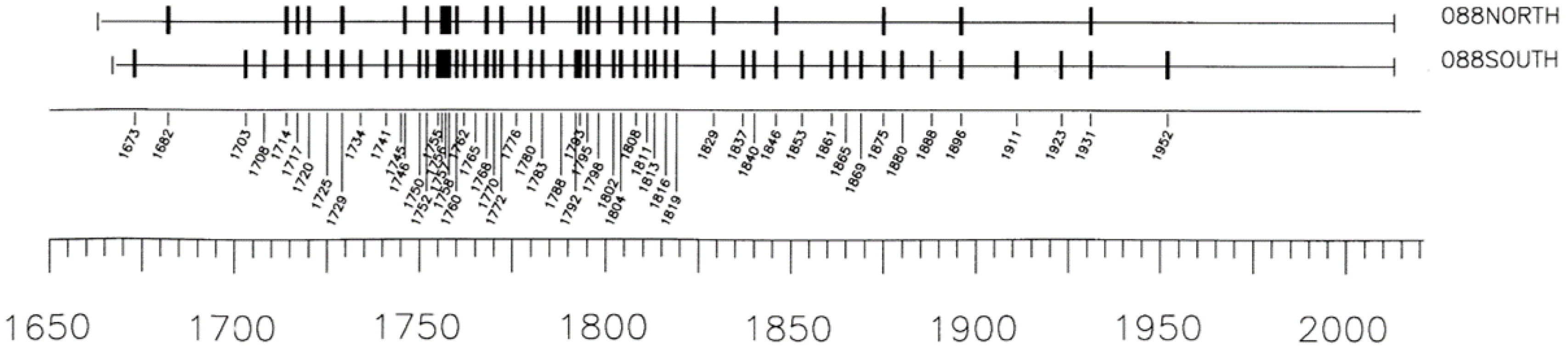
Associations between historical fire events and drought conditions were tested using superposed epoch and correlation analysis. Superposed epoch analysis (SEA) was conducted separately for fire events at each study site then again for shared fire event years between the sites and between aspects at SGL 088. SEA was conducted for the full period of record and 50-year sub-periods from 1650 to present (e.g., 1650 to 1700, 1700 to 1750). SEA was performed within the Fire History Analysis and Exploration System (FHAES v. 2.0.1) [63]. Drought data consisted of reconstructed summer season Palmer Drought Severity Indices (PDSI) [64]. PDSI data were bootstrapped for 1,000 simulated events to derive confidence limits. Fire event years were paired with PDSI to determine if conditions were significantly wet or dry from six years preceding to four years succeeding fire events. Conditions prior to, during, and following fire events were considered significantly wet or dry when average PDSI values exceeded confidence limits. Separately, Pearson correlations were used to test for relationships between PDSI and the percentages of trees scarred during fire years. Reconstructed PDSI data were obtained for the two nearest gridpoints to the study sites (gridpoints 254, 255) and SEA analyses were conducted separately for each gridpoint.

3. Results

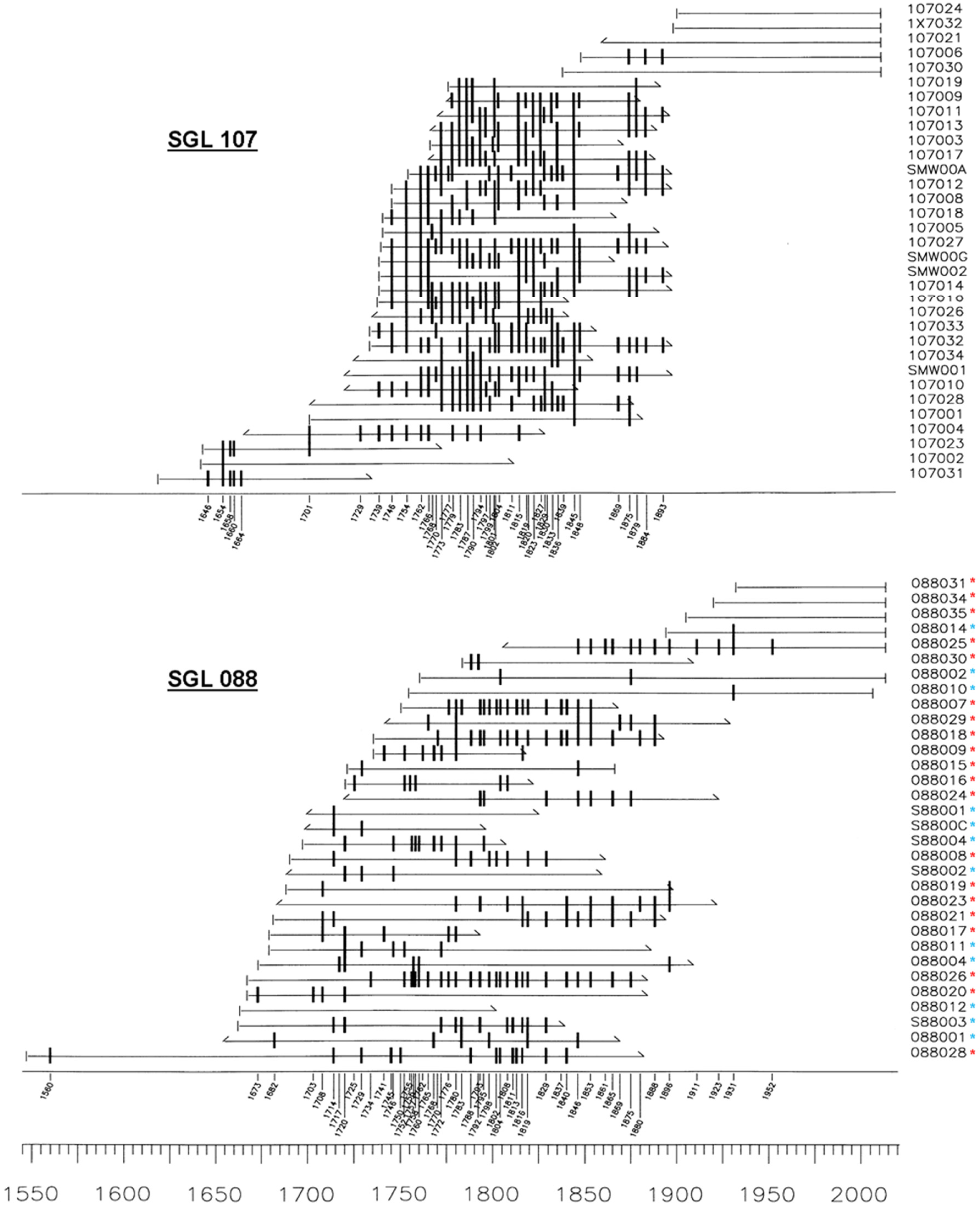
3.1. Tree-Ring and Fire-Scar Data

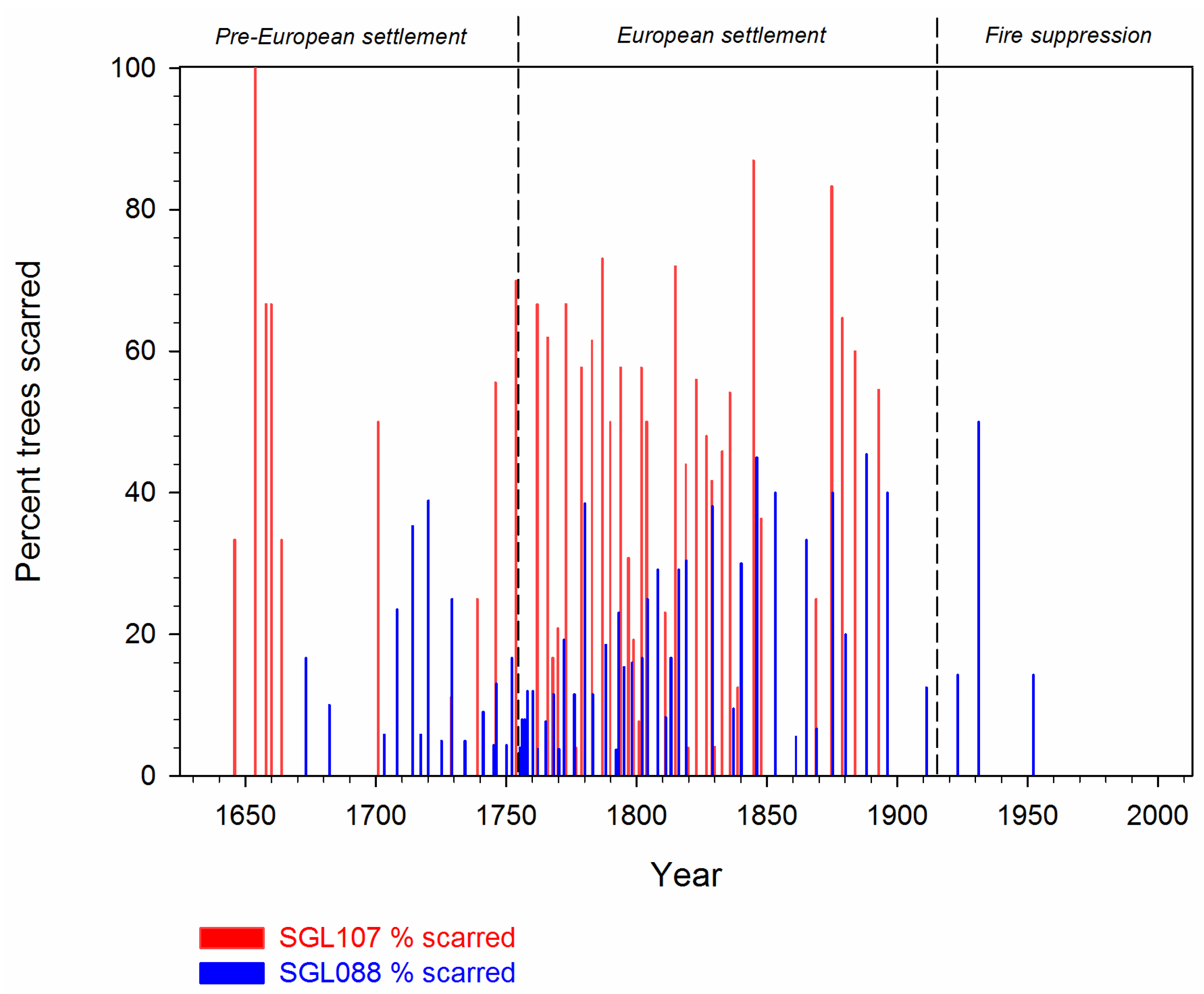
3.1.1. All-Time Period

The time periods spanned by tree-rings were 1548 to 2013 CE for SGL 088, and 1620 to 2013 CE for SGL 107 (Table 1, Figure 3). Fire-scar statistical analyses were only conducted for the time periods during which at least 3 trees were present in the tree-ring record, 1663–2013 at SGL 088 and 1644–2013 at SGL 107. During this period (all-time period), samples from SGL 088 (n = 32) revealed 201 fire scars from 56 different fire years. In comparison, samples from SGL 107 (n = 33) recorded more fire scars (n = 387) from fewer fire years (n = 44). Considering the two sites together, 87 unique fire years were identified; 13 (15%) of which were common to both sites. At SGL 088, composite fire intervals ranged from 1 to 21 years, with an MFI of 5.1 years. At SGL 107, composite fire intervals had a wider range (1–37 years), with a similar MFI of 5.7 years. MFIs did not differ significantly between sites, though the mean percentage of trees scarred did (p < 0.0001). At SGL 088, the mean percentage of trees scarred was less than half that of SGL 107 (18.7% vs. 46.4%, respectively; Table 1, Figure 4).
Season of injury was identifiable on over half of the fire scars at both sites (Table 2). Approximately 40% of the fire scars at both sites were not identified to season of injury due to missing wood (caused by rot) or obscured wood anatomy at the union of injured and uninjured cells. At both sites, a large proportion of fire scars (98.3% and 95.1% for SGL 088 and SGL 107, respectively) with season of injury identified were in the dormant season tree-ring position (Table 2).

3.1.2. Pre-European Settlement Period (Pre-1755)

During the pre-European settlement era, samples from SGL 088 recorded 40 fire scars from 15 different fire years, while SGL 107 had a similar number of fire scars (n = 39), but from fewer (n = 10) fire years. For SGL 088, composite fire intervals ranged from 1 to 21 years, with an MFI of 5.6 years. Composite fire intervals at SGL 107 ranged from 2 to 37 years, with an MFI of 12.0 years. Fire intervals were not significantly different between the sites. The mean percentage of trees scarred at SGL 088 was significantly less than that at SGL 107 (p = 0.006, Table 1). During this time period, the majority (61.5%) of fire scars at SGL 107 had unidentified seasonality, more than any other time period record at either site. Most fire scars with identifiable seasonality were in the dormant tree-ring position, though slightly more scars occurred in the growing season relative to the other periods considered (Table 2).

3.1.3. European Settlement Period (1755 to 1914)

During this period, fire occurrence was higher and more similar between sites than during any other time period (Table 1). MFIs were statistically similar at both sites (4.2 and 4.0 years at SGL 088 and SGL 107, respectively), though SGL 107 continued to have a significantly higher mean percentage of trees scarred (p < 0.0001). At both sites, most of the fire scars and years assigned seasonality were in the dormant season (Table 2).

3.1.4. Fire-Suppression Period (1915 to 2013)

There were 3 fire years at SGL 088 during this time period, and none at SGL 107. MFIs were not calculated due to an insufficient number of observations; however, if the open interval at the end of each fire chronology is accounted for by considering the bark year to be a fire year, MFIs are greater than 30 and 90 years for SGL 088 and SGL 107, respectively. At SGL 088, 3 of the 5 fire scars were in the dormant position and two were not able to be assigned season of injury.

3.1.5. Intra-Site Fire Regime Characteristics across Time Periods

At SGL 088, no significant differences in mean percentage of trees scarred or MFI were detected between the pre-European and European settlement time periods (Table 1). At SGL 107, no significant difference in the mean percentage of trees scarred between time periods was detected; however, MFI was significantly longer (p = 0.02) during the pre-European period than the European settlement period.

3.1.6. Aspect Influence at SGL 088

Twenty trees were sampled on the south-facing slope compared to 12 on the north-facing slope at SGL 088. Years with fire were nearly twice as frequent on south-facing versus north-facing slopes (Table 3, Figure 5), though MFIs were not statistically different. Between aspects, the mean percentage of trees scarred was similar during the all-time and pre-European settlement periods, though more trees on the south-facing slope were scarred on average (p = 0.039) during the European settlement period (Table 3). North-facing and south-facing slopes shared 44.6% (n = 25 years) of all fire years.

3.2. Fire and Drought

From 1550 to 2003, PDSI values ranged from −5.0 (extreme drought) to 3.8 (very wet) with a mean of −0.28 (near normal). Over the fire-scar record, the climatic conditions before, during, and following fire years were not significantly wet or dry at either study site. When considered in 50-year sub-periods, SGL 088 site showed drought conditions were significantly dry one year prior and in the year of fire for the 1850 to 1900 and 1900 to 1950 sub-periods, respectively. This result was consistent regardless of considering drought data from either drought data gridpoint. For SGL 107, drought-fire associations through SEA were inconsistent when considering sub-periods and drought data gridpoint. Fire years shared between SGL 088 and SGL 107 showed significantly drier conditions 5 years prior and 2 years following fires, whereas 2 years prior to fire had significantly wetter conditions. No significant drought-fire associations were detected for shared fire years between aspects at SGL 088. PDSI was weakly related to percentages of trees scarred at SGL088 (r = 0.28, p = 0.04). No other correlations between drought and percentages of trees scarred were found.

4. Discussion

4.1. Characterizing Historical Fire Regimes

4.1.1. Fire Frequency

Over the last four centuries, fire regimes of the sites studied here can be characterized as frequent, yet variable through time. In general, MFIs were short (5.1 and 5.7 years; Table 1), despite fire-suppression effects during the 20th century. Fire intervals were positively skewed prior to the fire-suppression era with the majority of intervals being 1 to 5 years in length (Figure 6). At both sites, multiple incidences of annual burning were documented. Similarly, at both sites, long fire-free intervals were documented (Table 1) that likely had important effects on vegetation communities and successional pathways [6].
The fire frequencies reported here are comparable to those of two previous studies conducted in yellow pine forests of the Ridge and Valley Province [65,66], located approximately 750 and 420 km to the south, respectively. Another study, also to the south, but closer (approximately 180 km) on the Appalachian Plateau, also reported similar fire frequencies from white oaks [67]. Conversely, the MFIs reported here are over 3 times shorter than those reported for red pine (Pinus resinosa) stands [35,68] approximately 100 km to the north in the highly dissected Deep Valleys physiographic region of the Appalachian Plateau. We expect that differences in regional topography, climate, and human influences were major contributing factors for these regional fire frequency differences. In Missouri, USA, historical fire frequency was found to be driven by humans, yet mitigated by topographic roughness [31]. At broader regional extents, historical fire frequency is strongly correlated with regional climate variability, particularly across Pennsylvania [32].
MFIs did not differ statistically between sites or time periods, except for the pre-European and European settlement time periods at SGL 107 (Table 1). During the pre-European time period, SGL 107 had two significantly long fire intervals (1664–1701, 1701–1729; Figure 3); interestingly, both were preceded by a brief episode of frequent fires (1646–1664; Figure 3). Though there are relatively few trees recording during this time of infrequent fires (1664–1729), the 4 trees recording were relatively small and likely sufficiently describe fire activity at the site. This change from high to low fire frequency does not appear to be associated with exceptionally wet or dry conditions and may indicate influence by humans. During the early and mid-17th century, large-scale depopulation and emigration events of Native Americans occurred across the eastern seaboard of northeastern North America [59,62,69,70]. If humans were a primary ignition source, then decreased populations would be expected to result in decreased fire frequency—a relationship observed in other locations [68,71,72,73]. Effects of decreased populations may also account for the conspicuous fire-free period at SGL 107 from 1848 to 1869. During this time, Brose et al. [68] also identified a longer than expected fire interval and suggested that it related to the American Civil War (1861–1865), specifically a decrease in human ignitions caused by men leaving the region to enlist in the Union Army.
Many fire history studies in the eastern U.S. have identified human population, settlement patterns, and commerce activities to be closely associated with changes in fire frequency [16,35,71,72,73,74,75,76]. Compared to human ignitions, lightning ignitions are rare in the northeastern U.S. Most lightning events are accompanied by rain and high levels of humidity, further implicating humans as an important fire ignition source for maintaining frequent fire regimes [77]. Fire records from 1979 to 2013 show 1.3% of fires reported in Pennsylvania were ignited by lightning, and resulted in 1.5% of the total area burned [78]. Based on the lack of association between drought and fire occurrence, as well as the paucity of lightning-caused ignitions, we suggest that the fire frequency findings in this study are attributable to human factors such as population, occupancy, and migration patterns.

4.1.2. Fire Severity and Extent

Historical fire severity is difficult to document using dendrochronological methods. In non-stand replacement fire regimes, fire severity may be approximated by the percentages of trees scarred [79]. Based on the long-term presence of trees (Figure 3), evidence for stand-replacing fires did not exist; therefore, we expect that historical fires were primarily low- to moderate-severity surface events. A fire scar only indicates that a tree was injured and survived; other metrics of past fire severity (e.g., substrate changes, vegetation mortality, scorch height) are less easily measured, especially over long time periods and following multiple fires. In this study, SGL 107 exhibited significantly higher levels of percentages of trees scarred than SGL 088 (Table 1, Figure 4). Causes for this difference are unknown, but we expect it is due to topographic and landscape position differences as opposed to differences in ignitions (e.g., timing, locations). SGL 088 spans a convex ridge top while SGL 107 is contained within a concave slope at the upper-most section of a single minor drainage (Figure 1). Fires burning upslope at SGL 088 would have to cross north-south aspects, while at SGL 107, a fire burning upslope would have a high probability of burning the entire extent of the study area due to continuous slopes, pre-heating effects, and no aspect changes or other major fire barriers or fire intensity moderating landscape features.

4.1.3. Fire Seasonality

As indicated by the fire scars for which season of injury could be determined, the majority of historical fires occurred in the dormant season. It is important to note that historical fire seasonality is determined by the growth period of the recorder trees and that fires occurring during this dormancy period cannot be further separated into fall or spring occurrences. Tree (i.e., cambial growth) dormancy occurs from approximately September to May in central Pennsylvania, although timing varies from year to year due to climate conditions. More precise determination of historical fire timing within the dormant season could be extrapolated based on Ryan et al. (2013) [3], who speculated that historical, like modern era fire regimes, were separated into spring and fall seasons. Modern era (1940–2015) monthly wildfire records indicate most wildfires occur during March, April, and May, with a much smaller portion of occurrences in October and November [78]. In recent decades, prescribed fire activity has been greatest in the late winter/early spring months. Taken together, these sources suggest that dormant season fires may have predominantly occurred in the late winter/early spring time periods, but may also have included late fall or early winter.
Growing season fires historically had a minor presence at our study sites, and the majority of these events occurred during the pre-European settlement period (Table 2). That fires occurred overwhelmingly during the dormant season is consistent with previous fire history studies in the eastern U.S. [35,65,66,67,68]. Distinction of historical fire seasonality has important implications for both fire and vegetation interpretations. For example, Sparks et al. [80] found growing and dormant season fires had differing effects on herbaceous community composition and structure in the shortleaf pine (P. echinata) woodlands in the Ouachita Mountains, Arkansas. Albeit infrequent, our findings indicate that growing season fire did occur historically in these pitch pine communities, and may be required to achieve certain desired fire effects.

4.2. Management Implications

The historically high frequency of fire reported at both sites, along with the high density of remnant pitch pine trees (stumps and snags) relative to the very few living pitch pine present, is evidence that these sites have undergone significant ecological changes (e.g., vegetation type conversion, open to closed canopy structure, herbaceous/grass to tree leaf litter fuel type transition, altered carbon and nutrient cycles) coincident with the onset of the fire-suppression era. The resulting extended fire-free period is outside of the historic range of variability reported in this study, and is reflected by the minor presence of pitch pine in the current vegetation community. Overall, the findings of this study support the current understanding of pitch pine ecology, specifically its association with frequent fire occurrence. Based on this history, fire is ecologically appropriate to restore, manage, and perpetuate pitch pine communities into the future.
The differences in historical fire severity between SGL 088 and SGL 107 suggest that aspect and landscape position should be considered when planning management activities. For some historical fires, contrasting fire effects due to aspect existed, and therefore can be expected within a single prescribed fire compartment. Exceptions likely exist in very dry conditions when fuel moisture is not differentiated by aspect. At SGL 088 there were nearly double the number of fire years for all time periods on south- versus north-slopes, likely indicating a different historical vegetation and fuels matrix and/or fuel moisture, i.e., oak and other hardwoods refugia on north-facing slopes, pine and grasses dominating on those facing south [81,82,83]. These findings, as well as the fact that pine remnants were found in landscape positions below the ridgetop (Figure 2, both sites), demonstrate that fires and fire-adapted species were not relegated only to supposed pyrogenic microsites (e.g., ridgetops), as suggested by Matlack (2013) [55]. Additional studies describing variability in fire regimes across a range of spatial extents would further inform management of larger landscapes.

5. Conclusions

This paper presents evidence that fire regimes of pitch pine communities in the Ridge and Valley Province of central Pennsylvania were historically frequent, of low to moderate severity, and dominated by dormant season fire events. This fire regime information can be used to guide modern fire management and restoration of fire-dependent ecosystems. Additional studies characterizing fire regimes in Pennsylvania would help to refine description of fire regimes and aid in understanding their variability and driving influences.

Acknowledgments

Identification of study sites was supported by the U.S. Forest Service, Northern Research Station. This research was funded by the Pennsylvania Game Commission. We thank David Matthew Bourscheidt for data collection assistance in the field, Erin Abadir for help identifying cultural and land-use periods, and Chris Bobryk for cartography assistance. We are grateful for contributions from two anonymous reviewers, which improved the manuscript.

Author Contributions

J.M.M. conceived the study, conducted fieldwork, analyzed data, wrote the manuscript; M.C.S. conceived the study, conducted fieldwork, analyzed data, and wrote the manuscript, B.C.J. conducted fieldwork and wrote the manuscript, R.P.G. conceived the study and wrote the manuscript, P.H.B. aided in locating study sites and wrote the manuscript, D.C.D. wrote the manuscript.

Conflicts of Interest

The authors declare no conflict of interest.

References

  1. Cohesive National Wildland Fire Management Strategy. The Final Phase in the Development of the National Cohesive Wildland Fire Management Strategy. 2014. Available online: https://www.forestsandrangelands.gov/strategy/documents/strategy/CSPhaseIIINationalStrategyApr2014.pdf (accessed on 15 May 2016).
  2. Brandt, L.; He, H.; Iverson, L.; Thompson, F.R., III; Butler, P.; Handler, S.; Janowiak, M.; Danielle, S.P.; Swanston, C.; Albrecht, M.; et al. Central Hardwoods Ecosystem Vulnerability Assessment and Synthesis: A Report from the Central Hardwoods Climate Change Response Framework Project; USDA Forest Service General Technical Report NRS-124; Northern Research Station: Newtown Square, PA, USA, 2014. [Google Scholar]
  3. Ryan, K.C.; Knapp, E.E.; Varner, J.M. Prescribed fire in North American forests and woodlands: History, current practice, and challenges. Front. Ecol. Environ. 2013, 11, e15–e24. [Google Scholar] [CrossRef]
  4. Engstrom, R.T.; Gilbert, S.; Hunter, M.L., Jr.; Merriwether, D.; Nowacki, G.J.; Spencer, P. Practical applications of disturbance ecology to natural resource management. In Ecological Stewardship: A Common Reference for Ecosystem Management; Johnson, N.C., Malik, A.J., Sexton, W.T., Szabo, R.C., Eds.; Elsevier: Oxford, UK, 1999; Volume 2. [Google Scholar]
  5. Swetnam, T.W.; Allen, C.D.; Betancourt, J.L. Applied historical ecology: Using the past to manage for the future. Ecol. Appl. 1999, 9, 1189–1206. [Google Scholar] [CrossRef]
  6. Stambaugh, M.C.; Marschall, J.M.; Guyette, R.P. Linking fire history to successional changes of xeric oak woodlands. For. Ecol. Manag. 2014, 320, 83–95. [Google Scholar] [CrossRef]
  7. Abrams, M.D. Fire and the development of oak forests. BioScience 1992, 42, 346–353. [Google Scholar] [CrossRef]
  8. Lorimer, C.G. Historical and ecological roles of disturbance in eastern North American forests: 9000 Years of change. Wildl. Soc. Bull. 2001, 29, 425–439. [Google Scholar]
  9. Ruffner, C.M. Understanding the evidence for historical fire across eastern forests. In Fire in Eastern Oak Forests: Delivering Science to Land Managers, Proceedings of a Conference, Columbus, OH, USA, 15–17 November 2005; Dickinson, M.B., Ed.; Gen. Tech. Rep. NRS-P-1. Northern Research Station: Newtown Square, PA, USA, 2006; pp. 40–48. [Google Scholar]
  10. Nowacki, G.J.; Abrams, M.D. The demise of fire and ‘‘Mesophication’’ of forests in the eastern United States. BioScience 2008, 58, 123–138. [Google Scholar] [CrossRef]
  11. Taber, T.T. Logging Railroad Era of Lumbering in Pennsylvania. In Sunset along the Susquehanna; Lycoming Printing Company: Williamsport, PA, USA, 1972; Volume 4. [Google Scholar]
  12. Decoster, L.A. The Legacy of Penn’s Woods: A History of the Pennsylvania Bureau of Forestry; Pennsylvania Historical and Museum Commission: Harrisburg, PA, USA, 1995. [Google Scholar]
  13. Johnson, A.S.; Hale, P.E. The historical foundations of prescribed burning for wildlife: A Southeastern perspective. In The Role of Fire in Nongame Wildlife Management and Community Restoration; Ford, W.M., Russell, K.R., Moorman, C.E., Eds.; U.S.D.A. Forest Service Northeastern Research Station: Newtown Square, PA, USA, 2002; pp. 11–23. [Google Scholar]
  14. Donovan, G.H.; Brown, T.C. Be careful what you wish for: The legacy of Smokey Bear. Front. Ecol. Environ. 2007, 5, 73–79. [Google Scholar] [CrossRef]
  15. Lorimer, C.G. Development oak forests. For. Sci. 1984, 30, 3–22. [Google Scholar]
  16. Nowacki, G.J.; Abrams, M.D. Community, edaphic, and historical analysis of mixed oak forests of the Ridge and Valley Province in central Pennsylvania. Can. J. For. Res. 1992, 22, 790–800. [Google Scholar] [CrossRef]
  17. Harrod, J.C.; Harmon, M.E.; White, P.S. Post-fire succession and 20th century reduction in fire frequency on xeric southern Appalachian sites. J. Veg. Sci. 2000, 11, 465–472. [Google Scholar] [CrossRef]
  18. McEwan, R.W.; Muller, R.N. Spatial and temporal dynamics in canopy dominance of an old-growth central Appalachian forest. Can. J. For. Res. 2006, 36, 1536–1550. [Google Scholar] [CrossRef]
  19. Fei, S.L.; Kong, N.N.; Steiner, K.C.; Moser, W.K.; Steiner, E.B. Change in oak abundance in the eastern United States from 1980 to 2008. For. Ecol. Manag. 2011, 262, 1370–1377. [Google Scholar] [CrossRef]
  20. Rodewald, A.D.; Abrams, M.D. Floristics and avian community structure: Implications for regional changes in eastern forest composition. For. Sci. 2002, 48, 267–272. [Google Scholar]
  21. McShea, W.J.; Healy, W.M.; Devers, P.; Fearer, T.; Koch, F.H.; Stauffer, D.; Waldon, J. Forestry matters: Decline of oaks will impact wildlife in hardwood forests. J. Wildl. Manag. 2007, 71, 1717–1728. [Google Scholar] [CrossRef]
  22. Hutchinson, T.F.; Long, R.P.; Ford, R.D.; Sutherland, E.K. Fire history and the establishment of oaks and maples in second-growth forests. Can. J. For. Res. 2008, 38, 1184–1198. [Google Scholar] [CrossRef]
  23. Ratajczak, Z.; Nippert, J.B.; Collins, S.L. Woody encroachment decreases diversity across North American grasslands and savannas. Ecology 2012, 93, 697–703. [Google Scholar] [CrossRef] [PubMed]
  24. McCord, J.M.; Harper, C.A.; Greenberg, C.H. Brood cover and food resources for wild turkeys following silvicultural treatments in mature upland hardwoods. Wildl. Soc. Bull. 2014, 38, 265–272. [Google Scholar] [CrossRef]
  25. Pyne, S.J. Fire in America; University of Washington Press: Princeton, NJ, USA, 1982; p. 655. [Google Scholar]
  26. Pausas, J.G.; Keeley, J.E. A burning story: The role of fire in the history of life. BioScience 2009, 59, 593–601. [Google Scholar] [CrossRef] [Green Version]
  27. McShea, W.J.; Healy, W.M. (Eds.) Oak Forest Ecosystems: Ecology and Management for Wildlife; John Hopkins University Press: Baltimore, MD, USA, 2002; p. 432.
  28. Pennsylvania Fish and Boat Commission. Pennsylvania State Wildlife Action Plan. 2015. Available online: http://fishandboat.com/swap.htm (accessed on 15 May 2016).
  29. Harper, C.A.; Ford, W.M.; Lashley, M.A.; Moorman, C.E.; Stambaugh, M.C. Fire effects on wildlife in the Central Hardwoods and Appalachian Regions. Fire Ecol. 2016, 12, 127–159. [Google Scholar]
  30. Varner, M.J.; Arthur, M.A.; Clark, S.L.; Dey, D.C.; Hart, J.L.; Schweitzer, C.J. Fire in Eastern North American oak ecosystems: Filling the gaps. Fire Ecol. 2016, 12, 1–6. [Google Scholar]
  31. Stambaugh, M.C.; Guyette, R.P. Predicting spatio-temporal variability in fire return intervals using a topographic roughness index. For. Ecol. Manag. 2008, 254, 463–473. [Google Scholar] [CrossRef]
  32. Guyette, R.P.; Stambaugh, M.C.; Dey, D.C.; Muzika, R.M. Predicting fire frequency with chemistry and climate. Ecosystems 2012, 15, 322–335. [Google Scholar] [CrossRef]
  33. Cronon, W. Changes in the Land: Indians, Colonists and the Ecology of New England; Hill and Wang: New York, NY, USA, 1983. [Google Scholar]
  34. Crow, T.R. Reproductive mode and mechanisms for self-replacement of northern red oak (Quercus rubra)—A review. For. Sci. 1988, 34, 19–40. [Google Scholar]
  35. Brose, P.H.; Dey, D.C.; Guyette, R.P.; Marschall, J.M.; Stambaugh, M.C. The influence of drought and humans on the fire regimes of northern Pennsylvania, USA. Can. J. For. Res. 2013, 43, 757–767. [Google Scholar] [CrossRef]
  36. Johnson, L.B.; Kipfmueller, K.F. A fire history derived from Pinus resinosa Ait. for the Islands of Eastern Lac La Croix, Minnesota, USA. Ecol. Appl. 2016, 26, 1030–1046. [Google Scholar] [CrossRef] [PubMed]
  37. Pennsylvania Game Commission. PA Game Commission Strategic Plan 2015–2020. Available online: http://www.pgc.pa.gov/InformationResources/AboutUs/Documents/PGC%20Strategic%20Plan%202015-2020.pdf (accessed on 1 June 2016).
  38. Bowen, B.W. Preserving genes, species, or ecosystems? Healing the fractured foundations of conservation policy. Mol. Ecol. 1999, 8, S5–S10. [Google Scholar] [CrossRef] [PubMed]
  39. Little, S. Prescribed burning as a tool of forest management in the northeastern states. J. For. 1953, 51, 496–500. [Google Scholar]
  40. Vogl, R.J. Fire: A destructive menace or a natural process? In Recovery and Restoration of Damaged Ecosystems, Proceedings of the International Symposium, Blacksburg, VA, USA, 23–25 March 1975; Cairns, J., Jr., Dickson, K.L., Herricks, E.E., Eds.; University Press of Virginia: Charlottesville, VA, USA, 1977; pp. 261–289. [Google Scholar]
  41. Richardson, D.M. Ecology and Biogeography of Pinus; Cambridge University Press: Cambridge, UK, 1998. [Google Scholar]
  42. Keeley, J.E. Ecology and evolution of pine life histories. Ann. For. Sci. 2012, 69, 445–453. [Google Scholar] [CrossRef]
  43. Sevon, W.D. Physiographic Provinces of Pennsylvania, Map 13, 4th ed.; Pennsylvania Geologic Survey: Harrisburg, PA, USA, 2000. [Google Scholar]
  44. Schultz, C.H. (Ed.) The Geology of Pennsylvania; Geological Survey, Department of Conservation of Natural Resources: Harrisburg, PA, USA, 1999.
  45. Stone, B.; Gustafson, D.; Jones, B. Manual of procedure for State Game Land Cover Typing; Commonwealth of Pennsylvania Game Commission, Bureau of Wildlife Habitat Management, Forest Inventory and Analysis Section, Forestry Division: Harrisburg, PA, USA, 2006; revised 2007; p. 79.
  46. Ruffner, C.M.; Abrams, M.D. Relating land-use history and climate to the dendroecology of a 326-year-old Quercus prinus talus slope forest. Can. J. For. Res. 1998, 28, 347–358. [Google Scholar] [CrossRef]
  47. Stokes, M.A.; Smiley, T.L. Introduction to Tree-Ring Dating; University of Chicago Press: Chicago, IL, USA, 1968. [Google Scholar]
  48. Holmes, R.L. Computer-assisted quality control in tree-ring dating and measurement. Tree-Ring Bull. 1983, 43, 69–78. [Google Scholar]
  49. Grissino-Mayer, H.D. Evaluating crossdating accuracy: A manual and tutorial for the computer program COFECHA. Tree-Ring Res. 2001, 57, 205–221. [Google Scholar]
  50. Kaye, M.W.; Swetnam, T.W. An assessment of fire, climate, and Apache history in the Sacramento Mountains, New Mexico. Phys. Geogr. 1999, 20, 305–330. [Google Scholar]
  51. Smith, K.T.; Sutherland, E.K. Fire-scar formation and compartmentalization in oak. Can. J. For. Res. 1999, 29, 166–171. [Google Scholar] [CrossRef]
  52. Grissino-Mayer, H.D. FHX2-Software for analyzing temporal and spatial patterns in fire regimes from tree rings. Tree-Ring Res. 2001, 57, 115–124. [Google Scholar]
  53. Grissino-Mayer, H.D. Modeling fire interval data from the American Southwest with the Weibull distribution. Int. J. Wildl. Fire 1999, 9, 37–50. [Google Scholar] [CrossRef]
  54. SAS Institute Inc. SAS/STAT® 14.1 User’s Guide; SAS Institute Inc.: Cary, NC, USA, 2015. [Google Scholar]
  55. Matlack, G.R. Reassessment of the use of fire as a management tool in deciduous forests of eastern North America. Conserv. Biol. 2013, 27, 916–926. [Google Scholar] [CrossRef] [PubMed]
  56. Muller, E.K. A Concise Historical Atlas of Pennsylvania; Temple University Press: Philadelphia, PA, USA, 1989; p. 44. [Google Scholar]
  57. Jordan, J.W. A History of the Juniata Valley and Its People; Lewis Historical Publishing Co.: New York, NY, USA, 1913; Volume 1, p. 556. [Google Scholar]
  58. Richter, D.K. Facing East from Indian Country: A Native History of Early America; Harvard University Press: Cambridge, MA, USA, 2001. [Google Scholar]
  59. Mann, C.C. 1491: New Revelations of the Americas before Columbus; Knopf Publishing: New York, NY, USA, 2005. [Google Scholar]
  60. Hulbert, A.B. David Zeisberger’s History of the Northern American Indians in 18th Century Ohio, New York, and Pennsylvania; Wennawoods Publishing: Lewisburg, PA, USA, 1910. [Google Scholar]
  61. Wallace, P.A. Thirty Thousand Miles with John Heckewelder; Wennawoods Publishing: Lewisburg, PA, USA, 1958. [Google Scholar]
  62. Williams, M. Americans and Their Forests: A Historical Geography; Cambridge University Press: New York, NY, USA, 1989; p. 599. [Google Scholar]
  63. Fire History Analysis and Exploration System (FHAES). 2015. Available online: http://www.fhaes.org (accessed on 15 June 2016).
  64. Cook, E.R.; Meko, D.M.; Stahle, D.W.; Cleaveland, M.K. North American summer PDSI reconstructions. In IGBP PAGES/World Data Center for Paleoclimatology Data Contribution Series #2004–045; NOAA/NGDC Paleoclimatology Program: Boulder, CO, USA, 2004. [Google Scholar]
  65. Flatley, W.T.; Lafon, C.W.; Grissino-Mayer, H.D.; LaForest, L.B. Fire history, related to climate and land use in three southern Appalachian landscapes in the eastern United States. Ecol. Appl. 2013, 23, 1250–1266. [Google Scholar] [CrossRef] [PubMed]
  66. Aldrich, S.R.; Lafon, C.W.; Grissino-Mayer, H.D.; DeWeese, G.G. Fire history and its relations with land use and climate over three centuries in the central Appalachian Mountains, USA. J. Biogeogr. 2014, 41, 2093–2104. [Google Scholar] [CrossRef]
  67. Shumway, D.L.; Abrams, M.D.; Ruffner, C.M. A 400-year history of fire and oak recruitment in an old-growth oak forest in western Maryland, USA. Can. J. For. Res. 2001, 31, 1437–1443. [Google Scholar] [CrossRef]
  68. Brose, P.H.; Guyette, R.P.; Marschall, J.M.; Stambaugh, M.C. Fire history reflects human history in the Pine Creek Gorge of north-central Pennsylvania. Nat. Areas J. 2015, 35, 214–223. [Google Scholar] [CrossRef]
  69. Williams, G.W. References on the American Indian Use of Fire in Ecosystems; US Department of Agriculture, Forest Service: Washington, DC, USA, 2003.
  70. Nevle, R.J.; Bird, D.K.; Ruddiman, W.F.; Dull, R.A. Neotropical human-landscape interactions, fire, and atmospheric CO2 during European conquest. The Holocene 2011, 21, 853–864. [Google Scholar] [CrossRef]
  71. Guyette, R.P.; Muzika, R.M.; Dey, D.C. Dynamics of an anthropogenic fire regime. Ecosystems 2002, 5, 472–486. [Google Scholar]
  72. Guyette, R.P; Spetich, M.A.; Stambaugh, M.C. Historic fire regime dynamics and forcing factors in the Boston Mountains, Arkansas, USA. For. Ecol. Manag. 2006, 234, 293–304. [Google Scholar] [CrossRef]
  73. Stambaugh, M.C.; Guyette, R.P.; Marschall, J.M. Fire history in the Cherokee Nation of Oklahoma. Hum. Ecol. 2013, 41, 749–758. [Google Scholar] [CrossRef]
  74. Guyette, R.P.; Dey, D.C.; Stambaugh, M.C.; Muzika, R.M. Fire Scars Reveal Variability and Dynamics of Eastern Fire Regimes; GTR NRS-P-1; USDA Forest Service: Newtown Square, PA, USA, 2006; p. 304. [Google Scholar]
  75. Muzika, R.M.; Guyette, R.P.; Stambaugh, M.C.; Marschall, J.M. Fire, drought, and humans in a heterogeneous Lake Superior landscape. J. Sustain. For. 2015, 34, 49–70. [Google Scholar] [CrossRef]
  76. Stambaugh, M.C.; Guyette, R.P.; Marschall, J.M.; Dey, D.C. Scale dependence of oak woodland historical fire intervals: Contrasting the Barrens of Tennessee and Cross Timbers of Oklahoma, USA. Fire Ecol. 2016, 12, 65–84. [Google Scholar]
  77. Abrams, M.D.; Nowacki, G.J. Native Americans as active and passive promoters of mast and fruit trees in the eastern USA. Holocene 2008, 18, 1123–1137. [Google Scholar] [CrossRef]
  78. Pennsylvania Department of Conservation and Natural Resources. Wildfire Statistics. 2016. Available online: http://www.dcnr.state.pa.us/forestry/wildlandfire/firestatistics/index.htm (accessed on 25 May 2016).
  79. Farris, C.A.; Baisan, C.H.; Falk, D.A.; Yool, S.R.; Swetnam, T.W. Spatial and temporal corroboration of a fire-scar-based fire history in a frequently burned ponderosa pine forest. Ecol. Appl. 2010, 20, 1598–1614. [Google Scholar] [CrossRef] [PubMed]
  80. Sparks, J.C.; Masters, R.E.; Engle, D.M.; Palmer, W.; Bukenhofer, G.A. Effects of late growing-season and late dormant-season prescribed fire on herbaceous vegetation in restored pine-grassland communities. J. Veg. Sci. 1998, 9, 133–142. [Google Scholar] [CrossRef]
  81. Foti, T.L.; Glenn, S.M. The Ouachita Mountain landscape at the time of settlement. In Restoration of Old-Growth Forests in the Interior Highlands of Arkansas and Oklahoma; Henderson, D., Hedrick, L.D., Eds.; Ouachita National Forest and Winrock International Institute for Agricultural Development: Morillton, AR, USA, 1991. [Google Scholar]
  82. Abrams, M.D.; Ruffner, C.M. Physiographic analysis of witness-tree distribution (1765–1798) and present forest cover through north central Pennsylvania. Can. J. For. Res. 1995, 25, 659–668. [Google Scholar] [CrossRef]
  83. Guldin, J.M. Restoration and management of shortleaf pine in pure and mixed stands—Science, empirical observation, and the wishful application of generalities. In Shortleaf Pine Restoration and Ecology in the Ozarks, Proceedings of a Symposium, Springfield, MO, USA, 7–9 November 2006; Kabrick, J.M., Dey, D.C., Gwaze, D., Eds.; Gen. Tech. Rep. NRS-P-15. Department of Agriculture, Forest Service, Northern Research Station: Newtown Square, PA, USA, 2007; pp. 47–58. [Google Scholar]
Figure 1. Top panel: Maps showing the two fire history study sites (black triangles) in relation to Pennsylvania (top inset map showing counties), the contiguous United States (bottom inset showing states, Pennsylvania in red), and the regional/local topography. Bottom panels: Topographic maps (25 m contour interval) of the two fire history sites; red dots indicate the locations of fire-scarred pitch pine remnants included in the fire-scar analysis. For SGL 088 topographic map, the blue line marks the Juniata/Perry County boundary, separating samples for analysis by aspect.
Forests 07 00224 g001
Figure 2. (A) Fire-scarred pitch pine (Pinus rigida) stump (sample no. 107032) with charcoal, inset shows side view. (B,C) Cross-sectional views of rings and fire scars from this sample, arrows denote fire-scar years. This tree had 27 fire scars during the time period of 1734–1898, with most scars occurring in the dormant season tree-ring position.
Forests 07 00224 g002
Figure 3. Fire-scar diagrams for SGL 107 and SGL 088. Each horizontal line represents the lifespan of an individual tree (sample number on right). Bold vertical lines are fire-scar years. Slanted or vertical lines at the earliest year shown for each sample indicate either the inner-most ring or pith date, respectively. Similarly, for the last year recorded, a slanted line indicates the outer-most ring present, a vertical line indicates bark year. For the SGL 088 diagram, red and blue asterisks denote trees from the south- and north-slopes, respectively.
Forests 07 00224 g003
Figure 4. Percentage of trees scarred during fire years with at least 3 trees present in the tree-ring record at the two fire history study sites. Time periods separated by vertical dotted lines.
Forests 07 00224 g004
Figure 5. Composite fire-scar history at SGL 088 separated by north and south aspects. For time periods with at least 3 trees present in the tree-ring record, there were 28 fire years recorded by 12 trees on the north-facing slope at SGL 088, compared to 53 fire years recorded by 20 trees on the south-facing slope.
Forests 07 00224 g005
Figure 6. Frequency distributions of fire intervals at SGL 088 and SGL 107 color coded by time period.
Forests 07 00224 g006
Table 1. Fire-scar history data for SGL 088 and SGL 107 (Ridge and Valley Province, central Pennsylvania, USA).
All TimePre-European SettlementEuropean SettlementFire Suppression
1663–20131644–2013≤17541755–19141915–2013
SiteSGL088SGL107SGL088SGL107SGL088SGL107SGL088SGL107
No. scars201387403915634850
No. fire years56441510383430
MFI (years)5.15.75.612.0 a4.24.0 anana
Standard deviation4.27.04.912.12.93.5nana
Range (years)1–211–371–212–371–151–21nana
WMI (years)4.34.34.89.23.83.4nana
LEI (no. exceedence)1.3 (5)1.0 (0)1.5 (1)2.2 (1)1.3 (4)1.1 (3)nana
UEI (no. exceedence)9.5 (5)11.6 (3)10.6 (1)24.0 (2)7.5 (7)7.4 (2)nana
Mean percentage scarred18.7 a46.4 a14.6 b51.2 b19.7 c44.9 c26.2na
MFI = mean fire interval, WMI = Weibull median interval, LEI/UEI = Lower and upper exceedance intervals (number of exceedance instances in parentheses). Superscripts of the same letter in a row indicate significant differences (α = 0.05) between sites or time periods (intra-site), na = not applicable due to insufficient number of observations for calculation.
Table 2. Fire-scar position and seasonality of fire scars at SGL 088 and SGL 107 by sub-periods.
All TimePre-European SettlementEuropean Settlement
1663–20131644–2013≤17541755–1914
SiteSGL 088SGL 107SGL 088SGL 107SGL 088SGL 107
Dormant57.2%54.5%52.5%33.3%58.3%56.9%
Early earlywood1.0%2.1%5.0%2.6%0.0%2.0%
Middle earlywood0.0%0.8%0.0%2.6%0.0%0.6%
Unidentified41.8%42.6%42.5%61.5%41.7%40.5%
Years with growing season fire scar (no.)1.8% (1)9.1% (4)6.7% (1)20.0% (2)0.0%5.9% (2)
Data are not shown for the 1915–2013 period. Five fire scars were recorded after 1914 at SGL 088, 3 of which were in the dormant position/season and 2 with unidentifiable position/season. No fires occurred in the 1915–2013 period at SGL 107.
Table 3. Fire-scarring characteristics for samples on the north-facing versus south-facing slopes of Tuscarora Mountain at SGL 088.
All TimePre-European SettlementEuropean SettlementFire Suppression
1664–20131668–2013≤17541755–19141915–2013
Unit (north vs. south)northsouthnorthsouthnorthsouthnorthsouth
No. scars4715417222812922
No. fire years2853712203812
MFI (years)9.25.411.77.27.44.2nana
Mean percentage scarred21.0%24.4%28.0%20.1%16.0% a25.0% a66.7%29.2%
Superscript letter designates significantly different means between slopes (α = 0.05), na = not applicable due to insufficient number of observations for calculation.

