Article

Fire Regime in Marginal Jack Pine Populations at Their Southern Limit of Distribution, Riding Mountain National Park, Central Canada

by
Jacques C. Tardif
1,*,
Stephen Cornelsen
2,
France Conciatori
1,
Eben Blake Hodgin
3 and
Marlow G. Pellatt
4,5
1
Centre for Forest Interdisciplinary Research (C-FIR), University of Winnipeg, 515 Portage Avenue, Winnipeg, MB R3B 29E, Canada
2
Resource Management Specialist, Fire Management Officer, Parks Canada Agency, Riding Mountain National Park, Wasagaming, MB R0J 2H0, Canada
3
Department of Earth and Planetary Sciences, Harvard University, 20 Oxford Street, Cambridge, MA 02138, USA
4
Parks Canada, Natural Resource Conservation, Protected Areas Establishment and Conservation Directorate, 300-300 West Georgia Street, Vancouver, BC V6B 6B4, Canada
5
School of Resource and Environmental Management, Simon Fraser University, 8888 University Drive, Burnaby, BC V5A 1S6, Canada
*
Author to whom correspondence should be addressed.
Forests 2016, 7(10), 219; https://doi.org/10.3390/f7100219
Submission received: 12 July 2016 / Revised: 10 September 2016 / Accepted: 23 September 2016 / Published: 30 September 2016

Abstract

:
In central Canada, long fire history reconstructions are rare. In a context where both anthropogenic and climate influences on fire regime have changed, Parks Canada has a mandate to maintain ecological integrity. Here we present a fire history derived from fire-scarred jack pine (Pinus banksiana Lamb.) trees growing at their southern distribution limit in Riding Mountain National Park (RMNP). In Lake Katherine Fire Management Unit (LKFMU), a subregion within the park, fire history was reconstructed from archival records, tree-ring records, and charcoal in lake sediment. From about 1450 to 1850 common era (CE) the fire return intervals varied from 37 to 125 years, according to models. During the period 1864–1930 the study area burned frequently (Weibull Mean Fire Intervals between 2.66 and 5.62 years); this period coincided with the end of First Nations occupation and the start of European settlement. Major recruitment pulses were associated with the stand-replacing 1864 and 1894 fires. This period nevertheless corresponded to a reduction in charcoal accumulation. The current fire-free period in LKFMU (1930–today) coincides with RMNP establishment, exclusion of First Nations land use and increased fire suppression. Charcoal accumulation further decreased during this period. In the absence of fire, jack pine exclusion in LKFMU is foreseeable and the use of prescribed burning is advocated to conserve this protected jack pine ecosystem, at the southern margins of its range, and in the face of potential climate change.

1. Introduction

1.1. Fire and Prescribed Fire in Central Canada

Wildland fire across boreal Canada remains a primary ecological process, despite fire suppression being the dominant management paradigm [1,2]. In Manitoba, prescribed fire (hazard reduction, silvicultural site preparation, enhancement of wildlife habitat, range burning, and insect/disease control or ecosystem conservation) has not been as widely used as in other Canadian provincial and federal legislations [3]. Prescribed fire has been primarily used to reduce forest encroachment in native prairie ecosystems, to maintain tall-grass prairie [4,5], and to study its impact as a site preparation tool following clear-cutting of jack pine (Pinus banksiana Lamb.) stands [6]. In 1983, the use of prescribed fire in National Parks started in Banff and Jasper with the objective of maintaining the natural age-classes distribution of lodgepole pine (Pinus contorta Dougl. ex. Loud.) and Douglas-fir (Pseudotsuga menziesii (Mirb.) Franco) populations [1,7]. In 2007, the Riding Mountain National Park (RMNP, Manitoba) management plan identified fire regime alteration as one of its ecological integrity concerns [8]. Maintaining or improving ecological integrity by approximating historical long-term fire cycles and minimizing ecological risk has also been identified as a goal in the National Fire Management Plan [9]. Restoration of long-term fire regimes is thus becoming a critical part of land management, particularly in parks and protected areas [1]. Achieving this objective requires an understanding of historical fire regimes and of the extent and degree to which they have been altered. In many landscapes, fire regime characteristics were also influenced by cultural values that dictate human practices such as: Land use, impacts of settlement, forestry practices, and fire suppression policies [10,11,12]. In addition, uncertainty and controversy still remain about the importance of fire usage by First Nations, Metis, and European settlers [1].

1.2. Jack Pine Distribution and Fire Regime

In North America, jack pine has a wide distribution and the species is typical of fire-prone habitats [13,14]. In RMNP, jack pine forms marginal populations reaching their southern limit of distribution. South of this natural limit in Manitoba, jack pine plantations can be however found [15]. In the boreal forest, the species distribution is regulated by fire [16,17,18] and populations are usually referred to as even-aged originating from stand-replacing fires. At the northern distribution limit of the species in northern Québec, fire intervals have been short enough to prevent jack pine exclusion [19]. A key requirement for the long-term maintenance of jack pine populations is a fire return interval (FRI) shorter than average life span of individual trees [19,20]. In the absence of fire, jack pine would disappear as a natural component of the boreal landscape [7,16]. Lethal fires that are too frequent will also affect long-term maintenance by preventing regeneration. Less frequently, uneven-aged jack pine populations have been associated with lack of fires [21,22] or non-lethal surface fire regime [17,23]. In northern Québec, jack pine trees growing in contrasting fire regime (mainland versus lake islands) were found to express different serotiny levels, this character being less expressed in non-lethal surface fire regime [17]. In north-central Manitoba, old open uneven-aged mixed jack pine/northern white-cedar (Thuja occidentalis L.) stands associated with a non-lethal surface fire regime can be found [24]. In southwestern Manitoba (north of RMNP), open jack pine stands bearing fire scars were also observed [25] in upland meadows in the Duck Mountain Provincial Forest (DMPF).

1.3. Fire Regime in the Boreal Plains of Western Manitoba

In central Canada, little research has been conducted with regards to disturbance dynamics in the boreal and mixedwood forests [25,26]. A study conducted in the boreal plains (e.g., DMPF) indicated the prevalence of stand-replacing fires associated with major drought periods and a lengthening of the fire cycle since pre-European Settlement [25]. Large fires in 1885 were reported in the DMPF [27] and large fires were also reported north in Porcupine Mountain at the end of the 19th century and in 1919 [28]. Some of the most notable fires occurred during the period 1885–1895, which burned almost half of the forested area of the uplands region [25,27,29].
In RMNP, limited specific information exists on fire history [30]. Some authors (i.e., [31,32]) attributed the major fires of 1822, 1853–1855, 1889–1891, and 1918–1919 to RMNP, but these were actually reported for the “B18 mixedwood section of the boreal forest,” with study sites located from Manitoba to Saskatchewan [33]. The only fire specifically associated with RMNP was the 1915 Whirlpool fire [33]. In RMNP, various reports have identified fires as having been most prevalent during European settlement (1885–1895) as land was cleared for farming [34]. Two large fires in the early 1890s were reported to have burned over 70% of the western portion of the park and fires in circa 1830 and 1895 burning in the eastern portion [35]. Jack pine stands in the southeastern portion of RMNP were also reported to have burned repeatedly at the turn of the 20th century [34,36]. Even-aged pine stands failing to regenerate due to repeated fire causing open prairie lands were also reported [35,37]. Since the creation of RMNP in 1930, numerous fires have burned into the park from surrounding farmland areas [30,34]. Nonetheless, a lengthening of the fire cycle was reported [20,36]. Fire prevention/suppression policies were implemented from the time of Forest Reserve establishment, up to 1979. In 1979, the Parks Canada policy changed from protection to management and permitted under certain conditions “active management or manipulation of the ecosystems” [38].

1.4. Objectives

In a context pertaining to protected area management, the main objectives of this study were (i) to document the historical variability in fire regime in marginal jack pine populations located at their southern limit of distribution and (ii) to translate this knowledge into ecosystem management strategies. An understanding of the past fire regime and historical legacies could lead to restoration and/or to the identification of factors that would warrant it. First, the characteristics of the recent fire regime (interval, seasonality, and spatial distribution) were reconstructed using exact fire scar dates coupled with establishment/mortality records. Second, indices regarding the anthropogenic or climatic nature of the fire regime were analyzed. Third, macroscopic charcoal particles (>125 μm) recovered from Lake Katherine sediment were quantified to determine changes in the fire regime at a time frame beyond that provided by the archival and tree-ring records. The presence of jack pine stands in RMNP with trees bearing multiple fire scars offered a unique opportunity to reconstruct the fire regime of a portion of the park and to address the anthropogenic or climatic nature of these fires.

2. Materials and Methods
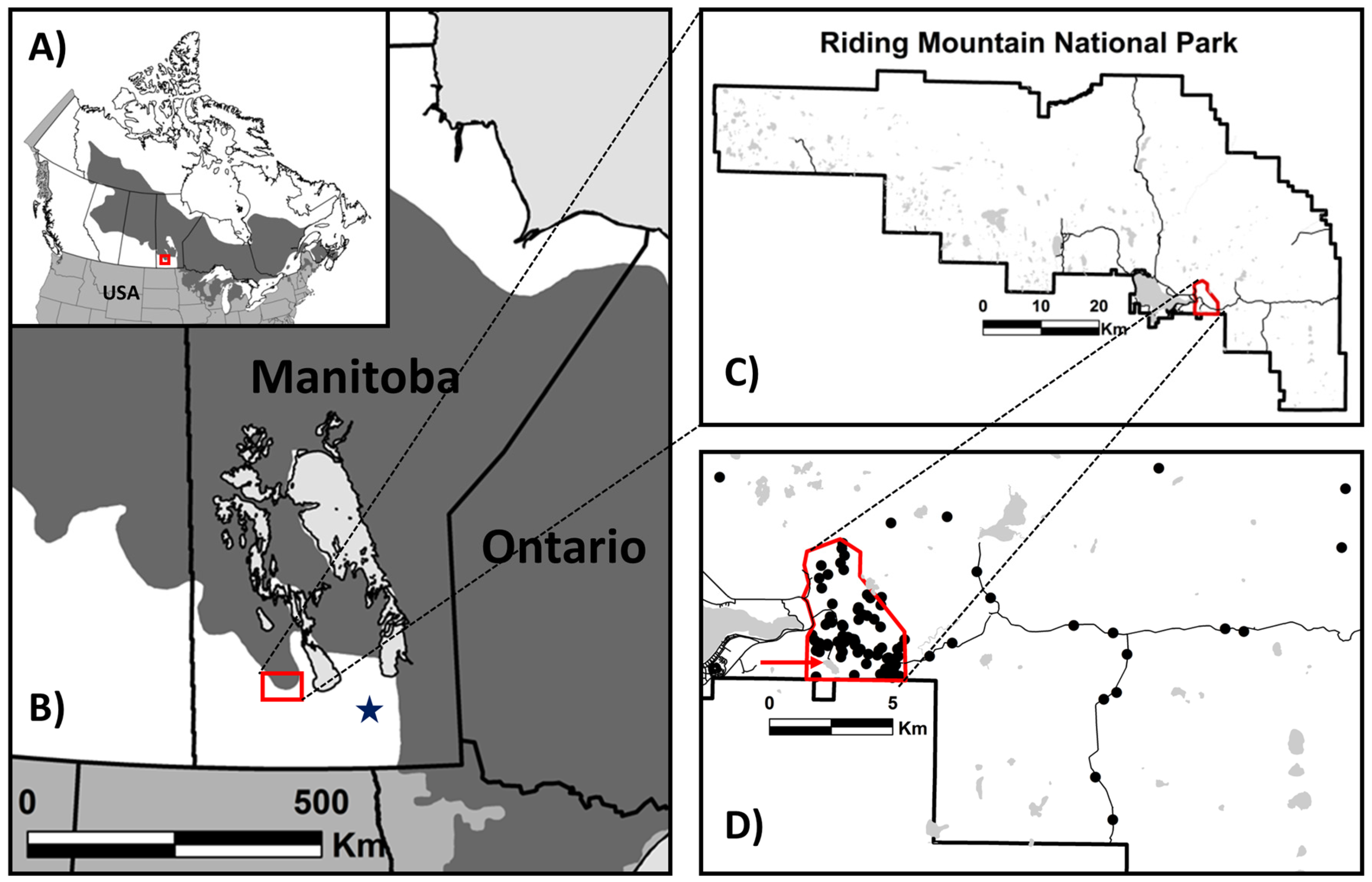
2.1. Study Area

The study area lies within RMNP located in southwestern Manitoba about 250 km northwest of Winnipeg (Figure 1). The park covers 2969 km2 and constitutes the southeastern extent of the Mixed Wood Section of the Boreal Forest Region [39]. Riding Mountain is part of the Manitoba Escarpment, which rises approximately 300 m from the eastern Manitoba lowlands. The park is primarily on the plateau, transitioning from the first prairie level (the Manitoba Plain) to the second prairie level (Saskatchewan Plain). Riding Mountain also forms the southern limit of the Mid Boreal Uplands ecoregion, which also includes Duck Mountain Provincial Forest (DMPF) and Porcupine Provincial Forest (PPF) to the north [40]. Outside RMNP boundaries, the landscape is dominated by agricultural development.
The vegetation of RMNP is characteristic of the mixed boreal forest [20,31]. The present-day boreal forest existed since about 2500 BP with a parkland phase of grassland and deciduous species dominating from 6500 to 2500 BP [41]. In the well-drained upland portion of RMNP the characteristic boreal forest association predominates with trembling aspen (Populus tremuloides Michx.), balsam poplar (Populus balsamifera L.), white spruce (Picea glauca (Moench) Voss), and balsam fir (Abies balsamea (L.) Mill.) dominating. On the sandier, drier, nutrient poor sites, jack pine is found; on moister sites, black spruce (Picea mariana (Mill.) B.S.P.) and tamarack (Larix laricina (DuRoi) K. Koch) increase in dominance. On the exposed edges of the region, bur oak (Quercus macrocarpa Michx.) dominates and, where black chernozemic soils are present, grasslands are embedded in the mixedwood forest. Trembling aspen is the prevalent species across the transition zone, taking the form of small scattered clumps in the grasslands to large stands in the boreal forest [20,31,37,39]. In RMNP, jack pine is confined to an area of approximately 250 km2 in the SE portion (Figure 1D) and is separated from the contiguous boreal forest by about 80 km [20,42].
The RMNP lies within a mid-boreal climate with short, cool summers and cold winters. At Wasagaming (50°39′18′′ N, 99°56′31′′ W, elevation 627.4 m.a.s.l.) for the period 1981–2010, average annual precipitation was 488 mm, with 372 mm falling as rain. June is the wettest month with a mean rainfall of 80 mm [43]. The temperature ranges from −17.5 °C (mean January) to 17.0 °C (mean July), with a mean annual daily temperature of 0.7 °C with extremes ranging from −47.8 °C to 36.5 °C.

2.2. RMNP History

The history of the Riding Mountain region is not fully documented but human occupation started with the retreat of the Wisconsin ice sheet and the formation of Glacial Lake Agassiz. Clovis projectile points were found on Rolling River [44], about 15 km from our study area. The highlands of RMNP, being transitional parkland with both forest and grassland ecosystems, provided optimum resource and habitat availability on a seasonal basis [45]. During the historical period, the resource-rich base was exploited for seasonal rounds and year-round use by First Nations, with Assiniboine, Cree, and Ojibwa having traditionally occupied portions of the park [30,46]. The Ojibwa moved into the area in the 1700s as a response to the fur trade and by the early 1800s were established as the dominant society of the Riding Mountain region [30,32].
In the Riding Mountain region, European settlement, lumber milling, and land clearing occurred from 1870 to 1930. Timber was sought after for building materials, fuelwood, and railway ties [44]. Intensive logging of the southeastern portion of RMNP was triggered by the construction of the railway to Dauphin in the early 1890s [20], with fire being a continuous issue because of its careless use by settlers clearing homesteads [30]. In 1895, the Riding Mountain Forest Reserve was established to protect the remaining forest and timber supply from exploitation and destruction by fire. In 1906, the Dominion Forest Reserve Act was passed marking the beginning of regulated harvesting and organized fire protection. National Park establishment was in 1930, with timber harvest, grazing, and haying continuing up to the mid-1960s. Strict fire prevention/suppression policies were implemented from the time of Forest Reserve establishment, up to 1979. Prior to its regulation, numerous fires from careless slash and disposal operations burned a large portion of the reserve [30]. In the early days, Forest Rangers also frequently created fire guards along the park boundary by burning meadows early in the spring [1].
In Riding Mountain, European settlement, the establishment of Indian reserves in the 1870s and the creation of the Riding Mountain Forest Reserve were all instrumental in restricting First Nations’ use of the area [30]. One reserve at Clear Lake, belonging to the Keeseekoowenin Ojibwa First Nation, fell within the boundaries of the National Park, and in 1936, the people were evicted by Park staff and their homes burned [32,47]. Currently six First Nation communities are located adjacent to or within RMNP on Indian Reserve lands, with the Keeseekoowenin and Rolling River [46] located closest to the study area.

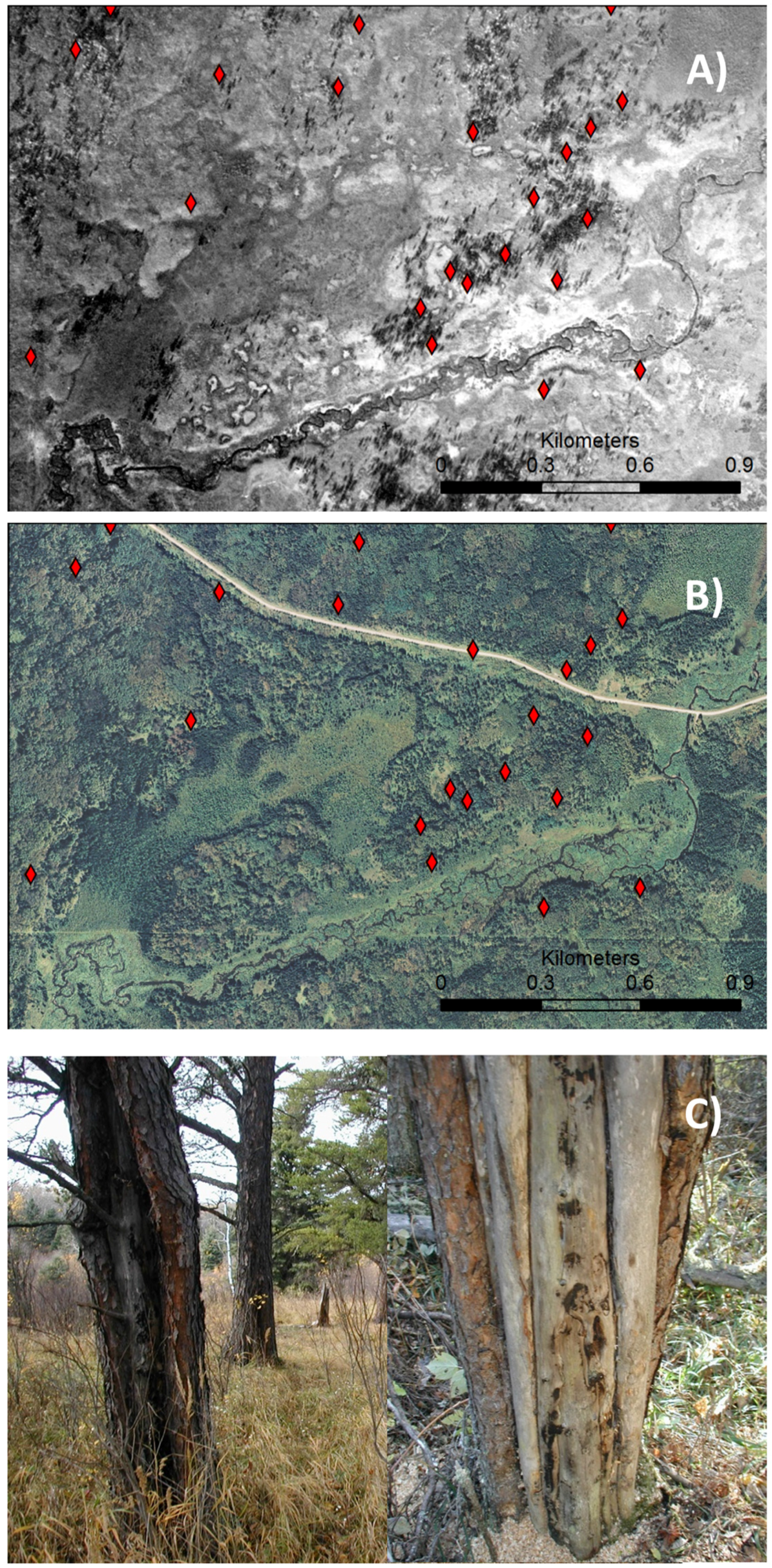
2.3. Field Procedures

Sampling occurred in the southeastern portion of RMNP where jack pine stands predominate. More precisely, sampling mainly took place in Lake Katherine Fire Management Unit (LKFMU; 14U 437000, 5613000), a 30 km2 zone adjacent to Clear Lake on the southeastern portion of RMNP (Figure 1D). The landform is mainly hummocky to undulating stagnation moraine, at an elevation of 620–695 m.a.s.l., and covered by orthic gray luvisol soils. The LKFMU is located on the boundary of the park at the southwestern edge of the jack pine range which was mapped by Zoltai [42].
Data collection for the tree-ring portion of the study came from two independent studies. First a fire study was initiated by Parks Canada in 2008–2009 following standard methods [48,49,50]. Jack pine stands were identified and located from 1928, 1959, 1979, and 2004 aerial photos (Figure 2A,B) and 1937 forest inventory maps and systematically surveyed for evidence of fire disturbance. Cross-sections were taken from the fire-scarred trees and remnants (snags, logs, and stumps) with the most numerous scars (Figure 2C). A total of 89 trees with apparent fire scars were cut. Sampled trees were not evenly distributed across the study area. For each sampled tree, the number of visible scars, number of cross-sections taken, number of pieces per cross-section, height of cross-sections above ground, azimuth in degrees of fire-damaged cat faces, live or dead specimens, and Universal Transverse Mercator (UTM) location were recorded. Fire scars were assigned a compass bearing for the direction of the middle of the arc of the killed cambium. Direction of fire spread was estimated by converting the compass bearing for the fire scar orientation to a cardinal direction. The scars were assumed to have formed on the leeward side of the tree during a fire event [23,51]. Only the first scar was used for the direction analysis because subsequent scarring is often more likely to occur after the first burn due to exposed cambium and thinner bark in the region of the first scar [23]. It must be noted that local fuel conditions, weather, and topography also need to be taken into consideration when analyzing the direction of spread [52].
Second, a study initiated in 2009 by the University of Winnipeg DendroEcology Laboratory (UWDEL) aimed at developing long tree-ring chronologies for multi-species including jack pine [53]. Collected samples included both living and dead jack pine trees distributed within RMNP including LKFMU. Given that the objective of this study was to locate old living and dead trees, five to 10 trees (two cores per tree) were usually sampled per site except in young stands and/or where jack pine trees were in low abundance. Cross-sections were collected from dead material when available. This sampling added 110 trees from sites distributed in LKFMU. Another 100 jack pine trees located outside LKFMU were also used in the development of tree-ring chronologies and their establishment/mortality dates were considered for comparison (Figure 1D).

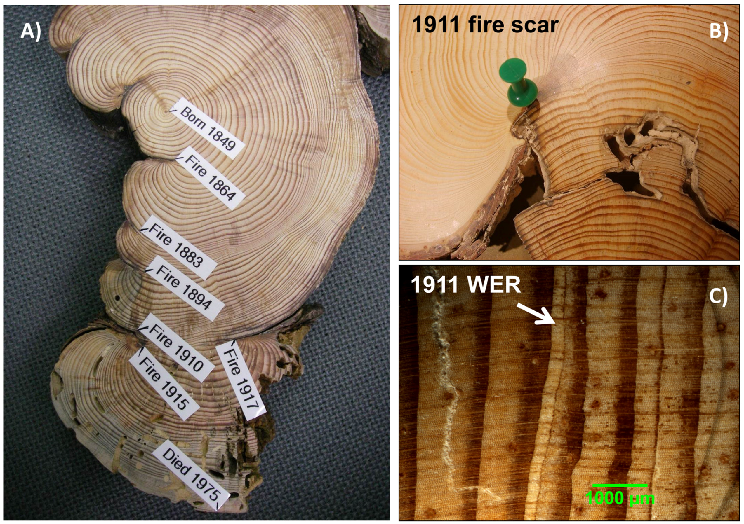
2.4. Fire Scar and Chronology Development

All cores and disks were prepared following standard procedures including drying, gluing, sanding, and crossdating [25,50,52]. Samples were first visually crossdated using pointer years [53]. For each tree, all fire scar dates as well as tree establishment/mortality dates were recorded (Figure 3A). Determining fire years from tree scars followed standard techniques [54], with visual crossdating performed both before and after the events. Injury scars that were discovered a posteriori and did not correspond to a typical fire scar (Figure 3A) were not included. In addition, the relative position of the fire scar within the annual rings was determined (EE: Early earlywood, ME: Middle earlywood, LE: Late earlywood, LW: Latewood, D: Dormant, or U: Undetermined) to assess the season of fire occurrence [55]. Tree diameter (four radii) and tree age at the first fire scar were also determined in the laboratory for each tree bearing the pith to determine the mean minimum tree size (age) at time of injury. This information allowed for determining the minimum tree size for fire survival [51]. For samples that did not intersect the pith, the distance to it was estimated using a circle template that best fit the curvature of the innermost ring [22]. The number of years to the circle center was then estimated using an age–radius curve derived from samples for which the pith was intercepted. All age structures are thus presented to the year despite presenting a slight bias.
Given that the absence of fire scars does not necessarily imply that an area did not burn at a given time [52], white earlywood rings (WER; [56]) were also systematically compiled. White earlywood rings were observed in both jack pine trees bearing fire scars and in unscarred trees within LKFMU (Figure 3B,C). The presence of WER could provide an indication of crown scorch as they have been associated with crown damages during the dormant season, presumably leading to a carbohydrate deficit responsible for the production of earlywood tracheids with thin secondary walls [56]. The absence of WER in jack pine trees growing outside the LKFMU would support this hypothesis.
A tree-ring reference chronology was also developed from jack pine trees collected within and outside LKFMU. For each sample, annual growth increments were measured along two radii at a precision of 0.001 mm using a Velmex measuring stage coupled with a computer. Both visual crossdating and measurements were statistically validated using the program COFECHA [57], which calculates cross-correlations to a lag of 10 years between each individual standardized measurement series and a reference chronology. All measurement series were then standardized using a 53-year (or more flexible for a few series) cubic smoothing spline using program ARSTAN (Ver 4.4, [58]).

2.5. Analyses of Tree-Ring and Climate Data

The software FHX2 and FHAES Ver. 2.0.1 [59,60] were used to develop the fire chronology and summarize fire intervals statistics. Mean fire return interval (mFRI), Weibull mean fire return interval (WmFRI) and descriptive statistics were computed for both the composite and individual tree fire intervals. The mFRI is the average number of years between fire dates in the composite chronology [48,61]. Results are presented for individual tree intervals and for composite chronologies at multiple scales. Fire statistics for LKFMU were computed for three sets of data: (i) entire fire years (no filter); (ii) fire recorded by 10% or more of the sample trees; and (iii) fires recorded by 25% or more of the sample trees. This approach aimed at highlighting spatial variation among locations, assuming that fires present in more than 10% and 25% of the samples were more widespread [62]. The FHAES program was also used to analyze the seasonality of fire and analyses.
To determine the potential impact of climate on LKFMU fire regime, the association between the jack pine tree-ring chronologies and the reconstructed Canadian Drought Code (CDC) was assessed using correlation analyses. This analysis was done using the CDC derived from a network of chronologies developed for DMPF located about 125 km north of RMNP [63]. Running correlations were also used to assess the association between LKFMU jack pine chronology and the one developed outside LKFMU.

2.6. Lake Katherine Charcoal Sediment Analyses
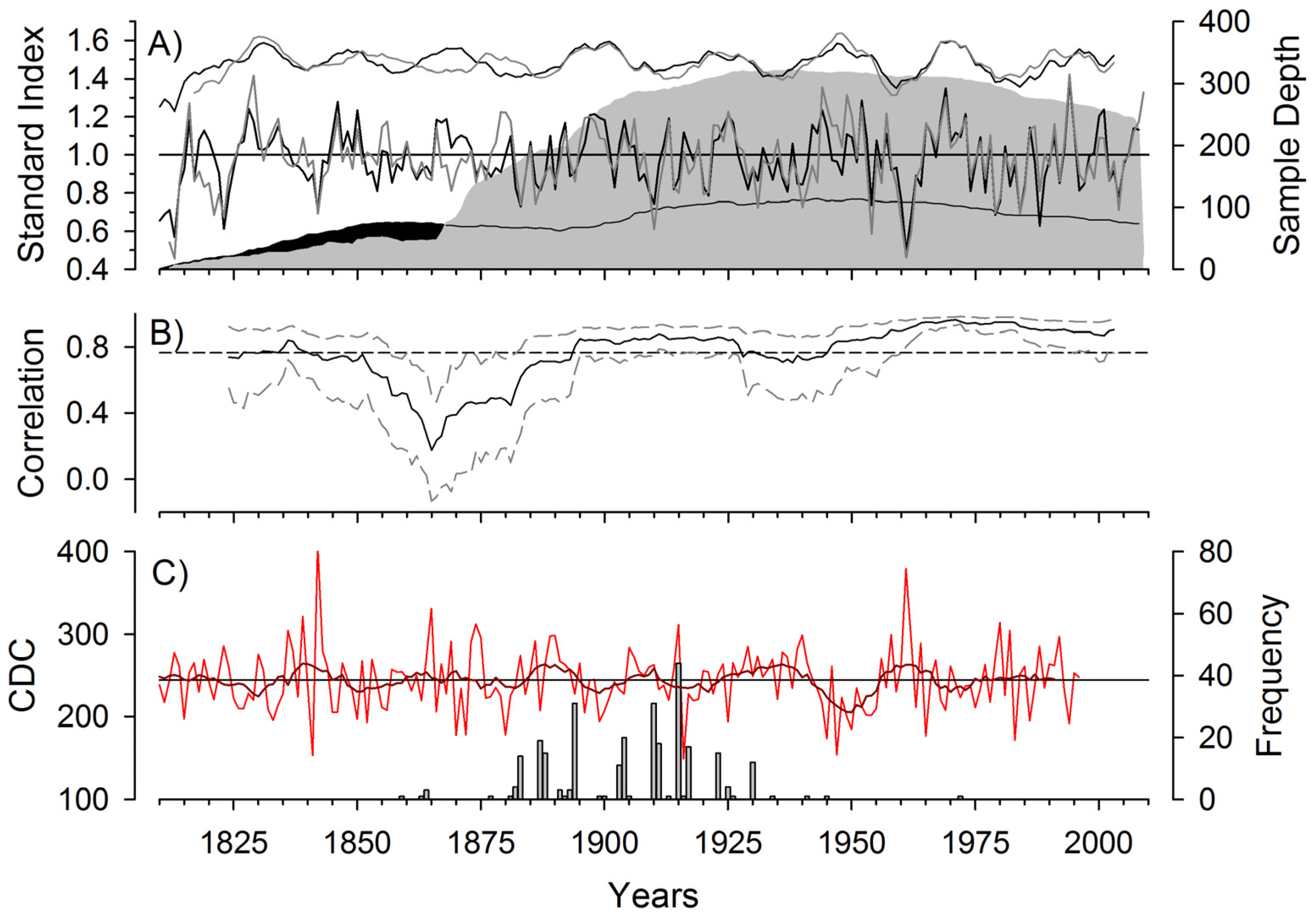
In addition to the tree-ring studies, a paleoecological study was conducted in the winter of 2010 to quantify macroscopic charcoal particles in Lake Katherine sediment. Lake Katherine is located in the southwest section of LKFMU (Figure 1D). It has an area of 26.7 ha and a depth of 8.5 m [64]. Lake Katherine is also a small closed basin, presumably ground water fed, with no significant water courses in or out. Unconsolidated sediment was extracted with a Glew gravity corer [65] down to 40 cm depth and dated with 13 210Pb samples using a constant rate of supply model [66,67]. The procedure followed for 210Pb dating was that outlined by MyCore Scientific Inc., (Dunrobin, ON, Canada). (http://mycore.ca). Underlying consolidated lake sediments were extracted with a Livingston Piston corer [68] down to 673 cm and dated with four 14C samples. Dating of the deeper sediments was undertaken on organic material using the 14C Accelerator Mass Spectrometry (AMS) method [69] following the procedure outlined by Beta Analytic (Miami, FL, USA) (http://www.radiocarbon.com). In this study, the upper 1.4 m of sediment was analyzed and the age-depth model was thus derived using the first two radiocarbon dates and the first eleven 210Pb dates. The two 14C dates were derived from (i) charred spruce needles located at a depth of 259 cm and dated to 1710 BP ± 30 years and (ii) from a piece of wood at a depth of 476 cm and dated to 5035 BP ± 30 years. The dating of the sediment (210Pb and 14C) allowed the development of an age-depth model providing a calendar date for each centimeter of the sediment core. The age-depth model first required 14C dates to be calibrated using program CALIB 7.0 [70] based on IntCal13 [71]. An age–depth model was developed using MCAgeDepth program [72] following 1000 Monte Carlo simulations to generate confidence intervals (Figure S1).
The Lake Katherine charcoal record was generated by sub-sampling the upper 140 cm of sediment (first 105 cm) at ~1 cm intervals and the remaining sediment at ~4 cm) with a calibrated (1 cm3) brass subsampler. Samples were soaked in a 10% Sodium Pyrophosphate solution for two days before being wet-sieved at 125 microns. Next, the sieved residue was soaked in a 3% Hydrogen Peroxide solution for six hours before again being wet sieved at 125 microns [73]. Residues were then transferred to a channeled Bogorov tray, where charcoal pieces >125 microns were identified and counted using a stereomicroscope at 10–50× magnification. Charcoal particles were compiled using three size classes (125–250, 250–500, >500 microns), with the total count representing their sum. Among the particles, the number pertaining to the grass cuticle morphotype [74] was also determined. Based on the age–depth model, total charcoal counts were reported as charcoal accumulation rate (CHAR, particles/cm2/cal year).
The CHAR series was analyzed using the CharAnalysis program [75] to identify fire events and calculate FRIs. In this study, the period ~1450–2010 CE was analyzed and CHAR series was interpolated (Cinterpolated) to equal time steps (four years, i.e., median sample resolution), containing a low frequency (Cbackground) and a high frequency (Cpeak) component [76,77]. The Cbackground was determined using the Lowess smoother robust to outliers using a window width of 300 years. Cpeak series were identified by subtracting Cbackground from Cinterpolated. The Cpeak series were further decomposed into a Cnoise and Cfire, with the latter representing in theory significant peaks associated with local fires [66,76]. The Gaussian mixture model was used to determine Cnoise distribution and a locally defined threshold was used to identify significant Cpeak. The 90th, 95th, and 99th percentiles of the Cnoise distribution were considered as a possible threshold separating Cpeak into ‘fire’ and ‘non-fire’ events. The minCountP value was set to 0.99 in all runs given the short FRIs characterizing the recent RMNP fire history. The final determination of the peak analysis parameters were based on maximization of the signal to noise (SNI) index (typically >3) and goodness of fit (GOF; p < 0.05) [66,77].

3. Results

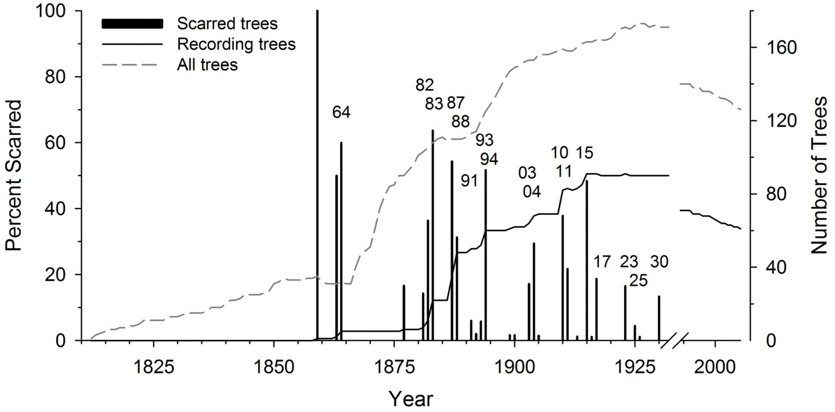
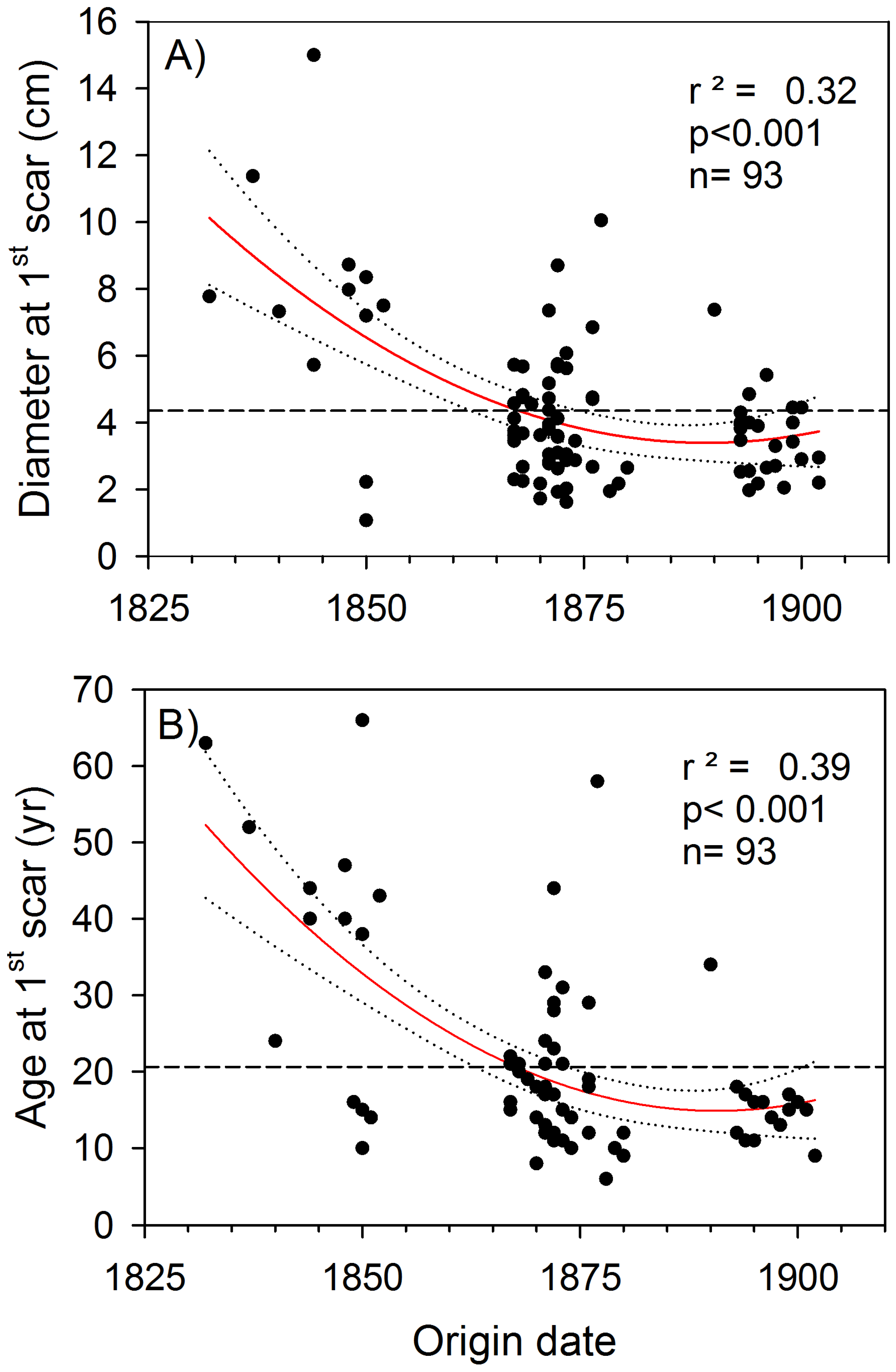
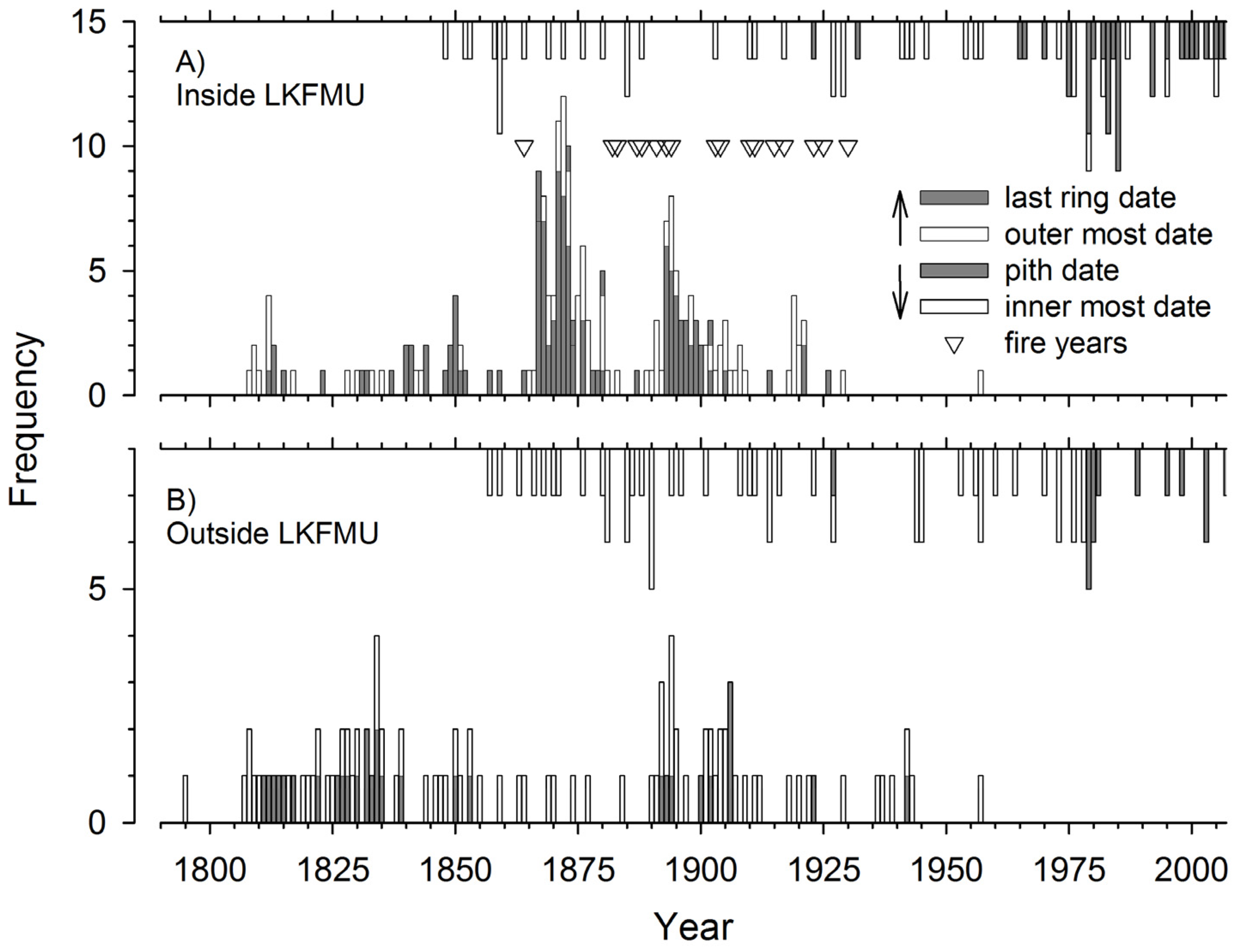
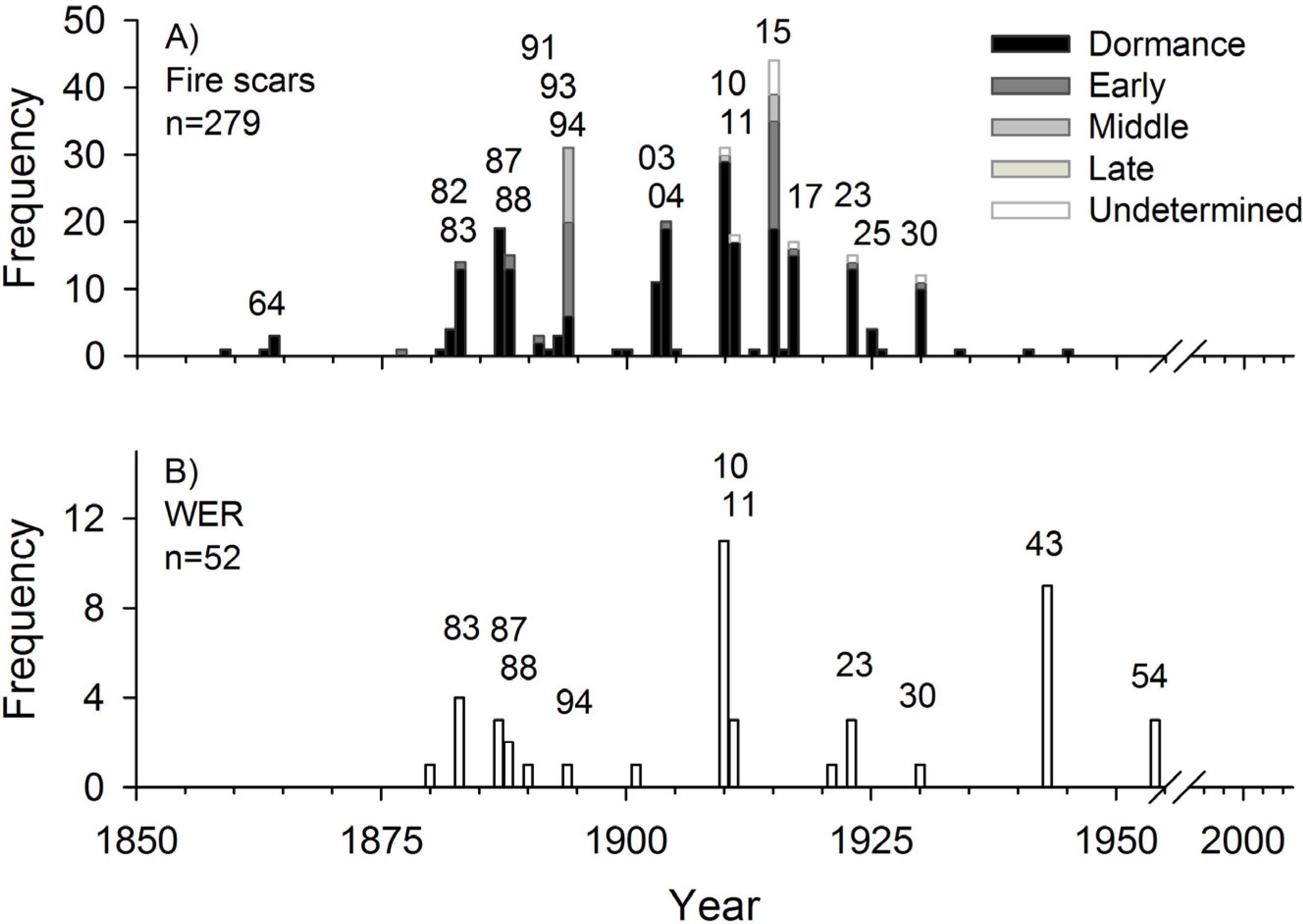
3.1. Recent Fire History in LKFMU

The tree-ring reconstructed fire history covers the period 1812 to 2009 (Figure 4). Two hundred and seventy-nine crossdated fire scars were recorded. A total of 28 fire years were recorded, with the first event recorded by two trees or more being observed in 1864 and the last one in 1930. During this period, 17 fires were recorded by more than two and up to 44 scarred trees: 1864, 1882–1883, 1887–1888, 1891, 1893–1894, 1903–1904, 1910–1911, 1915, 1917, 1923, 1925, and 1930. More than 48% of the 91 recording trees displayed a fire scar in 1915 (Figure 4). Prior to 1859 (one scarred tree), no fires were recorded despite sample depth reaching about 20 trees. The 1864 fire was recorded by few trees and this event was followed by an important recruitment pulse lasting from about 1865 to 1875 (Figure 4). The 1880 decade also marked an increase in recorder trees, with 14 trees recording the 1883 fire. The 1894 and perhaps 1887–1888 fires were also followed by important jack pine recruitment, occurring within a decade of few or no fires. Of the recorded fires, numerous ones also occurred consecutively (e.g., 1882–1883, 1887–1888, 1893–1894, 1903–1904, and 1910–1911; see Figure 4).
A total of 181 fire intervals originating from fire scars were recorded in LKFMU (30 km2) ranging from 1 to 38 years with a mean fire return interval (mFRI) of 10.98 years and a Weibull mean fire return interval (WmFRI) of 11.03 years (Table 1). During the period 1850–1930 the mFRI derived from composite chronologies (no filter, ≥10% and ≥25% of the tree scarred) was 2.63, 4.18, and 5.60 years, respectively. The WmFRI values were 2.66, 4.19, and 5.62 years, respectively (Table 1). No fire has been recorded in LKFMU over the last 85 years (a fire-free period) corresponding to the period of First Nations land use exclusion, the National Park establishment, and active fire exclusion.
The jack pine age structure (establishment/mortality) within LKFMU indicated continuous recruitment since the early 1800, with important pulses being observed in the late 1860s and the late 1890s (Figure 5A). These establishment peaks corresponded to periods with longer fire intervals that followed the 1864 and the 1894 fires (Figure 5A). Establishment was also observed around 1810, 1850, and 1920. While our study did not include the quantification of recruitment after 1930, qualitative field observations indicate little to no jack pine regeneration in LKFMU. Regeneration and infill of forest gaps is mainly associated with white spruce and trembling aspen. Jack pine mortality has also been continuous during the reference period and increasing mortality was observed since the late 1970s (Figure 5A). The jack pine age structure outside LKFMU revealed distinct features (Figure 5B). Little indications of past fires were observed in these sites with the exception that some did burn in the spring of 1980 (field observations). Outside LKFMU, recruitment pulses may have occurred in the 1810s, 1830s, and 1890s, as indicated by pith dates. Similarly to LKFMU, jack pine mortality also increased around the late 1970s (Figure 5B), with that observed in 1980 being a consequence of a documented forest fire burning outside LKFMU.
In LKFMU, jack pine trees recorded their first scar at a mean diameter of 4.3 cm at cross-section height (standard deviation: 2.33, range 1.07–15.00, n = 93) and at a mean age of 20.61 years (standard deviation: 12.07, range 6–66, n = 93). These numbers also reached lower values during the two periods of clustered fire scars starting in the early 1860s and late 1880s (Figure 3A; Figure 6). The diameter (age) distribution at which trees recorded their first fire scar also indicated a significant decrease with time in those parameters, suggesting an intensification of fire frequency in the late 1800s (Figure 6).

3.2. Seasonality and Direction of Fires

The seasonal analysis of fire years indicated that the great majority of the fires were recorded in the dormant season (79.6%), followed by earlywood fires (14.5%; Table 2). Overall, 92.1% of the scars indicate dormant season or spring fires. The majority of the scars identified to the dormant season also had a few trees recording them in the earlywood (Figure 7A). Intriguingly, the fire years 1894 and 1915 stand out with scars recorded from the dormant period to the mid-earlywood position (Figure 7A). Numerous fire scar years were also associated with the production of WER (Figure 7B). Agreement between both proxies was observed in 1883, 1887–1888, 1894, 1910–1911, 1923, and 1930, whereas the WER years 1943 and 1954 did not correspond to any fire scars (Figure 7B).
The distribution of fire-scarred trees in LKFMU revealed large spatial variability from one fire to another (Figure 8). For example, the 1888, 1903, and 1911 fire scars were mainly restricted to the southeastern portion of LKFMU. Scarred trees were also observed close to Lake Katherine in 1864, 1883, 1887, 1894, 1904, 1910, 1915, and 1917. The distribution of WER also matched that of fire scars very well. While few scars dating from 1864 were found, the 10-year period following this event was characterized by intensive jack pine recruitment. The 1894 (and possibly 1887–1888) fire was also followed by abundant recruitment. Some of the larger fires in LKFMU were observed in 1864, 1887, 1894, 1910, and 1915. The frequency of WER was highest in 1910, a year corresponding to widespread fire occurring mainly during the dormancy period. The 1915 fire was widespread and apparently burned for a long period in the growing season, having been recorded from the dormant season to the early and mid-earlywood (Figure 7). Interestingly, the spatial distribution of fire scarred trees also suggests that LKFMU may have been burned over a two-year period. For example, the position of the scarred trees in 1887–1888, 1903–1904, and 1910–1911 suggested that different portions (northwest versus southeast) of the area were burned each year (Figure 8). In LKFMU, the wind rose with the frequency of spread directions suggested the prevailing fire spread was from the southwest (Figure 8).

3.3. Drought and Fire

The tree-ring chronology developed from jack pine trees from inside and outside LKFMU covers the period 1812–2008 and 1804–2008, respectively (Figure 9A). These chronologies were significantly correlated (r = 0.798, p < 0.001, n = 189) for the period 1820–2008 and they were both also significantly correlated with the reconstructed CDC index (r = −0.513 and r = −0.504, p < 0.001, n = 177) for the boreal plains of Manitoba (Figure 9). The running correlation between the inside and outside LKFMU chronologies also presented a strong degradation of the common signal from about 1840 to 1910; the correlation reached a minimum during the interval 1855–1904 (Figure 9B). In LKFMU, fire years occurred when the CDC values ranged from 194 to 312, indicating that fires occurred in years when the drought code was high to extreme [78]. Among all fires, the 1915 fire occurred in a very dry summer (Figure 9C).

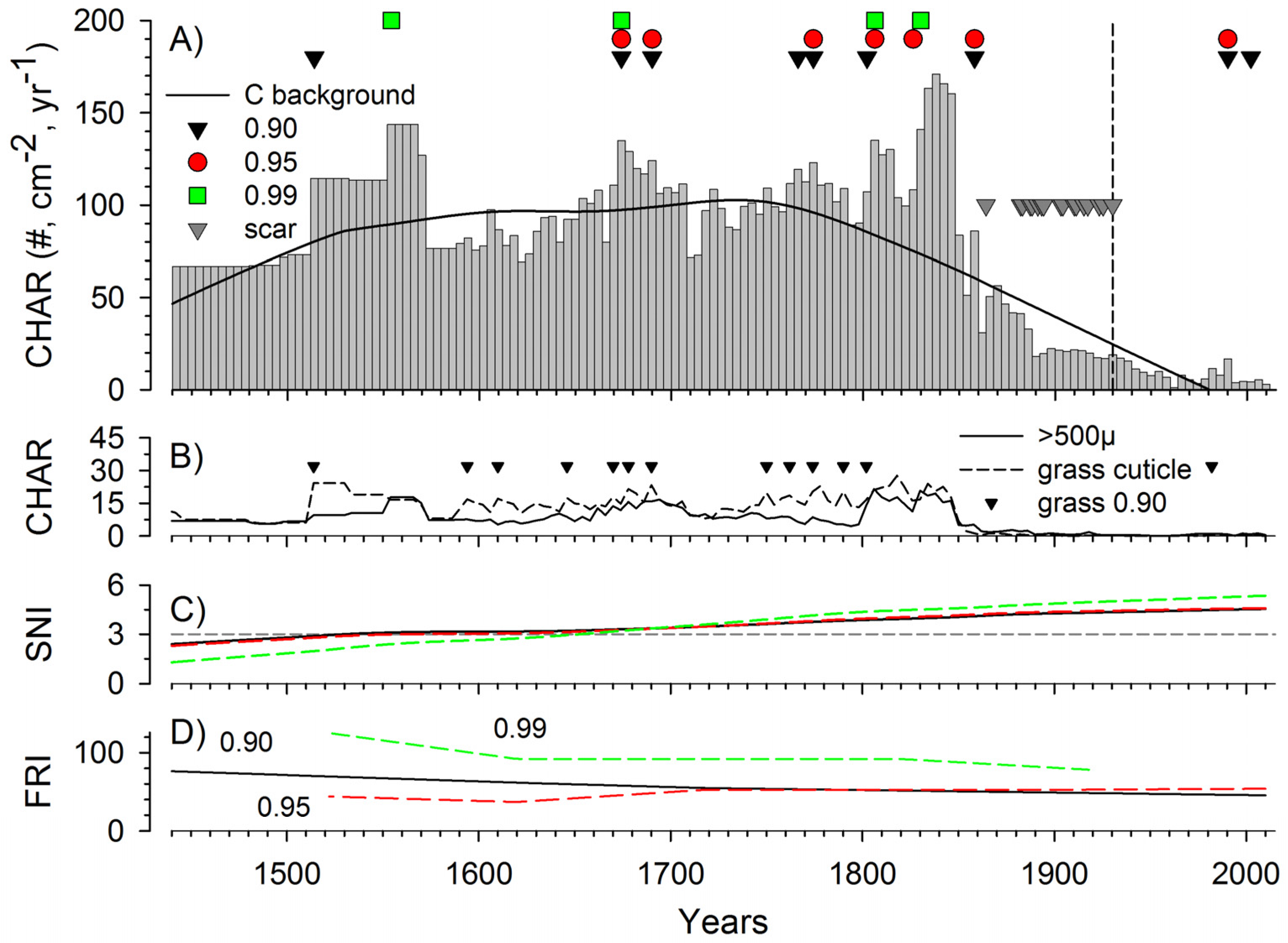
3.4. Lake Katherine Charcoal Chronology

The CHAR (Charcoal Accumulation Rate) profile for Lake Katherine indicated a stepwise and substantial reduction in charcoal concentration starting around 1850 (Figure 10A). CHAR from the early record until about 1850 was relatively stable, with a mean count of 100.5 particles (cm−2·year−1). From 1850 to 1930, CHAR decreased to a mean of 32.8 particles and after RMNP establishment (1930), it decreased to a mean of 7.9 particles. After about 1850, both the contribution of grass cuticles and of large charcoal particles (>500 microns) to total CHAR also decreased abruptly (Figure 10B). Over the period analyzed, the number of fire events detected varied according to the threshold used (90th, 95th, and 99th percentiles). The number of fires identified was 9, 7, and 4, respectively (Figure 10A). With five fire intervals detected prior to 1850, the mFRI (90th percentile) was estimated to be 58 years, ranging from 13 to 113 years. Numerous fire events were also detected using the grass morphotype CHAR and the 90th percentile threshold (Figure 10B). The CHAR peak analysis in this study failed to identify the numerous fires that occurred between 1850 and the RMNP establishment (Figure 10A). Between 1850 and 1930, fire events at the 90th percentile were detected in 1858, 1990, and 2002, whereas at the 95th only fires dated to 1858 and 1990 were detected. A fire in 1982 was identified from the grass particle CHAR (Figure 10B). At the 99th percentile, two fire events were detected in the early 1800s. The smooth FRI (600 years smoothing) associated with each percentile indicated long-term FRIs ranging from about 50 to 133 years (Figure 10C).

4. Discussion

4.1. LKFMU Fires: European Exploitation/Settlement Period (1850–1930)

The tree-ring evidence suggests that a mixed fire regime may have dominated LKFMU, with dominance of frequent low intensity surface fires during the period 1850–1930. Major recruitment pulses followed two of the largest, most severe fires (1864 and 1894) and periodically followed a number of less severe fires. The absence of repeated and/or widespread fires in the decade following these two fires may have been determinant of successful jack pine establishment. The fire regime during this period had characteristics of both grassland and boreal forest—a transitional regime where ecosystems with frequent light surface fires meet ecosystems with less frequent, high intensity, stand-replacing fires. The LKFMU, due to its position between grasslands and boreal mixedwood, may present characteristics of both regimes [79]. Some of the fire years (e.g., 1864 and 1894) also corresponded to prairie fire years documented by Rannie [80], but it remains unclear whether these would have reached Riding Mountain. During this period, the mFRI was among the shortest documented for jack pine forests (e.g., [18,81,82,83,84,85]).
This period of intense fire activity, however, is not typical of boreal mixedwood and coincided with exploration, the demise of the fur trade, First Nations displacement, European settlement, and forest reserve establishment. The causes for these frequent fires can be traced in the local history and are similar to findings in other areas and parks along the southern edge of the boreal forest [10,11,18,25,26,86]. Conducting forest surveys from 1906 to 1908, Dickson [35] described the fires and resulting forests of the Riding Mountain Forest Reserve. He wrote that “The damage done to this reserve by fire has been enormous. Large areas have been crossed and recrossed by the most destructive fires. For miles and miles alongside the old Indian trails stretch open prairies and desolated wastes of blackened stumps”. He specifically makes reference to the study area, “the work of recurrent fires is apparent over large areas, shown particularly in the denuded semi-prairie conditions all about Clear Lake” and further added that “… fire in the previous 20 years (were) due to careless lumber men, settlers, half-breeds and Indians” adding that “ground fire around the outskirts of the reserve, especially those bordering settlement, are annual inflictions” [35]. Forest rangers also created fire guards along the park boundary, with mention of burning 90 miles (~144 km) of meadows around Riding Mountain in 1911 [87].
These descriptions are sustained by the 1929 aerial photos, indicating that LKFMU was characterized by grassland, aspen parkland, and scattered jack pine stands (Figure 2). Interestingly, despite CHAR peak analysis being unsuitable to capture fires that occurred during this period of very short fire intervals, it corresponded to a drastic decrease in CHAR, suggesting a reduction in biomass burned and/or fire intensity in close proximity to the lake. The few CHAR peaks observed (e.g., 1858) could reflect some of the largest fires that occurred and this within the built-in confidence intervals associated with sediment dating. Given the robust dating of the upper sediment, the low production of charcoal by low-intensity fires (low CHAR values) may have limited the ability to detect fire peaks. Fire event detection from CHAR was reported to work best when large, low-frequency, and high-intensity fires dominate a landscape and also when FRI is at least five times that of the sediment sample resolution [76]. In our case, this would represent fire intervals of about 20 years. Taphonomic processes related to transport and deposition of charcoal may also be involved. Factors like minimal relief and small watershed may have played a role in delaying the delivery of charcoal to Lake Katherine, thereby smoothing the signal associated with low-intensity fires.
Outside LKFMU, the jack pine age structure displayed little similarity with that of the LKFMU. The scarce occurrence of fire scars in these sites suggests the predominance of a crown fire regime. This area was, however, presumably also affected by anthropogenic activities and the logging impacts on these jack pine forests remains unknown. Maps of logging occurrences in the area between 1900 and 1920 exist [20] but little detail was given on species, exact locations, or volumes removed. The high demand for jack pine railway ties in the early 1890s was associated with intensive logging in the southwestern portion of Riding Mountain [20]. No evidence of logging was, however, observed in the field. According to historical accounts, these jack pine stands could have burned in ca. 1830 and 1895 (supported by recruitment centered around these dates) during fires that affected the eastern portion of RMNP [35], and post-fire logging could have removed this evidence. The differences in fire dynamics within and outside LKFMU further suggest that the period 1850–1930 was likely a time of First Nations fire use that transitioned into a time of European fire use. The open forests/grasslands were easier to burn than closed forests and Europeans may have intensified their imprint on an already existing landscape.

4.2. LKFMU Fires: Fire-Exclusion Period (1930 to the Present)

Since the creation of RMNP in 1930, no fire has occurred in the LKFMU [30,36]. Generally the fire-exclusion period corresponds to park establishment, changing land use, end of resource extraction, and park management. This lack of fires also corresponds to a drastic reduction in CHAR. About 200 km southwest of RMNP, a quasi-total elimination of grass fires was also documented following Euro-Canadian settlement [88]. There are a number of possible explanations for the length of the current fire-free interval in LKFMU: (i) due to land use change, fires no longer start in the south and spread northward into the park; (ii) fire prevention and suppression policy within the park has eliminated fire; and (iii) the 20th-century climate may have been less conducive to fire than in the past. While no fires were observed in LKFMU, a number of smaller fires were observed elsewhere in RMNP during the 1930s and 1940s and these were thought to have been deliberately set by farmers [20]. The recent fire record of RMNP (1937–2015) has 382 fires burning a total of 973 km2 (Cornelsen, unpublished data). Only 7.3% of the fires and 1.4% of the area burned was attributed to lightning fires, with the remainder being human caused. Lightning fire ignitions have been uncommon despite the region receiving an abundance of thunderstorm activity (30 thunderstorm days per year, or 1.5–2.0 lightning strikes/km2/year) [89]. Despite active fire suppression, large fires have occurred in RMNP in 1940, 1961, and 1980, corresponding to major drought years (Figure 9C). The last significant wildfire occurred in May 1980, when a human-caused fire burned 200 km2, including most of the parks’ mature jack pine stands located outside LKFMU. The CHAR analyses identified a fire in the late 20th century (1982, 1990, or 2002, according to the model) and could reflect a small input from the 1980 fire. This 1980 fire came within 3 km of Lake Katherine and outside its drainage basin, with the lake being downwind for the three days of major fire spreads. Extremely low CHAR background during this period of fire suppression could have enhanced the ability to record fire events, although the signal may be influenced by the addition of even a few dozen charcoal particles that could also be attributed to other factors such as erosion, heavy rain, and sediment delivery.

4.3. LKFMU Fires: Early Period (1450–1850)

The jack pine trees that were established in LKFMU prior to the 1860s did not record any fire scars (or datable ones), but the tree samples for which the pith was present suggest continuous recruitment, with most of these trees dying in the late 19th century. The sparse indications left by jack pine trees that were established in the early 1800s also suggest that fire intervals may have become shorter in the mid-1850s, with trees registering scars at a younger age and a smaller diameter. Supporting this interpretation is the sudden decrease in CHAR from the mid-1800s. The high and relatively stable CHAR values observed during the period 1450–1850 suggests increased fire intensity and/or biomass burned compared to the period 1850–1930. The best estimate of the FRI during this period varies from about 50 to 133 years. Because of the stepwise change in sedimentation rate at the interphase of the two sediment cores, we exercise caution in over-interpreting the increase in CHAR that occurs abruptly at this transition. Interestingly, however, large CHAR peaks occurred in the late 1700s, early 1800s, overlapping the period when Anishinaabe people moved into the Riding Mountain region in the 1700s and were established as the dominant society by the early 1800s [30,32]. We speculate that both the high CHAR values observed during this period as well as the high grass morphotype values may be indicative of recurrent burning to the lake margins, increasing charcoal inputs and background. The practice of burning around lakes, streams, and rivers increases access to numerous plant species and other resources [90]. In Alberta, systematic burning of meadows, river edges, lake shores, and other areas by indigenous peoples was also reported to increase productivity and biodiversity at the landscape level by creating small patchworks of early successional plant communities within later seral stage communities [91].
Little information could be gathered regarding the magnitude of the eco-cultural use of fire by First Nations, Metis, and early white settlers prior to 1850; both uncertainty and controversy exist regarding their impact [1,30,87]. Numerous historical accounts of eco-cultural fires burning in the southeastern Canadian prairies from the latter 18th to the latter 19th century exist [80,88]. Indigenous burnings to promote berry patches may have involved burning on a cycle of 3–5 years, whereas regeneration of aspen and willows around beaver ponds may have been maximized with a 10–12-year fire interval [90,91]. In addition, a substantial number of forest fires in the boreal must have originated from campfires, signal fires, or fires set for the gumming of canoes, hunting, in warfare, or combating insect pests [92]. Numerous examples of the use of prescribed burning by indigenous and white people during the fur trade period in Alberta were also documented [93].
Little information is available describing the use of fire by First Nations in LKFMU. Historical accounts indicate that the occupation of the area by Anishinaabe people started around 1800–1850. In a study of the traditional land and resource use of Riding Mountain, Lake Katherine was often referred to as being a highly valued and visited place [46]. Berries were picked and roots harvested, and people stayed and camped by the lake. In this resource-rich environment, man-made fire was not referred to as a management tool [46]. The author speculated that traditional ecological knowledge of fire usage has been lost given evidence of fire usage by Anishinaabe First Nations [46]. Miller [94] documented the use of controlled fire by the Pikangikum First Nation (Anishinaabe) in northwestern Ontario and the fact that this practice was largely stopped by provincial forest managers in the 1950s, leading to young people having little knowledge of these former fire practices. This pattern appears to be similar to that observed by Tardif (unpublished data), who observed a drastic reduction in fire scars in a disjunct red pine (Pinus resinosa Ait.) stand located on Black Island, Manitoba. This reduction in fires coincided with the settlement of the mainland in the late 1870s, the exploitation of Black Island resources, the opening of a pulp mill in Pine Fall in 1927, and the creation of Hecla Provincial Park in 1969. Despite the Hollow Water Anishinaabe referring to the area as a berry picking ground [95], no recollection of past fire usage was communicated.

4.4. Seasonality and Directional Spread of Fire

In LKFMU, the majority of fire scars occurred during the dormant season and the earlywood portion of tree rings. Local observations about cambial growth initiation in jack pine trees from RMNP (Cornelson, unpublished data) and elsewhere [96,97] indicate that production of earlywood tracheids began in late May and that of latewood in mid-July. Fire scars formed in the dormant season may thus be from late April or early May and those in the earlywood from late May or early June. Dormant season fires were assumed to be spring fires due to the relative absence of fires or area burned in the fall in the recent written fire record (Cornelsen, unpublished data). This interpretation is supported by the occurrence of WER, which was often synchronized with fire years, and this anomaly has been associated with crown and/or foliage damage during the dormant season prior to the onset of radial growth [56]. Their high frequency in fire years suggests crown damages associated with low intensity fires prior to the onset of growth. This interpretation is also supported by the absence of WER in jack pine trees growing outside the LKFMU. This is in contrast with the WER of 1943 and 1954, which were also observed outside the LKFMU (and in DMPF and PPF), and were most probably associated with winter and/or spring regional frost damages [56]. Fire data indicate that RMNP has a spring-dominated fire regime, with 6% of fires occurring in April, 90% in May, and 3% in June [36]. In RMNP, the dormant season fires and early spring fires (May) are typically outside of the main lightning season.
The direction associated with the fire scars indicated that in the LKFMU fires mainly spread into the park from the S/SW. This direction of spread is consistent with historical accounts of fires coming off the prairies and up into mountains [34] and the fact that LKFMU is proximate to grasslands, travel corridors, areas of occupation, and hunting/gathering locations of the Anishinaabe First Nations [46].

4.5. LKFMU Fires, Regional Climatic Influences, and Implications for Management

The seasonality results, the recent fire record, and the historical fire record support the suggestion that the majority of the LKFMU fires were human caused. No distinction was made as to exact cause and whether the fire was accidental or purposeful. The period 1850–1930 was characterized by frequent fires and coincided with First Nations fire use transitioning into European settlement and fire use; it is not necessarily typical of boreal mixedwood fire regimes. Interestingly, none of the major fire years corresponded to major light ring years observed in RMNP (1866, 1868, 1873, 1875, 1880, 1885, 1890, 1892, 1907, 1935, and subsequent; [53]), which suggests that cooler-than-average summer temperatures (late spring and late summer) may not have been conductive to natural or anthropic fire ignition. None of the fires were also associated with major flood years of the Red River (1747, 1762, 1826, 1852, 1862, 1950, and 1997; [98]) indicating that heavy snow load in winter and/or a wet spring may also not have been conductive to spring fire ignition. Some of the major fire years (1864, 1894, and/or 1915) were, however, associated with dry conditions [99,100,101]. Some of these fire years were also observed among others in Saskatchewan [102], Manitoba [25,27], Minnesota [81,103], and Ontario [104,105,106]. Within central North America, the Hudson Bay Company’s archival records for northwestern Ontario indicated that the 1860s marked a transition towards increasing fires up to the end of the 19th century [104].
In LKFMU, the potential implications of the long current fire-free interval (fire exclusion) are greater stand density, accumulation of fuel on the forest floor, encroachment of fire-susceptible species, loss of jack pine and associated species, and increased vulnerability to a stand-replacing fire of high severity and a post-fire vegetation community outside the natural range of variation in reference conditions [7,20,107,108]. Our results indicated that jack pine mortality has been increasing, with the fire-free interval nearing the end of the normal life expectancy of individual trees. In LKFMU, small (young) trees rarely had scars because their cambium may be killed by a passing fire or their foliage killed by crown scorch [51]. Results support this view, with few trees <4.3 cm in basal diameter (<20.6 years) bearing a first fire scar. These findings have implications for the application of prescribed fire treatments. Fire intervals should be short enough to promote regeneration, but sufficiently long to allow survival and continued recruitment [35,79]. Jack pine is known as a prolific cone producer, with trees bearing cones as early as 6–8 years [13,37] and viable seeds being reported in 3–5-year-old stems, with 50% seed germination in 20-year-old stands [16]. Jack pine growing in the open also produced more seeds than in closed stands, where cones may be initiated between 10 and 25 years on average, with the greatest production occurring in 70- to 80-year-old stands [14]. Young jack pine trees also mainly produce non-serotinous cones, with serotinous ones being produced when trees reach a diameter at breast height of about 10 cm [109].
A proposed management prescription for fire restoration in LKFMU would need to adopt a diverse approach with a mixture of intervals, severities, and sizes that create a patchy mosaic. This could be produced with an FRI of 5–10 years, burning only portions of the 30 km2 study area in any one year, with low-intensity surface fire. This is supported by the presence of scars and of WER, suggesting that many jack pine trees recorded and survived crown scorching without recording scars. Once every 25–30 years (or longer), the application of higher intensity surface fire burning larger areas would create preferential regeneration conditions, assuming an adequate seed bank is present. More frequent surface fire of any intensity could be used to manage fuel loads and increase crown fire resistance, subsequently reducing the risk to adjacent property. Such a prescribed burn program would emulate a dynamic fire regime (historical and anthropogenic) with regards to fire frequency, severity, seasonality, patch size, and extent that can adequately regenerate the jack pine stands and maintain functional ecosystems. Ecological and social objectives could be achieved by restoration of historic fire regimes, even if they are anthropogenic in nature. Such a fire regime would also be in line with current park management objectives. Given the proximity of LKFMU to significant values at risk (Wasagaming and Onanole communities), a frequent, low-intensity, surface fire regime would be safer to manage than an infrequent, high-intensity, crown fire regime (typical of boreal jack pine). From an ecological perspective, the number of small diameter and/or young jack pine trees that survived frequent surface fires until recently indicated successful recruitment.

5. Conclusions

The LKFMU was characterized by short FRIs during the end of First Nations occupation and European settlement period and a long fire exclusion period following the establishment of RMNP. The fire regime in jack pine stands located within LKFMU and at the southern extent of their range indicated that during the period 1850–1930 a surface fire regime predominated with short FRIs. Fire severity was presumably mixed, with two fires (1864 and 1894) accounting for most of the recruitment. Part of LKFMU did burn almost every other year, with the two periods with longer interval corresponding to most of the recruitment. While acknowledging that some of the fires detected may have been of climatic origin, we speculate that the bi-annual nature of many fires may have corresponded with the needs of First Nations or European settlers. Given the age of the jack pine trees, little information is available prior to European settlement, rendering it difficult to assess the use of fire by First Nations.
Despite its limitation in temporal range, the tree-ring data suggested that longer FRIs may have existed in LKFMU prior to the 1850s. In this study, an imperfect calibration existed between fire years derived from tree-ring fire scars and charcoal records. Nonetheless, changes observed in background CHAR have been more revealing than those associated with fire frequency. Prior to 1850, more charcoal biomass was produced per year, with a higher fraction of grass morphotype and of large charcoal particles potentially indicative of more frequent/less distant fires to the lake. Frequent grass/shrub burning at the lake margins intermixed with high-severity fires may provide a different CHAR signature than that associated with more distant burning in jack pine stands. From the tree-ring record, the short FRI and presumably low-intensity fires associated with European settlement corresponded to a major CHAR reduction starting around 1850, which was followed by another CHAR reduction after RMNP establishment. More work will be needed with regards to the identification of fire signatures in a context where total CHAR and/or fire regime have changed. In this study, adopting a sub-sampling strategy of the upper sediment with a finer resolution (less than 1 cm intervals) may have provided a better calibration between the datasets. The addition of a radiocarbon date close to the interphase between the two cores (Glew and Livingston) may also have provided a better estimation of the sedimentation rate. Future pollen quantification from Lake Katherine may also provide needed information regarding the changes in fire regime, allowing us to better decipher the signatures associated with climate and anthropogenic influences. The results of this study provide information about the fire history that has shaped the fire regime of the narrow vegetation community of LKFMU, which transitions from aspen parkland into boreal mixedwood forest. The presence of an island population of jack pine at its southern extent presents an interesting management challenge in that too frequent fires and fire exclusion will both eventually eliminate the species from the region. While historical knowledge and an understanding of the fire regime are of central importance for fire regime restoration, an important question remains: should an era of more frequent cultural fire be included in restoration discussions, either from an ecological or a management perspective [1]? Concurrently, predictions about a warmer climate leading to shorter fire cycles and increasing forest disturbances have been made [110,111], and concerns about climate change and its potential impact on the boreal landscape are increasing worldwide.

Supplementary Materials

The following are available online at https://www.mdpi.com/1999-4907/7/10/219/s1, Figure S1: Age-depth model for Lake Katherine based on 11 210Pb and two radiocarbon dates. The two sub-figures on the right show the sediment accumulation rate and the sample resolution. The period of analysis presented in this study corresponds to the first 140 cm of sediment.

Acknowledgments

Many thanks go to our field and laboratory assistants: Justin Waito, Elsa Gauthier, Pierre-Antoine Grout, Thomas Amodei, and Brenden Clarke. This research was undertaken, in part, with funding from the Canada Research Chairs Program and Parks Canada. The Natural Sciences and Engineering Research Council of Canada, and the University of Winnipeg also supported this research. We also thank Parks Canada for issuing the permits required to complete the sampling. Thank you to Cliff White and Mark Heathcott for providing inspiration to study fire history, as well as to Reade Tereck and the Riding Mountain Fire Crew members who operated chainsaws and belt sanders. We would also like to thank Reade Tereck, Ross Robinson, and Bob Reside for help with collecting the sediment cores and Terri Lacourse for technical advice. Lastly, we thank the three anonymous reviewers and the associate editor for providing constructive comments on previous drafts of the manuscript.

Author Contributions

This paper amalgamates data from three independent studies: one conducted by Stephen Cornelsen on fire ecology in marginal jack pine populations, another by Jacques C. Tardif and France Conciatori on the dendroclimatology of jack pine, and the last by Eben Blake Hodgin and Marlow G. Pellatt on charcoal accumulation in Lake Katherine sediment. The current study was mainly conceived and designed by both Stephen Cornelsen and Jacques C. Tardif. All authors were involved in sampling. France Conciatori performed most of the dendrochronological laboratory work and was also involved in preparing the manuscript. Eben Blake Hodgin and Marlow G. Pellatt were involved in sampling and laboratory work associated with determination of charcoal accumulation. Jacques C. Tardif was also involved in charcoal data analysis. All authors participated in the writing and reviewing of the manuscript.

Conflicts of Interest

The authors declare no conflict of interest. The founding sponsors had no role in the design of the study; in the collection, analyses, or interpretation of data; in the writing of the manuscript, and in the decision to publish the results.

References

  1. White, C.A.; Perrakis, D.D.B.; Kafka, V.G.; Ennis, T. Burning at the edge: Integrating biophysical and eco-cultural fire processes in Canada’s parks and protected areas. Fire Ecol. 2011, 7, 74–106. [Google Scholar] [CrossRef]
  2. Ward, P.C.; Mawdsley, W. Fire management in the boreal forests of Canada. In Fire, Climate Change, and Carbon Cycling in the Boreal Forest; Kasischke, E.S., Stocks, B.J., Eds.; Springer: New York, NY, USA, 2000; pp. 274–288. [Google Scholar]
  3. Weber, M.G.; Taylor, S.W. The use of prescribed fire in the management of Canada’s forested lands. For. Chron. 1992, 68, 324–334. [Google Scholar] [CrossRef]
  4. Shay, J.; Kunec, D.; Dyck, B. Short-term effects of fire frequency on vegetation composition and biomass in mixed prairie in south-western Manitoba. Plant Ecol. 2001, 155, 157–167. [Google Scholar] [CrossRef]
  5. Bleho, B.I.; Koper, N.L.; Borkowsky, C.; Hamel, C.D. Effects of weather and land management on the western prairie fringed-orchid (Platanthera praeclara) at the northern limit of its range in Manitoba, Canada. Am. Midl. Nat. 2015, 174, 191–203. [Google Scholar] [CrossRef]
  6. Sims, H.P. The effect of prescribed burning on some physical soil properties of jack pine sites in southeastern Manitoba. Can. J. For. Res. 1976, 6, 58–68. [Google Scholar] [CrossRef]
  7. Weber, M.G.; Stocks, B.J. Forest fires and sustainability in the boreal forests of Canada. Ambio 1998, 27, 545–550. [Google Scholar]
  8. Parks Canada. Riding Mountain National Park of Canada: Management Plan; Parks Canada: Wasagaming, MB, Canada, 2007.
  9. Parks Canada. National Fire Management Plan; Parks Canada Agency: Ottawa, ON, Canada, 2008.
  10. Weir, J.M.H.; Johnson, E.A. Effects of escaped settlement fires and logging on forest composition in the mixedwood boreal forest. Can. J. For. Res. 1998, 28, 459–467. [Google Scholar] [CrossRef]
  11. Grenier, D.J.; Bergeron, Y.; Kneeshaw, D.; Gauthier, S. Fire frequency for the transitional mixedwood forest of Timiskaming, Québec, Canada. Can. J. For. Res. 2005, 35, 656–666. [Google Scholar] [CrossRef]
  12. Pellatt, M.G.; Gedalof, Z. Environmental change in Garry oak (Quercus garryana) ecosystems: The evolution of an eco-cultural landscape. Biodivers. Conserv. 2014, 23, 2053–2067. [Google Scholar] [CrossRef]
  13. Rudolph, T.D.; Laidly, P.R. Pinus banksiana Lamb. jack pine. In Silvics of North America: Volume 1. Conifers; Burns, R.M., Honkala, B.H., Eds.; Forest Service: Washington, DC, USA, 1990; pp. 280–293. [Google Scholar]
  14. Sims, R.A.; Kershaw, H.M.; Wickware, G.M. The Autecology of Major Tree Species in the North Central Region of Ontario; COFRDA Report 3302; Forestry Canada: Sault Ste. Marie, Ottawa, ON, Canada, 1990.
  15. Robson, J.R.M.; Conciatori, F.; Tardif, J.C.; Knowles, K. Tree-ring response of jack pine and scots pine to budworm defoliation in central Canada. For. Ecol. Manag. 2015, 347, 83–95. [Google Scholar] [CrossRef]
  16. Cayford, J.H.; McRae, D.J. The role of fire in jack pine forests. In The Role of Fire in Northern Circumpolar Ecosystems; Wein, R.W., MacLean, D.A., Eds.; John Wiley & Sons: New York, NY, USA, 1983; pp. 183–199. [Google Scholar]
  17. Gauthier, S.; Bergeron, Y.; Simon, J.P. Effects of fire regime on the serotiny level of jack pine. J. Ecol. 1996, 84, 539–548. [Google Scholar] [CrossRef]
  18. Simard, A.J.; Blank, R.W. Fire history of a Michigan jack pine forest. Mich. Acad. 1982, 15, 59–71. [Google Scholar]
  19. Desponts, M.; Payette, S. Recent dynamics of jack pine and its northern distribution limit in northern Québec. Can. J. Bot. 1992, 70, 1157–1167. [Google Scholar] [CrossRef]
  20. Bailey, R.H. Notes on the Vegetation in Riding Mountain National Park Manitoba; National Parks Forest Survey No. 2.; Department of Forestry and Rural Development, Forest Management Institute: Ottawa, ON, Canada, 1968.
  21. Abrams, M.D. Uneven-aged jack pine in Michigan. J. For. 1984, 82, 306–307. [Google Scholar]
  22. Conkey, L.E.; Keifer, M.; Lloyd, A.H. Disjunct jack pine (Pinus banksiana Lamb.) structure and dynamics, Acadia National Park, Maine. Écoscience 1995, 2, 168–176. [Google Scholar]
  23. Bergeron, Y.; Brisson, J. Fire regime in red pine stands at the northern limit of the species’ range. Ecology 1990, 71, 1352–1364. [Google Scholar] [CrossRef]
  24. Grotte, K.L.; Heinricks, D.K.; Tardif, J.C. Old-growth characteristics of disjunct Thuja occidentalis stands at their northwestern distribution limit, central Canada. Nat. Areas J. 2012, 32, 270–282. [Google Scholar] [CrossRef]
  25. Tardif, J. Fire History in the Duck Mountain Provincial Forest, Western Manitoba. Sustainable Forest Management Network; University of Alberta: Edmonton, AB, Canada, 2004. [Google Scholar]
  26. Weir, J.M.H.; Johnson, E.A.; Miyanishi, K. Fire frequency and the spatial age mosaic of the mixed-wood boreal forest in western Canada. Ecol. Appl. 2000, 10, 1162–1177. [Google Scholar] [CrossRef]
  27. Harrison, J.D.B. The Forests of Manitoba; Forest Service Bulletin 85; Department of the Interior: Ottawa, ON, Canada, 1934.
  28. Stevenson, H.I. The Forests of Manitoba; Report No. 9; Manitoba Economic Survey Board: Winnipeg, MB, Canada, 1938. [Google Scholar]
  29. Gill, C.B. Cyclic forest phenomena. For. Chron. 1930, 6, 42–56. [Google Scholar] [CrossRef]
  30. Barlow, J.L. Riding Mountain National Park Resource Description and Analysis; Natural Resource Conservation Prairie Region, Parks Canada: Ottawa, ON, Canada, 1979.
  31. Caners, R.T.; Kenkel, N.C. Forest stand structure and dynamics at Riding Mountain National Park, Manitoba, Canada. Community Ecol. 2003, 4, 185–204. [Google Scholar] [CrossRef]
  32. Canadian Parks and Wilderness Society (CPAWS). Riding Mountain Ecosystem Community Atlas; Canadian Parks and Wilderness Society (CPAWS): Winnipeg, MB, Canada, 2004. [Google Scholar]
  33. Rowe, J.S. Factors Influencing White Spruce Reproduction in Manitoba and Saskatchewan; Forestry Branch Tech. Note No. 3; Department of Northern Affairs and National Resources: Ottawa, ON, Canada, 1955.
  34. Sentar Consultants Ltd. Riding Mountain National Park: A Literature Review of Historic Timber Harvesting and Forest Fire Activity; Parks Canada: Wasagaming, MB, Canada, 1992.
  35. Dickson, J.R. The Riding Mountain Forest Reserve; Forestry Branch Bull. No. 6; Department of the Interior: Ottawa, ON, Canada, 1909.
  36. Cornelsen, S.; Vanderschuit, W. Riding Mountain National Park Fire Management Plan; Unpublished Report; Parks Canada: Wasagaming, MB, Canada, 2002.
  37. Tunstell, G.; Gill, C.B.; Kuhring, G.F. Silvical Report on Riding and Duck Mountain Forest Reserves; Unpublished Department of Interior Report; Canada Forest Service: Ottawa, ON, Canada, 1922.
  38. Parks Canada. Parks Canada Policy; Publication QS-7079-000-EE-A1; Parks Canada: Ottawa, ON, Canada, 1979.
  39. Rowe, J.S. Forest Regions of Canada; Publication No. 1300; Department of Environment, Canadian Forest Service: Ottawa, ON, Canada, 1972.
  40. RSmith, E.; Veldhuis, H.; Mills, G.F.; Eilers, R.G.; Fraser, W.R.; Lelyk, G.W. Terrestrial Ecozones, Ecoregions, and Ecodistricts, an Ecological Stratification of Manitoba’s Landscapes; Technical Bulletin 98-9E; Land Resource Unit, Brandon Research Centre, Research Branch, Agriculture and Agri-Food Canada: Winnipeg, MB, Canada, 1998.
  41. Ritchie, J.C. Absolute pollen frequencies and carbon-14 age of a section of Holocene lake sediment from the Riding Mountain area of Manitoba. Can. J. Bot. 1969, 47, 1345–1349. [Google Scholar] [CrossRef]
  42. Zoltai, S. Southern Limit of Coniferous Trees on the Canadian Prairies; Information Report NOR-X-128; Environment Canada, Forestry Service, Northern Forest Research Center: Edmonton, AB, Canada, 1975.
  43. Environment Canada. Canadian Climate Normals and Averages 1981–2010; National Climate Archives; Meteorological Service of Canada, Environment Canada: Toronto, ON, Canada, 2016. Available online: http://climate.weatheroffice.ec.gc.ca/climate_normals/index_e.html (accessed on 24 June 2016).
  44. Tabulenas, D.T. A Narrative Human History of Riding Mountain National Park and Area: Prehistory to 1980; Parks Canada: Wasagaming, MB, Canada, 1983.
  45. Nicholson, B.A. Human Ecology and Prehistory of the Forest/Grassland Transition Zone of Western Manitoba. Ph.D. Thesis, Department of Archaeology, Simon Fraser University, Vancouver, BC, Canada, 1987. [Google Scholar]
  46. Peckett, M.K. Anishnabe Homeland History: Traditional Land and Resources Use of Riding Mountain, Manitoba. Master’s Thesis, University of Manitoba, Winnipeg, MB, Canada, 1999. [Google Scholar]
  47. Sandlos, J. Not wanted in the boundary: The expulsion of the Keeseekoowenin Ojibway band from Riding Mountain National Park. Can. Hist. Rev. 2008, 89, 189–221. [Google Scholar] [CrossRef]
  48. Arno, S.F.; Sneck, K.M. A method for Determining Fire History in Coniferous Forests in the Mountain West; General Technical Report INT-42; U.S.D.A. Forest Service, Inter Mountain Forest and Range Experimental Station: Fort Collins, CO, USA, 1977.
  49. McBride, J.R. Analysis of tree rings and fire scars to establish fire history. Tree-Ring Bull. 1983, 43, 51–67. [Google Scholar]
  50. Johnson, E.A.; Gutsell, S.L. Fire frequency models, methods, and interpretations. Adv. Ecol. Res. 1994, 25, 239–287. [Google Scholar]
  51. Gutsell, S.L.; Johnson, E.A. How fire scars are formed: Coupling a disturbance process to its ecological effect. Can. J. For. Res. 1996, 26, 166–174. [Google Scholar] [CrossRef]
  52. Falk, D.A.; Heyerdahl, E.K.; Brown, P.M.; Farris, C.; Fulé, P.Z.; McKenzie, D.; Swetnam, T.W.; Taylor, A.H.; van Horne, M.L. Multi-scale controls of historical forest-fire regimes: New insights from fire-scar networks. Front. Ecol. Environ. 2011, 9, 446–454. [Google Scholar] [CrossRef]
  53. Tardif, J.C.; Girardin, M.P.; Conciatori, F. Light rings as bioindicators of climate change in Interior North America. Glob. Planet. Chang. 2011, 79, 134–144. [Google Scholar] [CrossRef]
  54. Madany, M.H.; Swetnam, T.W.; West, N.E. Comparison of two approaches for determining fire dates from tree scars. For. Sci. 1982, 28, 856–861. [Google Scholar]
  55. Baisan, C.H.; Swetnam, T.W. Fire history of a desert mountain range: Rincon Mountain wilderness, Arizona, U.S.A. Can. J. For. Res. 1990, 20, 1559–1569. [Google Scholar] [CrossRef]
  56. Waito, J.; Conciatori, F.; Tardif, J.C. Frost rings and white earlywood rings in Picea mariana trees from the boreal plains, central Canada. IAWA J. 2013, 34, 71–87. [Google Scholar] [CrossRef]
  57. Holmes, R.L. Computer-assisted quality control in tree-ring dating and measurement. Tree-Ring Bull. 1983, 43, 69–78. [Google Scholar]
  58. Cook, E.R. A Time Series Approach to Tree-Ring Standardization. Ph.D. Thesis, University of Arizona, Tucson, AZ, USA, 1985. [Google Scholar]
  59. Brewer, P.W.; Velásquez, M.E.; Sutherland, E.K.; Falk, D.A. Fire History Analysis and Exploration System (FHAES), version 2.0.1; Available online: http://www.fhaes.org (accessed on 2 May 2016). [CrossRef]
  60. Grissino-Mayer, H.D. FHX2- Software for analyzing temporal and spatial patterns in fire regimes from tree rings. Tree-Ring Res. 2001, 57, 115–124. [Google Scholar]
  61. Grissino-Mayer, H.D. Modeling fire interval data from the American southwest with the Weibull distribution. Int. J. Willdland Fire 1999, 9, 37–50. [Google Scholar] [CrossRef]
  62. Lombardo, K.J.; Swetnam, T.W.; Baisan, C.H.; Borchert, M.I. Using bigcone Douglas-fir fire scars and tree rings to reconstruct interior chaparral fire history. Fire Ecol. 2009, 5, 35–56. [Google Scholar] [CrossRef]
  63. Girardin, M.P.; Tardif, J.C.; Flannigan, M.; Bergeron, Y. Synoptic-scale atmospheric circulation and boreal Canada summer drought variability of the past three centuries. J. Clim. 2006, 19, 1922–1947. [Google Scholar] [CrossRef]
  64. Kooyman, A.H. The Aquatic Resources of Riding Mountain National Park. Volume III: Data on Lakes; Canadian Wildlife Services: Winnipeg, MB, Canada, 1980. [Google Scholar]
  65. Glew, J. A portable extruding device for close interval sectioning of unconsolidated core samples. J. Paleolimnol. 1988, 1, 235–239. [Google Scholar] [CrossRef]
  66. Brossier, B.; Oris, F.; Finsinger, W.; Asselin, H.; Bergeron, Y.; Ali, A.A. Using tree-ring records to calibrate peak detection in fire reconstructions based on sedimentary charcoal records. Holocene 2014, 24, 635–645. [Google Scholar] [CrossRef]
  67. PHiguera, E.; Whitlock, C.; Gage, J.A. Linking tree-ring and sediment-charcoal records to reconstruct fire occurrence and area burned in subalpine forests of Yellowstone National Park, USA. Holocene 2010, 21, 327–341. [Google Scholar] [CrossRef]
  68. Wright, H.E.; Mann, D.H.; Glaser, P.H. Piston corers for peat and lake sediments. Ecology 1984, 65, 657–659. [Google Scholar] [CrossRef]
  69. Björk, S.; Wohlfarth, B. 14C Chronostratigraphic techniques in paleolimnology. In Tracking Environmental Change Using Lake Sediments Volume 1: Basin Analysis, Coring and Chronological Techniques; Last, W.M., Smol, J.P., Eds.; Kluwer Academic Publishers: Dordrecht, The Netherlands, 2001; pp. 205–245. [Google Scholar]
  70. Stuiver, M.; Reimer, P.J. Extended (super 14) C data base and revised CALIB 3.0 (super 14) C age calibration program. Radiocarbon 1993, 35, 215–230. [Google Scholar] [CrossRef]
  71. Reimer, P.J.; Bard, E.; Bayliss, A.; Beck, J.W.; Blackwell, P.G.; Ramsey, C.B.; Buck, C.E.; Cheng, H.; Edwards, R.L.; Friedrich, M.; et al. Intcal13 and marine13 radiocarbon age calibration curves 0–50,000 years cal BP. Radiocarbon 2013, 55, 1869–1887. [Google Scholar] [CrossRef] [Green Version]
  72. Higuera, P.E. MCAgeDepth 0.1: Probabilistic Age-Depth Models for Continuous Sediment Records. User’s Guide; Montana State University: Bozeman, MT, USA, 2008. [Google Scholar]
  73. Schlachter, K.J.; Horn, S.P. Sample preparation methods and replicability in macroscopic charcoal analysis. J. Paleolimnol. 2009, 44, 701–708. [Google Scholar] [CrossRef]
  74. Jensen, K.; Lynch, E.A.; Calcote, R.; Hotchkiss, S.C. Interpretation of charcoal morphotypes in sediments from Ferry Lake, Wisconsin, USA: Do different plant fuel sources produce distinctive charcoal morphotypes? Holocene 2007, 17, 907–915. [Google Scholar] [CrossRef]
  75. Higuera, P.E. CharAnalysis 0.9: Diagnostic and Analytical Tools for Sediment Charcoal Analysis: User’s Guide; Montana State University: Bozeman, MT, USA, 2009. [Google Scholar]
  76. Higuera, P.E.; Gavin, D.G.; Bartlein, P.J.; Hallett, D.J. Peak detection in sediment-charcoal records: Impacts of alternative data analysis methods on fire-history interpretations. Int. J. Wildland Fire 2010, 19, 996–1014. [Google Scholar] [CrossRef]
  77. Kelly, R.F.; Higuera, P.E.; Barrett, C.M.; Hu, F.S. A signal-to-noise index to quantify the potential for peak detection in sedimentcharcoal records. Quat. Res. 2011, 75, 11–17. [Google Scholar] [CrossRef]
  78. Van Wagner, C.E. Development and Structure of the Canadian Forest Fire Weather Index System; Forestry Technical Report 35; Canadian Forestry Servive: Ottawa, ON, Canada, 1987.
  79. Stambaugh, M.C.; Guyette, R.P.; Godfrey, R.; McMurry, E.R.; Marschall, J.M. Fire, drought, and human history near the western terminus of the Cross Timbers, Wichita Mountains, Oklahoma, USA. Fire Ecol. 2009, 52, 51–65. [Google Scholar] [CrossRef]
  80. Rannie, W.F. Awful splendour: Historical accounts of prairie fire in southern Manitoba prior to 1870. Prairie Forum 2001, 26, 17–45. [Google Scholar]
  81. Heinselman, M.L. Fire in the virgin forests of the Boundary Waters Canoe Area, Minnesota. Quat. Res. 1973, 3, 329–382. [Google Scholar] [CrossRef]
  82. Heinselman, M.L. Fire intensity and frequency as factors in the distribution and structure of northern ecosystems. In Proceedings of the Conference Fire Regimes and Ecosystem Properties, Honolulu, HI, USA, 11–15 December 1981.
  83. Lynham, T.J.; Stocks, B.J. The natural fire regime of an unprotected section of the boreal forest in Canada. In High Intensity Fire in Wildlands: Management Challenges and Options, Proceedings of the 17th Tall Timbers Fire Ecology Conference, Tallahassee, FL, USA, 18–21 May 1989.
  84. Larsen, C.P.S.; MacDonald, G.M. Fire and vegetation dynamics in a jack pine and black spruce forest reconstructed using fossil pollen and charcoal. J. Ecol. 1998, 86, 815–828. [Google Scholar] [CrossRef]
  85. Cleland, D.T.; Crow, T.R.; Saunders, S.C.; Dickmann, D.I.; Maclean, A.L.; Jordan, J.K.; Watson, R.L.; Sloan, A.M.; Brosofske, K.D. Characterizing historical and modern fire regimes in Michigan (USA): A landscape ecosystem approach. Landsc. Ecol. 2004, 19, 311–325. [Google Scholar] [CrossRef]
  86. Lefort, P.; Gauthier, S.; Bergeron, Y. The influence of fire weather and land use on the fire activity of the Lake Abitibi area, eastern Canada. For. Sci. 2003, 49, 509–521. [Google Scholar]
  87. Pyne, S.J. Awful Splendour: A Fire History of Canada; UBC Press: Vancouver, BC, Canada, 2008. [Google Scholar]
  88. Boyd, M. Identification of anthropogenic burning in the paleoecological record of the northern prairies: A new approach. Ann. Assoc. Am. Geogr. 2002, 92, 471–487. [Google Scholar] [CrossRef]
  89. Burrows, W.R.; King, P.; Lewis, P.J.; Kochtubajda, B.; Snyder, B.; Turcotte, V. Lightning occurrence patterns over Canada and adjacent United States from lighning detection network observations. Atmos. Ocean 2002, 40, 59–81. [Google Scholar] [CrossRef]
  90. Roy-Denis, C. Fire for well-being: Use of prescribed burning in the northern boreal forest. Earth Common J. 2015, 5, 40–50. [Google Scholar]
  91. Lewis, H.T. A Time for Burning, Edmonton: Boreal Institute for Northern Studies; University of Alberta: Edmonton, AB, Canada, 1982. [Google Scholar]
  92. Lutz, H.J. Aboriginal Man and White Man as Historical Causes of Fires in the Boreal Forest, with Particular Reference to Alaska; School of Forestry Bulletin No 65; Yale University: New Haven, CT, USA, 1959. [Google Scholar]
  93. Ferguson, T.A. “Careless fires” and “smoaky weather”: The documentation of prescribed burning in the Peace–Athabasca trading post journals 1818–1899. For. Chron. 2011, 87, 414–419. [Google Scholar] [CrossRef]
  94. Miller, A.M. Living with Boreal Forest Fires: Anishinaabe Perspectives on Disturbance and Collaborative Forestry Planning, Pikangikum First Nation, Northwestern Ontario. Ph.D. Thesis, Natural Resource and Environmental Management, University of Manitoba, Winnipeg, MB, Canada, 2010. [Google Scholar]
  95. Raven, G.; Hollow Water First Nation, Lake Winnipeg, MB, Canada. Personal communication, 2004.
  96. Johnson, E.A.; Miyanishi, K.; O’Brien, N. Long-term reconstruction of the fire season in the mixedwood boreal forest of Western Canada. Can. J. Bot. 1999, 77, 1185–1188. [Google Scholar] [CrossRef]
  97. Heinrichs, D.K.; Tardif, J.C.; Bergeron, Y. Xylem production in six tree species growing on an island in the boreal forest region of western Québec, Canada. Can. J. Bot. 2007, 85, 518–525. [Google Scholar] [CrossRef]
  98. George, S.S.; Nielsen, E. Palaeoflood records for the Red River, Manitoba, Canada derived from anatomical tree-ring signatures. Holocene 2003, 13, 547–555. [Google Scholar] [CrossRef]
  99. Hill, R.B. Manitoba: History of Its Early Settlement, Development and Resources; William Briggs: Toronto, ON, Canada, 1890. [Google Scholar]
  100. Sauchyn, D.J.; Skinner, W.R. A proxy record of drought severity for the southwestern Canadian plains. Can. Water Res. 2001, 26, 253–272. [Google Scholar] [CrossRef]
  101. George, S.S.; Meko, D.M.; Girardin, M.P.; Macdonald, G.M.; Nielsen, E.; Pederson, G.T.; Sauchyn, D.J.; Tardif, J.C.; Watson, E. The tree-ring record of drought on the Canadian prairies. J. Clim. 2009, 22, 689–710. [Google Scholar] [CrossRef]
  102. Johnson, E.A.; Miyanishi, K.; Weir, J.M.H. Wildfires in the western Canadian boreal forest: Landscape patterns and ecosystem management. J. Veg. Sci. 1998, 9, 603–610. [Google Scholar] [CrossRef]
  103. Corson, C.W.; Allison, J.H.; Cheyney, E.G. Factors controlling forest types on the Cloquet forest, Minnesota. Ecology 1929, 10, 112–125. [Google Scholar] [CrossRef]
  104. Fritz, R.; Suffling, R.; Younger, T.A. Influence of fur trade, famine and forest fires on moose and woodland caribou populations in northwestern Ontario from 1786 to 1911. Environ. Manag. 1993, 17, 477–489. [Google Scholar] [CrossRef]
  105. Cwynar, L.C. The recent fire history of Barron Township, Algonquin Park. Can. J. Bot. 1977, 55, 1524–1538. [Google Scholar] [CrossRef]
  106. Burgess, D.M.; Methven, I.R. The Historical Interaction of Fire, Logging and Pine: A Case Study at Chalk River, Ontario; Information Report PS-X-66; Canadian Forestry Service, Petawawa Forest Experiment Station: Chalk River, ON, Canada, 1977.
  107. Keane, R.E.; Ryan, K.C.; Veblen, T.T.; Allen, C.D.; Logan, J.; Hawkes, B. Cascading Effects of Fire Exclusion in the Rocky Mountain Ecosystems: A Literature Review; General Technical Report RMRSGTR-91; U.S. Department of Agriculture: Fort Collins, CO, USA, 2002.
  108. Fulé, P.Z. Does it make sense to restore wildland fire in changing climate? Restor. Ecol. 2008, 16, 526–531. [Google Scholar] [CrossRef]
  109. Gaulhier, S.; Bergeron, Y.; Simon, J.P. Cone serotiny in jack pine: Ontogenetic, positional, and environmental effects. Can. J. For. Res. 1993, 23, 394–401. [Google Scholar]
  110. Girardin, M.P.; Ali, A.A.; Carcaillet, C.; Gauthier, S.; Hély, C.; le Goff, H.; Terrier, A.; Bergeron, Y. Fire in managed forests of eastern Canada: Risks and options. For. Ecol. Manag. 2012, 294, 238–249. [Google Scholar] [CrossRef]
  111. Wotton, B.M.; Nock, C.A.; Flannigan, M.D. Forest fire occurrence and climate change in Canada. Int. J. Wildland Fire 2010, 19, 253–271. [Google Scholar] [CrossRef]
Figure 1. Location of the study area in Canada (A) and of Riding Mountain National Park (RMNP) in Manitoba (B). The star indicates the location of the city of Winnipeg and the dark grey shaded area represents Pinus banksiana range of distribution. The upper right inset (C) shows RMNP and the location of the Lake Katherine Fire Management Unit (LKFMU). Clear Lake can be seen left of LKFMU. The lower right inset (D) indicates the P. banksiana sites (black circles) that were sampled within and outside LKFMU. Lake Katherine can be seen in the lower left corner of LKFMU (arrow), with Clear Lake to the west.
Forests 07 00219 g001
Figure 2. Aerial photographs from a portion of the LKFMU taken in 1929 (A) and in 2007 (B) showing some of the sampling points and vegetation densification. Pinus banksiana trees showing fire scars (C).
Forests 07 00219 g002
Figure 3. Pinus banksiana cross-section presenting six fire scars (A); P. banksiana cross-section showing a fire scar in 1911 (B), and another one showing a white earlywood rings (white arrow) in 1911 (C).
Forests 07 00219 g003
Figure 4. Percent of Pinus banksiana trees scarred per fire year. Sample depth (number of trees) is indicated. Percentage of scarred trees (black bars) is calculated from recorder trees (black line), with all sampled trees in the LKFMU indicated by the dashed grey line. No fire scars recorded by at least two trees were observed prior to 1864 or after 1930. The break in the x-axis from 1932 to 1989 is simply intended to better capture the figure’s details.
Forests 07 00219 g004
Figure 5. Age structure distribution of Pinus banksiana trees sampled within (A) and outside (B) Lake Katherine Fire Management Unit (LKFMU). The location of sampling sites located inside and outside of LKFMU can be seen in Figure 1D. For the age structure (A and B), the bottom bars are associated with recruitment whereas the top bars are associated with mortality. The frequency of trees with the pith date (bottom bars in A and B) and with the last ring complete (upper bars in A and B) are gray, whereas the white ones indicate the innermost and outermost dates.
Forests 07 00219 g005
Figure 6. Diameter (A) and age (B) at first recorded scar as a function of origin date for Pinus banksiana trees. The r2 value associated with a second-order polynomial regression is indicated. The regression lines (with 95% CI) suggest that the first fire scar was recorded at a larger diameter (older age) in trees recruited prior to the 1860s. The horizontal dashed lines indicate the mean value.
Forests 07 00219 g006
Figure 7. Frequency of fire scars with location within tree rings (A) and of white earlywood rings (B). The break in x-axis from 1955–1989 is simply intended to better capture the figure’s details.
Forests 07 00219 g007
Figure 8. Spatial distribution of sampling sites and fire-scarred Pinus banksiana trees for 13 major fire years in the LKFMU. Fire scars, white earlywood rings (WER), and regeneration as well as combinations of them are indicated in the legend. A wind rose depicting the frequency of fire spread directions is also presented. The arrow indicates the location of Lake Katherine.
Forests 07 00219 g008
Figure 9. Pinus banksiana standard tree-ring chronology and sample depth (A) developed from trees inside (gray line) and outside (black line) the LKFMU. The upper lines represent their respective 11-year moving average. Thirty-year running correlations between the two chronologies are plotted with 95% CI (B). The dashed line indicates the mean correlation value. Reconstructed Canadian Drought Code (with 11-year moving average) for the Manitoba boreal plains [63] and recorded fire scar within LKFMU (C).
Forests 07 00219 g009
Figure 10. Cinterpolated (four years) with Cbackground curve using a 300-year window (A). The fire events identified using the 0.90, 0.95, and 0.99 thresholds are identified. The gray triangles indicate fire years determined from fire scars occurring in two or more trees. The vertical dashed line indicates the establishment of Riding Mountain National Park. The contributions of grass cuticle morphotype and that of charcoal particles above 500 microns are also indicated, as well as the fire events identified in the former at the 90th percentile (B). The signal to noise ratio with SNI = 3 threshold value (short dashed grey line); (C) and the fire return intervals (600 years smoothing) associated to each threshold (D) are also indicated.
Forests 07 00219 g010
Table 1. Descriptive statistics and fire intervals for Lake Katherine Fire Management Unit in Riding Mountain National Park.
LKFMULKFMULKFMULKFMU
All Sampled TreesComposite: 1% Recording Trees ScarredComposite: 10% Recording Trees ScarredComposite: 25% Recording Trees Scarred
Year of coverage1850–19301850–19301850–19301850–1930
Minimum number of sample1111
Total intervals181271710
Mean fire interval10.982.634.185.60
Median fire interval10.001.004.004.50
Fire frequency0.090.380.240.18
Weibull mean interval11.032.664.195.62
Weibull median interval10.192.103.424.36
Weibull fire frequency0.100.480.290.23
Minimum fire interval11.001.001.00
Maximum fire interval3813.0013.0018.00
Lower exceedance interval4.190.550.961.08
Upper exceedance interval18.445.177.9811.05
Including WER
Total intervals189No ChangeNo ChangeNo Change
Mean fire interval10.75No ChangeNo ChangeNo Change
Median fire interval10.00No ChangeNo ChangeNo Change
Fire frequency0.09No ChangeNo ChangeNo Change
Weibull mean interval10.79No ChangeNo ChangeNo Change
Weibull median interval9.96No ChangeNo ChangeNo Change
Weibull fire frequency0.10No ChangeNo ChangeNo Change
Minimum fire interval1No ChangeNo ChangeNo Change
Maximum fire interval38No ChangeNo ChangeNo Change
Lower exceedance interval4.08No ChangeNo ChangeNo Change
Upper exceedance interval18.05No ChangeNo ChangeNo Change
In the bottom portion of the table white earlywood rings (WER) were added to the fire scar data.
Table 2. Seasonality of fire scars based on relative intra-annual position of fire scar within the annual growth rings.
Number%
Total fire scars279100
Scars with season determined26996.4
Scars undetermined103.6
Dormant (D)21479.6
First third earlywood (E)3914.5
Second third earlywood (M)165.9
Last third earlywood (L)00.0
Latewood (A)00.0
DEM269100.0
LA00.0

