Comparative Assessment of Soil Contamination by Lead and Heavy Metals in Riparian and Agricultural Areas (Southern Québec, Canada)

Abstract
:1. Introduction
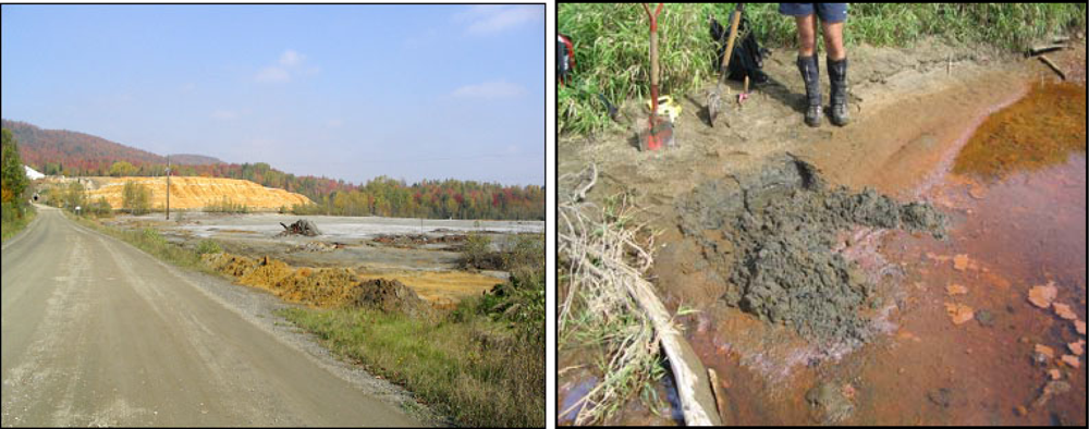
2. Industrial and Mining Heritage
3. Experimental
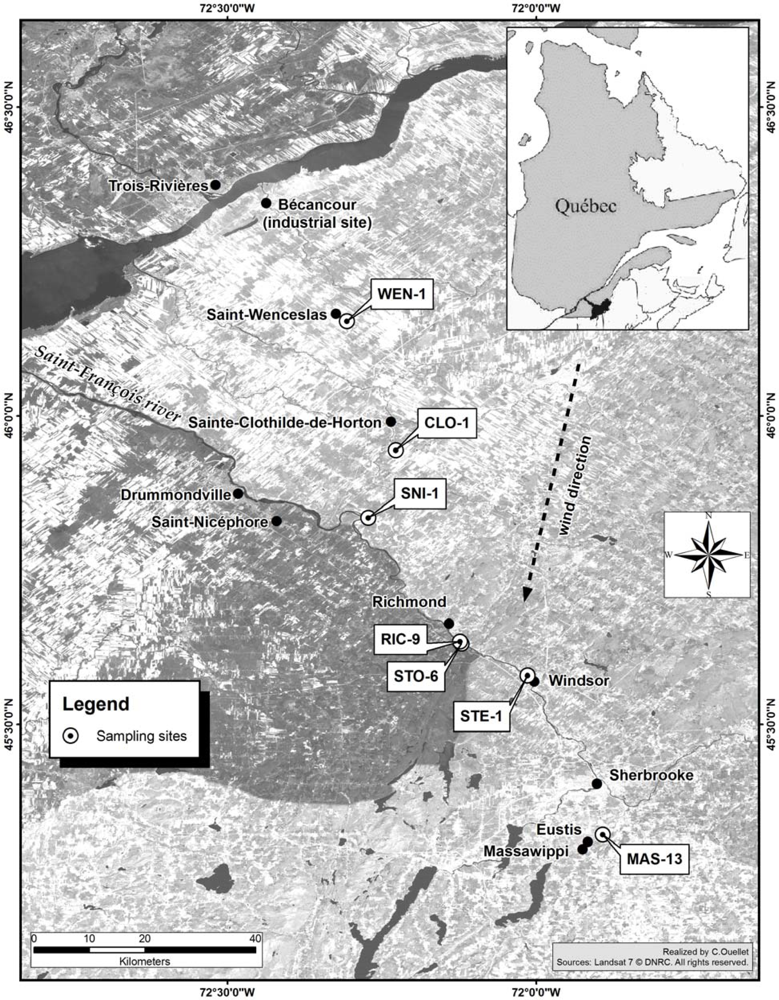
3.1. Site Description
3.2. Field Sampling
3.3. Physical and Chemical Analysis
4. Results and Discussion
4.1. Soil Sample Properties and Geochemical Characteristics
4.2. Contamination of Alluvial Soils (Riparian Zone)
4.3. Level of Contamination of Agricultural Area Soils
4. Conclusions
Acknowledgments
References
- Deniseger, J; Kwong, YTJ. Risk assessment of Copper-Contaminated sediments in the Tsolum River near Courtenay, British Columbia. Water Qual. Res. J. Canada 1996, 31, 725–740. [Google Scholar]
- Martin, CW. Heavy metal storage in near channel sediments of the Lahn River, Germany. Geomorphology 2004, 61, 275–285. [Google Scholar]
- Lim, M; Han, GC; Ahn, JW; You, KS; Kim, HS. Leachability of Arsenic and Heavy Metals from Mine Tailings of Abandoned Metal Mines. Int. J. Environ. Res. Public Health 2009, 6, 2865–2879. [Google Scholar]
- Bruyère, S; Dassargues, A; Hallet, V. Migration of contaminants through the unsaturated zone overlying the Hesbaye chalky aquifer in Belgium: A field investigation. J. Contam. Hydrol 2004, 72, 135–164. [Google Scholar]
- Mielke, HW; Gonzales, C; Powell, E; Mielke, PW. Changes of multiple metal accumulation (MMA) in New Orleans soil: Preliminary evaluation of differences between survey I (1992) and survey II (2000). Int. J. Environ. Res. Public Health 2005, 2, 308–313. [Google Scholar]
- Maldonado, VM; Rubio Aria, HO; Quintana, R; Saucedo, RA; Gutierrez, M; Ortega, JA; Nevarez, GV. Heavy metal content in soils under different wastewater irrigation patterns in Chihuahua, Mexico. Int. J. Environ. Res. Public Health 2008, 5, 441–449. [Google Scholar]
- MDDEP (Ministère du Développement Durable, de l’Environnement et des Parcs). Anomalies des Populations de Poissons. Rivière Saint-François; Gouvernement du Québec, 2006d;. MDDEP: Québec, Canada, 2002. Available online: http://www.mddep.gouv.qc.ca/poissons/st-francois/anomalie.htm (accessed on 2 August 2010).
- CCME (Canadian Council of Ministers of the Environment). Subsurface Assessment Handbook for Contaminated Sites; Report No. CCME-EPC-NCSRP-48E; CCME: Winnipeg, Manitoba, Canada, 1994. [Google Scholar]
- Kumar, A; Dey, PK; Singla, PN; Ambasht, RS; Upadhyay, SK. Blood lead levels in children with neurological disorders. J. Tropic. Pediatr 1998, 44, 320–322. [Google Scholar]
- Tripathi, RM; Raghunath, R; Mahapatra, S; Sadasivan, S. Blood lead and its effect on Cd, Cu, Zn, Fe and hemoglobin levels of children. Sci. Total Environ 2001, 277, 161–168. [Google Scholar]
- Gasana, J; Hlaing, WM; Siegel, KA; Chamorro, A; Niyonsenga, T. Blood lead levels in children and environmental lead contamination in Miami Inner City, Florida. Int. J. Environ. Res. Public Health 2006, 3, 228–234. [Google Scholar]
- Saint-Laurent, D; Hähni, M; St-Laurent, J. Spatial distribution and characterization of contaminated soils in riverbanks of Saint-François and Massawippi Rivers (Southern Québec, Canada). Water Qual. Res. J. Canada 2008, 43, 99–109. [Google Scholar]
- Ross, WG. Three Eastern Townships Mining Villages since 1863: Albert Mines, Capelton, Eustis; Department of Geography, Bishop’s University: Lennoxville, QC, Canada, 1975. [Google Scholar]
- MRNF (Ministère des Ressources Naturelles, Faune et Parcs). Restauration du site n 1 du complexe minier Eustis (Municipalité du canton de Hatley), Bulletin d’information minière, Mines Québec, Gouvernement du Québec, 2009. Available online: http://www.mrnfp.gouv.qc.ca/mines/quebec-mines/2009-06/restauration.asp (accessed on 2 August 2010).
- St-Laurent, J; Saint-Laurent, D; Duplessis, P; Begin, C. Use dendrochronological and dendrochemical methods for the datation of contamination events of the Saint-François and Massawippi riverbanks by hydrocarbons (Québec, Canada). Soil Sediment Contam 2009, 18, 1–24. [Google Scholar]
- Saint-Laurent, D; St-Laurent, J; Duplessis, P; Lavoie, L. Isotopic record of lead contamination in alluvial soils and tree rings on recent floodplains (Southern Québec, Canada). Water Air Soil Pollut 2010, 209, 451–466. [Google Scholar]
- Saint-Laurent, D; Duplessis, P; St-Laurent, J; Lavoie, L. Reconstructing contamination events on the riverbanks in southern Québec using dendrochronology and dendrochemical methods. Dendrochronologia 2010, 29. in press. [Google Scholar]
- MDDEP (Ministère du Développement Durable, de l’Environnement et des Parcs). Politique de Protection des Sols et de Réhabilitation des Terrains Contaminés; Gouvernement du Québec;. MMDEP: Québec, Canada, 2002. Available online: http://www.mddep.gouv.qc.ca/sol/terrains/politique/resume.htm#moyens (accessed on 2 August 2010).
- CEAEQ (Centre d’expertise en analyse environnementale du Québec). Détermination des Métaux Assimilables: Méthode par Spectrométrie de Masse à Source Ionisante au Plasma d’Argon, MA. 200; Ministère de l’Environnement du Québec: Quebec, Canada, 2005. [Google Scholar]
- SCWG (Soil Classification Working Group). The Canadian System of Soil Classification, 3rd ed; Agriculture and Agri-Food Canada Publication 1646; NRC Research Press: Ottawa, Canada, 1998. [Google Scholar]
- MEQ (Ministère de l’Environnement du Québec). 25 Ans d’Assainissement des Eaux Usées Industrielles au Québec: un Bilan; Ministère de l’Environnement, Gouvernement du Québec: Quebec, Canada, 1999. [Google Scholar]
- Berryman, D; Pelletier, L. Amélioration de l’état de la rivière Saint-François suite aux mesures d’assainissement dans le secteur municipal et l’industrie des pâtes et papiers. Vecteur Environnement 2001, 34, 76–80. [Google Scholar]
- MDDEP (Ministère du Développement Durable, de l’Environnement et des Parcs). Portrait Global de la Qualité de l’Eau des Principales Rivières du Québec; MMDEP: Québec, Canada, 2004. Available online: http://www.mddep.gouv.qc.ca/eau/bassinversant/global-2004/ (accessed on 2 August 2010).
- Berryman, D; St-Onge, J; Gendron, A; Brochu, C. L’Impact d’Anciens parcs à Résidus Miniers sur la Qualité de l’Eau et les Communautés Benthiques de la Rivière Massawippi et des Ruisseaux Eustis et Capel; Ministère de l’Environnement, Gouvernement du Québec: Quebec, Canada, 2003. [Google Scholar]
- Melanson, M. Analyse d’un Système de Traitement Passif pour le Site de la Mine Eustis; (Essai pour l’obtention du grade de maîtrise en Environnement); CUFE, Université de Sherbrooke: Québec, Canada, 2006. [Google Scholar]
- MDDEP (Ministère du Développement Durable, de l’Environnement et des Parcs). Critères de qualité pour la protection de la vie aquatique. Critères de Qualité de l’Eau de Surface au Québec; Gouvernement du Québec: Quebec, Canada, 2002. Available online: http://www.mddep.gouv.qc.ca/eau/criteres_eau/fondements.htm#vie-aqua (accessed on 2 August 2010).
- MDDEP (Ministère du Développement Durable, de l’Environnement et des Parcs). État de santé de la communauté piscicole de la rivière Saint-François, en 1991. Direction du suivi de l’état de l’environnement;. Gouvernement du Québec: Quebec, Canada, 2006. Available online: http://www.mddep.gouv.qc.ca/poissons/st-francois/st-francois.htm (accessed on 2 August 2010).
- Environment Canada. National Climate Data and Information Archive. Climate Data on line; Environment Canada National Inquiry Response Team: New Brunswick, Canada, 2009; Available online: http://www.climate.weatheroffice.gc.ca/climateData/canada_e.html (accessed on 2 August 2010).
- CanSIS (Canada Soil Information System). Manual for describing soil in the field. Expert Committee on Soil Survey, Research Branch, Agriculture Canada: Ottawa, Canada, 1982. [Google Scholar]
- Carter, MR. Soil Sampling and Methods of Analysis; Canadian Society of Soil Science; Lewis Publishers: Boca Raton, FL, USA, 1993. [Google Scholar]
- Yeomans, JC; Bremner, JM. A rapid and precise method for routine determination of organic carbon in soil. Commun. Soil Sci. Plant Anal 1998, 19, 1467–1476. [Google Scholar]
- Lavoie, L; Saint-Laurent, D. Pedological and sedimentological analyses of alluvial soils and paleosols on floodplain terraces. Can. J. Soil Sci 2006, 86, 1212–1233. [Google Scholar]
- Saint-Laurent, D; St-Laurent, J; Lavoie, L; Ghaleb, B. Use geopedological methods for the evaluation of sedimentation rates on river floodplains. CATENA 2008, 73, 321–337. [Google Scholar]
- McDonald, BC. Surficial Geology, Richmond-Dudswell, Quebec; Geological Survey of Canada: Ottawa, Canada, 1966. [Google Scholar]
- Choinière, J; Beaumier, M. Bruits de Fond Géochimiques pour Différents Environnements Géologiques au Québec; Ministère des Ressources Naturelles: Québec, Canada, 1997; p. 60. [Google Scholar]
- Giroux, M; Rompré, M; Carrier, D; Audesse, P; Lemieux, M. Caractérisation de la teneur en métaux lourds totaux et disponibles des sols du Québec; Ministère de l’Agriculture, des Pêcheries et de l’Alimentation du Québec: Quebec, Canada, 1992. [Google Scholar]
- Calvet, R. Le sol—Propriétés et Fonctions. Phénomènes Physiques et Chimiques: Applications Agronomiques et Environnementales; Édition France Agricole: Paris, France, 2003. [Google Scholar]
- MEF (Ministère de l’Environnement). Synthèse des informations environnementales disponibles en matière agricole au Québec. Direction des politiques du secteur agricole ENV/2003/0025. Ministère de l’Environnement du Québec: Québec, Canada, 2003; p. 143. [Google Scholar]
- Giroux, M; Deschênes, L; Chassé, R. Les éléments traces métalliques (ÉTM): Leur accumulation dans les sols agricoles du Québec. Conservation des ressources; (Summary Sheet);. IRDA: Quebec, Canada, 2008; p. 4. Available online: http://www.irda.qc.ca/_documents/_Results/162./pdf (accessed on 2 August 2010).
- Deschênes, L; Chassé, R; Giroux, M; Bastien, C; Jean, L; Beccart, V; Martineau, G; Côté, G. Développement d’une méthode d’évaluation de la mobilité et de la biodisponibilité des éléments traces métalliques d’un sol. Rapport d’étape 2, programme PARDE, MENV. Gouvernement du Québec: Québec, Canada, 2004; p. 141. [Google Scholar]

| Mean | Median | SD | Range | |
|---|---|---|---|---|
| (n = 74) pH CaCl2 | 5.15 | 5.31 | 0.90 | 3.45–7.09 |
| Organic C (% dry soil) | 0.67 | 0.66 | 0.37 | 0.05–1.56 |
| Texture analysis (SCWG) (n = 27) | ||||
| Diameter (mm) | ||||
| Sand (2.0–0.10) (%) | 61.8 | 63.6 | 14.1 | 35.6–94.3 |
| Silt (0.10–0.05) (%) | 28.2 | 27.2 | 12.6 | 3.3–52.1 |
| Clay (≤0.002 (%) | 10.1 | 10.3 | 11.2 | 2.4–25.1 |
| Eolian deposits (≥90% of sand) | ||||
| Unit (mg kg−1) | Max. values | Min. values | Average | Median | 25th percentile | 75th percentile |
|---|---|---|---|---|---|---|
| As | 38 | 1.1 | 10.0 | 8.59 | 6.21 | 12.32 |
| Al* | 12,000 | 3 600 | 6 640 | 6,250 | 5,300 | 7 025 |
| Cd | 5 | 0.03 | 0.66 | 0.48 | 0.33 | 0.72 |
| Cr | 37 | 12 | 22.1 | 23.0 | 18.75 | 26.0 |
| Cu | 120 | 5 | 39.9 | 31.0 | 28.0 | 43.0 |
| Ni | 44 | 26 | 31.6 | 34.5 | 29.75 | 37.5 |
| Pb | 149 | 3.2 | 48.0 | 21.9 | 16.75 | 34.46 |
| Zn | 1,500 | 10 | 146.8 | 93.0 | 65.0 | 111.0 |
| Unit (mg kg −1) Area/Site | As | Al | Cd | Cr | Cu | Ni | Pb | Zn |
|---|---|---|---|---|---|---|---|---|
| Richmond (RIC) | ||||||||
| Ulverton (ULV) | ||||||||
| STO-1-3 | 1 | 3,600 | 0.03 | 12 | 5 | 33 | 3 | 10 |
| STO-10-6 | 16 | - | 2.9 | 37 | 95 | 36 | 55 | 440 |
| RIC-2-8 | ND | 6,800 | ND | 19 | 25 | 22 | 18 | 37 |
| RIC-3-8 | ND | 5,000 | ND | 23 | 46 | 42 | 22 | 85 |
| RIC-9-8 | ND | 7,100 | ND | 27 | 47 | 39 | 22 | 95 |
| STE-8-6 | 12 | 6,200 | 1 | 30 | 43 | 37 | 22 | 130 |
| STO-13-6 | 15 | - | 0.71 | 23 | 120 | 30 | 30 | 88 |
| STO-15-6 | 19 | - | 4.9 | 30 | 130 | 44 | 65 | 1,500 |
| Windsor (WIN) | ||||||||
| WIN-2-8 | ND | 5,400 | ND | 19 | 29 | 30 | 13 | 49 |
| WIN-3-8 | ND | 7,000 | ND | 23 | 35 | 36 | 15 | 65 |
| STE-1-3 | 1.6 | 4,500 | 0.21 | 17 | 26 | 26 | 12 | 60 |
| STE-10-6 | 6.0 | - | 0.59 | 17 | 30 | 30 | 10 | 80 |
| Massawippi (MAS) | ||||||||
| MAS-13-3 | 4.5 | 6,200 | 0.19 | 20 | 63 | 31 | 16 | 93 |
| MAS-13-8 | ND | 6,300 | ND | 22 | 40 | 29 | 17 | 64 |
| A level* | 6 | - | 1.5 | 85 | 40 | 50 | 50 | 110 |
| B level | 30 | - | 5 | 100 | 100 | 100 | 500 | 500 |
| C level | 50 | - | 20 | 800 | 500 | 500 | 1,000 | 1,500 |
| Riparian zone (RIC-1, RIC-2, RIC-9,WIN-2, WIN-3, MAS-1, MAS-6) | Agricultural zone (Farm woodlots) (WEN-1, CLO-1, SNI-1) | |||||
|---|---|---|---|---|---|---|
| Mean | Max. | Min. | Mean | Max. | Min. | |
| Unit (mg kg−1) | ||||||
| As | 8.82 | 9.16 | 7.20 | ND | ND | ND |
| Al | 6,266 | 7,100 | 5,000 | 10,800 | 12,000 | 9,600 |
| Cd | 0.48 | 0.60 | 0.32 | ND | ND | ND |
| Cu | 37 | 47 | 25 | 12.5 | 18 | 7 |
| Cr | 22.2 | 27 | 19 | 6.5 | 10 | 3 |
| Ni | 32.2 | 42 | 22 | 7 | 11 | 3 |
| Pb | 19.97 | 25.25 | 13 | 17 | 22 | 12 |
| Zn | 69.8 | 95 | 24 | 19.5 | 24 | 15 |
| ND: Not Detected | ||||||
© 2010 by the authors; licensee Molecular Diversity Preservation International, Basel, Switzerland. This article is an open-access article distributed under the terms and conditions of the Creative Commons Attribution license (http://creativecommons.org/licenses/by/3.0/).
Share and Cite
Saint-Laurent, D.; Hähni, M.; St-Laurent, J.; Baril, F. Comparative Assessment of Soil Contamination by Lead and Heavy Metals in Riparian and Agricultural Areas (Southern Québec, Canada). Int. J. Environ. Res. Public Health 2010, 7, 3100-3114. https://doi.org/10.3390/ijerph7083100
Saint-Laurent D, Hähni M, St-Laurent J, Baril F. Comparative Assessment of Soil Contamination by Lead and Heavy Metals in Riparian and Agricultural Areas (Southern Québec, Canada). International Journal of Environmental Research and Public Health. 2010; 7(8):3100-3114. https://doi.org/10.3390/ijerph7083100
Chicago/Turabian StyleSaint-Laurent, Diane, Marlies Hähni, Julien St-Laurent, and Francis Baril. 2010. "Comparative Assessment of Soil Contamination by Lead and Heavy Metals in Riparian and Agricultural Areas (Southern Québec, Canada)" International Journal of Environmental Research and Public Health 7, no. 8: 3100-3114. https://doi.org/10.3390/ijerph7083100