Walkability, Overweight, and Obesity in Adults: A Systematic Review of Observational Studies

 ,
,
Abstract
:1. Introduction
2. Methods
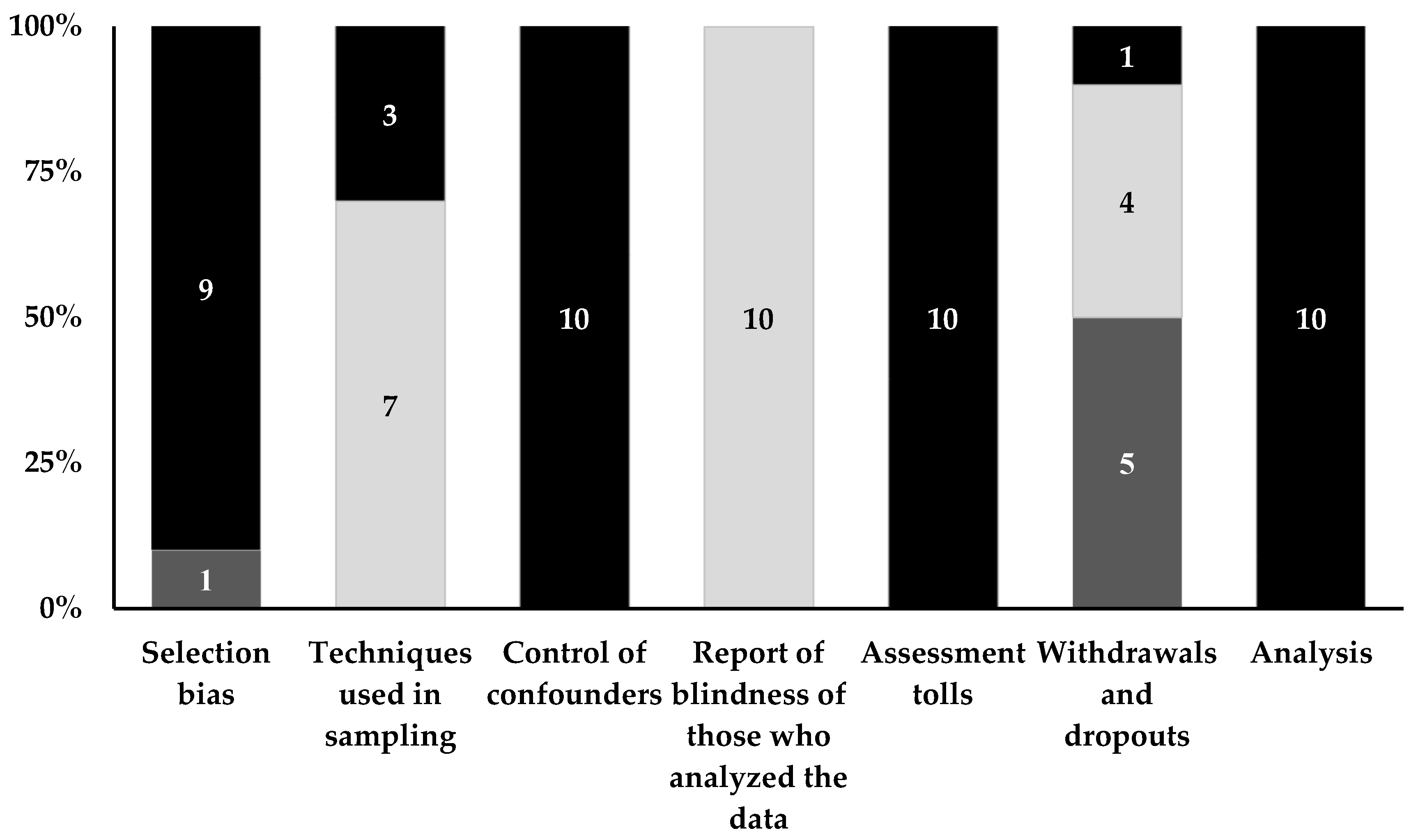
3. Results
4. Discussion
Strengths and Limitations
5. Conclusions
Supplementary Materials
Author Contributions
Funding
Acknowledgments
Conflicts of Interest
References
- ABESO. Mapa da Obesidade. Available online: http://www.abeso.org.br/atitude-saudavel/mapa-obesidade (accessed on 22 February 2018).
- Berrington de Gonzalez, A.; Hartge, P.; Cerhan, J.R.; Flint, A.J.; Hannan, L.; MacInnis, R.J.; Moore, S.C.; Tobias, G.S.; Anton-Culver, H.; Freeman, L.B.; et al. Body-Mass Index and Mortality among 1.46 Million White Adults. N. Engl. J. Med. 2010, 363, 2211–2219. [Google Scholar] [CrossRef]
- Sattar, N. Gender aspects in type 2 diabetes mellitus and cardiometabolic risk. Best Pract. Res. Clin. Endocrinol. Metab. 2013, 27, 501–507. [Google Scholar] [CrossRef] [PubMed]
- Di Angelantonio, E.; Bhupathiraju, S.N.; Wormser, D.; Gao, P.; Kaptoge, S.; de Gonzalez, A.B.; Cairns, B.J.; Huxley, R.; Jackson, C.L.; Joshy, G.; et al. Body-mass index and all-cause mortality: Individual-participant-data meta-analysis of 239 prospective studies in four continents. Lancet 2016, 388, 776–786. [Google Scholar] [CrossRef]
- NCD Risk Factor Collaboration. Trends in adult body-mass index in 200 countries from 1975 to 2014: A pooled analysis of 1698 population-based measurement studies with 19·2 million participants. Lancet 2016, 387, 1377–1396. [Google Scholar] [CrossRef]
- Bouchard, C. Physical Activity and Obesity; Manole: Barueri, Brazil, 2003. [Google Scholar]
- Sallis James, F.; Floyd Myron, F.; Rodríguez Daniel, A.; Saelens Brian, E. Role of Built Environments in Physical Activity, Obesity, and Cardiovascular Disease. Circulation 2012, 125, 729–737. [Google Scholar] [CrossRef]
- Brownson, R.C.; Hoehner, C.M.; Day, K.; Forsyth, A.; Sallis, J.F. Measuring the Built Environment for Physical Activity: State of the Science. Am. J. Prev. Med. 2009, 36, S99–S123.e12. [Google Scholar] [CrossRef] [PubMed] [Green Version]
- Swinburn, B.; Egger, G.; Raza, F. Dissecting Obesogenic Environments: The Development and Application of a Framework for Identifying and Prioritizing Environmental Interventions for Obesity. Prev. Med. 1999, 29, 563–570. [Google Scholar] [CrossRef]
- Armitage, C.J.; Conner, M. Social cognition models and health behaviour: A structured review. Psychol. Health 2000, 15, 173–189. [Google Scholar] [CrossRef] [Green Version]
- Lemmens, V.E.P.P.; Oenema, A.; Klepp, K.I.; Henriksen, H.B.; Brug, J. A systematic review of the evidence regarding efficacy of obesity prevention interventions among adults. Obes. Rev. 2008, 9, 446–455. [Google Scholar] [CrossRef]
- Shaw, K.A.; O’Rourke, P.; Del Mar, C.; Kenardy, J. Psychological interventions for overweight or obesity. Cochrane Database Syst. Rev. 2005. [Google Scholar] [CrossRef]
- Booth, K.M.; Pinkston, M.M.; Poston, W.S.C. Obesity and the Built Environment. J. Acad. Nutr. Diet. 2005, 105, 110–117. [Google Scholar] [CrossRef] [PubMed] [Green Version]
- Frank, L.D.; Schmid, T.L.; Sallis, J.F.; Chapman, J.; Saelens, B.E. Linking objectively measured physical activity with objectively measured urban form: Findings from SMARTRAQ. Am. J. Prev. Med. 2005, 28, 117–125. [Google Scholar] [CrossRef] [PubMed]
- Frank, L.D.; Saelens, B.E.; Powell, K.E.; Chapman, J.E. Stepping towards causation: Do built environments or neighborhood and travel preferences explain physical activity, driving, and obesity? Soc. Sci. Med. 2007, 65, 1898–1914. [Google Scholar] [CrossRef] [PubMed]
- Smith, K.R.; Zick, C.D.; Kowaleski-Jones, L.; Brown, B.B.; Fan, J.X.; Yamada, I. Effects of Neighborhood Walkability on Healthy Weight: Assessing Selection and Causal Influences. Soc. Sci. Res. 2011, 40, 1445–1455. [Google Scholar] [CrossRef]
- Giles-Corti, B.; Bull, F.; Knuiman, M.; McCormack, G.; Van Niel, K.; Timperio, A.; Christian, H.; Foster, S.; Divitini, M.; Middleton, N.; et al. The influence of urban design on neighbourhood walking following residential relocation: Longitudinal results from the RESIDE study. Soc. Sci. Med. 2013, 77, 20–30. [Google Scholar] [CrossRef] [PubMed] [Green Version]
- McCormack, G.R.; Shiell, A. In search of causality: A systematic review of the relationship between the built environment and physical activity among adults. Int. J. Behav. Nutr. Phys. Act. 2011, 8, 125. [Google Scholar] [CrossRef] [PubMed]
- Mendes, L.L.; Nogueira, H.; Padez, C.; Ferrao, M.; Velasquez-Melendez, G. Individual and environmental factors associated for overweight in urban population of Brazil. BMC Public Health 2013, 13, 988. [Google Scholar] [CrossRef]
- Chandrabose, M.; Rachele, J.N.; Gunn, L.; Kavanagh, A.; Owen, N.; Turrell, G.; Giles-Corti, B.; Sugiyama, T. Built environment and cardio-metabolic health: Systematic review and meta-analysis of longitudinal studies. Obes. Rev. 2019, 20, 41–54. [Google Scholar] [CrossRef]
- Mackenbach, J.D.; Rutter, H.; Compernolle, S.; Glonti, K.; Oppert, J.-M.; Charreire, H.; De Bourdeaudhuij, I.; Brug, J.; Nijpels, G.; Lakerveld, J. Obesogenic environments: A systematic review of the association between the physical environment and adult weight status, the SPOTLIGHT project. BMC Public Health 2014, 14, 233. [Google Scholar] [CrossRef]
- Grasser, G.; Van Dyck, D.; Titze, S.; Stronegger, W. Objectively measured walkability and active transport and weight-related outcomes in adults: A systematic review. Int. J. Public Health 2013, 58, 615–625. [Google Scholar] [CrossRef]
- Liberati, A.; Altman, D.G.; Tetzlaff, J.; Mulrow, C.; Gøtzsche, P.C.; Ioannidis, J.P.A.; Clarke, M.; Devereaux, P.J.; Kleijnen, J.; Moher, D. The PRISMA statement for reporting systematic reviews and meta-analyses of studies that evaluate healthcare interventions: Explanation and elaboration. BMJ 2009, 339. [Google Scholar] [CrossRef]
- Thomas, B.H.; Ciliska, D.; Dobbins, M.; Micucci, S. A Process for Systematically Reviewing the Literature: Providing the Research Evidence for Public Health Nursing Interventions. Worldviews Evid. Based Nurs. 2004, 1, 176–184. [Google Scholar] [CrossRef]
- Berry, T.R.; Spence, J.C.; Blanchard, C.; Cutumisu, N.; Edwards, J.; Nykiforuk, C. Changes in BMI over 6 years: The role of demographic and neighborhood characteristics. Int. J. Obes. (Lond.) 2010, 34, 1275–1283. [Google Scholar] [CrossRef] [PubMed]
- Berry, T.R.; Spence, J.C.; Blanchard, C.M.; Cutumisu, N.; Edwards, J.; Selfridge, G. A longitudinal and cross-sectional examination of the relationship between reasons for choosing a neighbourhood, physical activity and body mass index. Int. J. Behav. Nutr. Phys. Act. 2010, 7, 57. [Google Scholar] [CrossRef] [PubMed]
- Braun, L.M.; Rodriguez, D.A.; Song, Y.; Meyer, K.A.; Lewis, C.E.; Reis, J.P.; Gordon-Larsen, P. Changes in walking, body mass index, and cardiometabolic risk factors following residential relocation: Longitudinal results from the CARDIA study. J. Transp. Health 2016, 3, 426–439. [Google Scholar] [CrossRef] [Green Version]
- Creatore, M.I.P.; Glazier, R.H.M.D.; Moineddin, R.P.; Fazli, G.S.M.P.H.; Johns, A.M.; Gozdyra, P.M.A.; Matheson, F.I.P.; Kaufman-Shriqui, V.P.; Rosella, L.C.P.; Manuel, D.G.; et al. Association of Neighborhood Walkability With Change in Overweight, Obesity, and Diabetes. JAMA 2016, 315, 2211–2220. [Google Scholar] [CrossRef] [Green Version]
- Frank, L.D.; Sallis, J.F.; Conway, T.L.; Chapman, J.E.; Saelens, B.E.; Bachman, W. Many pathways from land use to health—Associations between neighborhood walkability and active transportation, body mass index, and air quality. J. Am. Plan. Assoc. 2006, 72, 75–87. [Google Scholar] [CrossRef]
- Lathey, V.; Guhathakurta, S.; Aggarwal, R.M. The Impact of Subregional Variations in Urban Sprawl on the Prevalence of Obesity and Related Morbidity. J. Plan. Educ. Res. 2009, 29, 127–141. [Google Scholar] [CrossRef]
- Müller-Riemenschneider, F.; Pereira, G.; Villanueva, K.; Christian, H.; Knuiman, M.; Giles-Corti, B.; Bull, F.C. Neighborhood walkability and cardiometabolic risk factors in australian adults: An observational study. BMC Public Health 2013, 13, 755. [Google Scholar] [CrossRef]
- Hoehner, C.M.; Handy, S.L.; Yan, Y.; Blair, S.N.; Berrigan, D. Association between neighborhood walkability, cardiorespiratory fitness and body-mass index. Soc. Sci. Med. 2011, 73, 1707–1716. [Google Scholar] [CrossRef] [Green Version]
- Smith, K.R.; Brown, B.B.; Yamada, I.; Kowaleski-Jones, L.; Zick, C.D.; Fan, J.X. Walkability and Body Mass Index Density, Design, and New Diversity Measures. Am. J. Prev. Med. 2008, 35, 237–244. [Google Scholar] [CrossRef]
- Thornton, L.E.; Pearce, J.R.; Kavanagh, A.M. Using Geographic Information Systems (GIS) to assess the role of the built environment in influencing obesity: A glossary. Int. J. Behav. Nutr. Phys. Act. 2011, 8, 71. [Google Scholar] [CrossRef]
- Giles-Corti, B.; Vernez-Moudon, A.; Reis, R.; Turrell, G.; Dannenberg, A.L.; Badland, H.; Foster, S.; Lowe, M.; Sallis, J.F.; Stevenson, M.; et al. City planning and population health: A global challenge. Lancet 2016, 388, 2912–2924. [Google Scholar] [CrossRef]
- Garfinkel-Castro, A.; Kim, K.; Hamidi, S.; Ewing, R. Obesity and the built environment at different urban scales: Examining the literature. Nutr. Rev. 2017, 75, 51–61. [Google Scholar] [CrossRef]
- Frank, L.D.; Sallis, J.F.; Saelens, B.E.; Leary, L.; Cain, K.; Conway, T.L.; Hess, P.M. The development of a walkability index: Application to the Neighborhood Quality of Life Study. Br. J. Sports Med. 2010, 44, 924–933. [Google Scholar] [CrossRef]
- Black, J.L.; Macinko, J. The Changing Distribution and Determinants of Obesity in the Neighborhoods of New York City, 2003–2007. Am. J. Epidemiol. 2010, 171, 765–775. [Google Scholar] [CrossRef]
- Chen, S.; Florax, R.J.G.M.; Snyder, S.; Miller, C.C. Obesity and Access to Chain Grocers. Econ. Geogr. 2010, 86, 431–452. [Google Scholar] [CrossRef]
- Drewnowski, A.; Aggarwal, A.; Hurvitz, P.M.; Monsivais, P.; Moudon, A.V. Obesity and Supermarket Access: Proximity or Price? Am. J. Public Health 2012, 102, e74–e80. [Google Scholar] [CrossRef]
- Pereira, M.A.; Kartashov, A.I.; Ebbeling, C.B.; Van Horn, L.; Slattery, M.L.; Jacobs, D.R.; Ludwig, D.S. Fast-food habits, weight gain, and insulin resistance (the CARDIA study): 15-year prospective analysis. Lancet 2005, 365, 36–42. [Google Scholar] [CrossRef]
- Frank, L.D.; Andresen, M.A.; Schmid, T.L. Obesity relationships with community design, physical activity, and time spent in cars. Am. J. Prev. Med. 2004, 27, 87–96. [Google Scholar] [CrossRef]
- McCormack, G.R.; Giles-Corti, B.; Bulsara, M. The relationship between destination proximity, destination mix and physical activity behaviors. Prev. Med. 2008, 46, 33–40. [Google Scholar] [CrossRef] [Green Version]
- Goodman, A.; Sahlqvist, S.; Ogilvie, D.; Consortium, I. New walking and cycling routes and increased physical activity: One-and 2-year findings from the UK iConnect Study. Am. J. Public Health 2014, 104, e38–e46. [Google Scholar] [CrossRef]
- Grafova, I.B.; Freedman, V.A.; Kumar, R.; Rogowski, J. Neighborhoods and Obesity in Later Life. Am. J. Public Health 2008, 98, 2065–2071. [Google Scholar] [CrossRef]
- Adlakha, D.; Hipp, J.A.; Brownson, R.C. Neighborhood-based differences in walkability, physical activity, and weight status in India. J. Transp. Health 2016, 3, 485–499. [Google Scholar] [CrossRef] [Green Version]
- Caspi, C.E.; Sorensen, G.; Subramanian, S.V.; Kawachi, I. The local food environment and diet: A systematic review. Health Place 2012, 18, 1172–1187. [Google Scholar] [CrossRef] [Green Version]
- Thornton, L.E.; Pearce, J.R.; Macdonald, L.; Lamb, K.E.; Ellaway, A. Does the choice of neighbourhood supermarket access measure influence associations with individual-level fruit and vegetable consumption? A case study from Glasgow. Int. J. Health Geogr. 2012, 11, 29. [Google Scholar] [CrossRef]
- Nogueira, R.L.; Fontanelli, D.M.; Aguiar, S.B.; Failla, A.M.; Florindo, A.A.; Barrozo, V.L.; Goldbaum, M.; Cesar, L.C.; Alves, C.M.; Fisberg, M.R. Access to Street Markets and Consumption of Fruits and Vegetables by Adolescents Living in São Paulo, Brazil. Int. J. Environ. Res. Public Health 2018, 15, 517. [Google Scholar] [CrossRef]
- Michimi, A.; Wimberly, M.C. Associations of supermarket accessibility with obesity and fruit and vegetable consumption in the conterminous United States. Int. J. Health Geogr. 2010, 9, 49. [Google Scholar] [CrossRef]
- Gorber, S.C.; Tremblay, M.; Moher, D.; Gorber, B. A comparison of direct vs. self-report measures for assessing height, weight and body mass index: A systematic review. Obes. Rev. 2007, 8, 307–326. [Google Scholar] [CrossRef]


| Reference | Country/City or Province or State (Year of Data Collection) | Sampling | Sample Size (n) | %F | Age (Mean or Range in Years) | Study Type |
|---|---|---|---|---|---|---|
| Berry et al., (2010b) [26] | Canada/Alberta (2002/2008) | nd | 1736 ** | nd | <50/≥50 | CS and L |
| Berry et al., (2010a) [25] | Canada/Alberta (2002/2008) | nd | 500 | 47.8 | 18–90 | L |
| Braun et al., (2016) [27] | USA (2000/2006) | R | 1079 | 54.8 | 44.7 | L |
| Creatore et al., (2016) [28] | Canada/Ontario (2001/2012) | nd | 5500 | 51.3 | 30–64 (1) | TS |
| Frank et al., (2006) [29] | USA/Washington (1999) | R | 75 | 44.5 | 20–65 | CS |
| Frank et al., (2007) [15] | USA/Atlanta (2001–2002) | R | 2088 | 50.6 | 40.9 | CS |
| Hoehner et al., (2011) [32] | USA/Texas (1987–2005) | nd | 16,543 | 30.3 | 18–90 (2) | CS |
| Lathey et al., (2009) [30] | USA/Arizona (2003–2005) | C | 649,513 | nd | 35.5 | CS |
| Muller-Riemenschneider et al., (2013) [31] | Australia/Perth (2003–2006) | R | 5970 | 58.0 | 25–≥65 (3) | CS |
| Smith et al., (2008) [33] | USA/Utah (2007–2008) | C | 453,927 | nd | 25–64 | CS |
| Reference | Assessment of Walkability/Study Scale/Geocoding of Facilities | Walkability Indicators Evaluated | Walkability Index Calculated | Assessment of Overweight and Obesity/Markers of Overweight and Obesity | Regression Model Used for Analyses of Associations |
|---|---|---|---|---|---|
| Berry et al., (2010b) [26] | Geocoding of neighborhoods from census data | Residential density (density of dwellings per area in residential use), land-use mix (floor areas of the following five uses: residential, retail, office, education/institutional (including religious establishments) and entertainment) and street connectivity (density of true intersections in each neighborhood) | The walkability index was calculated based on Frank et al.’s formula not including the z-score for the retail floor area, and z-scores for walkability were then classified with quantiles (five classes of equal intervals divided into very high, high, moderate, low and very low walkability neighborhood groups). | Self-reported weight and height/BMI | Linear regression/standardized and unstandardized coefficient - β |
| Berry et al., (2010a) [25] | Geocoding of neighborhoods from census data | Residential density (density of dwellings per area in residential use), land use mix (floor areas of the following five uses: residential, retail, office, education/institutional (including religious establishments) and entertainment) and street connectivity (density of true intersections in each neighborhood) | The walkability index was calculated based on Frank et al.’s formula not including the z-score for the retail floor area, and z-scores for walkability were then classified using quantiles (five classes of equal intervals divided into very high, high, moderate, low and very low walkability neighborhood groups). | Self-reported weight and height/BMI | Ordinal regression model/standardized and unstandardized coefficient - β |
| Braun et al., (2016) [27] | Geocoding from home addresses | Population density, street connectivity and food and physical activity resources within three Euclidean kilometers of each respondent’s residential location. | The walkability index was determined from measures of population density, street connectivity, and food and physical activity resources measured from participants’ pre- and post-move residential locations. | Anthropometric measurements determined from exams/BMI and WC | Fixed effect regression models (logistic and linear)/odds ratio and standardized and unstandardized coefficient - β |
| Creatore et al., (2016) [28] | Geocoding of neighborhoods from the Canadian census | Population density (number of persons per square kilometer), residential density (number of occupied residential dwellings per square kilometer), walkable destinations (number of retail stores, services [e.g., libraries, banks, community centers], and schools a ten minute walk away) and street connectivity (number of intersections with at least 3 converging roads or pathways) | Neighborhood walkability derived from a validated index with standardized scores of 0 to 100 and with higher scores denoting more walkability. Neighborhoods were ranked and classified into quintiles from lowest (quintile 1) to highest (quintile 5) walkability. | Self-reported weight and height/BMI | Poisson Regression |
| Frank et al., (2006) [29] | Geocoding, 1 km network buffer | Net residential density (residential units divided by acres in residential use), street connectivity (intersections per square kilometre), land use mix (A/ln (N)) by entropy), and the retail floor area ratio (FAR) (the retail building floor area divided by the retail land area) | Sum of z-scores of land-use mix and net residential and intersection density | Self-reported weight and height/BMI | Linear regression/standardized and unstandardized coefficient - β |
| Frank et al., (2007) [15] | Geocoding, 1 km network buffer | Net residential density (residential units divided by acres in residential use), street connectivity (intersections per square kilometer), land use mix (A/ln (N)) by entropy), the retail floor area ratio (FAR) (the retail building floor area divided by the retail land area) | Sum of z-score land-use mix, net residential density and intersection density and divided into quartiles (lowest quartile, second quartile, third quartile and highest quartile) | Self-reported weight and height/BMI | Logistic regression/odds ratio and linear regression/standardized coefficient - β |
| Hoehner et al., (2011) [32] | Geocoding of neighborhoods by home address and residential block group | Traditional core (higher values corresponding to block groups with older homes and residents with shorter commute units), high density (higher values corresponding to block groups of higher populations and housing unit densities) and non-auto commuting (higher values corresponding to block-groups with a higher proportion of commute trips made by walking, bicycling, or public transport) | Block-group level measures of population density, housing type, median home age, and commuting patterns representing neighborhood walkability divided into different factors such as traditional core, high density and non-auto commuting. These factors were interpreted and analyzed separately | Weight and height/BMI | Fit regression model/standardized and unstandardized coefficient (β) |
| Lathey et al., (2009) [30] | Geocoding by census block group | Population density, land use, connectivity, locations for social interaction | The walkability index was calculated and divided into three groups: low (reference), average and high prevalence. | Weight and height/BMI | Multinomial logistic regression/odds ratio |
| Muller-Riemenschneider et al., (2013) [31] | Geocoding, 800 and 1600 m network buffers | Residential density (the ratio of residential dwellings to residential area in hectares), street connectivity (the ratio of three or more intersections to area in km2), land use mix (calculated with an entropy formula adapted from that developed by Frank et al. 2005 that considers the proportion of area covered by each land use type from the summed area for all land use types of interest divided by the number of land use classes) | The walkability index was calculated by summing the z-scores of each component | Self-reported weight and height/BMI | Logistic regression/odds ratio |
| Smith et al., (2008) [33] | Geocoding of neighborhoods by census block group - 2000 census for Salt Lake County, Utah | Population density, street connectivity, proportion of residents walking to work, the age of housing | Four D (density: population per square mile, design: intersections over 0.25 miles, diversity: proportion walking to work, and diversity: housing age) representing neighborhood walkability. These factors were interpreted and analyzed separately | Self-reported weight and height/BMI | Logistic regression/odds ratio and Linear regression/standardized coefficient - β |
| Reference | Walkability Variables | Variable of Walkability (Score or Categorical) | Overweight and/or obese | Variable for Overweight and Obesity (Continuous/Categorical) | β-Values | Other-Values | OR-Values | 95% CI | p-Value | Variables Adjusted | An Association (+) or No Association (ns) Found | |||
|---|---|---|---|---|---|---|---|---|---|---|---|---|---|---|
| Walkability-Index | ||||||||||||||
| Berry et al., (2010a) [25] | Lowest Walkability index | Categorical | BMI | Continuous | 0.479 | 0.096 | Age, sex, marital status, education, physical activity, fruit and vegetable consumption, neighborhood socioeconomic status | ns | ||||||
| Low Walkability index | 0.251 | 0.339 | ||||||||||||
| Moderate Walkability index | 0.149 | 0.562 | ||||||||||||
| High Walkability index | 0.3 | 0.232 | ||||||||||||
| Highest Walkability index (Reference) | - | - | ||||||||||||
| Creatore et al., (2016) [28] | Walkability index (Population density, residential density, walkable destinations (land use) and street connectivity) in quintiles absolute change adjusted values (prevalence) | Categorical | BMI | Categorical | Less walkable neighborhood (quintile 1) vs. most walkable neighborhood (quintile 5) = 43.3% vs. 53.5% | Adjusted prevalence | Age, sex, income and ethnicity | |||||||
| Quintile 1 (%) = 5.4 | 2.1%–8.8% | 0.002 | + | |||||||||||
| Absolute difference = 10.2% (95% CI, 13.5% to 6.8%; p < 0.001 | Quintile 2 (%) = 6.7 | 2.3%–11.1% | 0.003 | |||||||||||
| Quintile 3 (%) = 9.2 | 6.2%–12.1% | <0.001 | ||||||||||||
| Quintile 4 (%) = 2.8 | −1.4%–7.0% | 0.20 | ||||||||||||
| Quintile 5 (%) = 2.1 | −1.4%–5.5% | 0.20 | ||||||||||||
| Lathey et al., (2009) [30] | Walkability index (population density, land use, connectivity, locations for social activity) low (reference), medium and high | Categorical | BMI | Categorical | Low (reference) | Demographic and socioeconomic characteristics of a neighborhood | + | |||||||
| Average = 0.62 | <0.05 | |||||||||||||
| High = 0.50 | <0.001 | |||||||||||||
| Muller Riemenschneider et al., (2013) [31] | Less walkable vs. highly walkable neighborhoods (1600 m buffers) | Categorical | BMI (≥30 Kg/m2) | Categorical | Overall = 0.86 | 0.70–1.05 | 0.139 | Age, sex, education level, household income, marital status, physical activity and sedentary behaviour | + | |||||
| Male = 0.82 | 0.59–1.14 | 0.229 | ||||||||||||
| Female = 0.88 | 068–1.14 | 0.336 | ||||||||||||
| Less walkable vs. highly walkable neighborhoods (800 m buffers) | Overall = 0.78 | 0.64–0.96 | 0.018 | |||||||||||
| Male = 0.76 | 0.55–1.04 | 0.089 | ||||||||||||
| Female = 0.80 | 0.61–1.04 | 0.093 | ||||||||||||
| Braun et al., (2016) [27] | Walkability index (population density, street connectivity, variables related to food and physical activity) | Score | BMI | Continuous | Fixed effects | Random–effects | Fixed effects | Random effects | Fixed effects adjusted for time (days between exams) and time-varying sociodemographic and health covariates (income, household size, marital status, employment status, smoking status, and health problems that interfere with physical activity) Random effects adjusted for time (days between exams), sociodemographic and health covariates (baseline age, sex, race/ethnicity, educational attainment, income, household size, marital status, employment status, smoking status, and health problems that interfere with physical activity), and reasons for moving to the current neighborhood (moved due to the built environment) | ns | ||||
| −0.022 | −0.018 | 0.778 | 0.793 | |||||||||||
| WC | −0.232 | −0.26 | 0.391 | 0.283 | ||||||||||
| Hoehner et al., (2011) [32] | Walkability factors (traditional core, high density and non-auto commuting) | Score | BMI (women) | Continuous | Traditional core = −0.194 | <0.01 | Age and examination year and block group level percentage of non-Hispanic Blacks and Hispanics, percentage falling below the 200% poverty level, participation in outdoor physical activities (walking, jogging, or bicycling) and cardiorespiratory fitness | + | ||||||
| High–density = −0.171 | NS | |||||||||||||
| Non-auto commuting = −0.028 | NS | |||||||||||||
| BMI (men) | Traditional–core = −0.210 | <0.05 | ||||||||||||
| High–density = −0.158 | <0.001 | |||||||||||||
| Non-auto commuting = −0.100 | <0.05 | |||||||||||||
| Berry et al., (2010b) [26] | Residential density, land use mix and connectivity | Score and categorical | BMI-(longitudinal) | Continuous | −0.068 | 0.116 | Age, sex, marital status, education, physical activity, fruit and vegetable consumption, proximity to workplace, proximity to outdoor recreation amenities, quality of schools, quality of walking infrastructure, neighborhood socioeconomic status | ns | ||||||
| BMI (cross- sectional) | −0.051 | 0.091 | ||||||||||||
| Frank et al., (2006) [29] | Walkability index (residential density, street connectivity/land use, proportion of built area) | Score and categorical | BMI | Continuous | Unstandardized–coefficient | Standardized–coefficient | Sex, age, education, ethnicity, children under the age of 18 and household income | + | ||||||
| −0.149 | −0.113 | <0.001 | ||||||||||||
| Frank et al., (2007) [15] | Walkability index (residential density, street connectivity/land use, proportion of built area) in quartiles | Score and categorical | BMI | Categorical | –- | Lowest quartile (reference) | - | - | No variables adjusted | + | ||||
| Second quartile = 0.98 | 0.70–1.38 | NS | ||||||||||||
| Third quartile = 0.83 | 0.59–1.16 | NS | ||||||||||||
| Highest quartile = 0.67 | 0.49–0.89 | <0.05 | ||||||||||||
| Other variables | ||||||||||||||
| Smith et al., (2008) [33] | Density: population density | Score and categorical | BMI (women) | Categorical–and–continuous | 0.000 | 0.663 | No variables adjusted | + | ||||||
| Design: street connectivity | 0.000 | 0.981 | ||||||||||||
| Diversity: proportion of residents walking to work | −6.829 | <0.001 | ||||||||||||
| Diversity: age of housing | −0.015 | <0.001 | ||||||||||||
| Density: population density | BMI (men) | −0.001 | 0.336 | |||||||||||
| Design: street connectivity | −0.002 | 0.092 | ||||||||||||
| Diversity: proportion of residents walking to work | −5.376 | <0.001 | ||||||||||||
| Diversity: age of housing | −0.019 | <0.001 | ||||||||||||
© 2019 by the authors. Licensee MDPI, Basel, Switzerland. This article is an open access article distributed under the terms and conditions of the Creative Commons Attribution (CC BY) license (http://creativecommons.org/licenses/by/4.0/).
Share and Cite
Paulo dos Anjos Souza Barbosa, J.; Henrique Guerra, P.; de Oliveira Santos, C.; de Oliveira Barbosa Nunes, A.P.; Turrell, G.; Antonio Florindo, A. Walkability, Overweight, and Obesity in Adults: A Systematic Review of Observational Studies. Int. J. Environ. Res. Public Health 2019, 16, 3135. https://doi.org/10.3390/ijerph16173135
Paulo dos Anjos Souza Barbosa J, Henrique Guerra P, de Oliveira Santos C, de Oliveira Barbosa Nunes AP, Turrell G, Antonio Florindo A. Walkability, Overweight, and Obesity in Adults: A Systematic Review of Observational Studies. International Journal of Environmental Research and Public Health. 2019; 16(17):3135. https://doi.org/10.3390/ijerph16173135
Chicago/Turabian StylePaulo dos Anjos Souza Barbosa, João, Paulo Henrique Guerra, Crislaine de Oliveira Santos, Ana Paula de Oliveira Barbosa Nunes, Gavin Turrell, and Alex Antonio Florindo. 2019. "Walkability, Overweight, and Obesity in Adults: A Systematic Review of Observational Studies" International Journal of Environmental Research and Public Health 16, no. 17: 3135. https://doi.org/10.3390/ijerph16173135